
Abstract
This paper explores the realities of voyaging as understood by early Polynesian navigators. The voyaging world of Kaveia, a contemporary navigator from Outlier Polynesia, as recorded by the anthropologist sailor Mimi George, is juxtaposed with those of Tupaia and Puhoro, eighteenth century navigators from the Society Islands, to examine Polynesian understandings of the sea, canoes and islands, and how long-distance voyaging was accomplished in ancestral times. The renaissance in Polynesian voyaging is also examined, in the context of human harm to the oceanic realm, and modernist understandings of relations between people and the sea are interrogated.
At Borabora in 1818, a half-blind old woman named Ruanui sat with the missionary John Orsmond and chanted the Tahitian creation story. In the beginning, she said, everything emerged from Rua-tupua-nui, the source of growth. When Rua-tupua-nui slept with Atea-ta'o-nui (great expanse), the shooting stars were born, and then the moon, the sun and comets, constellations and the planets.
After the planet Ta'urua (Venus) emerged, he prepared his canoe and sailed west across the sky where he met his wife Rua-o-mere (Capricornus), and they had Maunu'ura (Mars). Maunu'ura sailed south in his canoe and met his wife Apu-o-te-ra'i (vault of the sky), and they had Ta'urua (Formalhault), the steersman of Atutahi's canoe (Atutahi / Pisces Australis). When Atutahi sailed to the West, he came together with Tu-i-te-moana-‘urifa (Hydra), and other stars were born.
As each star emerged, they sailed across the skies on their canoes, and other stars were created. The curved arcs of the layered skies were raised up on pou, or star pillars,
1
and when the kings of the chiefs of the earth and the kings of the skies were born, they each had their own star whose names were given to their marae, or ceremonial centres. At this time,
there was prayer in the moving, rolling ocean, the sea was the great marae of the world … . Tumu (the rock of foundation) was the husband, Papa (the earth) was the wife, and Oro-pa'a was born to them who still lives in the ocean. He lies with his head upwards, the white foaming breakers are his jaws, he swallows whole fleets of people, he does not spare princes. (Henry 1928, 355)
In this vast oceanic realm, islands were fish, hauled up out of the ocean by the first voyaging ancestors, including Maui, Hiro and Rata. The first dorsal fin of the fish known as Tahiti was its highest mountain, while its second fin was the peninsula Tahiti-iti (Henry 1928, 437–443). Each district had its own mountain, cape and marae, with a star (‘avei'a) standing above it. When the creator ancestor Ta'aroa turned himself into the first canoe, his daughters hauled it to the marae, where it became the first fare atua (god house): ‘The backbone was the ridgepole, the ribs the supporters of the god's house, the breast-bone the capping of the roof, the thigh bones the carved ornaments around the god's house’ (Henry 1928, 426).
According to these accounts, land and sea, plants and animals, stars and winds, canoes, god's houses and people were all linked together in one vast kin network. Particular beings could appear in the everyday world in different guises – Ta'aroa as an ancestor, a canoe or a god house; islands as fish; stars as ancestors, pillars or canoes sailing through the sky; whales and sharks as manifestations of ancestors.
Two hundred years later, it is difficult to grasp the kind of reality that underpins these accounts. In outlier Polynesia, 2 however, where ancestral voyaging traditions have survived into contemporary times, they have been passed on to a new generation of navigators. On Taumako, for instance, one of the Duff Islands in far western Polynesia, the aliki (high chief) Kaveia began to train a younger generation, including an anthropologist named Mimi George who learned from him over 16 years, sailing with him or directed by him on 25 voyages (George 2012, 140).
In the process, George learned a good deal about sailing with mana (ancestral power) on an ocean where the winds, stars, the sea itself, the navigators and their canoes are all ancestors. More recently, she has begun to record these experiences. In Taumako, according to Kaveia, the founding ancestor, Lata (Rata in Tahiti and Aotearoa New Zealand 3 ), built the first voyaging canoe. His powers are used by Taumako navigators to predict and influence the weather, shift winds and waves, and ensure a safe passage between the islands (an ancestral sailing system known as Te Nohoanga te Matangi). 4 The hull of their outrigger canoes (‘Te Vaka o Lata’) is exceptionally efficient, stabilising the craft. The wings of their crescent-shaped sails (‘Te Laa o Lata’) are Lata's arms, reaching up to grasp the wind. The belly of the sail is Lata's belly and his mana powers the vessel, while the navigator becomes a living Lata during the voyage. The end of the yard is stepped into a divot carved into the image of a bird lashed to the top of each bow, and ‘Lata's teeth’ bite into the base of this image from the hull. This type of sail is very powerful, especially with a side or following wind. Under sail, and properly trimmed, the main hull is submerged, except for the carved bird that helped Lata to build the craft, although the prow may plow into the water in steep swells. Lata is at once an ancestor, a navigator, a canoe and a sail, each powered by ancestral mana (George 2018).
As an anthropologist and experienced sailor, George had to unmoor some of her own ontological assumptions to grasp the ‘fail-safe’ systems used by Taumako navigators, including calling upon Lata in times of danger (George 2012, 147–151). The Taumako wind compass is centred on Lata and animated by his mana, shaping the world. 5 Lata ‘dances’ with the wind, shifting particular winds around the horizon in their seasonal cycle, and if need be, modifying their position to ensure a safe path between islands, pushing the winds with ancestral power. During a voyage, when Kaveia became Lata, he would sit calmly at the entryway to the cabin on his canoe, working with winds, currents and the stars as the destination island floated towards them. After his death, he appeared on board his canoe to guide those whom he had trained on their voyages, as George vividly describes (2018, 401–404).
According to George, during their voyages together, Kaveia's meteorological forecasts were invariably accurate (2018, 404). She recounts the efficacy of his use of lime-tipped ‘weather sticks’ to shift particular winds (within their seasonal range) and control waves and rain (2018, 397, 401). Taumako navigators know how to read intricate swell patterns in the ocean (George 2012, 159–165), bouncing off particular islands, the sequences (or ‘avei'a) of rising and setting stars, the rising and setting of the sun, the reflection of islands and lagoons on clouds, and migrating and homing birds to find a destination island. George also gives a rich account of lapa, flashes like lightening that streak across the ocean from particular islands, each with their own signature; sea paths made visible by Lata's presence that also indicate particular kinds of weather (2012, 150–159). All of these devices Kaveia used to meet ‘the stern test of landfall’ (Lewis 1972, 43), the empirical proof of navigational skill – finding a destination island rather than perishing in the ocean.
Although George was taught by Kaveia because he wanted the Taumako voyaging tradition recorded for future generations, she found it very difficult to write about those aspects of his navigational practice that exceed the limits of Western rationality. If described in a matter of fact way, these observations invite disbelief, and even ridicule. 6 Indeed, most Western accounts of Polynesian navigation are constrained by assumptions that exclude the reality of ancestral presence and power, and the ability of beings from the ancestral realm to adopt different forms in the realm of everyday world. Arguably, these ontological refusals fundamentally distort our understandings of how the ancestors of Polynesian people were able to explore and settle the Pacific Ocean, given that ancestral beings including the winds, the stars, sea, birds, fish, the navigator him or herself and their canoes, were at the heart of their voyaging system.
Indeed, from the time that the first European ships arrived in Tahiti, one of the islands in the Society Island archipelago, it was clear that Tahitian voyaging was both inspired and driven by ancestral power. At that time Taputapuatea in Ra'iaea, the main marae (ceremonial centre) of ‘Oro, the god of fertility and war, was the hub of an extensive voyaging network. Every year, ‘Oro's followers, the ‘arioi, a society of artists, dancers, musicians, warriors, priests and navigators, carried the gods from island to island, activating the seasonal ritual cycle.
The highest grade of ‘arioi, the ‘black legs,’ men and women distinguished by their red bark-cloth garments and black tattooed legs, enjoyed a privileged lifestyle. Large houses were built to shelter them on their travels, and feasts were staged for their entertainment. They were lavished with gifts, presented with sexual partners and took what they wanted. On their expeditions, fleets of canoes assembled, and travelled under ‘Oro's protection to other islands.
7
The missionary William Ellis, who lived in the archipelago during the early nineteenth century, gave a vivid description of the arrival of an ‘arioi flotilla:
[The canoes] advanced towards the land, with their streamers floating in the wind, their drums and flutes sounding, and the Areois, attended by their chief, who acted as their prompter, appeared on a stage erected for the purpose, with their wild distortions of person, antic gestures, painted bodies, and vociferated songs, mingling with the sound of the drum and the flute, the dashing of the sea, and the rolling and breaking of the surf … the whole … presented a ludicrous imposing spectacle.
8
In 1769, when James Cook's Endeavour arrived in Tahiti to observe the Transit of Venus with his Royal Society party of artists and scientists, they soon met Tupaia, a ‘black leg’ ‘arioi, tahu'a (high priest) of the Papara district, and a skilled fa'atere (navigator). Tupaia had trained at Taputapuatea, and in about 1760 when Ra'iatea was invaded by warriors from Borabora, a neighbouring island, he fought against them. After the high chief of the island was killed, Tupaia took the high chief's son, a red feather girdle and an image of ‘Oro on board ‘Oro's sacred canoe and carried them to safety in Papara in Tahiti. There he became the lover of Purea, the female ari'i (high chief) of the district, and tried to help her to install her son as the paramount chief of the island. The other ari'i joined forces against them, however, and not long before the Endeavour arrived at the island, their warriors were defeated in a series of battles (Figure 1).
‘Arioi war canoes. ‘War Boats of Otaheite,’ by William Hodges. National Maritime Museum, London.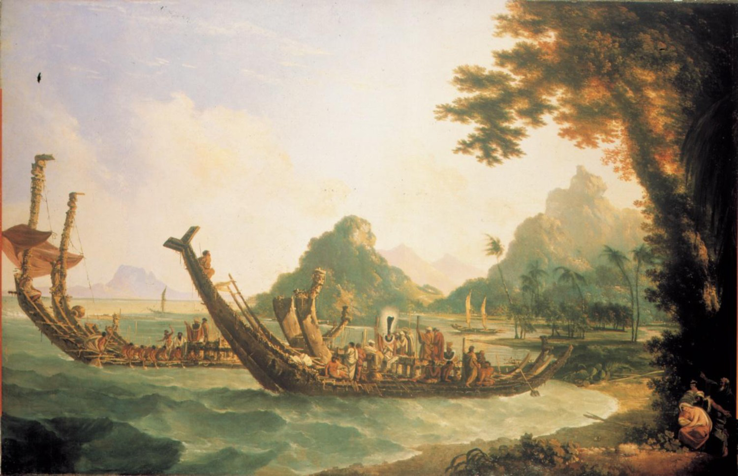
Although Tupaia had not been exiled, he was now in a marginal position. As an artist and navigator, he was fascinated by the Royal Society party with their watercolours, observatory and astronomical instruments. When Joseph Banks, the wealthy young leader of the Royal Society party, travelled to Mo'orea to observe the Transit of Venus, Tupaia went with him; and on Tahiti, he worked closely with Sydney Parkinson, the ship's artist, sketching marae, ‘arioi long-houses, canoes, dancers and musicians, and the chief mourner at a death ritual. 10
Tupaia also worked with James Cook and Robert Molyneux, the ship's master, sharing some of his knowledge about voyaging and navigation, eventually giving them the names of about 130 islands (Salmond 2005, 2008). In Polynesia, where voyaging itineraries were commonly recited as island lists, these itineraries typically included the bearing of the destination island from a particular point on the home island; the succession of stars rising on that bearing throughout the journey (the rua or star path); the duration of the journey in po or nights; the zenith star (‘avei'a) that marked the position of the destination island; and information about each island, including its name; size; whether it was low or high; whether or not it had a reef; the location of good harbours; the main foodstuffs produced there; whether or not it was inhabited; whether or not the people were friendly; and the name of its ari'i or high chief (Figure 2).
11
Tupaia's sketch of an ‘arioi long house and canoes. ‘A Scene in Tahiti,’ by Tupaia, British Library, Add MS 15508, f. 14.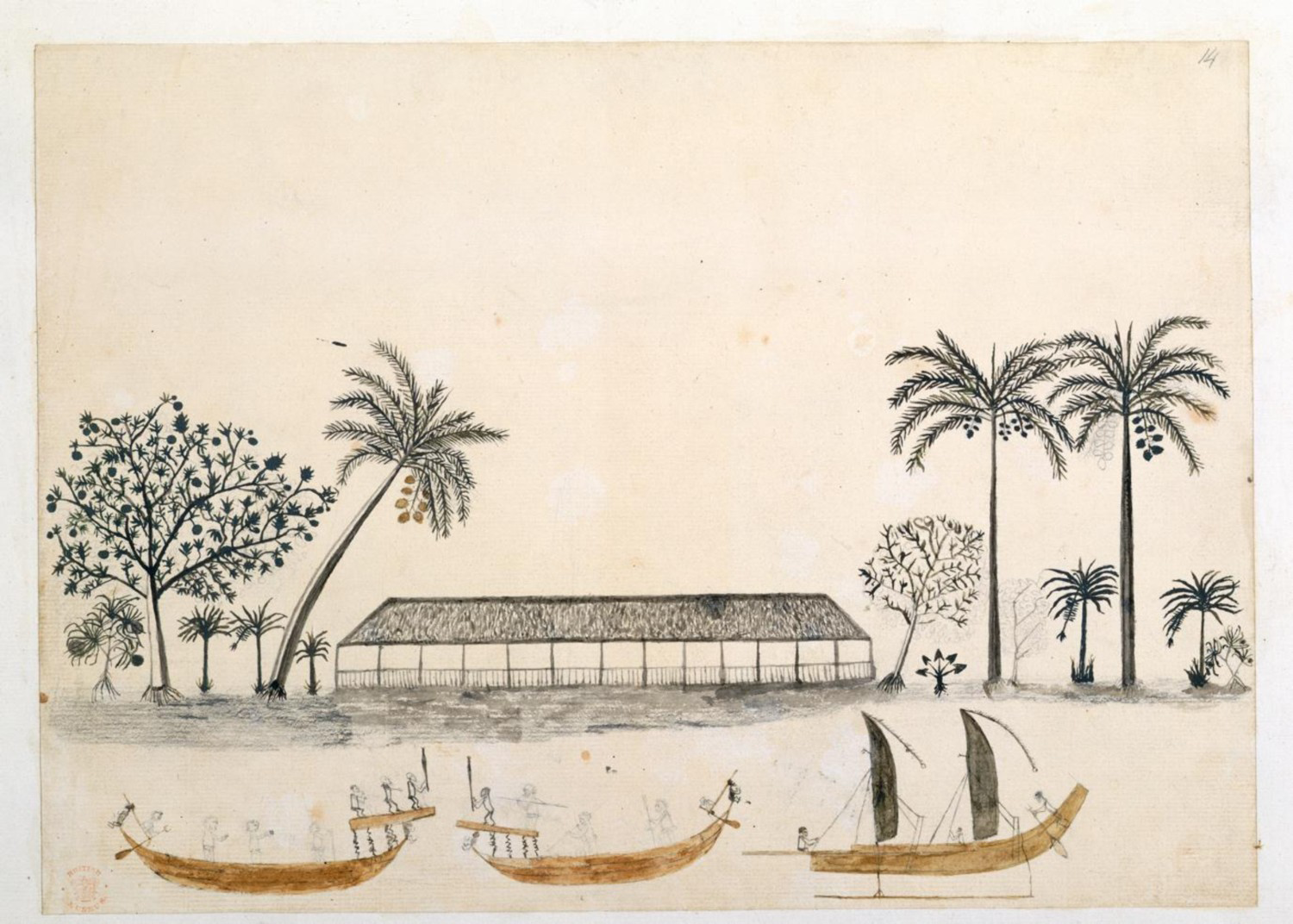
Much of this information (the star paths, for instance) would have been too difficult to share with Cook and Molyneux, or too detailed; and their transcriptions of his lists include only the island names and their bearings from Tahiti. 12 According to Johann Forster's later account, Tupaia ‘gave directions for making one according to his account, and always pointed to that part of the heavens, where each isle was situated.’ 13 During these conversations, he also shared different aspects of his navigational knowledge, so that Cook's and Molyneux's transcriptions of his lists have only 39 islands in common. Tupaia's lists also include place names from the origin stories, for instance Tumu-papa, a name most likely referring to the creator Tumu (Ta‘aroa's phallus) and Papa, the Earth; and various names beginning with Hiti-, evidently drawn from the story of the ancestral voyager Rata (Hiti-teare, Hiti-tautaureva, Hiti-tautaumai, Hiti-poto, Hiti-te-tamaruire, etc.), cosmological features that, from a European point of view, were not real.
On the island list he recorded, James Cook marked the names of twenty islands Tupaia said he had visited, including at least ten in the Society Islands,
14
Niue, two islands in Eastern Samoa, Rurutu (Orurutu), and two in the Cook Islands.
15
This suggests that in the mid-eighteenth century, the ‘arioi were voyaging extensively east, west and south from Tahiti. As Molyneux remarked,
Tobia's Office as Priest has not hinder'd him from travelling which he is very fond of the following extract is from a list of His but sometimes he recollects many more [islands] than is here mentioned … Towbia has seen many of these Islands & has a number more on Tradition that are not here mention'd he is very steady in his account.
16
When the ship approached Huahine, Tupaia sent a local man to dive down beneath the keel to see how much water it drew, guiding the Endeavour safely through a passage through the reef into the harbour. When he escorted Cook and his party ashore, the high priest stripped to the waist, asking Dr Monkhouse (the ship's surgeon) to do the same as a sign of respect to the gods of the island. Three days later, Tupaia set the course for Ra'iatea, guiding the ship through Te Ava Moa (the sacred pass) through the reef to Taputapuatea, the heart of the ‘arioi cult and his home marae, where he failed to convince Cook to attack the Borabora invaders. Afterwards they carried on to Tahaa, Borabora and Hamanino Bay, Tupaia's birthplace on Ra'iatea, a snug cove sheltered by an offshore reef now occupied by Borabora warriors, where Cook and Banks examined numerous boathouses along the coastline, sheltering large canoes with bellied sides and high peaked sterns, which Tupaia had told them sailed on journeys that took 20 days or more (Banks in Beaglehole 1962, I: 154), but only at certain times of the year (Figure 3).
Tupaia's Chart of Leeward Society Islands, with place names written by Joseph Banks. ‘Society Islands discovered by Lieut. J. Cook,’ British Library Add MS 15508, f.16.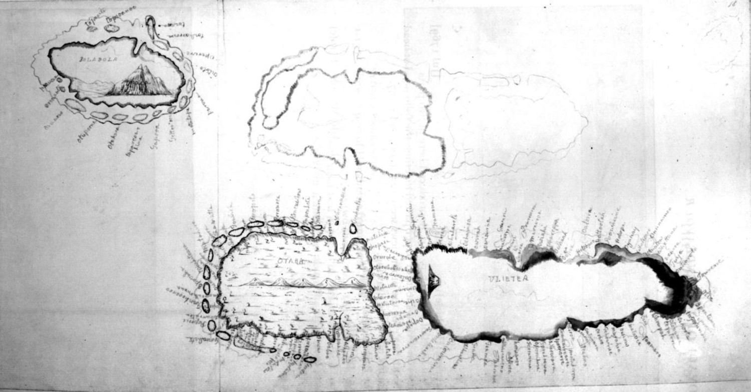
During this passage through the Society Islands, Tupaia closely worked with Joseph Banks on a chart of the Leeward group, dictating place names and district names which Banks inscribed around the coastlines of the islands.
17
As a result of these exchanges, Cook came to a conclusion about the exploration and settlement of the Pacific that anticipated contemporary scientific findings:
In these Pahee's [pahi], … these people sail in those seas from Island to Island for several hundred Leagues, the Sun serving them for a compass by day and the Moon and stars by night. When this comes to be prov'd we Shall be no longer at a loss to know how the Islands lying in those Seas came to be people'd, for if the inhabitants of Uleitea have been at Islands laying 2 or 300 Leagues to the westward of them it cannot be doubted but that the inhabitants of those western Islands may have been at others as far to westward of them and so we may trace them from Island to Island quite to the East Indias. (Cook in Beaglehole 1955, 154)
Tupaia's most remarkable contribution, however, was a chart of the islands in the seas around Tahiti, which many scholars have tried to decipher.
19
The latest example, a long, detailed article by Lars Eckstein and Anja Schwarz, is based on a meticulous analysis of three surviving copies of the chart, the surviving island lists, the Endeavour logs and journals, modern insights into Cook's cartography, and fragmentary ideas about Polynesian voyaging and navigation (Eckstein and Schwartz 2019; Salmond 2019b). The first version of this chart was drafted after the Endeavour's visit to Rurutu, when Tupaia's direct knowledge of the islands south of Tahiti had been exhausted.
20
It seems that first, Cook, Molyneux or perhaps Isaac Smith, Cook's nephew who assisted him in drafting the ship's charts, or Lieutenant Pickersgill, who completed a copy of Tupaia's chart, laid out the Society islands on the basis of their own charts (to which Tupaia had already contributed). Next, Tupaia placed and named a series of other islands on the chart in relational arrays based on voyaging itineraries that he had memorized during his training and experienced as an ‘arioi navigator (Figure 4).
Tupaia's Chart of the Pacific Ocean. Tupaia's Chart of the Pacific Ocean British Library, 21592C.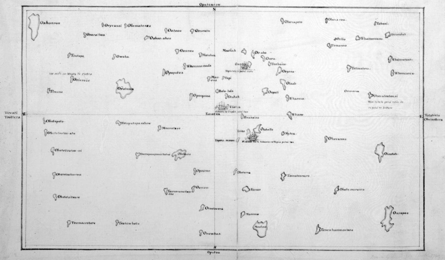
A second iteration of the chart, drafted in Queen Charlotte Sound in Aotearoa, added new information after Tupaia had talked with a local rangatira (chief) about Maori voyaging and geographical knowledge (Eckstein and Schwartz 2019, 78–79). Again, however, none of the Europeans directly involved in this process described exactly how they worked with Tupaia, so many of Eckstein and Schwartz's reconstructions remain speculative. It is clear, however, that for many Maori, at least, the Endeavour was Tupaia's ship, and that in many ways, this became an ‘arioi voyage (Salmond 2003, 188–189).
From the evidence of the chart and the island lists, it is plain that in Tupaia's time, Tahitian navigators often made long distance voyages. This led Cook and his companions to respect his navigational expertise, and as we have seen, they did not doubt that island navigators were capable of voyages of exploration, or that their ancestors had settled a vast sweep of the Pacific Ocean. They were also impressed by Tupaia's knowledge of the stars, and his ability to orient himself at sea. As Johann Reinhold Forster later wrote:
Tupaia was so well skilled in this, that wherever they came with the ship during the navigation of nearly a year, previous to the arrival of the Endeavour at Batavia, he could always point out the direction in which Taheitee was situated. (Forster 1778, 509)
During the voyage to Lima, Puhoro dictated a list of 15 islands to the east of Tahiti (including most of the NW Tuamotus) and 27 islands to the West, including many of the Society Islands, Atiu and Rarotonga in the Cook Islands, islands in the Marquesas and Fenua Teatea and Ponamu (which Tupaia had not included in his island lists, almost certainly the North and South Islands of New Zealand). As he listed each island, Puhoro made comments about its topography and reefs, its main produce, whether or not the island was inhabited, the ferocity or otherwise of its inhabitants, and how many days it took to sail there from other named islands. Again, the precise sequences of stars to be followed from one island to another were not given, however, in part because it was too difficult to calibrate Tahitian names of stars and constellations with those used by Europeans, and because Tahitian navigation used features such as dark shapes in the sky that were not as significant in European astronomy. 21
Like Tupaia, Puhoro was an excellent source of knowledge about Tahitian navigational methods, telling the Spaniards about the wind compass used by his compatriots, dictating the names of its 16 points, and explaining how they used the stars to sail to their destinations.
22
According to y Varela:
from him and others, I was able to find out the method by which they navigate on the high seas: which is the following. They have no mariner's compass, but divide the horizon into sixteen parts, taking for the cardinal points those at which the sun rises and sets […] He knows the direction in which his destination bears: he sees, also, whether he has the wind aft, or on one or other beam, or on the quarter […] When the night is a clear one, they steer by the stars; and this is the easiest navigation for them because, these being many [in number], not only do they note by them the bearing on which the several islands with which they are in touch lie, but also the harbours in them, so that, they make straight for the entrance by following the rhumb of the particular star that rises or sets over it; and they hit it off with as much precision as the most expert navigator of civilized nations could achieve. (Corney 1919, 284)
In addition, the Spaniards remarked on the uncanny accuracy with which Puhoro predicted the next day's weather each evening, ‘a foreknowledge worthy to be envied, for, in spite of all that our navigators and cosmographers have observed and written about the subject, they have not mastered this accomplishment.’ 23
Invariably, however, as with Tupaia's chart and accounts of Tahitian navigation, ontological as well as linguistic constraints limited these exchanges. A world in which ancestors rode the winds and star ancestors sailed their star canoes across the curved skies; and islands were fish, swimming or floating towards the navigator's craft, which stood still in the ocean; or where navigators became ancestors during their journeys, calling on their mana to summon the winds or calm the sea; or ancestral sharks, whales or birds acted as guardians for a voyaging party – then as now, such accounts were regarded as metaphorical, or ‘myths’ or ‘beliefs’ rather than ‘matter of fact’ accounts of relationships in an oceanic world that enabled the ancestors of Polynesians to invent blue water sailing, and explore and settle the Pacific.
As Teresia Teiwa has observed, the Pacific is the largest geographical feature on the planet (2015) – twelve thousand miles wide across, and ten thousand miles from north to south, covering a third of the earth's surface. Over time, European scepticism about Oceanic realities became a denial that island navigators had the skill to deliberately explore and settle this vast maritime realm, with some scholars arguing that the Pacific must have been settled as the result of accidental drift voyaging. Today, however, the debate has gone full circle. The findings of scientific inquiry, based on archaeological investigations, the DNA of ancient bones and artefacts, and computer simulations that assess the probabilities of different kinds of voyages,
24
have converged with James Cook's conclusion that
if the inhabitants of Uleitea have been at Islands laying 2 or 300 Leagues to the westward of them it cannot be doubted but that the inhabitants of those western Islands may have been at others as far to westward of them and so we may trace them from Island to Island quite to the East Indias. (Cook in Beaglehole 1955, 154)
While particular voyaging sequences are still uncertain, and at times there were migrations north and south, and back to the West, it now seems clear that the ancestors of Polynesians invented blue water sailing and explored the Pacific from west to east, first from the south coast of China and Taiwan to the Solomon Islands. In a second phase of migration that began perhaps 3,000 years ago, they sailed from east Melanesia from island to island, as far as the west coast of South America. The further east the navigators travelled, the more widely scattered the islands, and the more difficult and dangerous the voyages. Their craft were evidently robust and resilient, their navigational methods capable of guiding them on planned long-distance voyages, and their tales of ancestral exploration based on pioneering maritime achievements.
This conclusion has been reinforced by experimental voyaging, using adapted ancestral navigational methods and craft. This empirical testing began in the 1960s when David Lewis, a New Zealand doctor and sailor, worked with traditional navigators in Outlier Polynesia and Micronesia (Lewis 1972); Bob and Nancy Griffith built two Tuamotu-style voyaging canoes; 25 and Ben Finney, an anthropologist at the University of Hawai'i, worked with the Hawai'ian artist Herb Kane to build the Hokule'a, 26 the first of the experimental voyaging canoes. Together, Finney, Kane and Tommy Holmes established the Polynesian Voyaging Society, sparking a great deal of research 27 and a renaissance in non-instrumental navigation. A new generation of voyagers was trained in aspects of seafaring by Mau Piailug from Satawal, a Micronesian navigator, including Nainoa Thompson from Hawai'i, Sir Hekenukumai [‘Hec’] Busby, Hoturoa Kerr and Jack Thatcher from Aotearoa New Zealand among others. Thompson created his own star navigation system (with astronomer Will Kyselka), and by these means revivalist navigators have carried out many long-range voyages across the Pacific, 28 including a circumnavigation of the world by the Hokule'a in 2014–2017, covering more than 40,000 nautical miles.
During my own work on early cross-cultural encounters in the Pacific, especially the early collaborations between European and island navigators, 29 I had the privilege of meeting Ben Finney, Herb Kane and Mau Piailug in Hawai'i, and later Sir Hekenukumai Busby, Hoturoa Kerr and Jack Thatcher in Aotearoa New Zealand, and became fascinated by their work to revive ancestral voyaging, and navigation by the wind, currents, birds and stars. This led to a series of practical exchanges, with Herb Kane in studying James Cook's ill-fated visit to Hawai'i, and during the 1999 Endeavour replica's visit to Kealakekua Bay; with the Waka Tapu project team as they planned a 2012 voyage on Te Aurere to Rapa Nui (Easter Island); with Jack Thatcher on Hine Moana in Tauranga harbour in 2017, filming for an episode in the Artefact documentary series on ancestral voyaging; and from 2017 as a member of the Voyage Navigation group that is planning a journey around Aotearoa New Zealand's coastline by a flotilla (including two waka hourua from New Zealand (Hinemoana and Haunui), Fa'afaiti from Tahiti, two tall ships and the Endeavour replica) in late 2019 to mark the 250th anniversary of the Endeavour's 1769–1770 circumnavigation of New Zealand.
These contemporary voyaging projects have provoked a great deal of reflection about different ways of understanding and traversing the world's largest ocean. 30 Pacific artists, film-makers, curators, scholars and tribal leaders are also inquiring into different relationships with the sea, particularly from ancestral times but also in the present. 31 They are acutely aware of existential threats to the ora (health, prosperity, well-being) of the Pacific Ocean and its inhabitants (non-human as well as human) – rising sea levels and temperatures, acidification, pollution, shifting currents, vast gyres of rubbish, dying coral reefs and drowning islands. In their projects, fundamental questions are being asked about the adequacy of modernist ways of investigating and relating with other living systems and life forms, especially those based on radical splits between Culture and Nature, mind and matter, subject and object, people and ‘the environment,’ and the extractive, destructive practices that arise when other life forms are defined simply as ‘things’ detached from people, ‘property’ to be owned and ‘resources’ to be managed for human purposes.
In Aotearoa New Zealand, this has led to a reassertion of ancestral relationships with land and waterways, as well as the ocean.
32
In recent times, claims against the Crown based on the Treaty of Waitangi (signed between Māori leaders and the Crown in 1840) have had powerful ontological dimensions, arguing that since colonial times, impositions of European conceptions of space, time, persons and property on land, sea and Māori people have fundamentally fractured Māori relations with their ancestral territories, and with each other. In the case of the Whanganui River, for instance, the Whanganui people have argued that they, their ancestors and the river are one, and that their well-being and that of the river are mutually implicated. As one elder lamented to the Waitangi Tribunal:
It was with huge sadness that we observed dead tuna [eels] and trout along the banks of our awa tupua [ancestral river]. The only thing that is in a state of growth is the algae and slime. Our river is stagnant and dying. The great river flows from the gathering of mountains to the sea. I am the river, the river is me. If I am the river and the river is me – then emphatically, I am dying.
33
As Marshall Sahlins observed, ‘The [Māori] universe is a gigantic kin, a genealogy … a veritable ontology.’ (1985, 195) Whakapapa, the word in Māori for this cosmic kin network, is often described in terms that relate to the ocean. In his work on the Māori ‘genealogical method,’ for instance, 34 the eminent twentieth century Māori scholar and politician, Sir Apirana Ngata, noted that aho and kaha, words for descent lines, also refer to the cords or lines on which fish or shellfish were strung; while tātai (another term for lineage) also refers to the strands of a net (Ngata 2019). A whakapapa expert might recite a genealogical line as though stringing up the fish in a catch, or trace the lines in a whakapapa as though weaving a net. In speaking of the recent dead, one might invoke the net of Taramainuku, the commander of a star waka that travels through the sky each night, his net sweeping up the wairua (spirits) of those who have died (Wi Repa 1923).
Among the new generation of navigators, innovative adaptations of ancestral voyaging methods and cosmological ideas are emerging, and embodied relations with the ocean and with their voyaging ancestors are taken for granted. Paikea, for instance, the great East Coast ancestor, is at once a whale rider and a whale, a tipua (being from the ancestral realm), and an ancestor. Jack Thatcher, one of Mau Piailug's students and a master navigator descended from Paikea, is leading a group of voyagers who are currently drafting a declaration of the rights of Hine-moana, the Pacific, which they intend to carry on the flotilla that will sail around the Aotearoa New Zealand coastline towards the end of this year to commemorate the 250th anniversary of the arrival of the Endeavour.
This reassertion of the Pacific as ancestor provides an explicit alternative to the Western modernist vision of the ocean as a ‘wild’ maritime expanse, gridded by latitude and longitude, abstracted and emptied of life and people. It rejects the law of the sea, which in the European ‘Age of Discovery’ took continental conventions about the ownership of the foreshore and seabed, spatial boundaries between territorial waters (now exclusive economic zones) and the high seas, and imposed them on the world's largest ocean (Salmond 2018b).
In the Pacific, however, the law of the sea is failing to safeguard the sea and its inhabitants. A kin-based ontology in which people, fish, winds and stars are intertwined might empower people to acknowledge their embodied relations with other life forms, and that our fates are tied together. None of these initiatives involve a rejection of scientific findings, however – whether about the state of the land, or rivers, or the ocean. Just as Tupaia tried to share his understandings of the Pacific with James Cook and his Royal Society companions, while working with them to pilot the Endeavour and to draft hybrid charts of the Leeward Islands and the eastern Pacific, the Whanganui people are working with freshwater scientists, and the new generation of Pacific voyagers with astronomers to explore and adapt ancestral navigational techniques, 35 and with marine scientists to to try and discern what is happening to rivers and the sea, and how best to return them to a state of ora.
In Aotearoa New Zealand, at least, where non-Māori as well as Māori are increasingly influenced by Māori values and conceptions, ideas of ‘kai-tiakitanga’ (taking care, guardianship) and ‘ora’ are being deployed to restore life to ecosystems. Where contemporary capitalism falls short, relational Māori philosophies may help to generate alternative ontological framings to guide everyday existence. As Geoffrey Lloyd has argued, modernity and Western science do not have a monopoly on truth or wisdom, and there is much to learn from other ways of living, and other understandings of what is real (2019, 41). As Merimeri Penfold once said, when understood as an equality, differences between groups (whether of humans or non-humans) are mutually defined, and insights are enriched by reciprocal exchanges:
He iwi kē, he iwi kē Titiro atu, titiro mai
One strange people, and another
Exchanging perspectives with each other.
Footnotes
Disclosure statement
No potential conflict of interest was reported by the author(s).
2
‘Polynesia’ is a European term coined by French writer Charles de Brosses in 1756. In this article it is used to refer to the islands between Hawai'i, Rapanui / Easter Island and Aotearoa / New Zealand (and some further west) whose indigenous peoples are closely linked linguistically, culturally and historically, and who today often use this term themselves to express their ancestral kinship.
3
In ancestral times, Aotearoa (or Te Ika ā Māui, or Te Ahi nō Māui) was often used to refer to the North Island of New Zealand, while Te Wai Pounamu referred to the South Island. In contemporary times, Aotearoa is often used to refer to the New Zealand archipelago; or New Zealand, as it was named by Abel Tasman; or Aotearoa New Zealand together.
4
Many thanks to Mimi George for this note.
5
George (2012, 145–147). See Pyrek (2011) for a critique of George's account of the Taumako ‘wind compass,’ based on interview notes taken during 5 months of fieldwork on Taumako by her supervisor, Richard Feinberg. Pyrek argues that Taumako navigation is not ‘scientific’ but ‘intuitive’(77–78), claiming that George's earlier accounts of the ‘wind compass’ were unduly precise as to the direction of the winds in the ‘compass’, while exaggerating the role of the winds in Taumako navigation. Neither Feinberg's notes nor Pyrek's account draw on direct experience of sailing with Taumako navigators, nor does Pyrek discuss the role of Lata in Taumako navigation as practiced by Kaveia. Given the depth of George's relationship with Kaveia, this critique seems relatively external and superficial. Pyrek does acknowledge, however, that Taumako navigators generally speak of the winds in terms of the direction from which they blow, a description that evokes ancestral Tahitian accounts that identify particular winds by the holes around the base of the curving, layered skies from which they blew (e.g. in Tyerman ![]() , 291–292).
, 291–292).
9
For insights into the links between the seasonal movements of the heavenly bodies, landscapes, ritual sites and Hawai'ian cosmology and language, see Noyes (2018a, ![]() ).
).
11
12
Island list transcribed from the second draft of Tupaia’ s Chart (T2), recorded in James Cook’ s ‘Journal’ (T2/C), here as copied by his clerk Richard Orton [Mitchell MS], State Library of New South Wales, Sydney, Safe 1/71; List of islands recorded from Tupaia in Robert Molyneux’ s Master’ s Log, National Archives Kew, London, Adm 55/39, 61v (M).
13
'Tupaya, the most intelligent man that was ever met with by any European navigator in these isles … when on board the Endeavour, gave an account of his navigations and mentioned the names of more than eighty isles which he knew, together with their size and situation, the greater part of which he had visited, and … gave directions for making one according to his account, and always pointed to that part of the heavens, where each isle was situated, mentioning at the same time that it was either larger or smaller than Taheitee, and likewise whether it was high or low, whether it was peopled or not, adding now and then some curious accounts relative to some of them’ (Forster ![]() , 310–311).
, 310–311).
14
Mytea (Meheti'a), Imao (Mo'orea), Tapooamanu (Maiao), Tethuroa (Teti'aroa), Huiheine (Huahine), Ulietea (Ra'iatea), Otaha (Tahaa), Bolabola (Borabora), Tubai (Tupai), Maurua (Maupiti).
15
Island list transcribed from the second draft of Tupaia’ s Chart (T2), recorded in James Cook’ s ‘Journal’ (T2/C), here as copied by his clerk Richard Orton [Mitchell MS], State Library of New South Wales, Sydney, Safe 1/71.
16
See List of islands recorded from Tupaia in Robert Molyneux’ s Master’ s Log, National Archives Kew, London, Adm 55/39, 61v - 62r.
17
20
Tupaia’ s Map, 1770. British Library, London, British Library Board BL Add MS 21593.C (T3/B).
21
Many thanks to Mimi George for this observation.
22
24
25
I am very grateful to Mimi George for this information.
26
Finney (1986). See also an account of Pacific experimental voyaging in Thompson (![]() , 262–296).
, 262–296).
27
31
33
Tiirama Thomas Hawira in Waitangi Tribunal, Whanganui River Report 1999. Wellington, The Waitangi Tribunal (Wai 167), 56.
34
Ngata (1928); qMs-1587, Alexander Turnbull Library, Wellington; Salmond (![]() ).
).
35
For instance, Nainoa Thompson's adaptation of the ancestral Hawai'ian star compass, which is now widely used by contemporary Pacific navigators, and Claude Teriierooiterai's work on Tahitian navigational methods.