
Abstract
The Alemtena kaolin deposit is located within the main Ethiopian rift. New geological, mineralogical, geochemical and physical test data provide evidence of the genesis and potential use of the kaolin. These data indicate that the deposit formed as a result of the intensive weathering of felsic volcanic rocks including rhyolitic tuffs, pumice, and rhyolite. The deposit contains elevated concentrations of Cr + Nb and Ce + Y+La and low concentration of Ba + Sr suggesting the deposit has a supergene origin. The presence of only kaolinite and quartz, and absence of high temperature minerals like pyrophyllite, dickite and pyrite, low bulk density (<2 g/cm3) and high crystallinity (HI > 0.9) strengthen the supergene origin. The presence of comparable grain size distribution, mainly white colour, high Al2O3 and kaolinite, relatively low concentrations of Fe2O3, TiO2 and alkali elements make the kaolin favourable for various industrial applications including paper, filler, ceramics, pharmaceuticals, and agricultural industries. Reserve estimation from section logging and pitting gave nearly 85 million tons of reserve.
Introduction
Industrial minerals and rocks including clays are the largest of all mined minerals with estimates of about 90% by volume and 60% of value (Wilson and Amavilah 2007). These minerals are considered as critical input to manufacturing industries (Christidis 2013; Murray 2000; Harvey and Murray 1997). They are recently labelled as ‘Development Minerals’ (Franks 2020; Lebdioui 2020; Palomba et al. 2006). This is because of their potential to be catalysts for local economic development and industrialisation, the relatively low investment cost, less sophisticated extraction and processing, and above all their potential to support the livelihood of low income population. Therefore, exploration and evaluation of such deposits is important for developing countries. Ethiopia has a number of industrial mineral occurrences some of which are under exploitation. The volcanic rocks of the Main Ethiopian Rift (MER) are one of the most important hosts of the kaolin deposits in Ethiopia.
The MER is part of the northernmost sector of East African Rift System (EARS). It extends from Afar triple junction in the north to the Turkana Rift in the South (Figure 1; Boccaletti et al. 1999). The MER is the most seismically and volcanically active part of EARS. It has three different segments: Northern, Central and Southern (Agostini et al. 2011; Corti 2009; Weldegabriel et al. 1990). These segments are affected by discontinuous N–S trending boundary faults and numerous E–W to ENE–WSW and NW–SE oriented transverse faults traversing the main extensional structures. The MER is a source of different types of mineral (both metallic and non-metallic) and energy resources in Ethiopia. Resources like geothermal energy, salts, soda ash, epithermal gold, and clays are discovered and developed in the MER (Solomon 2009). As far as kaolin deposits of Ethiopia are concerned, detail exploration works focused on occurrences related to the Precambrian rocks (Said and Sentayew 2000; Haile Michael and Tibebu 1998). Except very few researches (e.g. Gemechu et al. 2019) there is no well-established geologic data on the kaolin deposits of volcanic origin, especially within the MER. Therefore, this research is conducted on one of the kaolin occurrences (Alemtena Kaolin) within the MER to determine the genesis, quantity and potential fields of application.
Location map of the study area (a); simplified geological map (b) of central Ethiopia (modified after Tsegaye et al. 2010). (1) Pre-Tertiary sediments and crystalline basement, (2) Oligocene (32–29 Ma) and lower Miocene (12–8 Ma) plateau volcanics, (3) Miocene–Pliocene rift shoulder trachytic–rhyolitic volcanics and pyroclastic layers, (4) Plio-Pleistocene rift floor, (5) Quaternary central volcanics and basaltic lava flows, associated scoria cones and phreato-magmatic deposits, (6) Quaternary lacustrine sediments and interbedded pyroclastics, (7) faults, (8) major rift border faults, (9) major transversal tectonic lineaments in the basement, (10) Wonji Fault Belt segments.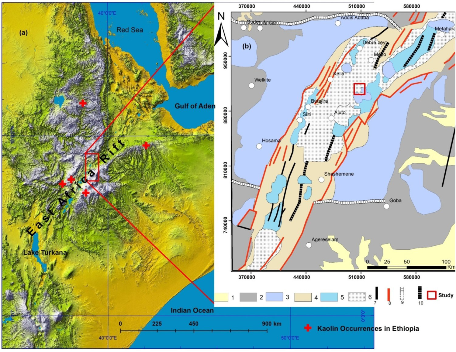
Regional geologic and tectonic setting
The MER connects two old rift segments of the EARS – the Oligocene–Miocene Red Sea rift in the north, and the early Miocene Turkana rift in the south (Corti 2009). The MER is the least evolved of the three arms of the triple junction, and it is ∼18Ma younger than the Gulf of Aden and Red Sea rifts (Wolfenden et al. 2004).
According to Ephrem (2010) and Kazmin and Seifemichael (1978), the geology of the MER is grouped into three lithostratigraphic sequences: pre-rift, syn-rift and main rift sequences. The pre-rift units are constituted by Precambrian metamorphic, Mesozoic sedimentary and Oligocene to Late Miocene plateau flood basalts. The syn-rift units are Upper Miocene-Quaternary volcanics constituted by Nazret pyroclastic rocks of welded to partially welded pyroclastic flows and rhyolitic and trachytic lava domes. Syn-rift volcanism has bimodal character with predominant acid products and associated basalts. These units have an age of 8 Ma years (Weldegabriel et al. 1990). Main rift units comprise Quaternary-Holocene young central volcanoes, basaltic and obsidian lava flows, trachyte, rhyolitic domes, and pyroclastic flow and fall deposits. Pyroclastic and pumice fall deposits of Bora-Bericha group in which the current study area is situated is related to the main rift units.
Structurally, in addition to the N–S trending major boundary faults, there are numerous E–W to ENE–WSW and NW–SE oriented transverse faults. The Yerer-tuluwelel volcano-tectonic lineament (YTVL) and Goba-Bonga lineament are the major E-W transverse lineaments (Bekele et al. 2007; Figure 1).
Methods and materials
Field geology
Field geology was conducted for the purpose of geological mapping, describing lithological units, collecting structural data and samples for laboratory analysis. Chip samples of potential parent rocks were collected for mineralogical and geochemical analyses. Random sampling of fresh kaolin was conducted from places where kaolinisation is dominant. Samples were collected from the wall of 3–4 m deep test pits using a geological hammer. All samples of nearly 1 kg weight each were labelled and put into plastic bags for subsequent laboratory investigation. Geological map of the deposit is also prepared at a scale of 1:25, 000.
Laboratory analysis
Petrographical, mineralogical, geochemical, and physical tests are the main laboratory methods used for the current study. Five kaolin samples were analysed using X-Ray Diffraction (XRD) method to determine the type and amount of minerals present in the deposit. Samples were dried, milled and sieved to different size classes. Kaolin samples of 30 grams of less than 2-μm size fractions were sent to the Geological Survey of Japan for quantitative and qualitative mineralogical analysis. Quantitative mineralogical determination of kaolin is done based on TG-DTA methods. This method operates based on the change in the physical properties of a substance subjected to a controlled temperature. Thermo Gravimeter (TG) is used to measure a variation in mass by either gain or loss at controlled environment. Differential Thermal Analysis (DTA) is a technique used for measuring the difference in temperature between a sample and a reference material. Kaolinite contents were calculated based on 13.9% of crystal water (weight loss between 450°C and 650°C). Moreover, five thin sections of parent rocks were prepared for petrographic examination.
A total of nine samples, four rocks and five kaolin samples were sent to Australian Laboratory Services (ALS) in Ireland for major and trace element analysis using Inductively Coupled Plasma Atomic Emission Spectroscopy (ICP-AES) and Inductively Coupled Plasma Mass Spectrometry (ICP-MS) respectively. Moreover, five kaolin samples were selected for physical tests and determination of technological properties (grain size, colour, specific gravity, and dry density).
Results
Geology of the kaolin deposit
The geology of the deposit consists of pumice, rhyolitic tuff, rhyolite, and trachy-andesite (Figure 2).
Geological map (a) and Geological cross section along A-B (b) of the study area.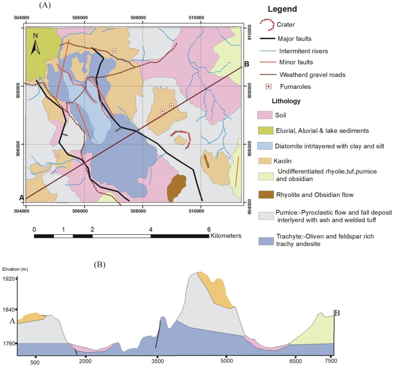
Pumice is the most abundant lithological unit in the study area. It forms small hills and deep gullies. The fresh part of it is grey to light bluish in colour while the weathered part is whitish, yellowish, and pinkish to reddish.
The other unit is unwelded tuff. It is exposed in different parts of the study area. However, frequent inter-layering with other units (notably pumice) makes it unmappable. Tuffs are found as interlayers within pumice, rhyolite and obsidian flows. This unit has light greenish to yellowish grey colour and fine to medium-grained texture with some visible lithic fragments. At places, the colour changes from grey to light greenish. Some part of it is highly weathered and changed to kaolin. Thin section analysis of the rock showed spherulitic and hypocrystalline textures. Quartz, sanidine, and volcanic glass are the dominant components observed under the microscope. Accessories of olivine, biotite, pyroxene and ground mass of plagioclase and other fine-grained minerals are also present.
The rhyolite has aphanitic to porphyritic (with phenocrysts of quartz, orthoclase, biotite) texture and is found as small ridges and hills. It is light to light grey and finely flow-banded. In most places it is found inter-layered with pumice and obsidian flows. This lithological unit is partly to wholly kaolinised.
The trachy-andesite forms isolated small hills and elongated ridges. It is exposed in central and north-western parts of the study area. The fresh part of the trachy-andesite is massive, light grey to black while the weathered part shows light reddish to greenish colour. Microscopic observations show that it is composed of phenocrysts of euhedral to subhedral quartz, plagioclase, pyroxene, sanidine and minor amount of olivine and opaque. Vesicles are sometimes filled by quartz, calcite, kaolin and other clay minerals.
The kaolin deposit of the area is related to the above acidic volcanic rocks of pumice, tuffs, rhyolite and trachy-andesites (Figure 3). Based on the topography, the extent of the deposits and simplicity for mapping and reserve estimation, the kaolin deposit of the area is divided into five blocks. These are Lugo, Werdi, Didibso, Boka and Tero blocks. The occurrence and distribution of the deposit is related to the intensity of weathering which is found to be high around faults, fractures and other weak zones. These structures are the ones which facilitated the downward movement of meteoric water and subsequent alteration of the tuff and pumice intercalation into kaolin. The deposit occurs as an irregularly shaped patch (blanket) of kaolin. The thickness of the kaolin deposit varies from about 4 m (Didibso block) to 11 m (Tero block). The deposit is found exposed or covered by overburden of up to about 2 m.
Kaolin exposures and section views of Werdi (a, d); Lugo (b); Didibso (c, e); and Lugo (f) sites.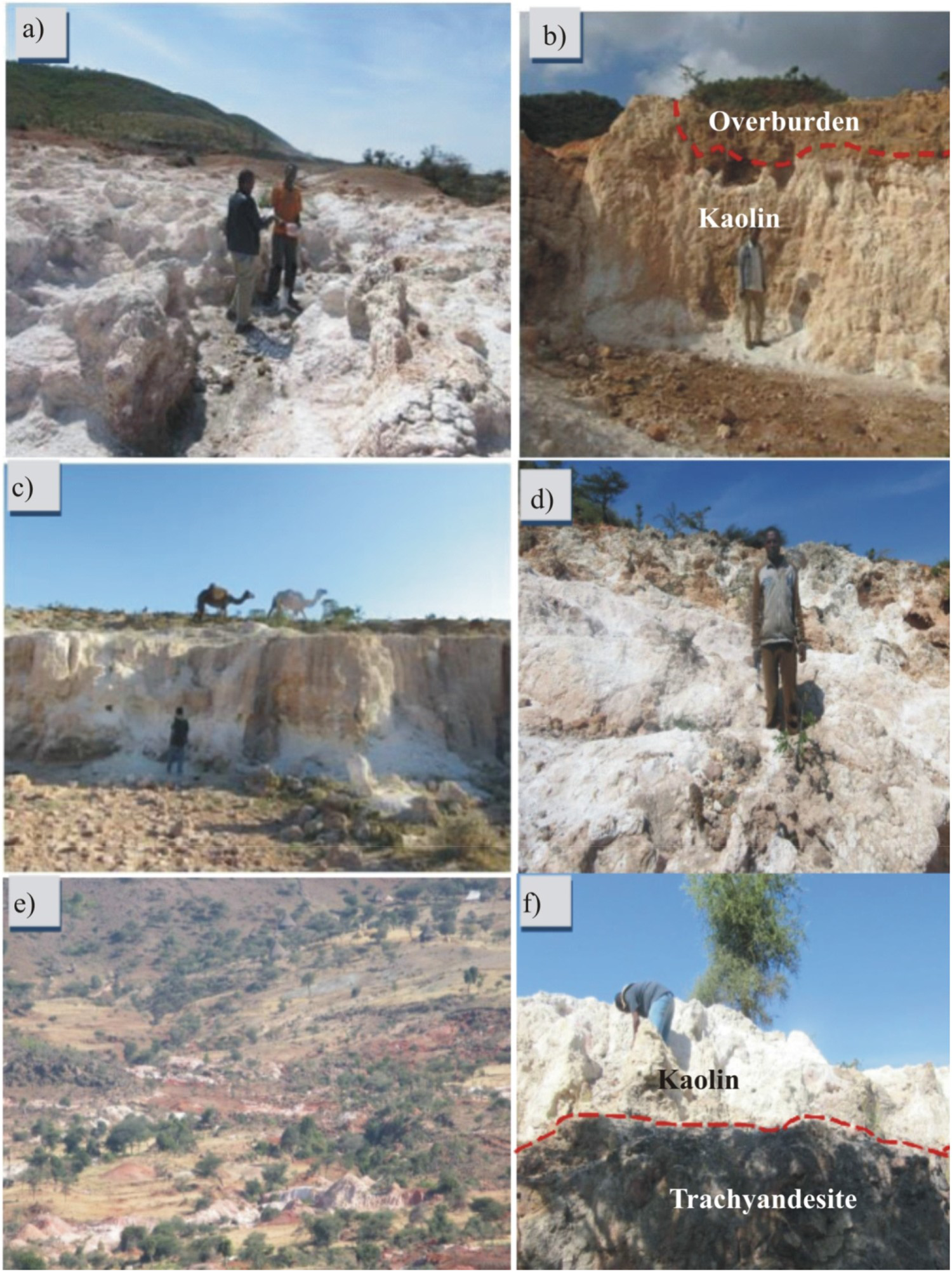
Didibso kaolin covers the central and northern part of the study area. The kaolin deposit is found associated with pumice, tuff and trachy-andesites. It forms small hills and deep gullies. The kaolin deposit of this site covers wide area and most of it is exposed on the surface. As inferred from geological cross section and field relationships, the kaolin deposit of this site is formed by alteration of pumices and intercalated tuff and rhyolite units. The colour of the kaolin is white to dull grey with some reddish stains.
Werdi kaolin is located in the central part of the area. It is the largest deposit in Alemtena area. It is related mainly to the unwelded tuffs. It occupies the peak of Werdi mountain as a result of which it is eroded and filled deep gullies.
Lugo kaolin covers the north-western part along the Lugo Graben. It is associated with tuff, pumice, rhyolite and in some parts with trachy-andesite where the later unit shows kaolinisation mainly along weak zones (fractures and faults). The deposit is frequently affected by mass movement.
Boka kaolin is located in the south-western part of the study area. It is related to in situ alteration of pumice and tuff with some rhyolite units. Boka kaolin is found at the peak of Jima mountain. This kaolin deposit is the best quality. However, it has the lowest reserve with relatively thick soil overburden.
Tero kaolin is found in the south-eastern part of the study area and is exposed along deep gullies, river gorges, ridges and hills. It is the result of alteration of pumice with minor contribution from tuff and rhyolite.
Mineralogy of the kaolin deposit
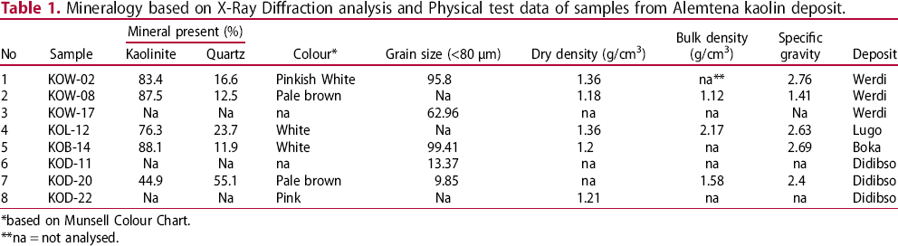
The mineralogical composition of the deposit is given in Table 1. The quantitative XRD analysis result indicates that kaolinite is the dominant mineral with considerable amount of quartz (Table 1, Figure 4). The average kaolinite content is 76% for the whole deposit while the highest content (88%) is from Boka and the lowest is for Didibso block. The XRD patterns of Alemtena kaolin are characterised by sharp diffraction peaks (Figure 4). Kaolinite with high structural defect is expected to have broad peaks (Murray 2007). The XRD peaks are also related to the degree of weathering in such a way that as intensity of weathering increases, the sharpness of peaks increases (Duzgoren-Aydin 2002). The order–disorder of kaolin is also determined from the crystalline index of kaolin using Hinckley Index (HI). The HI is calculated from the diffraction peak in the 2θ region of 20–23° (Hinckley 1963). The HI of Alemtena kaolin ranges from 0.8 to 1.37 and indicates that all of the samples are well crystalline, which is also demonstrated by the sharp picks of the diffraction patterns.
XRD patterns of selected samples from Alemtena Kaolin samples. Mineralogy based on X-Ray Diffraction analysis and Physical test data of samples from Alemtena kaolin deposit. *based on Munsell Colour Chart. **na = not analysed.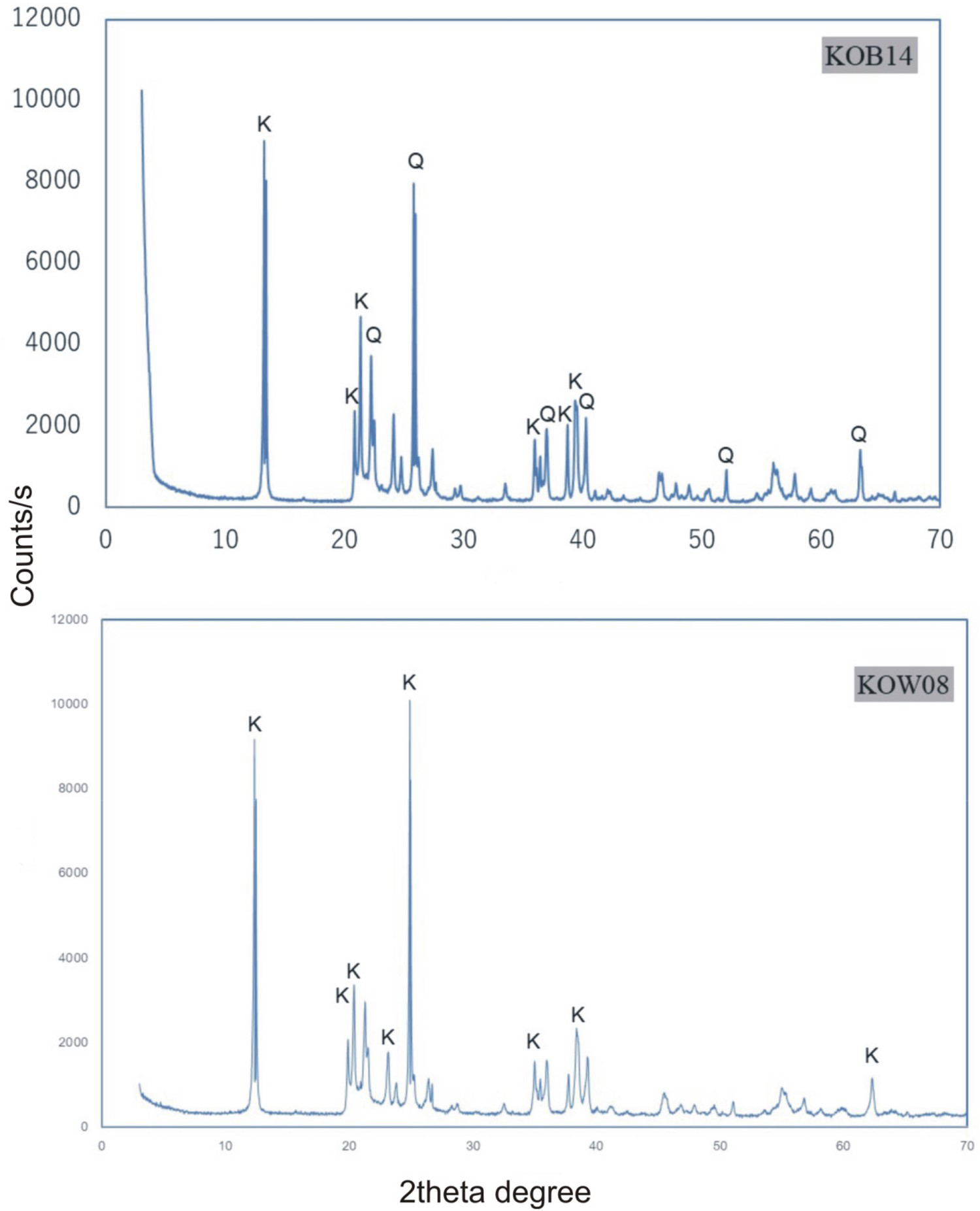
Geochemistry
Major, trace element and REE composition of rocks and kaolin samples from Alemtena kaolin deposit.
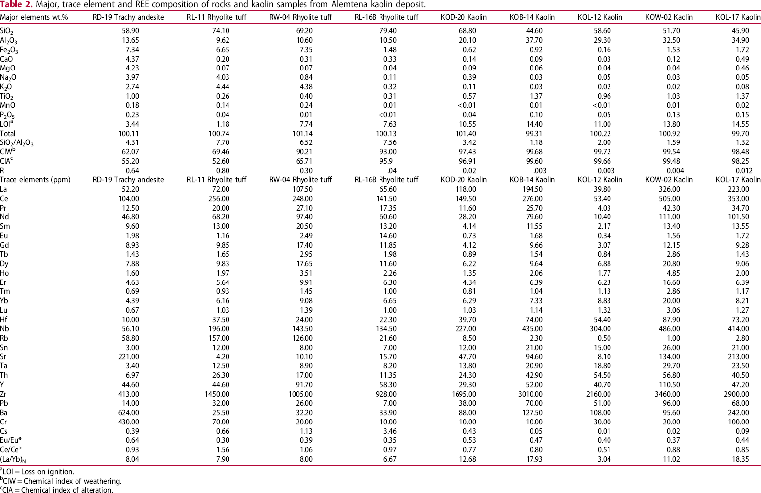
aLOI = Loss on ignition.
bCIW = Chemical index of weathering.
cCIA = Chemical index of alteration.
Major and trace element geochemistry
The SiO2 concentration of the fresh rocks ranges from 58.9% to 79.4% and is within the range of intermediate to acidic composition (Le Bas et al. 1986). Therefore, chemically one sample is trachy-andesite while the other three are classified as rhyolite.
Most of the major elements are concentrated in the parent rocks except Al and Ti which show strong positive correlation between them (Figure 5) demonstrating their immobility during alteration of volcanic rocks (Hong et al. 2019). All other major elements including iron have been mobilised and show negative correlation with Al (Figure 5). Since the mobility of Fe during weathering is a function of Eh-pH conditions (Middelburg et al. 1988), it can be assumed that acidic and reducing condition might have facilitated the removal of Fe from the weathered profile. It is notable that the linear regression line for both positively and negatively correlated elements with Al connects the rhyolitic tuff and the kaolin samples (Figure 5) suggesting a genetic link between the tuff and the kaolin deposit.
Variation diagram of Al2O3vs. selected major and trace elements from Alemtena Kaolin deposit.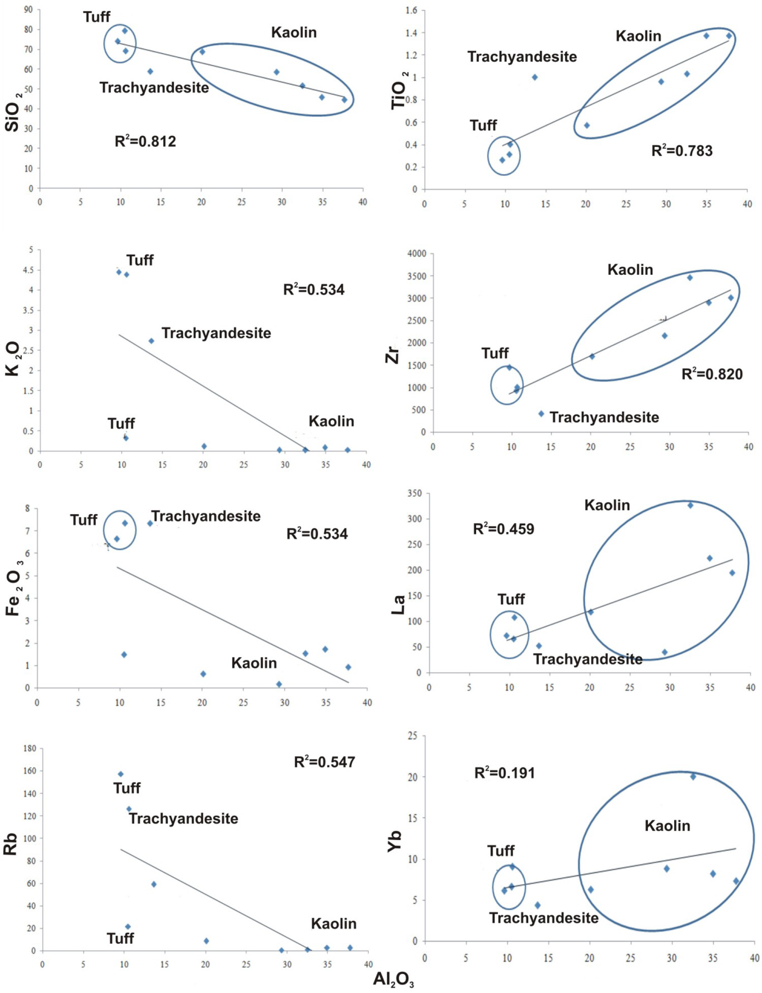
The chondrite normalised REE diagram of both rock and kaolin samples shows negative Eu and slight to none Ce anomalies (Figure 6(a)). The negative Eu anomalies are evident both in the kaolin and surrounding rocks. However, the kaolin deposit shows strong negative Eu anomaly compared to that of parent rocks (Figure 6(a), Table 2) which may be related to the breakdown and subsequent removal of feldspars during weathering. The diagram also indicates enrichment of LREE and flat pattern of HREE. The ratio of LREE/HREE as evaluated by (La/Yb)N shows that the kaolin is more enriched in LREE (average (La/Yb)N = 12.60) than fresh rocks (average (La/Yb)N = 7.65) suggesting fractionation of REE during alteration.
Chondrite normalised REE variation diagram (a); multi-element variation diagram (b) (Chondrite values from McDonough and Sun 1995), grain size distribution (c), and paleo-environment (d) of Alemtena Kaolin.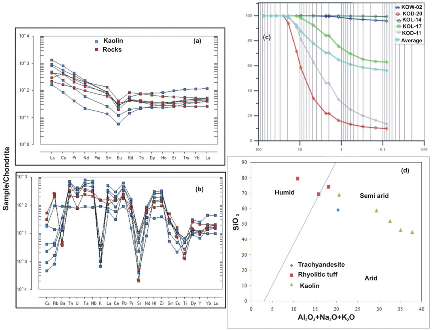
The multi element variation diagram (Figure 6(b)) shows depletion of the mobile Large Ion Lithophile (LIL) elements (K, Cs, Rb) and enrichment of less mobile high field strength (HFS) elements (Th, Ta, Hf, Nb, Y, Zr). Potassium, Cs and the likes are leached along with Rb during weathering due to the decomposition of feldspar rich parent rocks during alteration (Abedini and Calagari 2016).
Physical properties
Most of the samples from Alemtena kaolin deposit have white colour (corresponding to N9 in the Munsell soil chart). Some kaolin samples show pale brown (10YR 8/2) and pink (7.5Y 8/3) colours. Besides colour, particle size distributions are the main physical parameters that control the commercial viability of kaolin deposits (Prasad et al. 1991; Bloodworth et al. 1993). More than 70% of the samples from Alemtena kaolin deposit have an average size fraction of less than 2 mm (Figure 6(c)). The average bulk density of Alemtena kaolin is 1.62 g/cm3, which can be considered as low bulk density kaolin. The average specific gravity value of Alemtena kaolin is 2.38, which is within the range of the theoretical value of kaolin (2.16–2.68).
Discussions
Genesis
Kaolin deposits are formed mainly either by hydrothermal (hypogene) or weathering (supergene) processes (Ekosse 2010; Murray 1999). Identification of the process of formation for a given kaolin deposit requires investigation and integration of field geological observations, mineralogical, geochemical and physical test data (Erkoyun and Kadir 2011; Simeone et al. 2005 and others).
A number of authors (e.g. Abedini and Calagari 2016; Marfil et al. 2005; Dill et al. 1997) used binary and ternary plots of different trace and rare earth elements combinations to determine hypogene and supergene kaolin formation. Dill et al. (1997) used binary plot of Ba + Sr vs. Ce + Y+La, TiO2 vs. Zr, Cr + Nb vs TiO2+Fe2O3 and Ternary plot of Pb, Ba + Sr and Ce + Y+La. Accordingly, TiO2+Fe2O3>1 wt-%, Cr + Nb>100 ppm, Ba + Sr<1000 ppm and Ce + Y+La>100 ppm are related to supergene origin. Samples from Alemtena kaolin deposit are plotted within the supergene field in all cases (Figure 7(a–c)).
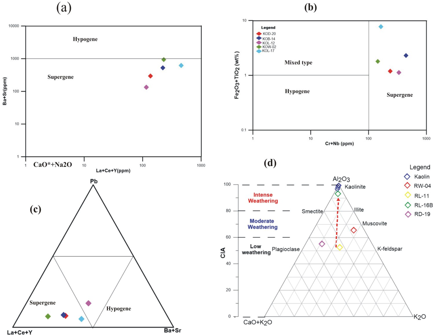
Discrimination of the formation process and parent rocks of kaolin is also deduced from the enrichment and/or depletion of certain minerals, the different physical properties and crystallinity of kaolinite. Kaolin deposits related to supergene process have relatively low bulk densities (<2.0) (Ismail et al. 2014). The bulk density of Alemtena kaolin is 1.62 g/cm3 and indicates supergene origin. The absence of high temperature minerals like dickite, pyrophyllite, pyrite, etc. also suggests that Alemtena kaolin is a supergene origin. Ma (1996) and Tsolis-Katagas and Mavronichi (1989) stated that the crystallinity index of kaolin formed by supergene origin is higher than that of hydrothermal origin. The HI of Alemtena kaolin ranges from 0.8 to 1.37 which falls within the range of low defect and well crystalline kaolin (0.9–1.15).
The degree of weathering is one of the most significant factors controlling the type and abundance of clay minerals (Duzgoren-Aydin and Aydin 2003). It is estimated using the indices called Chemical Index of Weathering (CIW), Chemical Index of Alteration (CIA) and the ratio R. The formulae used to calculate these indices are: R = (CaO + Na2O + K2O)/(Al2O3+L.O.I) (Middelburg et al. 1988), CIA = [(Al2O3)/ (Al2O3+CaO*+Na2O + K2O)]×100 (Nesbitt and Young 1989), CIW = (Al2O3)/ (Al2O3+CaO*+Na2O)×100 (Harnois 1988). CaO* is the amount of CaO in silicate fraction and is calculated as CaO* = molCaO – [(10/3) × mol P2O5]. In this context higher value for CIA and CIW and low value of R (which is the measure of degree of feldspar breakdown) indicate high degree of alteration by weathering (Middelburg et al. 1988). CIA values between 85% and 100% are considered to be typical of residual soils (McLennan and Taylor 1991). The CIA value of Alemtena kaolin is within the ranges of 98.3–99.7 (Table 2) and this strengthens the supergene origin of the kaolin deposit. All of the indices calculated for Alemtena kaolin indicate intensive weathering. This condition might be facilitated because of the semi-arid paleo-environmental conditions (Figure 6(d)) which favoured intermittent dry spells followed by rainfall, porous nature of the unwelded tuff and the frequent fracturing in the continental rift setting.
Weathering is characterised by the loss of Si, Ca, Na and K, and by gain of Al, Ti, Zr and LOI (Duzgoren-Aydin and Aydin 2003). The predominant elements of Alemtena kaolin are SiO2 and Al2O3 with SiO2/Al2O3 ranging from 1.80 to 2.22. This ratio decreases from the fresh rocks to the kaolin due to release of silica during weathering which is evident by significant negative correlation between the two (Figure 5). Moreover, the LOI of the Alemtena kaolin ranges from 10.55% to 14.55% (average 12.86) that is close to the LOI value of the world known kaolin deposits such as Georgia (13) and Cornwall (13.6) (Ekosse 2001).
The A(Al2O3)–CN(CaO + Na2O)–K(K2O) diagram has been used by many researchers to show the degree of alteration by weathering and the possible genetic link between fresh rocks and kaolin deposits (e.g. Shao et al. 2012). The triangular diagram for the study area (Figure 7(d)) shows that the Alemtena kaolin deposit fall very close to the Al2O3 peak of the triangle indicating intensive weathering. The presumed weathering trend shown as red arrow in Figure 7(d) passes between samples RD-19 (trachy-andesite) and RL-11 (rhyolitic tuff). However, the weathering trend line is very close to the rhyolitic tuff. Therefore, the most probable source rock for the kaolin deposit is tuff. This is evident from field observations where many of the kaolin occurrences are found associated with unwelded tuffs.
Grade and quality of kaolin
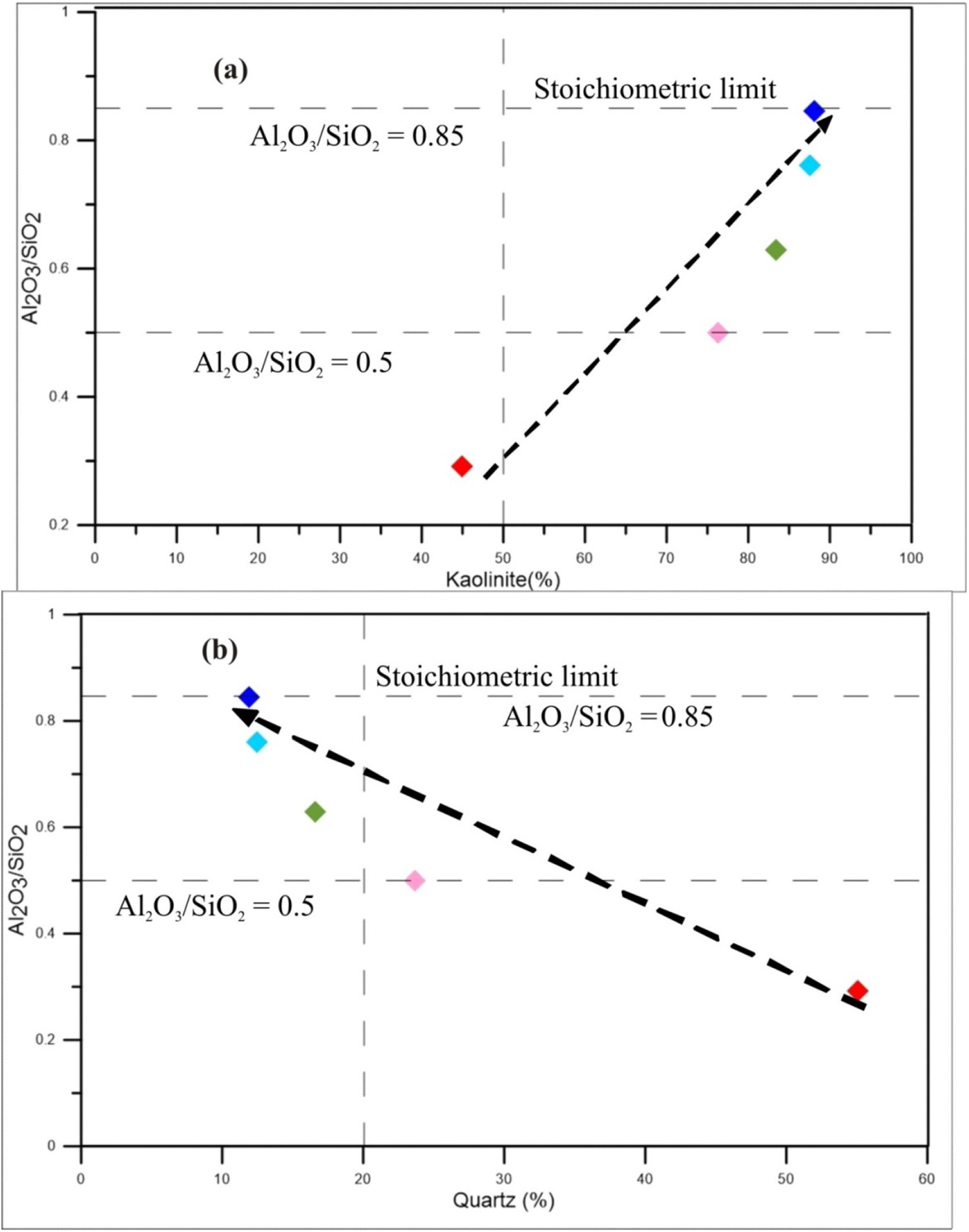
The total amount of kaolinite plays a significant role on the grade of kaolin (Ekosse 2001). Kaolin deposits containing >75% kaolinite are considered as high grade (Awad et al. 2018). Most of the Alemtena kaolin deposit contains >75% kaolinite and hence can be classified as high grade (Table 1, Figure 8). The kaolinite content increases from the lowest kaolinite limit Al2O3/SiO2 = 0.5 (sample KOL-12) and kaolinite = 76.3% up to Al2O3/SiO2 = 0.845 and kaolinite = 88.1% (sample KOB-14). The only kaolin sample with lower grade (Al2O3/SiO2 = 0.29) is sample KOD-20 from Didibso block.
When we consider grain size as quality requirement, most of the analysed samples contain appreciable amount of fine size fraction (<80 µm), especially samples collected from Boka and Werdi sites are dominantly (>90%) constituted by fine fractions (Table 1 and Figure 6). However, further grain size analyses is required to determine the exact amount of the <2 µm fraction, which is the ultimate determinant for the quality of a kaolin deposit. The quality of Almetena kaolin deposit with respect to colour is also considerably high. As determined by the Munsell colour chart, three out six of the tested samples have white colour. Since the Fe content (which causes the non-whiteness) is very low (average value for kaolin samples 0.99% Fe2O3, Table 2), the colour can be enhanced through physical (crushing and calcining) or chemical (conventional leaching process using different chemical agents like oxalic acids which dissolves iron and lower the Fe content) beneficiation methods.
The quality of kaolin is also determined by the type and amount of impurities. Generally, impurities are found either adhering to the surface area of kaolinite or by substitution of an element into the kaolinite structure (Ekosse 2001). The common impurity minerals occurring with kaolin include feldspar, mica, quartz, ferruginous, titaniferrous and carbonaceous materials. The Fe and Ti bearing minerals play an important role in determining the quality of the kaolin, as these elements render yellow, pink or darker colour to the white kaolin (Kulkarni and Jadhav 2016). The average Fe2O3 and TiO2 concentration of Alemtena kaolin is relatively low (Table 2) and meets the requirement for the paper coating and filler industries. Besides, the absence of soluble salts, exchangeable ions and other accessory minerals make this deposit high quality.
The overall quality of kaolin deposits is enhanced through ore beneficiation methods. However, different end uses need different quality of kaolin and hence recommending a specific method of processing for a given deposit may not be practical. However, from economical and technical limitations prevalent in the developing world which is required by the wet beneficiation process, the dry process method is feasible for the Alemtena kaolin deposit. Even if the dry process produces low quality product, the relatively better natural quality (whiteness, high grade and high percentage fine fraction) of the Alemtena kaolin deposit warrants the use of the dry process method to obtain high quality kaolinite concentrate.
Economic importance
The economic significance of kaolin deposits depends, in addition to quantity, on the physical, mineralogical and chemical properties of kaolin. Color, grain size, kaolinite percent and the amount and type of impurities are the main parameters controlling the suitability of kaolin (Prasad et al. 1991; Conceição et al. 2005 and others). The data collected on Alemtena kaolin indicate that it is suitable for various industrial applications. The kaolinite content of Alemtena kaolin falls within the range of chemical compositions required for ceramics industries (81–93% kaolinite; Bloodworth et al. 1993). Moreover, the Al2O3 concentrations of Alemtena kaolin fulfills the specification for agriculture, pharmaceutical, textile, brick clay, refractory brick, paper coating and filler industries. However, the concentration of Fe2O3 and TiO2 need some quality enhancement.
As far as the reserve of the deposit is concerned, a total of nearly 85 million tons of probable reserve is calculated. A stripping ratio of 1:1 for Tero site to 1:7 for the Didibso site indicates the variable economic feasibility of the different blocks.
Conclusions
The field geological, geochemical, mineralogical and physical test data revealed that the rift volcanics especially the rhyolitic tuff have undergone intensive weathering and formed the kaolin deposit. The unwelded nature of the tuffs, the frequent faulting and fracturing in the rift environment, the natural susceptibility of volcanic rocks to weathering and the semi-arid paleo-environment that permitted intermittent dry spells might have facilitated the rapid weathering of the rift volcanics into kaolin.
The mineralogical, geochemical and physical test result confirms the supergene origin of Alemtena kaolin deposit. Specific evidences for supergene origin include:
The only presence of kaolinite and quartz, and absence of high temperature minerals like pyrophyllite, diaspor, dickite, nacrite and pyrite, The presence of high crystalline order kaolinite (HI > 0.9), Elevated concentration of Cr + Nb, Ce + Y+La and low concentration of Ba + Sr, and The relatively low bulk densities with high CIW (98.5–99.7) and CIA (98.3–99.7).
The mineralogical, chemical and other physical test data indicate that the kaolin deposit is suitable for paper, ceramic, pigment, agricultural, pharmaceutical and other industrial applications. However, the presence of Fe2O3 and TiO2 impurities makes it undesirable for certain applications unless a well-designed quality enhancement is conducted. As such dry process methodology is recommended because of its simplicity and cost effectiveness. The relatively good quality and high grade (kaolinite > 75%), considerable amount of reserve and allowable strip ratio of the kaolin deposit warrants mining and developing of the resource at a reasonably low investment cost.
Finally, as there is extensive occurrence of acidic to intermediate volcanic rocks in the Ethiopian Rift, and since this and other studies confirmed that a relatively rapid rate of weathering was possible in the past geological time, further exploration for industrial minerals in the rift can discover additional kaolin occurrences.
Footnotes
Acknowledgements
Addis Ababa University and Geological Survey of Ethiopia provided logistic and financial support for the research. The authors would like to thank Dr. Tetsuichi Takagi of Geological Survey of Japan and Dr. Roy Kuda of AIST for the XRD analysis. We also thank the journal editor, Dr Simon Jowitt and the two anonymous reviewers for the valuable comments and inputs which improved the overall quality of the article.
Disclosure statement
No potential conflict of interest was reported by the author(s).