
Abstract
A reassessment of the geochemistry of stream sediments collected by the British-led North Sumatra Project from 1975 to 1980 in central Aceh with spectrum–area and local singularity fractal techniques refines previously determined areas with anomalous Cu and delineates As anomalies (proxy for Au) that correspond to porphyry Cu and epithermal Au–Ag deposits and prospects discovered in the 1980s and 1990s. Additionally, the application of these methods to stream sediment samples collected by an Australian company in the mid-1990s from part of central Aceh identifies Au, As, and Cu anomalies that are aligned with regional geochemical trends. Integrating singularity metal-enriched areas and the distribution of mineral occurrences and structures reveals northerly and easterly tectono-magmatic corridors controlling epithermal Au–Ag and porphyry Cu mineralisation. The above results attest to the usefulness of legacy data for first-pass mineral assessments and for providing evidence layers for a future mineral prospectivity map.
Keywords
Introduction and previous studies
For decades, the province of Aceh in northern Sumatra (Figure 1) has been known to be rich in natural resources (e.g. van Bemmelen 1970). With the waning exploitation of alluvial platinum and gold deposits on the western embayment in the mid-1980s, attention has shifted to the search for primary ore deposits on higher ground. From 1975 to 1980, the joint British-Indonesian North Sumatra Project (NSP) launched regional geochemical reconnaissance and geological mapping programs in Aceh. The results led to the discovery of several porphyry Cu deposits and prospects in the 1980s and early 1990s (van Leeuwen 2014). By the mid-1990s, exploration by various major and junior international resource corporations (Figure 1(b)) advanced some of the prospects for deposits.
(a) Index map of Aceh on Sumatra Island. (b) Tenement map of Aceh as at the mid-1990s with some of the international companies (after van Leeuwen 1994, 2014); Highlands Pacific held the Tripa tenement (south block). Also plotted are Peuet Sague volcano (red triangle) and Daling pluton (red rectangle) for references throughout the paper. (c) Copper and Pb ranking areas (0.5 and above) defined by Page and Young (1981) and locations of Cu, Au, and Pb occurrences (deposits, prospects, showings; compiled from various sources for this study). Miwah (red diamond) is a high-sulfidation epithermal Au–Ag deposit, while the others are either high-, intermediate,- or low-sulfidation epithermal system. Exploration is reportedly not permitted in the Leuser ecosystem region where Daling pluton is located significantly evolved from the classical method of mean plus twice the standard deviation.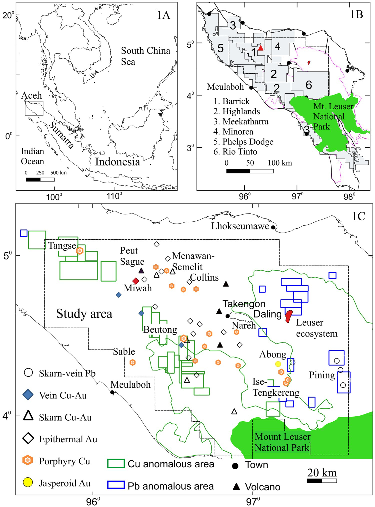
Although the NSP data and their assessments are credited with the above discoveries, only partial results were published in a peer-reviewed journal article by Page and Young (1981); to the best of our knowledge, no other study is available in the public domain. Sixteen elements, namely, Ag, Cu, Pb, Zn, As, Co, Ni, Cr, Sn, Mo, W, V, Hg, Li, K, and Mn, were measured in stream sediment samples, but only Cu, Pb, Cr, Li, and Sn were evaluated in terms of mineral potential in Sumatra north of 4°N. The authors considered the threshold for these elements to be the top 3% of the geochemical distribution or the mean plus two standard deviations and ranked the anomalies per 10 × 10 km2 cell with the formula R = ɑ2/N, where R is the ranking score (0 to over 1.5), ɑ is the number of anomalies, and N is the number of samples. These estimates produced a series of NW-trending areas with anomalous Cu along which the Tangse porphyry Cu–Mo (600 Mt at 0.05–0.2% Cu and 50–150 ppm Mo; van Leeuwen et al. 1987) and Beutong Cu–Au–Ag–Mo (509 Mt at 0.48% Cu, 0.13 g t−1 Au, 1.28 g t−1 Ag, and 120 ppm Mo; Hackman 2014) deposits and four porphyry Cu–Au prospects were discovered (Figure 1(c)). However, the areas with 0 rankings were subsequently proven in the 1990s and 2000s to host the Miwah high-sulfidation epithermal deposit (3.13 Moz Au; Taylor 2011), the Abong jasperoid Au deposit (8.5 Mt at 1.5 g t−1 Au and 10.7 g t−1 Ag; Taylor 2012), and other drilled porphyry Cu and epithermal Au–Ag prospects.
The issue with the areas geochemically ranked 0 probably lies in the aforementioned method of separating anomalies from background values. Methods of defining geochemical anomalies have evolved from the classical technique of mean plus twice the standard deviation (Hawkes and Webb 1962) through the probability plot approach (Sinclair 1974), univariate and multivariate statistical analysis (Davis 2002 and references therein), and spatial geostatistical methods to fractal/multifractal modelling (Cheng et al. 1994, 2000) (cf. Zuo et al. 2021). Generally, the above methods address the fundamental shortcomings in their predecessors. For instance, the first three frequency-based methods do not consider the spatial influence on the concentration values of the elements in the sample media (Zuo and Wang 2016). Two of the widely used geostatistical methods, namely, inverse distance weighting or IDW (Shepard 1968) and kriging interpolations (Krige 1966), predict the values of unknown locations based on the values and distances of their nearest neighbours. In the former method, the estimated value is weighted by the inverse of their distances and power setting (arbitrarily set, normally 1 or 2), whereas in the latter approach, the estimated value is based on a stochastic model of continuous spatial variation by taking into account knowledge of the spatial variation as represented in the variogram or covariance (Oliver and Webster 2015). For the mathematical expressions of these two techniques, interested readers can consult geostatistics textbooks such as Sinclair and Blackwell (2002). The IDW and kriging interpolations, however, have limitations in dealing with extensive overlapping anomalous and background values and do not consider that the spatial variability is irregular and singular rather than smooth and differentiable (Cheng 2007; Zuo and Wang 2016).
In contrast to the aforementioned techniques, fractal/multifractal modelling integrates both spectral and spatial attributes of geochemical data to separate anomalies from background values (Cheng et al. 2000). Among several approaches in this modelling (see Sadeghi 2021; Zuo et al. 2021), the spectrum–area (S–A; Cheng et al. 2000) and local singularity (L–S; Cheng 2007) fractal methods have become the dominant methodology in the majority of geochemical exploration literature. Building on the power law-based concentration–area (C–A) method, the S–A and singularity methods are mutually complementary in processing geochemical data from complex geological terrains such as central Aceh. In addition to decomposing geochemical data into anomalous and background values, the S–A method, which defines the spectral energy density–area relationship in the frequency domain, can detect weak anomalies that may be bypassed by the C–A method (Cheng et al. 2000) and relate different geochemical frequencies to particular geological features (Wang et al. 2017). On the other hand, a singularity, which is defined as a special phenomenon with anomalous energy release or material accumulation occurring within a narrow spatial–temporal interval (Cheng 2007), is sensitive to minor changes in these element concentrations, thereby enhancing the detection of weak geochemical anomalies. Moreover, the singularity approach can quantify elemental enrichments and depletions caused by mineralisation (Zuo et al. 2013), vector mineral occurrences and predict geological processes (Wang et al. 2017). Another crucial characteristic of fractal methods is that elemental outliers have no effect on the outcomes (e.g. Luz et al. 2014). Consequently, legacy data have been reassessed with these techniques, which, in many cases, has revealed new target areas (e.g. Yilmaz et al. 2019; Gonçalves and Mateus 2019; Wang and Zuo 2020).
The purpose of this paper is to apply the spectrum–area (S–A) and local singularity (L–S) fractal methods to the geochemistry of stream sediments from the NSP for central Aceh and from a segment of this region sampled by an Australian company in the mid-1990s with the objectives of determining whether fractal-generated anomalies correspond spatially to all known primary Cu and Au deposits in central Aceh and of locating new exploration targets. Moreover, these results are combined with more recent, previously unpublished reports on mineral occurrences and the geology of central Aceh to shed light on mineralisation-controlling structures. There are two major advantages of using central Aceh as a case study: (1) the absence of mining activities in the investigated region during the field work so that no anthropogenic contamination of the samples occurred and (2) the availability of geological, petrochemical, and geophysical information on some of the deposits to help in the interpretation of fractal anomalies.
Geology and mineralisation
Sumatra (Figure 2) lies in a collisional zone where the Indo-Australian oceanic plate has been obliquely subducted beneath the Sunda craton since the middle Eocene (50–40 Ma; Hall 2012). This setting marks the culmination of protracted geological evolution from the breakup of Gondwanaland during the Permian to the successive migration of fragments and their amalgamation into the craton from the Triassic to the early Paleogene (Barber et al. 2005; Hall 2012). Each of the terranes was part of the Meso-Tethys oceanic crust that was subducted beneath proto-Sumatra. The latest plate convergence initiated the rise of the Barisan Mountains (‘Barisan’) between the late Mesozoic and early Paleogene (∼70 Ma; e.g. Barber and Crow 2005), the Sumatran Fault System (SFS) during the middle Miocene (20–10 Ma; Fitch 1972; Sieh and Natawidjaja 2000), and extensive regional magmatism.
Geological map of central Aceh (compiled from Bennett et al. 1981a, 1981b; Cameron et al. 1982a, 1982b, 1983; Mulja et al. 2020). Additional structures were interpreted from 30-m digital elevation data download in 2021 from the United States Geological Survey. Solid/blank triangle: active/dormant or extinct volcano. In the Inset map, the Bentong–Raub line marks the paleo-southwestern margin of Eurasian craton to which the Sibumasu terrane from the west was amalgamated (Hutchison 2014). The off shore fracture zones are after Milsom and Walker (2005). SFS: Sumatran Fault System.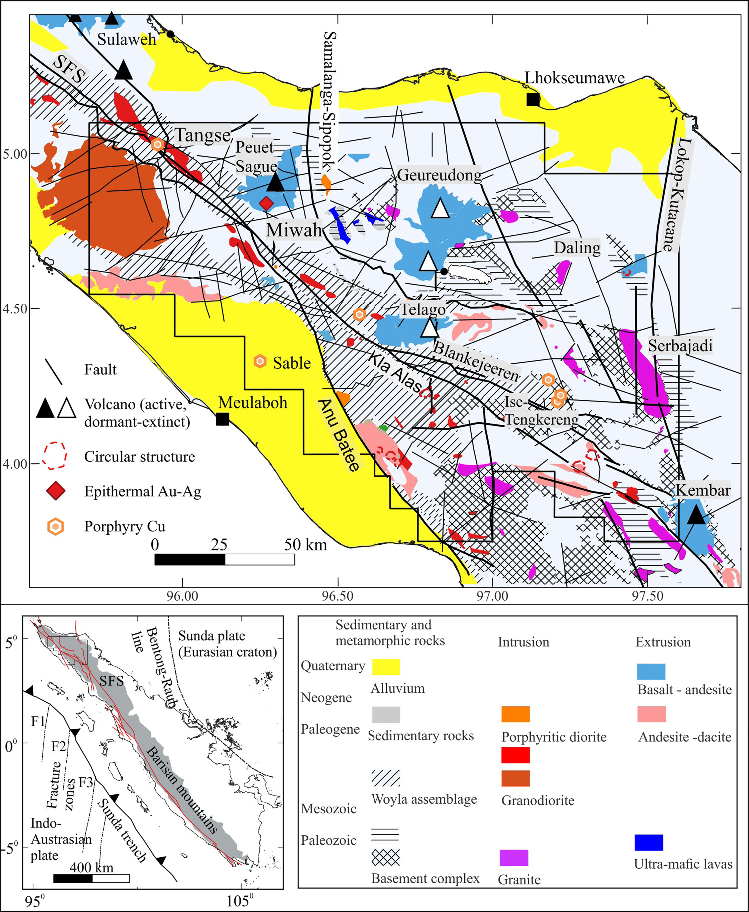
In central Aceh, Carboniferous–Triassic basement schists and phyllites with subordinate limestones, mafic lavas, and sandstones form the backbone of the Barisan (Figure 2). Thrust over these rocks is the Jurassic–Cretaceous Woyla oceanic assemblage (Barber 2000). Overlying these lithologic units on both sides of the Barisan are Paleogene–Neogene sedimentary packages, which were deposited following horst and graben development and cyclic marine transgression and regression events. Magmatism was widespread, but its isotopic ages are sparse. Northwest-trending late Paleozoic–Mesozoic granites to diorites in the east bifurcate to the west in the south. Among these intrusions, the largely unaltered Serbajadi batholith and Doson pluton are proximal to the former Pb + Zn (± Cu) skarn and vein deposits hosted in the basement slates (Bennett et al. 1981a; Cameron et al. 1983; Figure 2). In northwestern Aceh, the Cretaceous Sikuleh composite batholith (97.7 ± 7 Ma; Bennett et al. 1981a), which intruded into the Woyla assemblage, hosts porphyry-type Mo mineralisation (Bennett et al. 1981b). Coeval volcanism is minor in central Aceh. By contrast, the Late Cretaceous–Paleocene (80–56 Ma) granodiorites and diorites are aligned in the northwest direction in almost all of Aceh. However, some of those in the south trend N–S. Only base metal showings occur in these intrusions or adjacent rocks.
Building upon the basement rocks, the NW Oligocene to Miocene (28–5 Ma) volcanic arc in the east branches in a WNW direction. Its coeval intrusions follow a similar distribution pattern, and those in the east are associated with a cluster of at least four porphyry Cu–Au–Mo prospects (Upper and Lower Ise-Ise and Tengkereng, collectively referred to as the Ise-Tengkereng porphyry group), a jasperoid-hosted Au deposit in the southeast, and several porphyry + skarn Cu showings (Menawan and Semelit) in the northeast. On the western flank of Barisan, the Miocene Tangse porphyry Cu–Mo deposit (9–13 Ma; van Leeuwen et al. 1987) developed within the Late Cretaceous–Paleogene plutonic arc. From the Plio–Pleistocene to the present (<5 Ma), magmatism also trends NW and bifurcates to the east to form the short, north-facing arcuate Aceh arc. However, the Geureudong, Nama Salah, and Telago volcanic fields are aligned in an N–S direction, and this trend appears to continue southward, where a circular structure is interpreted as a volcanic centre. The main NW-trending arc hosts the Pliocene Beutong porphyry Cu–Au–Ag–Mo deposit (4–4.66 Ma; Hackman 2014) and the Plio–Pleistocene Miwah high-sulfidation epithermal Au–Ag deposit (inferred from the adjacent ∼2 Ma dacite dome; Williamson and Fleming 1995).
Pre-Paleogene structures are inadequately documented (Cameron et al. 1983). Based on the interpretation of airborne geophysical data, satellite images and geological maps, Etheridge-Henley-Williams (1997) concluded that at least E–W and N–S pre-Paleogene faults cut the region. The currently observed and interpreted structures (Figure 2) are mainly controlled by three compressional forces (Williamson and Fleming 1995). From the middle to late Miocene, the ‘Andaman Sea’ compression directed a 170° axis of maximum compressive stress σ1 to produce dextral (135°) and sinistral (20°) oriented structures. Following the 20° clockwise rotation of Sumatra during the late Cenozoic (Ninkovich 1976), the Pliocene-present ‘Andaman’ compression has a 140° σ1 with conjugate dextral (110°) and sinistral (170°) faults, while the ‘Sumatra’ compression with a 45° σ1 induces conjugate dextral (0°) and sinistral (30°) faults. The dextral SFS, which accommodates the Australian-Sunda plate convergence, comprises segmented, and in places curved, strands such as the Anu Batee and Kla Alas faults. The N-trending Lokop–Kutacane and Samalanga–Sipopok faults cut all rock types and, in some instances, define their contact relationships. East-northeast to ESE lineaments such as the Oligocene Geureuggang and Biden faults were recognised during the NSP (Cameron et al. 1983), whereas the Miwah–Menawan structural corridor and faults in the Tripa tenement were observed or interpreted by Leach (1995) and this study, respectively.
Data and processing methods
Data
Figure 3 shows the locations of 2226 and 233 stream sediment samples from the NSP for all of central Aceh and the Indonesian-based Australian company PT. Tripa Tambang Nusa (TTN) for the Tripa tenement, respectively. The sample spacing varies greatly due to logistic constraints and rugged terrain, and the calculated average nearest neighbour (aNN) for the NSP samples is 1.01 km. The NSP samples were analyzed for element concentrations in ppm (lower detection limit, LDL); Ag (1), Cu (2), Pb (5), Zn (5), Co (2), Ni (5), Mn (50), Li (1), K (100), Cr (5), and Fe (0.1%) were measured with atomic absorption spectrometry, whereas As (1), Mo (0.5), Sn (10), and W (2.5) were measured with colorimetry at a laboratory set up by the British Geological Survey. Silver, Mo, Sn, and W have concentrations below their LDL in >30% of the sample population; hence, they are excluded from this study. The Tripa dataset consists of Au (5 ppb), Cu (2), Pb (2), Zn (2), As (1), and Sb (0.5); Ag (1) and Mo (2) are not used here for the same reason that some elements are eliminated from central Aceh. No analytical information was reported by TTN (1996).
Location map of stream sediment samples collected in central Aceh during the NSP period (block dots) and in the Tripa tenement (white dots) during the mid-1990s (orange dots). This 2.5–D DEM was obtained from the USGS in 2021 and processed with QGIS v. 2.3.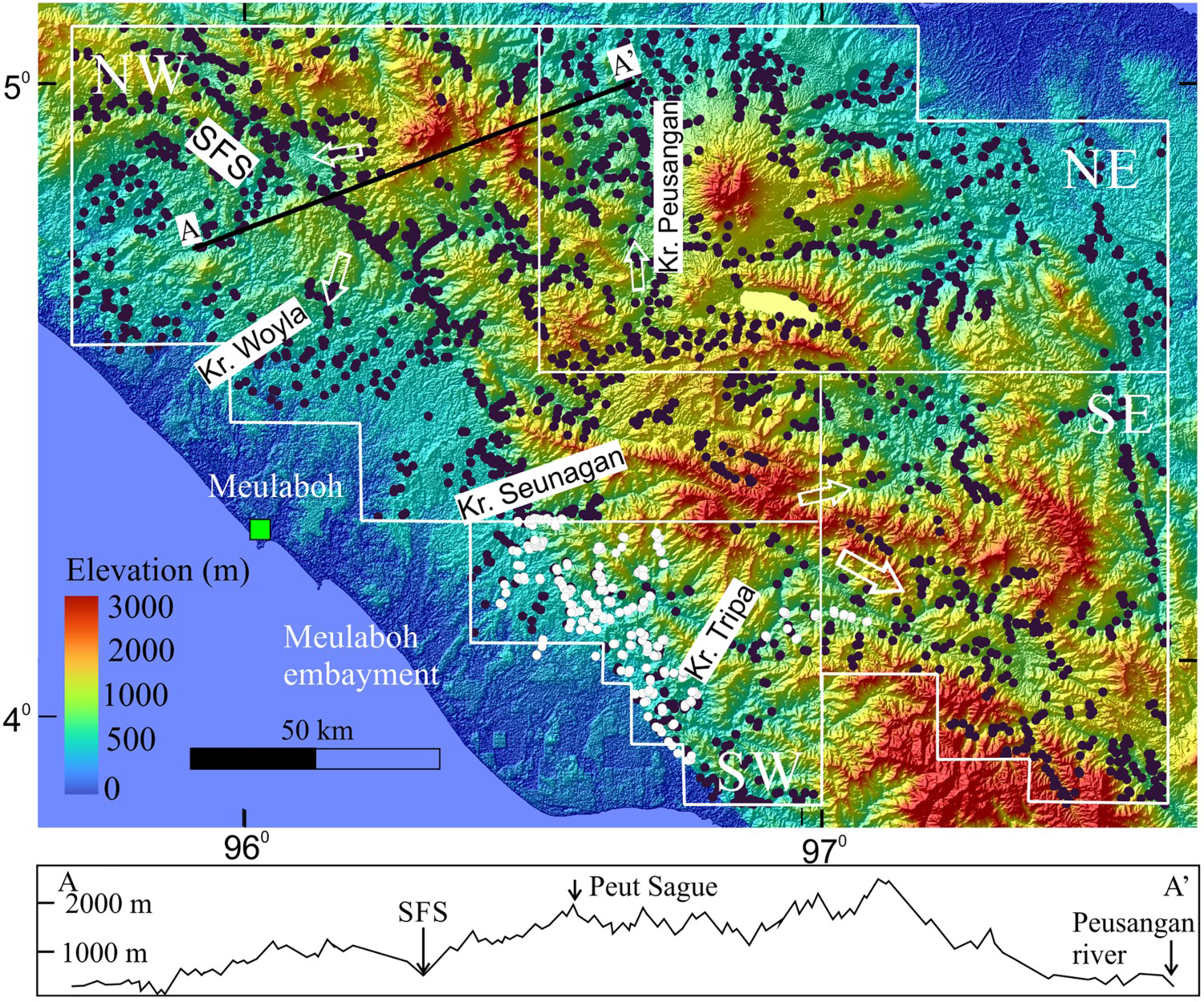
The stream sediments in central Aceh originated mostly from the western and eastern sides of the Barisan Mountains (up to ∼2500 m elevation) and locally from ridges that are variably oriented (Figure 3). This, together with the distribution of the predominant lithologic units (see Figure 2) led to the grouping of the samples into the NW Block (Woyla assemblage and intermediate-felsic plutons), the SW Block (basement complex > intermediate intrusion), the NE Block (sedimentary and intermediate igneous rocks > basement complex), and the SE Block (a mixture of all the aforementioned rocks). Within the vicinity of the western Barisan foothills, the SFS, with its flanking valleys, became the confluence site of sediments from various sources en route to their final deposition in the Meulaboh embayment (cf. Page and Young 1981).
Principal component analysis
Principal component analysis (PCA) is applied to compositional data to determine the existence of elemental assemblages that may reflect the most plausible source rock(s) and the causative geological processes, such as mineralisation (Grunsky 2010). Here, prior to PCA, the data were processed as follows: (1) All elements were expressed in parts per million (ppm); (2) the concentrations of elements below the LDL were replaced with a value that was 2/3 of the reported detection limits, although the element was excluded if more than 30% of the measured concentrations were below the LDL; (3) the outliers were normalised using the interquartile range method; and (4) the data were transformed with the centre-log-ratio (clr) transformation method to prevent closure effects (see Aitchison 1986). PCA was performed with the script Rqpca from Grunsky (2001) in R software (R Core Team 2020).
Spectrum–area (S–A) and local singularity (L–S) modelling
The S–A and L–S analyses were performed in MATLAB-based Geofrac2D software (Wang and Zuo 2015). For the first method, the spectral–area relationship (Cheng et al. 1999) is expressed as A(≥S) ∝ S−β
, where S represents the power spectrum density as a function of the wavenumber vector, A(≥S) is the area with a power spectral energy density greater than a threshold S on the spectrum plane, ∝ represents proportionality and β is an anisotropic scaling exponent that is estimated by plotting A(≥ S) against S on a log–log plot. In Geofrac2D, the procedures are as follows:
Generate a raster grid map of the geochemical sample data (this is the Fourier domain map). Enter the number of sample points to produce the A(≥S) vs. S log–log plot (this step calculates the power spectrum of the above map and forms a dataset consisting of the power spectrum density (S) and the area with power spectrum density values greater than or equal to S). Use the built-in filters (based on the least squares (LS) method) to fit linear regression lines to the plot. Generally, the larger the R2, the more reliable the fittings are; and Transform the above frequency domain maps into spatial domain maps, i.e. the background, anomaly, and noise (this step involves the inverse Fourier transformation).
A singularity in the fractal method, which is considered an index for characterising the local structural property of the distribution of metal concentration in a mineral district (Cheng 2007), is derived from the following equation as rewritten by Zuo et al. (2015): C = c*ϵα
−
E
, where C represents the average value of element concentrations, c is a constant value, α is the singularity index, ϵ is a normalised distance measure such as block cell edge and E is the Euclidean dimension. The singularity index α can be estimated from the slope of the straight line fitted to the paired data of C and ϵ in a log–log graph. For α ≈ E or α ≈ 2, the location is considered non-singular; for α < E or α < 2, the location is enriched in an element; and for α > E or α > 2, the location is depleted in an element. To obtain the optimal local singularity exponent, Cheng (2007) introduced a window-based method to estimate the singularity index with raster maps, i.e. the singularity mapping technique. However, Zuo et al. (2015) pointed out that the original algorithm for this method cannot process negative values and that the resulting singularity index is adversely influenced by the background value. These authors solved this shortcoming by inserting an additional step, step 2, into the algorithm, as shown below:
Set up a series of windows (rmin … rmax., ri … rn) to cover the study area; Identify the minimum value (tmin) within the maximum window (rmax) and subtract it from each cell; Average the concentration value C[A(ri)] for each window; Obtain the value of α − 2 from the slope of the fitted straight line of a log–log graph of C[A(ri)] versus ri; and Repeat the same procedure for all other locations on the geochemical map.
In the current study, the modified algorithm was chosen when running Geofrac2D software to obtain the singularity index and maps.
Results
Central Aceh
Descriptive statistics
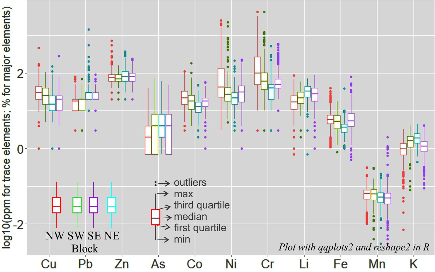
Statistical summaries of the geochemistry of the stream sediments from all four blocks are given in Appendix 1. Overall, the Cu, Co, Ni, and Cr concentrations are markedly higher in the NW and SW; Pb and Li concentrations are higher in the SE and NE; Zn and As concentrations overlap extensively among all blocks; the Mn concentration decreases from NW to NE; and the K concentration is highest in the SE (Figure 4).
Principal component analysis
As porphyry Cu and epithermal Au deposits are the dominant types in central Aceh and stream sediments with anomalous Pb surrounding the Ise-Tengkereng porphyry Cu group, the following analysis focuses on the geochemical patterns of Cu, As, and Pb. The second element is selected in lieu of Au analysis and because of its strong positive correlation with Au in the Miwah high-sulfidation epithermal Au–Ag deposit (Mulja et al. 2020), the Collins intermediate-sulfidation epithermal Au–Ag prospect (Mulja et al. 2021) in the northeast, and the Abong jasperoid-hosted Au deposit (Taylor 2012) in the southeast (Figure 1(c)).
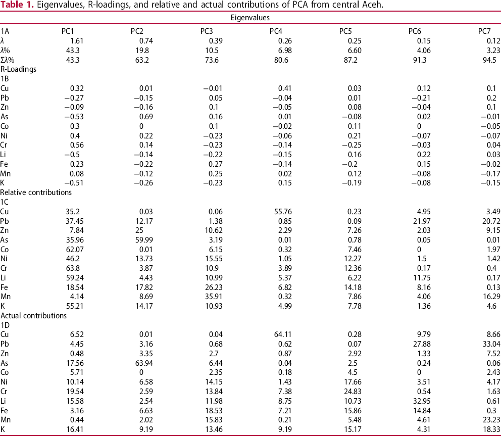
Table 1(a–d) lists the eigenvalues, R-loadings, and relative and actual contributions of the variables for PC1 to PC7 of the stream sediment geochemistry from central Aceh. Components PC1 and PC2 account for 43.2% and 19.5% of the total variation in the dataset, respectively; therefore, they represent the dominant geochemical processes leading to the elemental distributions in the samples. Copper in PC1 (35.2% variability) is moderately to strongly associated with Cr, Ni, and Co, all of which are related to the Woyla assemblage (Figure 5(a)). By contrast, Cu is the sole significant element in PC4, with the highest actual contribution of 64% among all PC (compared to a contribution of 6.52% to PC1; Table 1(d)). Hence, PC4 is strongly related to porphyry Cu deposits. Arsenic is the highest variable in PC2 (64%); it is mainly associated with rocks belonging to the NE and SE blocks (Figure 5(a, b)), where epithermal and jasperoid-hosted Au–Ag deposits occur. The biplot of PC1 vs. PC2 (Figure 5(a)) also shows that Pb is correlated with Li and K (in clays) in samples mostly originating from the SE, where former skarn and vein Pb deposits are spatially close to the Serbajadi and Doson intrusions (Figure 2). However, PC7 contains the largest variance in Pb (33.4%) among all components, despite its small variability of 3.23%. This PC, together with PC4 (6.98% variance), could represent a significant but undersampled process (see Grunsky and Kjarsgaard 2016). From the PC6–PC7 biplot (Figure 5(c)), the high Pb variability in these components is associated with rocks from the SE and, to some extent, those from the NE and NW. From the above PCA, PC4, PC2, and PC7 are therefore analyzed with fractal modelling.
Biplot of PC1 vs. PC2 (a), PC1 vs. PC4 (b) and PC6 vs. PC7 (c) for clr-transformed compositional data of stream sediments from central Aceh. Plot with FactoMinerR (Le et al. 2008). Eigenvalues, R-loadings, and relative and actual contributions of PCA from central Aceh.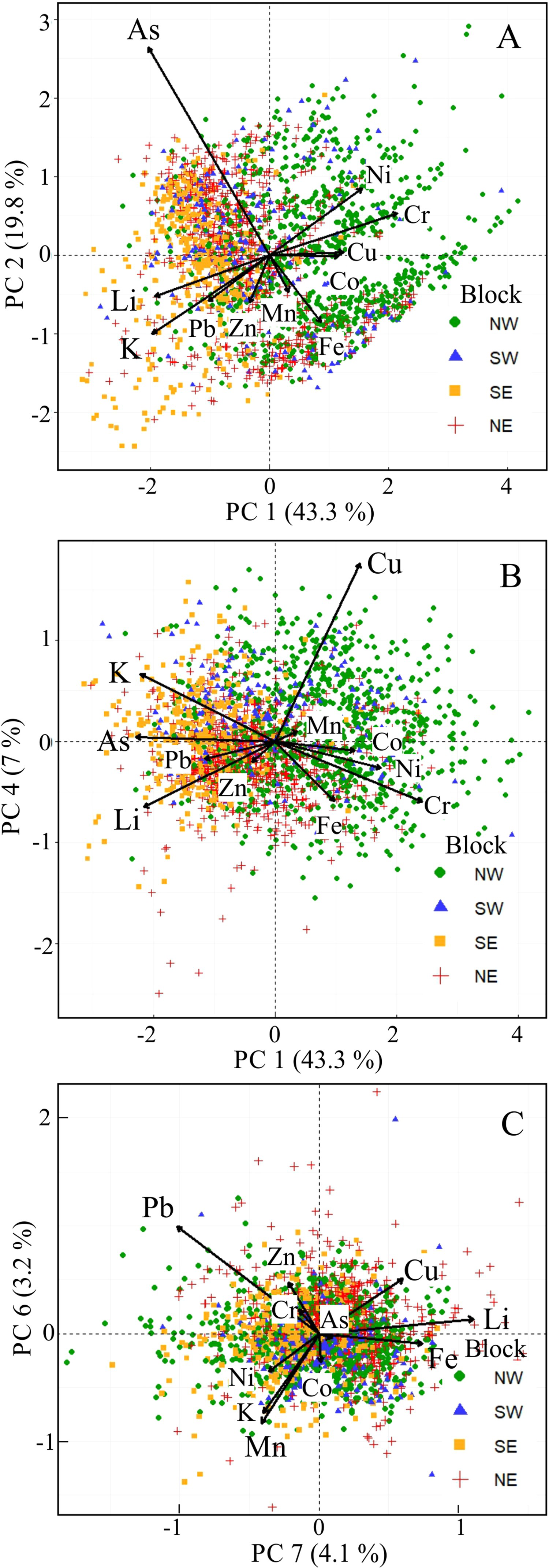
Spectrum–area and local singularity analysis
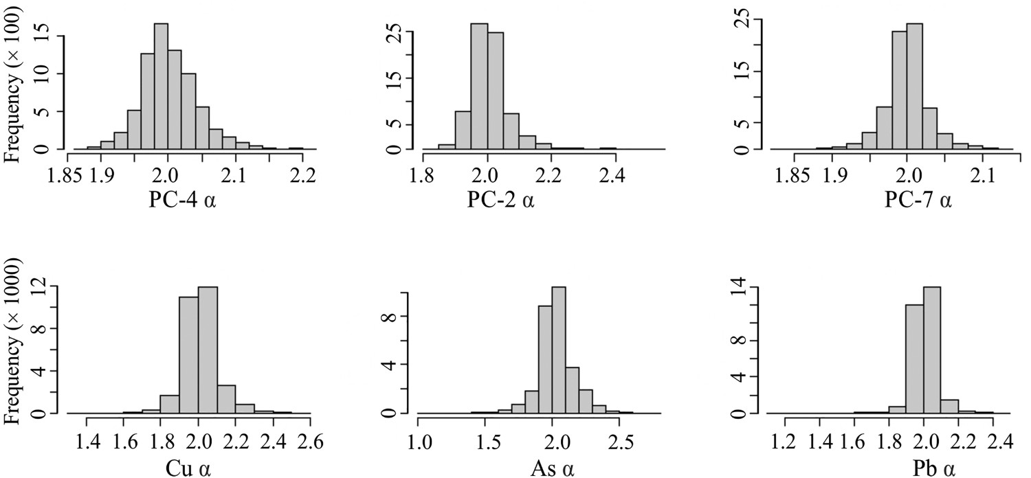
The resulting S–A plots of log [A(≥ S)] vs. log (S) on clr-transformed PC4, 2, and 7 scores and on Cu, As, and Pb concentrations show that three straight-line segments can be fitted to the data by means of the LS method (Figure 6). These lines set the dividing point on the abscissa between the background and the anomaly and between the anomaly and the noise. The α (singularity)-values for PC4, PC2, PC7, Cu, As, and Pb are summarised in frequency histograms, each of which displays a unimodal distribution (Figure 7).
Spectrum–area fractal plots of PC4, 2 and 7, and of Cu, As and Pb values of stream sediments from central Aceh with least square regression lines. Histograms of singularity index values for PC4, 2, and 7, and of Cu, As, and Pb showing a unimodal distribution for each plot. The preponderance of non-singular or background element concentrations (α ∼ 2) over the high (α < 2, enriched) or low (α > 2, depleted) values are reflected in the subsequent L–S maps. The square windows with half window sizes were set to rmin = 1, 3, 6 km, … rmax = 39 km with an increment of 3 km.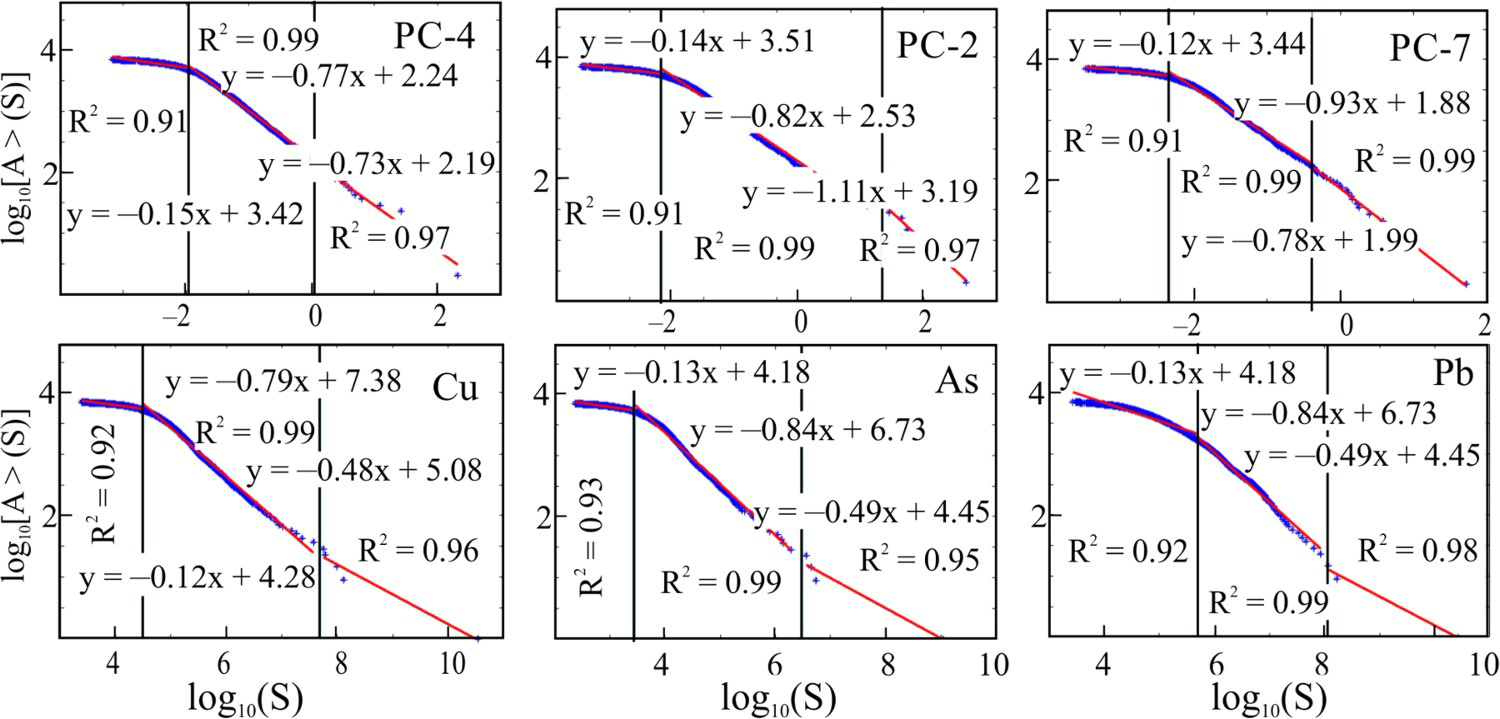
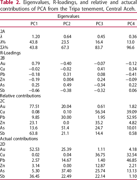
The S–A background map of PC4 scores shows a high-frequency area extending from the Tangse porphyry Cu–Mo deposit to the northern part of the Sikuleh batholith, moderate values in the south-central area dominated by Woyla and igneous complexes, and three weak anomalies around the Beutong porphyry Cu–Au–Ag–Mo deposit, the Serbajadi batholith, and the Daling pluton (Figure 8(a)). Conversely, the S–A anomalies for PC4 scores are spotty, scattered across the region, and related to most of the porphyry Cu occurrences; they are also found in areas with no known Cu mineralisation (Figure 8(b)). These anomalies are enhanced on the local singularity (L–S) map, in which the enriched (α < 2) areas are more focused, forming NW and E–W trends covering most of the Cu occurrences (Figure 8(c)).
Spectrum–area (S–A) background and anomaly maps and local singularity maps for PC4 scores (a–c) and Cu concentrations (d–f) for stream sediments from central Aceh. To prevent cluttering, site names are given only in Figure 8(a), and the major NW faults are shown in Figure 8(b). The prominent NS Samalanga–Sipopok and Lokon–Kutacane fault, respectively, traverses the Menawan and Pining area (see also Figure 2).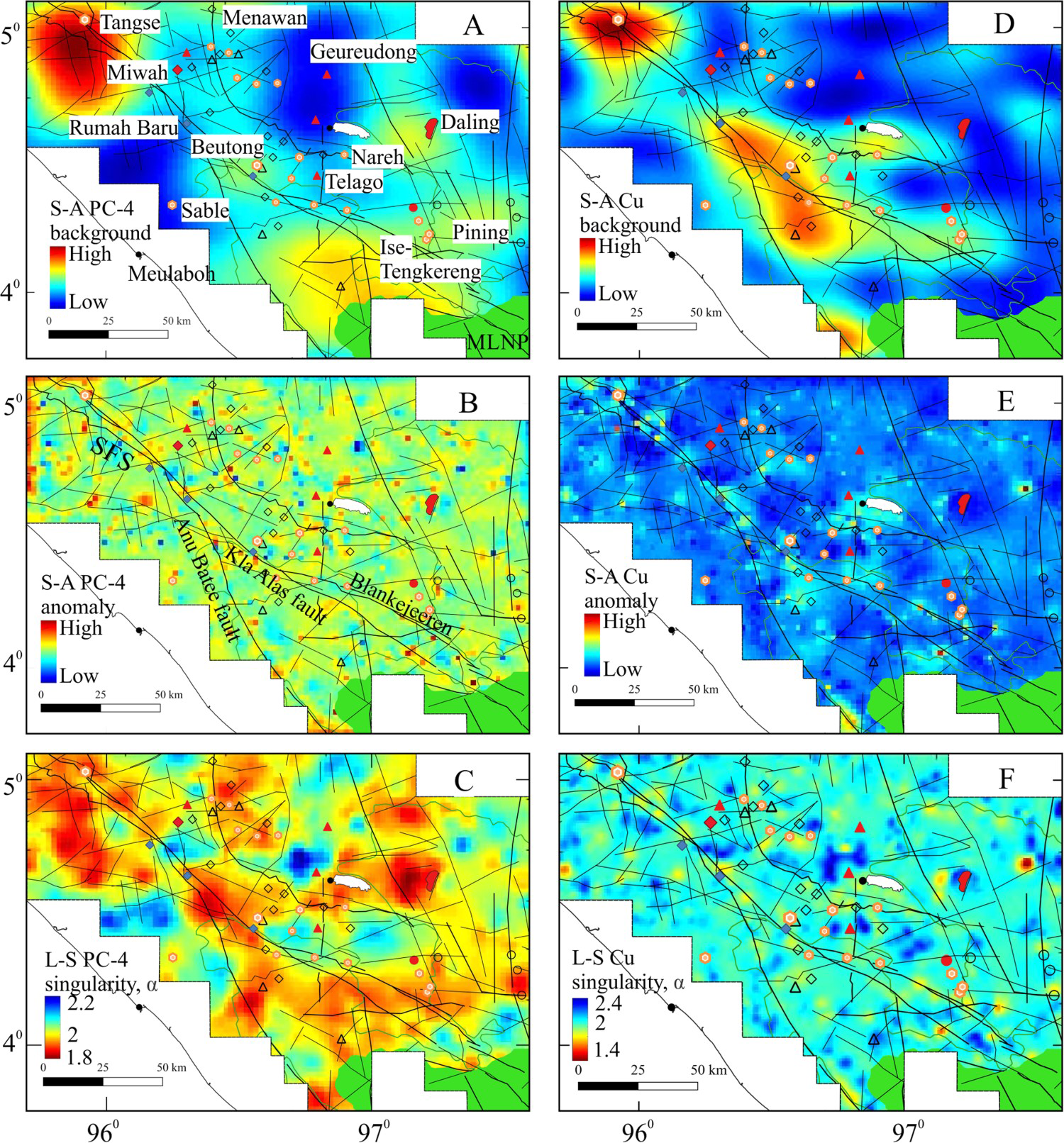
In contrast to those for PC4 scores, the high Cu values on the S–A background map form a smaller area masking Tangse (Figure 8(d)), an elongated zone along the SFS spanning from the Rumah Baru Au–Cu veins through Beutong to a cluster of diverse prospects near the bifurcation area between the Anu Batee and Kla Alas faults, and a spot farther to the south (Figure 8(d)). Additionally, two weak zones cover the areas around the Daling intrusion and the Ise-Tengkereng porphyry Cu group. Such elevated values are also displayed in the S–A anomaly map, but the anomalous areas are more restricted (Figure 8(e)). A further refinement of these anomalies with singularity modelling results in a significant reduction in the Cu-enriched (α < 2) areas and, equally importantly, in much more discrete anomalies.
Figure 9(a) shows high S–A background patterns for PC2 scores that bifurcate from Beutong to Menawan in the north and the Ise-Tengkereng porphyry group in the east (Figure 9(a)) and form a northerly ellipse oriented NE. On the S–A anomaly map, the high frequencies form clusters along the SFS, from Beutong to Daling, along the N–S-trending Pinang-Pacara epithermal Au prospects, and in an area southeast of the Ise-Tengkereng porphyry Cu group. A similar mode of distribution is shown by the enriched areas on the local singularity map of PC2 scores (Figure 9(c)). The highest As areas on the S–A anomaly map coincide with the Menawan and Ise-Tengkereng porphyry Cu occurrences, and they are similar in terms of distribution and geometry to those on the S–A anomaly map for PC2. By contrast, singularity modelling clearly defines alternating N–S enriched (α < 2) and depleted (α > 2) zones, an E–W-striking zone just south of the Ise-Tengkereng porphyry group, and individual enriched areas near the Daling pluton and other localities (Figure 9(f)).
Spectrum–area (S–A) background and anomaly maps and local singularity maps for PC2 scores (a–c) and As concentrations (d–f) for stream sediments from central Aceh.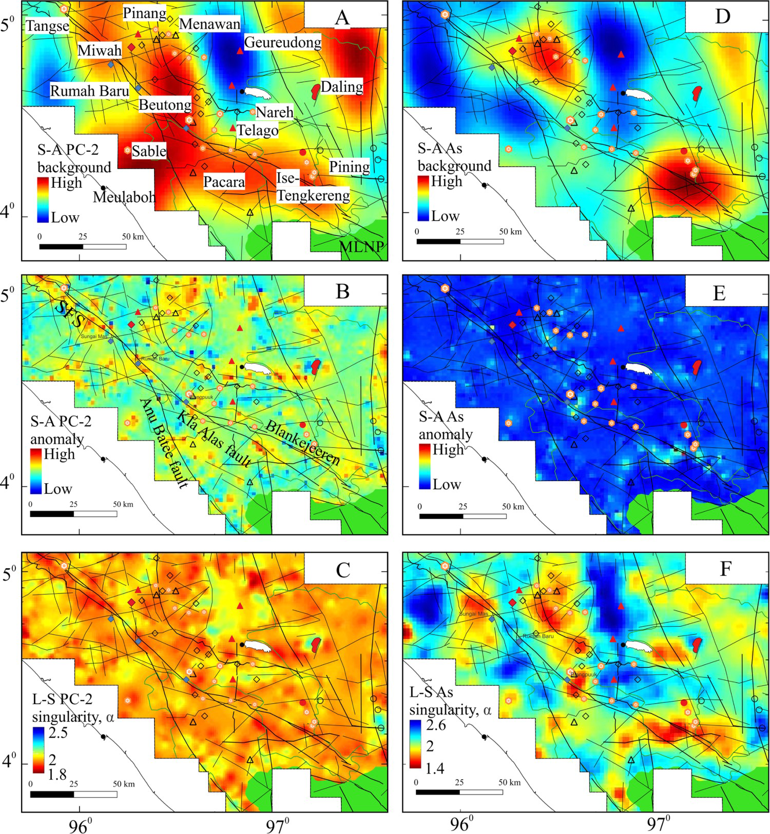
The S–A modelling of PC7 scores results in slightly elevated background values around Beutong, Ise-Tengkereng, the area north of Menawan, and the Daling intrusion (Figure 10(a)), but it produces no discriminating patterns on the anomaly map (Figure 10(b)), most likely owing to the influence of substantial Mn and K variability in this component (Table 1). Conversely, the L–S modelled Pb + Mn + K component delineates enriched α areas proximal to the Pining Pb deposit and known porphyry Cu occurrences (Figure 10(c)). The highest values on the S–A background and anomaly maps and the L–S map for Pb concentrations correspond to Pb deposits (Figure 10(d–f)). However, the latter map also displays alternating, north-trending enriched, and depleted α zones, where the enriched zones cover the majority of the porphyry Cu and epithermal Au–Ag occurrences.
Spectrum–area (S–A) background and anomaly maps and local singularity maps for PC7 scores (a–c) and Pb concentrations (d–f) for stream sediments from central Aceh.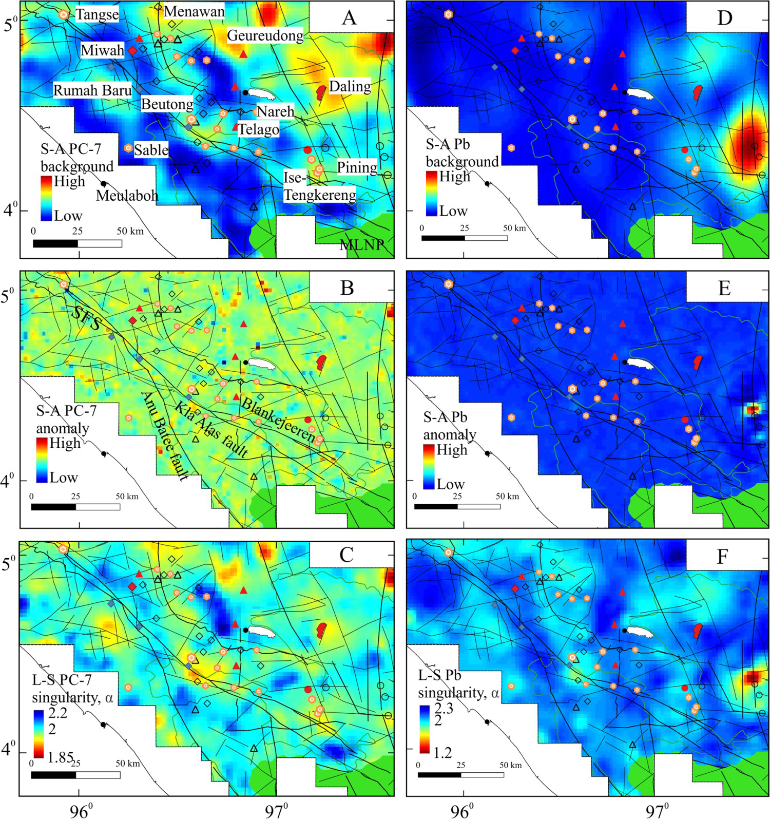
Tripa tenement
The geology of the Tripa tenement comprises the Paleozoic basement and the Woyla assemblage, into which northwest-trending magmatic rocks were emplaced during the Mesozoic and Paleogene (Figure 11). This orientation is parallel to the strikes of many faults and fractures. A statistical summary of Au, As, Sb, Cu, Pb, Zn, and elemental correlation coefficients is given in Appendix 2. Gold ranges from 0.01 to 1.08 ppm and is weakly correlated with As and Zn, whereas Cu and As are moderately correlated (r = 0.49), implying their partial derivation from Cu–As sulfosalts. By contrast, Pb, Zn, and Sb are strongly correlated (r = 0.65–0.78). On the basis of raw assays, TTN projected Cu–Mo prospects in the north and a Cu–Zn prospect in the south (Figure 11).
Geology of the Tripa tenement (after TTN 1996).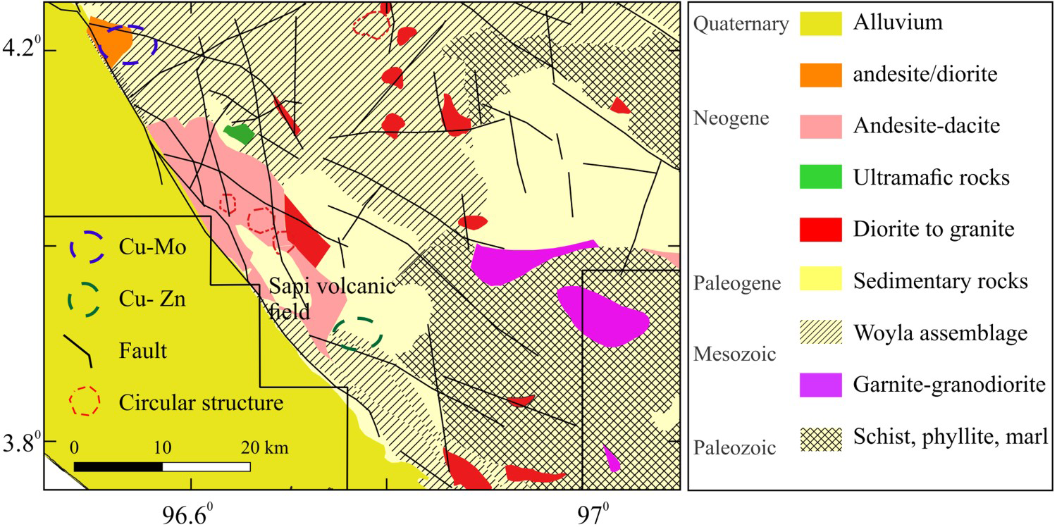
Table 2(a–d) lists the eigenvalues, R-loadings, and relative and actual contributions of the variables for PC1 to PC4 of the stream sediment geochemistry from Tripa. Components PC1 to PC3 account for 83.7% of the total variation in the dataset (Table 2(a)); hence, they reflect the controlling processes for the variability in the data. However, Cu shows the highest and second highest variability in PC3 and PC4, respectively (Table 2(c)), whereas the significant loading and contributions of Au are mainly on PC1, and the prominent variances of Pb, Zn, and As are on PC2 and either PC3 or PC4. Similar to Au, Sb provides the largest contribution to PC1, but these metals have an antithetic relationship. As a result of the above elemental variances, only the biplot of PC1 vs. PC3 (Figure 12) reveals some geological relevance. This plot shows an association of Au and As in the lower right quadrant, a Pb–Zn assemblage in the upper left quadrant, a sole Sb vector straddling the As and Pb vectors and a Cu vector near 0 in PC1. These elemental assemblages indicate that PC1 is related to Au mineralisation and PC3 to base metal mineralisation.
Biplot of PC1 vs. PC3 for clr-transformed compositional data of stream sediments from the Tripa tenement, Aceh. Plot with FactoMinerR (Le et al. 2008). Eigenvalues, R-loadings, and relative and actucal contributions of PCA from the Tripa tenement, Central Aceh.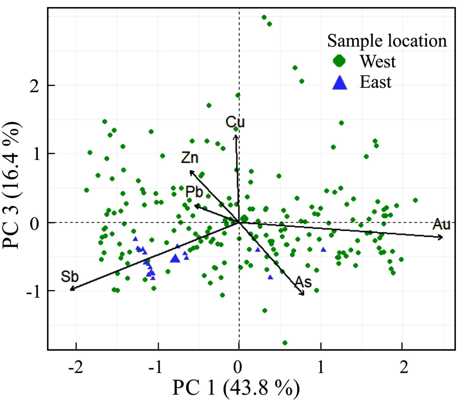
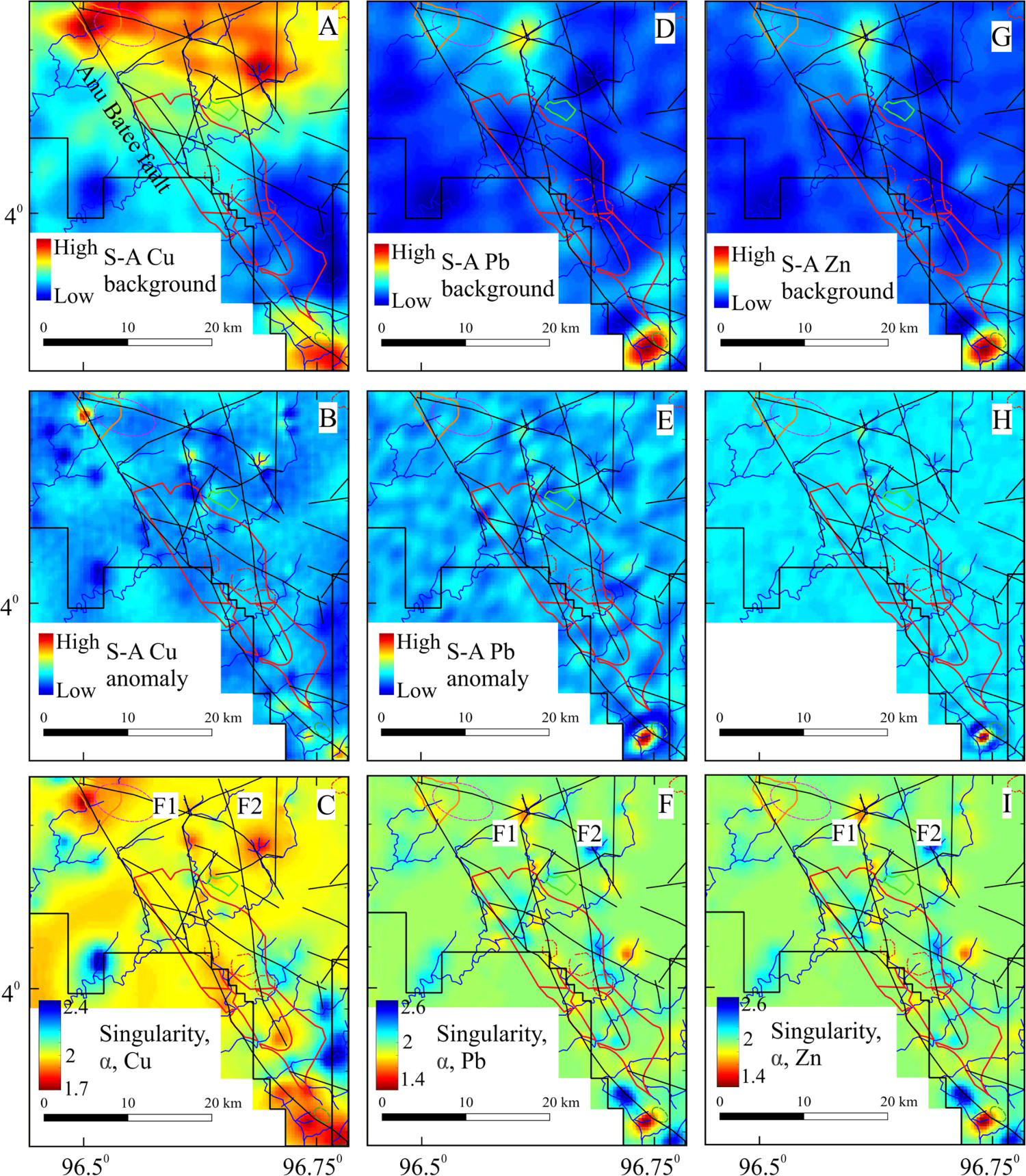
Fractal analysis was conducted on stream sediment geochemistry from the western part of the Tripa tenement because of insufficient samples in the east. While Au fractal responses are clearly displayed on both S–A and L–S maps, those of other metals are best depicted on the singularity maps (Figures 13 and 14). Collectively, they lie along the Anu Batee fault and the north-trending faults, particularly fault F1, or between F1 and F2. From the Sapi volcanic field, the metal-enriched areas (lowest α values) vary from proximal Au through intermediary Cu ± As to distal Pb + Zn + As + Sb, which coincide with the Pb–Zn and Cu–Mo targets in the south and northwest, respectively.
Spectrum–area (S–A) background and anomaly maps and local singularity maps for Au (a–c), As (d–f), and Sb (g–i) concentrations for stream sediments from the western part of the Tripa tenement. Spectrum–area (S–A) background and anomaly maps and local singularity maps for Cu (a–c), Pb (d–f), and Zn (g–i) concentrations for stream sediments from the western part of the Tripa tenement.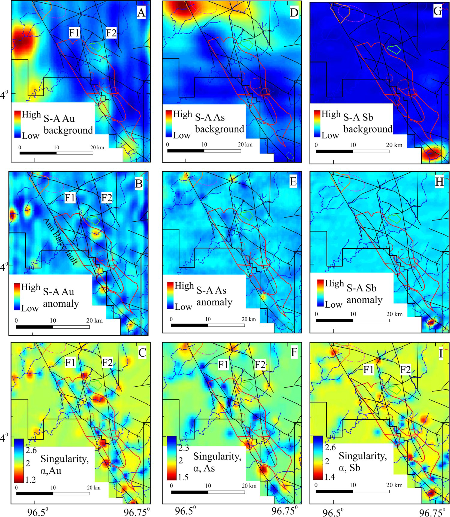
Discussion
From the above observations, the fractal modelling applied in this study produces strong to moderate Cu, As and Pb anomalies in and around the majority of the currently known porphyry Cu and epithermal Au–Ag occurrences. Additionally, the modelling defines several anomalous areas without the presence of such mineralisation (either the areas have not been explored or turned out to be nonprospective). Many of these occurrences are located in areas with 0 ranking by Page and Young (1981). This discrepancy between the two methods is attributed to the ability of S–A modelling to define anomalies and the ability of the singularity method to enhance weak anomalies, thereby supporting the conclusion of Cheng (2012) and Zuo et al. (2015). In the Tripa area, the areas with anomalous Au and Cu are still not proven to be related to any mineralisation.
Figure 15 depicts a superimposition of the singularity patterns (α < 2), structures, mineralisation and other relevant geologic features to shed light on the spatial relationships among these data inputs. The reasons for selecting singularity enriched values over S–A signals are as follows: (1) the former possess intrinsic characteristics that make them more appropriate than the latter to provide evidence layers for generating a mineral potential map (e.g. Ali et al. 2007); (2) S–A could produce artefacts (Cheng 2007); and (3) the results of singularity modelling are more suitable for predicting locations of mineral occurrences (Wang et al. 2017). Both Tangse and Beutong lie adjacent to the SFS, and the former appears to be solitary, whereas the latter could be part of an E–W porphyry Cu belt spanning from Sable in the west to Nareh in the east; perhaps the trend extends to an area enriched in As, Cu, and Pb near the Daling pluton. This multielement enrichment is observed in the Beutong and porphyry Cu deposits elsewhere (e.g. Sillitoe 2010). Moreover, as mentioned previously, E–W structures tend to be reactivated pre-Paleogene faults or fractures that are not topographically prominent but are traceable on remote sensing images, such as airborne magnetic lineaments in the Woyla block (Figure 2(b); Etheridge- Henley-Williams 1997) and in the area south of the Collins prospect, where the interpreted E–W structures link the buried intrusion related to the South Semelit porphyry Cu prospect (Mulja et al. 2003). Indeed, the E–N–E mineralisation-controlling structures, such as the Miwah–Menawan corridor, are consistent with Riedel-style mechanics in which the principal deformation zone is the SFS (Mulja et al. 2020). Thus, the string of porphyry Cu occurrences from Sable to Nareh is also plausibly controlled by E–W structural arrays.
Integrated map of L–S enriched areas on PC scores (dashed line) and metal concentrations (solid line), mineral occurrences and structures in central Aceh. Linear dashed lines are interpreted mineralisation-controlled structures.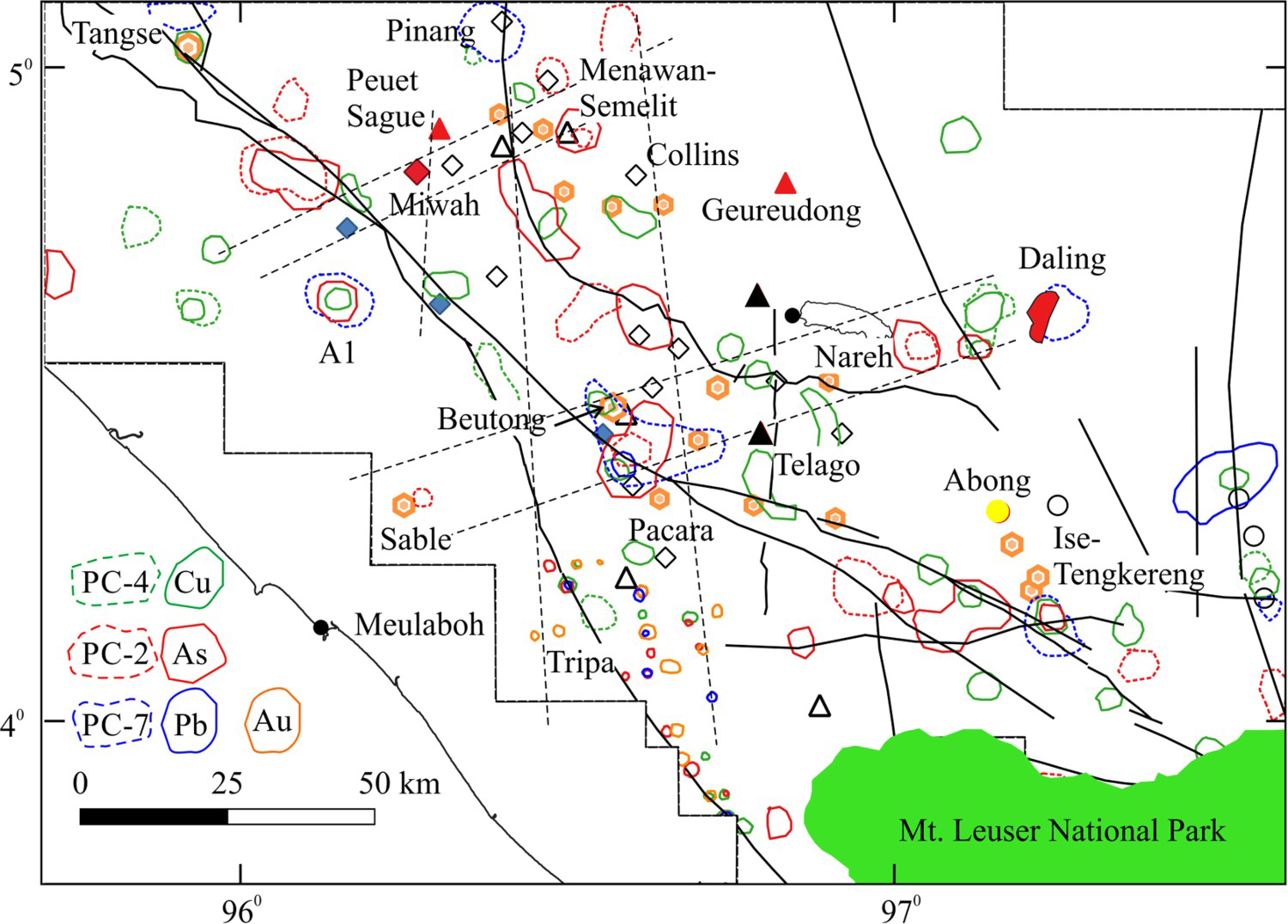
The most prominent singularity As anomalies trend N–S and coincide with most of the epithermal Au and, to some extent, porphyry Cu mineralisation from Menawan in the north to Tripa in the south (Figure 14). Additionally, the areas with fractal anomalous Au in the Tripa tenement are aligned with the above regional As trend. These spatial correlations are interpreted to relate to a series of northerly structures commonly traversing the region. Within central Aceh, they control the Au feeder zones at Miwah (Mulja et al. 2020), the Collins Au–base metal veins (Mulja et al. 2021), the Paleogene plutons in the SW, and the Geureudong–Telago volcanic centres. Interestingly, a southward extension of these N–S structures coincides with the F2 mega-fracture zone offshore Sumatra (inset map in Figure 2).
Among the fractal-generated anomalous areas, A1 on the western side of the SFS in the northwest shows overlapping Cu, As, and Pb anomalies. As mentioned above, the cooccurrence of these metals signifies a potential association with porphyry Cu mineralisation. Unless the area was previously explored and proved to be nonprospective (but not reported publicly), A1 and vicinity could constitute an exploration target. Although the area between the Nareh porphyry Cu prospect and Daling pluton host As, Cu and Pb anomalies, it is within the Leuser ecosystem area in which exploration is prohibited.
Conclusions
This study has demonstrated that the majority of the fractal geochemical patterns from stream sediments are spatially related to known porphyry Cu, epithermal Au–Ag, and skarn–vein Pb mineralisation. Moreover, the singularity metal-enriched areas, together with other empirical and conceptual data input, define the north-trending mineralisation-controlling structures for epithermal Au–Ag and porphyry Cu mineralisation and add another E–W structural-geochemical-magmatic corridor for porphyry Cu mineralisation. Hence, legacy data from the British-Indonesian NSP remain useful for separating anomalies from background values with the above techniques. This conclusion implies that similar data for the other parts of Sumatra investigated by the same geological team could be reevaluated with fractal methods for mineral assessment purposes.
Footnotes
Acknowledgements
The author is grateful to Arie Hede for generously supplying the data from the NSP, and to Mohamad N. Heriawan for facilitating such data usage; both are faculty members at the Bandung Institute of Technology. Zuo Renguang of the China University of Geosciences, Wuhan and Wang Jian of Chengdu University of Technology, Chengdu, kindly provided their MATLAB-based program GeoFrac2D for running the fractal analysis. The late Greg Parham provided reports on the Woyla and Tripa tenements. Corrections and constructive comments from Mohammad Parsa, an anonymous reviewer and the editor improve the early version of the manuscript.
Dedication
This paper is dedicated to the memory of A.K. Djauhari, former head of the Aceh Mines Department, who aspired to see a sustainable resource industry in Aceh for the benefit of the people at large. His hospitality, wit and assistance made my venture into his homeland a lifelong enriching experience. Though he was an indigenous Acehnese, his impeccable spoken ‘high-level’ Sundanese, a distinct language of West Java, was truly remarkable and admirable.
Disclosure statement
No potential conflict of interest was reported by the author(s).