
Abstract
This article examines the intersections between the visual, spatial and material and considers how these interactions capture the border politics of everyday ‘banal’ objects. We do this by looking at some of the objects and things that constitute the ‘Balkan Route’ through Europe: posters, signs, directions, notices, flyers and maps produced by state authorities and volunteer-led aid networks. We use objects to reflect more broadly on how seemingly banal and everyday things become incorporated into the political work of states and become constitutive of fluid borders. We argue that everyday objects become visualisations of states and authorities, and help to make and regulate physical spaces. We show how each visual object encountered along the route gives us a broader insight into the macropolitics of European border regimes, specifically the effects of ‘closed borders’ and the criminalisation of aid networks. The article pushes forward the ‘aesthetic turn’ debate in international relations by bringing in insights from political geography and materialism, and suggests that a walking methodology can be a productive way of encountering the visual and understanding how its physical location creates political effects.
Introduction
This article examines the intersections of visual, spatial and material in international politics, analysing encounters with ‘everyday’ objects (Guillaume and Huysmans, 2018) produced and displayed along the so-called ‘Balkan Route’ of migration through Europe: official and government signs, notices, posters, maps, flyers, and directions, as well as their less formal counterparts made by solidarity groups and volunteers. We examine these objects as the ‘things’ and ‘stuff’ of international politics (Salter, 2016), analysing how their visual effects govern space and are implicated in acts of bordering and its resistance. We define the objects of the refugee ‘crisis’ – maps, flyers, posters, directions, signs – in terms of the ‘micropolitics’ of international relations (IR), the ‘features of social life that slip through our normal schematic or binary frameworks’ (Solomon and Steele, 2017: 270) and are treated as ‘little nothings’ (Bayart et al., 2008; Macherey, 2009), but when considered in relation to European Union (EU) border governance, can shed light on macropolitics and macrostructures.
We investigate how things that are ‘seen but unnoticed’ (Featherstone, 1992: 159) become a part of the border infrastructure and means of governing spaces and mobilities. Displaced people on the move encounter frequently objects with communicative and political effects, many of which are directed specifically at them: fences, flyers, maps, posters, signs, directions and graffiti. The objects are frequently inscribed with instructions: how to register with asylum services, how to reach refugee camps, where to go and not to go (Figure 2). None of these appear arbitrarily; rather, seemingly banal objects, such as maps and flyers showing directions to camps, are deployed strategically and with regulatory effects, intending to manage displaced people away from specific sites (commercial or public spaces) and towards others (camps and reception centres). This is the micro-level with which this article engages. At the macro-level, we locate EU border politics within which countries like Serbia and Greece are embedded, acting as ‘partners’ securing the EU’s externalised borders (Stojic Mitrović and Vilenica, 2019).
The visual artefacts we examine are the ‘things’ and ‘stuff’ of migratory routes whose seemingly apolitical and ordinary appearance stands in contrast to the increasing violence that has shaped refugees’ journeys through Europe (Davies et al., 2019). However, as we show, the ‘things’ and ‘stuff’ are not separate from the violence used to enforce borders (Jones, 2017); rather, they are a part of the infrastructures and practices that embody EU and state border management. As such, they are significant as visual representations of states and indirect forms of bordering, intimidation and harassment, affecting the ‘physical experience of moving in and through particular places’ (Mannergren Selimovic, 2018: 5).
The main research questions we engage with in this article are as follows: how do these objects contribute to increasingly diffused processes of bordering (Darling, 2016) and governance perpetuated by state authorities? When do ‘everyday’ objects, such as directions on reaching a refugee camp, become a part of the governance infrastructure, and when do they become political? Can the inclusion of these visual, spatial and material objects within our analysis ‘correct skewed analytics of power that focus on elites or structural power’ (Guillaume and Huysmans, 2018: 2)? Following Solomon and Steele (2017: 270), we suggest that the everyday objects of European border management (and its resistance), ‘offer compelling reconfigurations of IR, where the varied sites of global politics are located and the role of “ordinary” people within it’. Whereas Solomon and Steele (2017) examine the micropolitics of IR through affects, spaces and time, we move the discussion on towards understanding the ‘features’ of micropolitics as multidimensional in different ways – as visual and material, embedded and located within spaces.
Empirically, we focus on the Balkan Route(s) through and towards (and back from) Europe; our observations are drawn from fieldwork in Serbia and Greece, with emphasis on Belgrade and Athens. Displaced people moving through this region tend to come to the EU from Afghanistan, Syria and Iraq, amongst other countries (United Nations High Commissioner for Refugees (UNHCR), 2019), and typically many would have been on the move for months or years, coming into the EU via Turkey. Whilst the global focus on the so-called ‘refugee crisis’ peaked in 2015, and the EU announced the ‘closure’ of the ‘Balkan Route’, people nonetheless continue to arrive, with around 21,000 arrivals in 2019 via Greece alone. The mobility of displaced people across the region continues to be heavily regulated in this space, which forms a part of EU’s ‘external’ border (Stojic Mitrović and Vilenica, 2019). Our focus in this article is on how those groups of displaced people are communicated to – rather than how they interpret the communications directed at them. The refugee community along the ‘Balkan Route’ is diverse culturally and linguistically, so capturing how they understand signs and maps directed at them would be challenging methodologically. Rather, we focus on how visual communication directed at refugees creates specific imaginings of local worlds, infrastructures and border regimes, and attempts to restrict mobility of migrant groups within states.
This article contributes to current debates in IR that recognise the importance of ‘the everyday’ – ‘continuing interest in the power of subjects, practices, relations, sites and things that are usually kept out of the political and analytical vision that is pervasive in IR’ (Guillaume and Huysmans, 2018: 2). Unlike other studies of the material and everyday objects associated with migration, which examine how local residents and activists engage with objects left behind by migrants in order to make statements about migration policies (Soto, 2018; Squire, 2017; Sundberg, 2008), the objects and signs we discuss here are produced by states, local authorities and activist groups and we use them as a starting point to reflect more broadly on the border policies within which they are embedded. As Mannergren Selimovic observes, ‘these explorations of the generative, agential work in the everyday are helpful in order to address the crucial question for IR concerning how the micro is connected to the macro’ (Mannergren Selimovic, 2018: 4), a question that runs through our discussions in this article.
Whilst there is now a rich body of literature examining the visual in IR (Bleiker, 2001; Friis, 2017; Hansen, 2015; Heck and Schlag, 2013; Moore and Shepherd, 2010), there is less consideration of the spatial or material dimension of visuals and visual objects, or how spaces and material objects themselves can be visual or produce visual effects. In IR, there is also less of an emphasis on the visuality of the banal (e.g. signs, maps, directions and notices). We broaden the discussion of what and where the visual is and how by engaging with both the politics of the everyday and the aesthetic lens we can establish a deeper understanding of ‘new sites […] of international politics’ and how they are generated, particularly through ‘the everyday’ (Callahan, 2015: 895). We explore how surveillance and border governance is occurring at a distance (Guillaume and Huysmans, 2018) and banal objects contribute to this work. Thus, the significance of this article lies in its discussion of how the spatial and visual interact, and do the political work of governments, authorities and activist movements.
We engage in questions about borders, space and visuality by employing a walking methodology (e.g. Lee and Ingold, 2006; Pink, 2008a, 2008b), which involves walks around research sites as a way of understanding how spaces are constituted. Aradau and Huysmans (2014: 598) suggest that ‘method and methodological reflection can be a key site of revisiting critique and politics in IR research’, and hence we suggest that walking allows a different engagement with the visual (and the political). We follow Parker et al.’s (2009: 583) call for a more fluid understanding of how bordering practices work, and a recognition that they are no longer fixed or located solely at traditional border posts, but rather are increasingly ‘located in zones that defy a straightforwardly territorial logic, whilst also being performative’ (Salter, 2012). Walking and seeing maps, signs and instructions allows us to see how the macropolitics of borders are ‘performed’ (c.f. Salter, 2016) through everyday visual objects.
This article is structured as follows: the next section outlines our theoretical framework in which we combine aesthetic IR approaches with insights from political geography and literature on the political effects of material things. It also provides the definitions of ‘the political’ and ‘activist’ as used in the article. We then discuss our methodology and provide a short background to the refugee routes through Athens and Belgrade. An empirical section follows, first with a discussion of official signs and notices and how they attempt to regulate refugees’ behaviour in particular spaces: how they politicise banal objects into tools of macropolitical governance. We then discuss the ‘unofficial’ signs and notices made by activists, noting how the two sets of signs work together to create a visual landscape of rules and regulations, and that fluidity and relationships exist between the ‘official’ and the ‘unofficial’.
Visual politics and regulation of space
In our consideration of the intersections between the visual, spatial and material, we draw on three key literatures: one which suggests that our understanding of politics is often shaped by our consumption and production of images or other aesthetic forms (Bleiker, 2001; Bleiker et al., 2013; Callahan, 2015; Hansen, 2015; Moore and Shepherd, 2010; Rancière, 2010); a second, which recognises that, the world is made up of things, stuff, objects’ (Salter, 2016: vii), ‘little nothings’ (Bayart et al., 2008; Macherey, 2009), and that these help us to think about the power relations that exist in the world around us; and a third, which discusses the circulation and regulation of people through spaces (Bulley, 2016).
By way of setting out some definitions we use in the article, we understand objects produced by local/national/EU-level authorities as being ‘political’ when they are used to reinforce the idea of a state and its borders as ‘natural’ (Jones, 2017: 5). The border politics of everyday objects produced by states and their authorities capture and communicate the idea that mobility restrictions are ‘natural’ and that people’s movements across borders and within states themselves should be governed and regulated. In defining the state here we borrow from King (2016), who sees it as a relationship between people based on domination and hierarchy; as such, an object is politicised when it either enforces or challenges this hierarchy. Subsequently, we also consider objects and posters produced by activist and volunteer communities, such as those in Figure 1, to be political when they take on or challenge the role of the state and the idea of its borders as ‘natural’. We understand activism to be an inclusive term, as set out by King, as acts or individuals that ‘either intentionally or otherwise potentially transforms or escapes the state’ (King, 2016: 17), be that solidarity movements, volunteers or non-governmental organisations (NGOs), as well as those who, under a more exclusionary definition, define themselves as activists. 1
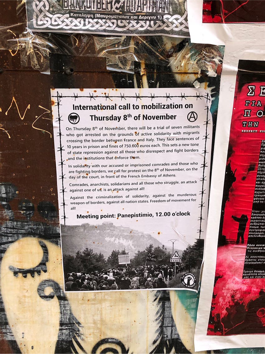
‘International call to mobilisation’ poster, Exarchia, Athens (December 2018). All photographs by the authors unless otherwise stated.
It was activist-produced graffiti that initially drew our attention to the micropolitics of borders and their resistance. What came to be known as the refugee ‘crisis’ is often represented visually, not just in the media and government signage, but also through activist groups’ graffiti and messages, such as ‘Refugees Welcome’. We see solidarity artefacts and graffiti as an instance of Mitchell’s (2002: 178) ‘vernacular visuality’ or ‘everyday seeing’, the ‘unmediated or immediate visual images and experiences’, and as what could be understood as ‘fleeting moments (that) can paradoxically be simultaneously fleeting and durable’, understood by Guillaume and Huysmans as being ‘ephemeral’ (2018: 10). Following Rose (2012: xviii), we are interested in activist-produced signage for its potential to reflect ‘cultural significance, social practices and power relations’ and disruptions of the ‘mainstream ways of seeing, understanding and acting’ (Callahan, 2015: 898). Relatedly, we are interested in government and local-authority-produced ‘stuff’ as a jumping-off point for understanding the power relationships and regulations that are used to govern refugee mobility locally, as well as across borders.
In developing our approach, we followed Rose (2012: 11), who argues that social scientists should answer questions by producing images, and ‘experimenting with making images in order to explore the nonrepresentational aspects of the social’. Our interest in taking photographs and presenting them in this article is contextualised by these debates and also by wanting to show how spaces along the Balkan Route(s) are being shaped by visual artefacts produced by authorities and activists. We present photographs mainly as supplementary documents that help us to describe the visualisation of politics we are referring to, whilst also accepting that the taking of these photographs within itself represents a privileged gaze that must be engaged with. They are not presented as art work, nor as the telling of another person’s story, but rather as a representation of the visual landscape in which these artefacts were observed, with a recognition that our role is to ‘avoid putting ourselves so firmly in the centre of the research that we erase, obscure and displace the migrants themselves’ (Lisle and Johnson, 2018: 3). In taking this position we do not presume to know how each artefact is responded to by different groups, but rather we discuss the politicisation of these signs based on their particular location, content, visuality and materiality.
Recognition of the role of privileged and oppositional gaze is an important factor when engaging with aesthetic responses to the political. Discussions of oppositional gaze have traditionally been associated with film studies and the representation of women, the black body and black women in films (Diawara, 1990; Doane, 1988; hooks, 2003), yet they also have application when thinking about the images we observed along the Balkan Route(s) and the role of our gaze as witnesses. Spectatorship places us ‘in positions of agency; and race, class and sexual relations influence the ways in which this subjecthood is filled by the spectator’ (Diawara, 1990: 33). As such, we embark on this project with a critical recognition of our own positionality as researchers. Our investigations of visuals and space occur in the knowledge that this process involves both our own interpretation and a process of unintentional selectivity in the framing and taking photographs, as well as selecting relevant objects to photograph. In recognising this we have looked to partially overcome it by thinking about how we can incorporate the detail from the settings (visual, spatial and material) and how we can ‘pay attention’ to what objects can tell us about the ‘everyday life-worlds’ (Lisle and Johnson, 2018: 10).
We also draw on ideas from political geography in order to craft a framework that will help us to understand the spatial implications of visual objects. This literature suggests that physical spaces become places through place-making activities – collective action, memory, shared values and other practices – as people ‘layer their own understanding of abstract spaces to create subjective spaces’ (Jones and Evans, 2012: 2319; Pink, 2008a, 2008b). Jones and Evans (2012: 2321) note that urban buildings are ‘not inert actors, but are woven into spatio-temporal webs of associations’. They define the routes people take and the spaces people use. We consider the role of objects, buildings and spaces in directing and diverting refugees.
Places are defined by sets of social relations, ‘brought together at a particular location’ (Jones and Evans, 2012: 2320; Massey, 1994). As Nicholls et al. (2013:4-5) suggest, specific sites such as parks, public squares or districts can become focal points for communities and protest movements, by helping to foster interactions and build networks. For activists, physical spaces are important because they can become places of solidarity and resistance (Leitner et al., 2008), becoming ‘autonomous geographies’ where laws and social norms can be questioned and collective politics practised (Pickerill and Chatterton, 2006: 1). Spaces also, it must be recognised, are further politicised by the act of becoming an important location of solidarity. As one interview with a NGO in Belgrade reminded us, parks may be centres for solidarity one day and restricted by authorities the next.
Methods
This article draws on a broader set of field research trips that began in 2015 and form a part of a larger ongoing project. In this section, we provide a short overview of the fieldwork and its core methods as a way of contextualising the research. Here, fieldwork interviews inform our findings but are not the focus – our focal points are the visual and spatial aspects of border management, researched through a walking methodology.
The broader context of our ongoing research involves eight fieldwork trips to Belgrade between 2015 and 2018, with one trip to Thessaloniki in 2017 and six trips to Athens between 2017 and 2019. Altogether this amounts to around 10 weeks in the region. During these trips, we engaged in four core research methods: participant observation with solidarity groups in Belgrade and Athens; interviews with aid organisations, activists, volunteers and refugees in both cities as well as supplementary interviews with camp officials, local and government officials, and EU officials. We also carried out observations of key sites gathered from walks around spaces central to aid efforts and refugee support (including public parks, squats, informal housing, formal and informal aid provision sites, day centres for refugees and entire neighbourhoods, such as the Exarchia neighbourhood in Athens where around a dozen refugee squats are located) and reception centres in Belgrade. Our material consists of several thousand photographs, around 60 interviews and conversations and interviews with camp officials, volunteers and activists. We draw on this body of data in this article as contextual knowledge, but do not cite interviews extensively as our focus is on the visual and material.
Similarly, we do not engage with questions of how refugees themselves engage with these signs. There does not exist one singular refugee experience and to try to suggest there is would be both misleading and unethical. Rather, what we do in this article is to show how different aspects of the border regime (as well as support, provision, camps, etc.) are communicated. What attempts do local authorities make at representing these things visually? From this we are able to deduce the spatial effects by noting what is being communicated (e.g. a camp) and what is not (e.g. other amenities) without assuming a particular situated response of a large heterogeneous group of people.
Walking around the city and the key spaces discussed here became a methodology in and of itself (Lee and Ingold, 2006; e.g. Jones and Evans, 2012; O’Neill and Hubbard, 2010). Walking around is ‘a way of thinking and of feeling, through which, in the practice of pedestrian movement, these cultural forms are continually generated’ (Ingold and Lee Vergunst, 2008: 2). Because walking was so integral to the place and its activities, we followed Pink’s (2008a: 192) vision of the ‘urban tour’, that is, ‘an embodied and reflexive engagement with the discourses, materiality, sociality and sensoriality of a particular way of being in a town’. Pink (2008a: 192) does not outline a ‘how-to’ but rather suggests a broader reflection on how ‘ethnographic places are made and imagined and how we might interpret them theoretically and reflexively’. Walking is probably the most comprehensive means by which to get to see and know particular spaces, since it encourages ‘a focus on detail, with normally mundane, ignored and relict features of the streetscape having considerable capacity to affect’ (O’Neill and Hubbard, 2010: 52).
Walking around the cities allowed us to see signs and objects and note their locations. In this way, we were able to engage with what Solomon and Steele (2017: 270) call the features of the micropolitical that ‘overflow’ from the ‘larger categories’ of international politics, such as ‘nation, state, economy [and] security’. Walking around cities was partly a practical concern – for instance, we had to walk between different aid-providing sites or spaces used by displaced people – and as such, we came to note the relationships between visuals, objects and space. We walked around the cities ourselves, and at times with activists (our camp visits were heavily regulated by camp officials’ presence), who alerted us to spaces that were significant in local aid efforts or to refugees. We focus on the ‘mundane’ (O’Neill and Hubbard, 2010), which helped us to better understand the larger visual and spatial landscapes to which these objects contribute. Walking around the key sites with activists and local colleagues also facilitated what geographers call the ‘go along’, ‘a hybrid of interviewing and participant observation’ (Jones et al., 2008: 3), and this is how we came to learn about the significance of specific practices and places, as well as observe patterns between the multiple field sites.
Engaging with physical environments through walking reveals how the dynamics of international politics – border closures, migration policies, security policies, global capital – are manifest visually in their physical environments, and how spaces can be transformed into places through place-making activities (Jones and Evans, 2012). It is a useful way of seeing how the official and unofficial notices, posters, flyers and messages interact and form part of a broader visual landscape, rather than existing as discrete forms.
Balkan Route(s) through Europe
In this section, we outline the political context in which we encountered the everyday visuals produced by the European border regimes and activist groups. What is commonly known as the ‘Balkan Route’ is, in fact, both a set of physical routes and an imagined space and place constructed as such by the EU’s Border and Coastguard Agency Frontex (El-Shaarawi and Razsa, 2019). Therefore, we see the naming of the route and its physical spaces as inherently political place-making (c.f. Jones and Evans, 2012; Massey, 1994) of imagined spatial peripheries. We thus see the name the ‘Balkan Route’ as problematic. We place the route name in quotation marks and use the alternative Balkan Route(s) (Obradovic-Wochnik, 2018) to signify the complexity of the multiple and divergent routes that are constantly ‘opening’ and ‘closing’ or being disrupted.
Generally, displaced people often make their way to the Balkans via Turkey, either overland then through Northern Greece and Northern Macedonia, by boats to one of the Greek islands or they might arrive via the other intersecting routes (see El-Shaarawi and Razsa, 2019). The plan for most is to make their way either to Serbia and Bosnia with a view to crossing EU borders through Croatia or Hungary. However, the reality of the route is that people are constantly stopped, ‘pushed back’ from borders violently, are detained or die on the way. In this article, we examine some of the infrastructure (and its visual representations) aimed at preventing or slowing down progress through ‘the route’.
The ‘Balkan Route’ experienced a high number of new arrivals in 2015; Serbian officials at the Commissariat for Refugees estimate that close to a million people travelled through Serbia between the summer of 2015 and spring 2016 (author interview, Belgrade, 2018). In both Greece and Serbia, grassroots organisations, local populations, NGOs, solidarity groups, volunteers and activists responded to the on-the-ground needs of refugees, organising everything from sea rescue (Afouxenidis et al., 2017) to accommodation and informal aid distribution. Following Sundberg (2008: 874), we see the movement of people across Europe as creating ‘geographically specific landscapes of border crossings’, which in turn produce the kinds of signage and objects we discuss.
The EU–Turkey deal has meant that a larger proportion of refugees arriving into the Greek islands remain there for over 18 months (author interview, Samos, 2019) and fewer are making it through the route. Despite this, arrivals in 2018 show an upward trend (author interview, 2018), but, unable to move forwards, most people are now stuck in Serbia, Bosnia or Greece with many, but not all, living in reception centres or various types of refugee camps, almost all of which are financed by the EU. Hence, we follow Stojic Mitrović and Vilenica (2019) in seeing the ‘Balkan Route’ as a ‘borderscape’ to which EU security is externalised; this is the ‘macro’ level at which our article engages with border politics. Whilst transit countries set their own migration policy, Serbia and Greece’s involvement in the broader dynamics of the ‘Balkan Route’ is largely directed towards supporting EU border policies.
Borders and macropolitics of the everyday
Across the region, large numbers of displaced people also live in various types of informal housing. An informal network of squats is especially active in Athens, with Belgrade squats having been largely demolished by local authorities and driven underground. Many of the Athenian squats are operated by local anti-authoritarian, leftist and anarchist groups with a long tradition of squatting (see e.g. Apoifis, 2017); they are also mainly located in the Exarchia neighbourhood, which is set up to support this kind of activity, with activist-run healthcare centres and schemes in place to facilitate donations of food, enabling the provision of cooked meals within the squat environment. In Belgrade, much of the refugee support activity has been concentrated around a similarly politically active neighbourhood, Savamala, which was the focal point of local arts and social movements.
Against this background, public spaces such as parks and transport hubs, as well as abandoned or derelict buildings, became important places for refugees transiting, or waiting in the South East Europe (Afouxenidis et al., 2017: 30; Obradovic-Wochnik, 2018), as sites not only of aid, but also of surveillance. Public places, however, only give an impression of being inclusive and ‘free’, but in practice are exclusionary (Bulley, 2016). Similarly, Jones (2017: 11) argues that ‘private property and enclosures on land and the sea’ are ‘widespread parts of how states maintain privileges by restricting movement’. As Obradovic-Wochnik (2018) argues, transit cities like Belgrade displace refugees from urban areas whilst simultaneously pushing them towards their ‘designated’ accommodation in reception centres and refugee camps. In this context, everyday objects, posters, instructions, maps and flyers directed at refugees become an important part of place-making and visualising borders, or their subversion.
In the following section, we take a closer look at the banal and everyday objects that ‘do’ the political work for migration authorities and activist groups, the ‘seen but unnoticed’ (Featherstone, 1992: 159). It is through engagement with these objects, we argue, that we can develop a deeper understanding of ‘everyday life-worlds’ (Lisle and Johnson, 2018: 10). In what follows we consider both official and unofficial signs, with the understanding that the relationship between the two is neither clear nor binary and that engagement with both helps us to think more deeply about the micropolitical in the context of border management and migration governance.
‘Directions to the camp’: Communicative effects of local authority signs and maps
Official communications directed at refugees, in forms of signs, posters and flyers, act as a form of visual regulation with the aim of governing spaces without need for the constant physical presence of authorities (c.f. Barry et al., 1996). Here we examine how states and borders are made visible to refugee and activist communities, recognising that border struggles occur not just where physical lines exist on a map, but rather where borders exist ‘in all their manifestations’ (King, 2016: 15). We follow Barder’s assertion (2016: 32) that when seemingly banal objects are examined in relation to a broader issue or politics (in our case, migration and the securing of borders), the objects have the potential to reveal hierarchies and hidden power and its trajectories. Barder (2016: 32), writing about barbed wire and its role in producing ‘spaces of enclosure and control’ and its intersections with ‘the state of exception’, also points out that such objects often become normalised as passive, disappearing as they do into broader urban landscapes.
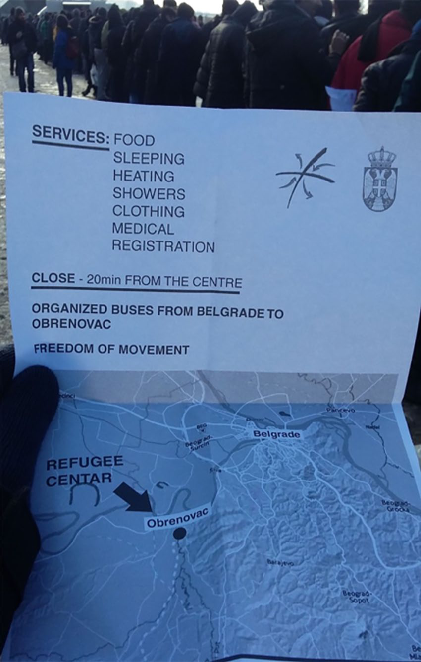
The normalised and banal things (c.f. Barder, 2016) populating the visual landscape encountered by refugees, and produced by local, national and EU authorities, rely on functionalist, plain and seemingly depoliticised representations of local places, rules and regulations. Whilst in the first instance posters signposting directions to asylum services in Athens and Thessaloniki, for instance, or reception centres in Belgrade (as in Figures 2, 3 and 4), appear innocuous, they reveal a great deal about the macropolitical – EU- and national-level border policies and the way they imagine inclusions and exclusions of people on the move.
Flyer given to displaced people by the local authorities, on the day an informal refugee settlement in central Belgrade squat was evicted. (January 2017). Photo credit: Andrea Contenta. Used with permission.
Notice printed by the Commissariat for Refugees, Serbia, showing directions to the nearest refugee camp. Belgrade, November 2015.
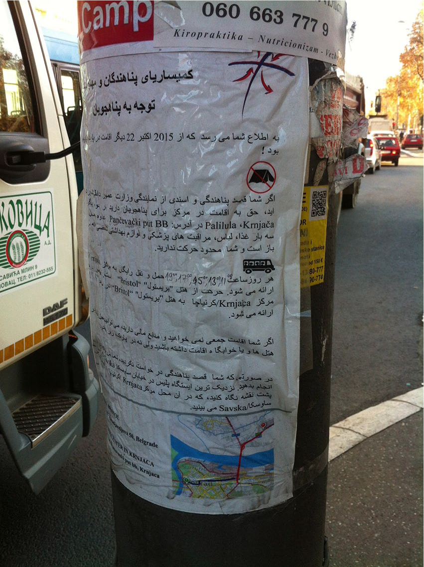
A flyer forbidding camping in a Belgrade park. The flyer also shows directions to the nearest refugee camp. Belgrade, November 2015.
Official signs not only acknowledge the presence of displaced people, but also attempt to conduct them away from urban centres towards spaces of enclosure or points of exit. In 2015, for instance, the central bus station in Belgrade displayed posters with only three place names (in Serbian and Arabic). The three places – Subotica, Erdevik and Kanjiza – are significant mostly as exit points out of Serbia. This seemingly banal act of signposting actually reflects a broader development, representing visually the haphazard European border policies that led to the establishment of the ‘Balkan Corridor’ in 2015 (El-Shaarawi and Razsa, 2019). As El-Shaarawi and Razsa (2019: 94) note, the ‘Balkan Route’ turned into the ‘Balkan Corridor’ when governments, starting with Serbia and Northern Macedonia in 2015, facilitated the onward movement of people across their territories by providing documents and transport. Whilst such signage became a part of the visual landscape that reinforced the idea of the ‘Balkan Route’ as a space for transit and Serbia as ‘helpful’, in reality, as Stojic Mitrović and Vilenica (2019) note, the route itself became a part of an externalised EU border that, rather than facilitating transit, produced immobilities and circulatory movements as migrants were pushed from one regional border to another.
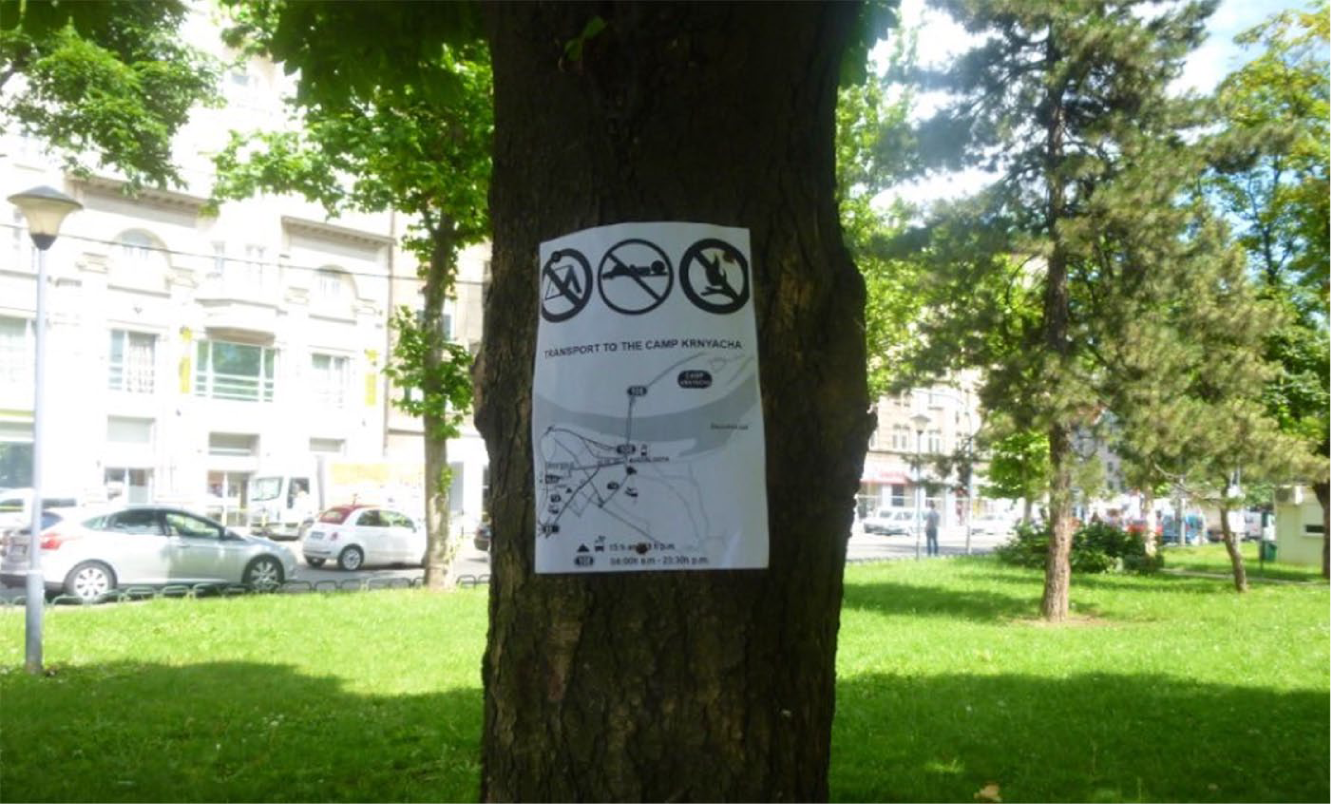
Local authorities’ policing of the refugee presence through visual means is ‘place-based’, dividing and policing physical space (Nicholls et al., 2013: 5). This is often depicted on maps directed at refugees, as seen, for instance, in Figures 2, 3 and 4. Indeed, maps become a crucial way of capturing micropolitics (c.f. Solomon and Steele, 2017) of border management, since they represent places only in terms of what authorities want refugees to see – camps and roads leading to camps. Maps created by various local authorities (Figure 2, for instance) only tend to show camps or asylum registration offices, without providing any additional local detail for context. On a squatted building in Thessaloniki, we found precisely such a map, directing refugees in English and Arabic towards the Greek Asylum Services registration office, but providing only the bare minimum information, and using an image typical of maps produced by local, national and EU authorities – an arrow pointing only in a single direction to the camp, or asylum registration office, but never anywhere else (from the camp to the train station, for instance).
Despite maps being produced by different local and national authorities they share common elements: using images presumed to be universal (directional arrows, campsites) and showing only spaces deemed ‘appropriate’ for refugees, whilst blocking out the rest of the city and rendering invisible core services such as hospitals, aid points or transport hubs. Maps are a crucial tool of place-making, and they represent the city, the locality and refugees’ needs only in terms of the camp, visually constructing a world refugees are ‘allowed’ to inhabit. Maps, in other words, do not show what refugees need to see, but rather what local authorities want them to see. By focusing only on camps and asylum registration centres, these visual and cartographic representations of transit cities like Belgrade reflect the macropolitical structures and policies of refugee reception. As borders around Serbia ‘closed’, the policies shifted from assisting transit to encampment, particularly as EU funding became associated primarily with refugees residing in camps (see Obradovic-Wochnik, 2018). In that sense, maps that initially appear ‘helpful’ are a visual representation of encampment policies that restrict the refugees local, as well as cross-border, mobility. Almost all major reception centres and camps in the region (with the exception of the Vathy reception centre on Samos), are set well away from urban or commercial centres and maps are hence indicative of how attempts are made continually to segregate refugee populations from local populations and specific sites.
The changes in border policies across Europe and the move away from transit associated with the Balkan Corridor (El-Shaarawi and Razsa, 2019) are also reflected in the physical presence and appearance of official signs. In 2015, when large numbers of refugees started arriving in Belgrade, for instance, the first official signs were often low-tech, A4 or A3 sized pieces of paper stuck or stapled to lampposts and trees. They then became more polished, made of metal and more permanent as borders around Serbia ‘closed’, and the country itself became a site of more permanent settlement rather than a transit country.
States and authorities also use everyday and banal objects and visual representations to project their own dominance and control over certain spaces. In one example, we found in a Serbian reception camp posters produced by the German Federal Foreign Office with the message ‘#rumours about Germany, facts for migrants (see Figure 5): Who is allowed to stay in Germany and who is not?’. The poster has a corresponding flyer: ‘Don’t listen to rumours about Germany, here are the facts’. Both are banal illustrations of Parker et al.’s (2009) fluid borders, whereby a Serbian camp is redrawn as a place in which the German border is enforced. However, likewise, it is a kind of bordering that relies on people being self-regulating subjects, being ‘governed at a distance’ (Barry et al., 1996). Signs and posters do the political work of the state and its authorities without requiring a physical presence. They allow the state’s rules to be made visible and thus become a means through which the state is visualised, whilst state authorities themselves remain invisible and seemingly benign.
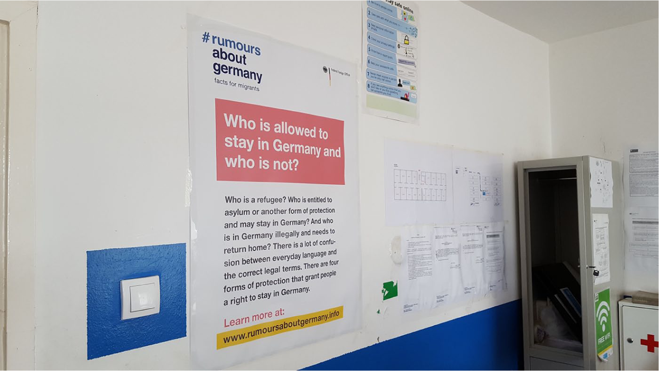
‘#rumours about Germany’ poster at a Serbian reception centre (outskirts of Belgrade), June 2017.
In another example, a park in central Belgrade was used as an important place of aid distribution, access to aid, practical help and solidarity. The activists at the core of the park’s activities were eventually evicted by the authorities and the refugee networks dispersed, particularly after city authorities fenced off the park and increased surveillance (see Obradovic-Wochnik, 2018). Soon after this, the city authorities put up multiple ‘Keep off the grass’ signs in English, Serbian, Arabic and Farsi (Figure 6) around the perimeter of the park.
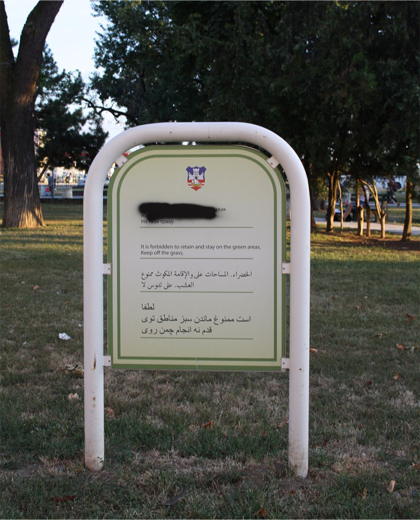
Keep off the grass signs in Serbian (crossed out), English, Farsi and Arabic. Central Belgrade, July 2017.
The sign is an example of the banal ‘thing-politics’ (Latour and Weibel, 2005): seemingly unobjectionable, dull and ordinary, but viewed in relation to refugee movements across the region, it immediately becomes political and politicised and crucial to place-making, in which the local authorities attempted to re-assert their dominance over the space and its evicted occupants. It is clear that this particular set of ‘Keep off the grass’ signs is not directed at all city dwellers, but only a specific group of people. The translations on the sign speak to its broader politics. Whilst the English is mistranslated and perhaps misses the original point – ‘It is forbidden to retain and stay on the green areas. Keep off the grass’, the original Serbian can actually translate into ‘Loitering and long-term stays are forbidden. Keep off the grass’. Not only does ‘long-term stay’ have echoes of asylum regimes, but also it is very clear that this is not an actual ‘Keep off the grass’ sign but rather an explicit directive to let people know that their presence is seen as ‘loitering’. Feigenbaum (2013: 18) calls this characteristic a material-communicative significance. Writing about protest camps, Feigenbaum (2013: 15) suggests that they are not only physical spaces – their significance as places of protest is also made through specific objects, such as tents, which have expressive qualities because they are ‘entangled in resistance’. The ‘Keep off the grass’ sign directed specifically at Arabic- and Farsi-speaking communities in Serbia is similarly entangled in border management and security. Local authorities have often attempted to patrol this park under the pretext of intercepting smugglers and traffickers, or moving refugees from the park to the camps (author interviews, Belgrade 2017 and 2017) and the signs allow them an additional pretext for removing people from public spaces.
‘No borders, no cops, no problems’: Navigating the route with informal help
In certain parts of Athens, ‘No borders, no cops, no problems’ graffiti is ubiquitous, and ‘Refugees welcome’ was spray painted across parts of central Belgrade in 2015 before being removed by local authorities. However, graffiti protesting border policies – an important place-making activity communicating solidarity in neighbourhoods welcoming refugees – is not the only type of activist-produced communication. Found alongside graffiti and official signs and maps are various unofficial signs and notices produced by activists. They often point refugees to aid, information or legal help and help re-make public spaces into sites and places of support. They contest the mobility politics of official signs, maps and camp directions by subverting their attempts at regulating the refugee presence in cities or commercial centres. Unofficial signs are navigation tools, but they are also used to enforce rules in the parallel system of refugee housing, to provide safe guarding instructions, evacuation procedures and regulate the number of people living in squats. Unofficial signs look especially ‘banal’ and innocuous, as they are often homemade and low-budget, taped, photocopied and produced with few resources.
The primary function of unofficial posters and notices is to direct refugees to crucial services that are often concealed by official signage. Whilst official signage directs refugees away from places, and does not provide useful information (hospitals, cash machines or support services), unofficial signage directs refugees towards things, especially core support services or border crossing information (Figures 7 and 8), transport schedules, food services and legal aid.
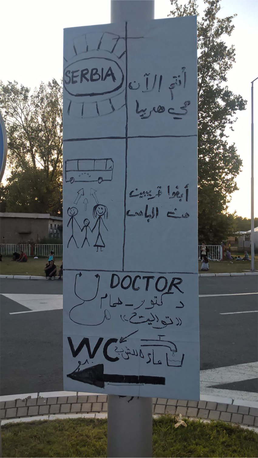
Handwritten notice in front of the official, state-run Adasevci refugee camp (August 2016).
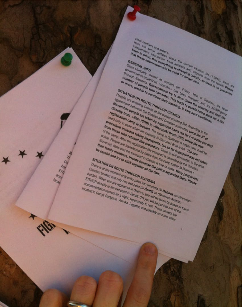
Activist leaflets with route maps and border crossing information, central Belgrade, November 2015.
A particularly jarring observation that these seemingly banal informal signs reveal about the macropolitical is just how much of the aid effort in transit (and other parts of the route) is borne by activists (see, for instance, Papataxiarchis, 2016). Official EU narratives are keen to emphasise that ‘the crisis’ is ‘over’ but that ‘structural problems remain’ (The Guardian, 2019). The view of ‘the crisis’ from the ground up reveals that the ‘structural problems’ are in fact serious humanitarian emergencies and neglect (see Davies et al., 2017; author interviews, 2019, Samos and Belgrade), despite the vast amounts of funding spent by the EU in transit countries. Since 2015, the European Commission has allocated €480m to Greece, in addition to the €561m already allocated through national assistance programmes between 2014 and 2020, in addition to another €650m made available through the Emergency Support Instrument between 2016 and 2018 (European Commission, 2018). However, the emphasis of the funding is on ‘improv[ing] reception capacities’, integration ‘at local and regional levels’, increasing the ‘effectiveness of return programmes’ and ‘uniform and high level control of the external borders’ (European Commission, 2018). This means that refugees outside of the formal reception centre/camp system struggle to access aid, and that in many parts of the route, such as Samos, Athens and Belgrade, even formal refugee camps in receipt of EU funds nonetheless still rely on volunteers and NGOs to provide key services, including meals, showers and non-food aid (author interview, Samos, 2019).
Unofficial signs and notices seen all over the ‘Balkan Route’ highlight the extent to which activist networks and unpaid labour mediate the effects of ‘closed borders’, whilst simultaneously fighting against their own criminalisation. Throughout our fieldwork, we visited multiple activist-led sites in Serbia and Greece where small groups of people help manage alternative accommodation or cook food for several hundred people. Such places, despite often being informal and thus not regulated in the same way as a NGO-run canteen would be, for instance, had signs, posters and notices setting out house rules or regulating food preparation and kitchen health and safety. We were particularly intrigued by one such kitchen, set up outdoors in the courtyard of a house in Northern Serbia, which did not have adequate premises for food preparation but nonetheless had multiple handwritten signs for precise measurements for chai (tea) ingredients and instructions on the correct storage of used dish towels and old food (Figure 9). This seemingly banal thing initially caught our attention because it illustrated the scale of the aid effort undertaken by unpaid activists and private donors – the group, without adequate facilities or funding, was making 150 portions of chai each day (in addition to 150 meals served twice daily) to be distributed to refugees living without shelter in the so-called ‘jungle’ between the Serbian–Croatian border.
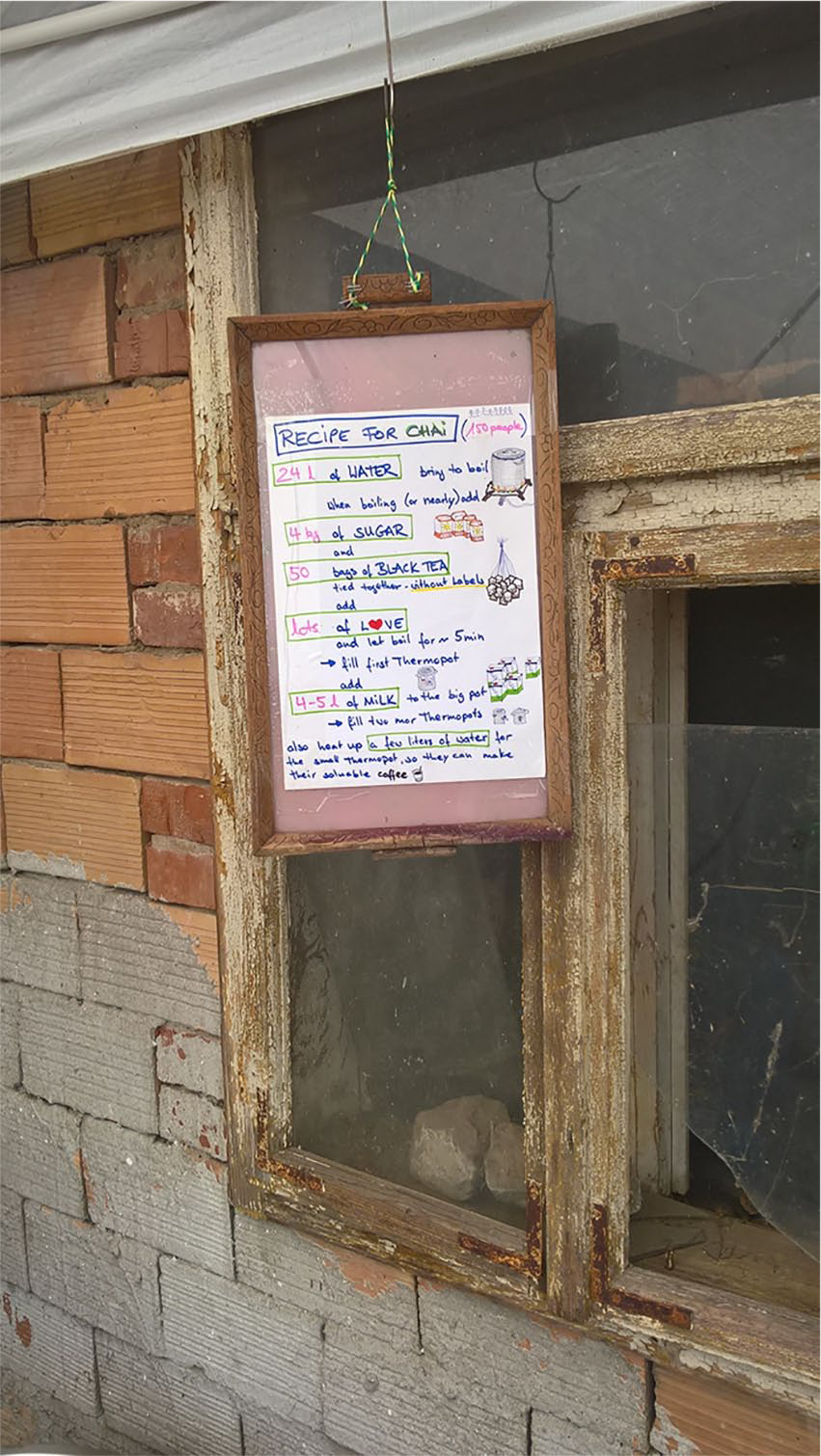
Recipe for chai, activist-run kitchen, Northern Serbia, near the Serbia-Croatia border, July 2017.
Against this background, signs, posters and notices found in sites providing informal aid tell us a great deal about the macrostructures governing not just EU borders, but also how those same systems try to govern, criminalise and curtail informal aid and solidarity (Fekete, 2018; Tazzioli and Walters, 2019), whist also relying on the services and free labour provided by volunteers. Informal aid providers are ‘governed at a distance’ (Barry et al., 1996); they are in a constant struggle with authorities who attempt to shut down informal aid providers, and so they internalise the rules normally associated with state regulation in order to create safe working and living environments but also to avoid criminalisation, eviction or the curtailment of their services. Multiple interviews and site visits suggest that sites themselves are not necessarily unsafe or unsanitary, but rather that local authorities may use health and safety regulations as an excuse for shutting down a service provider. For instance, one Athens refugee squat in which activists and residents cooperate to run the accommodation, and that sees itself as independent of state regulation, nonetheless bears a handwritten ‘Rules for Safeguarding’ poster taped to the door. A similar sign, ‘Fire Evacuation procedures’, appeared on the door of a volunteer-run kitchen in Belgrade (Figure 10). We also found a sign outside of another Athenian squat, which informed potential residents that the accommodation is full in an attempt to control overcrowding (Figure 11); two other squats in Athens also told us that they regulate the numbers of residents and are forced to turn people away daily. In contrast, many official (EU-funded) and thus purportedly regulated reception centres do not appear to control overcrowding in the same way. In just one example, in January 2019, we learned that the Vathy Reception Centre in Samos hosted between 4000 and 5000 refugees in accommodation intended for 650 (Bird and Beattie, 2019; author interview, Samos, 2019), mainly as a result of the EU–Turkey agreement, which now sees people trapped on the islands on which they arrive.
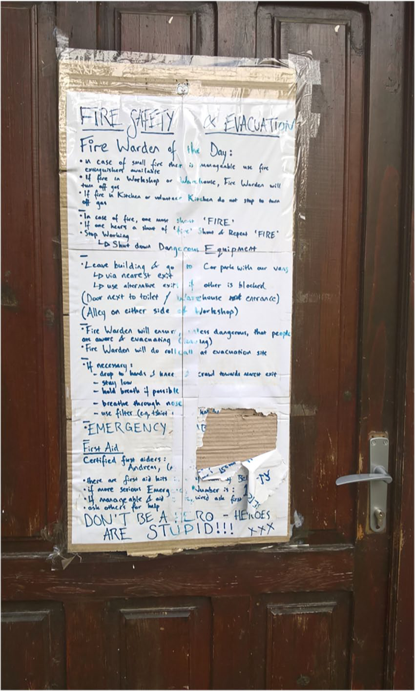
Fire evacuation procedure, volunteer-run kitchen, Belgrade, June 2017.
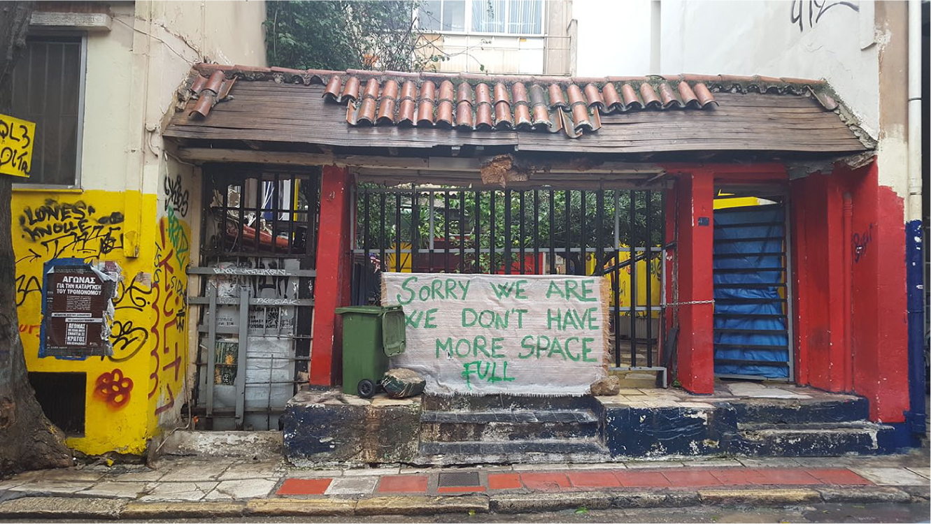
‘Sorry, full’ sign outside a squat in Exarchia, January 2019.
Conclusion
We set out to investigate the spatial/visual and material convergences captured by the politics of seemingly banal things (Salter, 2016) to discuss both the visuality of things like posters, flyers and signs, as well as their locations and materiality, each ‘thing’ reflecting more broadly on the macropolitics of European borders. We follow King (2016: 15) in thinking of borders as ‘physical and imagined; material and experiential’. Borders, King (2016: 15) argues, are ‘practices that are reproduced every time we decide who is allowed in and who isn’t’, and we sought to show how borders and their exclusions are imagined and represented through banal, everyday objects used to communicate to migrant populations across Europe.
By engaging with these examples, we contribute to the growing field of IR that engages with the politics of the everyday. By examining how the everyday and the seemingly banal interact (Salter, 2016) we excavate the power relations and processes of bordering that exist within urban landscapes that may otherwise go unnoticed and ignored.
Official and activist-produced objects, signs and posters interact to show not just struggles over public spaces and their entanglements in migratory routes and border politics (see also Obradovic-Wochnik, 2018), but they also attempt at regulating and gaining control over specific sites in seemingly non-politicised ways; in particular, official signs, which are made to look like ‘just’ directions to a camp, and ‘just’ keep off the grass signs, but are in fact concerned with regaining control over public spaces, and directing and governing people at a distance (Barry et al., 1996). Everyday signage thus allows states implicated in European border security to visually regulate and govern spaces and places, whilst appearing ‘benign’, concealing the actual treatment of refugees enacted through exclusionary border policies and camp overcrowding. If we consider all these everyday signs, posters, notices and flyers in relation to the refugee ‘crisis’ more broadly, then we can argue that not only are they doing political work but that they themselves become political objects (Latour and Weibel, 2005).
As the EU narrative of ‘crisis’ evolves, the visual, spatial and material representations we observed help us to track a narrative of the everyday lived experience of the people existing within these landscapes and the temporary lives they have made for themselves on the Balkan Route(s). In doing so we have not engaged with questions of how communications are received by different groups of refugees, but rather the ways in which they have been communicated to and the intentions for driving the everyday lives of refugees that lie behind the seemingly banal. In this way, we are helped by activist-produced maps, signs and flyers that draw our attention to the deficits of EU and state-level provision. In engaging with both official and unofficial signs in Serbia and Greece we are engaging with not only state-level directives but also those at the EU level. That being said, we are cautious not to over-generalise the lessons that can be learnt from these specific locations to broader discussions of the ‘refugee crisis’. Whilst certain similarities in approach exist between different states and localities, we only have to look at how policy and practices are implemented differently in different states to recognise the risk of generalising from one location to another, for example, the differences in approach to reception centres in Italy and Greece (Dimitriadi, 2017).
We suggest that walking enables us to understand the relevance of signs and visuals in specific sites and the roles they play in deepening our grasp of the micropolitical. In making this observation we argue that the seemingly banal visual urban landscape ought to be attended to as an extension of broader bordering and governing practices as well as being a representation of the work of activists in challenging the state and meeting the needs of refugees that have otherwise not been met.
Footnotes
Acknowledgements
Earlier versions of this paper were presented at the British International Studies Association Conference, June 2018. We are grateful to the panel attendees and especially our discussant Laura J. Shepherd for the insightful and encouraging comments. The paper was also presented at the Matariki Meeting, at Durham University in September 2018, and the Borders, Mobilities and Cultural Encounters Research Area at the University of Eastern Finland; we gratefully acknowledge the audience feedback and comments. We would also like to thank Annika Bjorkdahl and the Cooperation and Conflict team, and our colleagues Amanda Russell Beattie and Patrycja Rozbicka, part of the IR Aesthetics collective, for their encouragement and support.
Funding
This research was supported by funding from Aston Centre for Europe, Aston University and the University of Liverpool Early Career and Returners Grant.