
Abstract
Rebels can comply with international law during a conflict by not violating international borders, yet strategic goals may incentivize rebels to violate these borders. When do international borders affect the spatial and temporal distribution of rebel activity in a conflict setting? I theorize rebels have an incentive to refrain from violating borders when doing so will reduce their international legitimacy. When international legitimacy is a less important goal, rebels will be more likely to violate borders. I test this claim in the context of the 1948 War in Mandate Palestine by exploiting a quasi-natural experiment in how the 1947 UN partition line was drawn. Using an original dataset on over 1,000 Palestinian villages from British colonial documents and an atlas of aerial photographs of Palestine, I use a geographic regression discontinuity design to see how the UN partition line affected the location and timing of depopulated villages during the war. The results show that villages in areas that the UN assigned to the future Israeli state as part of the 1947 partition plan were more likely to be conquered before Israel received recognition. These findings have important implications for understanding where and when rebels target areas and shed new light on important dynamics of the 1948 War in Palestine.
Introduction
How do incentives to comply with international law affect rebel behavior within a conflict? Many rebel groups face incentives to comply with international law to increase their legitimacy in the eyes of the international community. However, compliance is costly. Military and strategic incentives pressure rebel groups to attack civilians and expand their territorial control. International law and norms impose costs on this behavior, which is why rebels that care about legitimacy are less likely to attack civilians. Existing research has examined why some rebels comply with international law, and why some do not. Less is known about how incentives to comply affect the spatial and temporal distribution of violence within a conflict. This article argues that the incentive to comply with international law can affect where and when rebels select territory for conquest. Rebels seeking legitimacy will refrain from violating an international border as a way to signal their commitment to international law and garner international legitimacy.
I present a theory on how borders and the internationally recognized right to rule territory can affect where rebels will target areas for conquest. I argue that rebels who care about international legitimacy have an incentive to consolidate their rule through violence in territory where the right to rule is higher – that is, on ‘their’ side of the border. These rebels will refrain from attacking in areas where there is less legitimacy as a signal to the international community that they respect international law. When the need for international legitimacy is lower, these restraints become less important to rebel decisionmaking. The normative and legal aspect of borders can restrain the geographic spread of rebel violence. This article contributes to our understanding of how the international system can affect rebel behavior by showing how incentives for rebels to comply with international law can vary across space and time within a conflict.
Since borders are ‘bundled treatments’ and can affect conflict via a wide range of mechanisms, providing support for my argument requires a case where a border only matters for normative and legal reasons. Fortunately, the UN’s involvement in the Palestine Mandate provides such a case. I test my theory by examining how the international border drawn by the UN affected rebel behavior during the 1947–48 war in Mandate Palestine. In 1947 the UN attempted to prevent a conflict by partitioning Palestine into separate Jewish and Arab states. The UN partition line was not implemented. The UN never sent any troops, material, or international observers, nor was there a plan to enforce the partition plan (Khalidi, 1988: 12). I argue that the partition line still restrained the Israelis because the Israelis sought to comply with international law as a way to facilitate international recognition. My results show that the UN partition line affected the course of violence in Palestine despite being lines on a map drawn in Geneva.
To see the effect of the international border on rebel behavior, I use a geographic regression discontinuity design (Keele & Titiunik, 2015). This design compares geographically proximate villages on either side of the border. I argue that the partition line constituted a quasi-natural experiment (Dunning, 2012; Keele & Titiunik, 2016). The committee in charge of answering the ‘Palestine Question’ – the United Nations Special Committee on Palestine (UNSCOP) – remained ignorant of many of the relevant facts on the ground and the characteristics of individual Palestinian villages. This occurred because the British refused to share the village census they conducted in 1945, which contained detailed information on all villages and their population distribution. This ensured that the partition line was drawn irrespective of any characteristic of the individual villages and makes it very likely that villages located around the border only differed based on which side of the border they were on. In many ways, the 1948 War is unique. However, the core dynamics of the Israelis forcibly expelling non-coethnics in the process of controlling more territory is common to many forms of civil war (Lichtenheld, 2020). While the UN is no longer in the habit of drawing lines between populations, examining the effects of this process in detail highlights important dynamics of civil wars that may be present in other conflicts where rebels seek to control territory and care about complying with international law.
I use historical data on massacres, exoduses, and occupation dates on over 1,000 villages in Mandate Palestine during the war to compare villages on either side of the partition line. Using an atlas compiled from aerial photographs taken by the British Royal Air Force, I geocoded nearly every village in Mandate Palestine and computed its distance to the imagined partition line. In addition, I used British colonial reports to gather data on the ethnic composition and agricultural quality of each village. Analyses of this dataset using a number of methods shows that villages in the future Jewish State were (1) more likely to be occupied by Jewish forces before the Mandate was set to expire (and when Israel formally declared its independence) and (2) more likely to experience a forcible expulsion of the Arab population. This shows that the Israelis refrained from violating the international border before statehood was achieved but became more willing to do so after receiving international recognition. This is important because it provides notable intragroup variation in the incentives to comply with international law.
By showing that the UN’s behavior had a substantial impact on the course of the conflict, this work engages with longstanding debates in the International Relations literature about the role of international organizations and more recent work on rebel diplomacy (Coggins, 2015; Huang, 2016). Realist scholars argue that IOs are merely tools used by powerful states to achieve their goals (Mearsheimer, 1994). I show how this logic applies to conflict between rebel groups. While the UN debated how to solve the Palestine problem, the Israelis engaged in sustained lobbying efforts. The Palestinian leadership chose to boycott the UN. The result was a partition plan that was favorable to the Israelis and disastrous to the Palestinians. Successful diplomacy by the Israelis, in turn, provided them with a blueprint for their conduct during the war. Since the UN had no plans to actually implement the partition, the Israelis decided to implement the plan themselves. 1 Rather than secure legitimacy through public goods provision (Stewart, 2018), the Israelis lobbied the UN to increase their claim to land and further their goals.
Historical background on Mandate Palestine
I chose this case to examine the effect of borders on conflict processes for three reasons. First, the historical data compiled are incredibly accurate and granular, which is essential for the RDD analysis. The second reason is that there is variation in the need for international recognition among the Israelis. Once they received de facto recognition by the United States and USSR, it was exceedingly unlikely that it would be revoked by Israeli actions, and this enables the comparison of Israeli behavior before and after recognition. Third, while the 1948 war has been intensely studied by historians and scholars of the Middle East, it has been largely ignored for political scientists. While there are challenges to studying a war that is viewed as sui generis, doing so can push our theories further and generate new insights. Below I present important background information about Mandate Palestine and the 1948 war.
Britain conquered the territories of Palestine and Transjordan in 1920 after the fall of the Ottoman Empire. After World War II ended, communal tensions between Arabs and Jews increased, and Britain sought help from the UN to adjudicate the dispute. On 29 November 1947, the UN General Assembly passed Resolution 181. This established the commission that would inherit the Mandatory government from the British and divide the land to be ruled separately by Arabs and Jews. Immediately after the resolution was passed, Arabs feared that process of displacement of their land would accelerate, and responded with violence against Jews. Reprisals ensued. For the first few months of the conflict, the majority of violence occurred near the main ethnically mixed towns (Morris, 2004b). By January the conflict moved to rural areas and consisted of organized armed fighting between Jews and Arabs. Attacks against Arab villages usually consisted of the Haganah (the precursor to the Israeli Defense Forces) surrounding a village and threatening to search it for arms and combatants. The Haganah would then search the village, forcibly expel the population, and destroy the village in order to prevent it from being used later on as a place to stage more attacks (Morris, 2004b: 165–170). By April 1948, nearly all the British police, along with about half of the military forces, had left the colony (Tauber, 2012). Britain, not willing to cooperate with the UN, announced that it would end the mandate on 15 May 1948. At midnight on 14 May 1948, the State of Israel declared its independence. By this time, hundreds of thousands of Palestinians sought refuge in the nearby Arab states. After months of smaller-scale clashes between Israel and the Arab states, Egypt, Syria, Jordan, and Iraq responded by invading Palestine on 15 May 1948.
The UN borders played an important role in the course of violence and in the recognition of the state of Israel after independence was declared. During the war, President Truman made it clear to the Israeli leadership that recognition was not guaranteed, and that excessive violence could jeopardize US recognition. In December 1947, Truman told the Israeli leadership that ‘the vote in the United Nations is only the beginning and the Jews must now display tolerance and consideration for the other people in Palestine with whom they will necessarily have to be neighbors’ (Morris, 2004a: 113). The formal request for recognition of Israel by the United States was drafted by Clark Clifford, Truman’s adviser, and the diplomat Eliahu Epstein, who would later become Israel’s first ambassador to the United States. Clifford advised Epstein to tout that the new state claimed ‘nothing beyond the boundaries outlined in the UN resolution of 29 November 1947, because those boundaries were the only ones which had been agreed to by everyone’ (Gendzier, 2015: 165). Epstein opened the formal request for recognition to Truman with the line, ‘I have the honor to notify you that the state of Israel has been proclaimed as an independent republic within frontiers approved by the General Assembly of the United Nations in its Resolution of 29 November 1947’ (Gendzier, 2015: 165).
Borders played a prominent role in Israel’s declaration of independence. On 12 May 1948, the National Administration (the pre-cursor to the Israeli parliament) discussed the declaration. Felix Rosenbleuth argued that no declaration was needed because the borders of the state had been affirmed by the November UN resolution. Ben-Gurion disagreed, saying ‘[w]e accepted the UN resolution, but the Arabs did not’ (Ben-Gurion, 1971: 76).
Ben-Gurion also argued that borders should not be mentioned in the declaration since this would present difficulties in the future if Israel captured more territory. Ben-Gurion asked: ‘If we defeat [the Arabs] and capture western Galilee or territory on both sides of the road to Jerusalem, these areas will become part of the State. Why should we obligate ourselves to accept boundaries that the Arabs don’t accept in any case?’ (Ben-Gurion, 1971: 77). The result was a declaration of Israel’s independence without any mention of the state’s borders.
The declaration, however, did refer to the UN partition plan. It mentioned that the November resolution ‘required the inhabitants themselves to take all measures necessary on their part to carry out the resolution’ (Ben-Gurion, 1971: 80). Moreover, paragraph 14 read: ‘The State of Israel will be prepared to cooperate with the organs and representatives of the United Nations in carrying out the General Assembly resolution of 29 November 1947’ (Ben-Gurion, 1971: 80). Evidence suggests that these references were designed for international audiences. When Ben-Gurion read the statement formally declaring Israel’s independence at midnight on 14 May, he eliminated any reference to the UN resolution (Gendzier, 2015: 165). Israel’s battlefield successes made it likely that more fighting would lead to more territory, and Ben-Gurion wanted to make it clear to domestic audiences that the UN border would cease to contain the State of Israel now that they had achieved international recognition.
International law, recognition, and the distribution of violence
A number of works have studied the ways in which rebels can gain international legitimacy. Stewart (2018) argues that secessionists are more likely to provide public goods to residents of the area in which the secessionist group seeks to achieve sovereignty. By mimicking states, secessionist rebels become more legitimate in the eyes of the international community. Rebels can also adhere to other norms, such as refraining from using child soldiers (Lasley & Thyne, 2015) or avoiding civilian casualties (Fazal, 2018) to signal their legitimacy. While international recognition is necessary for secessionists, other types of rebel groups strategically adhere to international norms and laws when they seek legitimacy from diaspora groups, the international community, or great power patrons (Jo, 2015). In general, legitimacy-seeking rebels are more likely to adhere to international law.
I argue that rebels can also refrain from committing violence across international borders to signal their legitimacy. Rebels may limit operations in foreign territory for a whole host of reasons. Crossing international borders risks third-party intervention, the civilian population in foreign territory is more difficult to control (Stewart & Liou, 2017), or there may simply be walls or geographic barriers that make it physically more difficult for troops to cross borders (Carter & Poast, 2017). Lines may also be drawn along previous administrative borders and may simply reflect pre-existing divisions, as in the case of Northern Ireland (Waterman, 1987). In the same way rebels comply with international law by avoiding the targeting of civilians, rebels may comply with international law by refraining from violating borders.
Legitimacy-seeking rebels balance observing international law with tactical pressures regarding the deployment of violence. It may be militarily advantageous to use land mines; however, doing so violates international law and reduces international legitimacy and support for the rebels – winning the military battle and losing the political war (Jo, 2015). This same trade-off exists for rebels seeking to control and conquer territory. Territorial control confers a number of benefits for rebel groups, including resource extraction, information from civilians, and control over a population that could be used to recruit more fighters (Rubin, 2020). The more territory that a rebel group controls, the more resources it has to combat the state. For secessionist rebels, this incentive may be stronger since rebel territorial control means that the parent state lacks effective control over the area that the rebel group controls, further weakening the parent state. Secessionists face even stronger incentives to expand their reach in wars where the territory controlled by the winner becomes the borders of the new state. However, secessionists also face constraints: great power support is a key determinant of international recognition (Coggins, 2014), and great powers may be reluctant to recognize a rebel group that disregards international norms and laws.
The territorial integrity norm has been a robust feature of the postwar international system that sanctions states and non-state actors for violating borders. Scholars have defined the territorial integrity norm as the shared understanding that military conquests by states of another state’s territory is prohibited (Zacher, 2001). As with many norms, state and nonstate actors have violated the proscriptions of the territorial integrity norm. Why may rebels violate this norm and cross international borders? There are two reasons: one is that increased territorial control confers numerous benefits to rebel groups, and if a rebel group has the opportunity and ability to capture territory that straddles an international border, the incentives to do so may outweigh the cost they will pay for violating the border (Rubin, 2020). The opportunity to evade government repression and mobilize supporters in neighboring countries can also pressure rebels to establish safe havens across an international border (Salehyan, 2009).
Despite the benefits of violating borders and expanding territorial control, many rebels refrain from doing so. Why? The territorial integrity norm is codified in international law, and some rebel groups have strong incentives to comply with international law. Jo (2015) theorizes that legitimacy-seeking rebel groups (rebels whose external sponsors care about human rights) are more likely to comply with international law than legitimacy-indifferent groups (rebels who care more about military gains). For example, Fazal (2018) argues that secessionist rebels, since they need international recognition to win, are much more likely to comply with international law and reduce violence against civilians. Stanton (2016) argues that rebels who have a broad international constituency are more likely to exercise restraint and to comply with international law.
Thus, the territorial integrity norm exists and sanctions violations of international borders. Rebels have a military incentive to violate borders because doing so helps expand their territorial reach and may provide opportunities to evade repression. However, there are constraints on rebels for violating borders. Rebels who care about legitimacy will engage in costly actions to comply with international law in order to garner international support. Scholars have examined some of these costly actions, such as refraining from killing civilians, building schools, and allowing international observers in rebel detention centers. I theorize that since violating an international border is a form of violating international law, legitimacy-seeking rebels will refrain from violating a border as long as the benefits of international legitimacy outweigh the costs of restraint. When the costs of restraint decrease, rebels, even though they still care about legitimacy, will be more likely to violate a border since the costs are lower and the incentives to expand their territory remain.
Highlighting these incentives also helps delineate the scope conditions of my theory. An international constituency whose decision to support or not support a rebel group must also be sensitive to the rebel group’s adherence to international law. In other words, if international support or the potential for recognition is a highly likely outcome regardless of rebel behavior, then rebels will not face a tension between expanding their territorial reach and violating international borders, since they will have international support regardless of their behavior. This scenario likely occurred during the height of the Cold War when international support from the USA and USSR was more likely to be driven by ideological or great power security interests rather than rebel group behavior. The theory also applies to rebels – that is, organized non-state actors that use violence as a political tool. Before they became a de facto state, the Haganah and the Israeli leadership constituted a rebel group. They did not have a state, they employed violence as a political tool, and there was a clear organizational structure rather than an undifferentiated group.
The other important scope condition is the ability and incentive for rebels to expand their territorial control. Rebels that are too weak to expand their territorial control will be restrained by material, not normative, factors. While the contours of the homeland may limit the territorial ambitions of secessionist groups, those contours are endogenous to political and material factors and may shrink or expand based on the strength of the rebel group (Shelef, 2020). Generally, my argument applies more to secessionist groups than revolutionary rebel groups, since international legitimacy and territorial control both facilitate international recognition (the main goal of secessionists). Many revolutionary groups also strive to control territory and may benefit from substantial support from other states, and thus may also respect international borders when the costs of foregoing international support are higher than the benefits from controlling territory.
Since respecting international borders is costly in cases where there is an incentive to expand rebel control into territory across borders, I theorize that rebels will refrain from violating borders when the incentive to respect borders is high. When the incentive to respect borders is lower, and strategic pressures to expand control remain constant, rebels will be more likely to violate a border. In the context of the 1948 War in Mandate Palestine, this theory generates a number of testable hypotheses.
Violence in the context of the civil conflict of Mandate Palestine in 1948 primarily revolved around the expulsion of the non-coethnic populations, and resistance to these expulsion efforts. This was especially true in rural areas, where ethnically mixed villages were rare. While there were cases of nonviolent depopulation of Palestinian civilians (either through a lack of willingness to resist Israeli demands or pre-emptive fleeing), my focus here is on violent depopulation since conducting violence outside of the lines violates international law. To be sure, international law as applied to Palestine was and remains highly contested, with many Muslim states voting against the UNSCOP resolution. The relevant point is not the precise legality of the legal regime of partition, but the power of the states upholding the legal regime.
At its most basic, the theory predicts that rebels will refrain from committing violence across international borders even when those borders only represent legal institutions as a way to signal adherence to international law. For the Israelis, this signal was primarily sent to two main actors – the United States and the USSR – since their decision to recognize the new Israeli government would have the biggest impact on securing widespread international recognition of their state. Although other states mattered (Shlaim, 1988: 155), these great powers acted as the relevant international constituency.
Since the territory within the UN borders was the territory where the Israelis had an internationally recognized right to rule and violence committed in this territory was less likely to reduce international legitimacy, this generates the following hypothesis:
H1: Villages within the territory allotted to the future Israeli state by the UN should be more likely to experience the violent expulsion of the Arab population than villages outside the territory allotted to the future Israeli state.
The theory also predicts that when the incentive to cultivate international legitimacy is higher, rebels will be more likely to respect international law. In the context of the 1948 war, there was important variation in the need for international legitimacy. The Israelis received international recognition for their state on 15 May 1948. Before that time, their incentive to respect international law was quite high, since their main goal was achieving statehood. After that time, the incentive to respect international law was lower, since it was highly unlikely that both the USA and USSR would rescind their very public declarations recognizing the state of Israel. In the words of Yoav Gelber, after 15 May ‘the Israelis’ previous restraints about crossing the UN line disappeared’ (Gelber, 2001: 8).
Thus we should see variation in the propensity for the Israelis to violate the border across time. The Israelis should be less likely to violate the border before receiving international recognition. The border should have little effect on Israeli depopulation efforts after recognition. This generates the following hypothesis:
H2: Before 15 May 1948, villages within the territory allotted to the future Israeli state by the UN should be more likely to experience the violent expulsion of the Arab population than villages outside the territory allotted to the future Israeli state. After 15 May 1948 the border should have no effect on the distribution of violence.
It is exceedingly unlikely (if not impossible) for states to renege on the international recognition of another state. The Israelis thus had an incentive to respect international norms until they got what they wanted. After that point, violating norms, while not without penalty, would not result in the Israelis being unable to achieve their main goal (statehood). This incentive structure, where the main benefit of adhering to international norms cannot be withdrawn after the benefit is dispersed, may encourage stronger compliance with norms, but that compliance may be temporally bounded. 2 This partly explains why secessionist rebels are more likely to comply with a variety of norms that regulate armed combat.
To be sure, international recognition was not the only relevant change during the war that occurred on 15 May 1948. In addition to de facto recognition by the USSR and the USA, the British formally withdrew from Palestine (although they substantially reduced their presence in the beginning of the year and there was very little chance of any further military involvement (Tauber, 2012)). The Arab states also launched their attack, with Egypt invading Gaza and the Jordanian Army crossing the bridge into Jericho. Most of this fighting took place away from the borders of Israel (and in fact occurred near the borders of Palestine and the respective Arab states). As David Tal writes, the fighting between Israel and Jordan ‘was in many respects a war over Jerusalem’ (Tal, 2004: 201). While formal British withdrawal and the Arab invasion affected the dynamics of the war, it is unlikely that these factors explain the entirety of Israeli behavior at the 1947 border. Below, I explain how I test these hypotheses.
Research design
To examine how the UN border affected the distribution of violence in the 1948 war, I compare villages in Mandate Palestine on either side of the partition line. I use a regression discontinuity design to ensure that the only difference between the villages being compared is which side of the line that they are located. This helps account for unobserved heterogeneity across villages. Simply comparing all villages and their location relative to the line (rather than focusing on villages near the line) ensures that the large number of other possible factors that could determine conflict processes is controlled for, including the relative center of power of each ethnic group. My main dependent variable is whether a village was depopulated before the expiration of the British Mandate on 15 May 1948. I use depopulation as the main dependent variable because there exists accurate historical information on the date that a village was depopulated. 3 In addition, information on other measures of where conflict occurs, such as battles, is endogenous to the actions of groups defending the Palestinians (either state or non-state). These groups did not approach the Partition line (see Figure 4 in the Online appendix). In order for the geographic RDD to be valid, the distance of a village from the partition line must be conditionally independent from the potential outcomes. The line was not randomly placed. Indeed, the UNSCOP took great care on how to divide Palestine, as they believed the implications were profound. The key assumption of the geographic regression discontinuity design is that the only discontinuity that occurs at the cutoff point (the location of UN border) is the change in treatment status. This assumption would be violated if the UN border followed previous administrative lines, geographical features, or infrastructure such as roads or highways. With the exception of a small stretch of territory, the UN border was independent of these features. This was because the primary factor determining the location of the UN border was the distribution of the Arab and Jewish populations in Palestine.
Importantly, the UNSCOP was ignorant of the population distribution at the village level. These data were only known to the British (Hadawi, 1970). Since the British chose not to participate in the UNSCOP planning, this information was never shared with the UN. Moreover, even if the population distribution of each village and its precise location were known, clearly demarcating the two ethnic groups posed a serious problem. Gelber writes that ‘[n]o clearly defined lines separated Jews from Palestinians […] both communities lived in mixed towns and separate clusters of rural settlements lacking territorial continuity’ (Gelber, 2001: 17). The result was a map where lines were drawn with little regard to individual villages and their characteristics. Indeed, a formal density test, presented in Section A in the Online appendix, shows that the UN did not draw the line in such a way as to avoid coming into proximity to a village.
To investigate the assignment mechanism, I engage in ideographic historical research to detail the process by which the line was placed (Kocher & Monteiro, 2016). The goal is to identify ‘treatment assignment causal process observations’ (Dunning, 2012), that is, pieces of information that can provide evidence for or against a specific causal process. In this case, I am arguing that the treatment assignment/partition line was determined mostly by observable covariates in the form of the population distribution. The evidence marshaled in support of this proposition is that (1) the UNSCOP said that dividing the territory to create ethnically homogeneous states was the UNSCOP’s primary goal, (2) this goal, in the rare event that it was compromised, was admittedly done for reasons independent of the likelihood of a village being depopulated, and (3) the plan was far from a fait accompli but rather was the result of a deliberative process among a variety of actors. The latter point highlights the fact that the final plan that was ratified by the UN could have been much different – for example, the most likely alternative outcome was the minority plan for a federal state supervising Arab and Jewish cantons, which had substantially different partition lines than the majority plan.
Fortunately, the process by which the UNSCOP drew the partition line is well documented. The four-volume report of the UNSCOP details the justifications and plans for the partition of Mandate Palestine. The report reflects the views of an ‘international committee who represent various civilizations and schools of thought’ (UNSCOP, 1947: iv). The primary goal of the partition line was to separate Jews and Arabs, since contact between the two groups, according to the UNSCOP, constituted the ‘main lines of conflict in Palestine’ (UNSCOP, 1947: 11). However, this task was rendered difficult since there was ‘no clear territorial separation of Jews and Arabs by large contiguous areas’ (UNSCOP, 1947: 13).
The UNSCOP entertained a variety of different proposals to solve the Palestine Question. Jewish and Arab organizations submitted their own proposals. Jewish proposals favored partition into two national states with the Jewish state being sufficiently large to accommodate increasing Jewish immigration, while the Arab proposals included a binational unitary state (UNSCOP, 1947: 40). The UNSCOP took these conflicting claims seriously and there is no evidence that Arab or Jewish groups lobbied for specific villages to be included or excluded from any state, nor is it likely that the UNSCOP would have heeded those demands. The committee lamented the absence of a clear solution. The simplest solution entailed completely disregarding either the Arabs’ or Jews’ legitimate claims, which the UNSCOP characterized as ‘extreme’ and thus rejected them (UNSCOP, 1947: 41). Rather, all members of the committee recognized that ‘an effort must be made to find a solution which would avoid meeting fully the claims of one group at the expense of committing grave injustice against the other’ (UNSCOP, 1947: 42).
While all the members of the committee agreed on many basic principles and goals to solve the Palestine Question, the difficulty of dividing territory and the unforeseen consequences of partition prevented a consensus from being reached. Only seven of the 11 committee members voted in favor of the final plan. 4 In their justification for partition, the majority stressed the importance of the population distribution as a basis for drawing the line, which was planned to go into effect on 1 September 1949 (UNSCOP, 1947: 48).The goal of partition was for each state to retain ‘exclusive authority over the acquisition of residence and this, with its control over land, will enable it to preserve the integrity of its social organization’ (UNSCOP, 1947: 52). The majority report lamented that the inability to completely separate the two populations was ‘the demerit of the scheme’ but was necessary in any feasible plan (UNSCOP, 1947: 52).
The ethnic population distribution was the primary factor that the UNSCOP considered when placing the line. While the UNSCOP preferred two contiguous states, this was impossible ‘due to geographic and demographic factors’ (UNSCOP, 1947: 54). The committee decided not to include the whole of Galilee in the Jewish State because, while that would make the Jewish State contiguous, ‘it also results in the inclusion of the large Arab population of Western Galilee in the Jewish State and weakens the Arab State economically and politically by denying to it a developed Arab Area’ (UNSCOP, 1947: 54). The exception was Jaffa, which was almost entirely Arab and contiguous with Tel Aviv. The compromise reached by the committee, rather than leave Jaffa as an Arab enclave, was to grant substantial autonomy under the supervision of the proposed Economic Union between the two states (UNSCOP, 1947: 54). The case of Jaffa is important for understanding the assignment mechanism because it highlights that the committee report only discussed the exclusion or inclusion of particular areas when those areas were assigned to territory that did not match their demographic characteristics. Section C in the Online appendix displays a demographic breakdown of Palestine and the border.
The demarcation of the borders themselves occurred during the last days of the UNSCOP deliberations. Drawing the borders and maps was left to the Swedish deputy member, Paul Mohn. Morris writes that ‘the guiding principle’ for drawing the borders was demographic and that Mohn paid little attention to ‘physical features and natural contours, such as hills and streams’ (Morris, 2004a: 7). The majority proposal would result in nearly the entire Jewish community being included in the future Jewish state, and very few Jewish villages in the future Arab state (El-Eini, 2004). However, the future Jewish state would include about 350,000 Arabs.
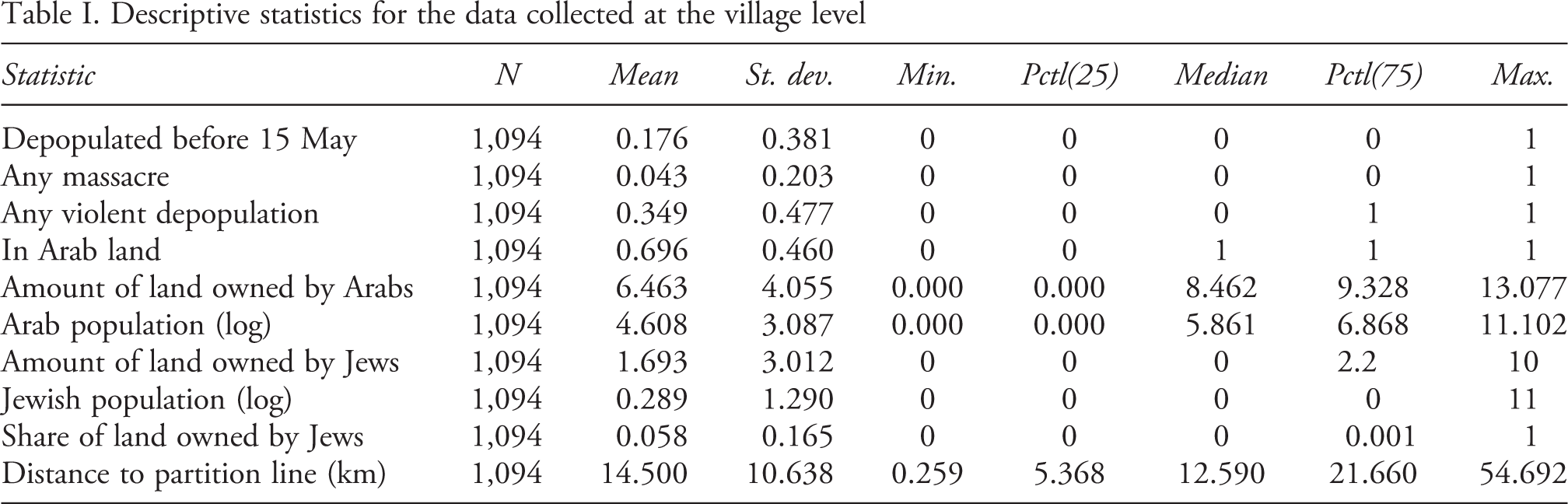
Historical data
To compile the dataset used in the analysis, I rely on a number of primary and secondary sources. The list of all villages included in the sample comes from the republished version of the 1945 survey carried out by the government of Mandate Palestine known as the Village Statistics (Hadawi, 1970). This survey includes a list of over 1,000 Palestinian villages, their population, ethnic composition, soil use, and distribution of land holdings as of 1 April 1945. The original publication was printed on a single sheet 37 inches wide. In 1970, the former Official Land Valuer and Inspector of Urban Tax Assessments from 1935 to 1948, Sami Hadawi, republished and reformatted the original government document, which was never publicly published.
For data on the villages affected by the war, I rely on the Atlas of Palestine compiled by Salman Abu Sitta (Abu-Sitta, 2004). This comprehensive list records 530 villages that were occupied or depopulated during the war. Most of the data on these villages rely on the scholarship of Benny Morris and Walid Khalidi. Morris, widely considered one of the pre-eminent scholars of the 1948 war, used Israeli archives to compile a list of all depopulated Arab villages along with the date of depopulation and a classification system that included six categories explaining why the village was depopulated. Khalidi’s data on depopulated villages is based on the Palestine Index Gazetteer’s list of villages falling inside the 1949 Armistice Line. Abu Sitta combined both lists and expanded the scope to include villages located in Beersheeba, yielding a record of 446 depopulated villages.
5
I also include a list compiled by an Israeli NGO of 26 predominately Jewish localities destroyed by Arabs, along with their date of occupation (Bronstein & Bronshtain, 2018). Importantly, the causes of the depopulation identified by both Morris and Khalidi are proximate causes. Almost no Palestinian villages were depopulated without being targeted by Israeli/Haganah
Distribution of depopulated and remaining villages that existed prior to the 1947–48 Palestine war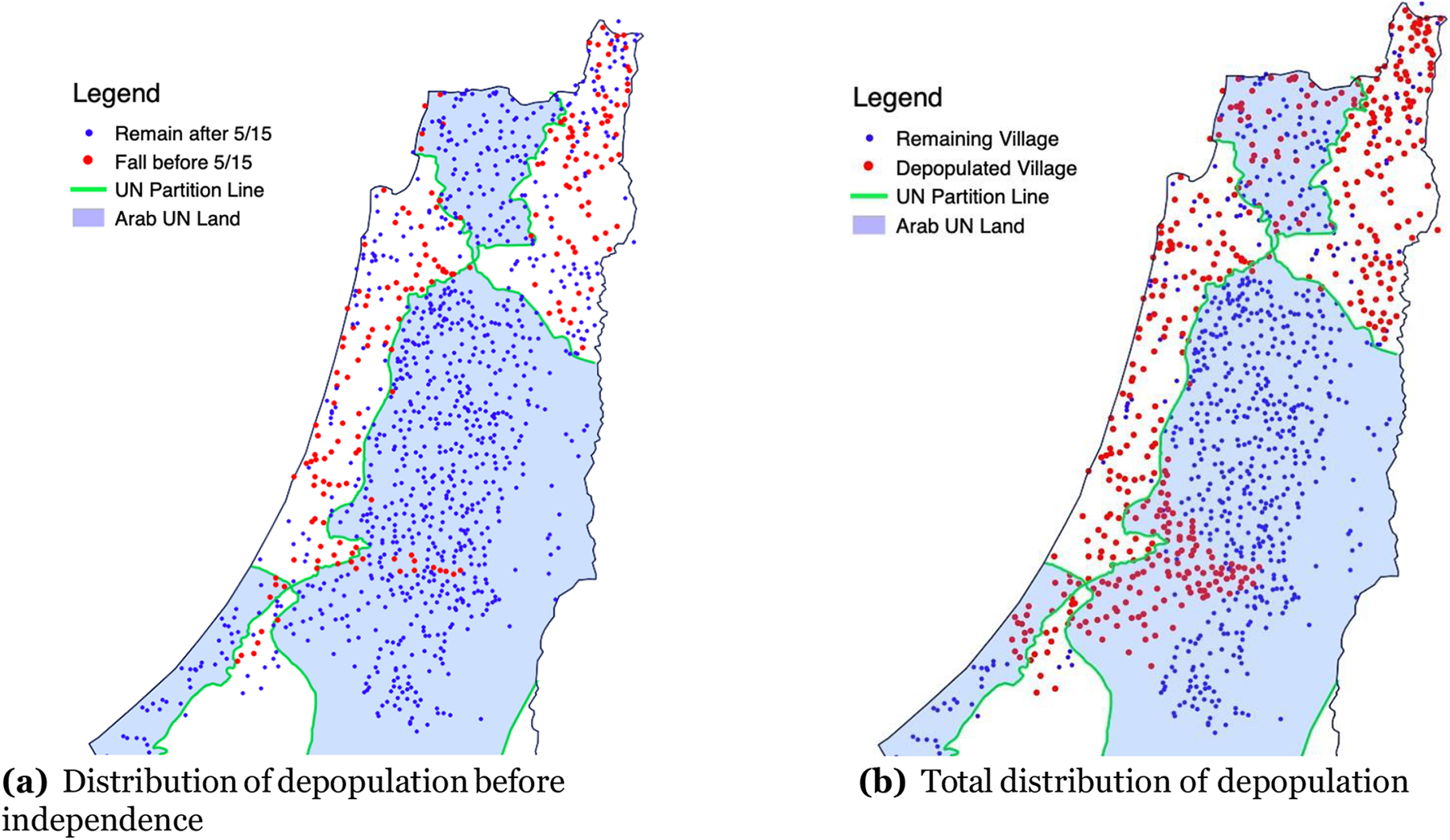
I then geocoded all of the villages located in the list of official Village Statistics using a number of contemporary and historical maps. Villages were matched by using their district and village name in either Arabic or English. GIS software was used to measure the shortest distance from each geocoded village to the 1947 UN partition border in kilometers and to identify whether the village was located in land allocated by the UN to the Israelis or Palestinians. A map showing the partition line and the Palestinian villages depopulated during the 1948 war is shown in Figure 1.
The above maps show that before 15 May, most of the depopulated villages were located within the partition line. One notable exception to this trend is the red dots in Figure 1A (which represents the villages depopulated before 15 May) surrounding Jerusalem. What explains why the Israelis violated the partition line in this area before receiving recognition? The answer is that Jerusalem was very important to the Israeli leadership, and that it was worth violating the border and attacking in that territory. David Tal writes that ‘[i]t was Ben-Gurion’s unequivocal conviction that there was no point in the establishment of the Jewish State if it did not include Jerusalem which gave this front its importance’ (Tal, 2004: 207). Before 15 May, the Haganah had clashed with the Jordanian Arab Legion around Jerusalem. The two parties had agreed to talks that would hopefully lead to a ceasefire. This, however, never occurred as the Israelis launched Operation Kilshon and attacked the areas around Jerusalem immediately upon declaring independence (Tal, 2004: 212). The result was a cluster of occupied villages around the city, as Figure 1B indicates.
The data collection results in a geocoded list of nearly all the villages that existed in Mandate Palestine before the start of the war in 1947. Summary statistics of the village level covariates are presented in Table I.
Descriptive statistics for the data collected at the village level
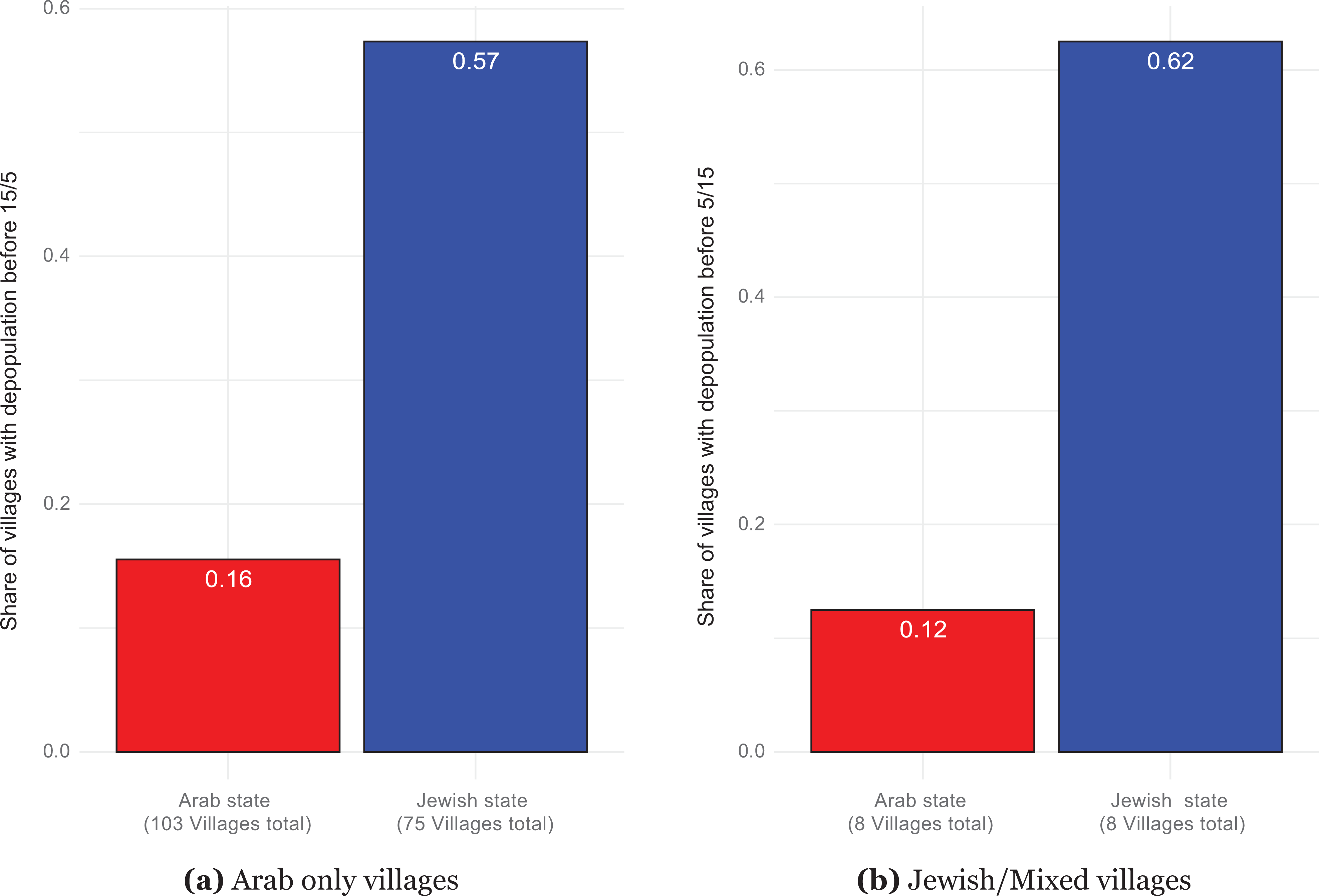
Difference in the share of villages experiencing a depopulation before Israel’s independence on 15 May
Regression discontinuity estimates
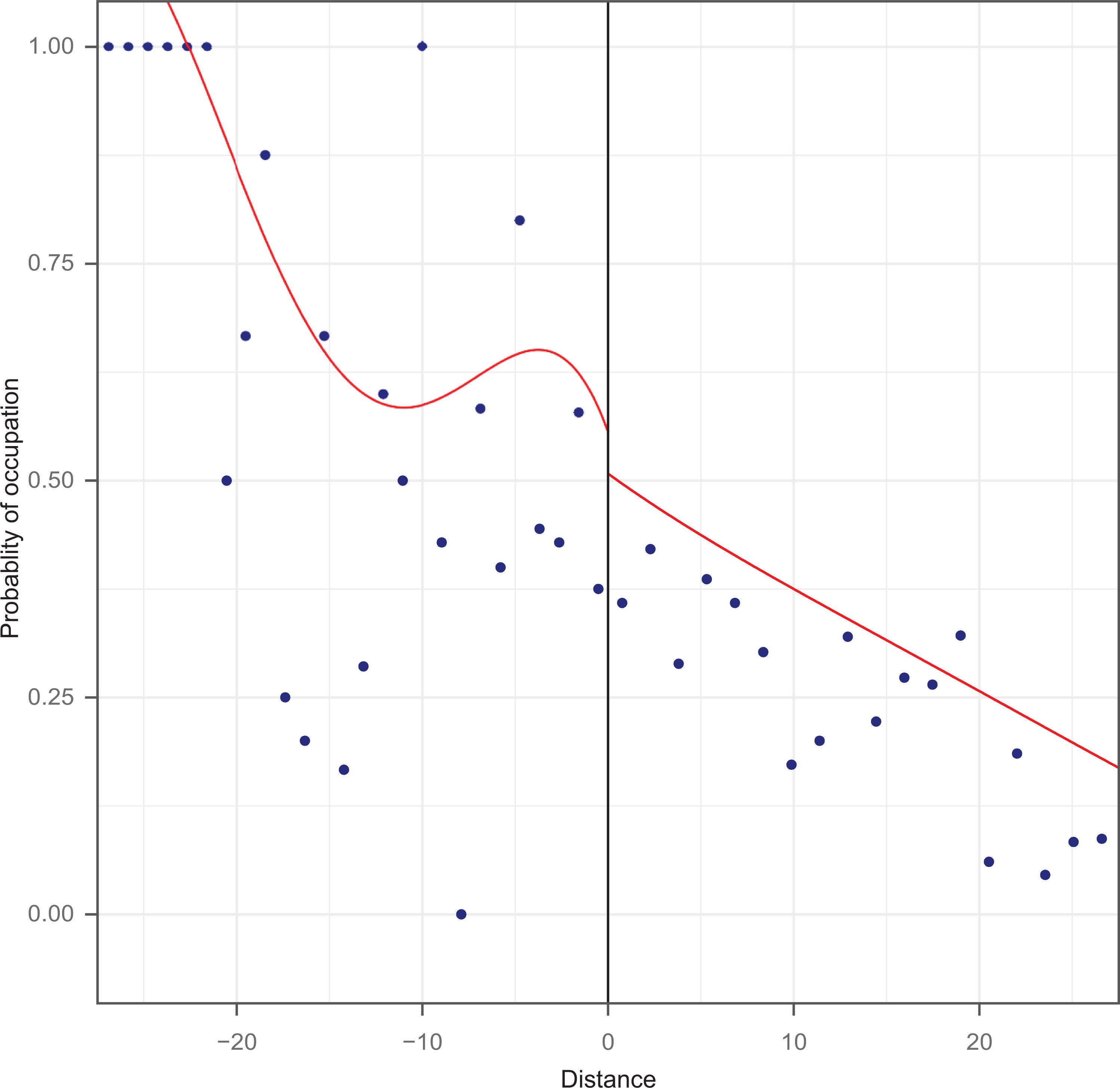
To estimate the effect of the partition border on the probability and timing of an exodus in a village, I use a regression discontinuity design with the partition border as the point of discontinuity. The estimation of the local average treatment effect (LATE) using a regression discontinuity design is performed using the data-driven approach from the rdrobust package in R (Calonico, Cattaneo & Titiunik, 2015). Here, the LATE is the estimated difference in the probability of a forcible
Effect of distance to UN border on occupation before independence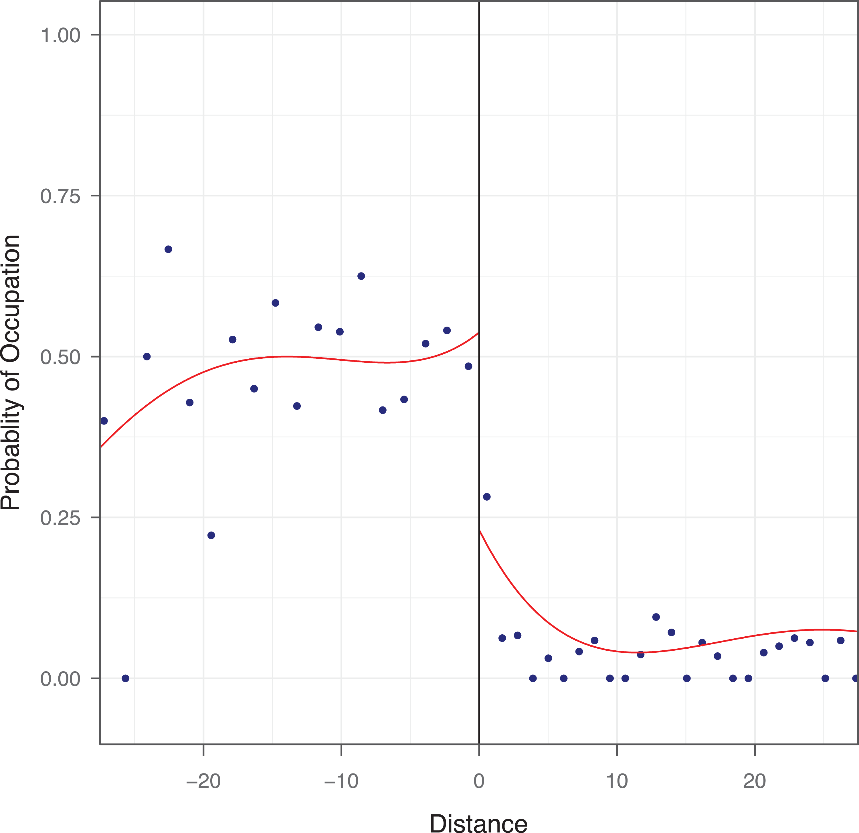
Results from graphical density tests providing evidence that there is no manipulation of the forcing variable (distance to the border) are presented in Section A in the Online appendix. This tests whether, for the villages in the dataset, the distance to the border is a smooth function, that is, that villages were very close to the border on either side. Since villages were located very close to the border, this provides further evidence that the partition line was drawn without regard of the location and characteristics of individual villages. If it was, we would expect very few villages to lie extremely close to the line, since the goal of the plan was to separate the two communities.
Effect of distance to UN border on occupation after independence
I estimate the treatment effect of the UN border on the likelihood of a village falling before the expiration of the mandate on 15 May. This design assumes that the only change that occurs at the partition line is the change in treatment status. The results for the effect of the UN border on whether a village was depopulated before 15 May is presented in Figure 3. The effects are substantial: villages close to the Jewish side of the border on average have about a 50% chance of being occupied before independence, while that probability drops to about 25% for villages on the Arab side of the border. I also test to see if there is a discontinuity at the border for villages that were occupied after 15 May. Those results are presented in Figure 4. The effect is small, slightly positive, and not statistically significant, providing evidence that the border did not constrain the Israelis after recognition was achieved.
To ensure that these results are robust to the measurement of the dependent variable, I cross-referenced Abu Sitta’s list of depopulated villages with six other data sources on the depopulated villages. 6 The estimated effects are similar and remain statistically significant if the dataset only codes a village as depopulated if it appears in at least five of the six datasets listed. The results are presented in Figure 13 in the Online appendix. I also run a number of placebo tests that test to see if there is a discontinuity for other distances. In other words, if we assume that border was drawn in a different location, is there a discontinuity in the probability of a village experiencing an exodus? The results, presented in Section J in the Online appendix, show that these placebo tests, as expected, produce null results.
Discussion
Alternative explanations
The empirical results provide strong evidence that the Israelis concentrated their efforts to build their new state within the areas allotted to them by the UN prior to receiving recognition, but then abandoned that aim once recognition was achieved. There are, of course, alternative explanations for this empirical pattern. The most plausible one is that the Israelis knew that their declaration of independence on the predetermined date of 15 May would result in an invasion by neighboring Arab states, and that the Israelis refrained from violating the border before this date because they wanted to consolidate their state by forcibly creating a homogenous population within the partition line. The war did change when the Arab states invaded. Yet there was considerable uncertainty among the Israeli leadership as to if and when the Arab states would attack (Tal, 2004: 155). Moreover, it is unclear why, exactly, respecting the partition line would increase the security of the Israelis. In keeping with the broader literature on rebel compliance (Jo, 2015), I have argued that the Israelis sacrificed their tactical security concerns by not violating the border in favor of the broader strategy of gaining international recognition. If compliance with the border did not matter at all, we would expect the Israelis to expand into areas that would increase their security without any concern about where the border lies – in other words, there would be no discontinuity. In Section M in the Online appendix, I provide a more thorough discussion of alternative explanations.
Qualitative evidence
The fact that the UN partition plan was never implemented provides us with a straightforward way to assess, qualitatively, how the plan affected the course of violence. Since the plan was not enforced, the only way that the border could affect the outcomes of interest is if the Israelis factored the location of the partition line into the decisions that they made during the course of the conflict. Here, I present qualitative evidence that this was indeed the case, and that the partition line affected the landscape of conflict while only existing on maps.
Historians of the 1948 war have debated the relative importance of Plan Dalet, which was the code name given by the Zionist High Command for the general plan for all military operations that were launched in the months preceding the expiration of the British Mandate (Khalidi, 1988; Gelber, 2001; Pappe, 2007). A key part of this plan was the forcible implementation of the UN partition plan. While Plan Dalet was designed to capture as much territory as possible, the borders of the partition plan were used to organize territorial control and the occupation of villages. For example, during one of the Israeli military operations, the Minority Affairs Ministry listed all villages that were conquered and occupied during the resistance. The author split the list of villages into two groups: those that were located inside the borders, and those that were located outside the borders (Morris, 2004b: 475).
This evidence also helps shed light on the precise mechanisms linking the UN partition plan to the course of the conflict. When the majority proposal of the plan was announced, the Jewish leadership was happy with the outcome, largely because the plan would further the goal of achieving statehood (Pappe, 2007: 36). Since the Arabs began fighting as soon as the plan was ratified, the UN was unable to implement the plan. The goal of the Haganah and the Israeli leadership was simply to do what the UN was unable or unwilling to do: to forcibly implement the majority proposal. It was only after the Israelis implemented the plan themselves that the boundaries ceased to restrain the conflict. The Israeli leadership decided that increasing territorial control presented a better method for increasing security. By the expiration of the Mandate on 15 May, the British had completely withdrawn, Palestinian society collapsed, and the Arab states were ready to attack. The first two factors removed obstacles to the Israelis’ ability to expand their territorial control, the threat from the third factor pressured them to expand their territorial reach. As Morris writes in his discussion on the Haganah’s decision to expand into either the West Bank or the Negev, while the West Bank contained East Jerusalem (‘the crucible of Judaism’), the West Bank was ‘not earmarked by the United Nations for the Jewish state; the bulk of the Negev had been’ and ‘taking the Negev would enjoy at least a measure of international legitimacy’ (Morris, 2004a: 316).
Conclusion
Scholars have argued that rebels can gain international legitimacy by complying with international law, by not using child soldiers, adhering to international treaties, and reducing violence against civilians. This article argues that respecting international borders is another way that rebels strategically signal their legitimacy.
Two levels of analyses that scholars have used to study civil conflict have been at the international level and the subnational level. Each approach has produced important insights on why rebels target civilians, why violence occurs, and the role of ethnic fragmentation on the intensity of conflict. However, there has been a gap between these two levels of analyses: scholars examining the impact of the international system on civil conflict have relied on comparisons across conflict cases or over time, while those studying subnational variation in violence have focused on the role of domestic actors on the course of conflict. Less work has been done that integrates these two levels of analysis into a ‘second image reversed’ framework. This article does exactly that by showing how the United Nations affected the distribution of violence within Mandate Palestine in 1947–48.
To support this claim I used a number of approaches to argue that the 1947 UN partition plan affected where the Israelis concentrated their state-making efforts during the 1948 war. Villages within the future Israeli state were more likely to have their Arab population expelled by the Israeli forces than villages in the future Arab state. Using a regression discontinuity design, I estimate the effect of the UN partition line on the location of an exodus and the timing of when that village was occupied. I argue that the plan affected the course of violence by granting legitimacy to the Israeli’s right to rule over the designated territory, while at the same time imposing a reputational cost on Israelis if they attacked areas outside of the partition line.
The partition of Mandate Palestine occurred in a context where the occupying power withdrew quickly and with little concern about how the ensuing conflict would play out. There are reasons why is unlikely that a similar scenario will happen again. For one, there are no more formal empires. Nonetheless my argument that rebels have an incentive to target territory in accordance with international law has important implications for understanding why rebels will refrain from violating international borders and what happens when they do. For example, rebels in Eritrea concentrated their attacks within the Eritrean state and ultimately controlled all of the territory within Eritrea’s colony borders and generally refrained from attacking areas in Ethiopia (Pegg, 2019: 60). Similar dynamics occurred in Somaliland, where rebels focused on territory within the colonial borders but refrained from attacking the mainland (Caspersen, 2013; Pegg, 2019). There are few border violations of the UN imposed partition of Cyprus (Caspersen, 2013: 38). Both ISIS and the Lords Resistance Army (LRA), which are groups that do not seek recognition and engage in a number of behaviors that violate international law, have both committed attacks in at least five separate sovereign countries (Sundberg & Melander, 2013). We do not know exactly why rebels are unlikely to violate these borders. Doing so could invite foreign intervention, it may be tactically difficult due to the presence of UN peacekeepers, or pre-existing colonial borders could simply be used to coordinate how territory is divided. What this work shows, however, is that in a case where the border is simply an imagined normative one, when rebels cared more about international compliance they limited their border violations. Future research can examine how and when the international community sanctions rebels for border violations.
The 1948 war in Mandate Palestine is an excellent case to test my theory because the partition line was purely imaginary. New borders are rare, and less likely to play a role in contemporary contexts than they did in the decolonization era. However, we should expect the precise mechanisms to bring about similar results in other conflicts. Secessionist rebel groups achieve statehood in part by receiving international recognition. Revolutionary rebels can also respect international law as a way to cultivate international support among key constituents. Rebels can signal to the international community that they respect norms by refraining from using chemical weapons or excessive violence against civilians. The findings presented in this article show that the pressures to respect international law can also affect the spatial distribution of violence, and not just the total violence within a conflict.
Footnotes
Replication data
Acknowledgements
Thanks to Allison Carnegie, Sarah Daly, Page Fortna, Jack Snyder, David Carter, Megan Stewart, Alex Chang, Mike Rubin, Daniel Arnon, Beth Simmons, Mike Kenwick, the attendees of the 2018 Borders Boundaries Conference and the 2019 Peace Science Society Conference.