
Abstract
This article presents a history of Druid Park Lake Drive, a multilane road in Baltimore, Maryland that acts as a barrier between Baltimore's Druid Hill Park and the African American neighbourhoods to its south. Lake Drive is often understood by residents and journalists as a racially discriminatory infrastructure, consciously designed to engender segregation. By analysing newspaper articles, interviews with residents and old maps, this article finds that Lake Drive was never intentionally planned to carry out a politics of exclusion. Its racial politics, instead, emerged over time as broader demographic, environmental, cultural and political developments took place in the corridor that surrounds Lake Drive. This argument calls into question the practice of focusing solely on planners’ intentions when analysing the politics of infrastructure. Instead, we should ask what broader factors imbue roads with politics – and how these politics change over time as these roads are encountered and used by different people.
Introduction
To many current residents of Baltimore, Maryland, Druid Park Lake Drive – the busy street south of the city's major park, Druid Hill Park – symbolises the racial inequality embedded in the city's transportation infrastructure. The multilane road acts as a barrier between the park and the predominantly African American neighbourhoods to its south – Reservoir Hill, Auchentoroly Terrace and Mondawmin. The road, constructed in the 1960s, makes it difficult for residents, many of whom have a low income and do not own a car, to access the park. As a recent Baltimore Sun commentator notes, Lake Drive has turned the park into a “destination for outsiders” rather than a neighbourhood park. 1 In 2021, Baltimore City officials publicly acknowledged that the road functioned as a barrier, and had begun gathering neighbourhood residents’ input on how to remake the corridor in a more accessible fashion. 2 As of writing, however, no accessibility improvements have been realised, and construction around nearby Druid Lake has arguably made the cleavage between the park and the neighbourhood worse.
Mapped onto the landscape of the Druid Hill Park-Reservoir Hill corridor are thus sharp economic and racial discrepancies. What historical forces conjoined to produce a powerful physical barrier – a road – that both symbolises and reinforces these discrepancies? Recent press coverage in the Baltimore Sun suggests that these discrepancies were the direct result of conscious planning choices and appeared almost immediately when the road was constructed: “before the 1940s, the park and its surrounding neighbourhoods […] used to meet organically…then came decisions by city leaders in the 1940s and 1960s that isolated Druid Hill Park”. 3 This article demonstrates, in contrast, that the racial politics now enacted by and associated with Lake Drive were not part of the original design of the road, but instead emerged over the decades that ensued the road's construction, as the neighbourhoods surrounding the road changed.
The Sun's suggestions above echoes a mode of analysis that sociologist Bernward Joerges has termed the “design-version of ‘artefacts-have-politics’”: the notion that designers, upon creating a technological artefact, may “transfer” political values into that artefact, and that those politics are then exerted by that artefact on its surrounding in a relatively stable fashion over time. 4 The design-version argument can be traced back to Langdon Winner's landmark 1980 essay “Do Artefacts Have Politics?”. That article famously contained the example, borrowed from Robert Caro's The Power Broker, of Robert Moses designing low-hanging road overpasses to prevent buses – and thus low-income and African American transit users – from accessing Long Island's Jones Beach. 5 Historians have since contested the empirical accuracy of this example. 6 Nonetheless, it has had an unmistakable impact on the ways scholars, journalists and policymakers conceptualise the politics of roads; Secretary of Transportation Pete Buttigieg even referred to Moses’ overpasses while discussing the legacy of mid-century highway construction programs in a November 2021 White House press conference. 7
The design-version argument was further explored by historians of technology who, in the 1990s, began to reject scholars’ traditional focus on the early innovation stages of technologies in favour of examining their complete life cycles. 8 Svante Lindqvist, in particular, articulated the design-version argument, arguing that the politics and values embedded in a technology upon its creation shape society in later phases of that technology's use. Lindqvist claimed in 1994 that “our technological landscape is dominated by the large-scale technological systems that were shaped in the past” and that “this means that only a minority of the technology we employ today is a reflection of our present values and social structures”. 9 Lindqvist cites automobilism as an example of an enduring technological system reflecting early-twentieth-century values (e.g., the importance of individualism, the notion that natural resources are inexhaustible) that, as it has endured, continues to impose those values on us. Christopher Wells presents an empirical case for a similar understanding of American automotive history in Car Country (2013). 10
Is Lake Drive a similar example, albeit on a smaller scale? Is it a vehicle through which decision-makers of the mid-twentieth century continue to impose their politics on Baltimore residents? By examining the whole life cycle of Lake Drive, this article demonstrates that the design-version of “artefacts as politics” cannot adequately capture the complexity and fluidity of the politics that the road has exerted on the surrounding corridor since its construction. Roads like Lake Drive, I show, do exert politics, and sometimes those result directly from design choices. However, these politics are not necessarily stable; they can evolve over time as they are reshaped by external cultural, environmental and political factors. Although historians of technology have found examples of other technologies where the designers’ intended politics and the actual politics of the technology-in-use diverge, the literature at the intersection of race and urban roads and freeways remains heavily focused on infrastructural injustices resulting directly from planning decisions made in the mid-twentieth century (and indeed, we have countless, important examples of mid-century highway planners disregarding concerns over the displacement of communities of colour, and even intentionally using road construction as a means to further racial segregation). 11 By providing an additional way of thinking about the politics of roads as they evolve once construction is completed, then, this article expands our understanding of the nexus between infrastructure, racial politics and temporality.
Concretely, I demonstrate in this paper that the racialised politics now enacted by and associated with Lake Drive were not inherent in the design of the road when it was constructed in the 1960s. Instead, these politics have emerged over time as the product of a wider, entangled history of racial politics and cultural, economic, environmental and technological developments. This paper, then, reconstructs those intersecting developments, many of which have structural roots that precede the construction of the road itself. With a synthesis of insights from existing literature and with an analysis of newspaper articles, oral histories, maps, cultural artefacts and government documents, this article focuses specifically on the corridor comprising Druid Hill Park and Reservoir Hill, a neighbourhood south of the park and west of the Jones Falls Expressway. I will reconstruct, first, the development of the park and its surrounding neighbourhoods in the late-nineteenth and early-twentieth century; second, the demographic and racial dynamics in the park-neighbourhood corridor before the 1960s; third, the construction of Lake Drive as a multilane road in the 1960s; and fourth, developments in the park-neighbourhood corridor since the urban crisis period that began in the 1960s. I end by showing how different aspects from this history have converged to transform Lake Drive into the, in the words of one local resident, “completely inequitable” road that it is today (Figure 1). 12
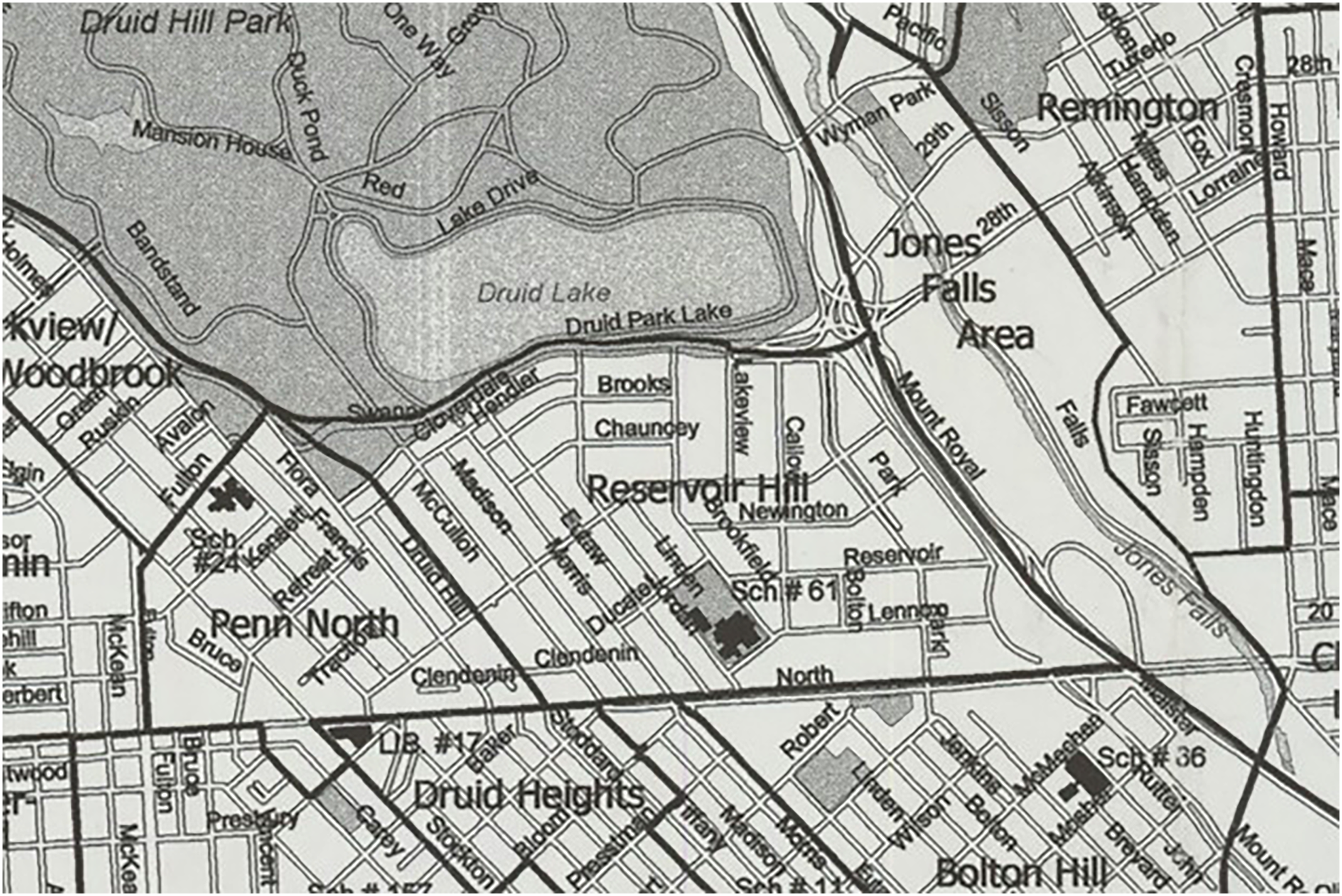
The Druid Hill Park-Reservoir Hill corridor, 2003.
Constructing the corridor
For several years, my daily bicycle commute involved crossing Lake Drive. I soon became interested in this road – both in how it enacted its politics of exclusion, and in the symbolic meanings residents attached to it. Traveling through Reservoir Hill and Druid Hill Park, one encounters scenes that are not always easy to “read”; to render legible by connecting them to specific spatial, cultural and historical contexts. 13 For instance, following Eutaw Place into the Reservoir Hill neighbourhood, one is confronted with a large vacant lot on North Avenue. This is the former site of the Madison Park North Apartments, a once notorious low-income housing development. 14 Further north on Eutaw Place, one sees imposing turn-of-the-century brownstones, some of which have undergone recent renovation, others of which are neglected or vacant. Nestled between these row homes and the litter-filled alleyways is the Beth Am synagogue, a surprising feature to the casual observer, given Reservoir Hill's predominantly non-Jewish, African American population.
Lake Drive itself is a poorly maintained, multilane road that feeds a high volume of traffic onto the nearby Jones Falls Expressway. Some of the homes that face the road are abandoned and surrounded by litter and weeds. Between Madison Ave and I-83, only one traffic light allows pedestrians and bicyclists to safely cross and enter the park – and in recent years, a construction zone has blocked this crossing, forcing pedestrians to jaywalk if they want to avoid a large detour. In contrast to Lake Drive, Druid Hill Park itself appears to be well-maintained; it is green, mostly clean and offers modern recreational facilities such as a public pool and tennis courts.
The discrepancies in this neighbourhood-park corridor have deep historical roots, as their emergence built upon a much longer history of Native American displacement, slavery and ethnic and racial segregation. Before the arrival of Europeans in the mid-Atlantic region, the Susquehannock people inhabited the land that now comprises Druid Hill Park and Reservoir Hill. They lived in large settlements where they grew crops and developed complex political systems. 15 They may have settled the site of Druid Hill Park because of the water sources it afforded, including the nearby Jones Falls stream. 16 The proprietary English colony of Maryland was founded in 1632, when King Charles I granted the territory to George Calvert, 1st Baron Baltimore. A century before the city of Baltimore was founded, early settlers mostly lived spread out along the Chesapeake Bay tidewater, where, using slave labour, they grew tobacco that they traded with British merchant ships. 17
The Susquehannock ceded land that included what now comprises Druid Hill Park to the colony in 1652. Between 1652 and 1716, the land, now used primarily for lumber, changed hands several times. In 1716, merchant Nicholas Rogers purchased part of the land. After his death in 1720, his daughter Eleanor inherited this property. A few years later, Eleanor married George Buchanan, one of the first Baltimore city land commissioners. In 1741, the Buchanans purchased the remainder of the land that is now Druid Hill Park. They turned their parcel into a plantation named Auchentorlie, forcing enslaved people to cultivate corn, tobacco and potatoes on the land. 18
Baltimore was founded in 1729 but its initial growth was slow; in 1752, the town had only about 200 residents. Between 1750 and 1770, Baltimore's growth accelerated to about 5,000 residents, and it would continue to grow steadily in the decades afterwards. In the nineteenth century, Baltimore expanded and industrialised rapidly; by 1860, Baltimore had become a large city of approximately 212,500 residents. That year, Baltimore City purchased the Auchentorlie estate – then owned by Lloyd Nicholas Rogers, a distant heir of the Buchanans – to create the city's first park, which opened later that year. The purchase was initiated by a commission appointed by then-mayor Thomas Swann. After an extensive search, this commission had selected Auchentorlie based on its location, price and its existing “park-like appearance”. The city completed the Druid Lake reservoir later, in 1871, and the Baltimore City Zoo opened in the park in 1876. 19 Like Central Park in New York City (1858) and Golden Gate Park in San Francisco (1870), Druid Hill was conceived as a “great pleasure ground”, meant to mimic the serene characteristics of the countryside so that urbanites could escape the pollution and crowdedness of industrialising cities. 20
The neighbourhood now known as Reservoir Hill was originally part of the Mount Royal District, named after the Mount Royal mansion, which a Baltimore physician had built as a summer home in the 1750s on what would become the intersection of Park Avenue and Reservoir Street. The Mount Royal district also included what is now known as the Bolton Hill neighbourhood. The city rechristened the upper half of Mount Royal as Reservoir Hill in the early 1970s to distinguish it from the more affluent Bolton Hill. Residents remember the Mount Royal neighbourhood to have comprised a cohesive whole prior to the urban changes of the 1960s and 1970s. 21
By 1869, there had been some residential development in what is now Bolton Hill, but only farmland, forest, a mansion and the Mount Royal water reservoir above North Avenue in Reservoir Hill. 22 Reservoir Hill had been parcelled out by 1890, and residential development there occurred gradually in the first decades of the twentieth century; most of that emerging street pattern still exists today. 23 Mount Royal was attractive for developers primarily because of its high ground, which afforded views of downtown (Figure 2). 24

Painted map of Baltimore, 1869.
The early twentieth century saw the construction of a network of streetcars in the neighbourhood. By the early 1940s, the Reservoir Hill area would have streetcars running on Madison Avenue, Whitelock Street, Linden Avenue and North Avenue. The Madison Avenue streetcar, Route 16, had its terminus at the monumental archway entrance to the park near the intersection with Cloverdale Street. The archway entrance, built in 1868 as an entrance to the park, still stands today but, in the mid-twentieth century, was cut off from the park by the construction of Lake Drive. 25
People in the corridor
In the second half of the nineteenth century, Mount Royal's primary residents were white Christian notables, including Johns Hopkins University president Daniel Coit Gilman and future president Woodrow Wilson. From the 1880s onwards, upper-class German Jewish merchants and industrialists began moving in, prompting a first episode of “white flight”; as Jewish elites moved in, white elites moved out. As developers constructed the Reservoir Hill section of Mount Royal, the new area attracted mostly Orthodox Jewish immigrants from Eastern Europe. Relations between the German and Eastern European communities in Mount Royal were “often tortured”, historians Eric Goldstein and Deborah Weiner write. 26 By the 1920s, German and other Central European Jewish elites lived mostly along Eutaw Place; upper-class Eastern European Jews lived mostly in northern Reservoir Hill near the park; and working-class Eastern European Jews lived mostly along North Avenue. 27
The concentration of Jewish communities in Mount Royal, which itself featured micro-segregation according to class, denomination and ethnic origin, reflected a city that was rigidly partitioned into distinctive racial and ethnic enclaves. The 1937 Homeowner's Loan Corporation “redlining” map of Baltimore clearly demarcates Jewish Mount Royal, rated “third grade”, from the black neighbourhoods in West Baltimore, rated “fourth grade”. 28 Segregation extended into the park, where facilities such as swimming pools and tennis courts were racially segregated until the 1950s. 29 Before the 1950s, most American cities, including Baltimore, had a dual housing market – one for whites and one for African Americans. Jewish people also faced significant housing discrimination. A “silent conspiracy” between local government and the real estate sector ensured the survival of the dual housing market, even after the Supreme Court overturned racial zoning ordinances (in 1917) and racially restrictive housing covenants (in 1948). 30
Before the 1950s, redlining and similar discriminatory housing practices led to overcrowding and neglect in African American neighbourhoods, as residents had nowhere else to move to and landlords, assured of their tenant base, had little economic incentive to invest in maintenance. After the urban housing market opened up more widely to African Americans in the 1950s – often through nefarious “blockbusting” practices where real estate agents manipulated white anxiety over their home values for their own monetary gain – many African Americans moved out of previously redlined neighbourhoods. 31 Throughout this cycle of flight, which would soon spread to Jewish and white neighbourhoods including Reservoir Hill, decay in the physical urban environment was shaping the social realm; in tandem with racial and economic anxieties, scenes of vacancies neglect and lowered property values and induced emigration patterns.
Before the 1950s, the park was segregated, but it still forged occasional encounters between racial groups that otherwise functioned in separate spheres. For instance, when African American residents of the neighbourhoods west of the Reservoir Hill area wanted to visit the park, they had to walk through streets lined with Jewish shops. Harry Peaker, an African American man who grew up in Madison Park and had later moved into Reservoir Hill as the area underwent a broader racial shift in the 1950s, remembered: During my youth we had segregated facilities; your swimming pool, your own tennis court, your own areas of the park where the two races frequented. […] I remember as a kid I could come go to Druid Hill Park, either up Eutaw to the park or either up Madison to the park. […] Whitelock Street was a Jewish merchant center. They had kosher butchers, kosher grocery stores, they had tailor shops.
32
Barry Levinson's 1990 film Avalon helps understand the Jewish experience in the corridor prior to and during the racial transition of the 1950s and 1960s. 33 The film revolves around Sam Krichinsky, a Jewish immigrant from Eastern Europe who had arrived in America in 1914 and narrates the American experience of the Krichinsky family over multiple generations. Set in Levinson's native Baltimore, the film is semi-autobiographical. Avalon provides important insights into the evolution of American Jewish society, imparting, in the words of Eric A. Goldman, “a superb portrait of the American Jewish immigrant experience in the early part of the twentieth century, from the arrival of Jews in America to their adaptation to the American way of life and their struggle to claim a slice of the American pie”. 34
Avalon interweaves its story of changing Jewish identities with a story of changing places, capturing a specific moment in American urban history: the point leading up an urban crisis as Jewish and white residents left the central city. A scene set in Druid Hill Park in the 1950s is particularly telling in this regard. Sam and his grandchildren go to the park to spend the night sleeping outside to escape the summer heat in their neighbourhood. The scene suggests that this was a frequent practice before the widespread availability of air conditioning, as several other families are also spending the night in the park. A 1979 op-ed by Milton E. Stanley, who was African American and grew up frequenting Druid Hill Park, confirms this: “on extremely hot nights, it used to be completely safe to take a blanket to Druid Hill Park and sleep under the stars”. 35 To Baltimoreans viewing the film upon its release in 1990, this must have seemed out of place, because at that time the park and the surrounding neighbourhoods had a reputation for being unsafe (discussed in more detail below). Indeed, the sole reference to Druid Hill Park in The Wire, the acclaimed series from the early 2000s that detailed the intricacies of the Baltimore's urban crisis, is to a human body having been dumped there “behind the Reptile House”. 36
The Druid Hill Park scene in Avalon ends with all characters sleeping, except Sam, who is still up pondering memories of his past. Sam's nostalgic introspections, combined with the fact that they drove to the park despite living in the neighbouring Mount Royal neighbourhood – the Avalon house is on Wilson St. in Bolton Hill – imparts the scene with a simultaneous sense of serenity and impending doom. 37 Other scenes in the movie reinforce this sense. There is, for instance, a literal collusion between a picturesque streetcar, symbolising traditional urban transportation patterns, and a car, symbolising the new, suburban lifestyle. 38 With the advent of new technologies such as cars, buses, air conditioning and mass-produced housing, the city, and the way it facilitates Jewish life within it, is about to change.
Constructing Lake Drive
As Baltimore was suburbanising and more residents purchased automobiles, the Baltimore Transit Company gradually dismantled Reservoir Hill's streetcar system in the early postwar years. By 1950, most lines had been replaced with buses; only the North Avenue streetcar remained. 39 The dismantling of Reservoir Hill's streetcar system coincided with the construction of major roads for cars, most notably I-83 (the Jones Falls Expressway, constructed in the late 1950s) and its multilane feeder road that follows Lake Drive and Auchentoroly Terrace.
The City built the feeder road on the site of a previous, much narrower road also known as Lake Drive, which was designed as part of Druid Hill Park and had existed at least since 1873. 40 That road had accommodated horse carriage rides through the park – although, as one observer noted in the Baltimore Sun, by 1919 the road had been mostly overtaken by “horseless carriages” (i.e., automobiles). 41 In 1958, City leaders unveiled plans to widen this road into a six-lane highway that would guide traffic to and from I-83. Widening the road required the demolition of a “tree-shaden park strip” on the Reservoir Hill side of the road. 42 In the early 1960s, this plan met significant citizen opposition from residents. In May 1963, a group of residents led by Nathan Z. Goldberg and Sidney Sakols formed the Lake Drive Improvement Association, aiming to retain the “beauty, character and charm of Lake Drive”. 43 The Association's organising strategies included visits with City Council members, publishing letters in newspapers and even nonviolent direct action (camping out on construction zones). 44
Park accessibility was not among the Improvement Association's organising issues. Rather, the Association – comprising mainly or entirely of Jewish and white residents – framed the road as a threat to the stability of their neighbourhood – a racialised argument that must be understood in the context of a city – and a nation – in which many neighbourhoods were experiencing white flight and racial change. 45 In 1959, Reservoir Hill was still predominantly Jewish (recorded as “white” in a 1960 urban renewal study, see Figure 2). 46 Jewish Reservoir Hill residents saw the road as a threat not because it would restrict African American (or Jewish) residents’ access to the park, but because it might attract lower-income Black residents to their neighbourhood by diminishing property values. One Lake Drive resident wrote in a Baltimore op-ed that the “occupants [of houses in the Lake Drive area] are people in the middle-income bracket – precisely among the sort of people the city wants to keep”, adding that “if the city wants to contribute its bit towards driving middle income families out and converting the neighbourhoods they used to inhabit into slums, then, indeed, let it go ahead with its Lake Drive dualisation project” (Figure 3). 47
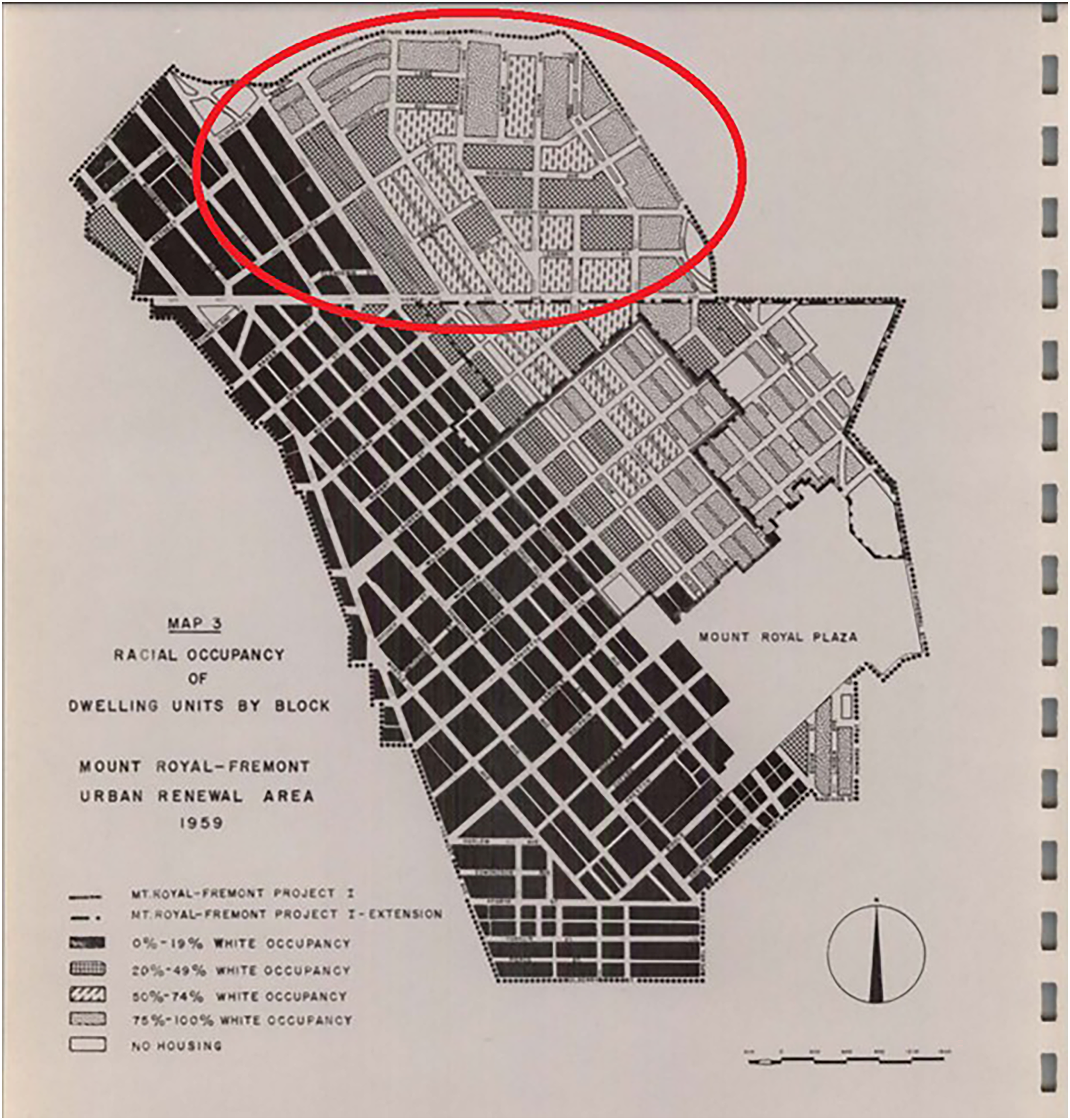
Occupancy of residential units by race in Mount Royal, 1959; Reservoir Hill is encircled. According to this study, the two sub-areas that comprised Reservoir Hill were respectively 60.3% and 48.7% white (including Jewish).
The planning of Lake Drive coincided with Baltimore's Mount Royal-Fremont Urban Renewal initiative, which the City Council authorised in 1957 and which targeted both present-day Reservoir Hill and present-day Bolton Hill. The project included plans to rehabilitate dilapidated housing, but also plans for large-scale clearance and redevelopment. By 1966, several plots of land, once occupied by housing considered substandard, had been cleared and construction of new homes that targeted higher-income occupancy was underway in the neighbourhood; today, the area has several blocks of post-war construction (e.g., on the 200 block of McMechen) that originated in the urban renewal initiative. 48
The thinly veiled aim of this initiative was to ensure that Mount Royal would retain a significant population of affluent whites: “attracting upper middle-income and upper-income white families back to this near-downtown section of the city will […] assist in the needed balancing of the housing supply and population distribution and contribute to the city's shrinking tax base”, one consultant on the project wrote in 1961. 49 When planning Lake Drive, city leaders thus would have understood Reservoir Hill as a current and future white area – not a low-income African American area where residents would have little political leverage to contest a road project.
Members of the Improvement Association eventually negotiated a modest compromise with City Council members; in February 1964, the Council passed a resolution to reconstruct Lake Drive as a five-lane (rather than six-lane) road. Several Improvement Association members, however, disagreed with the compromise and organised a second neighbourhood group, the Emergency Committee for the Preservation of Lake Drive, in May 1964. 50 Despite this group's sustained opposition, by November 1964, construction of the five-lane road was underway; by 1965, the new design was completed. Reservoir Hill now bordered a multi-lane road instead of a park strip. 51
Crisis in the city and the park
Today, Lake Drive enacts exclusionary politics because it cuts residents of several majority African American neighbourhoods, including Reservoir Hill, off from nearby Druid Hill Park. Upon the road's construction, however, Reservoir Hill was still a majority Jewish area, and the issue of easy park access did not play a significant role in public discourse about the road. Moreover, the construction of Lake Drive encapsulated the broader urban renewal approach that Baltimore adopted in Mount Royal – an approach meant to retain and attract middle- and upper-income white residents in the area.
Rather than originally intended as a racial barrier, Lake Drive's exclusionary politics co-emerged in the years after the road's construction with several other, interrelated developments that took place in the corridor – many of which had structural roots in the much longer history of racism and segregation in Baltimore. These developments included racial change, unrelenting poverty in some African American communities, urban policy choices in the realms of housing and urban renewal, urban decay, and intensified calls for racial justice after the killing of Freddie Gray in Baltimore in 2015. Taken together, these developments helped transform both the political function and the meaning of Lake Drive into what it is today.
As in many inner-city neighbourhoods in Baltimore and other American cities, Reservoir Hill underwent a massive demographic transformation in the postwar decades facilitated by the construction of new suburbs, car infrastructure and new racial discrepancies in patterns of social mobility. 52 The area went from 88 per cent Jewish in 1950 to 88 per cent African American in 1970. By 1970, Reservoir Hill had become a neighbourhood of renters; only 8 per cent of households were homeowners. 53 Residents remember most of the racial change taking place after 1959 – during and after the construction of Lake Drive. 54
Racial change in Reservoir Hill occurred in the context of a developing “urban crisis”; as affluent whites fled to the suburbs, they diminished the city's tax base – complicating the maintenance of public spaces – and left many houses vacant. Poor residents of colour made up an increasingly larger proportion of the city's shrinking population. 55 Factory closings due to increased global competition as new international markets opened up, combined with the weakening of labour organisations from the 1970s onwards, made remaining city residents more economically vulnerable. Between 1980 and 1990, the population of Baltimore living in poverty would expand by 25,000, and as of 2016 almost a third of African Americans in Baltimore live below the poverty line. 56 By 1983, after decades of slow decline, the Baltimore Sun described portions of Reservoir Hill as “rotting, frequently vandalised and rat-infested”, while also noting that Madison Avenue and Eutaw Place, the blocks with the most imposing nineteenth-century brownstone row homes, were experiencing some gentrification as white historical preservationists had moved in. 57
In April 1968, after the assassination of Dr. Martin Luther King, Jr., civil disturbances broke out all over the city of Baltimore. In response, Maryland Governor Spiro Agnew requested President Lyndon B. Johnson to send Federal troops into the city to quell the unrest. Many of these troops, about 4500 soldiers, camped at Druid Hill Park during their five-day stay in the city. 58 On 7 April and 8 April 1968, rioting broke out in the Reservoir Hill neighbourhood. Looting and arson occurred primarily on the 900 block of Whitelock Street, a business district then still dominated by Jewish merchants. Two food stores and a liquor store were set on fire. National Guardsmen arrived shortly after to protect the firefighters on the scene. The riots are sometimes understood as the chief cause of Baltimore's urban crisis, but in fact the urban crisis was already well underway beforehand. The riots reflected rather than caused the crisis. 59 Nonetheless, the destruction of the stores in Reservoir Hill had a lasting impact on the neighbourhood; after the uprising, most remaining Jewish merchants left. 60 Physical decay and abandoned storefronts then started acting as a vicious cycle, reinforced by racialised discourse. By 1975, the Baltimore Sun described the 900 block as “a ghetto commercial throughfare in Reservoir Hill frequented by winoes and junkies”. 61
In 1979, Reservoir Hill's first and only public housing project was completed, the Lakeview Towers for the elderly, on Lake Drive. 62 By that time, however, it was already becoming clear that high-rise public housing projects were not addressing urban problems and contributed to what historians call the “second ghetto”: racially segregated housing patterns that were largely the product of federal interventions. 63 Since the 1980s, housing policy has increasingly focused on “Section 8” voucher programs that allow low-income people to rent from private property owners. 64 The Reservoir Hill neighbourhood features several large apartment buildings that are primarily marketed to “Section 8” renters, including the historic Esplanade building and the aforementioned Madison Park North apartments. 65 The latter, known in the press as the “Murder Mall”, continues to impact the neighbourhood after its 2015 demolition; as, of 2023, its former site is a large, overgrown vacant lot that deeply marks the entire Reservoir Hill section of North Avenue. 66
Druid Hill Park, too, entered a period of decline in the 1970s and 1980s; contemporary newspaper articles complain of crime and decay caused by litter and people parking on park lawns. A 1974 article in the Baltimore Sun claimed that “other city parks show varying patterns, although all have substantially fewer crimes than Druid Hill”, indicating how notorious the park had become. Other Sun articles from this period focused on environmental problems in the park. For instance, a 1978 article noted that “parts of the grounds are already dead because the soil has been compacted and deprived of nutrients by the constant parking of cars” and a 1982 article claimed that “with cars parked all over the grass, the park often resembles a parking lot which certainly does not seem inviting to potential zoo visitors”. 67
The path to a political road
In some areas of Baltimore City, the social effects of urban crisis – poverty, unemployment, high crime and incarceration rates, and health disparities – have become less pronounced over recent decades. However, Reservoir Hill, which, according to the Baltimore Neighborhood Indicators Alliance at the University of Baltimore is today approximately 83.3 per cent African American, continues to deal with many of these issues. The median household income in Reservoir Hill is $35.965, compared to $54.215 in Baltimore citywide (and $132.675 in South Baltimore, a predominantly (85.7 per cent) white area). In Reservoir Hill, 10.6 per cent of family households, and 24.1 per cent of children live below the poverty line. The violent crime rate is approximately 36 per cent higher than the citywide average. 68
Issues of access and mobility also reflect the lingering effects of the urban crisis. Whereas only 16.1% of Baltimoreans use public transport to get to work, 28.7 per cent of Reservoir Hill residents take the bus, metro or light rail to their place of employment. Similarly, 37.8 per cent of Reservoir Hill homes have no vehicles available, compared to 27.0 per cent citywide. These figures contrast sharply with those of South Baltimore – where only 3.1 per cent of residents use public transportation and only 3.4 per cent do not have access to a car – illustrating the racial discrepancies that characterise transportation in Baltimore. 69 In 2015, when the Average Healthy Food Availability Index was last calculated for Baltimore, Reservoir Hill scored lower (at 7.7 out of 28.5) than the city as a whole (9.4); the 2015 report identified Reservoir Hill as a “food desert”, and indeed, there is no grocery store in the neighbourhood. 70 The intersection of access and mobility issues and race that characterise the neighbourhoods surrounding Druid Hill Park were not present to the same degree when the road was constructed, but over time they helped worsen the road's exclusionary politics; the road becomes more of an obstacle to the (disproportionately Black) residents who cannot use it – for instance, to get to the park – and who face marginal access to food and work throughout their daily lives (Table 1).
2021 Indicators for Penn North-Reservoir Hill, Baltimore City and South Baltimore
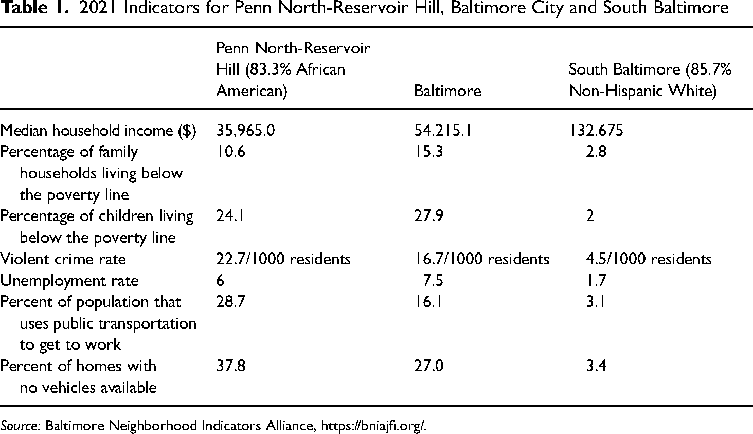
Source: Baltimore Neighborhood Indicators Alliance, https://bniajfi.org/.
The evolving cultural and political context has also further cemented and spread understandings of Lake Drive as political infrastructure. “The street is designed like an expressway, but this is a historically Black residential neighbourhood, working class…It is completely inequitable”, said Graham Coreil-Allen, a local resident, in 2021. 71 Such sentiments have grown along with a broader demand for racial justice in recent years. After the police killing of Freddie Gray in 2015, who lived not far from Reservoir Hill in Baltimore's Sandtown-Winchester neighbourhood, the city erupted in civic protests that brought international attention to Baltimore's long history of racial injustice. 72 As social movements such as Black Lives Matter have grown, both local journalists (e.g., at the Baltimore Sun) and Baltimore residents have broadened their understanding of the nature of racial injustice to include matters pertaining to transportation infrastructure. In particular, two local examples of infrastructural violence have played a prominent role in local discourse in recent years: first, Baltimore's “highway to nowhere”, which was routed through an historically Black neighbourhood in West Baltimore, never to be connected to the larger Interstate Highway System; and second, Governor Larry Hogan's decision, in 2015, to cancel plans for the Red Line light rail and divert funding for this project (that would have connected Black neighbourhoods with jobs and retail downtown) to suburban roads. 73 The racial and socioeconomic dynamics of mobility and access have also become much more scrutinised. In recent years, local activists have approached Baltimore's lacklustre public transit system as a civil rights issue, arguing, for instance, that the cancellation of the Red Line violates the Civil Rights Act of 1964; other activists have organised to improve food access in Baltimore's Black neighbourhoods by establishing Black-owned and -operated urban farms. 74
Conclusion
Throughout its history, the Druid Hill Park-Reservoir Hill corridor was shaped by the people that resided in the neighbourhood, used the park and constructed cultural understandings of the corridor; by policy choices at the local, regional and federal levels; and environmental and technological artifacts. Working concomitantly, these aspects infused the corridor – and Druid Lake Drive, in particular – with evolving racialised politics. Never intentionally planned to carry out exclusionary politics, Lake Drive began to function – and to be understood – as one, as the park and neighbourhood began to exhibit signs of decline, and as local public discourse has become more attentive to issues of racial injustice. As Baltimore City officials and residents imagine a better future for the corridor, interrogating the broader context in which infrastructure becomes political is critical. Redesigning Lake Drive, as the city is currently planning, would surely have a positive impact, but it will not solve the more general issues of access to jobs, food, cars or efficient transit, and other amenities that many Reservoir Hill residents face; nor will it address the issues of racialised poverty and racial segregation. The Lake Drive story has broader implications for scholarly and popular understandings of the racial politics of transportation infrastructure, too. While the impact of mid-century highway construction policy on Baltimore's African American communities has often been direct and deeply traumatic, the racial politics of infrastructure extend beyond designer's intentions; external, structural forces can mould the politics of roads as well. 75
Footnotes
Acknowledgements
I would like to thank Joris Mercelis, Yulia Frumer, Erica Schoenberger, Eric Avila, Mario Peters, Roland Wenzlhuemer and the anonymous referees for their help and feedback during the research for and writing of this article.
Declaration of conflicting interests
The author declared no potential conflicts of interest with respect to the research, authorship, and/or publication of this article.
Funding
The author received no financial support for the research, authorship, and/or publication of this article.