
Abstract
This article analyses the role of the port and transportation infrastructure projects proposed in Istanbul during the transition from the Ottoman Empire to the Republic. Additionally, it questions the effects of the fragmented structure of the city's natural harbour on urban development through modernisation initiatives. It looks at port projects not only as economic and technical initiatives, but also as instruments for the political redefinition of space in three distinct periods: the Tanzimat (Reorganisation) reforms, the Committee of Union and Progress, and the early Republican era. This article's theoretical framework is grounded in the relationship between modernisation, power, space, and the history of planning. The historical analysis, based on archival documents, maps, and projects, also shows how transportation networks developed between the city centre and its surroundings through implemented and unimplemented port projects shaped new settlements. In this context, the study contributes to the fields of urban, transport, and planning history.
Keywords
Introduction
Istanbul, during its transition from empire to nation-state, stands out not only for its economic and logistical functions but also for the transformation of its urban space. With the modernisation initiatives launched by the Ottoman Empire with the Tanzimat, the transportation and port projects developed in the capital Istanbul played a decisive role in the reorganisation of the urban space. These projects, which gained momentum under the rule of İttihat ve Terakki Cemiyeti (Committee of Union and Progress) after the 1908 Revolution, were also related to the transportation axes extending to the new settlement areas opened for the settlement of immigrants following the intense migration movements that took place after the Balkan Wars (1912–1913). Although Istanbul lost its status as the capital with the proclamation of the Republic, discussions and planning regarding the location and nature of the port continued. Thus, the port area has been a fundamental actor in shaping the urban space, interacting with state policies, economic actors, and population movements, rather than merely serving as a commercial area.
The aim of this article is to analyse how projects implemented or not implemented in the port area of Istanbul during the late Ottoman and early Republican periods, and related infrastructure initiatives, transformed the urban space, and how these projects were reflected in the modern urban identity.
In accordance with a theoretical framework grounded in modernisation, planning, and the interplay between power and space, scholarly inquiries into the process of Ottoman modernisation have demonstrated that the implementation of reforms precipitated profound transformations, not only within the domains of political and administrative institutions but also in the context of urban spatial configurations. In his seminal Turkish Modernisation, Şerif Mardin contends Ottoman modernisation under the heading of ‘Westernisation’ as innovative initiatives aimed at preserving the integrity of the state by taking the West as a model first in the military and later in the civil bureaucracy. 1 This bureaucratisation, which increased with institutional reforms starting from the Tanzimat period, transformed not only administrative mechanisms but also the state's regulatory capacity within urban space.
In the studies of Huricihan Islamoğlu, Çağlar Keyder and Reşat Kasaba, which evaluate this transformation 2 as directly related to the expansion of the world economy and its impact on the periphery, and which take Immanuel Wallerstein's concept of the world economy 3 as a model, the process of integration of states considered as underdeveloped or undeveloped in the periphery of a centre positioned as modern/developed (Western Europe, especially Britain) into this centre is examined. In this process, the Ottoman Empire, through increasingly strengthened relations with the capitalist economy up to the last quarter of the nineteenth century, became a dependent region of the system. Accordingly, the theoretical framework of economic dependency consists of two categories: the industrial metropolis at the centre and the peripheral countries with dependent economies. Nevertheless, the approaches of theorists who categorise the process in terms of dependency under three categories are noteworthy: the political centre of the empire (Istanbul), the empire's own periphery of agricultural provinces, and Western industry. 4 This is because, while the Ottoman centre carried out infrastructural investments through foreign capital, it simultaneously borrowed from Western Europe in order to strengthen its own bureaucracy against its internal periphery. In this context, the economic dependency centre periphery model makes it possible to conceptualise the restructuring of urban space not merely as a technical process but as the spatial reconstruction of modern power. Infrastructure projects particularly ports, quays, and railways become instruments that reinforce the capacity of the central authority to supervise, direct, and standardise the dispersed economic and social relations within the city.
İlhan Tekeli considers technical infrastructure initiatives such as transportation axes and quay projects as indicators of modernisation, while also emphasising their regulatory effect on urban space as a planning tool 5 ; Zeynep Çelik, on the other hand, interprets similar projects as elements that enhance the symbolic visibility of the modern state and reinforce its control. 6 Çağlar Keyder (on the Ottoman Empire) and Edhem Eldem analyse the role of port infrastructure and relations with local actors in connecting port cities like Istanbul to the world economy. 7 Edhem Eldem, in particular, considers Istanbul the imperial centre separately from other port cities linked to production centres in the empire's hinterland, due to the Western-oriented approaches of state administrators during the modernisation process. According to Eldem, during this process, Istanbul gradually began to lose the influence of its role as a political centre and transformed into an intermediary city in integrating its own periphery into the global economic system. İlber Ortaylı has emphasised the pivotal role of ‘transition areas’ that emerge between port areas and central axes in comprehending urban continuity and discontinuity. 8 The theoretical framework of this article is shaped in line with the works of the theorists mentioned above.
A body of research focusing on port cities in the Eastern Mediterranean has revealed the multi-layered effects of capitalist modernisation on port spaces in the nineteenth century. In her research, Alexandra Yerolympos examines the transformative impact of port infrastructure on spatial planning in Balkan and Eastern Mediterranean cities. She analyses this impact under the following headings: transformation, the search for a rational city, a new city for a new state, and the formation of nation-state identity. 9 Sibel Zandi-Sayek examines the transformation of Izmir into a modern port city, focusing on the development of its infrastructure, trade, and the production of identity. 10 In another study, Malte Fuhrmann explores the significance of port areas in the development of modern urban culture in cities such as Thessaloniki, Izmir, and Istanbul, focusing on the concept of cosmopolitan identities. 11 The approaches of these three researchers on the spatial change of the port and its surroundings in port cities are interesting and exemplary studies.
This article, instead of a comparative analysis, focusing on the imperial centre of Istanbul, how the projects for the port area in the late Ottoman and early Republican periods determined the spatial development directions will be examined together with physical barriers, continuities, transition areas and the urban transportation network. Istanbul's fragmented natural harbor structure influenced the development of scattered port projects with different functions far from the city centre, such as Yenikapı, Haydarpaşa, or Küçükçekmece (Figure 1). However, due to the Balkan Wars, the state was hesitant to undertake projects in areas far from the city centre. This article aims to offer a theoretical and empirical contribution to the literature on the transformation of Ottoman port cities. It focuses on Istanbul, and it examines, from a historical perspective, how modernisation initiatives developed through the transportation infrastructure in the city's fragmented port region resulted in a spatial transformation. The primary sources for this study are archival documents, projects, and maps from the Ottoman and Republican periods. Through these documents, the port and transportation infrastructure, whether planned, implemented, or not, will be examined in three periods: Tanzimat Period, İttihat ve Terakki Cemiyeti Period following the 1908 Revolution, and the early Republican Period (1923–1930s). Firstly, this article will examine Istanbul's historical layers dating back to the Byzantine Period, assessing the continuities in the city's port and transportation axes and their impact on the Ottoman Empire's modern port and transportation projects.
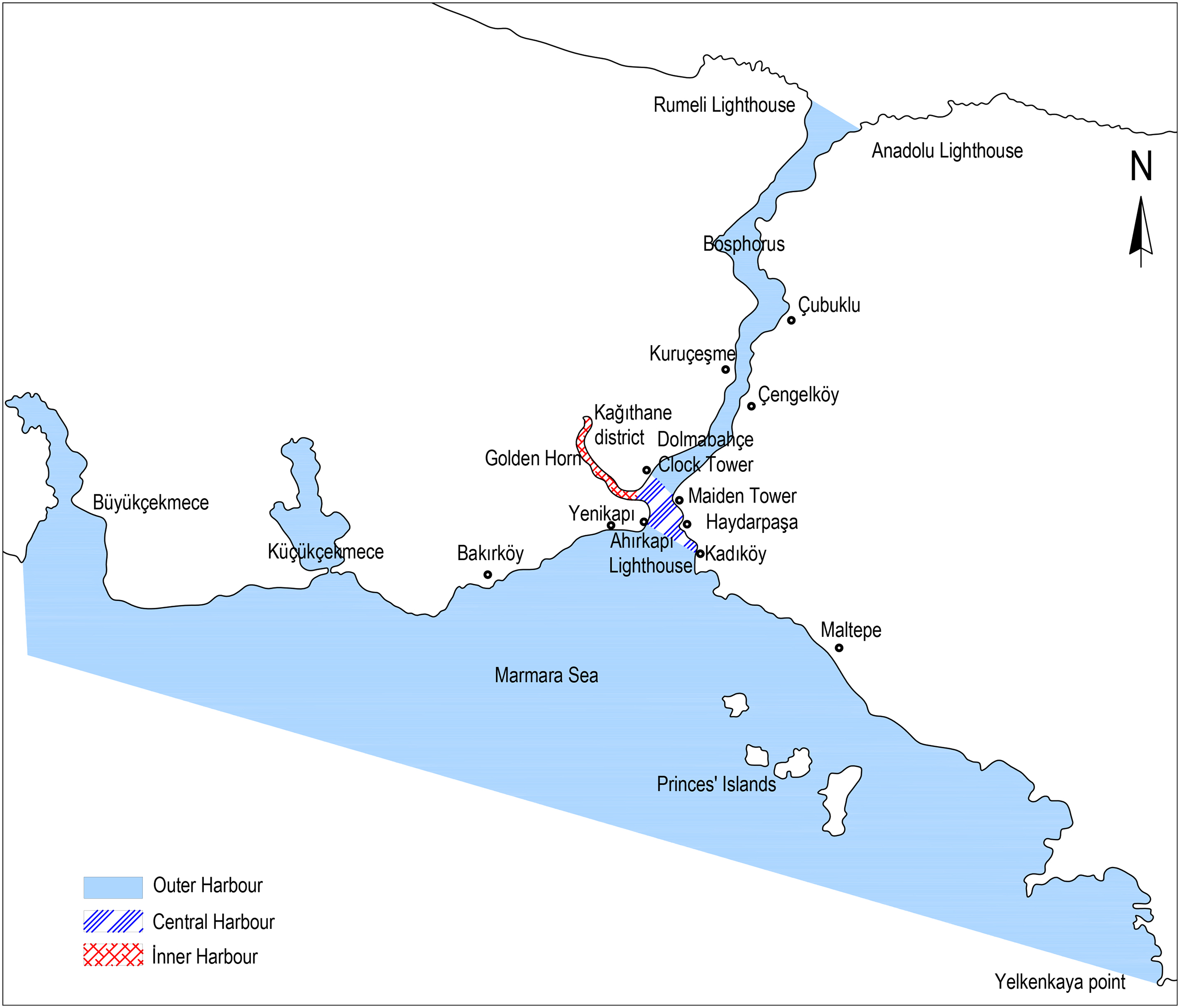
The fragmented port structure of Istanbul.
Ports in the byzantine period and structural elements of the city
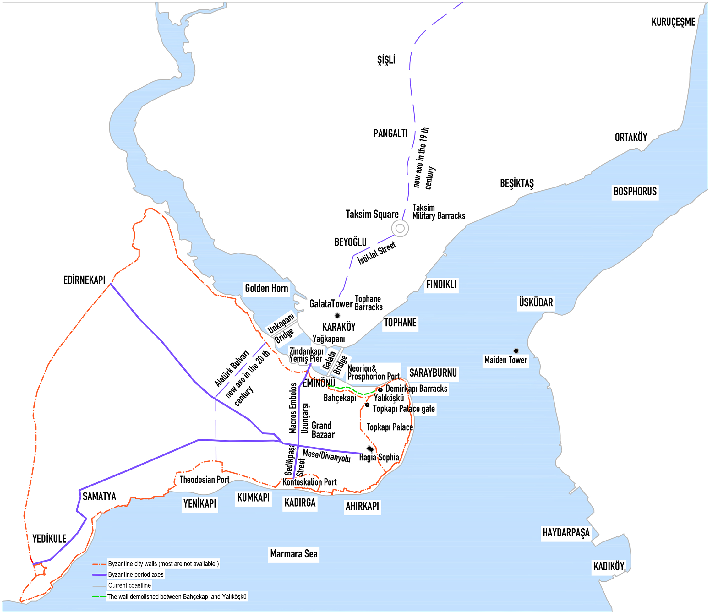
The port of Istanbul, as defined today, covers a large area between the Black Sea and the Marmara Sea, cross cutting the water highway from Europe to Asia. It is divided into three parts: inner, middle, and outer. The Galata Bridge is the border of the inner port, which extends to the Kağıthane district in the Golden Horn. To the east, the middle port is situated between Dolmabahçe Clock Tower, the Maiden Tower, and Ahırkapı Lighthouse. The Bosphorus extending from the Marmara Sea to the Black Sea is the outer port area. 12 The most special part of this fragmented natural harbour, which divides and surrounds every piece of land in the city, is the inner harbour area of Golden Horn, the founding element of the settlement (Figures 1 and 2).
The Istanbul historical Peninsula and its surroundings.
Until the Middle Ages, the defined port areas of the city were enclosed harbour pools encircled by piers of natural bays along Golden Horn and the Marmara Sea. In this period, the port was the sea. During the Byzantine Period, on the southern shores of the Golden Horn, there were two ports: Prosphorion near Sirkeci, where Venetian merchants settled with privilege, and Neorion 13 near Eminönü. Along the shores of the Sea of Marmara, there was the port of Iulianus/Kontoskayon in the area known today as Kadırga, and the port of Theodosiosin Yenikapı (Figure 2). 14
The main structural elements of Constantinople in this period were the city walls, urban gates, docks, squares and main roads (Figure 2). Some of these urban gates, located on the seawalls, used to open to the ports and docks. Today, it is difficult to read the city plan of Constantinus which differs from the grid plan used by the Romans for building the city. 15
Roads are significant in the structural organisation of the planned city (Figure 2). The major elements of this organisation are the Mese (Divanyolu), the east-west thoroughfare of Constantinople, and the main street cutting the Mese in north-south direction that connects the Golden Horn to the Marmara Sea. The northern section of this main street, which runs to Scala Major (Yemiş İskelesi),
16
is currently known as Uzunçarşı and its southern section which reaches the Kontoskalion on the Marmara shore, is called Gedikpaşa Street.
17
The street, called Uzunçarşı (Long Bazaar, as it continued its function as a bazaar during the Ottoman Period), passes through the Grand Bazaar in the centre of the city (Figure 2). According to Köksal, In the Byzantine Period, this road was a porticoed road named Makros Embolos Maurianos and, like all the main porticoed roads of the city, it had important functions: it was among the roads through which the Emperor passed, it provided transportation between the port and the centre, and it formed the border lines of the regions.
18
This street, which divides the peninsula along a north-south axis, is as remarkable as the east-west ceremonial axis of the Mese with its forums. This is because, during the Byzantine period, the street traced a direction towards Galata on the opposite shore, despite the absence of a connection over the Golden Horn. It can be observed that this street constituted a founding axis in the context of modern infrastructure projects designed in two different periods during the nineteenth century (Figures 3, 4, and 5). The proposed developments would establish a vital link between residential areas situated at a distance from the urban core and the new dock/port and station facilities via this thoroughfare. This route constitutes a crucial component of the terrestrial transportation infrastructure.
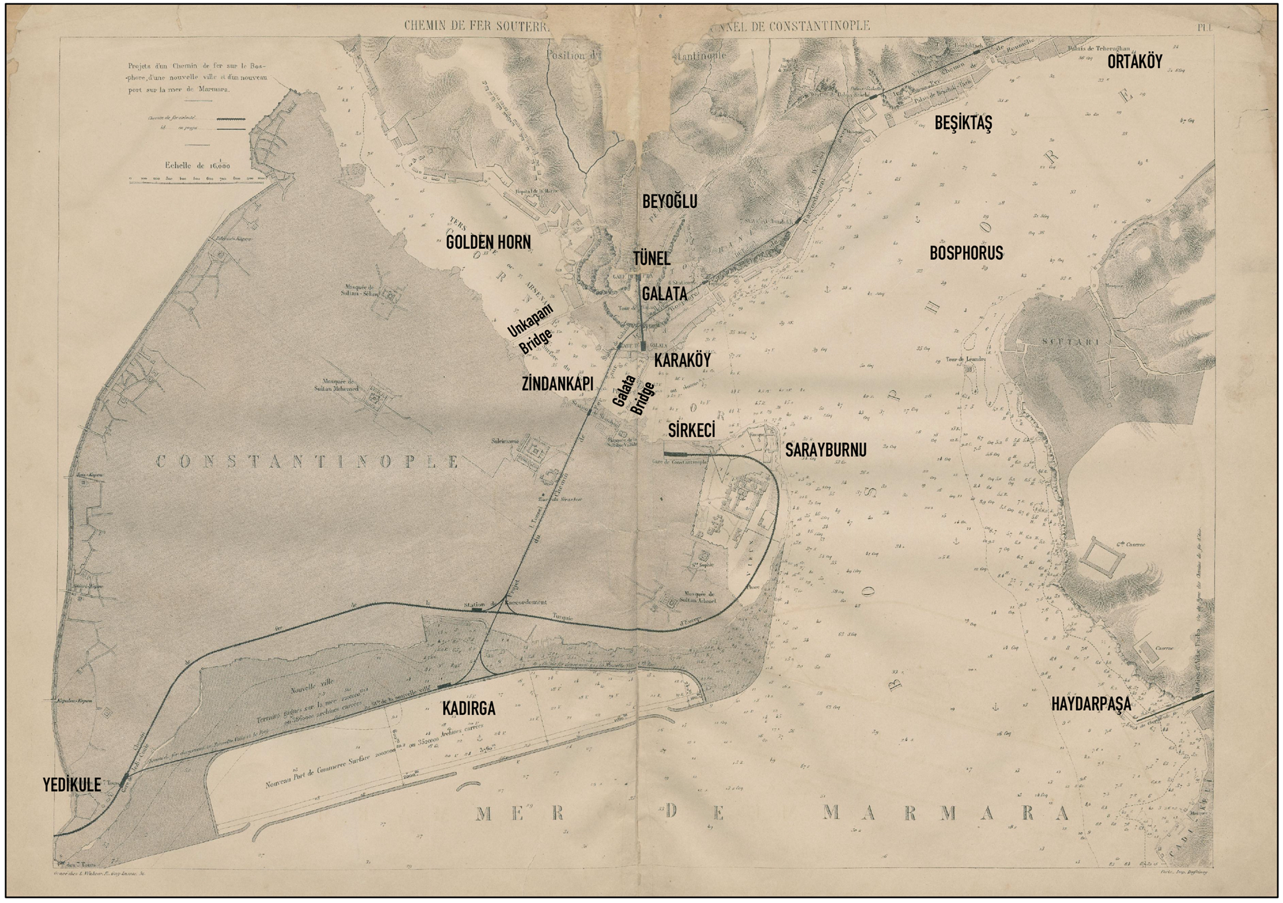
Istanbul's 1876 metropolitan railway project.
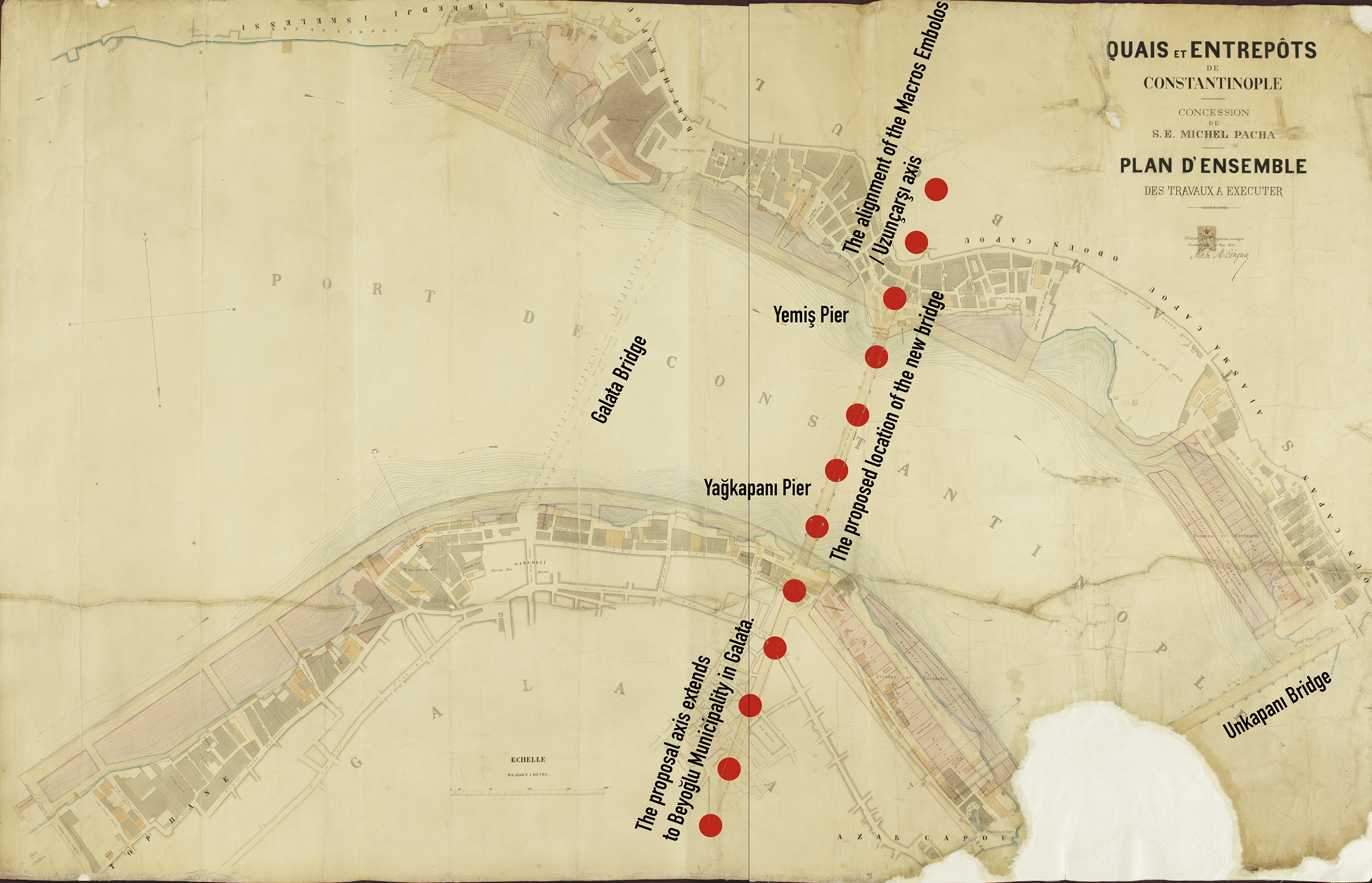
1881 Cingiria's plan, the new route of the Galata Bridge (colouring by the author). Source: BOA, Plan-project-sketch, No.: 181.
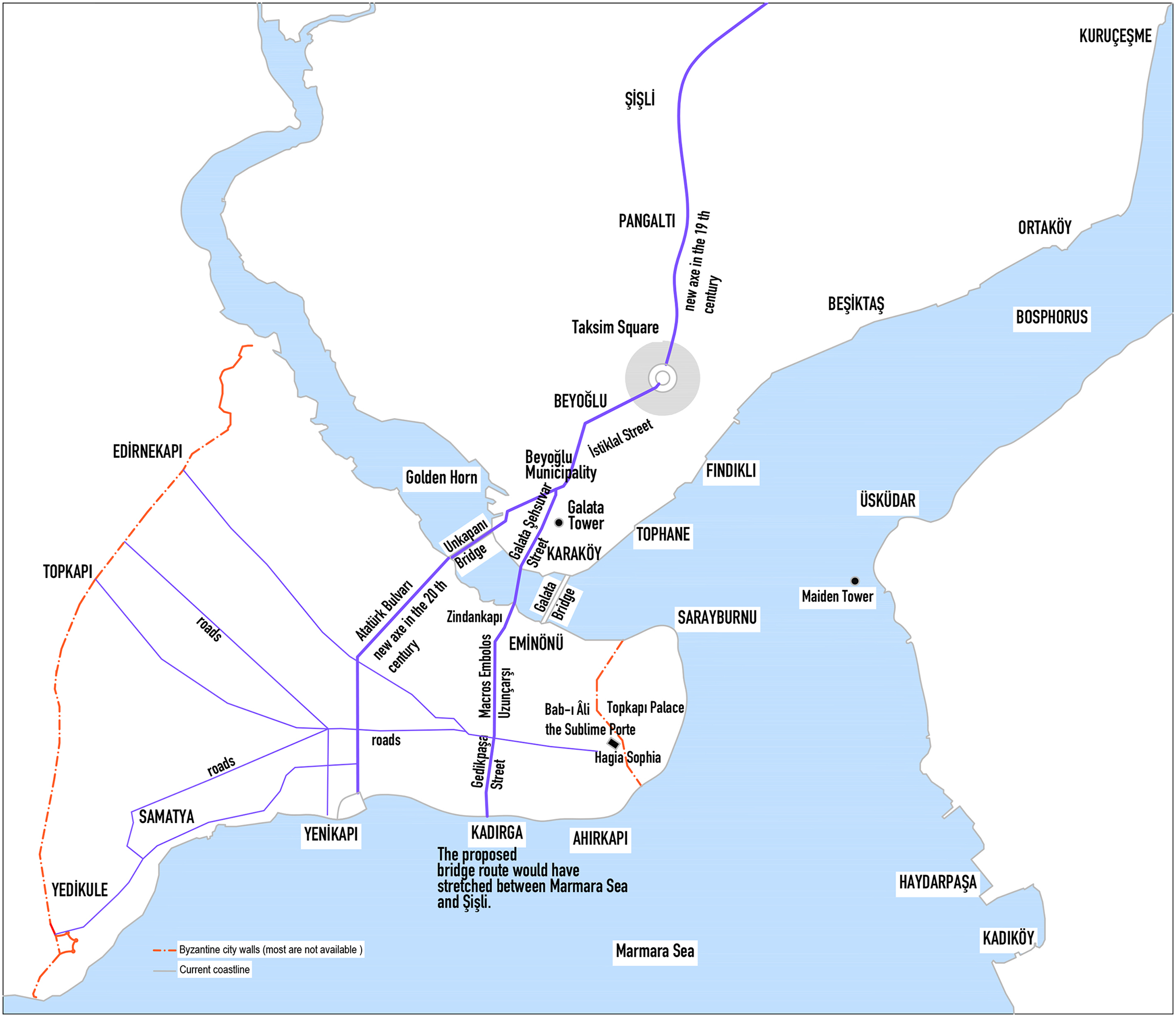
The proposed location of the new bridge on the Golden Horn, along a route extending from Taksim Square to Şişli in the north, and from Uzunçarşı (Macros Embolos) to the Sea of Marmara in the south.
As a result, these axes, which follow the basic elements of the ancient city structure, are still present as the basic elements of modern architecture, even though the urban fabric has changed significantly after repeated fires and especially during the modernisation period of the Ottoman Empire. The relationship between the axes connecting the piers and harbours to the ancient harbour areas, the piers built in the mid-nineteenth century, and the harbour projects of the twentieth century is noteworthy.
Port areas and spatial change in the Tanzimat period
In the mid-eighteenth century, Istanbul became part of the European-centred urban network as it integrated into the global economy. 19 The port cities of this network were privileged passages that facilitated interactions between the actors who played roles in the transformation of the urban structure within capitalist economies. In the late 1830’s, with the Tanzimat reforms, the state began efforts to create a modern identity in European style, which were reflected in the urban space, primarily in the port area. The priority of constructing these modern infrastructures was based on establishing a control network centred on the capital city with the aim of military and economic development. For example, during the reign of Mahmut II (1808–1839), stone piers and a coastal road were planned between the Tophane Barracks on the Galata coast, the Demirkapı Barracks at the Yalıköşkü gate of the palace opening onto the Golden Horn, and the Unkapanı Bridge (Figure 2). The text reflecting this vision also covered the planning of main roads within the city, squares near the port and fire areas. 20 In the nineteenth century, Istanbul consisted of a dense urban fabric made up of wooden buildings and dead-end streets inhabited by a growing population. Due to the lack of modern fire-fighting equipment, many neighbourhoods were damaged in the frequent fires that occurred. According to the report in question, the newly proposed road network would not only facilitate access to the port area and railway stations but would also be effective in extinguishing potential fires.
On the other hand, Ottoman ambassadors traveling to Europe praised the security and order in European cities in their letters. Therefore, under the modern municipal organisation established by the Tanzimat, urban transformation was initiated through the reconstruction of fire-damaged neighbourhoods. This process introduced standardised building blocks for taxation and a European-style road network designed to enhance state control. 21 Yerasimos states that one of the reasons for the Tanzimat reforms was to modernise the state and society by drawing on Western technology and culture. Another explanation was to consolidate the authority of the central modern state. 22
In summary, the areas surrounding the administrative and port zones in the city centre began to be transformed with a modernising approach, aided by the opportunities created by the fires.
The most significant urban development project of the nineteenth century was the construction of the second bridge, the Galata Bridge, which connected the two sides of the Golden Horn in 1845. 23 This bridge brought not only the trade centre of the Istanbul peninsula and Galata closer together, but also the embassies in Galata and the Sublime Porte. The mobility between the two sides uniting by the Galata Bridge gained pace once the city walls in Galata were demolished in 1864. On the opposite coast, in the İstanbul Peninsula, a project was prepared in 1864 to demolish the walls between Yalıköşkü and Bahçekapı (Figures 2 and 6). İt was carried out after the 1865 Hocapaşa fire, which destroyed a large area from the Golden Horn to the Sea of Marmara. 24 Only the section of sea wall that surrounded the city between the Topkapı Palace Gate on the Golden Horn and the Galata Bridge was removed (Figure 2). This was a sign of the transformation of the commercial areas on either side of the Golden Horn following the construction of the bridge. Thus, the city centre, the bazaar, and administrative district were restructured after the 1865 Hocapaşa fire.
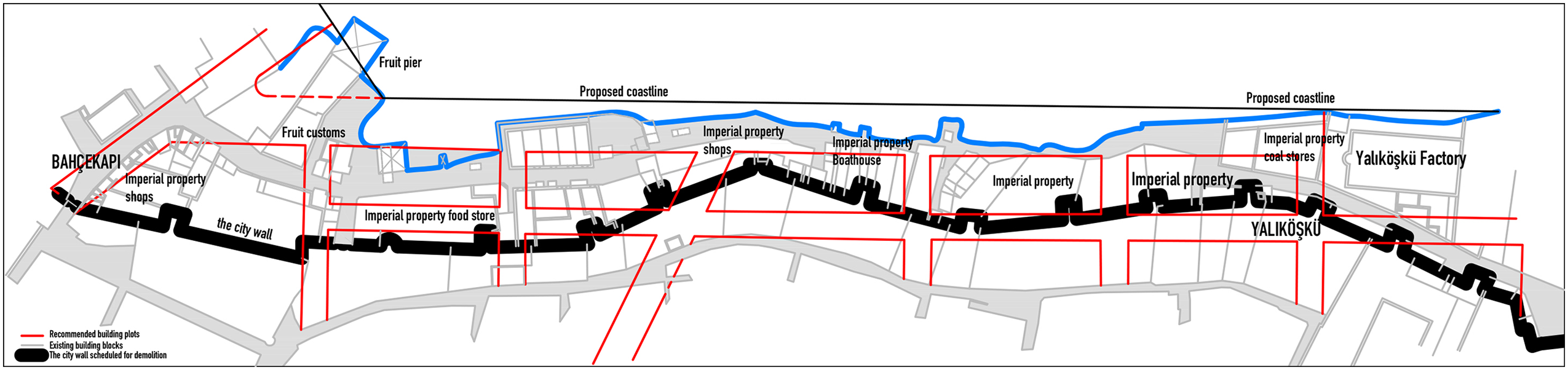
The 1864 coastal redevelopment between Bahçekapı and Yalıköşkü (Demirkapı). Source: Adapted from İstanbul Büyükşehir Belediyesi Atatürk Kitaplığı [İstanbul Metropolitan Municipality Atatürk Library]), Istanbul (İAK), (Hrt-005828).
Over time, the capital gradually transcended its natural and artificial borders, and expanded to the north of Galata, to the Bosphorus, and to the western and eastern sides of the Marmara shores.
First, in 1848, in the north of the Golden Horn, an artery passing in front of Taksim Military Barracks and extending from Taksim to Şişli was created. Moreover, a neighbourhood was planned in Pangaltı, on this artery. The wide street connecting Taksim and Pangaltı was completed in 1869, including an extension to Şişli (Figure 2). 25 The removal of the boundaries separating the peninsula and Galata from the coast and the construction of a bridge connection constituted a pivotal moment in the planning of the coastal line and the materialisation of the port and pier projects. With the emergence of modern life in Beyoğlu district (between Galata Tower and Taksim square), it was inevitable that the city would develop towards the city's north, accompanying its growing population (Figure 2).
The removal of the city walls and the bridge connection in the Istanbul peninsula and Galata were also instrumental in the planning of the coastal line and the completion of the harbour and dock projects. The old harbour pools, which filled up over time, were reconstructed on an embankment with modern infrastructure facilities such as stations and docks. 26 In the nineteenth century, the modern port was represented by land rather than sea. 27
Although the relation of the new harbour region (created once the city walls were demolished) with the urban fabric differs from the permeable relation between the walled city and the harbour in antiquity, the nineteenth century was the period when modern harbour projects in the historic harbour were presented.
In the process of modernisation, in the new city image that the state wanted to create, in the port area, which had an international economic vitality from the shores of Sirkeci and Galata to scattered settlements, ferries were introduced in the 1850s and trams in the 1870s. During this period, the railway from Sirkeci to Europe was opened, and the central station was built at Sirkeci, at the mouth of the Golden Horn and next to the Galata Bridge. According to İlber Ortaylı, the emergence of Karaköy (Figure 2) as a second business centre associated with the residential area of Beyoğlu turned this area into a transition zone reflecting cosmopolitan life. 28
The Galata Bridge's transit zone extended to the Eminönü waterfront (Figure 2). However, despite connecting the city's modern Galata waterfront with the old market area, the location of the bridge has consistently been criticised. For example, both local and foreign steamship companies applied to the Ottoman state to move the Galata Bridge back towards the inner harbour area, as they were experiencing difficulties entering and exiting the harbour. The proposed location pointed to the important Byzantine bazaar axis, Makros Embolos Maurianos (Uzunçarşı). In this case, the location of the new bridge connecting the two sides of the Golden Horn would affect not only the direction and route of urban development between Istanbul and Galata, but also the new harbour and the city's trade and development areas, extending to the Marmara Sea.
This route connecting Galata and the Historical Peninsula by extending along Makros Embolos to Kadırga is seen in French engineer Eugène-Henri Gavand's New City Project of 1876. 29 Gavand proposed a large reclaimed area and a harbour between Yedikule and Sarayburnu, which he carried out during the construction of the Galata Tunnel (1871–1874). The tunnel line between the stations to be built in Kadırga and Zindankapı would follow the new bridge route, reach Galata and connect to other tunnels through stations that would be set up at four different points parallel to the coast up to Ortaköy (Figure 3).
The Byzantine market road (embolos) was one of the founding axes of the nineteenth century harbour infrastructure reconstruction projects (Figures 3, 4, and 5). In Gavand's urban project, the bazaar axis extended the transition zone, which Ortaylı defines as the cosmopolitan encounter area of the modernising city, beyond the Golden Horn and Galata to the Marmara Sea, Küçükçekmece, and the Bosphorus coasts of Istanbul (Figure 1). This also determined the city's new spatial development direction.
After the projects prepared by Louis Barett in 1872, engineer Hilarion Pascal in 1873, and architect Alphonse Cingria in 1898 were not implemented, French architect Marius Michel finally undertook the construction of a port on behalf of Société des Quais, Docks et Entrepôts de Constantinople, with two agreements signed in 1879 and 1890. 30 According to the first agreement, the piers would continue on both sides of the Golden Horn between the Galata and the Unkapanı Bridges. 31 Prior to the 1890 agreement, the project prepared by Cingria (Figure 4) proposed to relocate the Galata Bridge and build a new bridge in the narrowest section of the Golden Horn, between the Yemiş Pier in the south and the Yağ Kapanı Pier in the north (several bibliographic resources have stated that the bridge would be relocated, but this text mentioned the exact location for the first time). However, the Unkapanı Bridge would have to be raised, as the shorter distance between the bridges would prevent the navigation of large ships. 32 The new location of the Galata Bridge in this project defined not only the pier areas on the opposite sides of the Golden Horn but also the new urban artery that would replace the walled city and the Galata district, from the Marmara Sea, including Şişli in the north (Figure 5).
This artery followed once more the busy commercial artery of the Byzantine Period, Makros Embolos Maurianos, towards Galata Şehsuvar Street (Şair Ziya Paşa Caddesi) and tangent to the Arab Mosque to the north. It ran towards Giovanni Battista Barborini's neoclassical landmark, Altıncı Daire-i Belediye, in Beyoğlu Municipality, and passed through Istiklâl Street to Taksim Square, finally reaching Pangaltı and Şişli, which had been developed in 1848 (Figures 5 and 7).

The route of the new bridge (Şehsuvar Street) heading towards Beyoğlu Municipality and the recommended route (Haraççı Street) from Karaköy to Galata Tower (colouring by the author).
Henri Gavand's Galata Tunnel Project of 1875 facilitated access to Istiklal Avenue. In the 1880s, an electric tramway line was opened on İstiklâl Street (Figure 5). At the same time, a new road was proposed to connect the Galata Bridge to the Galata Tower square (Figure 7). 33
If all the projects in the port area were implemented, settlements far from the city would be able to reach the new dock/port and stations via Uzunçarşı Street, which is an important part of the terrestrial transportation network. However, the layers of the historic city would have been removed in the search for a modern identity, which could have damaged the historic identity of the city.
Depending on the developing trade network at the end of the century, harbours in important port cities of Europe increased their capacities with modern projects. However, despite the construction of modern embankment docks during this period, Istanbul's existing harbour lacked the capacity to compete with European harbours. For this reason, new modern port projects have also started to be considered on the Marmara coast, far from the city centre. Firstly, in 1856, the transformation of Küçükçekmece Lake into a harbour and the construction of a railway from the centre to this region were put on the agenda. Then, in 1871, the Mediterranean Forges Shipping Company submitted a report to the Ottoman Empire recommending the conversion of Küçükçekmece Lake into a harbour, as the natural structure of the Golden Horn and the Bosphorus was deemed unsuitable for large commercial harbours. 34
Moreover, Cingria's 1881 project of dock and warehouse buildings in the Golden Horn offered a perspective that would move the bridge relocated in Istanbul. Additionally, the administrative centre Bâb-ı Âli, the Sublime Porte (Figure 5), and the trade centre would move to the northern side of the city, and Küçükçekmece would connect to Galata, which was accessible via the railway built in 1871. 35
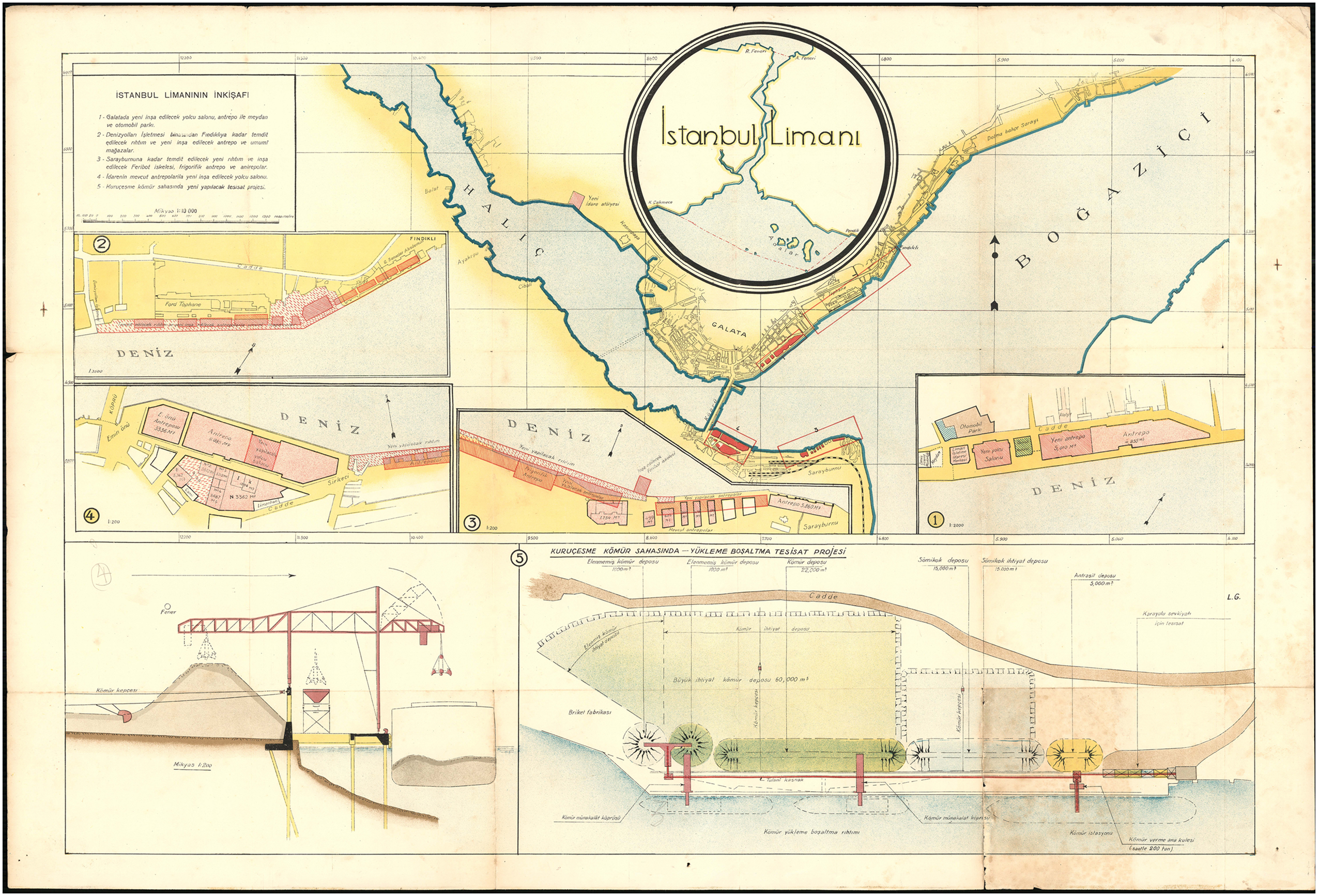
A few years later, in 1884, a report sent to the Grand Vizier by engineer Joseph Isella proposed a large commercial harbour project with a capacity for 800 ships on Lake Küçükçekmece 36 (Figure 8). The project included the construction of a harbour in Küçükçekmece and docks in Galata and Eminönü. Moreover, it was close to the Edirne railway. Because the weather is pleasant in Küçükçekmece, a Köşk-ü Hümayun (mansion for the sultan) facing the port and close to the railway, was planned, adding to large stores and warehouses, a bridge for passengers and goods, an ambassador's mansion, quarantine and a police station built (Figure 8 and Figure 9).
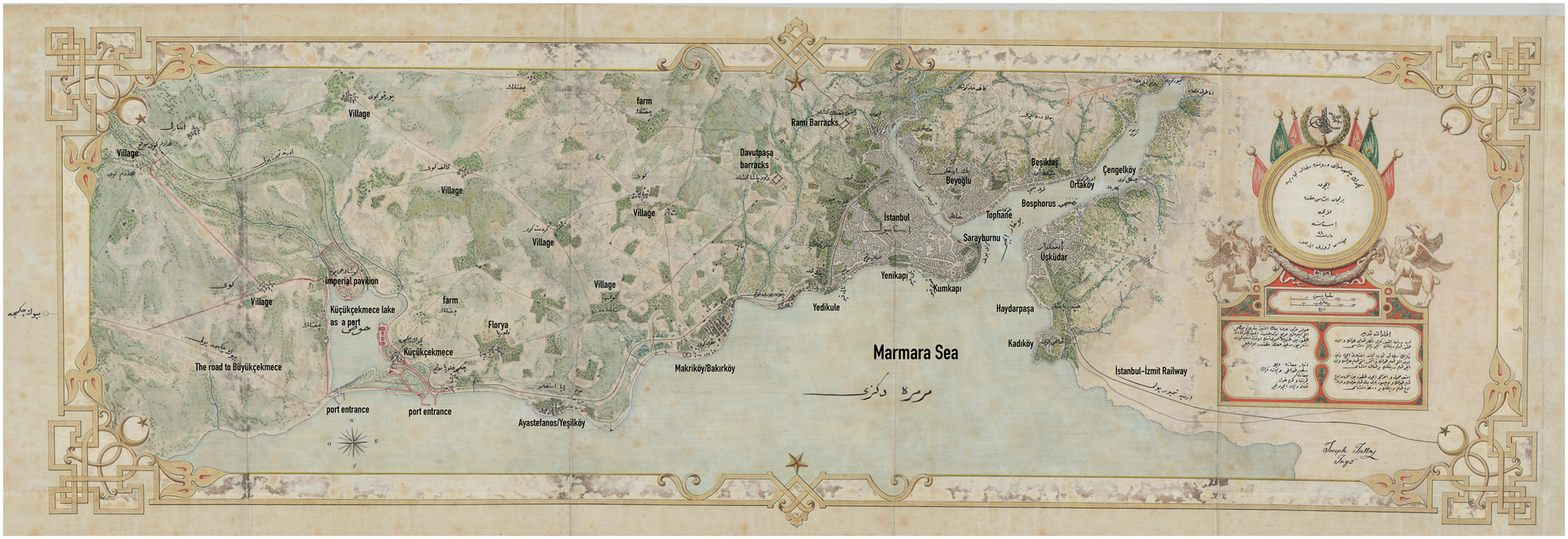
Trade Port in Küçükçekmece, piers connected to the large port in Galata and Eminönü in Istanbul (project by engineer Joseph Isella).

Trade port and buildings inside the harbor in Küçükçekmece Lake in the project proposed by engineer Joseph Isella.
Although a commercial port in Küçükçekmece, far from the city centre, was not costly, the dock projects on the Golden Horn proposed by Marius Michel's company were preferred. Ultimately, only the docks to the east of the Galata Bridge were constructed on both sides without the bridge being relocated (Figure 10). However, the embankment docks constructed in the old customs areas at the mouth of the Golden Horn had a buffer zone character that did not integrate with the urban fabric behind it. 37 The built docks were inadequate and the density of different functions in the urban interface posed a problem.
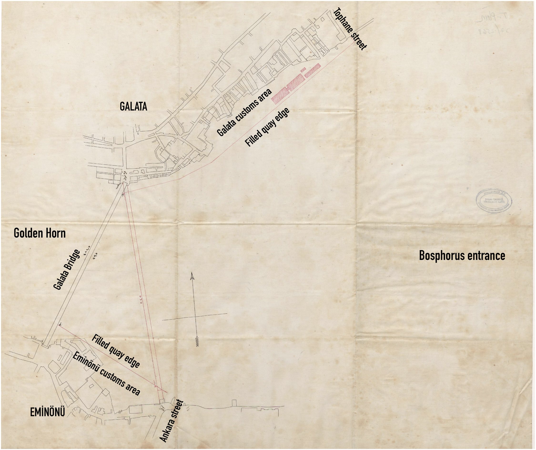
Geometric survey of the boundaries of the Galata and Eminönü quays.
In 1893, Cingria once again proposed a wide boulevard lined with stores from the Sirkeci pier to Ahırkapı. 38 The impact of this project on urban development was later apparent when French urban expert André Auric prepared a plan following the 1912 fire in Ishakpaşa (the area to the southeast of Hagia Sophia) proposing wide streets running to the shoreline. 39
In fact, years before Cingria, engineer A. De Landseé, representing banks of Israel and Moscow, and a group representing Viennese bankers Knaffl and Fohndorff established a construction company on 7 September 1872 and proposed the construction of a boulevard between Ahırkapı and Yedikule and between Beyazıt Square and Marmara coast, besides a tunnel between Otluk Gate and Sirkeci Station on the Marmara coast (Figure 11). 40
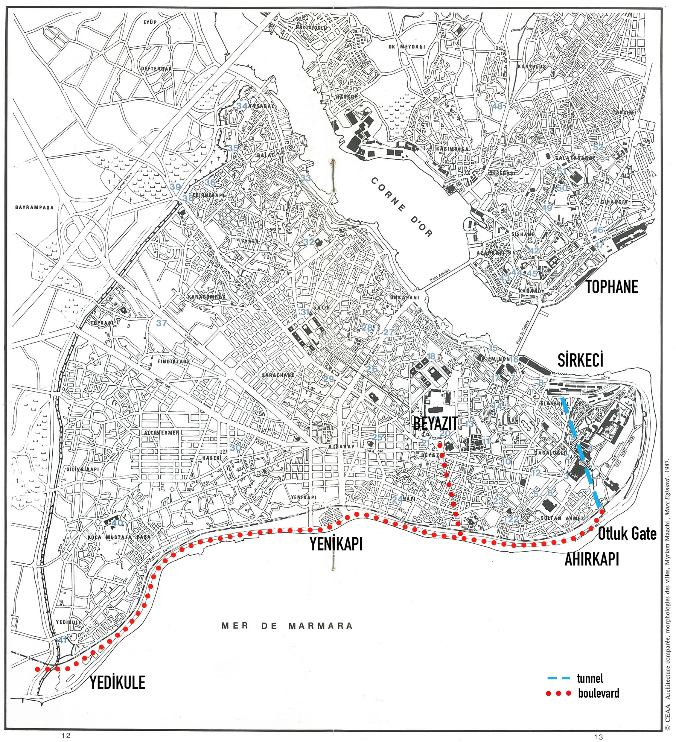
The proposal of engineer A. De Landseé to the government to build a boulevard between Ahırkapı-Yedikule and Beyazıt Square-Marmara coast, a tunnel between Ahırkapı-Sirkeci Station, and modern buildings around the boulevards (colouring by the author).
The most important factor in the transformation of Küçükçekmece Lake into a port, despite its location far from the city centre, was the railway. Sirkeci was chosen as the railway's central station. However, it was not considered right that the railway to pass through the garden of Topkapı Palace on its way to Sirkeci. Consequently, the idea of a tunnel from the palace gate (Otluk Gate) at Ahırkapı on the Marmara Sea coast to Sirkeci on the Golden Horn coast was developed. According to this project, along with the spatial transformation based on the class settlement model, the new roads opened would facilitate access to the city for the tradesmen and workers who were envisaged to live here. The surrounding lands would increase in value, and a large contribution would be made to the state treasury through their sale. In the nineteenth century, projects for modern port infrastructure on the Marmara coast from the Golden Horn to Yedikule and even Küçükçekmece signalled the transformation of the urban space with a modern identity in addition to its economic and logistical functionality, and a new way of life on land under the control of the state instead of the traditional inward-oriented lifestyle. Until the nineteenth century, social life in Istanbul unfolded inwardly within neighbourhoods shaped along ethnic and religious lines. The reform initiatives launched by the Ottoman administration in the 1830s affected everyday life profoundly. With the onset of modernisation, the infrastructure works carried out in the city centre transformed the port and bazaar districts into spaces where social classes from different segments of society came into contact.
In these projects, which were envisioned on the periphery of the city and envisaged spatial development and expansion, the most important factor, along with urban transportation structures such as trams and ferries, was the Rumelia railway reaching Europe. Following Sultan Abdülaziz's (1861–1876) approval for the railway to pass through the palace garden, plans to link the shores of the Golden Horn and the Marmara Sea, as well as the city's main roads and squares from the Byzantine era, were developed.
In summary, the urban transformation projects initiated by the state under the leadership of Ottoman intellectuals in the late 1830s ranged from the port area in the city centre, primarily near the palace, to the neighbourhoods on the periphery. The modern lifestyle that emerged in Beyoğlu spread northwards to Şişli following the removal of the city walls. It also spread to Eminönü, the traditional bazaar district on the Istanbul peninsula, following the construction of the Galata Bridge. The neighbourhoods following the modern urban transport network intersected with the city centre and the port area, where modern life took place. İlhan Tekeli conceptualises Istanbul's urban form in the nineteenth century as intersecting bands in the centre. During this period, which Tekeli termed the ‘Shy Modernisation Period’, Istanbul's modernisation was characterised by a Europe-centric, dependent and top-down structure. 41
Alternative port areas in the early twentieth century
The modernisation initiatives centred on Europe and initiated by the state under the leadership of Tanzimat intellectuals—referred to as westernisation in the literature—were implemented in urban spaces by foreign companies. Towards the end of the century, a constitutional parliamentary programme was established by Muslim intellectuals with nationalist views, the New Ottomans, Muslim intellectuals with nationalist views; however, the sultan of the time, Abdülhamit II (1876–1909), dissolved the parliament and returned to authoritarian rule. In 1908, İttihat ve Terakki Cemiyeti reestablished the parliament through a revolution and a year later Abdülhamit II was deposed. 42
The modernisation programmes determined by the leaders of İttihat ve Terakki Cemiyeti from the beginning of the twentieth century until the proclamation of the Republic were also reflected in the urban space. The development of modern transport infrastructure was a priority during this period. The construction of the power station in the inner area of the Golden Horn was an important step in the city's transformation. The electric tram lines within the city made it easier to access more distant settlements. In addition, some of the Muslim population from lands lost by the Ottoman Empire during the Balkan Wars were settled on the outskirts of Istanbul, primarily in Anatolia. The railway and port infrastructure providing access to Anatolia was one of the steps by the İttihat ve Terakki Cemiyeti to modernise the country, to spread their ideas from the centre to the provinces. For this reason and because the Golden Horn no longer served the needs of the city, new harbour projects began being developed in the middle port area, between Haydarpaşa and the Marmara Sea.
The quay project in Haydarpaşa had emerged in the 1870s based on the idea of a railway network extending from Istanbul to Anatolia. In the 1850s, the Ottomans only benefitted from the railway network in the Aegean Region in Anatolia. In the 1870s, as the loans and privileges granted to foreign companies fuelled criticism, together with the perspective of the İttihat ve Terakki to create a national bourgeois class, it was decided that the railway network in Anatolia should be built by national companies. The first step of the railway project, connecting Istanbul to Baghdad, was carried out between Haydarpaşa and Izmit in 1871. 43
Haydarpaşa Harbour was rapidly completed through an array of privileges given to the Société du Port de Haidar Pacha, which had been established with German capital in 1900. The harbour was inaugurated in 1903. 44
The difference of the Haydarpaşa harbour compared to the modernisation of the historical harbour in the Golden Horn was not the transformation of the existing harbour but the fact that it was constructed in the area which had been recently planned.
Şehremini (mayor of the Ottoman Empire) Cemil Paşa (Topuzlu) who took office in 1912–1914, adopting a reformist perspective of local administration, had a prominent role in the rearrangement of the fire services, infrastructure, and transportation services, including the location of the port and the future planning of the city. Cemil Paşa was followed by the administrations of Ismet Bey (1915) and Ismail Canbolat Bey (1916), whose urban planning reports emphasised the intimate relationship between the primary streets and squares of Istanbul and stations, customs houses, and ports. 45
Under the administration of Şehremini Bedri Bey (1915–1917), the potential sites for a reclamation port were Kumkapı-Yedikule (first stage: Yenikapı-Yedikule, second stage: Kumkapı-Yenikapı) and Lake Küçükçekmece (Figures 1, 2, 12, and 13). 46 Eventually, the area between Kumkapı and Yedikule, which included a vast reclamation area of 300,000 to 500,000 m2, was chosen as the most appropriate for the port. 47 Due to the Battle of Çatalca against Bulgaria, the harbour project in Küçükçekmece was abandoned. Moreover, the port project between Kumkapı and Yenikapı gained priority because of its proximity to Haydarpaşa.

The projected port of Istanbul between Kumkapı and Yedikule.

The projected port of Istanbul projected in Küçükçekmece.
As a result, it became clear that it would be economically difficult to build a large port in Küçükçekmece due to the need for storage facilities for materials such as timber, coal, oil, petrol, gasoline, iron, and bricks, and the many consumption points scattered throughout the customs area. Furthermore, building a railway line between the customs area and the port would cause operational problems, while the extension of the city to Bakırköy and Yeşilköy (Figure 1) and the construction of buildings along the coastline were not considered appropriate. Ultimately, the First World War led to the cancellation or non-implementation of the envisaged projects.
After the war, modern infrastructure and urban transformation projects gained momentum. Those projects were designed to connect districts divided by Istanbul's fragmented natural harbour structure to the city centre via sea and land transportation networks. However, they did not materialise due to wars and economic conditions in the last days of the empire. Rather than evaluating these endeavours as a loss or gain for Istanbul, it is more constructive to question the historical identity formed by the city's natural harbour with the Republic.
İstanbul harbour during the early republican period
Discussions on building a modern port continued after the establishment of the Turkish Republic. During the mayorship of Emin Bey (Erkul), in 1924, a competition to create a 10-year development plan for Istanbul suggested the demolition of the walls between Sarayburnu and Yedikule (deemed devoid of any architectural or historical value) and their replacement with piers. 48 The historical value of Istanbul's urban transformation was ignored during Emin Bey's period.
The municipal magazine of the period, Şehremaneti Mecmuası, published opinions on the development of Istanbul and its harbour. In one of its issues, Ali Suad Bey, one of the municipality's economic advisors, cited various European ports, such as Hamburg, Copenhagen, and Trieste, as examples. He emphasised the importance of the port as an economic, industrial and commercial zone, and proposed the creation of a free zone exempt from customs duties. Additionally, he proposed the construction of factories, workshops, warehouses, and employee housing. Ali Bey presented the project as a state-controlled structure, with local administrations and chambers of commerce governing it. 49
However, Istanbul's fragmented natural harbour structure between the Golden Horn, Marmara and the Black Sea allowed for dispersed settlement with modern transport infrastructure. Space is shaped by production and transport infrastructure. Under the title of social space Henri Lefebvre states that space is formed by relations of production and is limited to certain places. 50 When examining the development of Istanbul's urban form, the construction of a large, modern harbour was fundamentally dependent on the city's unique geographical and topographical features and on choosing a place, which was not considered separately from place. In this context, the location of ports and railway stations was determined by physical, logistical, and geographical factors.
A report prepared by the municipality in 1926 divided Istanbul's fragmented natural harbour structure into different functional areas, proposing separate districts for harbour services:
Free zone for transit: The indented coastline between Yenikapı and Samatya was considered suitable for the free zone while the length of the coast was appropriate for landing and constructing a breakwater; moreover, the railway connection to the city was seen as an advantage (also for the transportation of poor workers); expropriating abandoned vegetable gardens and fire zones to make way for the new buildings was deemed feasible; another advantage was the orography of the construction ground, mostly flat; the stones from walls in the area could also be used in filling the sea; finally, the Atatürk Boulevard (Figure 2) would connect Yenikapı to the Golden Horn, from where a network of tramlines expanded the transportation grid. Customs export and import zone: Galata was considered appropriate for the customs area; however, during the 1920's the area on the coastline was too narrow and short; but it could be possible to make use of the land from Tophane Square to Fındıklı (Figure 2) expropriations would be easy, because the land was mostly glebe; facilities for processing, cleaning, and packaging the exported goods could also be built in this area; the income from the sales of the existing Galata Customs area would assist the construction of the new pier. Passengers’ zone: Sirkeci was deemed appropriate for this zone, mostly because it was close to the Golden Horn and had tramline connections; furthermore, Sirkeci had an image that was not worthy of the city, and it would be granted a new aesthetic image once the passengers’ zone was built. Orient Train: Sirkeci Harbour was appropriate for passengers only; a new railway was planned to land crops to the pier, which would be extended from Ahırkapı Lantern to Kumkapı; moreover, coal yards therein were to be removed. Crops and Animals Zone: planned for Maltepe (Figure 1). Coal zone: planned for Kuruçeşme (Figure 1). The ships coming from the coalfields in Black Sea would land easily. Timber zone: Çengelköy (Figure 1) was deemed appropriate for stevedore of the timber coming from the Black Sea. Fluid and inflammable materials zone: planned for Çubuklu (Figure 1)
51
; Atatürk Boulevard would connect the new transit zone at Yenikapı (Theodosius Port) to the Golden Horn (Figure 2).
In 1930, the Chamber of Commerce proposed the construction of a free port on the northwestern shores of the Golden Horn and extending the Galata and Istanbul piers to Dolmabahçe and Sarayburnu (Figure 14). 52 A proposal to demolish the Galata bridge was put on the agenda again, with a boulevard planned between Unkapanı and Yenikapı, instead of Karaköy-Eminönü. 53
Istanbul port development.
As in the example of Ford free zone, 54 there would be no need for an extra budget for the free zone of the harbour to be built in Golden Horn. The factories and companies that would rent the land for long terms would be able to cover the expenses of the construction of the required facilities. In the former customs areas of the city, the filled piers constructed during the nineteenth century were not sufficient for direct landing, while the storage units, cranes, and parcel cars were inadequate, which motivated the development of extension plans. However, these proposals were not exclusively long-term plans. Furthermore, the width of the pier, which separated the city via magazines and a public street, was not sufficient for including all these facilities.
Besides the demolition of the Galata bridge, the transfer of the port to Yenikapı was proposed again. 55 The new bridge route pointed to the boulevard from Unkapanı to Yenikapı. 56 The boulevard that divides the Istanbul peninsula from north to south was built and named Gazi Boulevard (Atatürk Boulevard) in the Master Plan prepared by Henri Prost in 1937.
The first step to build the boulevard along the Unkapanı Bridge axel in the Istanbul peninsula was taken by Italian urbanist Luigi Storari, following the 1854 Aksaray fire. Storari proposed a new urban texture with a rectangular street system. The street which extends in the north-south axis of the 1857 grid street plan is the current Atatürk Boulevard. In the period between 1936 and 1937, the boulevard proposed by Henri Prost in his masterplan constituted the principal component of the sea/land transport network, facilitating the connection of different settlements in the natural harbour structure of Istanbul. The resulting division of the historical peninsula into two distinct entities is a notable consequence of this process.
In the Early Republican Period, competitions were organised for the planning of Istanbul. Architects specialising in urbanism from Europe participated in these competitions with projects close to the Republic's ideal of modern Turkey. Among these experts Herman Elgötz proposed to expand and revive the historical roads surviving from the Byzantine Period, 57 while Jacques Henri Lambert proposed a large port between Kumkapı-Bakırköy. 58 In 1936 and 1937, Henri Prost's masterplan included a proposal to extend the Galata Port up to the Academy of Fine Arts, to build an international station where Atatürk Boulevard reached the Marmara Sea and a promenade between Sarayburnu and Eminönü, and to move the Galata Bridge towards the Golden Horn. 59
The proposals of these three urbanists were reminiscent of the pier projects previously designed but not implemented. From a contemporary point of view, the pier and port proposals for the shoreline extending from Kumkapı to Yedikule and from Galata to Dolmabahçe, and even up to Ortaköy on the Marmara coast, were alarming. Fortunately, these projects were never implemented. There is an evident discrepancy between the critiques and the proposals concerning the İstanbul harbour compared to those modern examples in the West. Ahmet Hamdi Başar, manager of the Istanbul Harbour Monopoly Company indicated that the modern harbour consisted of facilities on the land, not the sea. He also emphasised that the natural harbour characteristic of Istanbul should be utilised, and advocated the renovation of the former harbour by clearing the bridges instead of creating an artificial pier facility in the open sea. 60
Following the Ottoman Empire's failure to service its external debts, the Public Debt Administration was established in 1881, placing the production and sale of revenue-generating goods under the control of the creditor states. In the Republican era, this structure was altered, and these operations were reassigned from foreign creditors to Turkish joint-stock companies. 61
Therefore, the arguments concerning the Istanbul harbour's location, management, and its functions in the reports prepared during the early republican period are dominated by liberal perspectives. In 1929, following the global economic crisis, the infrastructure investments and management were reformed with a statist understanding. The establishment of Ankara as the new capital city and the subsequent construction of the Anatolian network projects were pivotal developments for the country. In summary, during this period, the concept of modernity, alongside the vision of Istanbul and modern Turkey, was relevant not only to Istanbul, but also to all Anatolian cities.
Conclusion
This paper analysed the role of port and transport infrastructure in Istanbul's transition from the Ottoman Empire to the Republic, examining projects that were and were not implemented. The orientation of spatial development shaped by Istanbul's port infrastructure and intra-urban transportation network, which stands at the centre of this study, represents one of the urban manifestations of the state's modernisation efforts. In this regard, modernisation, planning, and the relationship between power and space constitute the conceptual framework of the article.
The transformation that the Ottoman Empire underwent in the nineteenth century has often been analyzed as a case of modernisation shaped by a process of exploitation consistent with Wallerstein's peripheralisation model, driven largely by the rapid expansion of Western economic and political power. Alongside this external dynamic, scholars have also emphasised an internal motive: the effort to consolidate the state's central administration and authority. In this context, urban space became the primary arena in which the Ottoman modernisation project—initiated in the 1830s with the reforms known as the Tanzimat—was implemented. These spaces were permeable urban areas, easily accessible and regulated by state apparatuses, where European-style modes of modern life emerged and where populations of diverse class and ethnic backgrounds came into contact.
Following the frequent fires in Istanbul, fire zones reconstructed in accordance with Tanzimat principles and modeled after European cities transformed the traditional inward-looking neighborhood fabric into a more open and permeable structure. In the city centre, the port and commercial districts underwent significant changes through modern infrastructure projects and new modes of transportation, becoming focal points that attracted the population of Istanbul's periphery.
In addition to the orientation from the periphery to the centre, the fragmented natural harbour structure of Istanbul, which is frequently emphasised in this article, has also determined the urban development from the centre to the periphery. This configuration made it possible, over time, to develop radial transportation projects extending from the city centre towards the north, east, and west. However, geographical and topographical constraints, the technical capacities of the state, wars, and the resettlement policies for migrants arriving from the lost Balkan territories together with various modernisation initiatives produced a spatial configuration that remained fragmented and disconnected. In this context, the Golden Horn-centred proposals for bridges, quays, and transportation projects formulated since the Tanzimat era, the port investment at Haydarpaşa during the Committee of Union and Progress period, and the port projects along the Marmara coastline in the Early Republican era reflect the shifting power–space relations and the efforts to construct a modern urban identity across these different periods. Throughout the transition from the Ottoman Empire to the Republic, even the port projects that were never implemented signaled the intended directions of urban development. Istanbul, with its modern port infrastructure, opened from the city centre to Europe and from Haydarpaşa to Anatolia; at the same time, new residential areas emerged along the fragmented port shores of the city, extending towards the Bosphorus, the Sea of Marmara, Üsküdar, and Bostancı. The factors shaping the city in all three periods are summarised in the Table 1.
Key factors that structured Istanbul in the late Ottoman and early Republican periods.
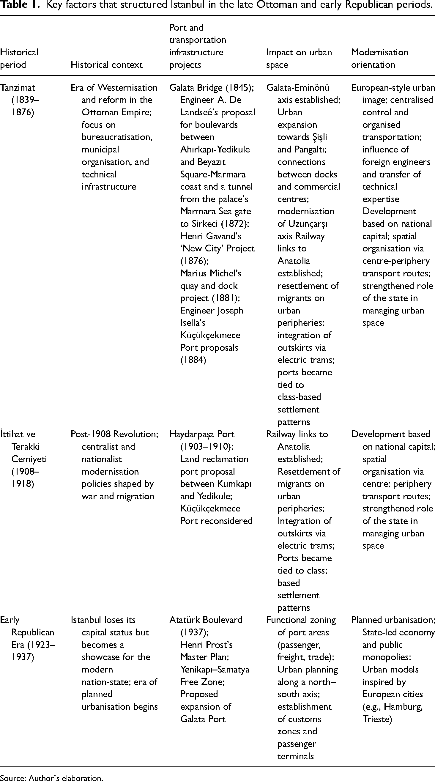
Source: Author's elaboration.
During the modernisation process that began with the Tanzimat and extended to the proclamation of the Republic, a series of projects were prepared in Istanbul, covering port infrastructure and transportation networks, though only some were implemented. Nevertheless, urban development continued along the axes defined by the unimplemented port projects.
Footnotes
Funding
The author received no financial support for the research, authorship, and/or publication of this article.
Archives
Başbakanlık Cumhuriyet Arşivi [Prime Minister's Office Republic Archives], Ankara. Başbakanlık Osmanlı Arşivi [Prime Ministry Ottoman Archives], Istanbul, Yıldız Resmi Maruzat [Yıldız Palace Official Submissions]. İstanbul Büyükşehir Belediyesi Atatürk Kitaplığı [İstanbul Metropolitan Municipality Atatürk Library]), Istanbul. Istanbul SALT Research Centre, Istanbul.