
Abstract
This article assesses how urban segregation and ethnic diversity in Stockholm have been shaped by spatial policy and migration trajectories over time. Much of the urban studies and planning literature defines segregation as a measure of residential mixing. In contrast, our research suggests that segregation could be understood as a lack of opportunities for interaction in public space. In the case of Stockholm, space syntax network analysis and the establishment of ethnicity as a statistical category suggest that despite the social infrastructure provided by the Swedish state, the city’s specific spatial configuration alongside its policies of housing allocation have resulted in severe constraints on the potential for co-presence between new immigrants and the native Swedish population. Spatial analysis suggests that the city’s public transport infrastructure is a contributory factor in maintaining separation between foreign-born and ethnic Swedes. Coupled with a high level of social deprivation amongst new immigrants, the result is a multi-dimensional spatial segregation process that persists amongst the second immigrant generation, reinforcing ethnic and socio-economic area-based housing segregation. We conclude that despite Sweden’s long-standing political vision of social integration, its capital is suffering from increasing ethnic spatial differentiation, which will most likely persist unless a greater consideration of spatial connectivity and an introduction of ethnic and racial equality data in policy and practice are brought to bear.
Introduction
This article focuses on research into the political, spatial and social factors shaping urban ethnic segregation in Stockholm. We describe a paradoxical situation, whereby Sweden, internationally renowned as ‘the model of a tolerant, egalitarian, multicultural welfare state’ (Schierup and Ålund, 2011: 45) with a long history of social equality and economic and political justice (Pred, 1997), has a markedly high rate of ethnic residential segregation, with barriers to overcoming this segregation through mobility and co-presence across the city. The Swedish state has shaped policies regarding housing allocation, which have been quite successful in achieving positive social outcomes in the context of a mostly homogeneous nation.
Yet in more recent years, with the arrival of a large number of migrants and refugees mostly from post-conflict zones in Africa and the Middle East, major cities such as Stockholm have undergone a dramatic shift in their demographic patterns. Sweden is, in fact, one of the North Atlantic societies that has most immigrants and inhabitants of ‘foreign background’ in its population (Schierup and Ålund, 2011: 46). While the same principles of equity in treatment remain, ethnicity is not part of the housing allocation process due to the lack of formal ethnic and racial statistics (Håkansson Bolve et al., 2017). The result is, given the lack of available public housing in central districts, immigrants find themselves living in relatively remote spatially segregated suburban areas, in largely non-native Swedish clusters (Andersson, 1999; Andersson et al., 2010).
This article aims to investigate the extent to which the spatial configuration of the city – coupled with its mass-transit metro infrastructure and changing housing market – shapes access to education and opportunities for work as well as the potential for interaction between the city’s ethnic minority population and ethnic Swedes. This research builds on previous work which has discussed how spatial configuration can contribute to physical co-presence between different ethnic groups in general (Urry, 2002; Valentine, 2008) and in Sweden in particular (Legeby, 2010, 2013).
In the following sections we provide a theoretical background to the subject of enquiry. This is followed by a brief introduction to the case and its policy context. Following a description of the methods employed in the empirical study, the main bulk of the article is dedicated to presenting the spatial and demographic analysis of the city of Stockholm. 1 The article ends with conclusions and further thoughts on the possible policy interventions that the results of our research could give rise to.
Defining urban segregation and diversity
Defining urban segregation is not an easy task and is regarded as ‘a multi-dimensional process requiring a multi-disciplinary approach’ (Vaughan and Arbaci, 2011: 128). Similar to past critiques of the focus on area-based housing segregation (Musterd and Ostendorf, 2014) and the spatial reduction of segregation to the social division of space (Netto, 2016), we propose that there is a need to construct a more flexible, mobility-based nomenclature of segregation.
Studies of urban segregation cover a wide spectrum of theoretical and conceptual approaches, ranging from the effects of contemporary processes of globalisation on social inequalities in cities and the injustices of state-led spatial planning and housing policies, to how migration and ethnicity affect the long-term conditions of spatial and social segregation in cities (Musterd, 1998; Schönwälder, 2007). Despite the apparent benefits of ethnic clustering beyond the first generation in sustaining community ties and rules of endogamy in certain populations, it is frequently seen as problematic. There is evidence that longer-term minority clustering coupled with structural challenges in housing and planning policy can have a negative effect on factors such as social mobility or access to work (Musterd et al., 2008). Arguably the location of such clusters (namely whether they are close to centres of social or work activity) is another critical factor in shaping opportunities for immigrants to overcome social and economic segregation.
Residential diversity has become in recent times a central topic of concern for planning policy and practice, as well as for urban theory in general (Fincher and Iveson, 2008: 2), with the premise being that heterogeneity is a public good. It stems from a long tradition of segregation studies, which have sought to measure ethnic diversity and residential segregation through statistical indicators, such as indices of dissimilarity and isolation, which compute quite simplistic black/white differences, based on where people live. The narrow focus of such studies has been frequently criticised (Phillips, 2007), whilst a lack of understanding of the ultimate aims of urban segregation policies continues to hamper debate. For example, if spatial segregation is bad, where is the evidence that integration – or residential mixing – is necessarily good? In this article we suggest that a more varied consideration of the ethnic, cultural, religious and national background of migrant communities and individuals is needed to better understand the position of minorities in contemporary society.
Conceptions of diversity and co-presence in Sweden
It is important to bear in mind the specificity of the Swedish policy context. The Swedish social democratic government established the welfare state ‘folkhemmet’ (‘people’s home’) in the 1930s (Legeby, 2010: 31). The goal was to create an equal classless society, an approach regarded as the ‘middle-way’ between socialism and capitalism. To achieve this result, subsequent social democratic governments, who dominated Swedish politics for most of the 20th century, went on to create a comprehensive public housing policy system, which constituted a housing solution for most of Swedish society well into the 1970s (Andersson and Turner, 2014). Importantly, the Swedish system differed from the more selective social housing policy mechanisms more common throughout much of Western Europe (Schönwälder, 2007).
Swedish official demographic data does not record ethnicity (Håkansson Bolve et al., 2017). Instead it refers to all citizens with a foreign background as ‘immigrants’. This definition includes all those born abroad or with two parents born outside of Sweden. The presumption is that once an individual has settled in the country, their ethnic origins cease to be accounted for in housing allocation. While the reasoning for this stems from a social-democratic approach to equality, it can result in a lack of consideration of the needs of people from specific ethnic, cultural or religious backgrounds (Håkansson Bolve et al., 2017).
The policy stems from a desire to focus on socio-economic inequality with no direct consideration of ethnic background (Andersson, 1999). The result is a conceptual dichotomy, which, as Barinaga (2010) has pointed out, results in an over-emphasis on ‘the difference between the national and the foreigner, the Swede and the immigrant, us and them’ (Barinaga, 2010: 199).
According to Esping-Anderson’s (2013 [1990]) welfare state typology, Sweden has been a model social democratic country. It is frequently cited along with the other Nordic countries for its high living standards, and has been regarded internationally as an ‘ideal type’ with a well-managed governance system and public sector (Righard et al., 2015). One central aspect of Sweden’s urban development has been the political social welfare system, and its strong government control over planning and building and a national goal of making social services easily accessible (Cars and Harsman, 2001: 87).
For Sweden, the post-war years were a time of urgent need for mass scale housing, which led to the government’s ambitious ‘Million Homes Programme’, a national housing scheme to build one million new homes between 1965 and 1974, mainly in new self-contained modernist urban developments in the outer suburbs of the larger cities (Hall and Vidén, 2005: 301). This programme was economically based and resulted in a wide range of building typologies, including detached housing. However, it was dominated and mainly known by its large scale modernistic neighbourhoods. These followed a Neighbourhood Unit type of layout, which typically results in inward-looking local centres, which suffer from poor city-wide connections (Karimi and Vaughan, 2014).
Figure 1 shows the location of some of the larger Million Homes Programme areas in Stockholm’s urban periphery. It overlays this on a map which is coloured according to the proportion of minorities in each geographical area, using data from 2015. 2 It presents a picture of how past decisions on allocating housing to new immigrants – according to where public housing is available – have resulted in immigrant populations being disproportionately located in the urban periphery. Notably, the economic situation of these areas is markedly poorer than average for the city (Stockholm Municipality, 2016). This map is the starting point of our analysis: to investigate whether the spatial pattern and the planning and public transport infrastructure of the city are a contributory factor in its social segregation between immigrants and minorities and native Swedish people.
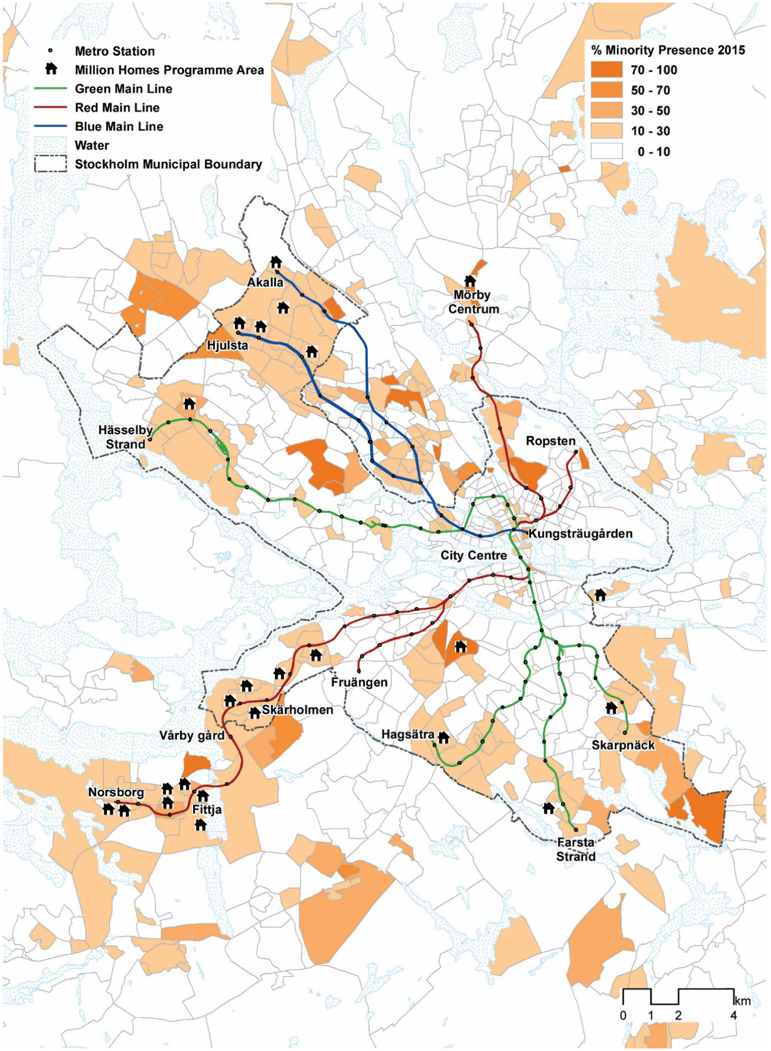
Stockholm’s prominent ethnic clusters, metro network and Million Homes Programme areas.
The growing ethnic divide is further illustrated in two recent studies revealing the scope of urban unrest in the margins of Sweden’s larger metropolitan areas. Schierup and Ålund (2011) analysed the connection between educational opportunities, ethnicity, class and gender – distinguishing Stockholm’s centre from its multi-ethnic periphery (Schierup and Ålund, 2011: 52). In a quantitative analysis of urban unrest, specifically looking at the location of car burnings, Malmberg et al. (2013: 1044) found a statistically significant correlation between loci of urban unrest and ‘racial’ 3 residential segregation in Swedish cities.
It is important also to consider the spatial dimension of segregation and diversity. In urban studies, diversity is normally considered to be a simple matter of mixing of classes of use or of people, with little account for the spatial interrelationships between the individual elements counted. Previous research into co-presence in Swedish cities has argued that neighbourhoods that do not afford mixing between immigrant and native populations ‘may be left in the shadow of information and knowledge that potentially can contribute [to] overcoming social exclusion’ (Legeby et al., 2015: 108:4). Mixing in public space provides opportunities to experience and recognise people from other backgrounds; to create everyday encounters (Franzén, 2009; Valentine, 2008).
With the growth of the digital economy, the role of face-to-face, spatially-based exchange in furthering economic (and indeed social or cultural) exchange is recognised as necessary for overcoming fear and for building trust (Phillips, 2010). Given that social activity takes place at multiple scales and times across the city, urban research today is increasingly focused on bridging across multiple spatial factors – street networks, urban form, land use diversity – and their connection to social change over time, as well as physical and ‘virtual’ forms of communication (Andersson and Musterd, 2010). Nevertheless, the literature on daily encounters in public space tends to be divided on whether this translates into meaningful face-to-face interaction or if it remains superficially at the level of familiarity.
Whether it leads to interaction or not, recent research in Swedish cities has shown that public space can play a key role in the matter of segregation (Legeby, 2013; Legeby et al., 2015). Central public spaces create heterogeneous co-presences since they attract movement from diverse parts of the city, ‘facilitating good conditions for exchange in these co-presences of difference, whether it is exchange of a social, economic or informational kind’ (Sarraf, 2015: 97). One central question is how exchanges between different ethnic groups might be realised in cities that are residentially segregated across ethnic, social and economic lines. As we have argued elsewhere in the case of Jerusalem, the essential factor in overcoming segregation is for individuals to move through public space to create opportunities for interaction with other groups (Rokem and Vaughan, 2017). Thus, the spatial layout of cities is paramount to their functioning and success, especially in the urban periphery. This has been shown to be the case in London (Vaughan et al., 2010), for example; however, as argued by Legeby (2013; Legeby et al., 2015) and supported by our neighbourhood scale spatial analysis of Stockholm’s street network (see Figure 2), it is evidently not the case in Stockholm.
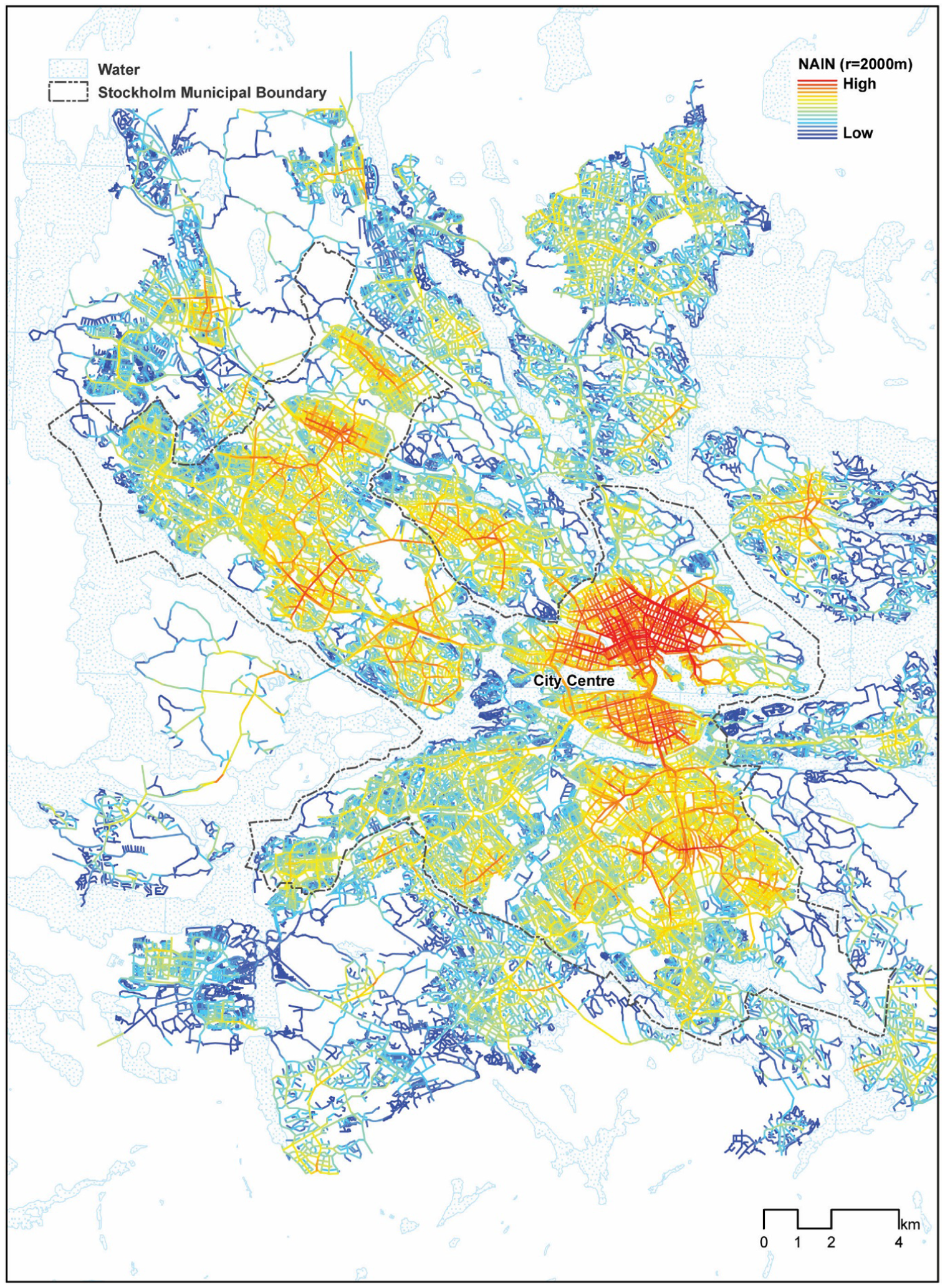
Space Syntax analysis of Stockholm’s spatial structure, showing Normalised Choice (NACH) 2000 metres (the colour range from red to blue indicates high to low values.
Immobility, or being trapped within one’s neighbourhood, constitutes one of the main causes of social exclusion (Massey, 1994). We propose that mapping the potential for mobility and interaction allows for a view of segregation as more multifarious and complex than the dominant focus on residential patterns – suggesting urban segregation to be simultaneously a political, social, economic, ethnic and racial artefact of an individual’s mobility in the city. Segregation alone is not necessarily a problem and could be viewed simply as spatial congregation, but overcoming a combination of segregation and immobility is an urgent challenge when seeking spatial and social justice.
Background to the case
In recent decades, the ‘Swedish model’ has shown signs of a steady increase in socio-economic inequality. The increase is especially significant when considering statistics at the municipal level, with a widening gap of municipal socio-economic differences. Unlike the situation in Southern Europe and the UK, which have become accustomed to waves of immigration over the years, until the late 1980s, Sweden maintained a relatively low percentage of migration, especially from outside Europe (Pred, 2000).
One example of an effort to tackle segregation in Sweden is the ‘social mix policy’ dating from the 1970s (Holmqvist and Bergsten, 2009), bolstered by more recent policy initiatives to tackle segregation and foster integration through programmes to distribute resources equally and to encourage mixing (Andersson et al., 2010). Since the mid-1990s the list of ‘problem areas’ has been constantly updated and several policy interventions have attempted to target the same marginalised places (Marcus, 2007). Many of the areas targeted by the special government policy initiatives are in Million Homes Programme suburbs built in 1965–1974, with residents from a foreign background mainly housed in multifamily apartment complexes (Andersson et al., 2010).
There is an on-going debate between Swedish policy makers and researchers about the classification of the segregation problem as ‘ethnic’ 4 or ‘socio economic’. Although new immigrants receive a substantial share of public service expenditure, there is a gap in terms of employment opportunities and choice of housing options between ‘ethnic others’ and ‘ethnic Swedes’. Nevertheless, housing policy continues to be based on financial and social criteria rather than ethnicity and cultural heritage (Holmqvist and Bergsten, 2009: 480), and immigrants arriving with a refugee status to Sweden are required to have been resident for at least four years before receiving full citizenship. 5 These barriers to social mobility are reflected in the recent establishment by the current government of an Equality Authority. This new agency was launched in January 2018 with the official task of tackling growing societal divides in Sweden, and for the first time to collect equality data to better map and cater for minority groups’ needs. 6
Housing policy and ethnic exclusion
The Million Homes Programme constitutes as much as 20–25% of today’s Swedish housing stock. Recent research points to evidence that, despite its ambitions, both its physical layout and the housing policies resulted in de facto residential segregation (Legeby, 2010: 14), with most immigrants in the past two decades (many of whom came from African and Asian countries) being allocated dwellings in ‘particularly vulnerable and excluded areas’ (to use some of the governmental policy language), spatially and socially differentiated from the Swedish population (Central Statistics Sweden, 2008). In the first instance it was predominantly labour migrants and working-class Swedes who settled in the newly built areas. This changed with the ‘second wave of migration’ and the arrival of asylum seekers and refugees from conflict zones such as Bosnia and Iraq, who were housed in vacant Million Homes Programme areas, which happened to be amongst the most remotely situated housing areas in the city (Andersson, 1999).
Swedish official analysis of the distribution of housing type by country of origin over the period 1997–2006 (Central Statistics Sweden, 2008: 49) reveals a minimal change in tenure over time for each of the ethnic groups in the country, from Swedish, Nordic and ‘other’ European, to Asian and African. The data shows that while people from a European background have changed tenure, with a move into the private sector, over 80% of African and 60% of the Asian population, mainly ‘refugees and asylum seeking migrants’ according to the report, lived in public rented apartments in the study period. In contrast, the government study shows over 60% of ethnic Swedes living in single-family dwellings and least likely to be living in publicly rented multifamily accommodation. Given the likelihood that these apartments will have been those located at the urban fringes, this provides corroborating evidence that the current spatial differentiation of ethnic groups by tenure and housing location has been a feature of the city for at least a decade. Indeed, as our mapping of geographic location of ‘economic migrants’ and ‘refugee’ countries of origin reveals (see Figure 3), this trend has most likely intensified over time. In the following section, we consider social and spatial aspects of these areas within the Swedish capital’s urban periphery.
Ethnicity. Demography and Spatial Segregation
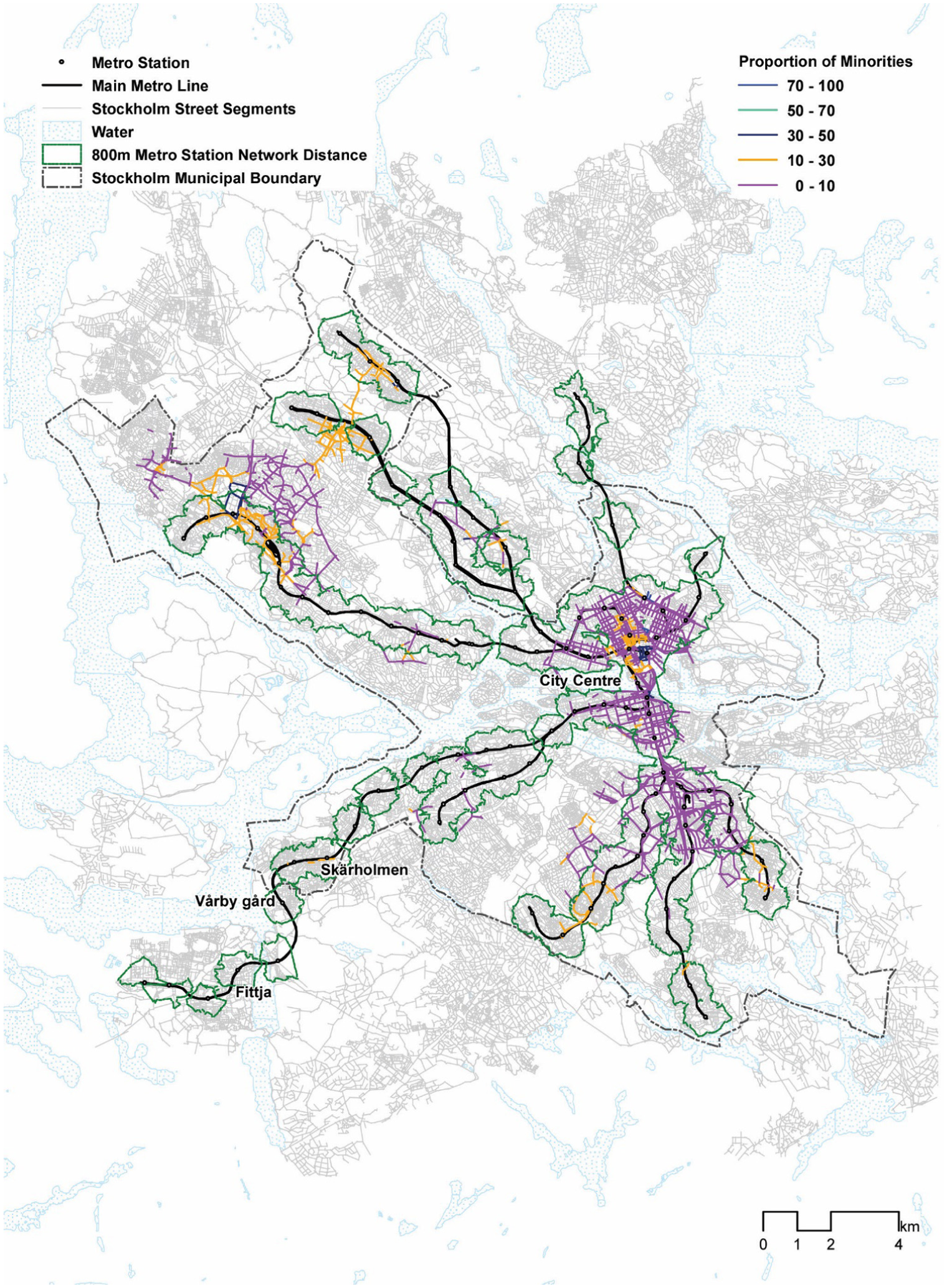
Stockholm’s street network configuration is a result of its geography, with its archipelago landscape as well as its planning resulting in a city comprised of spatially disconnected enclaves (Marcus, 2007: 256). The latest statistics for Stockholm show that the city has a population of 935,619 and a total foreign-born population (including those with two parents born abroad) of 31.5%, with a sharp difference of 20% in the inner-city districts and 38.5% in the outer districts (Stockholm Municipality, 2016). The city’s ethnic segregation is characterised by a concentration of several ethnic groups with a foreign background in a rather small number of districts at the city fringes with relatively high levels of ethnic minority unrest (Malmberg et al., 2013). The clustering of immigrants in specific segregated areas has created neighbourhoods where non-immigrant Swedish citizens rarely visit and, as our spatial analysis shows (Figure 1), the likelihood of passing through, whether by metro or other transport means, becomes highly unlikely.
Until the 1980s the capital of Sweden was essentially homogeneous (although that description is contentious, as there has always been a steady movement of populations within Scandinavia, especially from Finland and other Nordic countries). Sweden has in recent years received one of the greatest numbers of refugees in proportion to its population, second only to Austria and Hungary. Those of foreign origin (first- and second-generation) account for over 20 per cent of Sweden’s total population; of these, more than half are from non-European backgrounds (Schierup and Ålund, 2011: 46) – although in Sweden’s larger cities, the proportion of the population from immigrant backgrounds is considerably higher. In Stockholm the diverse ethnic minority population is predominantly situated in its peripheral suburbs, with high concentrations of people from a variety of non-Swedish, and especially non-European, backgrounds in a small number of spatially segregated locales (see Figures 3a and 3b).
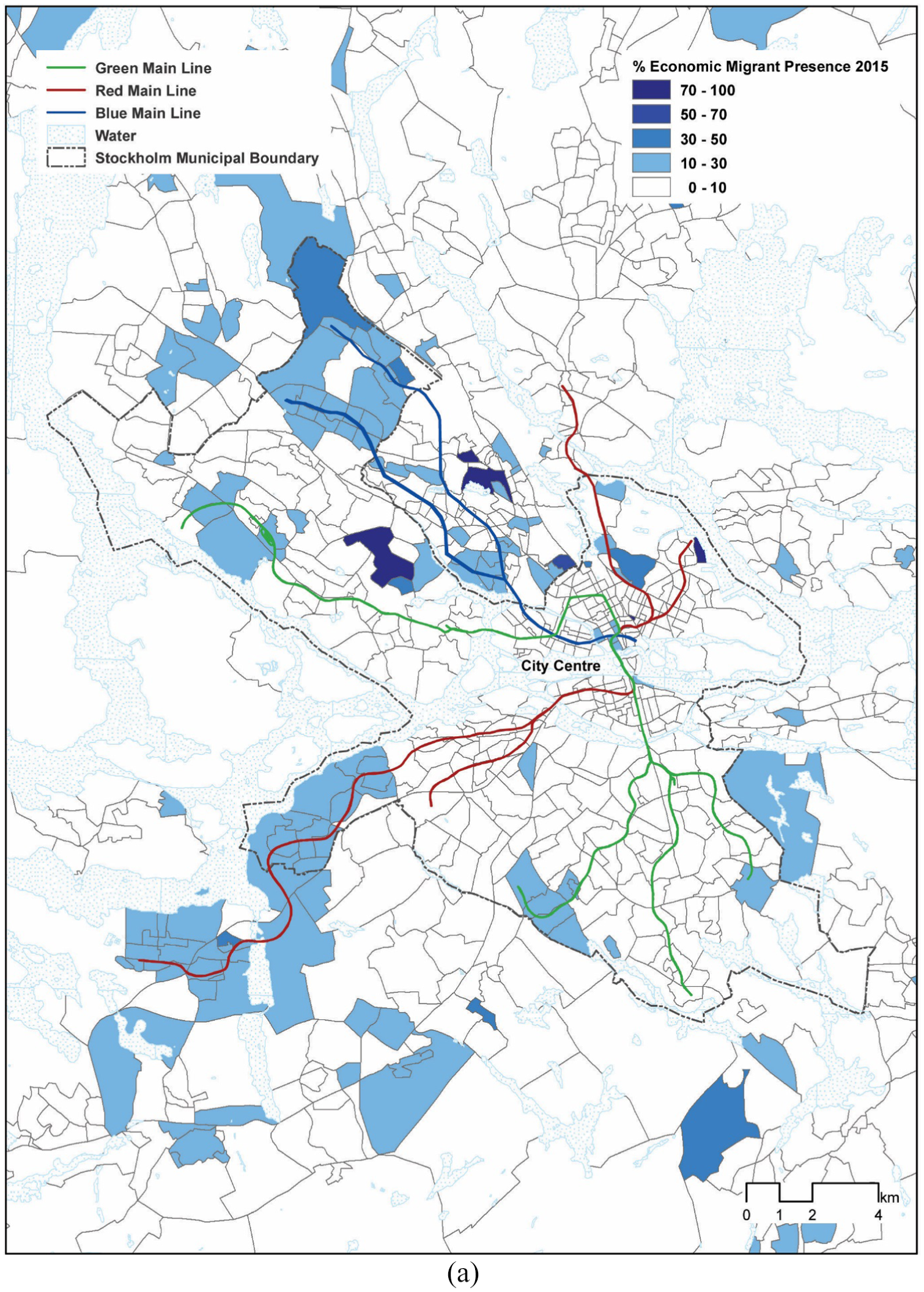
Prominent ethnic clusters of economic migrants.
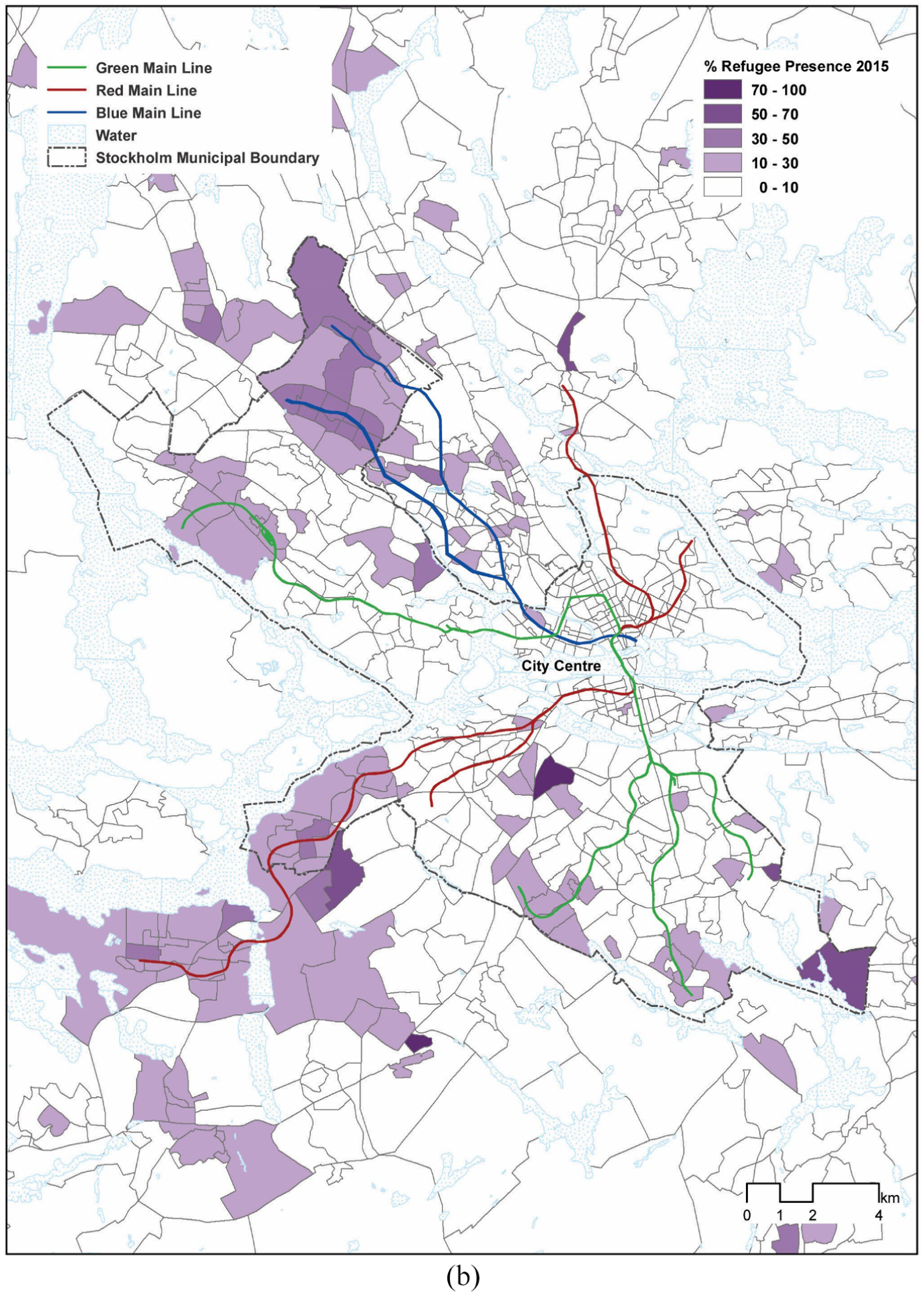
Prominent ethnic clusters of refugees.
Methods
The statistics used in our analysis were taken from the (ODB 7 ) area database, the most detailed and comprehensive database available for the Stockholm County Council Area covering greater Stockholm. The Stockholm Regional Planning Administration, a division of the Stockholm County Council that oversees planning and future growth, manages the ODB database. The database provides detailed statistics for a variety of topics and scales, including national background and spatial location over time. The areas used in our analysis are called ‘base areas’ and are the smallest statistical units available in Sweden. For the purposes of our study, the official statistics record of country of birth served as a substitute for ethnicity.
The theoretical complexity of segregation demands a methodological approach that can handle the many competing factors which shape this socio-spatial aspect of urban life. In this study we have used a combination of space syntax methods, along with detailed demographic data and interviews. The qualitative materials for this research were gathered through a synthesis of fieldwork and interviews (2013: N = 20; 2016: N = 10) conducted with municipal planners and community activists in Stockholm, combined with a range of secondary material including professional reports, planning documents and newspaper articles. Due to the quantitative focus of this article and limited space, the qualitative materials of the research are only mentioned in brief.
Space syntax analysis of street network configuration is an established method for urban analysis that uses graph-mathematical measures of the relative accessibility of the street network to model the potential for movement across urban systems. It stems from a wide body of theoretical and empirical research which has established that, all things being equal, a significant proportion of movement through urban streets is determined by the structure of the grid itself, rather than by specific attractors or generators of activity (Hillier, 1996: Hillier and Iida, 2005). 8
We modelled the pedestrian routes throughout the city of Stockholm by creating a street network geographical information (GIS) model covering the full extent of its built-up area (the street network layout was provided by Dr Ann Legeby from the Royal Institute of Technology, Stockholm). 9 The space syntax method converts the street network into a relational graph and then analyses this using graph theory principles. Detailed GIS data on the metro system and demographic data for 2015 at the local ‘base area’ (the smallest statistical geographic unit available) were provided by Stockholm County Council’s Growth and Regional Planning Department and the Stockholm ODB database.
The spatial model itself covered Greater Stockholm to the widest extents of its built-up area. We used two principal space syntax measures of route accessibility, Choice and Integration, at two scales of analysis, 800 metres and 2000 metres. 10 The two scales approximate a standard 10-minute walking distance and the maximum distance that would be reasonable to walk to public transport, respectively.
Spatial analysis: Segregation, mobility and co-presence in Stockholm
Since the last time we met [in 2012] there is no change with the regeneration of [a peripheral Million Homes Programme neighbourhood in Stockholm] main public spaces. The funding, which was promised by the municipality, has not yet been received. […] The public areas next to the main square and public transport stop have become a place for criminal gang activity and drug dealing by some of the local youth. This is a major concern for residents and the police are involved, but they are not solving the problem. To prevent this deterioration, we need major investment in the local public realm.
11
(Local municipality area development officer, interview, 9 November 2016)
The above quote is taken from an interview conducted with a local area officer to follow up on an interview conducted in 2012. The officer serves in the local authority for one of the suburbs in the urban periphery of Stockholm. Strikingly, the quote highlights the officer’s perception of a lack of investment in the locality. It also points to the view of the periphery as being a place apart from the city centre. Importantly, the interview highlights the on-going perception of there being a process of decline in the built fabric of the area around the metro station, which has contributed to social deterioration. The degradation of the area is apparently the outcome of that lack of government funding and the interviewee suggests that the continuation of allocation of immigrants to the same location is deepening already existing problems.
The following analysis seeks to test whether there is supporting evidence for the perception held by the local officer. It opens with a review of the spatial structure of the city, followed by analysis of the city’s demographics. The way in which ethnic diversity plays out spatially and through accessibility forms the latter part of the analysis.
Ethnic diversity and the geography of difference
Legeby’s (2013) citywide space syntax analysis of Greater Stockholm’s patterns of accessibility finds that while the centre of the city is highly integrated, it is poorly connected with its periphery. This is especially challenging in the swathe of neighbourhoods to the south-west, where a ‘wedge of spatial segregation’ results in a lack of connections between local areas. She also finds that this lack of overlap between citywide and local street networks results in limited job opportunities and economic activity for those living on the city margins.
Figure 2 shows a neighbourhood scale analysis of Stockholm’s street network, modelling space syntax accessibility for every street segment in the city to a distance of 2000 m (the network is coloured in a temperature scale, so that the warmer the colour, the greater the opportunities of movement). Similar to the findings of Legeby’s (2013) analysis of citywide network connectivity, these results show that Stockholm’s urban core is highly centralised, with a very well connected centre, the remainder of the region being comprised of an array of island-like local centres, with the peripheral neighbourhoods having a reduced local centrality. The spatial disconnection both at city and neighbourhood scales raises the question of whether public transport mobility can help overcome social segregation and geographical disconnection. This is analysed further in the following section.
As mentioned above, classic studies of segregation start from a conception of it being a binary measure, with the most extreme cases involving the majority of a single ethnic group living in clusters where they form the majority population. The situation in Stockholm (and in other major Swedish cities) is quite different. The centre is predominantly homogeneous, and consists mostly of the native Swedish-born population. In the suburban fringes there are areas that are socio-economically, ethnically and demographically similar to the inner city. They are usually geographically separate from those areas with a high proportion of immigrants. The latter are highly diverse in their ethnic makeup, and with a lower average income. There are also significant differences in tenure. For example, a high percentage of the African and Asian population of Sweden lives in public housing. There is also a major shift from public rental housing to private ownership over time, but with only a minimal change in the distribution of housing type by country of origin between 1997 and 2006 (Central Statistics Sweden, 2008).
Figures 3a and 3b show the spatial location of Stockholm’s minority population, by taking each local area and calculating the proportion of (a) economic migrants or (b) refugees and asylum seekers. 12 We have divided the data into these two groups to examine whether people from different waves of immigration and countries of origin have differing spatial distributions. Table 1 shows the background detail of this distinction, listing the dominant countries of origin in each of the two groups.
Refugee and asylum seeker vs. economic migrant prominent populations in Greater Stockholm, including only groups with a significant presence at the urban scale, using 5000 people as the threshold accounting for the largest ethnic minority groups.
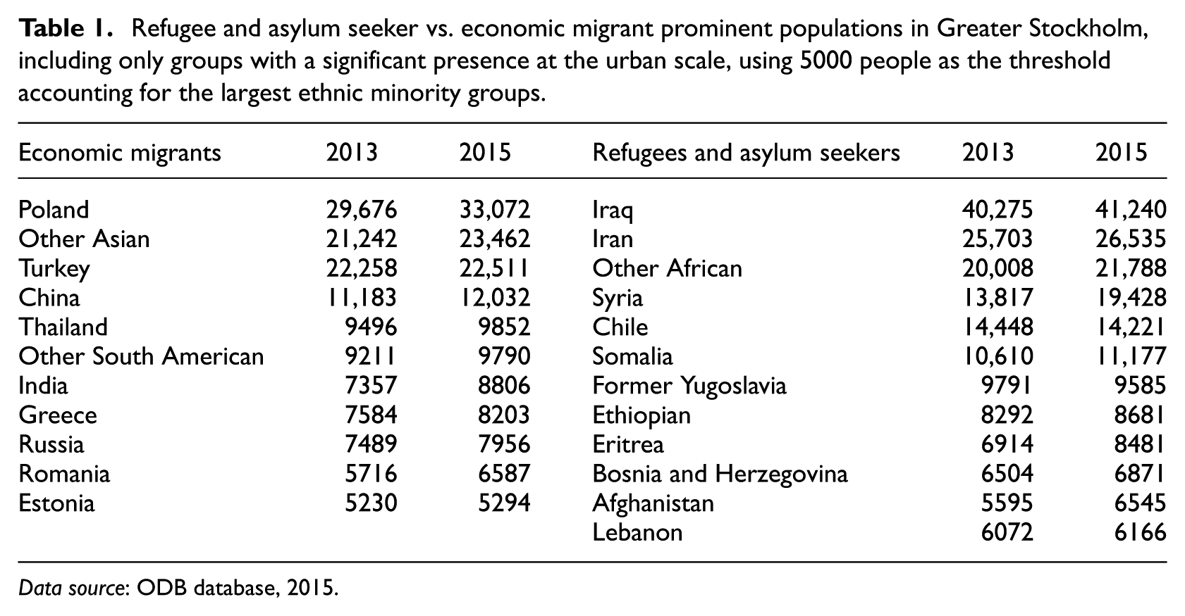
Data source: ODB database, 2015.
Figures 3a and 3b highlight how the two groups have markedly different spatial distributions: there are fewer high density clusters of economic migrants (especially in the outer periphery) than of refugee/asylum seekers (meaning that the latter are less likely to be sharing space with native Swedish people); in addition, economic migrants have a much higher presence in the spatially advantageous areas than do the other minority groups.
The differences may be because most refugees and asylum seekers have arrived in the past two decades, while the economic migrants have mostly arrived from the 1960s onwards and have thus had more opportunities to make preferential moves into the centre. However, there are also underlying processes which have limited the opportunities of more recent migrants to make such moves. These include language barriers and access to employment as well as a limited rental housing market (especially for those without financial means). Nevertheless, the current situation illustrated by Figures 3a and 3b shows that the main railway routes are within the immediate reach of many more areas with a dominant economic migrant presence than those with a dominant refugee and asylum seeker presence.
Opportunities for interaction
The geographical layout of the city of Stockholm, highlighted by the space syntax analysis above (Figure 2), constitutes a disconnected urban fabric with a densely gridded centre, connected via a network of bridges and tunnels to the periphery. For those who have access to cars, or live within reasonable commuting distance, the discontinuity of the urban fabric is not a major obstacle. In contrast, the peripheral suburbs have a relatively sparser provision of public transport, making it difficult to rely on this mode of transport for travel between different Million Homes Programme areas; in addition, the lack of public transport limits opportunities to gain access to the inner city for those who are young, old or unemployed and do not have access to private transport.
Thus, even if the connective tissue of streets and motorways was sufficient, there are few opportunities to commute with ease across the network. Given that most of the refugees and asylum seekers are clustered in the southern and northern periphery (Figure 3b), and given that the spatial analysis highlights that these areas are relatively disconnected from their surroundings (especially in the southern suburbs), the question then posed is whether public transport assists in helping the inhabitants of these peripheral areas in connecting with other parts of the city. This is likely to be especially important, given that statistics show that households in Stockholm’s periphery are very dependent on cars (60% in the outer areas use cars as their first transport mode of choice), yet a correlation between disposable income and household car ownership (based on data from 1999–2008) reveals that the lower income sectors of Swedish society, who are comprised predominantly of immigrants, are much less likely to own a car (Pyddoke and Creutzer, 2014).
The extent to which these key points of encounter between the city’s populations are accessible can be modelled. This is done by considering where there is most likely to be a cross-over between different flows of movement through the city (see original proposition in Hillier et al., 1987, and further testing in Vaughan et al., 2010).
Thus, the premise of the following analysis is to test whether a person’s opportunity to travel to central Stockholm differs according to their ethnic or immigrant status. Figure 4 shows this analysis in a model of how many streets around each of the metro stations are within reach of the city’s immigrant and native populations. It first takes a distance of 800 m from each station and marks it with a green line. It then colours up only those streets which are within the top 5% of accessibility for both integration and choice. The colours used correspond to the proportion of minorities living within the area. So, for example, the streets coloured in purple (0 > 10% minorities) and sitting within blue dotted areas are accessible on foot from any metro station. Going down the scale to those streets with 70% or more minorities, there are only a handful, 37, that are within any reasonable walking distance from a metro station (see Table 2 for a full breakdown). We have not computed travel distance in this analysis, but it is worth noting that the metro only arrives every quarter of an hour or half an hour during the off-peak periods, namely evenings and weekends, and it takes 38 minutes to get to the city’s Central Station from the red line metro’s last stop in Norsborg. 13
The proportion of streets that are highly accessible and within 800m of a metro hardly ever intersect with an area with a high migrant population (of over 30%). See Table 2 for detailed analysis.
Total number of segments within reach of metro stops in each base area, broken down according to the proportion of non-Swedish nationals.
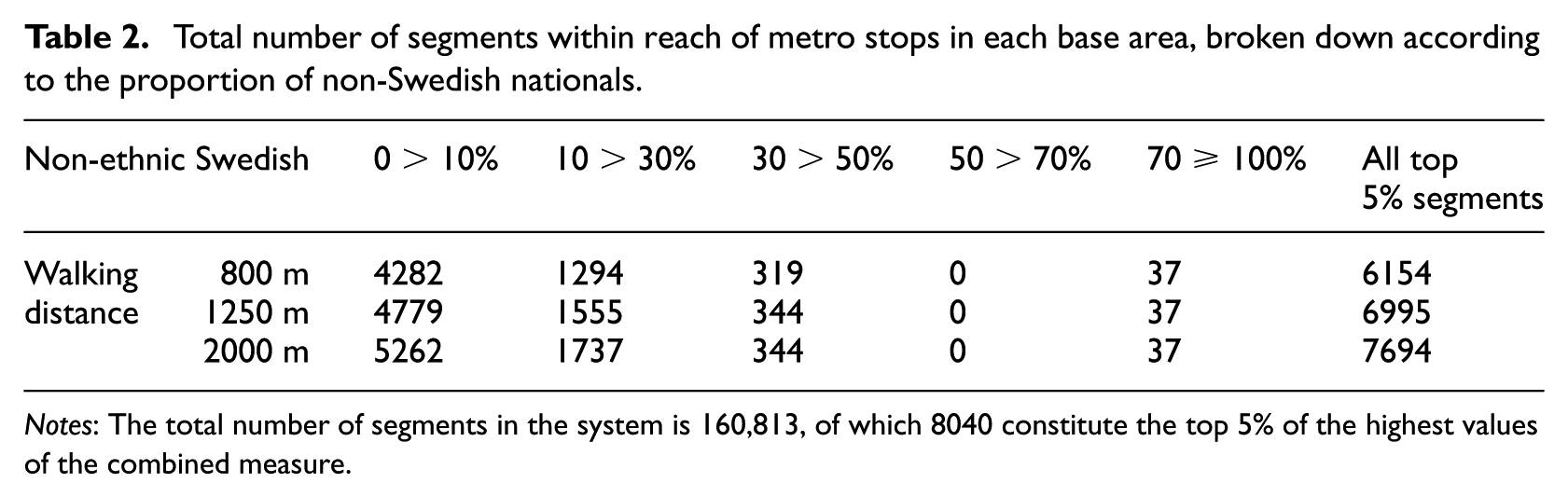
Notes: The total number of segments in the system is 160,813, of which 8040 constitute the top 5% of the highest values of the combined measure.
Figure 4 and Table 2 highlight the fact that areas with high minority presence (50 ≥ 100% non-ethnic Swedish) have negligible access to the metro, and that no more than 0.6% of all high value, accessible segments are within any of the reasonable walking distances – and can be as distant as 2000 m. Even this small amount is, upon closer inspection, part of the university district and likely to be populated by international students, 14 rather than long-term immigrants. In contrast, areas with less than 50% non-Swedish nationals have a large proportion of all the strategically accessible segments across the city.
Conclusions
Greater Stockholm’s inherent spatial fragmentation was manageable for many years, so long as the population was reasonably equal in its social hierarchy. What we have shown in this article is how a series of planning and policy decisions coupled with global events have wrought a situation that arguably could not have been foreseen when the city first expanded in the 1950s. The space syntax analysis has highlighted the fragmented nature of the urban fabric in the city periphery, which, together with modernist planning using the Neighbourhood Unit concept, housing allocation policies and a distributed public transport infrastructure feeding the outer suburbs, has exacerbated social and economic separation between incomers and locals. The analysis has shown that the spatial reach of the city’s archipelago of peripheral neighbourhoods is limited. We have highlighted some of the main reasons for travel and why lack of mobility is critical in reducing opportunities for co-presence and reinforces ethnic segregation. The main challenge is that while most of the everyday basic needs such as schools and local shops can be accessed more locally this does not permit co-presence and potential interaction with the native Swedish population, who as we have pointed out have little reason to visit the remote parts of Stockholm where most immigrants reside. The statistical analysis provides some confirmation of our interpretation that the everyday reality of life in the Stockholm suburbs is one of limited interaction between ethnic minorities and native Swedish people. This is especially evident when the ethnic statistics are broken down into sub-groups of ‘refugees’ and ‘economic migrants’. Given the vulnerability of the refugees, we suggest that they require attention in future Swedish housing policies and planning strategies to ameliorate the effects of spatial segregation on their opportunities for mobility and, consequently, their ability to interact with native Swedes. We have aimed to give a more complex and diverse picture of the spatial distribution and opportunities for mobility of migrants in Sweden, and in Stockholm more specifically. The illustration of the general geographical spread of each of these groups – and especially the predominantly larger presence of economic migrants closer to the centre – is a significant finding that demands further research. The main aim, as we point out above, is to challenge some of the political and policy related arguments about the ‘dense immigrant clusters’, revealing their ethnic diversity and nuanced spatial layout.
Our findings suggest that with current use of socio-economic data in Sweden to allocate and develop public housing and transport policies several factors and local needs are being left out. There are clearly different housing needs for different communities, and for this reason targeting this diversity currently masked as ‘immigrant integration challenges’ in planning and housing policy is precisely one of our main points in this article. We propose that this is a first important and constructive step to inform urban policy about immigrant diversity and its local needs beyond its current practice, to be further developed in future research and impacting decision-making. This holds wider societal relevance for other cities in Europe and further afield that are experiencing similar flows of migration.
Our theoretical review highlighted how segregation needs to be considered as a multivariate problem, entailing spatial as well as social and economic divisions. Paradoxically, the demographic composition of Stockholm reveals that the most segregated areas are also the most diverse, and what are considered the most prosperous parts of the city are also the most homogeneous. As such, our analysis demonstrates that a more nuanced understanding of diversity is essential for a thorough consideration of segregation in the contemporary city. The results showing spatial differences between economic migrants and refugees reveal how both the political status as well as the cultural capital of incoming migrants can shape their spatial and socio-economic integration. Our research has shown that the well-meaning Swedish national policy of subsuming all incomers under a single label of ‘ethnic other’ masks a highly complex range of integration trajectories. Our argument for a need to address the socio-spatial complexity of integration in Sweden is substantiated by the recent political debate in the country concerning the need to map ethnicity and race. This debate has led to the launch of a new Swedish government equality authority, 15 which aims to tackle questions similar to those raised in this article.
We have also critiqued the problematic focus on residential segregation more generally in the urban studies literature and also within policy and practice in Sweden. Our analysis of opportunities for interaction showed that there is an almost binary difference between Swedish areas and minority areas, with the latter highly disadvantaged from the point of view of access to the spatial core of the city. Given the complexity of segregation in Stockholm, this situation is unlikely to be solved simply by knitting the urban fabric together. Nor are area-based policies effective on their own, as our local informant pointed out in the quote above. We believe that only a root and branch rethinking of the use of ethnicity in statistical data, exemplified by the spatial analysis in this article, coupled with housing policies and transport infrastructure accessibility (to include spatial as well as social diversity), can start to ease the situation on the ground.
Footnotes
Acknowledgements
We want to thank the four anonymous reviewers for their helpful comments on earlier versions of this article. We are also very grateful to Professor Lars Marcus from Chalmers Institute of Technology Gothenburg, and Dr Ann Legeby from KTH Royal Institute of Technology, Stockholm, for their invaluable feedback. We would also like to thank Matilda Rehn and Jonas Jernberg from the Stockholm County Council Regional Growth and Planning Administration for all their advice and support with the ODB database, and Bjorn Larsson and Lennart Jansson from the Central Bureau of Statistics Sweden for providing the demographic data on Stockholm. Lastly, we would like to thank Dr Sadaf Sultan Khan who assisted with the conceptual development and design of the maps. syntax/contested-urbanism.
Declaration of conflicting interests
The author(s) declared no potential conflicts of interest with respect to the research, authorship, and/or publication of this article.
Funding
The author(s) disclosed receipt of the following financial support for the research, authorship, and/or publication of this article: The work on this paper was funded by the EU s Horizon 2020 research and innovation programme under the Marie Sklodowska-Curie grant agreement No. 658742 and is part of the outputs of the Contested Urbanism Project. For further information visit: ![]() .
.