
Abstract
Between 1948 and 1971, the Massachusetts Department of Public Works released plans to build a freeway through Cambridge. One route would carve up a working-class neighborhood while another would run alongside MIT. First, we assess the impact of the planning process. While no highway was built, housing stock declined and uncertainly complicated urban renewal. Second, we explore MIT’s role in this story. Because its campus lay near a proposed route, the university functioned much like any other stakeholder. Yet its economic importance and its involvement with federal defense gave its administrators access to arguments unavailable to local residents or politicians. MIT functioned as both agent and subject, as a private entity at the mercy of federal and state prerogatives and as an influential public force in its own right, whose institutional knowledge, national importance, and civic significance overshadowed city and community prerogatives.
In 1948, the Massachusetts Department of Public Works (DPW) released plans to build an eight-lane highway, the Inner Belt, to speed travel to the suburbs and to relieve traffic congestion in Boston’s central core. Both the rationale behind and the routing of the Inner Belt became a target of heated debate: one route considered by DPW, the Brookline-Elm route, would carve up a diverse working-class neighborhood in eastern Cambridge and dislocate thousands; another, the railroad route, would run alongside the campus of the Massachusetts Institute of Technology (MIT) and disrupt scientific research funded in part by federal dollars. By providing local governments with a set of alternatives, highway planners inadvertently pitted one of the nation’s premier private universities against a longstanding community of renters and homeowners.
Although Massachusetts canceled the Inner Belt in 1971 in response to local protest and dwindling national enthusiasm for highway construction, the delay, in and of itself, profoundly affected the Brookline-Elm community. In the twenty-three years of planning for the Inner Belt, residents of the area slated for demolition watched their neighborhood deteriorate, their public school languish, and their own economic security disappear. In this respect, the history of the Inner Belt in Cambridge resembled that of other American cities that grappled with highway construction in the postwar period—but with one key distinction. Unlike in Miami, New Orleans, New York, Washington, D.C., and San Francisco, bulldozers did not level a single home in Cambridge to make way for a freeway.
Historians including Andrew Highsmith and Raymond Mohl, among others, have documented the devastating consequences of freeway construction on postwar American cities. 1 Freeways not only fueled the expansion of shopping plazas, office parks, and cookie-cutter developments, they also served as a means for government planners to eradicate urban blight and to lay claim to central city neighborhoods. From the mid-1950s to the early 1970s, highways transformed the urban landscape, paving over aging or decrepit housing and removing residents by the thousands, a disproportionate number of whom were elderly, poor, or African American. 2
In his study of Flint, Michigan, for example, Highsmith details how a protracted and poorly executed plan to build Interstate 475 and a General Motors industrial park wreaked havoc on the St. John’s neighborhood. From the time city officials released renewal plans, it took them seventeen years to acquire buildings and to reimburse property owners for their losses. All the while, homeowners and businesspeople waited, foregoing renovations and other investments in their neighborhood. By the time they did receive payment, the fair-market value of their property had plummeted. Housing stock deteriorated, businesses vanished, and real estate prices fell, exacerbating segregation and accelerating urban decline. 3
But what happened to communities when freeway construction never occurred? The story of the Inner Belt in Cambridge offers an opportunity to expand our thinking about the consequences of urban renewal policy in general and highway planning in particular on central city neighborhoods. Specifically, by combining archival records, oral histories, and newspapers accounts, one can evaluate how the protracted debate over the Belt affected the community slated to be razed. Because no demolition occurred, it is possible to assess if and how the planning process in and of itself shaped the neighborhood. First, indecision and uncertainty over the route hampered residents’ desire and ability to renovate their properties, resulting in deterioration of the housing stock. Second, it convinced the city school committee to forego renovating the local public school. And finally, it hampered the city’s effort to secure funding for other urban renewal projects, including efforts to improve and to expand public housing.
The history of the Inner Belt also offers a window into the precise, and often problematic, position of universities in urban planning decisions. MIT was but one player among many in the Belt saga; community activists, automobile lobbyists, construction companies, suburban developers, and local, state, and federal officials all had a hand in the controversy. Yet MIT alone assumed several particular—and contradictory—roles. Because its campus lay near the path of a proposed route, MIT functioned much like any other stakeholder, with the right and the responsibility to defend its interests. Yet its considerable importance to the local and state economy and its involvement with federal defense projects also gave its administrators access to arguments unavailable to neighborhood residents or city politicians. Believing that the private university existed to serve the public good—to advance knowledge, to educate students, to aid national defense, and to innovate in science and technology—administrators refused to permit a highway to demolish or isolate its campus. In this way, MIT functioned as agent and subject, as a private entity at the mercy of federal and state prerogatives and as an influential public force in its own right, whose institutional knowledge, national importance, and civic significance overshadowed city and community prerogatives.
Like other urban universities, MIT became a major player in the city’s economic development during a national period of urban decline. Its relationship to Cambridge thus resembled that of many other “Cities of Knowledge,” to borrow a phrase from Margaret Pugh O’Mara. O’Mara outlines a process where urban research universities like MIT sought and received large amounts of federal money from Cold War defense spending and attracted science and technology businesses and white-collar professionals into the city. 4 At the time of the Inner Belt dispute, the Institute was the second largest non-government employer in Cambridge, with some eight thousand people on its payroll. 5 And while it was officially tax-exempt, it made significant in-lieu-of-tax payments on land acquisitions for a twenty-year period. 6 Moreover, MIT’s institutional prestige, derived from its research capacity, also empowered its administrators to invoke national self-interest to influence decision making at the local level.
In some respects, MIT’s involvement with the Inner Belt thus confirms much of what historians already know about how research universities functioned in postwar American cities, utilizing their political and economic capital to influence local, state, and federal policies that facilitated their expansion into urban neighborhoods. O’Mara documents how administrators at the University of Pennsylvania lobbied for and capitalized on the federal Section 112 program, a 1959 amendment to the Federal Housing Act that incentivized campus expansion into central cities. 7 Likewise, Michael Carriere details how Columbia University deployed Cold War rhetoric and stoked fears over urban decay to facilitate its growth into Morningside Heights. 8 Similarly, Marisela Gomez paints a devastating portrayal of how Johns Hopkins Medical Institution benefitted from a drawn-out and ill-defined urban renewal process that aided its encroachment into Middle East Baltimore. 9
But while urban research universities like MIT, Columbia, Hopkins, and Penn shared a common enthusiasm for federal urban renewal policies that facilitated campus expansion, their stance on a particular form of urban renewal—freeway construction—appears more idiosyncratic. Examples of university involvement with urban expressways suggest that individual prerogatives tended to inform institutional actions. At the University of Chicago, for instance, LaDale Winling describes how administrators courted an expressway in an effort to cordon the campus off from its segregated and impoverished surroundings. 10 University of Chicago officials, he notes, sought out a highway south of campus in order to create a barrier between Hyde Park and the declining Woodlawn neighborhood, which was growing more impoverished and more African American. 11 On the other hand, administrators at the Rochester Institute of Technology (RIT) responded to pressure from the New York Department of Public Works to direct the state thruway alongside its campus not by welcoming the road, but rather by relocating the university to the suburbs. 12 Conversely, officials in search of a site for the new University of Illinois Chicago Circle Campus sought proximity to a highway not to barricade the campus from the community, but to facilitate commuter students’ travel to and from school. 13
It is also clear that not all urban universities carried equivalent influence with highway planning officials. Perhaps the most tragic example of university involvement with freeway location conflicts occurred in Nashville, Tennessee. Benjamin Houston recounts how in the mid-1950s, the routing of Interstate 40 inexplicably shifted away from prestigious Vanderbilt University and onto the backsides of three historically black institutions, Fisk University, Meharry Medical College, and Tennessee State University. 14 Fisk professors led the anti-freeway effort, lobbying the mayor, the governor, and numerous federal officials. But their efforts did little to dissuade highway builders from laying ribbons of asphalt between the campuses of TSU and Fisk and Meharry. It is no exaggeration to say that I-40 devastated North Nashville’s African American community; a single two-and-a-half-mile road leveled one hundred square blocks, taking with it 650 homes, 27 apartment buildings, and effectively bankrupting much of the independent black-owned business in the city. 15
In the case of the Inner Belt, MIT administrators did not, like their counterparts at the University of Chicago, court a highway to protect their campus from a declining community. Like UIC officials, they did look favorably on an expressway because it would shorten travel times to the suburbs for faculty and staff and enhance connections with the technology-park-laden Route 128, but at no time did they express a desire to create a commuter university. In contrast to their counterparts at RIT, MIT administrators made no effort to relocate their campus, nor did they have any reason to do so, given that no highway materialized. And as was the case at Fisk and TSU, MIT faculty members with expertise in urban issues led the charge against the expressway, though they did so against the wishes of their university.
These brief comparisons suggest that no single response encapsulates urban university attitudes toward freeways. At MIT, administrators opposed a freeway routing that would demolish existing facilities and hinder future research initiatives. While understandable, this stance also made the Institute the enemy to some of its faculty who interpreted such a position as privileging its individual interest over that of the community. Seeing MIT as one of the few entities powerful enough to block the Belt, they understood administrators’ decision to not speak out against the Belt as tantamount to lobbying for its completion.
MIT’s involvement with the Inner Belt thus adds another layer to historical and contemporary conversations about the relationship between institutions of higher education and privilege. More often than not, discussions about universities and inequality tend to be grounded in debates over access—over who obtains entry and who is denied, and over the racial and socio-economic structures beyond the Ivory Tower that delineate opportunity. 16 But universities’ physical engagement with place, the way in which they define and shape the urban landscape, as well as a neighborhood’s economy and its demography, also functions as another lever of inequality. More often than not, when administrators at large urban research universities like MIT flexed their political muscles, they did so to promote policies that complemented their interests. In this way, universities did not differ much from other distinctly private entities like mortgage lenders, realtors, and real estate developers. But because universities could invoke their public function in order to appeal to state and national powers, they could, at times, be even more influential players. The debate over the Inner Belt thus reveals the tensions between institutional, national, and local concerns, tensions some faculty sought to negotiate. In so doing, it also speaks to the growing political power of urban universities that stemmed, in part, from their ability to defend institutional prerogatives with appeals to civic priorities. Finally, it exposes just how influential a university could be, even when the social costs of its engagement did not include physical destruction.
***
To understand how this process played out with regard to the Inner Belt, it is helpful to know a bit more about the history of the project. The idea for a belt originated in 1948 when the DPW issued a Boston-area master highway plan. The proposal included a multilane loop route (Interstate Route 695) that would connect Boston with the adjacent cities of Cambridge, Somerville, and Brookline. By serving cross-town traffic, the Belt would, in theory, ameliorate congestion in Metropolitan Boston. 17 Planners made little progress until 1956, when President Dwight Eisenhower signed the National Interstate and Defense Highway Act in response to national enthusiasm for the automobile and a desire to improve evacuation routes in the event of a nuclear attack. To encourage states to undertake highway projects, the act authorized the federal government to pay 90 percent of highway construction costs. 18
In response to this opportunity for federal funding, in 1957 the Massachusetts DPW recommended a route for the Inner Belt popularly referred to as Brookline-Elm. The proposed highway would traverse Brookline Street, cross Massachusetts Avenue near the Central Square commercial district, and continue along Elm Street. Along the way, it would pass through three densely populated neighborhoods: Cambridgeport, Area Four, and Wellington-Harrington, collectively referred to as Brookline-Elm (see Figure 1). 19 DPW officials championed this route by asserting that it would enhance local economic development. By locating the highway just east of Central Square, they would direct it through areas identified for urban renewal, similar to the national trend that Mohl describes. Highway boosters, including construction mogul and soon-to-be Massachusetts governor John Volpe, also anticipated that the “considerable blighted property in the area . . . would reduce the costs of right-of-way acquisition,” thereby lessening the burden on taxpayers. 20
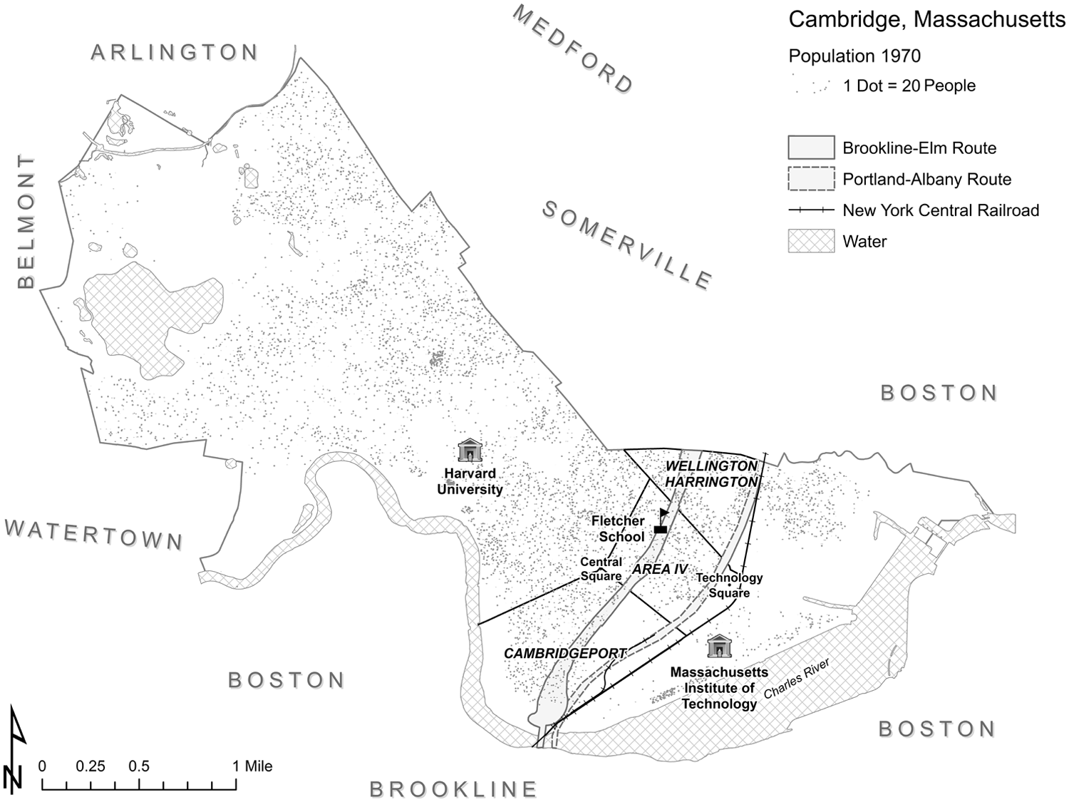
Map of Cambridge and proposed Inner Belt alternatives.
In 1958, a year after the DPW recommended the Brookline-Elm route, the Cambridge City Council asked the Cambridge Planning Board to consider two other possibilities, one following Memorial Drive along the Charles River and the other that would run along the tracks of the New York Central Railroad. 21 Composed of five private citizens appointed by the City Manager, the Planning Board counseled the city on issues relating to physical development. 22 In the mid-1950s, several members had close ties to area universities, including MIT. Board chairman Ferdinand L. Rousseve had graduated from the Institute with a BA in Architecture in 1930. 23 Board member Pietro Belluschi became Dean of its School of Architecture and Planning in 1950. 24 And board member Frederick Johnstone Adams chaired its department of city and regional planning from 1944 to 1957. 25
After some reflection, in 1958 the Planning Board also endorsed the Brookline-Elm route, appreciating that it would send the highway “directly through blighted and deteriorated areas in need of urban renewal.” 26 Such a location, they anticipated, would “trigger the economic redevelopment of the eastern end of the city.” Board members expected the freeway to displace between two and three thousand residents and considered such costs to be “drastic” but “not excessive.” 27 Soon after, two other prominent civic organizations, the Cambridge Chamber of Commerce and the Citizens Advisory Committee for Cambridge also endorsed the Inner Belt project, anticipating the freeway would help the city attract industry and compete with Route 128. 28
While suburban commuters, businesspeople, and taxpayers stood to benefit from the Brookline-Elm route, those who lived and worked along the route had a great deal to lose. The highway would displace some 1,200 families, nearly 5 percent of the city’s population, and more than one hundred businesses, many of which were small and family oriented. 29 In the mid-1960s, Barbara Brandt, a sociologist studying the Brookline-Elm neighborhood, summed up the community this way: “The 7,000 or so people to be displaced if the B-E route goes through are mainly working class and lower-middle class—that is, next to non-white Americans, they are the most badly screwed by this society, the people who in desperation looked to [George] Wallace, bitterly resent long-haired students and welfare-recipients.” 30 Predominately white and working-class, the neighborhood in the path of the Brookline-Elm route also contained a disproportionate number of poor, elderly, and nonwhite residents (see Figure 2). While Cambridge’s nonwhite population as of 1960 was just 4.4 percent, for example, it was 9.6 percent in the path of the proposed Inner Belt, and had increased to 21 percent by 1970. 31 With a median income of just $6,186, many residents qualified for federal antipoverty aid. 32 One in six was sixty years of age or older. 33 Renters, on average, paid just twenty-seven dollars a month, significantly less than the citywide average of forty-three dollars. 34
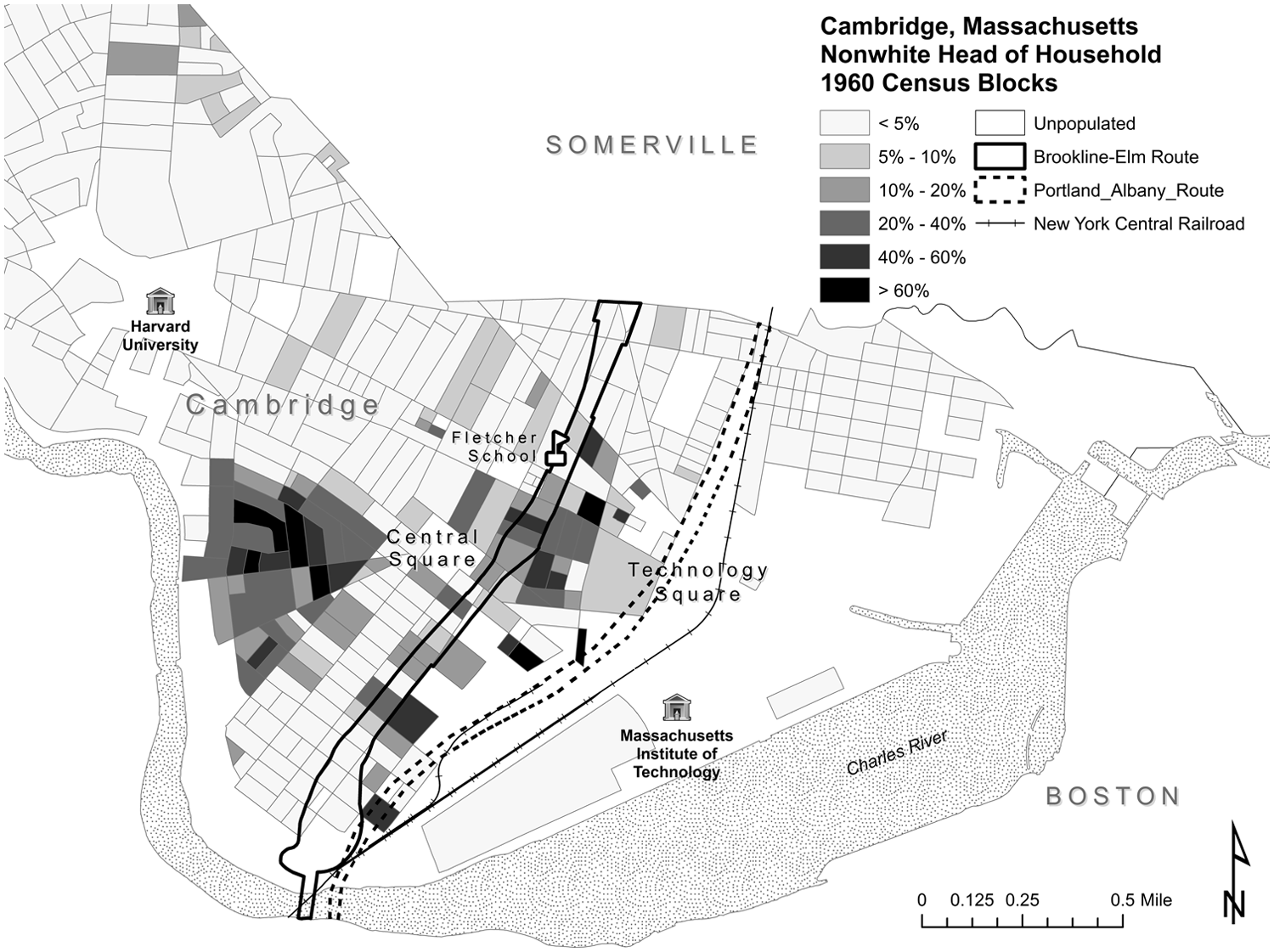
Nonwhite households and the Inner Belt
With no agreement in sight, the Planning Board conducted additional impact studies, all of which reinforced its decision to support the Brookline-Elm route. At the same time, some local officials began to question if the city could withstand any highway. In 1958, Cambridge mayor Thomas McNamara and three city council members, Joseph DeGuglielmo, Charles Watson, and Alfred Vellucci, denounced the Planning Board’s recommendation. 35 As the process dragged on, residents, businesspeople, and city officials complained that the delay itself caused material injury. “‘I wish they’d either shoot us or give us a reprieve,” avowed one shopkeeper in 1959 whose business sat in the path of the proposed highway. He expressed reluctance to repair his store in the event that it would be “wiped out” by the Inner Belt. 36 The Boston Globe dubbed the area in the path of the proposed route “The Belt of Indecision” and described the effects of the proposal on the housing market: “Real estate deals are off-again, on-again affairs,” it reported. “Homeowners hesitate to lift a hammer for repairs.” 37 Vellucci protested that indecision over the routing of the freeway stymied the city’s ability “to plan intelligently its own future capital improvement program” and created a disincentive for property-owners and businesspeople to invest in their community. “Homeowners and businessmen in the entire eastern half of the city are confused as to whether to improve their properties, whether to buy or sell, or whether their properties will be wiped out by one of the nine proposed highway routes,” he complained. 38 In 1959, the Cambridge Redevelopment Authority informed the City Council that the city risked losing millions in federal funding for other urban renewal projects if the uncertainty continued. 39
Further contributing to the delay, residents themselves stepped up resistance to the Brookline-Elm route. In May 1960, in a public hearing organized by DPW, more than 2,500 individuals attended a “jam-packed” meeting at the city high school. Speakers denounced the proposal and called for an alternative. Herbert Edwards, pastor of the Union Baptist Church, declared that the current routing put “material values ahead of human values.” Should the highway be built, it would “leave many of us heart-broken and homeless,” he predicted. Vellucci, a longstanding opponent of university expansion, made his preference clear: “I would rather transplant M.I.T. than 700 Cambridge families.” 40
The following year, in 1961, local politicians convinced the state legislature to give the city the power to veto any proposed route for the Inner Belt. 41 The veto comforted homeowners fearful of losing their property to the freeway and enticed others to purchase property in the area. Brookline-Elm resident Anstis Benfield acknowledged that the veto power influenced her decision to buy a home on Chestnut Street even though it lay in the path of the proposed route: “We were reassured that we would never be taken,” she remembered. 42
While the veto brought some relief to residents and businesspeople, particularly those who lived and worked in the Brookline-Elm neighborhood, it discomfited MIT, which feared selection of the railroad route (Figure 3). When one considers the considerable toll this alignment would have on MIT’s academic activities, its uneasiness becomes understandable. Should a freeway be built on this route, it would run alongside the university’s northwestern edge, stranding part of the campus on the other side. The road would also eliminate several expensive and specialized research facilities. Moreover, rather than being a barrier against declining neighborhoods, it would instead restrict MIT’s ability to expand, sandwiching the campus between the freeway and the Charles River. In August 1965, Assistant City Manager and Cambridge Planning Board member Harold Myer observed that the railroad route would “interfere” with “MIT’s plans to eventually expand into or over the [railroad] right of way.” Likewise, Harvard University administrator Charles Whitlock also sympathized with MIT’s position, acknowledging that “the Belt would split up MIT; even overpasses and underpasses cannot unify a campus adequately.” 45
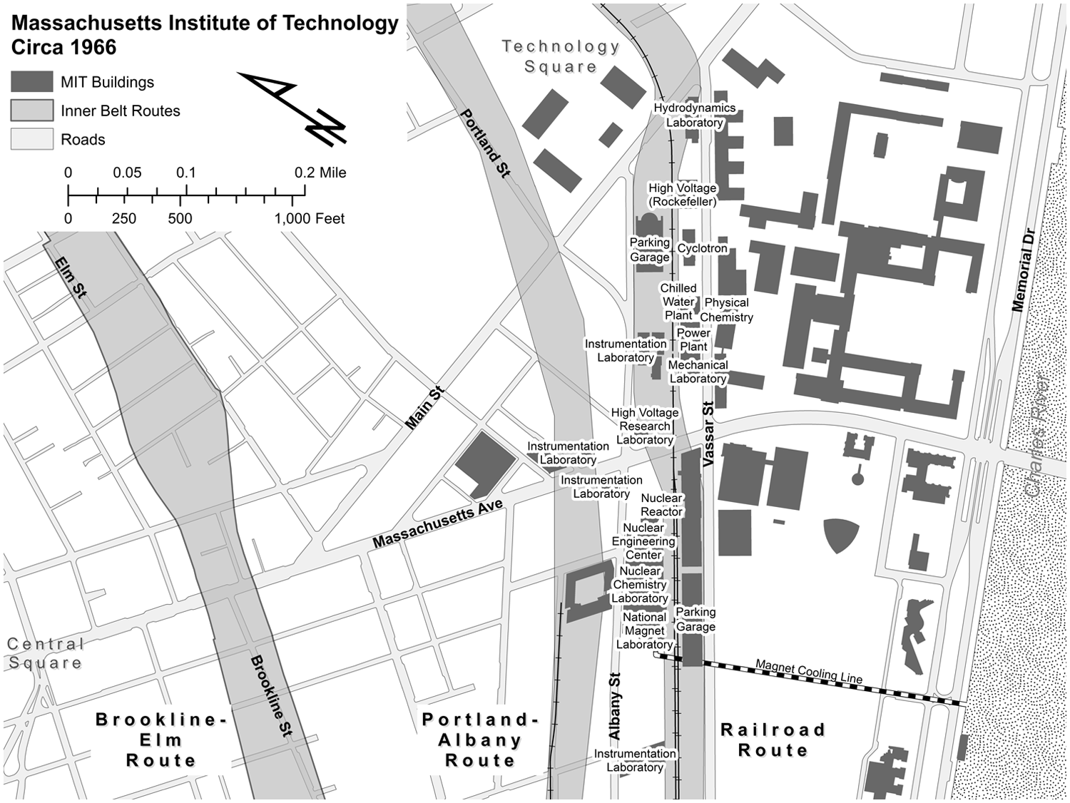
The geographic relationship of MIT to the proposed Inner Belt routes, Technology Square, Central Square, and the Charles River, circa 1966.
Beginning in 1962, the administration undertook a series of indirect efforts to insert its voice into the planning process. First, it relayed a willingness to the DPW to muster its intellectual resources to assist with highway planning. 46 Second, it assigned university administrators to connect with state officials involved with belt planning. 47 And finally, while MIT officials did not publicly enter the Inner Belt debate until 1966, they may have expressed doubts about the project privately years before. According to Cambridge State Representative John Toomey, MIT administrators lobbied for Brookline-Elm and against the railroad route as early as 1959. Toomey maintained that MIT’s President Julius M. Stratton had told him “the Inner Belt would never be built along the railroad tracks flanking the MIT campus because, ‘we have enough influence to stop it.’” Stratton flatly denied Toomey’s charges: “I have no hard and fast position on the Inner Belt and have no desire to stop it,” he contended. “[As] to dictating where the Inner Belt would go, this is simply not true. . . . We are in no position to do that nor would we take such a position under any circumstance.” 48 In the same statement, however, he did stress Cambridge and MIT’s symbiotic relationship, highlighting MIT’s economic contributions to the city. 49
In addition to suspecting that MIT administrators had attempted to lobby state and federal officials, community members also believed the Institute had purchased property along the railroad route in an effort to thrust the highway into Brookline-Elm. In 1961, the Harvard Crimson reported on the “considerable opposition” to the railroad route emerging from MIT. Not only did its “nuclear reactor” lie “in the path of the road,” but the route would “also split off some of the new land that Tech has been acquiring and developing in the area.” 50 Here, the Crimson referred to a parcel MIT had recently acquired that came to be known as Technology Square, a purchase some saw as a direct attempt to block the railroad route. 51 Similarly, in 1964, when the DPW began to seriously consider this alignment, MIT began negotiations with the New York Central Railroad Company and eventually purchased an additional block-long section of the railroad property adjacent to its campus. When news broke of this acquisition, MIT officials similarly insisted that the Inner Belt had not factored into their decision. 52
Regardless of whether or not MIT purchased land defensively, it is clear that highway planners were reassuring administrators that the DPW was unlikely to select the railroad route. In March 1964, MIT administrator Frank Colcord reported to Stratton that James Fitzgerald, the State Commissioner of Public Works, and John Hansen, the Chief Engineer of the Boston Regional Office of the Federal Bureau of Public Roads (BPR) had “made it very clear . . . that they were strongly opposed to the route running along the railroad” and “seemed to feel that the only feasible route in Cambridge is something in the general area of the recommended Brookline-Elm route.” 53 Likewise, in August 1964, MIT alumnus and chairman of the Massachusetts Bay Transportation Authority James McCormack informed Stratton and Corporation Chairman James Killian that “MIT could stop worrying about the chance of the Inner Belt being located along” the railroad or Memorial Drive because “he was in receipt of a letter from the U.S. Bureau of Public Roads declaring that neither of these solutions would be acceptable as a basis for federal aid in the construction of the roadway.” 54 Killian’s reply to McCormack, thanking him for the information, suggests MIT officials probably were communicating the university’s position to state highway planners. 55
Despite its early success, the anti-Belt movement soon experienced a series of setbacks, beginning with the gubernatorial election in November 1964 of construction company owner John Volpe. A former head of the DPW and administrator in the Federal Highway Administration, Volpe was a vocal and enthusiastic proponent of highway construction in general and the Belt in particular. 56 Not long after his installation, in August 1965, the state legislature revoked the veto, again making Cambridge vulnerable to decision making at the state and federal level. 57 Brookline-Elm residents felt the effects of this decision immediately. Benfield observed, “once Cambridge lost the veto power, the housing market crashed—you couldn’t sell a house if you wanted to.” 58 While no evidence suggests that MIT administrators had a hand in this decision, politicians nonetheless underscored the university’s considerable importance in the decision-making process. In November 1965, Cambridge’s Congressional Representative Thomas P. “Tip” O’Neill Jr. explained to sociology professor and community activist Gordon Fellman that MIT possessed tremendous power. While O’Neill himself favored a route along the Charles River, he thought that MIT’s opposition made such a selection unlikely. “[A]s long as [Stratton] remains President of MIT, it will have enormous influence with the federal government,” O’Neill conveyed to Fellman. “He has unimaginably influential access to top people, unlimited influence. He has connections all the way to the top.” 59
When the Inner Belt threat rematerialized, residents began to organize in response, collecting petitions and staging a protest on the steps of city hall. 60 Concerned homeowners like Benfield, a young mother of two, and William Ackerly, who resided on Lopez Street, formed the United Effort to Save Our Cities (SOC) with help from pastors whose parishes lay within the Brookline-Elm route. SOC held regular meetings to raise awareness about the highway and published numerous editorials decrying the social costs of the Belt. 61
SOC members also appealed to MIT administrators. 62 Benfield and her associates believed that in order to block the Brookline-Elm route, SOC needed to persuade the Institute to halt its opposition to the alternatives. In October 1965, she asked Stratton “whether or not a Railroad route would be possible” from the Institute’s point of view. She acknowledged that “some versions of the DPW Railroad route would be very disadvantageous for MIT” yet she hoped the university might reconsider its position in light of the devastation the freeway would bring to the people of Brookline-Elm. 63 Years later, she recalled the rationale behind her appeal. “We were never trying to stop” the Belt, she explained. “We were trying to move it off the residents and over to the railroad . . . but by shoving the whole thing over to the railroad right of way, that would’ve been in MIT’s backyard . . . of course MIT wasn’t big into that.” 64
While SOC made little headway with MIT’s administration, it did succeed in soliciting help from some faculty. As was the trend nationally, academics with expertise in urban issues began to question highway construction policies decimating central city neighborhoods. 65 They were also experimenting with advocacy planning, a movement that sought to empower low-income residents with technical knowledge. 66 As an offshoot of that interest, a small number of faculty helped launch two nonprofit organizations central in the anti-belt movement that provided free technical assistance to opponents of the freeway, including residents of Brookline-Elm, in an effort to help them understand, evaluate, and engage with the planning process. 67
In September 1965, a small cohort of professionals and urban planners, who were in their words, “concerned with the highway problem for both civic and professional reasons,” set out to devise an alternative routing that would do “the least possible harm to the physical, economic, and social welfare of the city.” 68 Composed of Fellman, MIT professor of urban planning and architecture Robert Goodman, city planner Chester Hartman, urban designer Denis Blackett, and MIT professor and architect Tunney Lee, among others, the group first called itself the Cambridge Committee on the Inner Belt (CCIB) and later renamed itself Urban Planning Aid (UPA). 69 According to Fellman, they were influenced by the nascent advocacy planning movement, which “meant professionals in various disciplines getting together and offering their skills to low-income neighborhoods that needed political and planning help, and couldn’t afford to do it [or to] buy it.” 70 Advocacy planners believed the complex nature of urban politics disadvantaged individuals with less education and technical literacy. By providing no-cost technical assistance to low-income communities, they could make the planning process more democratic and therefore more equitable. 71
Like SOC, CCIB, and its successor organization, UPA published editorials and appealed to local, state, and federal officials. 72 But most critically, the CCIB and UPA utilized members’ professional expertise to devise an alternate alignment. In November 1965, they suggested a location slightly to the west of the railroad route along Portland Street and Albany Street (see Figure 1). 73 This route came with a lower social cost than Brookline-Elm. While the Brookline-Elm route would displace 1,200 families, the Portland-Albany route would displace approximately 150 families; similarly, the railroad route would displace just 141. 74
Yet even though this route did not bisect MIT, as the railroad route would have done, Portland-Albany nonetheless troubled Institute officials, particularly its former president and current Corporation chairman, James R. Killian. Given his decades-long efforts to increase federal investment in scientific research and the years he had devoted to building up MIT’s research facilities, Killian’s unwillingness to foreclose future expansion possibilities comes as no surprise. As a senior science advisor to President Dwight D. Eisenhower in the late 1950s, Killian had long championed efforts to utilize America’s scientific ingenuity to shore up national defense. To Killian, MIT’s research capabilities advanced both institutional and national priorities. Thus while the CCIB’s proposed routing still directed the highway several blocks away from the university, it nonetheless proved unacceptable because it threatened MIT’s ability to expand. 75 Killian explained his objection to the new routing to CCIB member Goodman: “[Portland-Albany] does not sufficiently alleviate the damage to M.I.T. to enable us to agree that it is a satisfactory solution. . . . [W]e still believe that any alignment along the railroad will result in disastrous damage to MIT.” Killian also declined CCIB’s invitation to assist with efforts to devise a more acceptable alternative, again highlighting MIT’s disinterested position: “[I]t would be an invasion of the responsibilities of the state for an institution such as MIT to volunteer a route proposal of our own—the more so since we are one of the institutions that might be affected,” he affirmed. 76
In response to rising local support for the Portland-Albany alignment, MIT’s administrators became more proactive in their efforts to divert the Belt from campus. They queried scientists involved with federal research projects, explaining the potential danger of the road, and asking them to detail the “detrimental effects” it would have on their work. 77 Laboratory heads replied with lengthy descriptions of the disruption that would result from land taking, demolition, and environmental and noise pollution. 78 “Devastation would not be limited to buildings and equipment,” one such assessment reported: “As many as 1,500 employees might be directly affected if the buildings in which they work were destroyed or adjoined by one of the proposed routes. Hundreds more rely on those facilities although their offices and laboratories are elsewhere on the campus. These land takings would cripple MIT’s educational program, but research projects of national and world-wide importance would also be retarded or completely halted.” Indeed, it noted, “The Institute has expressed its strong opposition and will continue to do all it can to resist proposed Inner Belt routes that would demolish or seriously impair so much of the north campus area.” 79
In December 1965, Brookline-Elm residents received a modest boost when a private consulting firm hired by the city, Barton-Aschman Associates, endorsed Portland-Albany. Barton-Aschman preferred Portland-Albany in part because it came with a lower social cost. While Brookline-Elm would “displace an estimated 1,500 families and 3,000 jobs,” it predicted, Portland-Albany would “displace some 150 families and 180 to 200 jobs.” 80 But the firm also acknowledged that it had not considered how Portland-Albany would affect MIT. 81
Fearing that the city would endorse the Portland-Albany alignment, MIT officials finally took a public stance on the Inner Belt in 1966. One city official described this new public relations strategy as “using an atom bomb to crush a mosquito.” 82 The state had instructed Cambridge officials to propose an alternative to the DPW by March 1, 1966, as the DPW was set to make a final routing decision in mid-March. On February 20, 1966, Killian held a two-hour press conference responding to the Barton-Aschman report. He announced that “[MIT] has no choice but to oppose with all vigor at its command the Inner Belt highway recommended by Barton-Aschman Associates to the Cambridge City Council or similar routes which have been proposed involving the railroad tracks or M.I.T. property in areas north of the railroad.” In a lengthy statement, he reminded his audience of the nearly $2 million in accumulated in-lieu-of-tax payments, the millions of dollars of indirect revenue, and the numerous employment opportunities MIT contributed to the city. In so doing, Killian highlighted the interdependency between Cambridge and its research universities by asserting that the city itself would feel repercussions from the damage incurred by MIT. 83
From the next argument he advanced, it is clear Killian also sought a national audience. He detailed several research projects taking place in MIT laboratories—work that would be disrupted should the DPW select Portland-Albany or the railroad route and took care to highlight the risks such a routing posed to the nation’s well-being and security. The High Voltage Research Laboratory, Killian pointed out, “is a center for the treatment of cancer by electron and x-ray radiation.” It offered “techniques of treatment” available “nowhere else in the world.” The Hydrodynamics Laboratory studied pollution that threatened the water supply in cities nationwide. Most importantly, he asserted, to slow scientific research at MIT would be to jeopardize national security. At the Instrumentation Laboratory, he observed, “some 2,000 scientists, engineers, technicians and others” were hard at work on key defense projects, including the Polaris, Thor, and Titan missiles. Should the Inner Belt proceed along either Portland-Albany or the railroad route, MIT would not be the only injured party. Such an alignment, Killian noted, would “have reverberations far beyond this city and community.” “Indeed,” he predicted, it would harm “educational and research programs serving the nation and the free world.” 84
That evening, MIT dispatched attorney Edward B. Hanify to articulate the university’s position to the Cambridge City Council. Like Killian, Hanify highlighted the severe consequences to the nation should the Belt pass near MIT. With this formulation, he redefined the debate over the proposed highway as a Cold War struggle between communism and democracy. Like Killian, Hanify also held nothing back. “MIT is in the front rank of the forces of Science dedicated to the essential research which the government of the United States considers indispensable to the national defense,” he began. “It is a scientific arsenal of democracy.” “From its halls and laboratories come the knowledge and technique, the brainpower and the resources which contribute to our national survival in an era where the laboratories and technicians of our enemies work sleeplessly to out-distance us in the race to harness the latent secrets of nature as tools of their supremacy.” To Hanify, the choice was easy. MIT had no desire to harm the community. But its responsibility reached beyond the prerogatives of the city and its residents:
We all know that we live in times of mortal peril, always on the brink of devastation by those Communist powers that seek to crush us by moving ahead of us in scientific techniques. These nations seek the perfection of intricate devices, weaponry, missiles and air power. In this way they confidently expect that they will gain the mastery of space, the domination of the tides and the conquest of the atmosphere. The laboratories and research facilities which this so-called recommended route will destroy or cripple constitute a primary scientific arsenal of democracy in this grueling struggle to maintain the balance of scientific power in the service of free man.
85
Constructing the contest over the Inner Belt as a proxy war in the struggle against communism, Hanify redefined the choice between MIT and the Brookline-Elm neighborhood as nothing less than a choice between America and the Soviet Union. In this way, he reframed what was, in essence, a local dispute over urban development into a choice between the nation and one community.
Despite Hanify’s apocalyptic rhetoric, MIT administrators asserted that they had made no effort to dictate where to build the Belt. Instead, they sought only to inform decision makers and the public of the damage that MIT and, by extension, those who benefited from the knowledge it produced, would incur from the Belt. In this way, such rhetoric contained an inherent contradiction. On the one hand, administrators constructed the university as a private, disinterested party, whose responsibilities were distinct from those of the government. “Whether there should be an Inner Belt through Cambridge or where it should go is a matter to be decided by the State and Federal authorities,” Killian maintained. Yet at the same time, university officials cloaked MIT’s importance in the language of American longevity. These were difficult arguments to dispute, particularly in an age when Cold War concerns crept into so many corners of the national consciousness. 86
As MIT’s administration denounced both the railroad route and the Portland-Albany alignment, Brookline-Elm residents also became more pointed in their attacks. Not surprisingly, in March 1966 the DPW again selected the Brookline-Elm route as the best alignment for the Inner Belt, citing substantially lower costs and fewer lost jobs, and submitted its plans for federal approval. 87 Local opponents continued to campaign against the highway, receiving the support of Edward McCormack, who was running against Volpe for the governorship that November. Feeling political pressure, Volpe ordered yet another study. 88
In November 1966, a small group of mothers including Benfield staged a sit-in outside the offices of the MIT President and its Corporation. With toddlers in tow, the women held up signs calling for MIT to help “Save Our City” and “Stop the Belt.” 89 The protestors constructed the fight over the freeway not as a struggle between communism and democracy, but as an epic contest nonetheless. Moreover, they too appealed to MIT’s sense of public mission when they called for it to withdraw its opposition to alternate alignments. “For centuries the rich and powerful have felt it is their right to survive and enjoy life at the expense of the weak,” they maintained. “It is the responsibility of these powerful agencies to protect not only themselves, but the people of Cambridge and Somerville who are too weak and poor to protect themselves from the destruction of the Inner Belt.” They implored MIT to use its considerable resources to help block “the road altogether and push for better public transportation” or “to produce a more humane route.” 90 By invoking the university’s civic responsibilities, protestors appropriated the very rhetoric MIT’s administrators had employed when lobbying against the railroad route.
Despite such appeals, Killian again declined to oppose the highway, thus fueling faculty and community frustration over MIT’s unwillingness to agitate against the project. In a letter to protestor Louisa R. Alger in November 1966, he affirmed MIT’s commitment to its neighbors. He acknowledged urban universities’ responsibility to peaceably co-exist with local communities. He agreed that the Belt debate had strained town-gown relations. Still, he maintained that MIT had never “tried to force the selection” of the Brookline-Elm route, despite what community members suspected. To do so, he explained, “would surely be improper” as it would “place MIT, a private institution, in the position of weighing the interests and concerns of its neighbors and of choosing among them. This is clearly the responsibility of government.” 91
At the time Killian wrote to Alger, however, administrators were privately developing a plan to block the Portland-Albany alignment. In August 1966, four months before Killian replied to Alger, his aide Walter L. Milne counseled him and other senior officials on how the university could “quietly” maneuver against this route. “My own view,” Milne reported, “is, very simply, that it is just not good for M.I.T. to have that road in its backyard and that we should, therefore, resist Portland-Albany with great vigor and determination.” He cautioned, however, that administrators needed to proceed carefully so as not to be cast as the “villain” in the dispute. Next, Milne articulated a series of strategies the university could use to avoid attracting public acrimony, many of which capitalized on its intellectual capital, particularly with respect to urban planning. First, Milne advised, MIT should “study quietly” the Brookline-Elm and Portland-Albany routes, “so that ultimately—if it should come to that—we will be prepared to argue for the best possible road from the point of view of the Institute and the city.” Next, he suggested, they should “quietly and forcefully” be prepared to “present our own case against Portland-Albany whenever we need to” to local politicians. Finally, he proposed, “We should perfect our plan for relocation housing.” All the while, the administration should keep “absolute control of the plan without catching off base, and so engendering anger among, the various local groups and interests now concerned with the relocation problem.” 92
According to MIT’s Real Estate Officer, Antony Herrey, MIT began developing a relocation plan for displaced residents at the behest of Governor Volpe. Herrey recalled that “Volpe explained to Killian that he was under a lot of pressure because the Inner Belt controversy was causing a great deal of political unrest” and said “‘you’ve got to help us out here.” According to Herrey, Killian responded by asking MIT to devise “a plan to build new housing near the so called Inner Belt route so that when people were displaced . . . they could move into apartments that MIT would have just finished.” 93 In some respects, such efforts resembled those of the CCIB, which utilized members’ professional expertise to aid the public good. At the same time, however, some aspects of MIT’s involvement with relocation planning seem less transparent. Specifically, Milne advised the administration to keep its activities secret until the BPR publicized its final selection of a route. At the same time, administrators privately shared MIT’s relocation plans with Volpe and other state officials, including DPW Commissioner Edward Ribbs. 94 Thus when Milne advised Killian to conduct a relocation study, he proposed a creative means for MIT to come to the aid of the governor and distressed residents while simultaneously eliminating the most salient objection to this route: residents’ inability to relocate easily or to find suitable housing alternatives. Indeed, in his strategy memo, Milne acknowledged: “I think we all agree that this is the strongest stroke we can make.” 95
As local protest against the expressway increased, MIT’s own students, faculty, and staff also began to express discomfort with the administration’s stance toward the Belt. In August 1966, three campus organizations, the Civil Rights Committee, the City Planning Students for Social Justice, and Students for a Democratic Society (SDS), published an Open Letter to MIT’s new president Howard W. Johnson urging him to “deplore the proposed Brookline Elm route” and “lead us in a rapprochement with a neighborhood that only MIT can save from total and immediate annihilation.” 96 Then, in early October, students picketed Johnson’s inauguration, protesting the university’s refusal to intervene. 97
Soon after, a small number of senior faculty members also spoke out against the administration’s stance. In October 1966, Harvard’s William Nash and MIT’s Kevin Lynch publicly endorsed the Portland-Albany alignment. 98 In light of Lynch’s writings on urban highway construction, his stance toward the Belt project, and even his decision to speak against the interests of his employer, makes sense. In his 1966 essay “Sensuous Criteria for Highway Design,” which he coauthored with Donald Appleyard, Lynch acknowledged the inevitability of conflicts between road-users (those who benefited from highway construction) and “bystanders” (those who bore the brunt of highway construction). Nonetheless, he believed intelligent planning could do much to alleviate that tension. 99 In 1968, he drafted an even more pointed essay provocatively titled “Should We Build More Freeways in the Center City?” Here, Lynch acknowledged that Americans’ reliance on personal vehicles created “continued pressure” to build freeways through urban neighborhoods. And yet, he did not believe “a national disaster” would ensue if America changed course. Suburban sprawl would slow and individuals would rely more upon public transit. But should urban highway construction proceed unchecked, society would pay a “substantial price” in the form of increased noise and air pollution, lost open space, less affordable housing, and rising stress on vulnerable communities. Expressways should not pass through center cities, Lynch contended, until and unless highway planners could provide suitable relocation housing; insulate communities from noise and air pollution; and ensure that residents retained access to vital services. Moreover, those who assumed the burdens of highway construction should receive appropriate compensation. At the same time, Lynch did not believe that urban residents should be empowered to veto expressways, as “the construction serves a public purpose which justifies the loss.” 100
From his scholarship, it is clear Lynch did not oppose urban highways categorically. Because of his reputation for moderation and his considerable standing in the urban planning field, Lynch’s opinion carried weight. Thus, when he helped circulate a petition endorsing the Portland-Albany alignment in April 1967, despite the fact that it might “prove damaging to some M.I.T. facilities,” freeway planners, government officials, and fellow faculty took note. 101 All told, more than five hundred professors signed onto Lynch’s appeal, which called for a “complete restudy” of transportation planning in the Boston area, one which considered both mass transit and highway construction. 102 Signers included several academic heavy-hitters: Daniel Patrick Moynihan, who would later become President Richard Nixon’s special assistant on Urban Affairs; economist John Kenneth Galbraith; and George Kistiakowsky, former science advisor to Dwight Eisenhower. 103
Not all of Lynch’s colleagues, however, shared similar enthusiasm. On April 11, 1967, C. L. Miller, the head of MIT’s department of Civil Engineering conveyed to Dean Gordon S. Brown that he believed his department probably lost its contract with the DPW because of “pressures being brought on MDPW by members of MIT staff fighting the Inner Belt through Cambridge.” 104 A week later, he wrote to Milne, noting that while “difficult to predict the potential impact on DPW of the Lynch/Carr petition . . . it is quite probable that the most bitter fight is still ahead of us.” 105
Despite internal pressure from some of its faculty to denounce the Belt, administrators held fast, continuing to comment only on the routing. Why did they decide not to oppose the freeway altogether, particularly in light of the potential threat it posed? According to Benfield, MIT’s Chief Planning Officer O. Robert Simha had personally conveyed to her MIT’s desire for the Inner Belt and the Brookline-Elm alignment. He “sat in my living room . . . and told us outright that MIT wanted this road, and wanted it where it was, and not any closer to them, not down the railroad.” “[He] was very clear about it,” she recalled. 106 In general, MIT’s stance toward highway construction did not differ much from that of any other urban employer, who appreciated that a highway would enable its white-collar workers to exit the city at the end of the day and take advantage of suburban privileges: open space, single-family homes, a reduced cost of living, and good schools. 107 Moreover, highway construction had been critical to MIT’s expansion in the first half of the twentieth century, as an improved freeway system in the Boston metropolitan area enabled faculty members to commute to and from the suburbs and helped to attract science and technology businesses into the Cambridge area. 108 Improved transportation networks would allow MIT to connect with the many private science and technology firms popping up along the Route 128 corridor. And finally, should this plan be selected, MIT would be free to expand into the area east of Brookline Street, an expansion that would be made even easier by residents vacating the area because of the freeway.
Throughout the controversy, residents also repeatedly accused MIT of capitalizing on the Belt threat by purchasing real estate in the area at a reduced price. In October 1966, Reverend John J. McDevitt of the Blessed Sacrament Church, which lay in the path of the Brookline-Elm route, reported that “MIT [was] buying property in his parish.” In his assessment, “It would seem that there is a sinister motive behind the actions of MIT. It seems as if they want to get themselves all the property between MIT and the Inner Belt, regardless of the misery that this might cause.” 109 He urged homeowners not to “panic” and sell their properties to “real estate sharpies and educational institutions” eager to take advantage. 110
Whether or not MIT administrators took advantage of fears over the freeway to buy up property in the area remains an open question. At the very least, they were aware that real estate speculation was occurring in the Brookline-Elm neighborhood, with profound consequences for residents. In March 1966, MIT’s Relocation Committee detailed the changes in the housing market in the area affected by the Inner Belt, though it made no acknowledgement that the university had played any part in this process. “In a city with a limited supply of housing and limited open land for new construction, these pressures create an increasingly speculative housing market, accompanied by spiraling rents and sales prices. Property owners are understandably tempted to profit from these circumstances,” it observed. “With each such change in ownership,” they continued, “more property shifts into the control of real estate operators interested only in speculative ownership. Rents are raised in response to the market demand, and present tenants are forced to move.” Such a process disproportionately affected the city’s low-income residents. “The low-income family interested in ownership is unable to compete, and the low-income tenant finds himself squeezed out by a market aimed at students and young professional families.” 111
Regardless of MIT’s intentions, it is clear that many community members perceived the university as a danger to neighborhood stability and believed it was not acting in good faith. Barbara Brandt explains that in the 1960s, Harvard and MIT “had been steadily buying up property and encroaching on the local neighborhoods between them.” “In addition to complaining about the planned highway that was supposed to go through their neighborhoods,” local opponents of the Inner Belt “regularly complained that both Harvard and MIT had so much power that these two universities would make sure the highway never went through their territories.” In other words, she observes, “there was already a town-gown conflict involving both Harvard and MIT against the local neighborhood, and residents assumed that the choice of their neighborhood for the highway route was just another example of the universities’ power over their lives.” 112
No more a simple question of engineering, but rather a contest between local concerns and the prerogatives of the university, the freeway continued to provoke heated public discussions and demonstrations, all of which prolonged the decision-making process. In March 1967, MIT’s Vice President Philip Stoddard sent a five-page memo to DPW Commissioner Ribbs delineating the massive damage the Portland-Albany alignment would inflict on MIT. The routing would take at least two large buildings critical to national defense. Vibrations from vehicles speeding alongside surviving buildings would jeopardize research funded by federal agencies including the Air Force, Army, Navy, NASA, and Atomic Energy Commission. 113 Two months later Stoddard again wrote to Ribbs, communicating MIT’s concern with the “uncertainty” surrounding the Portland-Albany route. This time, however, he also assured him of MIT’s “readiness” to help find “sound solutions to the relocation problem.” 114
In May 1967, the DPW selected the Brookline-Elm route for the third time. 115 MIT’s administration then promoted its relocation program to the U.S. Department of Transportation (DOT). That month, Simha traveled to Washington, D.C., to meet with DOT officials Scheffer Lang and Paul Sitton. He reiterated MIT’s official position. It had never “made a public judgment” about “the efficacy of the Master Highway Plan and the Inner Belt in particular, including the selection of the route through Cambridge.” It responded only when “a particular route” threatened the institution. He also stressed MIT’s “public commitment to participate in the solution of relocation housing and development problems.” He noted, however, that MIT had struggled to cultivate community support for the program because it “could be locally construed as a desire to insure the construction of the Inner Belt Highway and the Brookline-Elm Street Route.” 116 The next month, Killian followed up on Simha’s visit by traveling to Washington to discuss MIT’s relocation planning with Housing and Urban Development (HUD) Undersecretary Robert C. Wood, himself a former faculty member of MIT. This meeting had come at Lang’s suggestion. He had advised Simha that MIT should try to gauge HUD’s “willingness” to support its relocation plan. 117 Whether or not administrators altered federal attitudes toward the Belt project during these meetings, it is clear they did keep the lines of communication open. In August 1967, another DOT official, Chick Carroll, informed Simha that Federal Highway Administrator Lloyd K. Bridwell “has indicated that there are no viable alternatives to the Brookline Elm route” and thus he “would not propose another route.” 118
As MIT administrators met with officials at the DOT and HUD, Cambridge residents also lobbied federal representatives. In May 1967, more than seventy adults and children boarded an overnight bus and traveled south to Washington. 119 There they met with Bridwell, Senators Kennedy and Edward Brooke, and Congressman O’Neill. 120 Protestors reiterated the damage the Belt would do to Brookline-Elm residents, many of whom lacked the financial and emotional resources to relocate. To destroy this neighborhood, Reverend Paul J. McManus observed, would be to level an “integrated community” with more than three-hundred non-white families. 121 O’Neill, a Cambridge resident and a longtime opponent of both the Brookline-Elm and Portland-Albany routings, responded by calling for another restudy to answer the question of whether Boston needed an Inner Belt at all. 122
Then, in November 1967, Cambridge Mayor Daniel Hayes formed an Advisory Committee on the Inner Belt, stacked with academic heavyweights with expertise in urban issues, many of whom who had signed Lynch’s appeal. Committee members included Lynch himself, Daniel Patrick Moynihan, William Nash, and Lewis Mumford, among others. 123 The group advised Bridwell that additional planning itself could harm the people of Brookline-Elm. “It is essential,” they implored, “that during the course of the study the communities now threatened by these highways not be allowed to deteriorate through lack of mortgages, insurance protection, public services, and related programs.” 124 Nonetheless, it advised the BPR to conduct another study to determine if Boston might be better served by fewer highways and improved mass transit, similar to the one Lynch had proposed. 125 In February 1968, Bridwell authorized two studies to proceed concurrently. The first, Task A, would determine if Boston needed the freeway; the second, Task B, would utilize engineers, architects, and urban planners to devise the best possible alignment. 126
As experts continued to study the Belt, resistance to urban highway construction intensified across the nation. In November 1967, the Boston Globe, which had long been in favor of the project, reported sympathetically on the growing opposition to the Interstate Highway Program that was “rising in volume and emotion.” It “has sent great rivers of concrete creeping like lava through residential neighborhoods and commercial areas, dislocating families, schools, churches and businesses,” the Globe explained. “Parks have been torn up, historic sites engulfed. [And] because the slums afford the easiest and cheapest corridors, it was the ghetto families that were most often uprooted.” 127 In New Orleans, protestors rejected the Riverfront Expressway, slated to raze the French Quarter. Neighborhood activists in Baltimore, Maryland, Memphis and Nashville, Tennessee and Montgomery, Alabama, similarly denounced plans to steer federally-funded expressways through poor and predominately black neighborhoods. 128 In 1968, the New York Times reported that “the United States Court of Appeals for the District of Columbia” had ordered “a halt to all planning and construction of $182 million worth of bridge and highway construction in the nation’s capital.” 129 Collectively, these protests drew national attention to the immense social costs of urban highway construction and shifted political momentum against freeways and toward integrated transportation plans. 130
Opponents of the Inner Belt then received an unexpected boost when President Nixon appointed Volpe to head the U.S. Department of Transportation, leaving Lieutenant Governor Francis M. Sargent to assume the governorship in January 1969. On the face of it, Sargent’s installation did not suggest an immediate end to the Belt. An alumnus of MIT himself, the moderate Republican had previously served as DPW commissioner when it selected the Brookline-Elm route in 1966. 131 But Sargent also had extensive knowledge of environmental issues, having directed the Federal Outdoor Recreation Resources Review Commission under President Dwight Eisenhower. 132 In early 1970, sensing growing state and federal discomfort with the Inner Belt, Sargent ordered another restudy, appointing MIT political scientist Alan Altshuler to lead the effort. 133 On February 11, 1970, Sargent announced his decision to change course. While serving as DPW Commissioner four years earlier, he explained, almost “everyone was sure highways were the only answer to transportation problems . . . We were wrong.” While not “technically . . . a moratorium on all road-building,” the Boston Globe reported, Sargent’s restudy amounted to “almost to the same thing.” 134 Sargent explained his rationale to current DPW Commissioner Ribbs: “As a former Commissioner” himself, he “knew only too well that we have not in the past honestly asked whether highways are an appropriate response to our urban transportation crisis, and if they are not, what is.” While answering that question might be “expensive” in the short term, “at least in economic and political terms,” he had “resolved to ask [it].” 135 After yet another year of inquiry, Sargent’s restudy team came out against the Inner Belt. Following its recommendation, Sargent canceled the project in December 1971, closing a freeway planning process that had been ongoing since 1948. 136
The Inner Belt story ended as a victory for the residents of Brookline-Elm (Figure 4). But the drawn-out planning process nonetheless affected the community in several ways. Many had delayed home improvements, for fear they would be unable to recoup their investments. Local banks refused renovation loans, believing the looming demolition endangered the equity owners held in their homes. 137 Years of uncertainty took a heavy toll. Maria Soeiro described the loss of her home as “her biggest fear.” “The route has stopped everything—[it has] left me in midair,” she complained. 138 Homeowner Peter Manetas echoed a similar concern. “My spirit is not there to do any more fixing up,” he explained. “I’m not sure I’d want to stay. But what can I do. No one would want to buy such a house or pay for it.” He doubted he would ever recoup his losses and expressed his reluctance to invest any more: “I don’t know if it will be worth doing any more to my house considering I’ll have a super highway plowing through my back yard.” 139
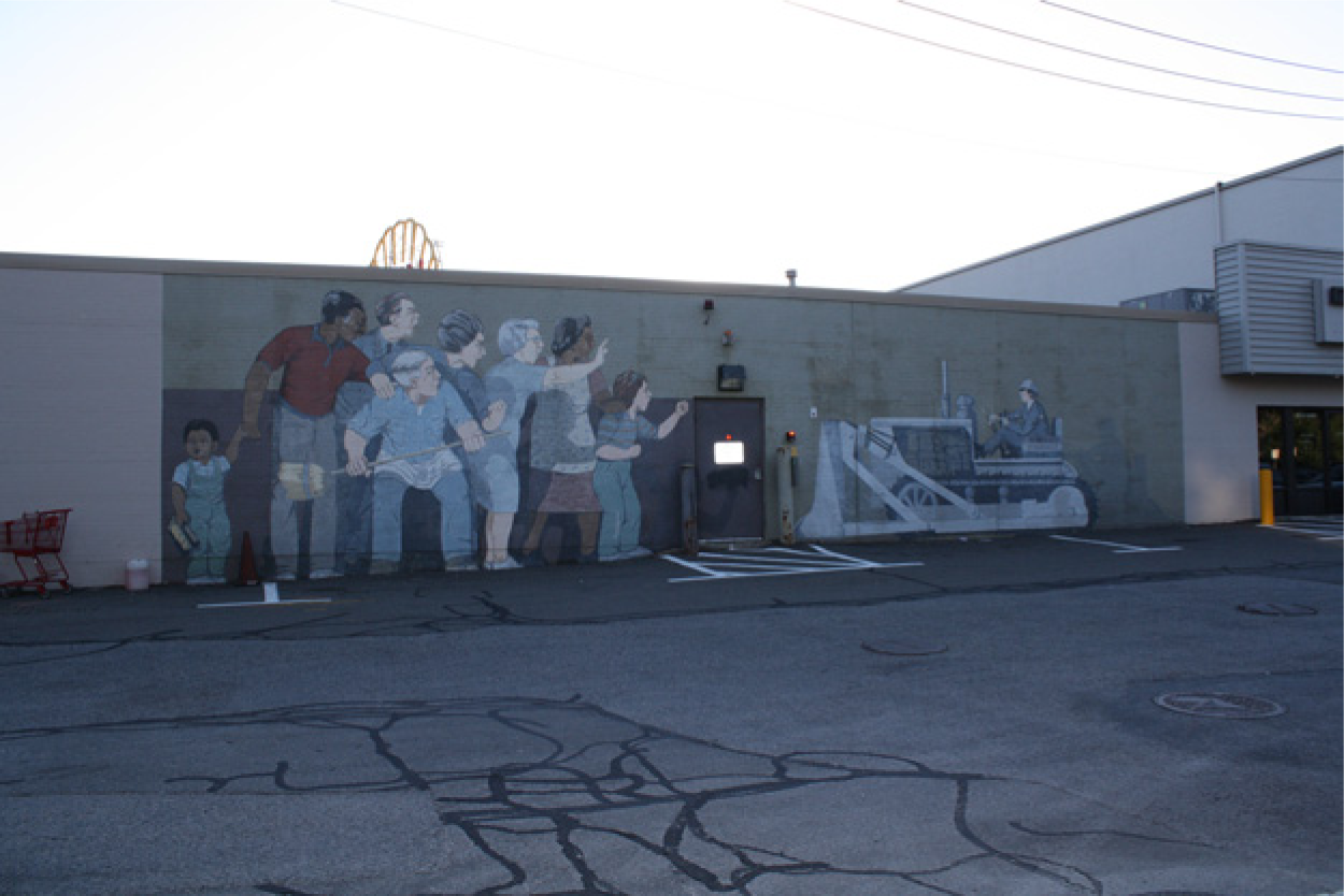
This 1980 mural in southern Cambridge entitled “Beat the Belt” presents the Brookline-Elm community fending off Governor Volpe’s bulldozer.
Doubt over the Belt also caused the city to delay renovating the local public school because it lay in the path of the Brookline-Elm route. By 1960, the Fletcher School, built in 1903, was already in dire need of repairs. 140 While members of the Cambridge School Committee acknowledged that renovating the Fletcher School was a high priority, they determined that construction could not begin until the DPW made a final decision about the location of the Inner Belt. 141 The school committee did not agree to build a new Fletcher School until 1972—a year after Sargent canceled the freeway. 142
Uncertainty over the route also complicated Cambridge’s efforts to secure state and federal funding for redevelopment. The proposed Brookline-Elm route would locate a freeway directly through two neighborhoods slated for urban renewal: Cambridgeport and Donnelly Field (Wellington-Harrington). If the DPW selected Brookline-Elm, bulldozers would raze multiple properties in both neighborhoods, making plans to preemptively improve them impractical if not foolish. Uncertainty over the Inner Belt twice interrupted urban renewal efforts: first, in 1959 when the federal Housing and Home Finance Agency (which would eventually become HUD) suspended all urban renewal work on the city’s $7,500,000 Cambridgeport Urban Renewal Project, citing concerns over future highway construction. 143 In 1969, HUD threatened to cut off funding for low-income housing unless the city agreed to state and federal proposals for the Inner Belt. 144 In both instances, federal agencies withheld renewal funds from the city, hindering local efforts to improve housing for some of the city’s most vulnerable residents. Since urban renewal projects would inject federal money into the city, the withdrawal of these funds also hampered the city’s progress in redevelopment. 145 Raymond Zingarelli of the Massachusetts CAP Directors’ Association considered HUD’s attempt “to force a city to accept the dictates of the Department of Transportation” to be “nothing more than blackmail of the most cynical kind.” 146 Even though city officials succeeded in winning back funding on both occasions after negotiations at the federal level, the indecision over the Belt nonetheless delayed redevelopment. 147
During the lengthy process of the Inner Belt planning, Brookline-Elm residents complained the proposal itself depressed property values. As early as 1959, city councilor Charles A. Watson predicted that if the DPW had selected the Brookline-Elm route, the area in the path of the Belt would depreciate by more than $6,000,000. Because residents would have to relocate, businesses would lose workers and customers. 148 According to former Cambridge assessor Charles Laverty, assessors gave properties in the Inner Belt area lower assessing values, taking uncertainty over the Inner Belt into account. Such a strategy, he explained, “was just common sense—I mean if they had to sell a house and somebody wanted to buy it, and anticipating the possibility that the house was going to be razed for the Inner Belt, then you would not want to speculate that you were going to get some kind of buy when the house was going to be torn down, and you wouldn’t be able to live there too long.” 149 Assessment values, Laverty noted, also reflected sales values. Plans for the Inner Belt scared off potential buyers, thus contributing to the slump in the housing market. Senator Kennedy further observed that even if homeowners in the Belt area did succeed in selling their home, they would nonetheless be disadvantaged, as the federal reimbursement program “places the owner resident into the market at a time not of his choosing.” 150
Ultimately, while residents succeeded in blocking the Belt, they nonetheless suffered significant psychological and material injury. With few buyers and little incentive to invest, most could do no more than wait. Even DPW officials like engineer Daniel S. Horgan understood the cost of a protracted planning process. As he conveyed to the Federal Highway Administration, “individuals whose property is directly involved in the project will be faced with a much longer period during which they will be unable to sell, finance, or improve their properties. This is a tragic result.” 151 Ultimately, such delays served to make some feel even more powerless, whether or not they ever lost their homes.
The fight over the Inner Belt thus exposes the myriad consequences of urban planning on local communities independent of demolition and relocation. Moreover, it highlights the inherent challenges urban universities faced as they sought to reconcile competing roles as urban stakeholders, private institutions, and knowledge centers. In addition, it speaks to the internal divisions that surfaced when faculty loyalty diverged from institutional interest. Finally, it draws attention to the numerous fault lines between universities and local communities that erupted in response to contests over urban renewal.
For the city of Cambridge, MIT, and other research institutions, had helped make possible its economic development during a moment of urban decline. Yet MIT’s position as a national knowledge producer also gave residents reason to be wary. The war its administrators waged against Portland-Albany and the railroad route did take place in private; in closed-door meetings with local, state, and federal officials; and in in-house strategy sessions with urban planners and relocation experts. And yet administrators argued that the university stood above and apart from what amounted to a policy debate. Thus while the knowledge MIT produced may have transcended place, the institution still remained a local entity caught up the politics of space. Its unique ability to link its institutional interests to the public good made it an especially influential player in the life of the city.
Footnotes
Acknowledgements
We would like to thank Leah Gordon, Tracy Steffes, Harvey Kantor, LaDale Winling, and the anonymous reviewers for their editorial insights. Josephine Fisher, Rebecca Wettick, and Matthew Echelman provided invaluable research assistance. Reference librarians at MIT’s Archives and Special Collections, Myles Crowley especially, promptly and patiently answered numerous inquiries. Anstis Benfield, Gordon Fellman, Robert Goodman, Chester Hartman, O. Robert Simha, Antony Herrey, and Barbara Brandt generously shared their recollections.
Declaration of Conflicting Interests
The author(s) declared no potential conflicts of interest with respect to the research, authorship, and/or publication of this article.
Funding
The author(s) disclosed receipt of the following financial support for the research, authorship, and/or publication of this article: Research was funded by the Mellon Foundation and the Dean of Faculty’s Office at Amherst College.