
Abstract
Planning of oil-shale mining and industrial towns Kohtla-Järve, Jõhvi, Sillamäe, Ahtme, Sompa, Kukruse, Kiviõli, Kohtla-Nõmme, and Viivikonna was caused by Soviet Union’s need for mineral resources, nuclear arms race, army, industry, and economy. East Estonian region gained strategic importance for the Soviet Union already in 1940. Although these towns were planned mostly by nonlocal architects and stately architectural firms, for instance, Stalinist central gridlines and central urban ensembles of Kohtla-Järve and Sillamäe were designed under the guidance of local architect Harald Arman. As a head of the Department of Architecture of the Estonian SSR, he processed both masterplans and construction plans of those towns within ambitious planning of oil-shale region during the mid-1940s and early-1950s. Those factors established urban planning principles and a pattern of East Estonian oil-shale mining and industrial towns.
Introduction
This article focuses on formation mechanisms of East Estonian oil-shale mining and industrial towns Kohtla-Järve, Sillamäe, Ahtme, Sompa, Kukruse, Kiviõli, Jõhvi, Kohtla-Nõmme, and Viivikonna during the post-war Stalinist period (1944-1955). The aim of this article is to analyze reasons, processes, and targets of founding those stately ensemble-like towns that had to embody Soviet prosperous future and support state’s might in the Cold War. It is important to open the mechanisms to shed light on potential of East Estonian Soviet town planning and urban space in the field of urban space design. In 2017, Siim Sultson published article “Estonian urbanism 1935–1955: the Soviet-era implementation of pre-war ambitions,” where he analyses similarity and continuity in the urban space design of the post-war Stalinist period and that of the Estonia’s period of independence during the 1930s. In addition, the article, that has taken Tallinn, Pärnu, and Tartu as examples and very shortly considers Kohtla-Järve, gives a very short overview of Estonian Soviet-era history with regard of town planning and architect Harald Arman’s, head of the Department of Architecture of the Estonian SSR, role in Estonian post-war town planning. 1 In current article, Arman’s central role with regard of East Estonian oil-shale mining and industrial towns is unveiled.
Post-war stately urban ensemble of East Estonian oil-shale mining and industrial towns was influenced by Stalinist utopianism and nuclear arms race within Cold War threats. Corinthian style and large scale of the towns’ central Stalinist stately ensembles represent the Soviet state’s ambition to develop the region of strategic mineral resources. Arman-led Department of Architecture of the Estonian SSR, a local branch of the USSR’s State Committee of Architecture, had decisive impact on formation of the oil-shale mining and industrial towns.
Available literature on the issue consists of articles from the Stalinist period (mid-1940s to mid-1950s) to the post-Soviet period (early 1990s to present). During the Stalinist period, masterplans and urban space of East Estonian oil-shale mining and industrial towns were discussed in professional periodical publications like “ENSV Arhitektide Almanahh” (Almanac of Architects of Estonian SSR). Authors included architect Voldemar Tippel, 2 Arman and architect Ivan Starostin, 3 architect Voldemar Meigas, 4 and architect Vsevolod Tihomirov. 5 After Stalin’s death, scholarship around urban space and town planning seemed much less popular. There was merely the occasional generic reference in post-Stalin Soviet period literature. For instance, in the 1965 book, “Eesti arhitektuuri ajalugu” (History of Estonian Architecture), edited by Arman, the issue was discussed neutrally, more as a matter of protocol. 6 In 1983, the historian of architecture and architect Oleg Kochenovski published an article that gives a neutral overview on formation of Kohtla-Järve (including Ahtme, Sompa, Kohtla-Nõmme, Kukruse, and Jõhvi) in mid-1940s to early-1980s. 7 In the post-Soviet period, more diverse analytical approaches emerged as a result of regained independence. The new circumstances offered the opportunity to treat the topic objectively. In 1991, the historian of architecture Leonid Volkov, who lived through the Stalin era, published the article, “Eesti arhitektuurist aastail 1940 – 1954” (About Estonian Architecture within 1940-1954). 8 Historian of architecture Mart Kalm considered the issue in his book, “Eesti 20. sajandi arhitektuur” (Estonian 20th Century Architecture). 9 In the book, he makes a distinction between the local urban space (towns like Tallinn, Pärnu, and Tartu) and nonlocal urban space (such as Kohtla-Järve and Sillamäe). The topic is developed further in Kalm’s article “Perfect Representations of Soviet Planned Space. Mono-industrial towns in the Soviet Baltic Republics in the 1950s-1980s.” 10 Historian David Vseviov analyzed formation and structure of the East Estonian towns in his doctoral dissertation “Kirde-Eesti urbaanse anaomaalia kujunemine ning struktuur pärast teist maailmasõda” (The formation and structure of the urban anomaly in northeast Estonia after the Second World War). 11 Historian Olaf Mertelsmann, following Vseviov’s dissertation, analyses reasons of immigration from other parts of the Soviet Union into East Estonia. 12 In 2012, architect Lilian Hansar gives a short description of some Stalinist masterplans of Sillamäe in her expert opinion concerning Sillamäe center as heritage site. 13 Historian of architecture Henry Kuningas also explores this topic, in his article, “Hiilgava tuleviku poole. Stalinistlikud utoopialinnad põlevkivibasseinis” (To the Bright Future. Stalinist Utopian Towns in the Oil-Shale Basin). 14 One can find a detailed overview and deeper information about the present state of research of Estonian post-war urban space in Sultson’s 2016 article, where he highlights a need to incorporate East Estonian industrial towns into research about Estonian post-war Stalinist urban space. 15
This article focuses above all on formation mechanisms, factors that as premises on their turn formed conditions for establishing urban planning principles and a pattern of East Estonian oil-shale mining and industrial towns. This article sheds light on role and significance of East Estonian oil-shale for the USSR and opens role and influence of Harald Arman, head of the Department of Architecture of the Estonian SSR, in the formation process of East Estonian oil-shale mining and industrial towns during the post-war Stalinist period (1944-1955). The formation mechanisms are opened via documents that are used within theme “East Estonian oil-shale mining and industrial towns” for the first time. Collections of original archival documents and original archival documents are quoted step by step and chronologically to restore the processes that formed mechanisms for establishing those towns. 16 What were the reasons to establish East Estonian oil-shale mining and industrial towns, what was behind those reasons? What was the strategy in establishing the towns? What was the purpose of those towns? All these moments formed premises for planning and designing the towns.
East Estonia and Its Mineral Resources
The oil-shale industry was not anything new in Estonia before 1940. The Republic of Estonia exploited mineral resources for producing shale oil and gasoline in Kohtla-Järve since the mid-1920s. During the seizure of the country by the Soviet Union, the new regime considered East Estonia as a resource for oil-shale that could supply Leningrad (St Petersburg) and northwest Russia with liquid fuels, natural gas, and electricity. Ahtme, Sompa, Kukruse, Kiviõli, Viivkonna, Sillamäe, and Kohtla-Nõmme as previous villages and settlements were remodeled into oil-shale mining and industrial towns. Jõhvi as historical local administrative center and pre-war town was remodeled into oil-shale mining town. Meanwhile, Kohtla-Järve and Sillamäe were designed to be exemplary “socialist” industrial cities between the 1940s and 1950s. In the beginning of the Cold War, East Estonian industrial region became one of the most important western territories in the Soviet Union. For instance, neither Lithuania nor Latvia had been equipped with such vast and complex industrial area. In North Lithuania, there was founded cement industrial town Naujoji Akmenė (nearby ancient Akmenė) in 1947-1953 and in South Lithuania there was remodeled paper industrial town Grigiškės in 1948. In North Latvia, there was founded peat industrial town Seda in 1953-1959.
East Estonian industrial region lost majority of its population due to war losses, deportations to Russia, and emigration to the West. Only about 60 percent of the native population remained there by 1944. Unlike other Estonian towns, new inhabitants of the Kohtla-Järve, Sillamäe, Ahtme, Sompa, Kukruse, Kiviõli, Kohtla-Nõmme, Jõhvi, and Viivikonna were forcibly relocated from other parts of the Soviet Union. The formation of this type of urban space in the region was brought about by economical–political policy of the Soviet authorities and is a unique phenomenon in the history of post-war Europe. 17 For instance, neither Latvia nor Lithuania met such a policy. For the Soviet Union, East Estonia became a territory with strategic significance, which on its turn formed the Stalinist urban space of the oil-shale mining and industrial towns via certain mechanisms.
Formation Mechanisms as Premises and Context for Planning Those Towns
Which mechanisms determined formation of Stalinist urban space of East Estonian oil-shale mining and industrial towns? There are ideological, architectural, and urban mechanisms, driven by military and economical mechanisms. Stalinist masterplans, urban space, large scale, aesthetics, and Corinthian style were formulated and realized by functional needs of the occupying regime. Local officials and architects served those needs to realize their ambitions, adapt those needs into local conditions, and build prosperous future. Architects implemented visionaries’ and the Soviet governors’ visions.
Military and Economical Mechanisms
On one hand, East Estonia was well-known by its oil-shale deposits that were suitable for heating, producing electricity, oil-shale gas, shale oil, and oil-shale gasoline. However, the Soviet Union was interested first of all in graptolitic argillite (also known as dictyonema argillite)—a marinite-type black shale, a blackish to grayish lithified claystone. The graptolitic argillite was suitable for producing uranium oxides, molybdenum, and vanadium. East Estonia gained strategic importance for the Soviet Union already in 1940.
Uranium ore—one of the crucial needs of the Soviet Union
In the late-1930s, Soviet Union was facing shortage of uranium ore: in the interests of research, the ore was purchased from abroad, and meanwhile, the state tried to find ore reserves in the eastern and southern parts of the Soviet Union. In mid-June 1940, while the Soviet Union was occupying Estonia, Soviet academicians, Vladimir Vernadsky and Vitaly Hlopin, wrote a letter to academician-secretary of the Department of Geology and Geography of the Academy of Sciences of the USSR, Pavel Stepanov, stating that Soviet Union was in acute short of uranium ore. The academicians insisted Stepanov to prepare a plan of searching new uranium ore mining areas for the Soviet Government immediately. The outbreak of the Second World War eliminated uranium ore purchases from abroad. 18 On October 1, 1940, in a session discussing about uranium ore reserves in the Soviet Union, the Academy of Sciences of the USSR admitted, according 1934, 1938, and 1939 explorations, that West Leningrad Oblast oil-shale deposits contained vanadium and uranium ore. According to samples, taken no later than in September 1940 by the Academy of Sciences of the USSR, East Estonian oil-shale had higher concentration of uranium ore compared to the Leningrad Oblast samples. The academicians considered East Estonian oil-shale very interesting and perspective for the Soviet Union. 19 Consequently, one of the reasons to occupy Estonia was the Soviet Union’s acute need for uranium ore.
The topic of uranium ore became highly strategic and military in 1942, while the Soviet Union realized that Germany, Great Britain, and the United States were trying to produce both uranium reactor and uranium-based atom bomb. On March 15 and March 27, 1942, the First General Administration of the USSR’s People’s Commissariat for Internal Affairs asked its British and U.S. agents to control suspicions and to get more information. In early-May, the Second General Administration of the Main Intelligence Directorate of the Red Army General Staff wondered whether it was possible to use nuclear energy for military purposes. 20 For instance, in 1942, the estimated amount of world uranium ore (as pure metal uranium) deposits were 12,000 to 15,000 tons: 1,000 tons in Europe, 9,000 tons in North America, and only 500 tons in the Soviet Union. The top-secret directive of the USSR’s State Defense Committee 21 at the USSR’s Council of People’s Commissars 22 passed on September 28, 1942, ordered the Academy of Sciences of the USSR to prepare a report concerning production of uranium-based atom bomb or uranium-based fuel. After two months, the committee commanded the USSR’s People’s Commissariat of Non-Ferrous Metals to increase mining of uranium ore in the eastern regions of the state. 23 On March 27, 1944, the Institute of Geological Sciences of the Academy of Sciences of the USSR stated that East Estonian oil-shale-based graptolitic argillite contained an unprecedented amount of uranium ore that could be suitable for producing uranium oxides and the deposits needed to be explored thoroughly. 24 East Estonian oil-shale had become highly strategic and militarily significant for the Soviet Union.
On November 10, 1944, while the Soviet Union had seized Estonia, the Headquarters of High Army Command of the USSR imposed a 2-km closed special zone and 7-km special zone from the coast of Gulf of Finland to guarantee secrecy of sensitive military sites. The 2-km closed special zone set up restrictions for natives to return their homes and partial deportations of inhabitants within twenty days starting December 6. The 7-km special zone was under strict surveillance. 25 Meanwhile, following the directive of the Presidium of the USSR’s Supreme Soviet, “About incorporation of populated area being situated on eastern bank of the Narva River into Leningrad Oblast,” passed on November 24, 1944, the Soviet authorities separated 29,230 ha of the East Estonian territory with Ivangorod and made it a part of Leningrad Oblast on December 6, 1944. 26
At the same time, in November 1944, the scientific director of the Institute of Geology of the USSR Michail Altgausen visited East Estonia to explore local graptolitic argillite for uranium ore. 27 The top-secret directive of the USSR’s State Defense Committee, passed on March 8, 1945, dispatched Altgausen to estimate consistence of East Estonian graptolitic argillite and amount of its components, first of uranium ore. 28 In March 1945, Altgausen explored East Estonian graptolitic argillite again and submitted detailed results concerning uranium ore, molybdenum, and glauconitic sands to Moscow twice. 29 According Altgausen’s memoirs, a final decision was reached at a secret meeting in the Kremlin concerning the raw material for nuclear industry. The oil-shale under Sillamäe seemed to contain uranium ore suitable for producing uranium oxides. 30 That was vital for the Soviet Union at the beginning of the Cold War. The secret directive of the USSR’s Council of the People’s Commissars, passed on May 5, 1945, ordered both the Committee for Geology 31 at the USSR’s Council of People’s Commissars and the Estonian SSR’s Council of the People’s Commissars to arrange an additional, detailed, and complex geological exploration of East Estonian oil-shale-based graptolitic argillite to use consistence of the mineral resource as efficiently as possible in the nearest future. 32 As the Committee for Geology stated, East Estonian oil-shale-based graptolitic argillite containing uranium ore had good outlook for producing uranium oxides. 33
The Soviet Union’s need for uranium ore became urgent after the U.S. nuclear attacks to Hiroshima and Nagasaki. On August 20, 1945, the USSR’s State Defense Committee, led by Stalin, passed a top-secret directive. According to the directive, the Special Committee at the USSR’s State Defense Committee was established. The new committee, led by the USSR’s People’s Commissar for Internal Affairs Lavrentiy Beria, had to supervise all concerning nuclear energy: research, exploration, technical questions, technical projects of erections, buildings, and settlements. The committee on its turn led the First General Administration at the USSR’s Council of People’s Commissars. The First General Administration as an executive organ was responsible for exploratory geological works, construction works (e.g. architectural works, urban planning) for industrial plants to use uranium nuclear energy (mining of uranium ore, producing uranium oxides, etc), and for producing atom bombs. The First General Administration was accountable only to the Special Committee and legally distinct and functionally independent from any of other organizations or institutions. 34 Both the USSR’s Council of People’s Commissars as the government and the USSR’s State Defense Committee at the USSR’s Council of People’s Commissars were led by Stalin.
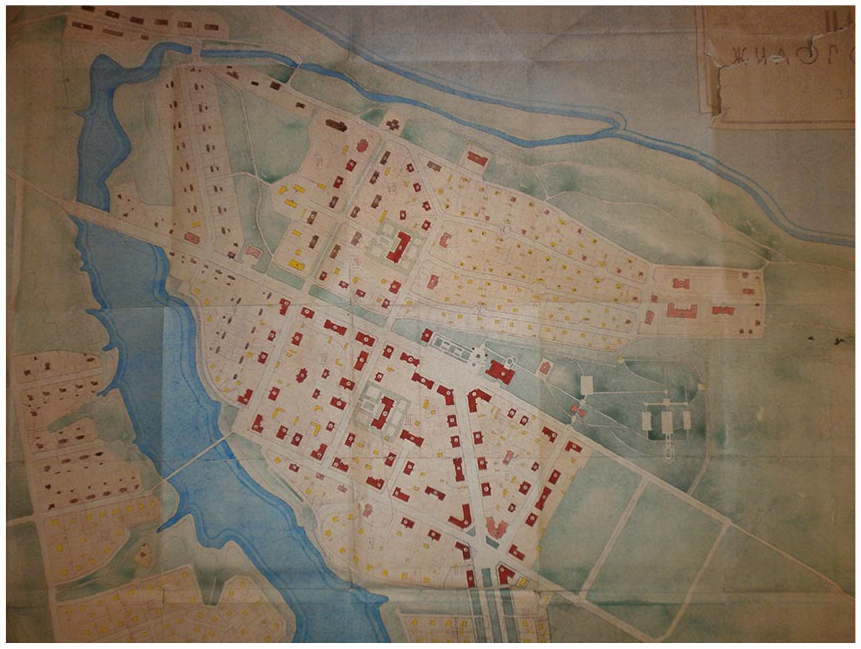
In autumn 1945, the geological exploratory of the East Estonian oil-shale-based graptolitic argillite became more detailed and extended. 35 The exploratory works were taken very seriously—the state was in a hurry. For instance, in the conditions of the post-war acute shortage of fuels and strict limitations on fuels even for the officials, the Committee for Geology allocated to the scientific director of the Institute of Geology of the USSR Altgausen, as leader of the Estonian expedition, unlimited amount of gasoline for his official car “. . . to work on special metals.” 36 Meanwhile, on November 22, 1945, state firm Lengazstroi 37 that belonged to Glavgaztopprom 38 sent to the Department of Architecture of the Estonian SSR a plan and an explanatory report for selecting a 78-ha plot of land to establish a settlement for the workers of the Viktor Kingissepp oil-shale processing and distillation (e.g. producing uranium oxides) factory in Sillamäe. The department, led by Arman, approved the request (Figure 1). 39
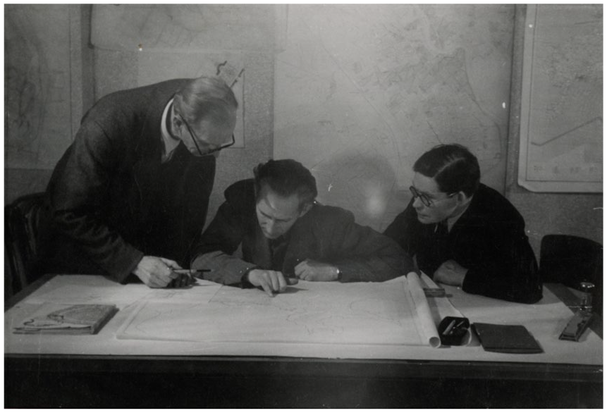
Architect Harald Arman (sitting centre) with architect Anton Soans (left) and architect August Volberg at the turn of 1940s and 1950s. Source: EAM 16.4.56.
On January 17, 1946, the First General Administration presented a strongly top-secret report to Stalin. According to the report, there was not any special exploration of uranium ore in the Soviet Union up to 1944. As the report stated, by the beginning of 1946, there were ascertained 285 tons of uranium ore (as pure metal uranium) deposits in the Soviet Union. Meanwhile, the report’s estimate put the amount of unexplored uranium ore (as pure metal uranium) deposits at 18,390 tons in the Soviet Union, including 17,500 tons in East Estonia. The report mentioned that in East Estonia and Leningrad Oblast, mineshaft building works had been launched and planning of East Estonian experimental uranium oxide factory had been started. 40 The experimental uranium oxide factory was intended to produce 100 tons of uranium oxides per year. 41 According to the top-secret directive of the USSR’s Council of Ministers, passed on April 9, 1946, project of the experimental uranium oxide factory had to be finished by May 1, 1946 and the factory launched by the fourth quarter the same year. The factory was planned to produce 200 tons of uranium oxides per year by 1950. For instance, meanwhile, East European new uranium oxide factories, ruled by the Soviet Union, were intended to produce less uranium oxides per year: Bulgaria 50 tons, Czechoslovakia 30 tons, and Eastern-Germany (Saxony) 5 tons. 42 Strongly top-secret protocol of the Special Committee, compiled on May 18, 1946, shows that its leader Beria 43 ordered the First General Administration to develop a plan of launching East Estonian oil-shale-based heating, gas, molybdenum, vanadium, and uranium oxides production in ten days. The production process had to be as efficient as possible and the arrested German nuclear engineers had to be involved. 44
On July 27, 1946, Beria mentioned in his top-secret letter to Stalin that the Sillamäe experimental uranium oxide factory would produce uranium oxides annually 15 tons in 1947, 80 tons in 1948, 150 tons in 1949, and 200 tons in 1950. To build the factory with settlement, Beria proposed to use ten thousand war prisoners consisting of Estonians, Latvians, and Lithuanians that had served in German army + sixteen thousand criminal prisoners. 45 Those twenty-six thousand prisoners became the first inhabitants of Sillamäe. Due to post-war reconstruction and rehabilitation, there was an acute shortage of labor and even of forced labor in the Soviet Union. For instance, on November 30, 1944, Secretary General of the Central Committee of the Communist Party of Estonia Nikolai Karotamm and Chairman of the Estonian SSR’s Council of People’s Commissars Arnold Veimer asked Stalin to send to East Estonian oil-shale area nine thousand convicts to reconstruct and rehabilitate the area, 46 but without any remarkable results. 47 However, in 1946, due to new circumstances and strategic importance of the object, twenty-six thousand convicts were intended to be used in building of the factory and its settlement.
According to a top-secret directive, passed on July 27, 1946, the USSR’s Council of Ministers, led by Stalin, decided to launch the Sillamäe experimental factory to produce uranium oxides, vanadium, molybdenum, and nickel. The factory’s official name became Refinery No. 7 of the First General Administration at the USSR’s Council of Ministers. The directive, based on the previous 1946 documents, fixed activities for the next half a year: details and dates of building the factory and settlement nearby it, launching of the factory, assignments, additional explorations of East Estonian graptolitic argillite, and amount of its components, first of uranium ore. All found uranium ores both from East Estonia and Leningrad Oblast had to be sent to the new factory. 48 This directive was an official launch for building both the closed factory and its settlement in Sillamäe.
On August 6, 1946, following the top-secret directive of the USSR’s Council of Ministers, passed on July 27, 1946, Secretary General of the Central Committee of the Communist Party of Estonia Karotamm and Chairman of the Estonian SSR’s Council of Ministers Veimer passed top-secret joint directive No. 039. The directive concerns exploration of East Estonian graptolitic argillite, the experimental uranium oxide Refinery No. 7, and territories for developing the closed settlement in Sillamäe. Although the joint directive does not mention Sillamäe, it refers both to Narva as an existing town and to a coastal mining territory for the factory in East Estonia—that corresponds to the above-stated documents. 49
All those activities since autumn 1944, especially since August 1945, and rather short dates show how strategically important was East Estonia for the Soviet Union. That was a solid foundation for urban space planning in that area, first uranium ore deposits and then oil-shale deposits supported its importance. While strategy and tasks of the oil-shale-based uranium oxides production were clear by 1946, the attempts to organize proper strategy for the rest of the oil-shale territory took place in 1947.
Oil-shale—reason for regional planning of East Estonia
The Soviet Union was interested in East Estonian oil-shale deposits that were suitable for heating and producing electricity, oil-shale gas, shale oil, oil-shale gasoline, and so on. As states Olaf Mertelsmann, before the Second World War, in spring 1941, the Soviet Union intended to increase annual total mining of East Estonian oil-shale up to 8 million tons by 1945, for example, more than four times within five years—that amount could have been nearly 80 percent of the whole state’s capacity. 50 However, the war postponed the plans.
As stated above, the Soviet Union was highly interested in East Estonian oil-shale deposits by 1944. On June 15, 1945, the USSR’s People’s Commissar of Coal Industry Vassiliy Vachrushev passed a governmental command concerning reconstruction and rehabilitation of East Estonian oil-shale industry and settlements. The governmental command ordered both central and local state institutions to reconstruct and build fourteen mining shafts to rise total annual mining of oil-shale from 1.9 million tons to 7.8 million tons in the period from 1945 to 1948. The governmental command ordered Lengiproshacht 51 to project the oil-shale mining and industrial settlements and establish living conditions for twenty thousand convicts, thousand workers, design technical schools, hospitals, and clinics. 52 Nearly a month later, on July 10, 1945 the USSR’s Stately Defense Committee fixed a five-year plan (1945-1950). According to the five-year plan, annual total mining of oil-shale had to rise from 1.9 million tons up to 8.4 million tons by 1950. However, both plans (7.8 million tons by 1948 and 8.4 million tons by 1950) were too ambitious—for instance, in 1948, the actual annual total mining was three million tons and, in 1950, 3.54 million tons. 53 Both the order to increase annual total mining over four times just within four to five years and the order to use twenty thousand convicts against the background of the decision of late-1944 concerning 7-km special zone from the coast of Gulf of Finland reflect the Soviet Union’s utter need for the oil-shale deposits.
Although works for the first masterplans of East Estonian oil-shale area started in early-1946, the first attempts to organize the territory took place in mid-1947. On July 20, 1947, the Estonian SSR’s Council of Ministers passed a directive “About organisation of project-planning works for oil-shale region.” According to the directive, the Department of Architecture of the Estonian SSR compiled “Technical-economic principles for development of the Estonian SSR’s region of the occurrence of oil-shale” that does not concern Sillamäe. The technical-economic principles were submitted to Moscow in November 1947. 54
In 1948-1950, the Department of Architecture of the Estonian SSR compiled with its design institute “Estonproyekt” a large secret project “Planning task for industrial and urban development of the Estonian SSR’s region of the occurrence of oil-shale,” printed in 1951 (Figure 2). The secret project followed the directive of the USSR’s Council of Ministers, passed on May 21, 1948. That directive on its turn followed the directive of the USSR’s Council of the People’s Commissars and the USSR Central Executive Committee “About compilation and approval of planning projects for socialist reconstruction of the Soviet Union towns and other settlements,” passed on July 22, 1933. The directive determined that all construction and building in regions that were or had been planned to have solemn or grouped enterprises, towns and settlements serving those enterprises, and that had common transport, energetics, and mineral resources had to be organized on the basis of region development plan. The secret project was successor of the “Technical-economic principles for development of the Estonian SSR’s region of the occurrence of oil-shale” and does not concern Sillamäe or uranium oxides production. 55
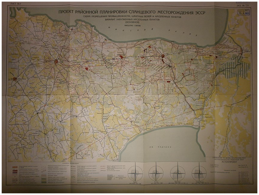
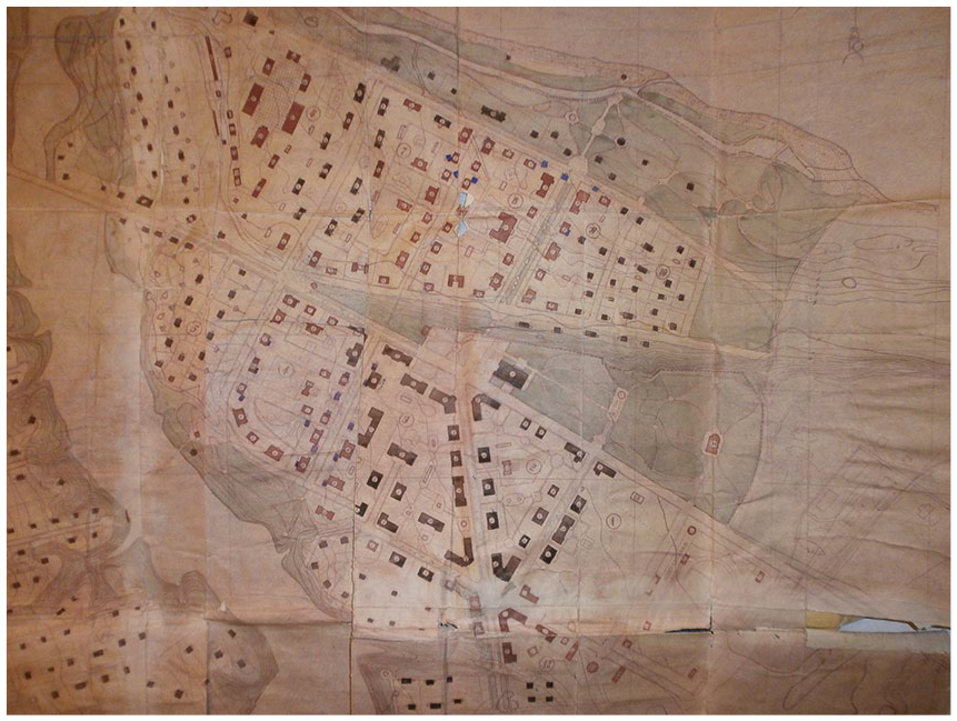
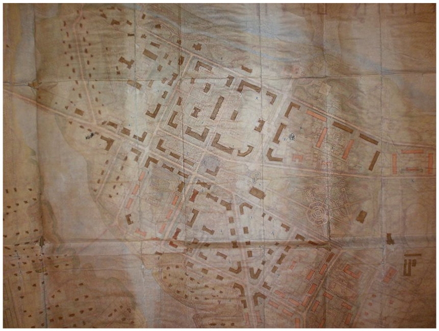
Planning task for industrial and urban development of the Estonian SSR’s region of the occurrence of oil-shale by the Department of Architecture of the Estonian SSR with its design institute “Estonproyekt”, 1951. Top right: Sompa, Kohtla, Kohtla-Järve, Kukruse, Jõhvi, Ahtme. Right: Viivikonna. Centre: Kiviõli. Centre left: Rakvere. Centre: new town Koidu. Centre right: new town Illuka. Source: ERA R-1527.2.44, sheet 7.
The secret project seeks economic efficiency and high productivity for East Estonian oil-shale territory with area of 4000 km2 (from Rakvere to Narva and from Gulf of Finland 40 km-s to South) in the period from 1948 to 1970. The territory contains oil-shale towns (for example, Kohtla-Järve, Jõhvi, Ahtme, Kiviõli) and smaller settlements (for example, Sompa, Viivkonna, Kukruse). The project does not concern textile industry town Narva and closed uranium-oxide-producing town Sillamäe. It consists of plans and explanatory report containing sections such as cartography, climate and nature conditions, water resources, forestry, land use, industry, energetics, agriculture, transport and road network, population and populated areas, water supply and canalization, recreation, sanitary characteristics, and organization of urban and architectural planning. According to the 1949 staff working document and the official 1951 secret project, annual total mining of oil-shale had to rise from three million tons in 1948 and 3.54 million tons in 1950 up to twenty-five million tons by 1970. 56 On March 13, 1954, experts of the GOSPLAN 57 insisted to rise annual total mining of oil-shale up to thirty million tons by 1970 in 1954 staff working document. 58 The official 1951 project’s estimate put the amount of unexplored oil-shale deposits between 3.6 and 6.0 billion tons in East Estonia. The report proposes on the base of estimated deposits of 3.7 billion tons and annual total mining of 12 million tons that the deposits should last for three hundred years. 59 On April 26, 1949, the staff working document proposes to rise population of the towns and settlements including five new towns from sixty thousand people in 1948 up to two hundred forty thousand people by 1970. 60 Eight months later, on December 7, 1949, the indicator of 1970 was increased up to three hundred thousand people in the document. 61 The official 1951 project proposes to rise population from fifty-eight thousand four hundred people in 1948 up to three hundred and five thousand people by 1970. 62 However, in the 1954 staff working document, experts of the GOSPLAN mention rise of population from eighty-six thousand people in 1954 up to three hundred thousand people by 1970. 63 According to the official 1951 project, the annual total mining of oil-shale had to rise for up to ten times and population up to five times within twenty-two years. All that defined needs for urban planning in the oil-shale mining and industrial region.
While in October 1948, there were counted six towns and fourteen settlements in the 4000 km2 oil-shale area then, according to the official 1951 project, the same area was planned to have ten towns (five new ones + five existing ones, including unification of two towns) by 1970. The existing towns and settlements were intended to reorganize, regroup, and enlarge to increase economic efficiency and high productivity of the oil-shale area. The section of organization of urban and architectural planning contains analyses of existing mining shafts and planning of new ones, arrangement of oil-shale industry, perspectives of existing towns and settlements, and arrangement and building of new towns. 64 The staff working documents contain density of population and number of stories for houses of the towns by 1970. 65
Crude oil—dreams, ambitions, and reality
Importance of the oil-shale area improved industrial perspectives of the whole Estonia—the aspect that, on its turn, influenced formation of Stalinist urban space of East Estonian oil-shale mining and industrial towns, indirectly. For instance, against the background of perspective oil-shale gas, the official 1951 report considers Estonian limited natural gas deposits, while variable in quality, worth to be researched. The same document mentioned crude oil prospecting in Estonia. 66 East Estonian oil-shale-based industry seemed prosperous for the Soviet Union and inspired local authorities’ ambitions, as well. On November 28, 1948, Secretary General of the Central Committee of the Communist Party of Estonia Karotamm wrote a letter to the USSR’s Minister of Geology Ilya Malyshev and insisted him to intensify crude oil prospecting all over Estonia within the nearest future in 1949. Karotamm convinced Malyshev to continue explorations of natural gas, to start exploration of asphaltites in East Estonia and to focus on crude oil prospecting—“. . . because even the Second Secretary of the Communist Party of the Soviet Union Andrei Zhdanov had suggested to prospect crude oil in Estonia consistently.” According to Karotamm’s proposal, there should have been made five prospecting boreholes: three in North Estonia and two in South Estonia and West Estonia in 1949. Several additional prospecting boreholes on six west-east lines, counted down from the north to the south, should have been drilled within the next years. On December 11, 1948, Malyshev responded that Estonian natural gas deposits were limited and variable in quality and crude oil prospecting had been taken place in some Estonian localities without positive results. However, he admitted there should have been potential crude oil deposits in South Estonia. 67 A question of crude oil raised importance of East Estonian oil-shale area higher. Such political and economical local ambitions as one kind of mechanisms boosted formation of East Estonian oil-shale mining and industrial towns by local authorities.
Ideological, Architectural, and Urban Mechanisms
The Department of Architecture of the Estonian SSR and its leader processed masterplans and construction plans of all local towns, including masterplans and construction plans of East Estonian oil-shale mining and industrial towns. 68 What was the actual role of the Department of Architecture of the Estonian SSR as a local branch of the USSR’s State Committee of Architecture?
The USSR’s State Committee of Architecture was found as a result of need to administrate and control the Soviet Union’s urban planning and architecture efficiently with quick and thorough results. On August 16-18, 1943, the eleventh plenum of the Governing Board of the Union of Soviet Architects of the USSR analyzed war-time urban planning practice of evacuees’ functional settlements in the eastern regions of the state and attempts to restore wrecked towns and industrial centers in the recaptured central regions and necessities of post-war mass-building in urban space. Central issue of the plenum was miserable reality, full of serious shortcomings, such as low quality of projecting, planning, reconstruction, building within poverty, and indifference. There was an acute lack of professional architects, urban planners, order and discipline within survived architects and builders, disorder, chaos and thefts within officials of towns and settlements, and local authorities. The tempo of reconstruction and rehabilitation of towns, industrial centers, and built-up areas had stalled. Meanwhile, the state had put pressure on the Union of Soviet Architects of the USSR to guarantee quick, thorough, and efficient results in the field of restoring industrial centers, towns, and settlements in the recaptured western areas. The plenary resolution obliged the Union of Soviet Architects of the USSR to ask the USSR’s Council of People’s Commissars to establish an all-encompassing governing and controlling architectural institution with strong administrative power. 69
Why did the Union of Soviet Architects of the USSR focus on those urban planning shortcomings exactly midst the deep war, while, for example, the siege of Leningrad 70 was still actual?
Three months after the siege of Moscow, during the siege of Leningrad and before the battle of Stalingrad, 71 on April 25, 1942, the tenth plenum of the Governing Board of the Union of Soviet Architects of the USSR called architects to follow the Soviet troops for the western regions; to estimate destructions of towns, architectural monuments, and industrial complexes; to seek for opportunities to start simple massive building with simple maintenance and restoration of industrial complexes; to use local mineral resources and materials; and to help local authorities in urban planning and compiling of building norms. Architects were called to popularize architectural monuments to evoke patriotism among people and deal with war commemoration monuments, nationalist folklore motifs, and local traditions in appearance of towns and built-up areas. 72
Over a year later, on July 24, 1943, architect Karo Alabyan published an article “Contours of future Stalingrad” that set new compositional principles for post-war urban planning, urban space, and urban ensemble—the principles complemented with a victory theme. 73 However, in the eleventh plenum, reflection of those compositional novelties practically did not get any attention, even the victory theme was considered formally. The central issues of the plenum were concern for the failed situation and hopeless perspectives in the field of urban planning and need for an all-encompassing governing and controlling architectural institution.
While the tenth plenum was optimistically focused on estimating of war destructions, seeking for restoration opportunities, popularization of architectural monuments, and aesthetics, the eleventh plenum had shifted the focus on shortcomings of the real practice of the restoration, need for quick and efficient solutions. The state had put pressure on the Union of Soviet Architects of the USSR to guarantee quick, thorough, and efficient results in the field of restoration of industrial centers, towns, and settlements in the recaptured western areas due to acute need for uranium ore that had become strategically and military important in 1942, while the Soviet Union realized that Germany, Great Britain, and the United States were trying to produce uranium reactor and uranium-based atom bomb. The top-secret administrative order of the USSR’s State Defense Committee, passed on September 28, 1942, concerning production of uranium-based bomb or uranium-based fuel formulated a new doctrine for restoration of industrial centers, towns, and settlements in the recaptured western areas. The Soviet Union was in a race against time. Urban planning became both political and militant issue. The state needed architects and specialists to embody visions of the power, the state. East Estonian oil-shale had become one of the focal points for the Soviet state. Due to ongoing war, the shift was caused by militant reasons, connected both with the results of the war and the post-war situation in the Europe and in the World.
The request of the eleventh plenum was taken into consideration already in four days. The resolution of the USSR’s Council of People’s Commissars “About immediate means for economy reconstruction on the territories liberated from German occupation,” passed on August 22, 1943, compelled all architectural and building workshops, organizations, and institutions to bunch under one all-encompassing institution to restore settlement of the state. 74
Nearly a month later, on September 29, 1943, the USSR’s Council of People’s Commissars and the Communist Party of the Soviet Union established the USSR’s State Committee of Architecture at the USSR’s Council of People’s Commissars (similarly as the USSR’s State Defense Committee at the USSR’s Council of People’s Commissars). The USSR’s State Committee of Architecture under the direct authority of the USSR’s Council of People’s Commissars became the highest executive power of the Soviet urban planning and architecture. The institution with its head administrated and controlled all questions concerning urban planning and architecture, including building. Tasks of the USSR’s State Committee of Architecture were as follows:
approval and certification of planning and building projects of towns, settlements, industrial complexes, objects, important administrative and public buildings, urban ensembles, and residential buildings;
state architectural and building quality control of towns, settlements, industrial complexes, urban ensembles, public buildings, administrative buildings, and residential buildings;
development and approval of design, construction, and building norms and regulations;
supervision, monitoring, and control of architectural, design, and building organizations;
curating of architectural research and experimental institutions and architectural education in colleges and universities; and
defense of architectural monuments and curating of restoration works.
The USSR’s State Committee of Architecture had to develop and submit for approval to the USSR’s Council of People’s Commissars:
draft regulations of planning and building projects of towns, settlements, industrial complexes, objects, important administrative and public buildings, urban ensembles, and residential buildings;
… draft regulations concerning production of new building and finishing materials, experimental buildings, and innovation proposals.
The USSR’s State Committee of Architecture, led by architect Arkadi Mordvinov, had to establish local branches under the direct authorities of the local Councils of People’s Commissars. One of them was the Department of Architecture of the Estonian SSR at the Estonian SSR’s Council of People’s Commissars. 75
The Department of Architecture of the Estonian SSR, led by Arman, had similar highest executive power of urban planning and architecture on territory of the Estonian SSR, including planning of East Estonian oil-shale mining and industrial towns Jõhvi, Kohtla-Järve, Ahtme, Sompa, Kukruse, Kiviõli, Kohtla-Nõmme, Viivikonna, and closed Sillamäe. The thirty-four-year-old head of the Department of Architecture of the Estonian SSR returned to Estonia in autumn 1944. Meanwhile, Arman had begun to organize the restoration of Estonian towns while based in the Soviet Union, in mid-1944. 76
Thus, East Estonian towns were processed by the Department of Architecture of the Estonian SSR. The leading architectural institution sometimes convened the Architectural Council of the Estonian SSR. The council consisted of architects from the Department of Architecture of the Estonian SSR and the Union of Soviet Architects of the Estonian SSR, officials, and specialists. Arman was leader of the council.
Results of the 1951 Secret Project and Arman’s Influence
Under the guidance of Arman, the Department of Architecture of the Estonian SSR was deeply involved in urban planning of East Estonian oil-shale towns (including closed Sillamäe) and played decisive role with its full measure of authority.
For instance, in 1947, the institution got from the USSR’s State Committee of Architecture exceptional right to use individual designs instead standardized designs for buildings within the planning-task of the oil-shale region. 77 According to 1949 staff working documents, the Department of Architecture of the Estonian SSR proposed in “Technical-economic principles for development of the Estonian SSR’s oil-shale occurrences territory,” passed in 1947, to use three-storied houses with density of two hundred people/1 ha (10% of housing stock in towns with population more than 15,000 people), two-storied houses with density of hundred to one hundred fifty people/1 ha (60%-70% of housing stock in towns with population more than fifteen thousand people; 65%-75% of housing stock in towns with population below fifteen thousand people), and garden-type one-storied houses (20%-30% of housing stock in towns with population more than fifteen thousand people; 25%-35% of housing stock in towns with population below fifteen thousand people). 78 However, the USSR’s State Committee of Architecture suggested the Department of Architecture of the Estonian SSR to increase percentage of three-storied houses and to use four-storied houses so as to increase density of population to two hundred fifty people/1 ha for two- to three-storied houses and to one hundred fifty people/1 ha for one- to two-storied houses. 79
In the official 1951 secret project, to increase economic efficiency and high productivity of the oil-shale area, the Department of Architecture of the Estonian SSR proposes to intensify housing: first, by building two- to three-storied houses in all towns and second, by increasing percentage of two- to three-storied houses up to 70 to 80 percent of housing stock, while decreasing percentage of one-storied houses down to 20 to 30 percent of housing stock. The aim of such a proposal was to decrease territory under settlements from 5,000 to 3,300 ha—it means 1,700 ha more for oil-shale mining—while increasing general amount of population on the territory with area of 4000 km2 by 1970. 80
What was the result of such a proposal that formulated official policy for urban planning of the territory? In staff working documents, the Department of Architecture of the Estonian SSR indicated onto failed urban planning of Kohtla-Järve due to too close mining shafts and deeply polluted soil (proposal to decrease existing amount of population form fifteen thousand people to five thousand people), but the USSR’s State Committee of Architecture suggested to save the situation by intensifying housing. 81 In 1951 official secret project, the Department of Architecture of the Estonian SSR exposed Kohtla-Järve with its new satellite Kohtla with a population of nineteen thousand people and seventeen thousand people, accordingly—all together thirty-six thousand inhabitants by 1970. 82 Probably, due to possibility to get more land of previous mining areas and intensifying housing (caused by intensified industry), amount of population of Kohtla-Järve reached to 40,464 (fifty-one thousand two hundred, as Kohtla-Järve agglomeration [since 1960] without Jõhvi and Ahtme) by 1959. 83 Meanwhile, probably in connection with such a development, building of new town Kohtla, plan designed by Lengiproshacht, was canceled. 84 The 1951 official secret project indicates to decreasing of amount of population for Sompa from fifteen thousand people to nine thousand people, while one- to two-storied houses were replaced with two- to three-storied houses. 85 Such a change caused discard of three-fourths of the masterplan designed by Lengiproshacht. 86 The same reason caused discard of two-thirds of the masterplan designed by Lengiproshacht for Ahtme. 87
The aim to decrease territory under settlements from 5,000 to 3,300 ha, to get 1,700 ha for oil-shale mining, while increasing general amount of population, formulated a pattern of urban planning and urban space of the territory. East Estonian oil-shale mining and industrial towns got compact and city-like housing stock, consisting of dominant apartment buildings and monumental public buildings that form functional stately urban ensembles nearby industrial complexes. Those principles were implemented in Sillamäe, as well, due to Arman’s active processing of the town’s masterplans and design documents.
Question of Urban Composition—Ambitions and Implementations
While Ahtme, Sompa, Kukruse, Kohtla, Jõhvi, and Viivikonna were designed mainly by Lengiproshacht (architects B. Sokolov, A. Volkova, G. Ivanov), Kohtla-Järve and Sillamäe were erected according to the projects, designed by Lengorstroyproyekt. 88 Masterplan and urban space of Kohtla-Järve were designed by architects Jevseiy Vitenberg, I. Pisareva, and F. Kirzideli. Closed Sillamäe was designed architects Alexandr Nikayev and Michail Pospechov. Since Sillamäe was closed uranium-oxide-producing town, the Soviet nuclear industry (Leningrad filial of NII-9 89 in 1946-1947; Leningrad filial of GSPI-12 90 in 1949-1950, 1958) designed the town together with Lengorstroyproyekt. Masterplan of Kiviõli was compiled by the Planning and Design Office, design institute “Estonproyekt” of the Department of Architecture of the Estonian SSR (architects Otto Keppe and Olev Soans).
Lengiprosacht laid out Jõhvi, Ahtme, Sompa, Kukruse, Kohtla-Nõmme, and Viivikonna using regular and simple grids, the same concerns unbuilt Kohtla nearby later built Kohtla-Nõmme (Figure 3). However, masterplans of Sompa and Ahtme were not organized using orthogonal geometry and contained radial street patterns at one corner of the grid like in Kohtla-Järve, designed by Lengorstroyproyekt (Figure 4). Masterplan of Kiviõli, designed by the Planning and Design Office of the Department of Architecture of the Estonian SSR, exploits the same radial street pattern. Stalin-era masterplan of Kukruse and probably of Kohtla-Nõmme were designed by Lengiproshacht, as well. Due to absence of copies of the masterplans in archives, it is hard to estimate to what extent these two towns were implemented. The masterplan of Ahtme was implemented to an extent of one-third, the masterplans of Sompa and Kiviõli each to an extent of one-fourth, and the masterplan of Viivikonna to an extent of half. 91
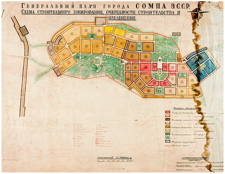
Masterplan of Sompa, 1946 by Lengiproshacht (B. Sokolov). Left quarter: realised part of the town. Centre and right: unbuilt part of the town. Source: EAM 3.1.248.
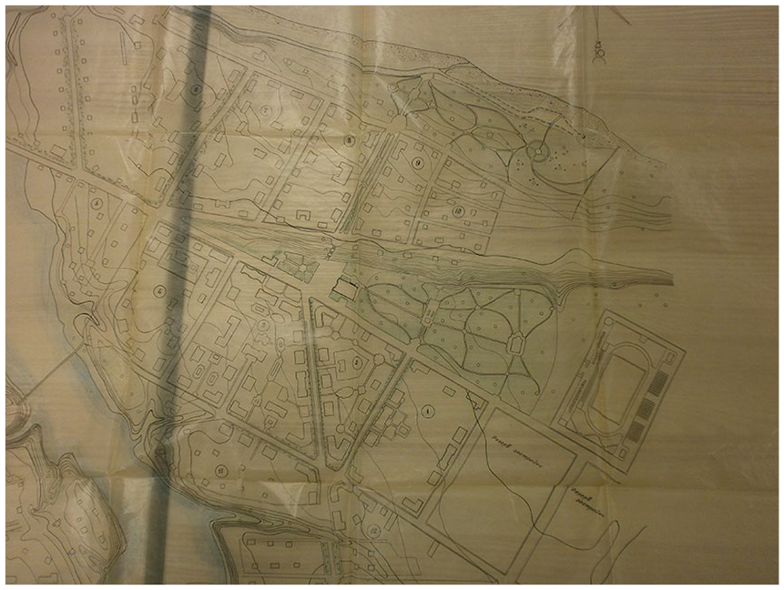
Centre of Kohtla-Järve crossing axes, 1951 (Otto Keppe) following version of Lengorstroyproyekt. Centre: Victory Boulevard and stadium between converging axes. Park and the pre-war settlement (left) formed 2-kilometre sanitary zone. Source: ERA T-14.4-6.34581.
Against the background of the 1947, 1949, 1951, and 1954 documents concerning development of the oil-shale region, the Department of Architecture of the Estonian SSR processed the masterplans, designed by Lengiprosacht, thoroughly. Even the Department of Local Air Defense of the Estonian SSR’s Ministry for Internal Affairs and the Department of Local Air Defense of the USSR’s Ministry for Internal Affairs needed approvals from the Department of Architecture of the Estonian SSR. That concerns unbuilt Kohtla, 92 Ahtme, 93 Jõhvi, 94 Sompa, 95 Kukruse, 96 and Viivikonna. 97 The same concerns Kiviõli, designed by the department itself. 98 Masterplan of Kohtla-Järve, designed by Lengorstroyproyekt, was processed by the Department of Architecture of the Estonian SSR thoroughly, as well. 99 Even masterplan of closed Sillamäe, designed by Lengorstroyproyekt with the Soviet nuclear industry, was processed by the Department of Architecture of the Estonian SSR thoroughly. 100
Use of similar radial street pattern at one corner of the grid on one hand, in 1947-1954 masterplan of Kiviõli and, however, in 1946 masterplans of Ahtme, Sompa, and Kohtla indicates to influence of Lengiprosacht on the Department of Architecture of the Estonian SSR. Even Lengorstroyproyekt used the same pattern in 1947 masterplan of Kohtla-Järve, but not in 1946-1950, 1958 masterplans of Sillamäe (Figure 5). The Department of Architecture of the Estonian SSR, while processing the masterplans of East Estonian oil-shale mining and industrial towns, on its turn influenced Lengorstroyproyekt.
Sillamäe centre by Lengorstroyproyket (Alexandr Nikayev), 1948. Centre: Central Square with Palace of Culture (right). Right: recreation area and park. Source: Detalny proyekt, Tom I, GSPI-12, 1948.
However, the more complex and challenging masterplans, designed by Lengorstroyproyekt, got more attention in comparison with the regular and simple grids-based masterplans, designed by Lengiproshacht. Stately urban ensembles of Sillamäe and Kohtla-Järve as quintessence and backbones of those masterplans, designed by Lengorstroyproyekt, followed orthodox Stalinist principles more in comparison to that of stately urban ensembles within masterplans, designed by Lengiproshacht. Responding to a leading Soviet architects and theoreticians Ivan Zholtovskij’s and architect Mordvinov’s principles of urban design, 101 the Stalin-era architects and designers of Sillamäe and Kohtla-Järve tried to embody an approach to that implied a prosperous future—a kind of socialist paradise. These towns had to demonstrate the advantages of the Socialist system over its capitalist competitor by means of compositional unity and the illusion of luxurious facades, courtyards, parks, and inspiring sculptures.
Stately urban ensemble as center of Kohtla-Järve was built about 1 km to the east of the pre-war settlement. The last one with the distance of 1 km had to form a 2-km sanitary zone between oil-shale mine with industry and new town “sotzgorod” (socialist town). 102 Stalinist stately ensemble as urban space of the town consists of two crossing main axes. The southwest–northeast one, named Victory Boulevard (now Kesk Boulevard), that is more than 50 m wide and 700 m long, connects the Palace of Culture with a park and the cinema (Pobeda, “Victory”; on the axis of the boulevard). The Victory Boulevard is crossed by the southeast–northwest axis of Rahu (Peace) Square (200 m long, 125 m wide), which was intended to concentrate local government building and four-storeyed apartment buildings with colossal orders and avant-corpses. The rest of the houses on the crossing axes are two- to three-storeyed apartment buildings with pitched roofs (Figure 6). 103 In 1956, local architect V. Tippel from “Estongiprogorstroi” 104 made a supplementary masterplan for Kohtla-Järve that clearly follows previous versions of Lengorstroyproyekt. Nearly 3/4 of the masterplan was implemented. 105
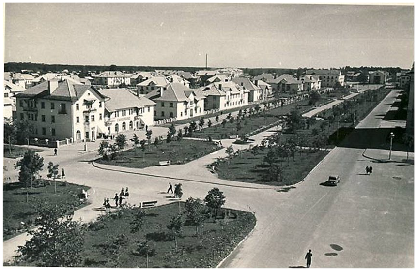
Stalinist centre of Kohtla-Järve, early 1950s by Lengorstroyproyekt (Jevseiy Vitenberg, I. Pisareva, F. Kirzideli). Perspective view along the Victory Boulevard. Photo taken from crossing of the main axes in 1950s. Source: RM F 646.176.
The near complete implementation of the Stalinist masterplan in Sillamäe makes it fairly unique occurrence both in Estonia and the former Soviet Union. Processing of uranium oxides for the nuclear industry gave Sillamäe a special position and promoted the rapid and planned development. For instance, the same development concerned nuclear towns such as Ozersk (Ural), Zheleznogorsk (Siber), Seversk (Siber), and Ozyorsk (Chelyabinsk-65; Siber).
Sillamäe’s center as stately urban ensemble of the town consists of three main streets and a boulevard crossing the central square and recreational area. Southeast- to northwest-oriented 30-m-wide converging Kalda and Kesk Streets are situated on two coastal levels and surround a park. The two streets converge at the Central Square of 140 × 120 m that consists of a junction, greenery, flanked with Corinthian Palace of Culture, towered town hall, and a grand staircase that leads to 40-m wide and 250-m-long Mere Boulevard that connects with the sea. The boulevard is flanked with monumental four-storied apartment houses. The composition of the boulevard and the staircase is similar to Stalingrad staircase axes (monumental staircase between Volga River and Alley of Heros [Alleya Geroyev]). The rest of the stately urban ensemble is housed with neo-classicist apartment houses, public buildings ornamented with bas-reliefs, balustrades, pediments, and columns.
The current grid of the town was developed within the years of 1946-1950 and 1958. The Department of Architecture of the Estonian SSR processed at least the masterplans of 1946-1948. Stalinist central gridlines of the masterplans for Kohtla-Järve and Sillamäe have many compositional similarities with Stalinist central gridlines of Tallinn and Pärnu, designed by Arman. He designed the masterplans for Tallinn and Pärnu through the mid-1940s and early-1950s. It would be logical that the Stalinist central gridlines of Tallinn and Pärnu were inspired by the compositions, designed by Lengorstroyproyekt. However, it is on the contrary. Arman crossed converging axis with boulevard already in the 1945 masterplan of Tallinn and Cultural Center composition (Figure 7).
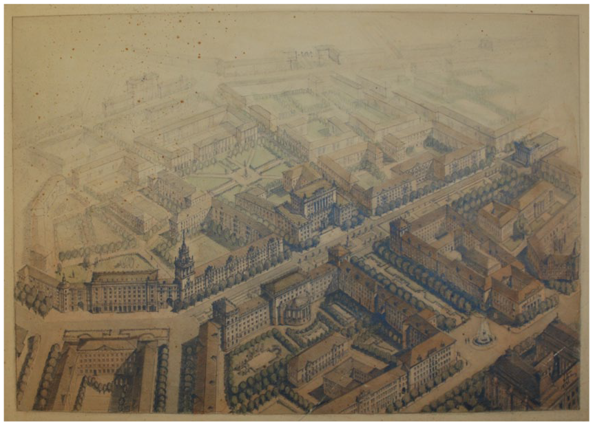
Design for the Cultural Centre in Tallinn, 1945 – 1953 by Harald Arman. The 1953 version. Bottom right: Estonia Theatre near Estonia Boulevard. Centre: Academy of Sciences of Estonian SSR building near Lenin Boulevard. Top left: between prolongated axes was planned a stadium, built in 1955. Source: EAM 3.1.32.
He reused the solution in the 1952 Pärnu Oblast Center composition. Neither the Sillamäe 1946-1947 masterplan nor the 1948 masterplan used crossing of converging axes and boulevard—but those are clearly visible on the 1949 (Figure 8), the 1950 (Figure 9), and the 1958 masterplans (Figure 10). Even more, location of stadium in those three masterplans resembles to his mid-1940s and early-1950s Tallinn masterplans. Arman actively processed the masterplans at least up to summer 1949 and was in touch with later masterplan versions via correspondence with Lengorstroyproyekt. For example, the 1948 masterplan 106 had an additional variant 107 that is influenced by Arman even more. 108 The same is visible in the 1950 masterplan within top-secret regulations of the Estonian SSR’s Council of Ministers. 109 The 1958 masterplan of Sillamäe reflects realized situation and ideas of enlarging the town. 110 It seems as masterplans, designed by Lengorstroyproyekt, had been under Arman’s heightened attention. In 1949, the Department of Architecture of the Estonian SSR awarded the first prize to Sillamäe for excellent and comprehensive implementation of masterplan. 111
Sillamäe centre by Lengorstroyproyekt (Alexandr Nikayev and Michail Pospechov), 1949. Centre: Central Square with Palace of Culture (right) and grand staircase (top). Top right: Mere Boulevard crossing with converging axes via the staircase. Bottom right: stadium near converging axes. Source: SLV Proyekt planirovki, GSPI-12, 1949.
Sillamäe centre by Lengorstroyproyekt (Alexandr Nikayev and Michail Pospechov), 1950. Centre: Central Square with Palace of Culture (right) and grand staircase (top). Top right: Mere Boulevard crossing with converging axes via the staircase. Bottom right: stadium between converging axes. Source: ERA R-1.5s.212, 10–4.
Sillamäe centre by Lengorstroyproyekt (Alexandr Nikayev and Michail Pospechov), 1958. Centre: Central Square with Palace of Culture (right) and grand staircase (top). Top right: Mere Boulevard crossing with converging axes via the staircase. Bottom right: stadium between converging axes. Source: SLV Generalny plan, zakaza 229, 1958.
Aspect of the Population Growth
According to abovementioned documents, population of the 4000 km2 area (without Sillamäe) was sixty thousand people in 1948, eighty-six thousand people in 1954, and was planned to be from two hundred forty thousand up to three hundred five thousand people by 1970. If to compare years of 1948 and 1954, while increase in population was twenty-six thousand, then on the base of such a tempo the amount of population could have been one hundred fifty five thousand people in 1970 and three hundred twenty nine thousand in 2010. The difference between actual figure of the 1970 and the project planned-figures would have been 1.5 to 2.0 times. Consequently, the secret project proposes accelerated increase of population to increase economic efficiency and high productivity of East Estonian oil-shale mining and industry.
Conclusion
There were ideological, architectural, and urban mechanisms in forming urban plans and urban spaces of East Estonian oil-shale mining and industrial towns. Those mechanisms were driven by military and economical mechanisms of the Soviet Union as well as local authorities’ (Karotamm, Veimer) eagerness and ambitions. Meanwhile, local state architect Arman, as head of the Department of Architecture of the Estonian SSR, was deeply involved in urban planning of East Estonian oil-shale towns, including closed Sillamäe and played decisive role with its full measure of authority. The institution formulated pattern of urban planning and urban space of East Estonian oil-shale mining and industrial towns.
Those towns were designed to be compact and functional with city-like intensified housing stock and stately urban ensembles and without remarkable enlargements. On the behalf of economic efficiency, high productivity, increase of general population was planned via optimizing of population of the towns and intensifying the housing stock. The optimization, on its turn, was caused by the occurrence of oil-shale deposits in certain territories nearby and under the towns. The pattern of urban planning and urban space defines Stalinist urban ensembles of centers of East Estonian oil-shale mining and industrial towns that were formed by ideological and architectural mechanisms, driven by military and economical mechanisms. The mechanisms, defined by functional needs of the Soviet state and power, as well as local ambitions, formed Stalinist masterplans, urban composition, urban space, large scale, and formulated aesthetics and Corinthian style of East Estonian oil-shale mining and industrial towns. While urban space of Estonian Soviet Stalinist period, between 1944 and 1955, influenced urban space of East Estonian oil-shale mining and industrial towns, the latter one influenced the first one, as well.
Footnotes
Declaration of Conflicting Interests
The author(s) declared no potential conflicts of interest with respect to the research, authorship, and/or publication of this article.
Funding
The author(s) received no financial support for the research, authorship, and/or publication of this article.