






Abstract
Dividing the City uses a newly discovered, parcel-level, record of restrictive covenants (circa 1850-1950) to document the scope, variety, location, timing, dissemination, and impact of racial restrictions in the City of St. Louis. We underscore the important differences, in their use and their impact, between new subdivision restrictions and petition-based restrictive agreements in older neighborhoods. And we establish the importance of these restrictions to both a dramatic increase in residential segregation before 1950 and the maintenance of that segregation—through public and private policies that emulated and adapted these restrictions even after the Supreme Court held them unenforceable—across the ensuing decades.
On February 11, 1893, Emma J. Van Wort purchased several parcels of land, fronting one hundred feet on the south side of Minerva Avenue in northwest St. Louis, from Matthew and Annie Sullivan. The purchase price was $3,250 (about $95,000 in 2020 dollars), and the deed of sale carried with it several conditions: that seven feet at the back of the lot would be reserved for an alley; that any buildings constructed on the lots would be at least two stories in height and set back at least fifteen feet from the street; that none of the lots would be used for “manufacturing purposes, such as soap factories, tanneries and such”; and that the neither the buyer nor her heirs would ever “sell, convey or transfer any of their property to colored people.” A month later, the Sullivans sold another eighty feet of frontage on Minerva Avenue, attaching the same terms and conditions. 1
On February 2, 1950, the developer Cyrus Crane Fillmore filed an indenture with the St. Louis Recorder of Deeds, specifying restrictions on lots in “St. Louis Hills Estates No. 4,” an expansion of Fillmore’s extensive residential development on the City’s south side. The indenture, based largely on one filed twenty years earlier for Fillmore’s original “St. Louis Hills” subdivision, listed eighteen restrictions and conditions covering everything from building lines to porch design. Restriction 10 provided that no lot covered by this indenture, or any part thereof, shall ever be sold, resold, conveyed, granted, devised, leased, or rented to or occupied by, or in any other way used by any person or persons not of the Caucasian Race . . . provided however, that this restriction shall not be applicable to domestic servants in the employ of the owner.
To drive home the gravity and importance of this clause, Fillmore added—to this restriction alone—an enforcement provision: In the event of a breach of this restriction . . . the title of such lot shall immediately revert to the Company . . . the Company, its successors or assigns may thereupon re-enter and take possession of the lot, with all the improvements thereon.
2
The 1893 deed covenants on Minerva Avenue were the first racially restrictive deed covenants recorded in St. Louis. The St. Louis Hills Estate No. 3 restriction, drafted more than a year and a half after the Supreme Court declared such provisions unenforceable in Shelley v. Kraemer (1948), was probably one of the last. In the intervening half century, St. Louis property owners, neighborhood associations, realtors, and developers would craft more than eight hundred restrictive agreements of this kind.
It is hard to overestimate the importance of these restrictions, in St. Louis and beyond, as a symbol and a driver of residential segregation and as a source of durable racial disparities in housing opportunity and household wealth. Indeed, this was the consensus of contemporary observers. “While the restrictions are private measures,” as one study concluded in 1943, “they can be exceedingly effective if used on a large scale.” 3 “If the Court should follow up its action of declaring all local laws to segregate Negroes unconstitutional by declaring illegal also the private restrictive covenants,” as Gunnar Myrdal underscored in 1944, “segregation in the North would be nearly doomed.” In his 1948 examination of The Negro Ghetto, Robert Weaver identified racial covenants as the “principal instrument for effecting residential segregation in northern and border states,” adding that “of all the instruments that effect residential segregation, race-restrictive covenants are the most dangerous.” 4 For its part, the National Association for the Advancement of Colored People (NAACP) viewed residential restrictions as important in their own right—“the foremost problem confronting Negroes today” as Thurgood Marshall put it in 1945 5 —and as the root cause of the segregation of education and other public goods. 6
Scholarly assessments, in turn, identify racial restrictions not just as one mechanism is in a long history of exclusion and segregation, but as a foundational element of that history. Racial restrictions rendered formal and routine—even respectable and prudent—what had long been accomplished through intimidation or violence. They hardened assumptions about racial occupancy and property values that would become central tenets of professional realty and home finance. They (and their assumptions) lived on in both local land use and economic development policies, and in the tangle of public policies and private practices that constitute “redlining.” 7 In most northern urban settings, segregation was accomplished by racial restrictions (and the violence and intimidation that accompanied them) and sustained by succeeding policies and practices.
Yet, while the importance and impact of racial covenants is widely recognized, we know relatively little about their adoption, diffusion, or consequences in any given setting. The reason for this is quite simple: the restrictions and agreements themselves are buried in county deed records, which are organized and indexed by the date documents are filed with the County Recorder. Restrictive agreements are interspersed with property deeds, quit-claims, sewer liens, and all the other routine business undertaken by the Recorder’s Office. They are not routinely attached to the chain of title (the buyer in the Shelley case had no idea the property was restricted). And the records themselves are vast (the deed books for St. Louis from 1900 to 1950 run over 3.2 million pages), mostly handwritten, and unsearchable. So, unless restrictions are identified in a property transaction or legal proceeding, they are virtually inaccessible and undiscoverable. Such restrictions were clearly important but, as Kevin Fox-Gotham underscores, “there is no systematic evidence” as to their scope. 8
Data and Methods
This article exploits an unusual resource to explore the scope, timing, diffusion, and impact of the race-restrictive deed covenant in the City of St. Louis. Colleagues and I recently discovered a detailed register of St. Louis restrictions, recorded over the last century by one of the City’s major title and abstract firms. Between 1850 and 1950, this register catalogs 1,941 restrictive covenants, 840 of which (43%) including restrictions on racial occupancy. The register lists restrictive agreements by the Recorder’s book and page number and the date recorded, and indicates the presence of a racial restriction, a reversionary clause, or an expiration date. Because the “Yes/No” recording of racial restrictions was incomplete, we examined every deed record in which that field was marked “Yes” or left blank. Of the full catalog, 414 were originally coded as racial restrictions, and 426 of the 584 restrictions in which this field was blank were found to have racial restrictions. 9
We copied and examined each deed record and cataloged its key elements—including the date, the type of agreement, the expiration term and date, the language of the racial restriction, the presence of other restrictions, and (when relevant) the number of signatories to the agreement. We then matched the spatial information in each record (usually a legal descriptions or city block reference) to the City of St. Louis parcel data (2003) and mapped each restricted parcel by date and type of restriction. Where possible, we also added to the parcel record other historical data (such as the security ratings compiled by the Home Owners’ Loan Corporation). Of the 840 racial restrictions identified in the original register, seventy-two were duplicates (or filings which merely added signatories to existing restrictions) and five rescinded standing agreements—leaving a total of 763 unique restrictive covenants or agreements.
The resulting database and map allows us to craft not only a detailed portrait of the scale and reach of these agreements but also the pace and pattern by which they spread, and the driving forces behind their use. While we have a solid understanding—both nationally 10 and in some metropolitan settings 11 —of the language, intent, and legal implications of these restrictions, this resource allows us to map them in space and over time, and to establish with precision the ways in which homeowners, homeowners associations, developers, and realtors contributed to their use and to their diffusion.
Findings
Varieties of Restriction
Deed covenants and restrictions were commonplace in private realty, and attached conditions or prohibitions to real estate transactions, specifying lot setbacks, building materials, garage or fence placements, acceptable uses of property (usually by regulating or prohibiting commercial use), utility easements and—in some instances—even the minimum value of houses. Through these instruments, developers imposed not just private precursors for building codes and land-use zoning (the constitutionality of which was not settled until 1926 12 ) but also prohibitions against a wide array of “nuisances.” Put another way, such covenants focused on both securing positive obligations (such as design and maintenance standards) from property owners and protecting them from any negative actions by their neighbors. 13 Such restrictions and covenants were widely used in St. Louis, especially in the latter half of the nineteenth century. Of the 839 restrictions recorded in St. Louis before 1900, 92 percent imposed conditions other than racial occupancy. This pattern flipped after 1900, as public building codes and zoning increasingly set those standards, and the urgency of regulating racial occupancy pushed to the fore. After 1900, conventional restrictions persisted (especially in subdivisions looking to sustain more exclusive standards) but over 70 percent of all recorded restrictions included clauses on racial occupancy and (with the exception of the subdivision restrictions) increasingly invoked only racial restrictions.
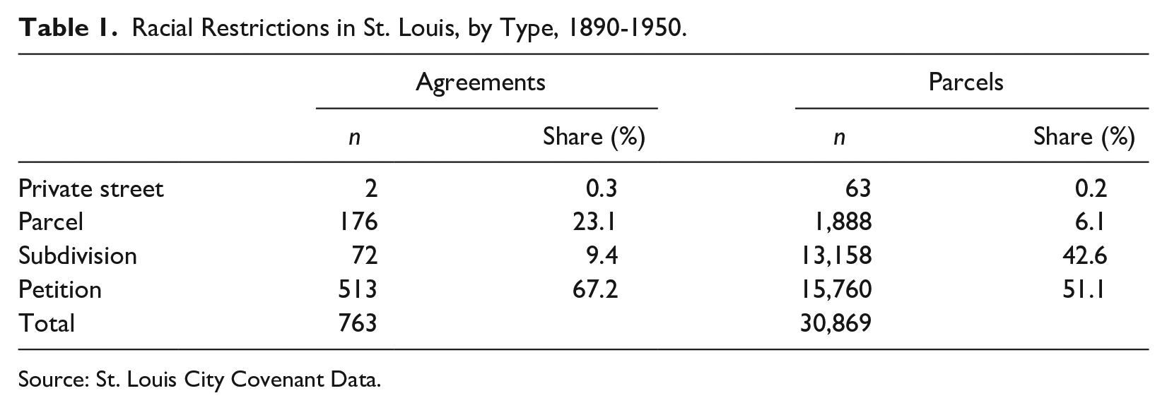
Racial restrictions in St. Louis took several forms (see Table 1). In the late nineteenth and early twentieth centuries, the City’s most exclusive neighborhoods were organized as private streets. These streets (which were not public right-of-ways) were gated, basic services were provided through local assessments, and building design and placement was carefully regulated. 14 But here, the racial restrictions were largely implicit, generated by the exclusivity of the property and not formal restrictive language. Only two of the City’s numerous private streets, West Cabanne Place (1905) and Thornby Place (1908), included explicit racial restrictions in their founding documents. While high property values and tony building standards were seen as sufficient protection in the early years of the century, such presumptions did not always last. As the City’s African American population grew, some private streets added restrictions by petition in an attempt to stem racial transition. 15
Racial Restrictions in St. Louis, by Type, 1890-1950.
Source: St. Louis City Covenant Data.
Through the first decades of the twentieth century, a number of such restrictions were attached parcel by parcel as covenants to deeds of sale. Such covenants were included in both transfers of individual parcels and (as on Minerva Avenue in 1893) in sales of blocks or partial blocks from landowners to small-scale developers. These lot-by-lot restrictions, covering 1,888 parcels by 1950, accounted for a small share (just 6.1%) of all restricted parcels and many were later absorbed by or included in larger scale subdivision or neighborhood restrictions.
Beginning in the early 1920s, a new generation of “community builders” (like Fillmore) began to develop residential subdivisions—and attach restrictions to them—on a much larger scale. 16 St. Louis Hills Estates No. 4, for example, attached restrictions to 210 new homes; the original development of St. Louis Hills in 1929 attached restrictions to just under 1,300 homes. Such subdivision restrictions often ran to twenty or thirty pages and included a careful delineation of prohibited nuisances (industrial or commercial use, vice, animals), building size, design (including design review) and materials, lot setbacks, minimum cost requirements, and design or placement criteria for fences and hedges and outbuildings. 17 The conception and marketing of such subdivisions leaned heavily on both the provision of public goods (especially modern sanitary infrastructure) and on promises of permanence and protection and exclusion. They promised stable investment, as Robert Fogelson and Paige Glotzer have argued, by calming the fears and anxieties of prospective homeowners in an era when land-use zoning and building codes were in their infancy. 18 In St. Louis, seventy-two subdivision restrictions recorded between 1890 and 1950 account for only 9.4 percent of all restrictive agreements but—due to their scale—fully 42.6 percent of all restricted parcels. These agreements often included a reversionary clause, transferring title back to the developer should the racial restriction be violated. 19
In settings (like St. Louis) where residential construction largely predated the use of racial restrictions, many of them were cobbled together—block by block—to create and sustain bright boundaries between black and white neighborhoods. These petition restrictions, usually covering a city block or the houses facing each other on a given street, were assembled by collecting signatures door to door. In St. Louis, the white realtors trade association, the St. Louis Real Estate Exchange (SLREE), was both the primary driver behind the drafting and assembly of petition restrictions, and—as a third-party signatory to most of the them—the primary enforcement mechanism as well. 20 Such agreements were primarily racial in intent 21 : the SLREE’s “uniform restriction agreement” sought to “preserve the character of said neighborhood as a desirable place of residence for persons of the Caucasian Race” holding that homeowners could not “erect, maintain, operate, or permit to be erected, maintained or operated any slaughterhouse, junk shop or rag-picking establishment” or “sell, convey, lease, or rent to a negro or negroes.” 22 Petition-based restrictions accounted for 67.2 percent of all restrictions and 51.1 percent of all restricted parcels. Of the 513 petition-based restrictions, over 90 percent (466) were sponsored by the SLREE. In turn, 134 of these petitions were renewals, most of these drafted in the 1940s, reconfirming restrictions on blocks where the original agreements (most drafted in the early 1920s) were about to expire.
The Timing of Restriction
The earliest effective restrictions were those erected by private streets, most of which were established in the late nineteenth and very early twentieth century. The decades before 1920 also saw scattered parcel-based restrictions, their location and timing largely determined by the pace of early residential subdivision and development (see Figure 2a). Across this early era, barriers to African American occupancy were stark but implicit, enforced by exclusive development (as in the private streets), common understanding, and violence. In 1914, for example, residents of Chouteau Place (a large development of over 1,300 parcels in North St. Louis) assumed that the original subdivision in 1898 barred African American occupancy, but no such restriction had been filed. Over the next two decades, such restrictions were formalized in a piecemeal fashion, either by petition or by adding racial restrictions to individual parcels at sale. 23

Racial restrictions by year and type, 1890-1950.

(a) Racial Restrictions on Property in St. Louis, 1920. (b) Racial Restrictions on Property in St. Louis, 1930. (c) Racial Restrictions on Property in St. Louis, 1940. (d) Racial Restrictions on Property in St. Louis, 1950.
Formal subdivision-based restrictions were first drafted in 1906 (Waustrath Place) and, before 1915, included three large developments in South St. Louis: Morningside Park (518 parcels), Nottingham (389), and Hadley Park (213). The only restrictions by petition before 1915 were in the 4400 block of Labadie Avenue (1910), in the 4600 block of Labadie (1911)—the restriction that included the parcel challenged in the Shelley case three decades later—and in two neighboring blocks in 1912. 24 But, after that flurry of activity, the pace of restriction slowed (see Figure 2). Between 1905 and 1911, an average of 360 parcels were restricted each year. Between 1912 and 1921, the average was only 192 parcels a year, almost all of that accounted for by a few medium-sized subdivisions platted in 1917, 1919, 1920, and 1921. In the decade after 1921, by contrast, the average annual restriction—at 2,043 parcels—was more than ten times as great.
This temporal pattern raises some interesting questions. The conventional assumption is that the diffusion of race-restrictive agreements was a response to the East St. Louis Race Riot in July 1917 25 and the Supreme Court decision in Buchanan v. Warley, which prohibited racial zoning ordinances (like the one approved by referendum in St. Louis a year earlier), in November 1917. 26 If there were a direct reaction by white homeowners or realtors to these events, one would expect to see it in petition-based restrictions, which were assembled at whim in established neighborhoods and not dependent on the timing of the sale or development of property. And yet, with the exception of a single agreement in April 1920 (renewing the 1908 restriction on the private street Thornby Place), the next restrictions by petition were not drafted and filed until early 1922—more than four years after the events of 1917.
The timing and pace of restriction (Figure 1) were shaped in part by the local experience of the Great Migration. At 43,960 (6.4% of the total population) in 1910, the African American population of St. Louis was already well established. 27 As that population grew (by 25,894 between 1910 and 1920, and by another 23,726 between 1920 and 1930), local real estate interests responded, using expansive subdivision restrictions to mark the neighborhoods south of Forest Park as indelibly white, 28 and a frantic patchwork of petition restrictions (see below) to set the north-south boundary between white and black occupancy. The focus of concern, in this respect, was the footprint of “The Ville,” the well-established African American neighborhood north of Easton Avenue between Sarah and Taylor. The Ville was the center of African American life in St. Louis, home to Sumner High School (the first high school west of the Mississippi to admit black students), Lincoln University School of Law, Homer G. Phillips Hospital, and a thriving black business and professional community. 29 The short-lived 1916 zoning ordinance circumscribed the Ville; the restrictive agreements that followed were an effort to stem its expansion as the City’s African American population grew.
While the Great Migration raised the stakes for white homeowners and developers in St. Louis, the dramatic increase in the use of restrictive agreements after 1922 was driven in large part by the self-conscious professionalization and standardization—nationally and locally—of the real estate industry. Local boards like the SLREE, networked through the National Association of Real Estate Boards (NAREB), invented and nurtured a professional fascination with “neighborhood homogeneity” and made racial occupancy—and the assumption that black occupancy destroyed property values—a staple criteria of public and private property appraisal. 30 The SLREE—and the local “improvement associations” it nurtured—was instrumental in the creation, diffusion, and enforcement of race-restrictive agreements, especially in the neighborhoods surrounding the Ville. 31
The filing of new restrictions slowed dramatically at the end of the 1920s. Part of this, of course, reflected the onset of the Great Depression and the collapse of the construction business. Nationally, new home starts fell from over five hundred thousand to under one hundred thousand between 1929 and 1933. 32 In St. Louis, the only significant new (and restricted) development between 1930 and 1939 was St. Louis Hills No. 2 (252 units) completed in 1930. The pace of restriction by petition also slowed, adding just over 3,400 parcels over the same decade, less than half the number (8,510) added by petition during the 1920s. This too reflected the turmoil in housing markets and housing finance, as well as the scope of the “circle of restriction” assembled on the north side during the 1920s.
As the economy recovered in the late 1930s, the pace of restriction picked up again. Between 1938 and 1950, another 1,939 parcels were restricted in new subdivisions—although land available for new development in the City was dwindling and the restrictions accompanying suburban development in St. Louis County were now a more important driver of local segregation. Another 4,699 parcels were restricted by petition after 1938. And, as importantly, 4,357 previously restricted parcels had those restrictions extended by 118 renewal petitions as the expiration date (most petition restrictions had a twenty-year term) of restrictions drafted in the early 1920s approached. Indeed, the war years, as Robert Weaver noted in 1948, marked “veritable fetish for maintaining and strengthening racial covenants developed in many northern cities.” 33 And all of this occurred as the Shelley case (which began with the contested purchase in 1945) wound its way through the lower courts.
The pace of restriction slowed with Supreme Court’s Shelley decision in May 1948, but did not come to a complete halt—indeed another 363 parcels were restricted in the months after the decision, including the last two phases of the sprawling St. Louis Hills development in south St. Louis. 34 Because the Court prohibited state enforcement of racial restrictions, but not the agreements themselves, many still viewed them as powerful symbols of exclusion. And, for its part, the SLREE determined to sustain restrictions, and the City’s residential color line, by other means. 35
The Geography of Restriction
The spatial distribution of restriction closely tracked both patterns of residential occupancy and the type of restriction being employed. The first marker of residential exclusion, the City’s private streets were (with the exception of Shaw Place, near the Missouri Botanical Gardens on the south side) all located in the neighborhoods immediately north and west of Forest Park. Early parcel-based restrictions were scattered across the City, most of them eventually accompanied or eclipsed by larger scale restrictions by petition or subdivision. But the dominant spatial logic of restriction was the starkly parallel development of subdivision restrictions in south St. Louis, and petition restrictions in north St. Louis. While restrictions were more widespread in some settings (most notably Chicago), in St. Louis “the number of covenants,” as one contemporary observer put it, was “less important than their strategic location.” 36
While a few subdivision restrictions were drawn up for developments along the City-County line in north St. Louis, most were clustered together in southwest St. Louis, south of the Burlington-Northern rail corridor that runs east to west from downtown alongside the River Des Peres (and, after 1965, I-44). Here, residential development was conceived and marketed as a haven from the disorder of the City. The myriad restrictions imposed on these properties protected the developer by ensuring that early purchasers would not scare away later ones and then protected all owners from their neighbors—by constraining what they could do with their property, and who could live there. Purchasers happily constrained their property rights for the promise of permanence and protection—from undesirable choices made by neighbors and from undesirable neighbors. 37
The overarching goal across south St. Louis was a uniform pattern of building placement and design, and the prohibition of nuisances enumerated in subdivision founding documents—a list which typically included commercial land use, the keeping of livestock, and occupancy by anyone not of the Caucasian race. The restrictive clause for the Cleveland Subdivision (ninety-two parcels developed in 1921 near the Botanical Gardens), for example, left little doubt as to the range of nuisances that threatened local property values: “There shall not be erected, kept or permitted on any lot or part of lot of said subdivision any slaughterhouse, stockyard, milk dairy, glue, candle or white lead factory, brewery or disorderly house or nuisance of any kind,” and then—without skipping a beat—concluded “nor shall any lot, house, building, flat or improvement of any kind or an interest therein be sold, leased, rented, conveyed, transferred, willed, devised or in any way or manner given, granted or disposed of or occupied by any persons other than those of the Caucasian Race.” 38
While subdivision restrictions in south St. Louis created aspirational pockets of exclusion, the spread of petition-based covenants on the north side was much more frantic and defensive. Here, covenants were largely assembled in or near transitional neighborhoods as an effort to slow or halt expansion of African American occupancy north and west from the Ville.
39
The initial effort to seal the northern boundary of the Ville, as we have seen, came with restrictions in the 4400 and 4600 blocks of the Labadie in 1910 and 1911. The latter, which would eventually become the centerpiece of the Shelley case, held that said property is hereby restricted to the use and occupancy, for the term of Fifty (50) years from this date . . . That hereafter no part of said property or any portion thereof shall be, for said term of 50 years, occupied by any persons not of the Caucasian Race; it being intended only to restrict the use of said property for said period of time against the occupancy by owners or tenants of any portion of said property for resident or other purposes by people of the negro or Mongolian race.
40
Sixty-two of sixty-seven property owners signed the agreement. In 1922, the restrictions on Labadie were reaffirmed using the SLREE’s uniform restriction agreement; among the new signatories was the eventual Shelley plaintiff Peter Kraemer. 41
The ragged circle of restriction was pulled tighter during the 1920s. In 1922 and 1923 alone, the SLREE sponsored over one hundred restrictive agreements encompassing almost 4,700 parcels to the north, south, east, and west of the Ville. By 1945, these restrictions included almost all of the residential property from St. Louis Avenue north to O’Fallon Park, from Newstead Avenue west to Kingshighway, and from Vandeventer Avenue east to Grand Avenue. To the south, one band of restriction ran east to west along Delmar, and another just south of the private street Westminster Place. In these neighborhoods, the fear addressed by protections or restrictions was much more immediate and tangible. The SLREE and its allies pointed to the imminent threat of racial transition, and indeed, many petitions (as on Labadie Avenue in 1911) were assembled on blocks where African American occupancy was already established.
In these neighborhoods, in turn, the constraint on property rights was more contentious. Petition-based covenants were haphazardly and imperfectly assembled and enforced. Their coverage was incomplete, and some struggled to maintain the threshold of signatures (75% of property owners) needed to remain valid. In this uncertain climate, some owners refused to sign when the SLREE or local improvement association arrived at the door with petitions in hand. And some who had signed, once it became apparent that the “protection” might be insufficient, looked for a way out. Formally removing the restrictions was uncommon: only five restrictions were actually rescinded by the original subscribers. 42 Others challenged the petitions that they (or their predecessor in ownership) had signed on the grounds that the original agreements were faulty, or that—having failed in their purpose—should be discarded. 43
Indeed, the first legal challenges to racial restrictions in St. Louis were not filed on equal protection grounds, but by white homeowners in these contested and transitional neighborhoods who wanted to sell unconstrained and join the flight to the suburbs. In 1923, Emma Pickel signed a restrictive agreement covering the south side of Finney Avenue between Krum and Spring—only to see her neighbors (and cosigners) ignore and abandon the agreement over the next few years. “If I look out my back window I see negroes, and the front door it is negroes,” as Pickel testified in 1930, “I am tied up in my own house.” The SLREE tried to force Pickel to honor the restriction, but the Missouri Supreme Court held that she and her neighbors were “living under the very conditions and surroundings against which the proposed covenant was to protect them” and upheld a lower court decision voiding the restriction. A 1924 restriction on Vine Grove Avenue between Ashland and Labadie covered forty-six parcels, but only eleven of the property owners signed. When, amidst substantial racial transition, the SLREE moved to enforce the restriction in 1938, the St. Louis Court of Appeals denied the suit on the grounds that the “neighborhood scheme” of restriction had failed in both its conception and its effect. 44
While some restrictions failed, and the Courts began to chip away at their legality, their impact was starkly apparent. Taken together, these types and geographies of racial restriction fundamentally shaped both the pace and character of residential development and the housing options faced by white and black homeowners and renters—especially through the peak years of the Great Migration to St. Louis. The universe of single and two-family residential parcels in St. Louis at the 1940 census was just under one hundred thousand. 45 By the end of the 1940s, parcel, subdivision, and petition restrictions—encompassing 30,954 parcels (see Figure 3)—prohibited African American ownership or occupancy on about a third of the City’s residential property base.

Racial restrictions, cumulative coverage, 1893-1950.
Segregation
The scope, timing, and geography of racial restrictions, in turn, were the primary mechanisms driving black–white residential segregation in the urban north—which increased dramatically in most settings between 1890 and 1940, and then leveled off. 46 The measure of segregation is captured in different ways by different indices, all of which measure the difference between the demographic distribution in a given whole (a city or a metropolitan area) with the demographic distribution in a part of that whole (a ward, a census tract, a neighborhood). 47 Here, I employ the dissimilarity index, which measures segregation between groups as the share of one of those groups that would have to the move to accomplish equal distribution, and the isolation index, which measures the percentage of the same-group population that lives in the part (ward, tract, enumeration district) where the average member of that group lives. As both measures suggest, the scale of the part (a city ward, a census tract, an enumeration district) affects the level of segregation, but—regardless the measure used—the trend is unmistakable.
In St. Louis, both the black–white dissimilarity index (Figure 4) and the black–white isolation index (Figure 5) show the same pattern: a dramatic increase in segregation from 1910-1950, running parallel to the increased use of race-restrictive covenants. In St. Louis and elsewhere, as Massey and Denton conclude, “by 1930, the perimeters of black settlement were well-established in most cities and the level of black-white residential dissimilarity had reached a stable and very high level.” 48

Black–white dissimilarity index for St. Louis, 1880-2000.

Black–white isolation index for St. Louis, 1880-2000.

HOLC ratings and restricted parcels, 1937.
The conclusion here is pretty clear: while public policies such as zoning, subsidies for suburban development, and neighborhood redlining may have sanctioned and sustained residential segregation, they did not invent it. That dubious credit goes to deed-based racial restrictions, and their enforcement through a combination of legal sanction and local violence and intimidation.
Replication, Emulation, and Adaptation
The spread of racial restrictions in the first half of the twentieth century was in part a pattern of replication and emulation—from single sales (parcels) to larger scale subdivision and petition-based restrictions, from city to city through the NAREB and other professional networks, from one development to the next in south St. Louis, from one block to the next in north St. Louis. In turn, the spatial inequality created by these private restrictions has been—before and since the Shelley decision—replicated, emulated, adapted, and institutionalized by other means and by other actors. In this respect, the initial segregation was accomplished by the exclusion or opportunity-hoarding best represented by subdivision restrictions, and the exploitation or subordination best represented by petition restrictions. These root inequalities, in turn, were enforced through both violence and social norms, emulated and extended by other private mechanisms (such as private appraisal standards), leveraged into other arenas (such as neighborhood schools), institutionalized and entrenched by public polices (such as land-use zoning), and cemented by both psychological processes (especially the assumptions about the relationship between housing value and black occupancy), and ongoing exploitation or discrimination. 49
Perhaps most importantly, the restrictive covenant was but one arrow in the quiver of local realty interests—whose well-documented discriminatory assumptions and practices provided ample opportunity to exclude or steer African American buyers or renters from white neighborhoods. 50 Indeed, the officers of the SLREE were disappointed but not discouraged by the Shelley decision and responded to the Court’s decision by announcing their willingness to continue enforcing existing agreements and restrictions, and reinforcing the Exchange’s longstanding rule “that no realtor may sell to Negroes, or finance any transaction involving the purchase by a Negro . . . outside of the established unrestricted districts.” 51
Another mechanism of replication and adaptation was private appraisal. Realtors, lenders, and insurers embraced the assumption that black occupancy threatened property values, and dutifully incorporated “negro encroachment” and “presence of deed restrictions” into their assessment and valuation of property. Indeed, restrictions were a key metric in the private appraisal and assessment of property, inflating values in “protected” neighborhoods and discounting them where restrictions were absent or soon to expire. In important respects, they both invented and sustained the conviction that African American occupancy (or even proximity) threatened property values. Over time, as Clarissa Hayward has suggested, the narratives constructed by realtors, developers, and other local interests “linked the physical deterioration of the central city, not to the age of its housing stock, or to overcrowding, or to dearth of resources for renovation or repair, but rather to the race of its new inhabitants.” 52 The standard appraisal form used in St. Louis into the 1950s included fields for “racial influence,” “% negro population,” “nearby adverse influence,” and “encroachments”—the latter commonly listing “colored people” or the distance to the nearest “negro colony.” The forms also specified any constraints or regulations affecting land use, noting approvingly both single-family residential zoning and the presence of deed restrictions. 53
Private appraisal and its assumptions, in turn, were imported into the infamous “residential security” maps drafted in the late 1930s and early 1940s by the Home Owners’ Loan Corporation (HOLC). These early snapshots of “redlining” represented both an emulation and adaptation of private practices (the same realty interests responsible for racial restrictions were responsible for the HOLC’s ratings) and an institutionalization of them by public policy. 54 The HOLC and its successor programs in the Federal Housing Agency gave their highest ratings to urban and suburban neighborhoods protected by restrictions and “redlined” those in which restrictions were never filed, or in which restrictions were expiring. The first run of HOLC loans (1933-1935) went to black and white borrowers alike, but hewed closely to racial boundaries established by private restrictions and cemented existing patterns of segregation. 55 The Federal Housing Administration’s (FHA) infamous Underwriting Manual echoed and sustained the logic of private restrictions, warning against the presence of “incompatible racial and social groups” and threat to property values when neighborhoods were “invaded by such groups.” 56
In St. Louis, the relationship between private restriction and HOLC ratings reflected the two spatial logics of restriction: subdivisions on the south side and petitions on the north. On the south side, HOLC ratings corresponded closely with the geography of restriction. In 1937 (Figure 6), the HOLC “A” grades almost perfectly replicate the footprint of restricted subdivisions, especially in and around the St. Louis Hills developments. Where the HOLC granted an “A” rating in the absence of formal restrictions (as in the neighborhoods immediately north of Forest Park), it leaned on either the exclusiveness of the neighborhood or the presence of racial restrictions nearby. In the 1940 revision to the ratings for St. Louis (Figure 7), this pattern was essentially similar, although, in many neighborhoods, the HOLC downgraded the 1937 “A” areas to “B” and the adjoining 1937 “B” areas to “C.” Indeed, we see in the 1940 ratings a distinct pessimism creeping in as to the long-term prospects for restriction and exclusion. “Zoning and restrictions still apply,” as the HOLC noted of one 1937 “A” neighborhood south of Forest Park that it was bumping down to “B” three years later, “but transition evident in neighboring areas is taking effect,” noting a “gradual shifting of population in this neighborhood, the original owners moving westward and out of the city.” 57

HOLC ratings and restricted parcels, 1940.
On the north side, however, the HOLC appraised racial restrictions quite differently. In their area descriptions, the HOLC took note of the exactly the same elements that animated the patchwork of petition restrictions: mixed occupancy, and racial transition at the borders of the Ville. In 1937 (Figure 6), the Ville itself received a “D” grade, the bordering neighborhoods were graded “C,” and the neighborhoods north of St. Louis Avenue and west of Kingshighway were graded “B.” In 1940 (Figure 7), virtually all of the “B” districts north of Delmar were downgraded to “C.” In their narrative descriptions, the HOLC often attributed these ratings to a combination of housing quality and black encroachment: “There is not much hope for betterment,” as the HOLC concluded for a district near Grand and Cass, “as this district is flanked on all sides by Negro, slum and blighted communities.” 58 But, for the HOLC, black occupancy alone was enough to earn a “D” rating: “Large brick and better appearing homes are found along Enright and Taylor to Sarah Ave.,” noted the surveyors of one “D” district, “but occupied by colored people.” 59
This pattern—by which subdivision restrictions yield “protection” in south St. Louis, while petition-based restrictions mark uncertainty and transition in north St. Louis—is also captured in the count of restricted parcels by HOLC grade. Of the parcels restricted by subdivision (Table 2), fully 92.3 percent were graded “A” or “B” by HOLC in 1937. For the parcels restricted by petition, that share falls to 42.1 percent. The relationship between anxieties over racial transition and plummeting appraisals is underscored by the HOLC scoring of those parcels on which original restrictions were renewed. The HOLC extended “A” or a “B” grades to 33.9 percent of first renewals, and only 11.7 percent of second renewals (parcels subject to three efforts at restriction over this era).
Restricted Parcels, by Type, HOLC Grade (1937), and Vacancy (2002).
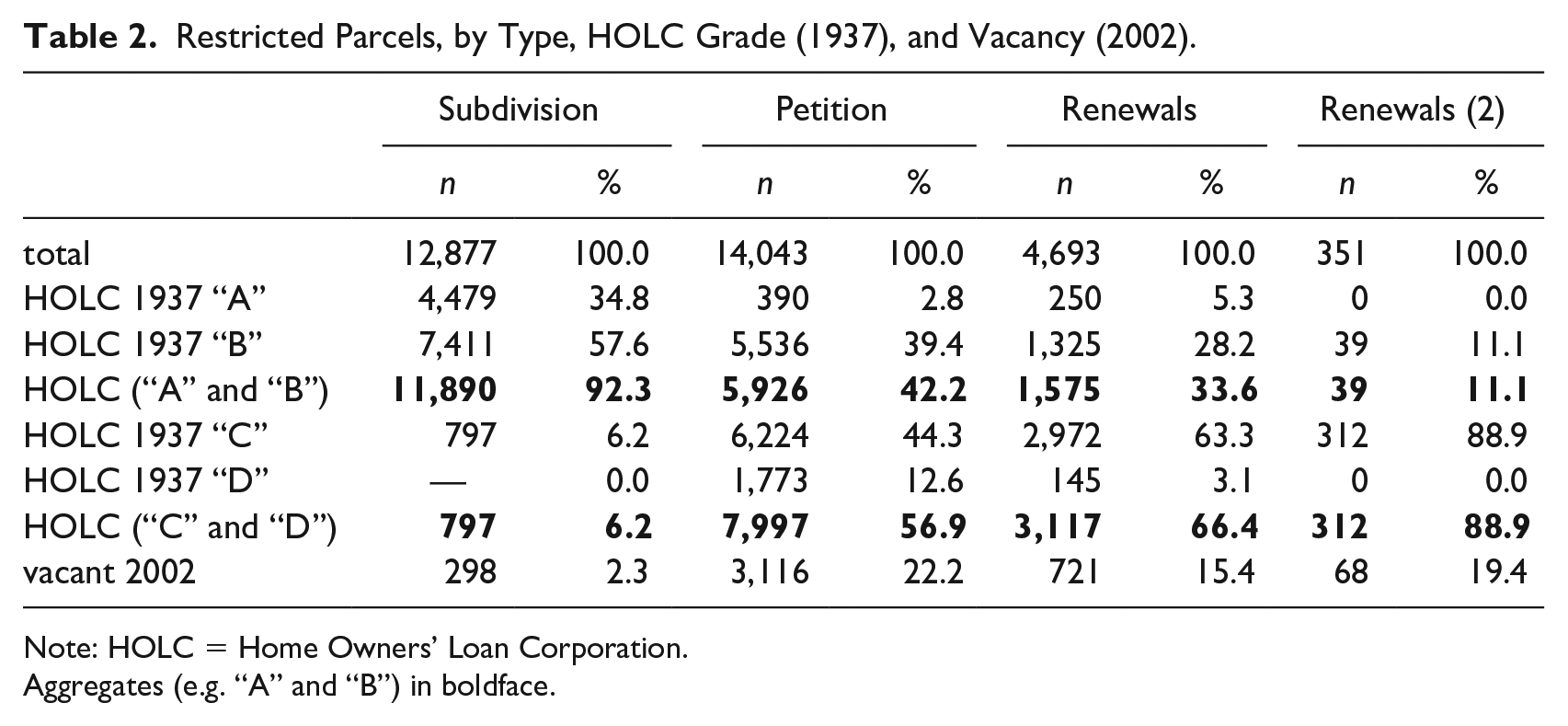
Note: HOLC = Home Owners’ Loan Corporation.
Aggregates (e.g. “A” and “B”) in boldface.
Municipal zoning, in St. Louis and its suburbs, was often animated by a determination to sustain residential segregation by other means. In St. Louis, of course, the City’s first zoning law was the racial zoning ordinance passed by referendum in 1916. The City’s conventional zone plans of 1918 and 1925 quite candidly use private streets and subdivision-based racial restrictions as guide to the location of the most exclusive “first residence” districts. “In practically all cases,” as City Engineer Harland Bartholomew conceded, “the first residence districts are areas that have restriction in the deeds,” adding that exclusive zoning was intended as insurance “against the day when private restrictions expire.” 60 This was the general pattern on the south side (Figure 8), where “first residence” districts tracked the geography of racial restrictions. On the north side, again, the logic of emulation and adaptation was quite different. As with the HOLC, restrictions north of Delmar were seen not as sources of protection or exclusion, but as markers of threat and racial transition. Over the course of the 1920s and 1930s, City planners systematically underzoned north side neighborhoods, allowing commercial, industrial, and multifamily zoning to displace land set aside for single families. Residential zoning, which was only fully implemented after most of the City had been developed, was shaped as much by patterns of racial occupancy and racial restriction as it was by existing land use or housing stock. After Shelley, local elected officials and local planners in the St. Louis suburbs quite candidly viewed the strategy of patchwork municipal incorporation and exclusive, large-lot, single-family zoning as the logical successor to private restrictions. 61

1925 zone plan restricted parcels.
Alongside municipal zoning and the public and private elaboration of redlining, racial restrictions—and the segregation they created—were replicated in, and extended by, a wide array of institutions and policies. The organization of schools reflected and reinforced local patterns of exclusion and segregation. 62 Urban renewal policies and code enforcement policies layered the designation of “blight” over other metrics and mechanisms for distinguishing between good neighborhoods and bad. 63 And policing, in St. Louis and its suburbs, was animated largely by the desire to regulate the boundaries between white and black neighborhoods, and to discipline or sanction those deemed out of place. 64
Finally, the architecture of racial restriction was instrumental in codifying, formalizing, and normalizing the very idea that black occupancy was a “nuisance” or “blight” that threatened property values. “As categorical inequality spreads,” Elizabeth Anderson notes, “people explain and legitimate it by telling stories about supposed inherent differences between their groups.” 65 Narratives employed by realtors, developers, and neighborhood improvement associations not only justified exclusion on such grounds but then drew ironclad connections between the condition of the overcrowded spaces left behind and the race of their inhabitants. 66 In their classic 1945 study of Chicago, Horace Cayton and St. Clair Drake observed that “the pattern of residential segregation results in habits of thought which characterize certain parts of the city as ‘white’ and others as ‘Negro.’” 67
The St. Louis restrictions shed light on the ways in which white Americans thought about race and property. It is remarkable, in this respect, not just that stakeholders (realtors, developers, neighborhood associations) engaged in such a sustained effort to enforce segregation but that, between 1911 and 1950, over sixteen thousand white St. Louis homeowners in north St. Louis signed petitions prohibiting African American occupancy in their neighborhoods. And it is remarkable that such assumptions and modes of thought proved so tenacious. Although now unenforceable, race restrictions live on in land records and residential deeds; these “singularly unpleasant ghosts of the past” sending powerful signals about good neighborhoods and bad, and about the threat of racial transition to property values. 68 In turn, prospective homeowners or renters, as Maria Krysan and Kyle Crowder suggest, garner and process information about neighborhoods and housing options in such a way that rarely challenges—and routinely reinforces—existing patterns of segregation. 69
Conclusion: Impacts and Importance
The extension and adaptation of private racial restrictions by other policies and other institutions, in turn, ensured that their impact—on American cities and their residents—would be lasting as well. Segregation is “a principal cause of group inequality,” as Anderson reminds us, “It isolates disadvantaged groups from access to public and private resources, from sources of human and cultural capital, and from the social networks that govern access to jobs, business connections, and political influence. It depresses their ability to accumulate wealth and gain access to credit. It reinforces stigmatizing stereotypes about the disadvantaged that cause discrimination.” 70
The starkest marker of such disinvestment and isolation was the dramatic demographic transformation of North St. Louis, and especially those neighborhoods so frantically “protected” by the SLREE and others since the early 1920s. After World War II (and especially after the Shelley decision in 1948), those neighborhoods—now “unprotected” against “Negro invasion”—experienced white flight and racial transition. In the short run, white homeowners and tenants were replaced by black homeowners and tenants. In the census tracts north and west of the Ville, the white population fell by over 80 percent between 1930 and 1970, from 236,677 to 38,610, while the black population grew from 5,208 to 114,254. In the long run, virtually all of the white residents fled, and the overall population plummeted: by 2010, the population of these tracts (80,334) was less than third what it been in 1950, and the white population accounted for just over 2 percent of that total. 71
Restrictions, in this sense, were important when they worked but also when they failed—and rapid racial transition, falling property values, and neighborhood disinvestment and decline followed in their wake. 72 In a sense, the idea that black occupancy destroyed property values became a self-fulfilling conviction. “Whites sharply constrained black residency and homeownership,” as Hayward notes, “and then racialized those failures—citing low rates of homeownership or the conditions in necessarily overcrowded black neighborhoods as evidence for the black threat to neighborhoods and property values.” 73 Black homeowners, initially excluded from neighborhoods altogether, then filtered into them—often on predatory terms—as property values collapsed. The stark and sustained gap in racial wealth, in this respect, is a direct legacy of racial restrictions and the segregation they created. 74 In St. Louis, housing values were largely sustained in south side subdivisions, but fell precipitously in north side neighborhoods. Indeed, nearly a quarter of the parcels covered by petition-based covenants (Table 2) were abandoned and vacated by 2002.
Finally, the importance and impact of this segregation rests not just on spatial isolation itself but also on the stark and lasting “neighborhood effects” that came with sorting a local population by race and class. Disparate access to housing, in the American context, also meant disparate access to public goods—especially schools—that followed residential patterns and were financed by local property taxes. 75 It meant disparate access to public goods—sewers, streets, potable water—that were increasingly provided and paid for through private residential development and private housing investments. 76 The racialization of space, as Charles Mills observes bluntly, marked “the geographic boundary of the state’s full obligations.” 77 And it meant disparate access to private goods—including retail and employment—that accompanied wealthy neighborhoods and avoided poor ones. Racial covenants—and the segregation they invented and sustained—did not just curtail housing options; they curtailed opportunity. 78
Footnotes
Declaration of Conflicting Interests
The author(s) declared no potential conflicts of interest with respect to the research, authorship, and/or publication of this article.
Funding
The author(s) disclosed receipt of the following financial support for the research, authorship, and/or publication of this article: Research in the St. Louis Deed Records was supported by St. Louis REALTORS, Eastern St. Louis Legal Services, The Metropolitan St. Louis Equal Housing and Opportunity Council, and Harvard University’s Commonwealth Project.
