
Abstract
The article approaches the dynamic condition of the urban form and activities of the so-called “urban thresholds,” spaces located in between different city fabrics. The study is based on a comparative analysis of seven maps representing key historical moments of Porta Ticinese’s area in Milano from 1807 to 2022, produced through geographical information system-based reconstruction techniques of original cartographies. The article discusses and provides graphic analysis of how time influences the spatial form of these spaces and the character of the activities, highlighting the strong correlation between them. The research explains how the geometry is in a constant process of consolidation, and how the activities, despite being different in each period, tend to share a similar character linked to formal or ephemeral transaction areas both at the metropolitan scale and local scale. The article concludes with a description of these spaces as eloquent examples of a unique “interstitial urbanity.”
Introduction
One of the most vibrant spaces of the Italian city of Milano are the so-called “Porte Milanese,” the historic gates located at the medieval and Spanish walls of the city. These prominent landmarks are still today working as strategic accesses to the urban inner core, and, therefore, areas with a high confluence of people, goods, and vehicles and historical, geographical, or collective imaginaries. Porta Romana, Porta Vittoria, Porta Venezia, Porta Nuova, Porta Garibaldi, Porta Tenaglia, Porta Sempione, Porta Vercellina, Porta Ticinese, Porta Lodovica, and Porta Vigentina are some of the most renowned “porte” in the urban geography of Milano (see Figure 1).
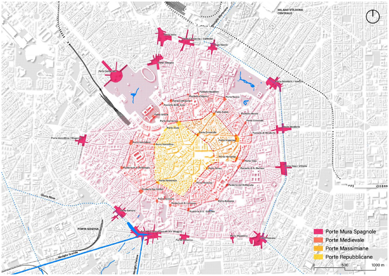
Map of the city of Milano with the location of the “Porte” (gates) and “Pusterle” (secondary gates) organized into four groups: the “Porte Repubblicane,” the “Porte Massimiane,” the “Porte Medievale,” and the “Porte Mura Spagnole” on the Spanish walls. Blue color represents the main water features of the city.
However, these are not an exclusive phenomenon of the city of Milano, but rather a type of public spaces found in cities built over time, and more specifically, present in all those that dismantled their walls to promote urban expansion since the nineteenth century. Well-known places such as the AlexanderPlatz or PotsdamerPlatz in Berlin, the Slussen in Stockholm, Hofplein in Rotterdam, Schottentor in Vienna, Place de la République in Paris, or Norreport in Copenhagen—among many others—were formerly gates and today they are still meaningful urban accesses to the inner city. These kinds of urban spaces might be called “urban thresholds,” as they work as spatial interfaces or gateways linking the core of the city and the outer districts.
Despite being commonly called urban squares in most of the city catalogs or citizen’s imagination, they are diverse from a canonical interpretation of a square as a central place, geometrically well defined, a place of representation often preceding landmark buildings, and with a unique character. 1 These have been historically marketplaces (informal or formal), enclaves with custom houses and control points, areas of ephemeral activities and interchange, spaces with irregular geometries, and diverse assemblages of architectures. And second, it is worth mentioning that they have a high degree of change in the form and activities, the geometry, and the uses. That might lead to initially designating them as “dynamic urban thresholds.” Although this dynamic condition is not exclusive to these urban spaces—the city itself is a living and changing entity—the hypothesis is that these are places with a higher degree of variation in shape and with an everchanging activity. 2
The analysis of this type of space has not been at the forefront of the historiographical studies of urban space. Camillo Sitte’s well-known work, for instance, does not address the study of these places, focusing more on the analysis of certain medieval squares mainly located within the urban fabric. 3 In addition, he does not primarily focus on the historical factors that led to these forms; instead, his analysis is more focused on aesthetic sensitivity. Other classic works, like Albert E. Brinckmann’s, 4 Paul Zucker’s, 5 or Anthony E. J. Morris’s, 6 deploy a historiographical description of the evolution of some public spaces, but not approaching the dynamic evolution of these areas in particular. In turn, Joseph Stübben’s renowned monograph Der Städtebau 7 partially mentions these places when introducing “city gates” (Stadtthorplätze) as singular monuments in some squares, describing some urban thresholds such as Holbeinplatz (Basel) as “traffic squares” (Verkehrsplätze), or explaining the phenomenon of the conversion of ancient walls into boulevards.
Edmund Bacon’s Design of Cities 8 introduces some urban thresholds like the Place Stanislas, Place de la Carrière, and Place d’Alliance in Nancy, and also develops an evolutionary interpretation of urban squares such as the Piazza del Campidoglio in Rome or Piazza della Santissima Annunziata in Florence. This approach is relevant to our article, as it provides a way for analyzing the aforementioned “dynamic” condition detected in these spaces. Other recent research has also been using this diachronic analysis of public spaces to evaluate, for instance, Washington Square in New York, 9 Attaba Square in El Cairo, 10 Slussen in Stockholm, 11 or the Market and the Senate Square in Helsinki, 12 among many others.
The concept of “thresholds” has been also approached from other perspectives and scales. This is the case of Dovey and Wood discussing what they call “urban interfaces” as the socio-spatial assemblage at the scale of public–private division, 13 the analysis by Kris Scheerlinck on the “depths configurations” in the interplay between interior and exterior in collective housing projects, 14 or the study by Eulàlia Gómez-Escoda of the impact of ground-floor activities into the urban landscape. 15 In these works, thresholds are not considered merely as lines but as in-between spaces promoting interaction between the public, the private, and the collective sphere. Using Aldo van Eyck’s vocabulary, thresholds might be understood as the expression of “twin-phenomena,” 16 moving from the simple duality discussed by modernist architecture to highlighting the “in-between” as a key space between two entities. 17 This recalls the term “interstice,” which etymologically stands for the idea of being between two entities. 18
The “in-between” condition is the essence of urban thresholds, a matter that has been widely explored from multiple perspectives. Paola Pittaluga’s contribution 19 provides a thorough review of this phenomenon in urban studies. Among them, she recalls the term “terrain vague” which is relevant to evaluate some moments of the history of the urban thresholds as vast spaces in front of city gates and hosting ephemeral activities. 20 The text also deepens into the concept of “third spaces” in language communication used by Homi Bhabha 21 or by Edward Soja 22 to explain the “temporary autonomous zone” which is created in “liminal” spaces. 23 Transition spaces are also key spaces in ecology, as described by the idea of a “third landscape” 24 or “fringes,” 25 which points to the understanding of transition spaces as ecotones26,27 or urban edge. Paola Pittaluga finally declares that “in-betweenness” implies “flexibility,” “spontaneous processes,” “diversity,” and “hybridization” concepts which are expressed not only in the activities but also impacting the urban form of urban thresholds.
As a conclusion of these approaches, it must be acknowledged that “urban thresholds” in particular are not just spatial links between two parts of the city, but also a scenario for particular kinds of activities 28 and spaces marked by a high level of change. This dynamic condition is expressed not only in the change of the shape of those spaces but also in the constant shifting of activities. However, the hypothesis is that, despite this changeable identity, the essential character of these activities remains unaltered over the years, a feature that has barely been addressed in previous studies.
In the aforementioned case of Porta Ticinese (currently called Piazzale XXIV Maggio), this hypothesis is especially pertinent as today, although the place is a bustling space at all hours, the area has been recently linked with the outburst of a vibrant nightlife (the so-called movida serale), the allocation of multiple ephemeral stalls, and the consolidation of a cluster of bars, pubs, and restaurants. This situation has been often regarded by local inhabitants and the local press as a conflictive urban situation, marked by constant uncivil behaviors and a tense relationship between local authorities and the social appropriation of this space at the edge of Milano’s historical center. 29 However, the current social appropriation of the area during the night might be regarded not only as the crystallization of a certain social understanding of the public realm but also as a logical consequence of a given urban form, and a déjà vu of previous historical activities. The article aims to provide evidence of how this “dynamic” condition of “urban thresholds” is manifested through the historiographical analysis of Porta Ticinese’s area from 1807 to 2022.
Porta Ticinese as an Eloquent “Urban Threshold”: Previous Research and Analytical Methods
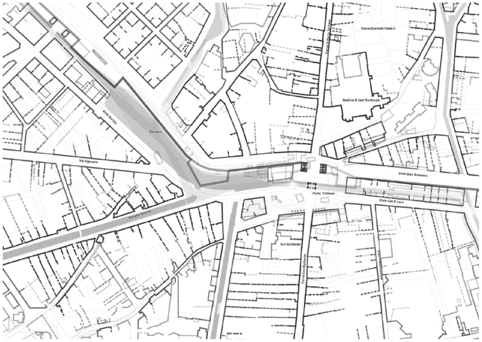
Both the medieval Porta Ticinese built in XII and the Porta Ticinese founded in XVI as a gate of the Spanish walls (Piazzale XXIV Maggio) represent a milestone in the history of Milano. 30 Most relevant and complete urban studies published on the evolution of the city point directly or indirectly to that place as a strategic gate of the city, a harbor or darsena belonging to the Navigli canal systems, a node of transit close to Porta Genova train station, and a living district bound up with leisure and fashion sectors. 31 The place, marked by a prominent situation regarding the open land of southern Lombardy (toward the Ticino river), has been a relevant object of discussion in the multiple urban plans of the city developed since the beginning of the nineteenth century 32 (Figure 2).
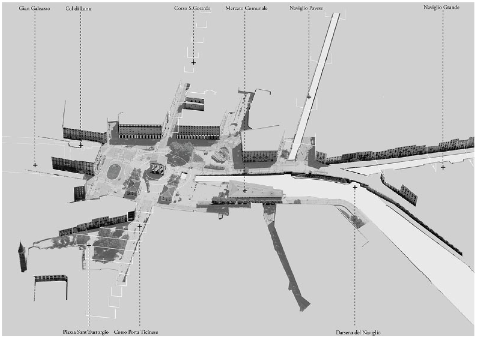
Aerial view of Porta Ticinese (Piazzale XXIV Maggio) and the Darsena in 2022.
However, as it is commonly described in the aforementioned bibliography, Milano developed a complex construction of water canals from the twelfth to the twentieth century. Although today the Canale or Navigli are only recognizable within the area of Porta Ticinese and in some parts of the northern periphery of Milano, a complex system of shipping and irrigation canals structured the city until 1929. 33 Milano sewage and irrigation system was carefully designed and used until the partial dismantling following complaints of bad health conditions and the urgency to ease the car traffic within the city. 34 Today, political and citizen engagement such as the Istituto per i Navigli, the Associazione Riaprire i Navigli, and the recent call for an international architecture competition “Milan Navigli Canal Challenge” (2022) is raising the relevance of a reopening of the ancient canals through the city center. This vindication is also well described on the website of those institutions, in regular conferences, debates, and publications. 35
The relevance of Porta Ticinese in Milano is described in a third group of literature specifically focusing on the study of this place. Here it is worth highlighting historiographic approaches to the activities carried out along the Naviglio Grande, 36 the collection of biographical experiences in this area, 37 or a more thorough study of the historical evolution of the Darsena. 38
However, although these works are valuable points of departure to the scope of this article, they just offer a general framework for the understanding of the case or a very partial understanding of some of the elements that have been shaping this space. No thorough holistic interpretation of this place has still been produced.
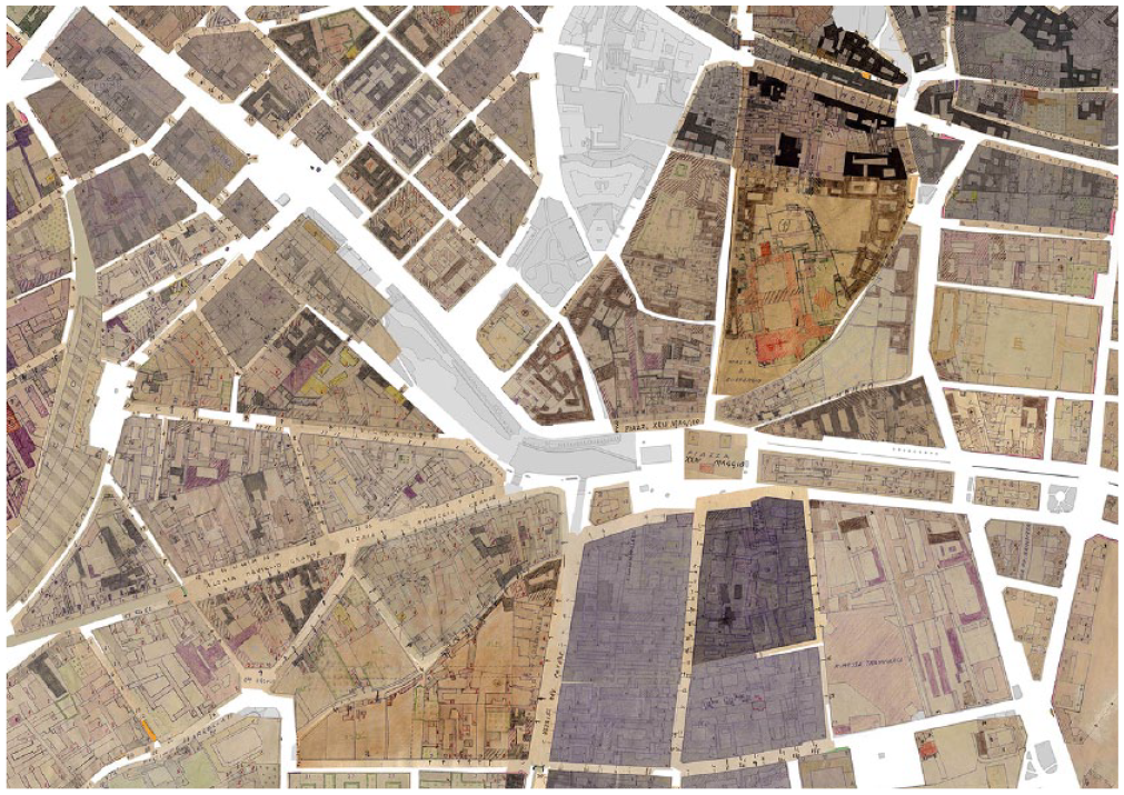
To address the study of the evolution of the space and activities in Porta Ticinese’s area, the research is based on the interpretation and comparison of a sequence of seven maps (Figure 3) representing key historical moments: (1) the foundation as a gate of the Spanish walls (using Giacomo Pinchetti’s Città di Milano, 1801); (2) the new construction of the new commemorative arch of Porta Marengo—today Porta Ticinese—by architect Luigi Cagnola (using the Piano di Astronomi di Brera, 1814); (3) the consolidation of the place as Piazza del Mercato (market square; according to the Pianta della Città di Milano, 1884); (4) the decades during the demolition of the walls (Pianta di Milano coll’indicazione del Piano Regolatore Edilizio e di Ampliamento, 1910); (5) the transformation processes derived from the Second World War (Censimento, 1946); (6) its consolidation as a traffic node (using digital cartography of Milano, 2012); and, finally, (7) the current situation considering Porta Ticinese as a living public space (updated digital cartography of Milano, 2022).
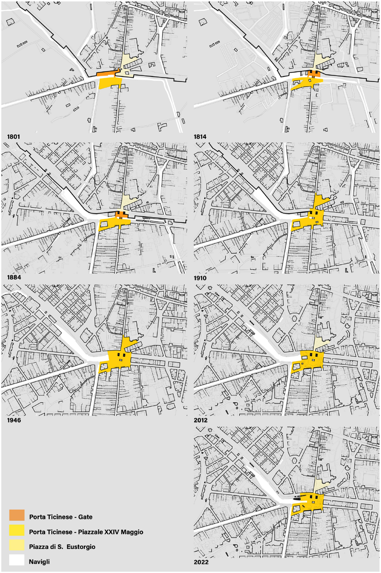
Evolution of the Porta Ticinese’s area (Piazzale XXIV Maggio) from 1801 to 2022.
These new cartographies are the result of a thorough redrawing of historical maps of Porta Ticinese and surrounding urban tissues. The redrawing process has been based on geographical information system (GIS) historical reconstruction techniques 39 but is now applied to the scale of a specific urban space, which implies a higher level of resolution and contrast with bibliographic descriptions. First, a selection of digitalized historical cartographies has been geolocalized using the QGIS software toolkit (Raster Georeferencer), using key reference points in each map. Second, a manual redrawing of each map has been developed by comparing geometries from the most recent digital cartography available at the Geoportale Comune di Milano (2012). This comparative method has been especially helpful in providing a rigorous digital drawing of most ancient maps, taking into account that minor changes, absences, or imprecisions might occur in these maps or the process of digitalization. The information on these maps has been also crossed with insights coming from the literature review on Porta Ticinese and the historical evolution of the city of Milano. Other complementary documents such as paintings, engravings, additional maps, descriptions, photographs, or satellite images have been used to confirm some elements of the evolution of the place in each phase.
The result of this process is a georeferenced atlas where each map is structured in several layers: (1) building facades, (2) partition walls, (3) courtyards, (4) roads and streets, (5) fences, and (6) water features (channels, riverbanks, and streams). These cartographic data have been further complemented with additional georeferenced data coming from (1) demographic and social data from the Censimento or Census Data from Milano in 1946; (2) urban data of ground-floor activities and pedestrian movement; and (3) visibility graph analysis using isovist computation software (isovists.org).
The first group of data consists of a handwritten database made of a single drawing per block and an associated table with data on construction date, use, and demography. These data, published at the Geoportale of Milano, have been now digitalized and georeferenced in a single GIS-based map, thus allowing comparison with other information. The second database includes data on ground-floor activities manually retrieved from points of interest of Google Maps in December 2022 (categorized into two classes: restaurants/cafés/food premises and other premises) and the geolocation of outdoor terraces (both ordinary terraces registered by the Unità Occupazione Suolo e Sottosuolo Pubblico and Area Pubblicità e Occupazione Suolo and the extraordinary licenses registered after the pandemic restrictions in 2019 and 2020 40 ). The database also includes the geolocation of Flickr photographs published until 2019 and the traces of 223 Wikiloc pedestrian routes tracked by users in the analyzed area. These data have been geolocated using the WGS84 UTM Zone 32N coordinate system, cleaned, and overlapped to generate interpretative maps of the use of Porta Ticinese’s area in the last months.
Finally, the third database provides accessibility parameters for each point of the surface of Porta Ticinese’s area, using the results of a stochastic aggregation of multiple “isovists.” Isovists represent “the set of all points visible from a given vantage point in space” according to Michael Benedikt’s pioneer article. 41 The integration of the geometric attributes of these elements allows modeling visibility graphs 42 and calculating them using software such as Depthmap 43 or, more recently, isovists.org. 44 This approach and software enable the construction of high-resolution accessibility maps, making evidence on the most visible points, potential routes, or less integrated areas. Although the use of this technique has been especially relevant in indoor studies such as museums and galleries, 45 working environments and hospitals, 46 or study dwelling typologies, 47 the use of this methodology to analyze open urban spaces is receiving more attention. 48 These studies make evident geometric attributes of a given spatial geometry, those becoming especially relevant for comparing multiple room configurations.
A Spatio-Temporal Reading of Porta Ticinese through Historical and Cartographic Analysis
In the following lines, a chronological description of the evolution of the urban form and activities of Porta Ticinese’s area in Milano is presented (Figure 3).
1801: Porta Ticinese, a Skewed Entry to the City
The first map of the analytical sequence is based on the original cartography drawn by geographer G. Pinchetti, which also included G. Antolini’s 1801 Foro Bonaparte project. The map gives a clear view of the city of Milano’s double system of walls, including the outer one—the Spanish wall—where a new Porta Ticinese (previously known as Porta Ciccia and Porta Marengo) was built as an external homothety of its homonymous in the inner medieval walls. At that time, the outer Porta Ticinese worked as a defensive gate of the city and its spatial configuration followed the military requirements for controlling access. The gate is hidden behind a prominent bastion, which provokes a lateral passageway to the city. A narrow bridge crosses the water canal—mainly working as a defensive moat—and connects a thin strip of land (5,314 m2) in front of the gate 49 with a large esplanade of 11,730 m2 barely defined by two buildings at the end of the future Corso di San Gottardo street, the Borgo di San Gottardo neighborhood. Inside the walls, a more geometric square or parvis is found in front of the Church of Sant’Eustorgio (13,970 m2).
According to the historical descriptions, the exterior esplanade worked as an open market for animals 50 and was also a place where some informal merchandising activities took place. In Via S. Gottardo and Borgo della Ripa neighborhood (alongside the Naviglio Grande), deep-row buildings with interconnected courtyards were built and allowed the allocation of warehouses and workshops. This neighborhood was part of the Corpi Santi areas outside the walls which were constituted in 1781, 51 thus reinforcing the character of this place outside the regulations of the central city.
In the map, it is also very evident how the water already appeared at the beginning of the nineteenth century as a sign of the identity of the place. Indeed, as has been introduced in the previous chapter, the canal system or Navigli became a key infrastructure of the whole city of Milan. The complex system of navigable canals started in the tenth century, not only collecting water from Lake Maggiore and Lake Como, allowing the irrigation of the Lombard plain, and providing water to the city, but also giving privileged access routes for goods and materials. Through this infrastructure, for example, the stone was transported from Mergozzo to the construction of the Duomo, using the former Laghetto di S. Stefano as a harbor (covered in 1857).
In this sense, it is important to state that the history of Porta Ticinese has been deeply linked with the history of the canals in Milano. Historic drawings, such as the one from the sixteenth century entitled Disegno visual, che dimostra il principio della Vettabbia, ed il termine nel Naviglio Grande e lo sbocco del Naviglio interno com’erano anticamente and saved at the Biblioteca Ambrosiana library, 52 show the complex water system coming from the Naviglio Grande (1177-1270), the connection with the Olona river, the continuity of the water toward the Vettabia irrigation canal using both a direct extension of the Naviglio Grande and a secondary canal called “Ticinello” (passing under the access to the city). As described in the map, although the direct connection of Naviglio Grande with Vettabia disappeared soon, the diagonal trace marked the shape of the access to the city, the current Via Sambuco, and the geometry of the wall. Finally, the drawing also shows the complex sequence of “conche” or locks linking with the Cerchia Interna (1156-1496), which was channeling the water coming from the Naviglio della Martesana (1443-1460). Multiple water mills were located along this system, thus making use of hydraulic power as a means of energy for craftmanship and pre-industrial workshops.
However, this strong presence of water in the place is, as it will be unveiled in the following paragraphs, a dynamic changing factor not only in terms of geometry but above all, in terms of use. For instance, from the eighteenth century to the 1950s, the area around Porta Ticinese began to be used by the so-called lavandai, people from the so-called Confraternità Lavandai di Milano who worked for washing the clothes of the richest classes in Milano, thus remarking the condition of this area as a social infrastructure and service for the inner city. Remnants of this practice are evident in multiple photographs until the 1950s or in architectural structures such as the Vicolo dei Lavandai, a small wooden structure built in the nineteenth century next to the Naviglio Grande. 53
1814: Porta Ticinese, a Gate and a Harbor
One of the most precise records of the history of Milano at the beginning of the nineteenth century is the Carta degli Astronomi di Brera dated 1814. It is a map where, like the well-known Pianta Grande di Roma by G. B. Nolli (1748), the urban fabrics are depicted in dark shade and the churches and courtyards in white and detailed inner distribution. The map also includes the open agricultural land or gardens, as well as the trees, the intricate system of canals that irrigated the city, and, obviously, the precise definition of the walls and outer suburbs. The map describes with accuracy the open spaces of the city. At least three different categories might be differentiated: squares with a civic and civil character (Piazza dei Tribunali, Piazza del Teatro Filarmonico, Piazza Fontana, Piazza di S. Ambrogio, in front of the Caserma dei Veliti Reali); the squares as parvis in front of ecclesiastical buildings (Piazza del Duomo, Piazza di S. Sepolcro, and so on); and, finally, the spaces linked to the gates of the medieval or the Spanish wall.
Although many of these gates are still depicted on the 1814 map as mere thresholds pointing the access to the walled city, others such as Porta Nova (today Porta Nuova) or Porta Tenaglia have greater spatial complexity. They are comprised of three spaces: the arrival esplanade, the gate itself, and an interior esplanade. These open areas are sometimes regular, defined by careful alignments of trees or buildings. This shows how, in many cases, the “porte” became soon not only a place of access but a place for activities and transactions, a place to stay.
Among them, the Porta Ticinese on the Spanish walls stands out for the size of the surrounding area. It was founded as a southern access gate, on the road that leads to Pavia (Ticinum), thus covering most of the southwestern itineraries. The 1814 map accurately describes the cadence of the spaces formed by the trapezoidal Piazza di S. Eustorgio and the exterior irregular esplanade outside the Piazza del Mercato. The transition space between the two is defined by three constructions that work as a triple “filter.” The first, more external, is a gabella (or cabella), a building for the payment of taxes before entering the city. The second is a great neoclassical gate built between 1802 and 1814 by the architect Luigi Cagnola, a monument that is still today a center of gravity for the place and celebrates the victory of Napoleon in the Marengo Battle (1800). The third threshold is defined by two constructions that worked as custom houses at the gate of the wall.
As in many other similar places in Europe (see, for example, Alexanderplatz in Berlin, Place de la République in Paris, or Hofplein in Rotterdam), the exterior esplanades generally concentrated extramural markets, free from the payment of taxes and, therefore, generating a space of intense exchange. 54 Although there are no official records of the transactions in this market, engravings such as the one by Pietro Chevalier (1856) show us the formless condition of this space eminently dedicated to the sale of animals, a living esplanade defined by the traces of the movement of people, the façades from the suburb of S. Gottardo, the gabella, the walls, and the intricate system of canals that irrigate Porta Ticinese and the city. These trading activities outside the city walls encouraged informal and illegal commerce as well. The so-called estrosadori were men and women who smuggled goods under their clothes. They were based in the confluence point of the Navigli and the Darsena and they moved freely among the intricate system of courtyards of the buildings of the area. 55
These courtyards were indeed part of the so-called Burg dè formagiatt (cheese neighborhood), 56 a new urban settlement that can be easily differentiated by comparing the current map with the following one from 1884. This district was a consequence of 1828 permission to store activities at the Corpi Santi districts, areas built outside the walls. The inauguration of the Naviglio Pavese in 1819 encouraged an intense transport of fruits, groceries, salt, and, above all, milk and cheese (grana and gorgonzola) from Bassa Milanese and Oltrepo Pavese. New courtyard buildings were built between the canal and Via Corso San Gottardo, allowing a direct circuit into the city and the allocation of around 105 casere or cheese warehouses. 57 This urban configuration enabled a certain specialization of the area, with the identification of people inhabiting this transitioning neighborhood.
1884: Porta Ticinese, Almost a Railway Station
The 1884 map has been drawn based on the fourth edition 1884 plan of the Pianta della Città di Milano originally published by the Giunta Municipale on June 9, 1876 and edited by Antonio Vallardi. The base map shows the city in the process of the Spanish walls’ demolition, together with a representation of the multiple Piani Regolatori approved or designed in 1883. Among them, it is highly notable the renowned Piano Beruto, an extension plan for Milano. It was commissioned to engineer C. Berutto, with its initial version dating back to 1884 and receiving final approval in 1889. The plan, in line with the European extension grids developed during those years and the development of the Ringstrasse of Wien, was drawn on top of a high-resolution base map, which has been the basis for the elaboration of the current study map.
In the elaborated cartography, Porta Ticinese appears, at first sight, with a similar geometric shape as in the previous phase. It is formed by a triple cadence of spaces since the wall demolition work had not yet been carried out in this area. However, some small details lead to a substantial transformation in its perimeter. In the first place, a subtle change in the layout of the walls is evident: the original bastion toward the Darsena is demolished and transformed into a curvilinear wall. Second, also a new bastion occupies the western flank of the gate. Third, the position of a building at the head of the Darsena del Naviglio Grande is consolidated, transformed into a multifunctional building for the Canottieri di Milano and Canottieri di Olona (rowing) since 1890, and later a new urban market. The shape of the esplanade is progressively adjusted with two new porticoed buildings on each side of Corso S. Gottardo Street, a minimal gesture that, in reality, represents the first action of formalizing a square-like geometry with more sophisticated architecture. Finally, a new rectangular free-standing building was built at the western side of the square, by the bridge Ponte del Trofeo where the Monument “Fuentes” celebrating the Naviglio Pavese was located until the 1870s. 58
The use of the water features as a place for rowing points to the fact that the canals quickly adopted new additional uses linked to leisure and sports. Along with this practice, its condition as a bagno naturale (natural bathing area) also stands out, as it is written in some areas of the glacis of the wall described by the map of 1884. Indeed, water started to be considered, at that time, not only as a canal for moving goods or an irrigation system but also as a leisure-related facility for the citizens. Later, the so-called gara di Nuoto or swimming competitions became a key part of the attraction of the place.
However, the most significant change at that time was perhaps the construction of Porta Genova station (originally called Porta Ticinese) in 1870. This station followed the inauguration of the Milano Stazione Centrale (central station) in 1864. As the Carta topografica di Milano 1859-1884 of 1884 by E. Bignami shows, this station, located around 800 m from the arch of Porta Ticinese, triggered the opening of a new district designed by C. Beruto in 1865 and structured three important streets: Corso Genova/Cristoforo Colombo—leading to the city center, Via Vigevano—a straight street directly focusing the arch, and, some years later, Via Casale—connecting to the Naviglio Grande and Corso San Gottardo (following the Piano Beruto’s approved version in 1889). This new urban tissue finally prompted the channeling of the Olona river and the occupation of the fertile agricultural land with new housing and the Parco Solari park. 59
In fact, the construction of the station and channeling of the Olona river were actions preceded by projects such as that by engineer Carlo Mira, who proposed, as early as 1857, the coverage of the Cerchia Interna (inner channel)—and its conversion into a boulevard of 18 m wide and 4 km long—and the opening of a new bypass channel connecting with the Cavo Redefosso or moat of the Spanish walls now converted into a new channel. By this means, the aim was to streamline the logistics of barges that entered from the Naviglio Grande and from the Naviglio Martesana and also free up space inside the city. 60
The idea of covering the canals soon provoked reactions among multiple architects and engineers. Among them, it stands out the work of the engineer E. Bignami, in charge of redesigning the Milano sewer system. He published between 1866 and 1868 I Canali della città di Milano, mapping and describing the hydrography of the city with great rigor and making evident the poor hygienic conditions of the canals, often converted into the sewage system of new constructions. The fact is that, even though the use of canals for transport was at its peak, the first proposals for covering were presented then. Indeed, the future Piano Berutto finally approved in 1889 proposed the sanitation of the Cerchia Interna and the covering of some minor parts of the Navigli. 61 Finally, after multiple projects, in 1922 the executive covering works were undertaken according to the idea of engineer Codara. 62 This decision impacted Porta Ticinese and the Navigli, as they became the only space in Milano where the city meets the water. And this exception later became the starting point of the reconstruction of Milano as a city of water, “città d’acqua.”
1910: Porta Ticinese, an Asymmetric Square
The drawing of Porta Ticinese in 1910 has been elaborated based on the Pianta di Milano coll’indicazione del Piano Regolatore Edilizio e di Ampliamento edited by A. Bertarelli and published today at the Geoportale di Milano repository. The map includes the masterplan guidelines developed by engineer Angelo Pavia and Giovanni Masera in 1909 (the so-called Piano Pavia-Masera), a plan that was adopted by the municipality in 1910 and approved by the government in 1912. As in the previous case, the original map is, in consequence, a combination of project and reality. The new cartography only includes the status quo or reality at that time.
Porta Ticinese in 1910 is significantly different. The works of demolition of the Spanish walls have progressed and, in some parts, new buildings have been erected covering the glacis and moats. The demolition of the eastern walls in Porta Ticinese is generating a unique perception of the square as a large space, only occupied by the arch, the two custom buildings on each side, and a small kiosk. Although the walls are still present on the western side, to the east, the walls have disappeared, thus allowing the construction of a double ring road (today Via Gian Galeazzo and Via Col di Lana) following the aforementioned Piano Beruto’s extension layout. 63 The absence of the walls makes less relevant the role of Porta Ticinese as a city gate: new transversal avenues and streets are opened, thus stitching together the interior and the exterior urban tissues of the city. New streets at Borgo San Gottardo have been also opened, transforming the suburban distribution of houses along the Corso into a grid-like configuration. With this subtle change in the urban layout, the Navigli still keeps the strong linear configuration but the access is multiplied, thus reinforcing the through-movement and transversal connections.
But perhaps the most relevant change on this point is not represented on the map but registered in other city guides of that time: the tramway system. Since the late nineteenth century, the city of Milano has developed a complex and wide network of electric tramways, thus transforming Porta Ticinese into one of the key intersections of lines leading to different directions. To some extent, it must be said that this fact echoes the original sense of a city gate, that is, a funnel that conveys itineraries and spreads them along the territory.
In terms of social activities, Porta Ticinese also adds a new layer of social use, namely the starting of Fiera di Sinigallia on top of the old Spanish walls (today Viale Gabriele D’Annunzio). This ephemeral market—together with other punctual activities such as circus or fairs—became part of the weekly routines of the place until 2005, when it was moved to Ripa Porta Ticinese, between Via P. Paoli and Via E. Barsanti.
1946: Porta Ticinese, a Logistic Platform
In this case, the base map used for the redrawing of Porta Ticinese in 1946 is a composition of multiple maps representing the urban census or Censimento elaborated in 1946 (Figure 4). This census followed the bombardment that destroyed part of the city of Milano and was preparatory work for the new Piano Regolatore finally approved in 1953. 64 The survey consists of a separate detailed drawing for each block together with a handwritten table with information regarding the address, type of property, use, time of construction, building condition and hygiene, number of inhabitants, business, offices, employees, and war damage. As a result, the information from this census is not only cartographic evidence but also geolocated data that gives social information on the activities in this area.
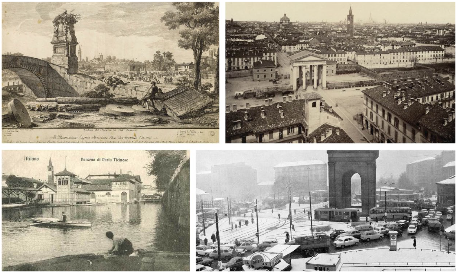
Four views of Porta Ticinese’s area: 1810, 1870, 1900, and 1964.
The map shows a Porta Ticinese free of any defensive walls. The Darsena began in those years through transformation and optimization as a dock, keeping this role until 1979. As a consequence, the space is marked with a strong logistical character, transforming the riverbanks into storage places for sand, full of barges and cranes, but also for fairs, flea markets, and circuses. The remnants of the Spanish walls are demolished, the line of trees on top also disappears, and a new plain platform is provided and used for the storage of sand forming piles (sabbioni). The building that once housed the Canottieri di Olona is also demolished, thus opening, for the first time, one of the sides of the square to direct contact with the water feature.
The arch and both custom houses still stand but without a clear use. However, as some historical photographs show, Porta Ticinese quickly becomes one of the major traffic nodes of the city of Milano, one of the places where a large influx of cars, trams, and buses conveys. Porta Ticinese becomes a dynamic square, a condition that echoes the situation of other European aforementioned places. The speed, the power of the machine, the moving masses, and the everyday congestion are the new main attributes of these modern spaces. Traffic towers (precedents of traffic lights such as the one installed in 1925 in Piazza del Duomo) are tested in some of these squares, and part of the classic paving is progressively replaced by continuous strips of asphalt. 65 These nodes are a clear register of the impulses of modernity that transformed these interstitial meeting points for activities and mixt uses, into strategic links of the system of routes and, therefore, a place where the effectiveness of movements prevailed. The basic goal—increase speed and reduce contact—is achieved in multiple ways: roundabouts, traffic lights, multiple levels, segregation of lanes, and urban cloverleaves. In Porta Ticinese, a complex system of tracks and lanes is evident, thus transforming the historic empty esplanade into a traffic intersection and segregated islands between the lines.
The map of Milano in 1946 also shows the aforementioned process of covering the canals of the inner core (Cerchia Interna), mainly motivated by health issues, traffic improvement, and new real-state opportunities. These works were finished in 1929, leaving almost exclusively the Naviglio Grande and the Naviglio Pavese as the memory of a rich canal system.
However, the data linked with the 1946 Censimento register also allow a more precise description of the activities and demographic composition of the neighborhoods around Porta Ticinese, an interesting source of information to compare with today. In the analyzed area (see Figure 5), there are around 240,000 censused residents, as well as around 875 stores (a number similar to the current stores, 911) with nearly 1000 registered workers. Likewise, its condition of storage space (circa 145 warehouses) and, to a lesser extent, of craft workshops (around 120) is also notable. It is, therefore, a place already in 1946 with a marked productive and logistical character, a fact that led, in the 1970s, to the construction of the market in a similar position to the current market. 66
Composed map of the Censimento 1946.
2012: Porta Ticinese, from Darkness to Nightlife
The evolution of Porta Ticinese’s area between 1946 and 2012 is marked by a slow and progressive consolidation of the architectural limits of the area. This is the time of the construction of the porticoed offices of Intesa San Paolo (around 1960) on the ruins of the damaged buildings of the Second World War, 67 or the construction of the Palazzo BPM around 1965, on the corner of Corso Porta Ticinese. Other buildings such as the one at Viale Gorizia by the architect Marco Zanuso (1946-1952) are also remarkable examples of the significance of this place with elaborate pieces of architecture. 68
However, as described in the previous chapter, the Darsena continues its degradation, turning it into an industrial and logistics landscape, illuminated by dim night lights but also developing its unique post-industrial aesthetics. It is not surprising, for example, that it is a selected scenario of films like Ragazze d’Oggi (Luigi Zampa, 1955) or a scenic background for fashion photographers such as Ugo Mulas (1958). This spiral of decline was consolidated in 1979 with the arrival of the last ship to the Darsena, leading to the final transformation of the place into a parking lot and abandoned area. In 1980, the Olona river is definitively disconnected from the Darsena 69 and the Navigli channels near Porta Ticinese also begin to lose their attractiveness and become a derelict place. The urban fabrics, in turn, are considered areas to be “restructured” according to the Piano di Edilizia Economica Popolare of 1968.
Despite that, it is important to note that the place continued to be in the daily experience of the people, the abandonment of the area does not make this place disappear, as it is a strategic link to access the inner city. Hence, it is no coincidence that in 2004 a competition for the renewal of this area began, along with the recovery of La Conca lock as the first step in the future recovery of the system of inner Navigli. This process has been consolidated after the powerful emergence of the movida serale, a movement of public space appropriation for nightlife activities. 70 Although this social phenomenon is present in other places of the city of Milano, especially linked with the former city gates (see Figure 6), the movida takes a special presence in the surroundings of the Porta Ticinese, a perfect scenario after the disappearance of the logistical or industrial activity at the shores or Ripas of the Navigli.
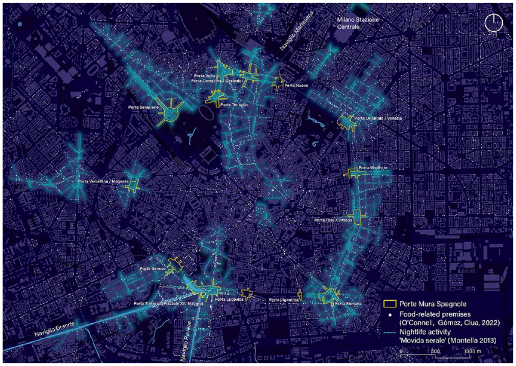
Relationship between nightlife activities (Montella 2013) and the “Porte Milanese.” White dots represent all the restaurants, bars, pubs, pizzerias, and other food-related premises in (O’Connell, Gómez-Escoda, Clua, 2022).
2022: Porta Ticinese, an Excentric Center
As described in the previous chapter, the abandoned state of the Darsena was the starting point of a design competition organized in 2004 in preparation for the Expo 2015 in Milano under the motto “Feeding the Planet, Energy for Life.” The winning proposal by J. F. Bodin, E. Guazzoni, P. Rizzatto, and S. Rossi proposed the redesign of the Darsena through the reconstruction of the riverbanks, the renaturalization of the western side of the area, the recovery of the footprints of the Spanish walls, the construction of a new market, and the redesign of the square around Porta Ticinese’s arch. This re-urbanization started the recovery of a section of the aforementioned “Ticinello” channel and gave more space to the pedestrian by using a single pavement and optimization of the tramway tracks. With this transformation, the Porta Ticinese area has undergone a substantial change as a public space, also consolidating a positive vision of water and, consequently, opening the imagination to the possible recovery of the historic canals.
But together with the gradual consolidation of the Darsena as a leisure area, nightlife activities have been consolidated and promoted. This is especially relevant in Figure 7, a cartography of current restaurants, cafés, pubs, pizza and food-related premises (red), and other ground-floor activities (blue) within an area of 1,600 × 1,200 m. As mentioned, a total number of 911 premises have been recorded. Of them, 57 percent of establishments represent food-related premises. However, considering only the four streets leading to Porta Ticinese, it is worth noting the uneven distribution of these activities. Along the Naviglio Grande channel, 102 premises are located and 81 percent are restaurants or food-related premises. Naviglio Pavese presents a similar distribution although with a smaller number of activities (67). In turn, Corso de San Gottardo only concentrates 31 percent of restaurants, and the rest of them (63) are premises not related to food consumption. In Corso Porta Ticinese, the distribution is a bit more equative, as 38 percent of 64 premises are restaurants.
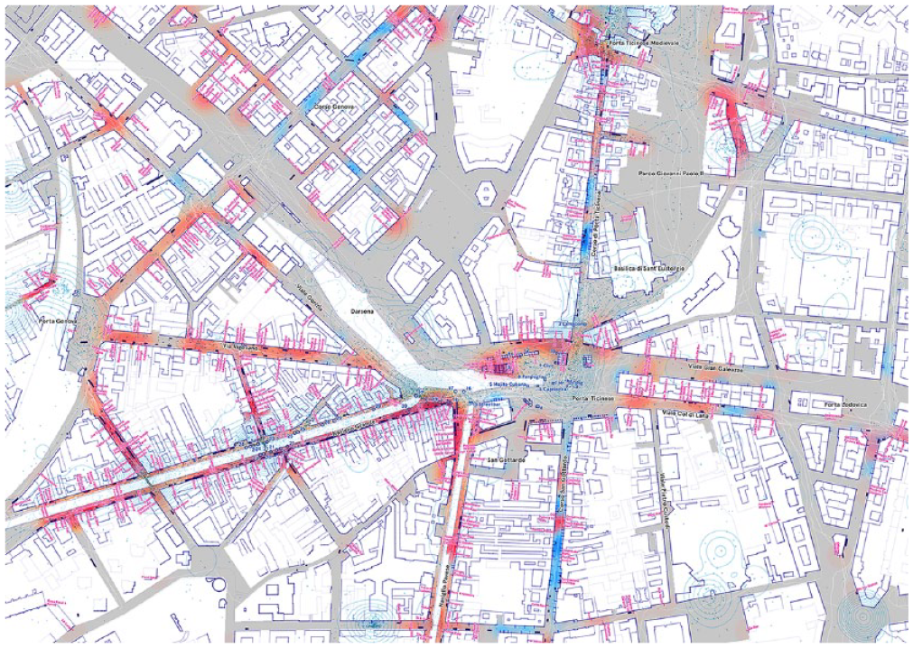
Cartography of Porta Ticinese’s area in 2022. Red color represents clusters of restaurants, bars, pubs, and food premises. Blue color represents other premises located on the ground floor. Dark blue rectangles represent terraces. Small blue dots are the geolocation of photographs retrieved from Flickr in 2019. White lines are the representation of 235 walking routes tracked by users of Wikiloc (until 2022).
This distribution of uses not only characterizes the uses of the ground floor but also influences the occupation of the sidewalks by bar terraces, both ordinary and extraordinary terraces registered by the Milano city council during the COVID-19 restrictions. 71 The distribution is also uneven, being the Naviglio Grande the most crowded space of the studied area: one terrace for every 9 m of the channel. While in streets such as Corso San Gottardo, only one terrace for every 24 m can be found.
However, this uneven allocation of activities around Porta Ticinese’s area is also relevant because it points out a powerful correlation between the real use and the urban form. On one side, the geometrical layout of the street pattern converging to Porta Ticinese’s arch marks the axis Corso Porta Ticinese and Corso San Gottardo as the main direction of potential movement, as it is a key and historical line of access to the interior of the city. This fact can explain the allocation of varied kinds of uses along the street (red and blue colors) and the absence of terraces due to the strong power of traffic and the limited space. These are mainly streets whose activities take advantage of people passing by. In other words, these ground-floor activities are mainly caused by the so-called “through-movement,” a concept and mathematical measure used in spatial analysis by the field of research “space syntax” to describe most used streets going from any point to any other point of the network using the shortest distance. 72 This condition was also relevant for the allocation of a marketplace at Porta Ticinese in the last century (see previous chapters).
On the other hand, the activities along the Navigli might be considered rather as destination points, or, according to space syntax’s terminology “to-movement.” 73 What used to be a strategic allocation for warehouses for cheese and other goods coming from the channels, now the water is working as a catalyzer of leisure activities, distancing its condition as a logistical platform and offering, instead, a fresh and comfortable environment. Restaurants, bars, and nightclubs are located here taking advantage of the proximity to highly accessible streets and its more secondary position toward the through-movement patterns. In the end, those activities are creating an attractive cluster of people out of the daily itineraries.
This shift between “through-movement” and “to-movement,” between the logic of the urban layout and the power of attraction of the activities along the Navigli, is also highlighted by two additional sources of data. The mapping of 235 Wikiloc walking routes in Milano in 2021 confirms the predominance of the diagonal itineraries from Corso Ticinese to the Navigli. This unnatural track of movement is also highlighted by the current location registered on October 2022 of ephemeral stalls—food trucks—and informal vendors (Figure 8). They are located at the southern edge of the Darsena, taking advantage of the movement of pedestrians as potential consumers.
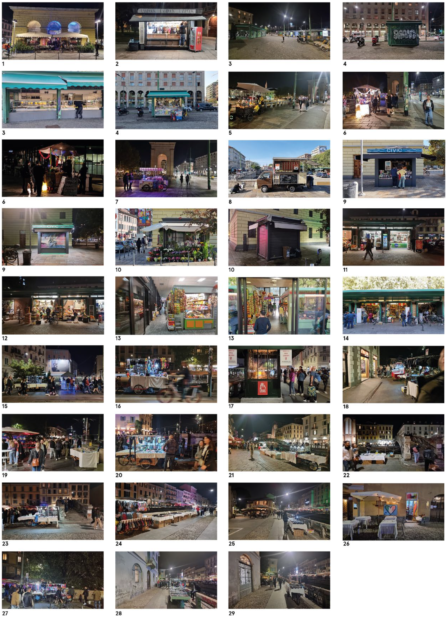
Photographs of the informal stalls and kiosks within the area of Porta Ticinese, Milano.
“What Time Is This Place?” Four Attributes of the Dynamic Condition in Porta Ticinese
Given the historical reading of the cartographies from 1804 to 2022, one of the most outstanding attributes of Porta Ticinese—Piazza XXIV Maggio—is the high level of urban changes happening within this area. Although transformation is an inherent feature of the urban condition, it should be acknowledged that urban thresholds concentrate on a high degree of change. 74 To put it in Martin Wagner’s words regarding the study of the Weltstädtplatze in Berlin, these urban spaces might be understood as “ephemeral squares,” as they are constantly changing and transformed. 75 Hence, no clear answer might be given to the question of “what time is Porta Ticinese’s area.” This question, which recalls the work by Kevin Lynch, 76 points to the fact that it is a place in constant transition, where activities and urban form evolve alongside. Porta Ticinese is an urban space whose geometric shape is not a static attribute, but a scenario that time has shaped according to the activity’s rhythm, 77 and a place that can offer a synthetic register of the evolution of the whole city: from Milano as a walled city or water city to become a key space in the nineteenth-century expansion of the city, as a traffic junction during the irruption of the motorized traffic in cities, as a logistic platform in the twentieth-century industrialization period, as a scenario for the nightlife blooming, and as the vindication of the public space for a healthier and more comfortable city.
This perpetuum mobile condition might be further illustrated in four additional synthetic maps exploring the changing geometry of the place, the role of the permanences, the evolution of the water system’s presence, the variations in the uses, and the multiple scales of the place.
A Place with a Changing Shape
The dynamic condition is primarily expressed in the geometry of the place and, therefore, in the way the space is perceived. This issue can be easily understood in Figure 6. By using isovists.org software, it is possible to compute and visualize a varied number of geometrical attributes derived from the viewsheds taken from each point of the space. 78 The software calculates geometric properties resulting from the superposition and interaction of a large number of stochastically selected fields of view from a given set of points. The result allows us to recognize graphical and numerical values describing the perceptual properties of space.
Among the multiple parameters that could be studied, the Average Radial measure has been selected for this research. This value is a normalized measure of isovists that expresses the mean view length of all space visible from a location. While higher values highlight those concave places with greater dimensions, small values usually indicate corners or unidirectional spaces of lower concave proportions. The first is especially suitable for detecting square-type spaces, while the second tends to highlight elongated geometries such as streets or alleys (Figure 9).
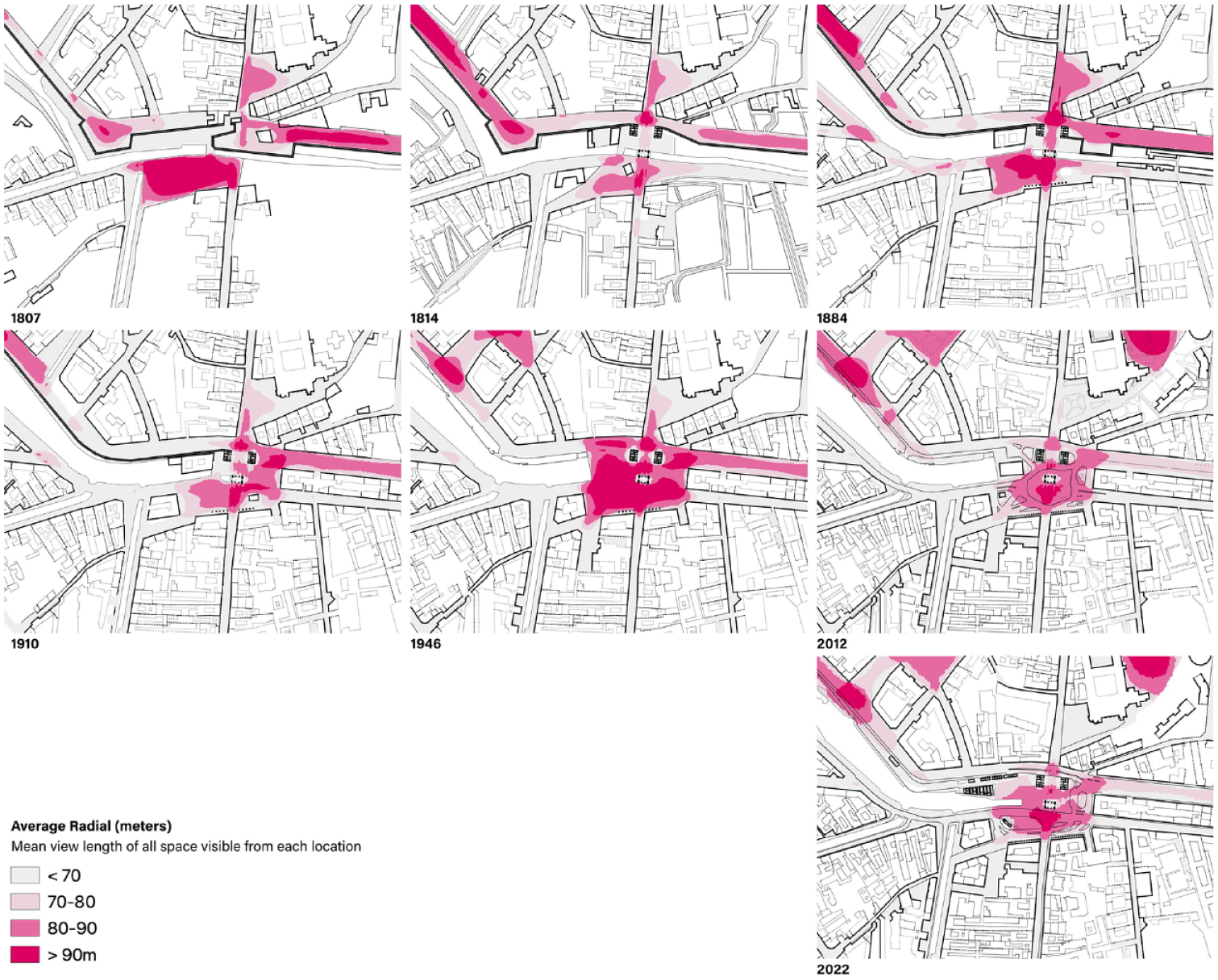
Comparison of average radial analysis of Porta Ticinese—Piazza XXIV Maggio from 1804 to 2022. Red areas describe the largest mean view length of visible space from each location or, to put it in other words, the largest square-like spaces within the area.
The distribution of the Average Radial calculations in Porta Ticinese’s area is useful to understand the changes in the perception of the space from 1807 to 2022. In the 1807 map, the widest square-like space is concentrated outside the walls, configuring an esplanade used as a marketplace. In 1814, in turn, the Porta Ticinese’s largest open space is fragmented into the smallest one, as the large esplanade is occupied by a new building and the aforementioned gabella or small edicle for collecting urban taxes. The outer space was enlarged in 1884, after the demolition of that building. However, the construction of a small kiosk at the eastern side of the space drastically reduced the size of the square-like area around Porta Ticinese’s arch. The image in 1946 shows a remarkable widening of the open space around the arch, following the coverage of the water channel. However, this perception might not be understood as a real increase in the space for pedestrians, as it will be defined as a junction point for tramways, buses, and automobiles. In 2012, the new market built on the western edge of the square finally reduced the spatial wideness of the previous stages. Here, the arch and custom houses work as the northern façade. Finally, in 2022, the recent renovation of the place has located the new market in a lateral position, thus configuring a wider perception of the place framed by a new kiosk on the southern side of the space.
In the end, the evolution of the geometry of the place might be read as a progressive regularization of the space. From the first images of the area, today the shape of the square Piazza XXIV Maggio is almost stabilized and consolidated. This progressive construction of the geometry might lead to calling this place an “inductive square,” that is, a square defined as a long result of confrontation with the context and vice versa. 79
Permanences as Centers of Gravity
Urban thresholds like Porta Ticinese’s area are configured by, at least, the tension between two determining force vectors: (1) the vector that connects both parts, the interior with the exterior, the compact medieval fabric with its suburbs, and the city realm under taxes with the space outside the walls and (2) the vector perpendicular to the first, and defined by the transverse structures that cross it: the walls, channels, free space system, or ring roads. The preponderance of each vector is mutable and gives a strategic explanation of the use of the place. In Porta Ticinese, for instance, the vector toward the city core has been present in 1807, 1814, and 1884, while the demolition of the walls and the opening of the new boulevards registered at the map of 1910 and the subsequent integration of the Darsena as a vivid public space have reinforced the transverse vector as a new direction of the place.
However, as a corollary of the previous remark, it might be stated that transition spaces such as Porta Ticinese—Piazza XXIV Maggio—do not only have a dynamic geometry or changing directions but usually there are one or multiple gravity centers that stabilize the space. These are permanent presences, organizing movements, and giving meaning to the place. The role and use of these elements can be changed but the perceptual importance tends to be invariable. In the last two centuries, Porta Ticinese’s arch has been working as a clear gravity center. As Figure 10 shows by overlapping the maps from 1807 to 2022, the arch and the two custom houses are the most prominent presences within the central space. It is not a coincidence that most of the photographs registered on social media such as Flickr are concentrated on this iconic landmark (see Figure 7). This element, together with the Quercia Rossa oak tree located at the southern part of Piazza XXIV Maggio, is still the visual center of the square.
Overlapping of seven maps of Porta Ticinese’s area: 1804, 1814, 1884, 1910, 1947, 2012, and 2022. Darker colors highlight the most permanent elements such as the arch or the two custom houses.
The Changing Water: From Hydric Infrastructure to Ecology System
Another of the most persistent elements in that place is the water. But although its existence has been a constant element throughout the last two centuries, both its geometry and its urban role have indeed been mutating: from its origin as a water infrastructure for irrigation in Lombardy and use by the city of Milan to becoming an important logistics structure for construction materials or food, and later being used as a means for washing clothes, a space for active leisure (swimming or rowing) or, currently, as a recreational and contemplation space, and as a way of providing environmental comfort to the place.
It is no coincidence, therefore, that water is precisely one of the factors with the greatest presence and that, in some way, it has catalyzed urban activities at every historical moment. 80 The reason for the activities, also today, is closely linked to water as a factor of attraction and environmental quality. In any case, it is notable to see that, once again, the water is promoting the inner renewal of the city of Milano with the recovery of the canal system as a new environmental and social infrastructure. 81
Urban Tissue and Activities
The persistence over time is not only an attribute of the centers of gravity but the alignments of facades along the Navigli or Corso di Porta Ticinese or San Gottardo streets are also evident. However, it is an apparent stativity, since the uses located within these buildings will vary throughout history: first, they were warehouses dedicated to the storage of goods (mainly cheese, the so-called casere); second, the courtyards served as a shelter for the illegal merchants or estrosadori; later, it became a place to dry clothes after cleaning them in the Navigli and a highly populated residential area. Today, these buildings are privileged spaces for the location of restaurants, bars, and pubs. Therefore, the fabric around Porta Ticinese is a fabric where the activities are also dynamic, configuring itself as a space of spatial transformation at the pace of the urban changes in the area.
Despite the different nature of the activities that inhabit the urban tissue around Porta Ticinese, it is worth noting that all these uses are linked with interchange and transaction as the core characters. The current Fiera di Sinigaglia—a weekly flea market—is a relevant example of that. And second, these are activities alluding both to a metropolitan scale and also to the local use of its inhabitants. They have the “double-locality” condition. 82 Therefore, the square might be regarded both as a “territorial square”—gate, port, nearby railway station, and tourist attraction—and as a place for daily itineraries surrounded by neighborhoods. This dual condition might be seen as the true essence of the place. All these activities—including the nightlife attraction—should not be seen as the result of hazardous urban dynamics, but as a reasonable and rich marriage between the interstitial condition of the place and the environmental conditions provided by the Navigli (see Figure 6). Porta Ticinese’s area is a place of passage, an urban inner edge with a colliding social structure. The “gate condition” originated with the construction of the last walls of Milan is still present. This statement might be regarded as one of the main explanations why the nightlife venues in Milano today are located around the ancient gates. 83
Urban Thresholds and Interstitial Urbanity: Concluding Remarks
The evolutionary study of Porta Ticinese’s area has provided evidence of how both form and activities of urban thresholds are not static assets. The form tends to become more precise and regular, while the activities—despite the specific differences at each time—tend to maintain the character linked to metropolitan and local transactions, combining formal and informal uses. This condition promotes the generation of a unique kind of urbanity, understood as an attribute defined by the quality of relationships between the urban things, the people, and the environment. 84 This is a kind of urbanity that we could describe as “interstitial,” which accounts for the very meaning of the Latin word “interstitium”: inter + statum, the space where you stand in-between. In light of the argument described in the text, the interstitial urbanity might be described by two simultaneous facts: on the one hand, urban thresholds have an evident negative meaning as they are inevitable residual spaces left by well-identified urban tissues, and, on the other hand, they are central spaces in everyday transactions and urban mobility. Both centrality and periphery might be experienced in these spaces, thus highlighting both their condition as key landmarks of the city and no man’s land condition. 85 This eventually explains the promotion of unique kinds of ephemeral or permanent activities and the aforementioned particular conflicts between locals and visitors.
The discussion on the role of the water in Porta Ticinese leads to highlighting the systemic condition of this kind of spaces, which is manifested in the interaction with the other gates or porte of Milano. However, this is not exclusive to this case study but points to one of the most representative scale factors in urban thresholds. Due to their historical connection to defensive systems such as city walls, urban thresholds still configure today an interconnected system. This can be observed both in the mental map used by citizens when navigating through the city and in the high impact that boulevards connecting these spaces have on everyday urban mobility. This systemic dimension makes urban thresholds potential or actual hubs of mobility and might inspire a future rethinking of each city from an ecosystem redesign perspective. Urban history studies, in turn, might also find in the figure left by urban thresholds—what might be called the “in-between city”—a rich field of research, since these areas might be acknowledged as living registers of the changes that each city faces.
Finally, the reconstruction and comparison of historic maps have been a clear way to identify the changes in the spatial configuration of Porta Ticinese and it might be easily replicable in other case studies. However, to evaluate the role of activities over time, data is more limited and the analysis conducted in Porta Ticinese’s area would be more difficult in other similar places without such thorough historiographical sources and census provided. The study leaves open other lines of research focusing on the evolution of socio-economic context or mobility patterns in urban thresholds. However, this has not been yet developed because obtaining high-resolution and comparative chronological data is not easy or feasible. That leads to the fact that evaluating the dynamics of urban spaces might be often strictly based on an accurate reading of the urban form as the most eloquent expression of the evolution, thus confirming the urban as the most essential—yet sometimes hidden—expression of social behavior in cities. 86
Footnotes
Acknowledgements
The author would like to thank Gilen Txintxurreta, architect, Celia Díaz, and architecture students at Barcelona School of Architecture (ETSAB) for their support in the production of some of the illustrations. The author conveys special thanks to Aleix Salazar, architect, for providing updated photographs of Porta Ticinese in Milano (October 2022). The author would also like to thank prof. Patrizia Gabellini and prof. Giulia Fini (DAStU) from the Politecnico di Milano for their king support during the initial stages of this research. The author would also like to thank the anonymous reviewers who, with their generous remarks, have substantially improved clarity in the presentation of the methodology, background, and results of the research.
Declaration of Conflicting Interests
The author(s) declared no potential conflicts of interest with respect to the research, authorship, and/or publication of this article.
Funding
The author(s) disclosed receipt of the following financial support for the research, authorship, and/or publication of this article: This study started during a research stage at the Politecnico di Milano, thanks to the financial support from the Youth Investigators Training Program 2019 (Associazione di Fondazioni e Casse di Risparmio Italiane SpA ACRI).