
Abstract
In South Korea, the nation with the world's highest density of nuclear power plants, the disposal of high-level radioactive waste has become a pressing sociotechnical concern. Faced with local residents’ refusal of disposal facilities, scientists at the national research institutes have been making their case that the nation's underground is a safe and trustworthy site for radioactive waste disposal. This paper examines three strategies used by government scientists to turn the underground into a reliable container of radioactive waste. First, their practice of mapping mitigates uncertainties about underground irregularities and produces a widely acceptable representation of strata. Second, scientists utilize simulations to contain long-term changes and extend their epistemological power into the far future. Third, scientists propagate their subterranean visions to a broader audience by using underground laboratories as a site of demonstration and persuasion. These spatial, temporal, and cultural strategies let scientists and the Korean government consolidate the strata into physically durable and politically governable territory. The analysis of geological disposal in South Korea asks us to move beyond the technopolitics of extraction to explore that burial as an increasingly important site for STS research.
Introduction
Over the past few decades, the disposal of high-level radioactive waste has become a pressing sociotechnical concern for nuclear-reliant South Korea. While the nation has the world's highest density of nuclear power plants, it has not designated any site to dispose of spent nuclear fuels. As temporary storage facilities for the spent fuels are nearing their full capacity, having no permanent disposal site became a critical threat to maintaining the nation's energy regime. While the disposal of high-level radioactive waste has been a grave challenge for most nuclear-powered nations (Hietala 2021; Macfarlane 2003; Sundqvist 2002), South Korea has experienced further difficulty due to the nation's small territory and high population density. So far, nine attempts have been made to site a disposal facility for high-level radioactive waste, yet all of them turned out to be unsuccessful as they confronted severe opposition from environmental activists and citizen scientists concerned about the possible radioactive leakage from the facility. Currently, South Korea only possesses a disposal facility for low- and intermediate-level radioactive waste in Gyeongju, which does not store high-level radioactive waste like spent nuclear fuels.
Faced with widespread opposition to geological disposal, the government has employed geological science to generate consensus on the underground facilities. Since 1997, the Korean government has started investing in national research programs to generate scientific evidence on the safety and efficiency of geological disposal (MOST 1997). Experts at government-funded research institutes became key actors in subterranean politics, tasked with providing the scientific rationales for siting and constructing underground facilities for nuclear containment. Government scientists were commissioned to survey the soundness of the nation's bedrock, simulate geological changes, and propose potential designs for underground facilities. In recent years, South Korea's investment in these geological sciences has rapidly surged as the government announced a master plan to construct and operate a disposal facility for high-level radioactive waste (MOTIE 2021).
In this paper, I argue that the Korean government's attempt to measure and model the underground space is much more than a passive tool for safety evaluation. Instead, it is a technopolitical project to transform the underground space into governable and appropriable territory (c.f. Braun 2000; Elden 2013; Scott 1998). Government institutes and their affiliated scientists employ geoscience to propose underground space as an appropriate site for radioactive waste disposal. Their scientific projects generate official representations of strata by producing consensus on diverging subterranean visions. The government's geoscience research also creates and propagates a spatial imaginary of the underground as a physically durable and economically reasonable place for nuclear containment (c.f. Hietala 2021; Kearnes and Rickards 2017). Through state-funded geoscience, I argue, the Korean government and its scientists consolidate the nation's strata into a safe and trustworthy place for radioactive containment.
In what follows, I identify three major territorializing strategies South Korean government scientists use to transform the underground into a reliable place for radioactive waste disposal. First, experts generate a consensus on underground risk by generating an official map of subterranean features. These maps mitigate diverging opinions on the geological risks, enabling public decisions on underground appropriation. Second, nuclear engineers develop simulations to contain the future risks caused by geological changes. Through their geological models, the underground becomes a scientifically safe, economically available, and politically plausible place for waste disposal. Third, scientists propagate their subterranean imaginations to a broader audience by using underground laboratories as a site of demonstration and persuasion. The laboratories are not only a test bed to evaluate the bedrock's integrity but also the place where social trust is tested and consolidated (c.f. Shapin 1984).
Expanding the Vertical Reach of State Power
In this paper, I conceptualize the siting of a radioactive waste disposal facility as a unique form of territorial challenge in which the state must expand its spatial power into the deep underground. Since the spent nuclear fuels can cause significant harm for thousands of years, governments want to dispose of them in places far from populated areas. In the past, remote places like the deep sea and Antarctica were considered ideal sites for radioactive waste disposal (Hamblin 2008). However, radioactive waste cannot be simply expelled from the state's territory because, if left untended, the leaking radioactive materials may cause significant health problems (c.f. Hecht 2012). Even worse, the spent fuels can be appropriated for making nuclear weapons. Due to these potential risks, the export of radioactive waste is strictly regulated in many nations, making it a unique territorially bound object.
The placing of radioactive waste, therefore, is a result of the tug-of-war between two opposing forces: states want to put them as far from their territory as possible, but they cannot be placed too far out of the state's oversight. The siting and construction of a radioactive waste disposal facility, therefore, involves locating the physical, political, and cultural edges of the territory and incorporating them into the state's territorial order. Under this theorization, this paper examines how siting and constructing a geological disposal facility motivates the state to expand its vertical reach of power into the deep subterranean space, both politically and scientifically. More specifically, it asks how the government's geoscientific project transforms the underground from unruly, mysterious, and disorderly space into governable, calculable, and controllable territory for appropriation (Braun 2000; Elden 2013).
Recent studies in political geography provide helpful conceptual tools to examine the role of government science in making and appropriating the subterranean territory (Bobbette and Donovan 2019; Marston and Himley 2021; Squire and Dodds 2020). Political geographer Bruce Braun analyzed how national surveys for mineral resources in the nineteenth century provided epistemic conditions for the Canadian state to capitalize on its underground territory (Braun 2000). Governmental surveys made its interior legible and consequently brought previously marginal underground space into the circuit of power, capital, and logic (c.f. Scott 1998). Conversely, the inability to read through the strata can hamper the state's political authority in governing its subterranean space (Slesinger 2020). I argue that geological disposal shares a similar sort of knowledge politics with the well-studied cases of mineral extraction. In both cases, geological knowledge is strategically employed by government actors to expand the state's vertical reach of political power. If the mineral surveys work to transform the subterranean into a resourceful space waiting for economic appropriation, the scientific projects for geological disposal render it into a durable space capable of nuclear containment.
Previous STS literature has well documented the entanglement of technoscientific knowledge and underground governance in radioactive waste disposal (Geysmans et al., 2023; Lagerlöf et al., 2022; Sundqvist 2002). Macfarlane (2003), for instance, analyzed how the Yucca Mountain project required US geologists to generate highly detailed knowledge on underground features such as groundwater connectivity, geochemical reactivity, and subterranean mobility of radionuclides. This geological knowledge significantly shaped the governance of underground territories as regulators altered the criteria for site selection when new information emerged. Through this mutual construction of geological research and regulatory process, the geophysical capacity and geopolitical plausibility of Yucca Mountain were constantly reimagined. Building upon this framework of co-production, this paper asks what the underground space becomes through (and only through) the research of government scientists. It focuses on how geological disposal necessitates states to become generators of vast spatial knowledge of their underground territories and how this knowledge, in turn, affects the way in which states exert power over the deep underground.
The state's attempt to make its underground territory legible is challenging because of large scientific uncertainties from exceptionally long-term risks posed by radioactive waste (Poirot-Delpech and Raineau 2016; Schröder et al., 2016; Uggla 2004). Furthermore, actors with competing environmental interests develop contrasting geological knowledge with diverging implications, making underground politics far more complex (c.f. Kroepsch 2018). Given the large uncertainties and multiplicity of interpretations, building scientific consensus on the nature of the underground emerges as an important challenge of underground governance. Previous studies have emphasized policy measures such as conceptual flexibility as strategies for establishing consensus (Elam and Sundqvist 2011; Lagerlöf et al., 2022). Others highlighted how the introduction of participatory procedures affects the social acceptance of technological solutions (Bergmans et al. 2015; Brunnengräber and Di Nucci 2019). This paper, on the other hand, pays more attention to the strategies embedded within the government's scientific research itself (c.f. Uggla 2004). Specifically, I observe what kinds of practices are employed to mitigate the intrinsic uncertainties of subterranean features when government scientists produce official maps and models on underground territories. I conceptualize this scientific work as a less analyzed yet crucial territorializing strategy that allows states to know and govern their subterranean domain.
This paper also pays attention to how government science produces popular imaginaries and narratives on the underground (Geysmans et al., 2023; Hietala 2021; Kearnes and Rickards 2017). Geological disposal is not only a technological task but also a challenging cultural project where governments promote spatial imagination of the underground as a manageable and durable site of containment. Hietala (2021), for instance, explored discursive strategies used by Finnish scientists to frame the underground as an inert and timeless space far safer than the unstable above ground. Geysmans et al. (2023) focused on the role of an underground laboratory specialized in geological disposal research and argued that the facility is more than a site for experimentation. It has functioned as a privileged place where authoritative narratives about underground futures are produced. These studies suggest that we must regard geoscience for geological disposal as a cultural strategy of territorialization, and examine how it may influence a broader audience beyond the expert community. In this regard, this paper also examines how South Korean experts generate and disseminate new spatial discourse about the nation's underground space through their technoscientific practices.
Method
In order to analyze the territorial strategies of government-funded geoscience, I conducted a literature review of technical reports and papers published by two major Korean research institutes. The institutes of interest are the Korea Institute of Geoscience and Mineral Resources (KIGAM) and the Korea Atomic Energy Research Institute (KAERI), which are the two most significant knowledge providers for South Korean radioactive waste policy. KIGAM is the nation's primary geoscience institute and conducts nationwide underground surveys to produce basic data required for siting a disposal facility. KAERI is the leading organization in nuclear engineering that has been operating an underground laboratory since 2006 to develop geological simulations for safety evaluation. This paper zooms into their research to understand the role of their scientific practices in transforming the underground into appropriable territory.
The primary data for this study comes from the reports produced by the two institutes from 2010 to 2022. The majority of these documents are final reports of government-funded research projects. The reports were gathered through the official libraries of the two institutes. Some of the reports that are not available from these libraries were accessed through the International Nuclear Information System (INIS), an international repository of nuclear-related documents maintained by the International Atomic Energy Agency (IAEA). In addition to the official reports, I gathered and analyzed journal articles authored by experts in these two institutes. Papers in Korean and English were collected from journals in the field of nuclear engineering and geology.
Both reports and journal articles contain detailed methodological descriptions of how government scientists gathered, processed, and presented data for their research. These descriptions provide valuable resources to examine how sociopolitical considerations on geological disposal heavily affect the design and interpretation of government-funded geological studies. As I critically read through these documents, I analyzed the technique, rhetoric, and logic that government scientists developed to tame diverse uncertainties in knowing and governing subterranean spaces. I also paid attention to maps, diagrams, and models that appear in the reports and asked how these spatial representations embody both scientific and political expectations on underground territories. Together, the document analysis aimed to show that geological research functions as an important governmental strategy that makes the nation's strata a reliable container of radioactive waste.
Geoscience and Geo-Governance in South Korean Radioactive Waste Politics
In this section, I provide a brief historical account of how geological knowledge emerged as an important battleground in South Korean radioactive waste politics. In previous attempts to site a geological disposal facility, the government's ignorance of geological risk was one of the critical reasons for the policy failure. The series of unsuccessful attempts led the Korean government to invest in geological research and produce scientific evidence on the safety of underground containment.
During the early phase of siting the radioactive waste disposal facility, the selection procedure was primarily driven by technocrats and a small number of experts in a top-down manner (Hong 2016). With a primary emphasis on the fast and efficient construction of the disposal facility, geological stability and public acceptance were considered only secondary to timely and economical construction. In 1991, for instance, the government commissioned the Korea Resource Institute to sort out candidate sites for a future disposal facility (KRI 1991). After examining coastal regions and abandoned mines, the institute reported that the nation's remote islands could not serve as a site for a disposal facility, given their poor geological and logistical conditions. Yet this survey result was largely neglected by the government, which wanted to construct the underground facility as quickly as possible. In 1994, the government designated Guleop-do, an underpopulated island off the west coast of the peninsula, as the candidate site for the disposal facility.
The Minister of Science and Technology argued that Guleop-do was the optimal site for radioactive waste disposal because the island has favorable geological conditions as it is composed of solid and uniform tuff (Hankyoreh 1994). The argument was endorsed by two geological experts from the IAEA, who claimed that Guleop-do is a preferable choice for the disposal facility after only a brief field visit to the island (Donga Ilbo 1995). The government's clumsy argument faced enormous backlash when KRI's detailed field survey detected an active fault below Guleop-do. Because the active fault implies a possibility of future earthquakes, the government had no choice but to immediately withdraw the designation of the island as the candidate site. The government was heavily criticized as it “failed to show scientific and rational attitude” throughout the site selection process (Hankyoreh 1995).
Similar disputes about subterranean knowledge were repeated in the government's other attempts to select the disposal site. In 2003, for instance, the government designated Wi-do, another island on the west coast, as the candidate for the underground disposal facility. The decision was based on the government's preliminary geological survey conducted by a commissioned engineering company that found the island to have favorable geological conditions. However, the scientific authority of this research was quickly challenged as a group of environmental activists formed a civic investigation team to review the preliminary survey. The team found out during their own field visit that the size of faults in Wi-do is much larger than was reported in the government's survey (Civic Investigation Team 2003). Furthermore, the group criticized the company's borehole, which they said was not deep enough to collect the groundwater and evaluate its geochemical condition. In sum, the citizen scientists concluded that the government's geological data was not exhaustive enough to determine whether Wi-do was an adequate site for the underground nuclear disposal facility (Civic Investigation Team 2003). The lack of scientific authority allowed the critics to question the government's ability to govern its subterranean territory (c.f. Slesinger 2020).
The series of policy failures forced the government to acknowledge the importance of robust geoscience as a prerequisite for social acceptance. In 1997, the Ministry of Science and Technology announced its new master plan for nuclear energy research. Where the previous plans primarily focused on developing advanced nuclear reactors, the new plan included budgets to develop technologies for radioactive waste disposal (MOST 1997). Throughout the 2000s and 2010s, the research program for geological disposal expanded while the site selection process remained in stalemate. In 2006, for instance, KAERI constructed an underground research tunnel to conduct long-term field experiments on radioactive waste (Kim et al. 2017). With the recent rise of public attention toward radioactive waste, scientific research on geological disposal has gained more momentum in recent years. In 2020, the South Korean government established the Institute for Korea Spent Nuclear Fuel (iKSNF), an organization dedicated to long-term research on geological disposal. With a budget of more than KRW420 billion (about USD300 million), the institute aims to develop essential technologies required for the construction of a geological disposal facility by 2029.
Geological Science as Strategy for Territorialization
How does government-funded research contribute to making and governing underground territory? In this section, I analyze recent geological studies conducted by the Korean government to examine how geoscience is employed as a core strategy of subterranean governance. The analysis mainly focuses on research led by two government-funded institutes: the Korea Institute of Geoscience and Mineral Resources (KIGAM) and the Korea Atomic Energy Research Institute (KAERI). By critically reading their scientific reports, I identify and analyze three major strategies developed by the two institutes to claim the nation's underground as an adequate site for radioactive waste disposal.
Mapping and Consolidating the Underground
The first strategy of underground territorialization is mapping. A geological map of subsurface features serves as the most basic data in siting a radioactive waste disposal facility. Unstable geological conditions like active faults, fractured bedrock, and fast groundwater flow can deteriorate the structural integrity of the disposal facility. Scientists aim to minimize these risks by surveying the nation's underground features and ruling out regions with poor bedrock conditions. Mapping through the invisible strata, however, is not a straightforward task due to ambiguities inherent in the interpretations of geological structures. Since experts may have different ways of assessing the size and dangerousness of an underground feature, there is no one objective way to describe a geological structure (c.f. Sundqvist 2002).
In order to make a public decision about the site for geological disposal, the government must first produce a single, socially acceptable representation of the nation's strata. A challenge for governmental scientists at KIGAM is to develop the nation's official geological map that bridges numerous interpretive gaps that exist between experts. Here, the goal of governmental science is not to generate the most exact truth but to develop strategies for moderating differences, so that the resulting map can gain political authority to become a rational basis for public decisions. The appropriability of the underground territory depends upon whether government scientists can produce such a coherent representation of the nation's bedrock.
KIGAM's (2019) recent effort to develop a national map of lineaments exemplifies mapping as a consensus-building process. Lineaments are linear fractures visible on the earth's surface that result from underground irregularities and faults. While not all lineaments are considered dangerous, geologists generally try to avoid prominent lineaments as they are indicative of active faults and future earthquakes. Lineament maps are drawn as experts visually examine landscape images to locate the width and length of fractures. Because this process relies on individual evaluators’ standards, multiple versions of lineament maps can be produced from the same dataset. In one study, KIGAM commissioned three external experts (a structural geologist, a paleoseismologist, and a geomorphologist) to develop up-to-date lineament maps based on the same dataset. The results of the three evaluators varied significantly. While the structural geologist reported there are 182 large linear structures in South Korea, the geomorphologist identified only 28 large structures from the dataset (see Figure 1). KIGAM analyzed that “differences in evaluation were caused due to the subjective analysis of evaluators” (Ko et al., 2018, 175). For instance, what an evaluator identified as four consecutive short lineaments may be regarded as one larger linear structure by another. Given such differences, KIGAM concluded that “in-depth consideration is required” to mitigate these diverging opinions (Ko et al., 2018, 175).
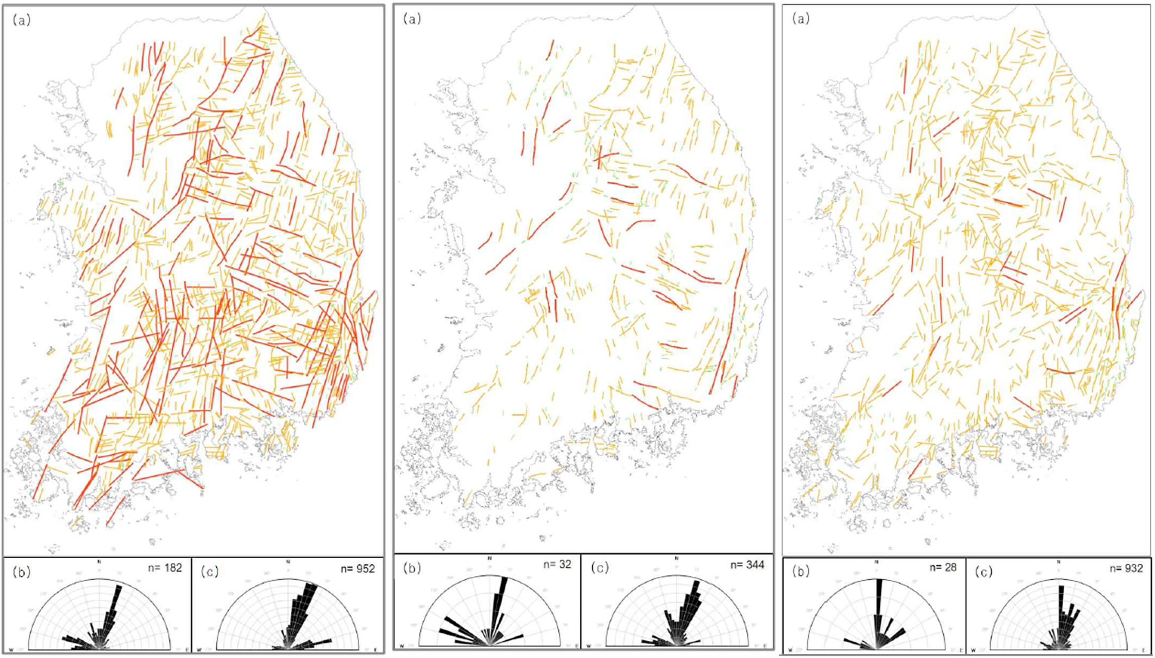
Lineament maps of the Korean Peninsula produced by three experts from common primary data. Source: KIGAM (2019) and Ko et al. (2018).
In order to use the lineament distribution as a criterion for site selection, KIGAM needed to consolidate multiple versions into one authoritative representation of the national territory. Here, the political context of siting a high-level radioactive waste disposal facility provides a guiding principle. Because the main objective of the lineament map is to rule out regions with unsound bedrock rather than to precisely identify the existence of a fault, KIGAM took the most conservative approach in combining three maps, so a lineament was added to the final map if any one of the evaluators had identified it (KIGAM 2019). By adopting the principle of conservatism, which is a widely used policy for containing radioactive risks, the researchers aimed to prevent possible disputes about the existence of underground irregularities.
A different mode of closure is found in KIGAM's related project to develop a seismotectonic map. A seismotectonic map displays geographical zones with a similar degree of earthquake risk. Each zone is given an estimated value for the maximum magnitude of future earthquakes based on past earthquake incidents. The estimated maximum magnitude is a vital factor that can decide the favorable location of the facility and the degree of seismic design needed for the underground structure. Like lineament maps, seismotectonic maps are developed by experts individually evaluating the earthquake records. In a study, KIGAM asked six geological scientists to draw their own version of maps (KIGAM 2019), based on a common list of historic earthquake data.
KIGAM reported that the expert panel “exhibited various forms of seismotectonic maps as each expert adopted different standards” (KIGAM 2019, 166). While some experts argued the peninsula has to be divided into six zones, others suggested that five zones are enough to categorize the territory. Geological experts also had different policies when evaluating the credibility of the earthquake records. For instance, when analyzing data on historical earthquakes, expert #5 only used the record of the Joseon dynasty (1392-1910) because the evaluator believed earlier earthquake records were not trustworthy enough. As a result, the six experts generated seismotectonic maps that look widely different in shape (Figure 2).
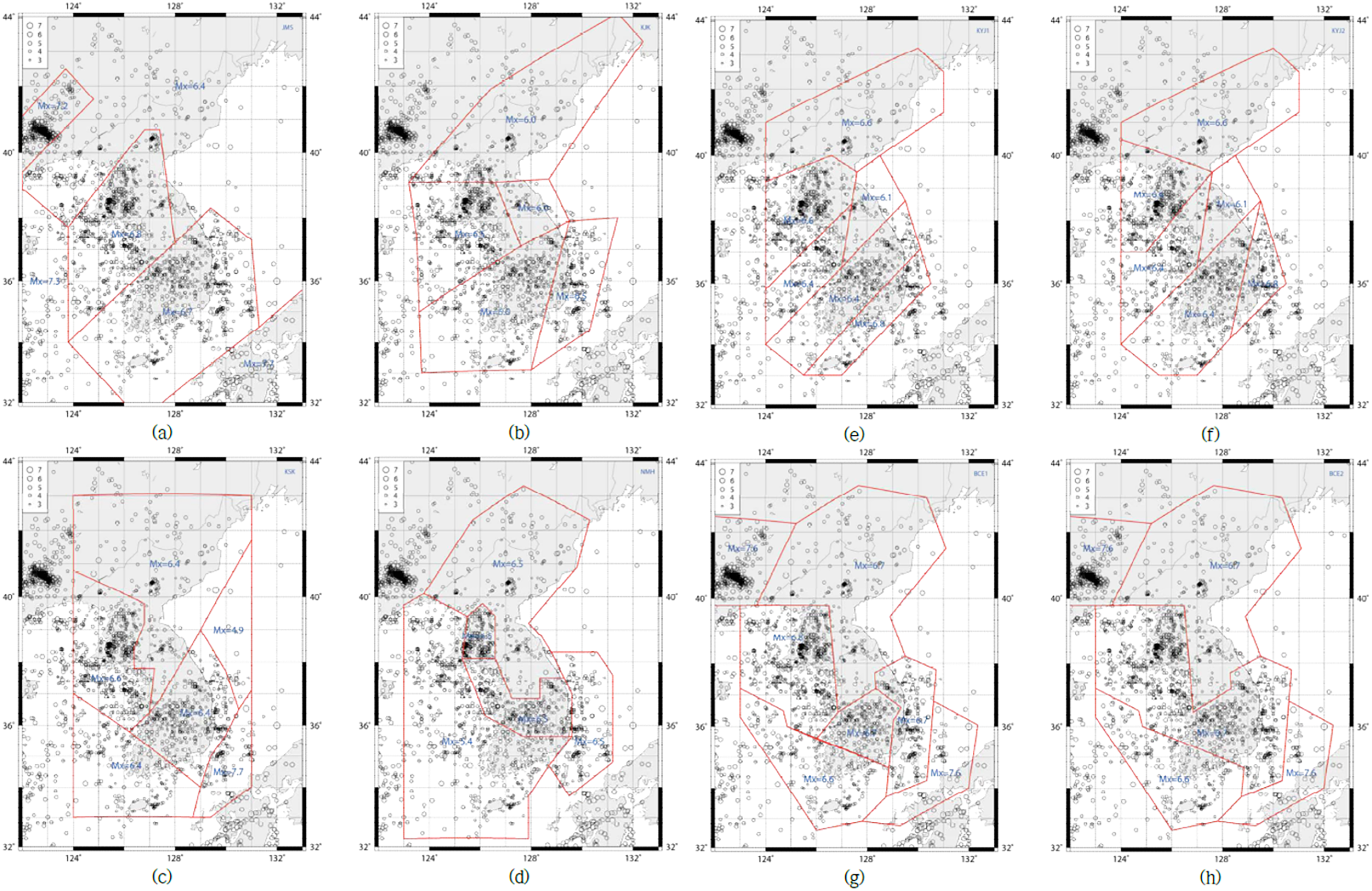
Eight different seismotectonic maps of the Korean Peninsula developed by six earthquake experts. Source: KIGAM (2019).
Given the diversity of interpretation and data usage, is it possible to make a single seismotectonic map? While there is no definite method for combining multiple versions of hazard maps, KIGAM relied on a statistical technique. Each point of the map was given a new maximum magnitude value by averaging the submissions of six experts (Figure 3). In calculating the average value, each expert was given equal weight (KIGAM 2019, 180). The method has clear advantages and weaknesses. By giving equal weight to every expert, KIGAM can avoid being partial to particular evaluators and criteria. However, taking a simple arithmetic mean circumvents more complex discussions on the validity of scientific opinions upon which each map stands. The mathematical mode of negotiation functions as a strategy to contain the scientific debate on the nature of earthquakes, the credibility of data, and the required degree of seismic design.
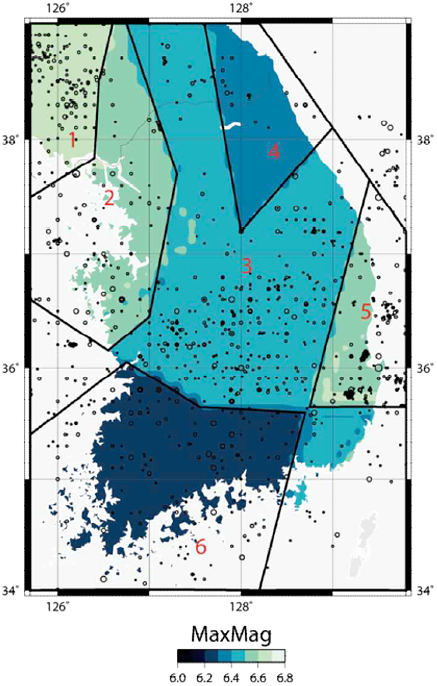
The final seismotectonic map produced by statistically combining the eight submissions. Source: KIGAM (2019).
As South Korea currently does not have an official process to decide where to construct a geological disposal facility, KIGAM's maps are primarily discussed among professional geoscientists. However, it is highly likely that they will be examined by a broader range of actors when the site selection process begins. In preparation for such future usage, KIGAM strives to make its maps more easily accessible and verifiable by publishing them online through a platform named Geoenvironmental Information Verification System (GIVES). An interesting feature of this database is that it not only displays KIGAM's geological maps but also explains how scientists gathered and processed data to generate each official map. By revealing the result as well as the process of mapmaking, KIGAM experts add further credibility to their geological maps. A transparent web platform is a means for government scientists to transform professional maps into more widely acceptable representations of the nation's underground territory.
This analysis of the two geological studies shows maps are not an exact copy of territory but, more often, a negotiation between multiple representations of space. When geologists at KIGAM produce the national map for underground lineament, they are not trying to find the objective “ground truth” about bedrock. Instead, their mapping project attempts to produce a widely agreeable version of underground representation, as experts are constantly challenged by the lack of data, the credibility of records, and their own inherently subjective analysis. The negotiation is achieved through various strategies, either by taking the most conservative guess (lineament map) or mathematically synthesizing diverging opinions (seismotectonic map). The bedrock is made solid only through such strategies of consensus-making.
Simulating and Encasing Territorial Future
The second strategy of underground territorialization is simulations that contain future uncertainties of geological disposal. Underground radioactive waste is subject to complex and interconnected long-term changes. The heat from the fuel rod causes a series of geochemical reactions that deteriorate the engineered barriers. Radioactive waste then leaks from the disposal facility and reaches above ground as it flows through water-conducting faults. Radioactive groundwater can cause harm to future populations when introduced to the food chain through irrigation or biological accumulation. Throughout this process, unexpected geological events like earthquakes or artificial drilling can accelerate the leakage of radioactive material. Here, scientific models of underground facilities function as an essential strategy for taming future uncertainties. By translating the underground events into quantitatively calculable terms, simulations make territorial changes predictable and containable (c.f. Ialenti 2020).
In order to make these future incidents calculable, KAERI scientists first developed an extensive list of possible geological incidents, which is called the feature, event, and process list (FEP list). By assigning probabilities to each incident, and then interconnecting them in a particular order, they create several scenarios with which they evaluate the safety of geological disposal (c.f. Uggla 2004). Currently, KAERI considers more than 300 events to construct five major scenarios for safety assessment (Kang et al., 2012). The “normal scenario” assumes that canisters and host rock retain their integrity as expected and do not suffer from any significant geological changes. Four “alternative scenarios” are developed to simulate the degree of harm when the facility loses its full capacity to contain radioactive waste. Each considers a critical disruption like an earthquake, well drilling, failure of canisters, and climate change. The researchers also generate and test numerous “complex scenarios” by combining these five major scenarios in various orders (Kim et al. 2018).
There is no absolute standard when compiling the event list and building scenarios. Even within a group of professional scientists, each expert may have a different understanding of underground processes. In one study, simulation developers at KAERI asked two external reviewers to evaluate their scenarios by ranking the significance of the correlation between geological events. They were surprised to find a “large deviation” among responses (KAERI 2012a, 82). The KAERI experts noted that such discrepancy occurred because experts showed differences in their “subjective understanding” of the correlations between geological events (KAERI 2012a, 82). The report recommended that “additional expert review is necessary” to find appropriate values that represent the significance of correlations (KAERI 2012a, 83). Diverging evaluations of the relation between underground events suggest that building scenarios for geological modeling necessarily involves a process of consensus-making. Producing successful simulations requires not only sound mathematical calculations, but also concrete social procedures for gathering, assessing, and mitigating different expectations on geological futures.
The construction of a simulation model also requires a vast collection of real-world data. For instance, the model requires the average rate of heat transfer in order to estimate the temperature of bedrock over time. The accuracy and representativeness of the input variables are critical to the model's reliability. In South Korea, such data is mostly produced from KAERI's underground research tunnel (KURT) in the city of Daejeon. In this mock geological disposal facility, scientists install various sensors to generate coefficients required for models to work (Park et al. 2012). Without these underground laboratories, computer simulations are disconnected from physical reality. However, precisely because input data are anchored to a specific physical place, there exists a fundamental problem of representativeness. Coefficients developed at KURT necessarily incorporate the spatial particularity of the region where the tunnel is located. For instance, since the research tunnel is built inside the granite bedrock (Kim et al. 2011), it only generates coefficients related to granite and does not produce data on other types of rock, like sedimentary rocks or metamorphic rocks. Therefore, most of the simulation studies conducted by South Korean experts often hypothesize that the future geological disposal facility will be constructed in the granite condition. Simulation models and underground laboratories shape the scientific imagination about where the disposal facility can be located (c.f. Geysmans et al., 2023).
Simulations also play an important role in governing the tradeoff between cost and safety of geological disposal. A typical example is how simulations affect the spacing of fuel rods. If the spent fuels are placed close together, the total volume of the underground structure can be shrunk, and the construction cost of the disposal facility is significantly reduced. Yet a smaller disposal facility comes with other costs. The closer radioactive rods are packed, the hotter the surrounding bedrock becomes (Kim et al., 2021). Higher temperatures may cause more vigorous geochemical reactions, potentially accelerating the facility's deterioration. South Korean experts use simulations to argue that the underground structure can withstand higher heat stress and, therefore, it is possible to construct a more compact disposal facility. While the current international convention for the upper limit of rock temperature is 100 °C, models are used to argue that the facility can successfully contain radioactive material even at 125 °C (Cho and Kim 2016). Here, simulations allow nuclear engineers to make geological disposal a more economical option for radioactive waste containment.
Simulations also embody and sustain specific political ambitions about nuclear futures. While original models by KAERI simulate the direct disposal of spent nuclear fuels, more recent versions hypothesize that the amount of radioactive waste will be drastically reduced through a method called pyroprocessing (Kim et al. 2012). Pyroprocessing is a technique of chemically reprocessing the spent nuclear fuel that can decrease the amount of radioactive waste to one-twentieth. However, the scientific plausibility of pyroprocessing is highly debated as the technology is still in the developmental stage. More importantly, the reprocessing of nuclear fuel in South Korea is currently restricted by international treaties because pyroprocessed fuel rods can be a source of plutonium, which can be transformed into nuclear weapons. Although many are pessimistic about the scientific and diplomatic plausibility of pyroprocessing, nuclear engineers consider it a possibility in their simulations. While there exist various challenges in the actual pyroprocessing of spent fuels, the geological models become an alternative site where engineers can freely express their expectations. Here, simulations serve as a means for nuclear experts to sustain their underground visions and to explore technopolitical hypotheses without restrictions.
This examination of underground simulation suggests that geological models are not fictional experiments without real consequences. They do have a concrete impact on radioactive waste management and territorial governance by shaping scientific beliefs, supporting economic arguments, and sustaining politically disputed visions (c.f. Kroepsch 2018). To build a geological simulation is to imagine an ideal disposal facility that embodies a particular set of assumptions about nuclear futures shared among technology experts. The numerical models allow government scientists to tame long-term uncertainties and naturalize the underground as a scientifically safe, economically available, and politically plausible place for waste containment.
Persuasion Through Demonstrating Containment
The third and final tactic for subterranean territorialization is propagating the underground imaginary of a safe geological disposal facility. Siting a radioactive waste disposal facility is challenged by intense opposition from local residents and environmental activists. Therefore, it is not enough to develop consensus among experts; knowledge about geological safety has to be widely accepted by a broader audience. In an attempt to make their geological vision public, scientists operate science communication programs on their research by using their underground laboratories as a site of demonstration and persuasion. The underground laboratories are not only a test bed to evaluate the bedrock's integrity but also a place where social trust is tested and consolidated.
KAERI's communication effort centers on its public tour program of KURT, the aforementioned underground research tunnel. Acknowledging the facility's role as a site of public education and promotion, the science team at the institute aspires to bring as many visitors as they can, unless construction work or highly sensitive experiments are being conducted inside the tunnel. While most of the other facilities in KAERI are off-limits, the underground facility has hosted numerous visitors. Since its construction in 2006, more than 12,000 guests have visited KURT, including students, local residents, policymakers, and journalists (KAERI 2015). The openness of the research tunnel is contrasted with the usual secrecy of nuclear laboratories (c.f. Gusterson 1996).
In a typical tour, visitors are invited first to sit at the information center in front of the facility's entrance. A researcher provides a short presentation on the current status of nuclear power generation in South Korea and the urgency of constructing a geological disposal facility. After putting on safety helmets, visitors enter the facility and walk down the sloped shaft to the bottom of the tunnel. At the end of the tunnel, there are several research modules where researchers installed various sensors that record physical changes in the bedrock. A large panel stands in front of each module to explain the purpose and history of the experiments. Visitors are invited to gather in front of each module, hear about the research objectives, and ask questions.
The tour program at KURT is a rare chance for experts to promote their geological visions to lay citizens. Observing the scaled model of radioactive waste canisters, visitors learn about the basic principles of the engineered barrier. They learn how engineers meticulously measure the heat, strength, and hydraulic conductivity of bedrock to estimate changes in geological conditions. Yet, what precedes the process of learning is the sheer bodily experience of going underground. A tour to KURT provides a temporary experience of being physically disconnected from the above ground. Only a few meters into the tunnel, the temperature quickly drops. Cell phones lose signal when surrounded by thick granite bedrock. This feeling of otherworldliness reminds them of the appropriateness of underground space in isolating the toxic waste away from human society (c.f. Williams 2008).
For citizens concerned about the safety of nuclear facilities in their town, a visit to KURT is a chance to change their perception of nuclear risk. During the site selection process for the low- and intermediate-level radioactive waste disposal facility, for instance, local representatives from the two candidate sites, Gyeongju and Gunsan, visited KAERI to participate in a tour of KURT. A KAERI researcher at the time, Dr. Kyungsu Kim, recalled that after the tour, “the public opinion quickly changed as the local residents thought that the disposal facility would be safe if it is constructed similar to KURT” (Electric Times 2022a). Nuclear engineers believe that visitors’ positive experience at KURT is one of the important factors why the government could successfully build the low- and intermediate-level radioactive waste disposal facility at Gyeongju (Electric Times 2022b). KURT also served as a site of science communication in other kinds of nuclear politics. In April 2012, 38 elderly residents from the city of Samcheok visited KURT. The visit helped them deliberate whether they should allow the construction of new nuclear power plants within their city (KAERI 2012b). In March 2015, 20 citizen representatives from Ulju province visited KURT as part of a project to gather public opinion on the management of spent nuclear fuels (KAERI 2015). In these cases, KURT provided a stage for scientific experts and citizens to exchange their visions on nuclear safety.
The communication effort taking place at KURT asks us to rethink the purpose of building underground research laboratories. As mentioned previously, geological knowledge generated from KURT has various limits due to its physical specificity. Still, KURT remains a crucial site for underground governance as a place for scientific demonstrations. As KAERI noted, KURT is not simply a research facility but plays “a role in improving the national understanding of the safety of high-level radioactive waste disposal” (KAERI 2015, 126). The underground laboratory functions as a strategic site of persuasion where scientists promote their subterranean visions on nuclear containment.
Conclusion
No bedrock is naturally solid enough to host a geological disposal facility. It is made durable only through a series of technopolitical strategies that consolidate it into a scientifically reliable container. By examining the practices of South Korean scientists at government-funded institutes, I identified three major tactics that enable the technopolitical governance of the underground. First, their spatial strategy of mapping the underground territory produces a socially acceptable representation of invisible strata. Second, their temporal strategy of simulating the underground tames future uncertainties from long-term geological changes. Third, their cultural strategy of demonstrating containment utilizes the underground laboratory as a site of persuasion. Together, these strategies allow the state to expand its power into the deep underground and utilize its subterranean environment (Braun 2000).
The government research for geological disposal is itself a social process that mitigates various disagreements about underground risks. When generating official maps and models of underground territories, government scientists devise methods to close diverging opinions on ambiguous geological features. Geological scenarios embody scientific, economic, and political assumptions about territorial futures and thereby contain uncertainties from geological changes. The state's underground imaginaries are made public through science communication activities. While previous studies on geological disposal have primarily focused on how disagreements and uncertainties are moderated through decision-making processes and policy choices (Brunnengräber and Di Nucci 2019; Elam and Sundqvist 2011; Lagerlöf et al., 2022), this paper highlights government science as a less analyzed mechanism of territorial politics.
Considering geoscience as a strategy to generate sociotechnical consensus, we should question whether these forms of subterranean governance are well aligned with our democratic principles of territorial control. Examining the technological governance of subterranean territory is particularly important given the opaque materiality of the underground. Compared with the environmental politics of air and water, where civic engagement has successfully generated alternative knowledge (c.f. Ottinger 2010), knowledge about the underground is much more difficult and expensive to produce. Alternative inquiries are hindered not only by a lack of expertise and authority, but also by the sheer material barrier that makes the underground inaccessible. Given this severe imbalance between knowledge producers and citizens, governance of the underground calls for additional effort to guarantee transparency of the knowledge-making process.
The case study on radioactive waste disposal in South Korea asks us to further explore the technopolitics of burial as an increasingly important topic for STS research (c.f. Kearnes and Rickards 2017). In many cases, burial is regarded as a technological panacea to deal with complex political conflicts caused by unwanted waste. Proposals for underground containment often emphasize the potential of emerging geological technologies while paying less attention to the scientific and political negotiations required for such uses of subterranean spaces. STS scholars must critically examine how the underground is becoming a preferred site to contain the problematic byproducts of our technological systems. We must pay further attention to designing institutional processes that can facilitate the safe and effective use of our underground territories.
Footnotes
Acknowledgments
The author thanks the members of KAIST STP for their valuable comments on the earlier version of this paper.
Declaration of Conflicting Interests
The author declared no potential conflicts of interest with respect to the research, authorship, and/or publication of this article.
Funding
The author disclosed receipt of the following financial support for the research, authorship, and/or publication of this article: This work was supported by the National Research Foundation of Korea (NRF) grant funded by the Korean government (MSIT) (NRF-2018R1A5A7025409).