
Abstract
This paper deploys the concept of unruliness to examine ethnographically how groundwater in karst landscapes resists being rendered knowable and governable. Focusing on the karst spring Klokot and its transboundary groundwater catchment (TGC) between Croatia and Bosnia and Herzegovina, I trace how practitioners and scientists grapple with the epistemic and material indeterminacy of karst. While these actors often frame such conditions as technical challenges to be solved by infrastructural or modeling interventions, I argue that such indeterminacy is not simply a property of karst but is coproduced through the entanglement of hydrogeological processes, technolegal infrastructures, and situated practices of research and governance. Klokot's TGC becomes unruly through the interplay of human and nonhuman actors across subterranean and political terrains. Attending to this unruliness foregrounds how groundwater governance is shaped by material complexity, epistemic uncertainties, infrastructural limits, and political frictions. Conceptually, the paper advances unruliness as a productive STS lens for studying surface–subsurface relationships, highlighting how material resistance and indeterminacy can reconfigure the terms of environmental knowledge and decision-making in transboundary contexts.
Introduction
“You should never forget that you are in karst here, and in karst, there are no rules,” 1 said the civil servant solemnly, sitting opposite me at a desk covered in maps, reports, and loose papers in the main office building of the national water authority of Croatia (September 26, 2022). Such reminders by practitioners of the water sector were common during my ethnographic study of groundwater management in the karst landscapes of Croatia and Bosnia and Herzegovina, where practitioners repeatedly and resolutely stressed: “But karst is difficult to model!” or “But you know, we are in karst here!” Considering this resistance to certainty, this article specifically addresses the practices of sense-making and scientific knowledge in the management of karst through a karst spring named Klokot in Bosnia and Herzegovina. Here, during one exploratory trip, an interlocutor from the Croatian mountain rescue service reflected, “So what can I tell you about the groundwater? It is in-between; it is unruly just like us” (Fieldnote, August 3, 2022). Across participant observation at water utility companies, expert interviews, and informal conversations, a range of interlocutors from water utility companies, water authorities, research centers, and consultancies all seemed to agree: groundwater in karst landscapes is particularly unruly. These attributions of unruliness inspired my central questions in this article: Why is unruliness as an attribute so predominant in scientists and practitioners’ descriptions of groundwater behavior in karst landscapes? Moreover, how might unruliness become a generative lens for understanding environments?
Klokot's transboundary groundwater catchment (TGC) lies within the transboundary aquifer Una in the Dinaric Alps, at the northeastern border of Bosnia and Herzegovina to Croatia. Such a transboundary setting poses complex management challenges as political, administrative, and hydro(geo)logical borders intersect. Due to this, Klokot's TGC is hydrogeologically characterized by unpredictable flows and high vulnerability to pollution, while politically shaped by mismatched legal regimes of drinking water protection, fragmented monitoring systems, and asymmetric responsibilities between postwar, postsocialist Croatia and Bosnia and Herzegovina. Partly covering the two countries, the Dinaric Alps form Europe's largest continuous karst landscape (Zupan Hajna 2019). Departing from Dinaric karst, karst geomorphology (karstology) was established as an academic discipline in the late nineteenth century (Ford 2007; Stevanović, Krešić, and Kukurić 2016), positioning the Dinaric karst as international standard for karst formations, with its South Slavic scientific terminology still used today to identify and analyze karst worldwide (Zupan Hajna 2019) (Figure 1).
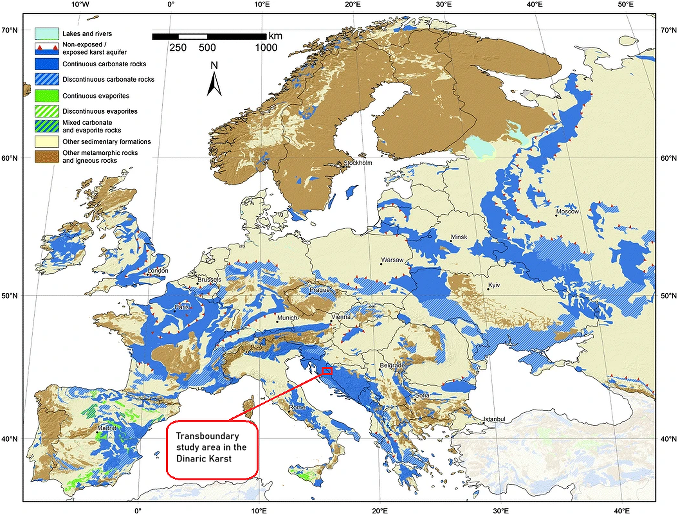
Karst aquifer map of Europe with indicated study area of Klokot's TGC located in the Dinaric Karst within the transboundary aquifer Una between Croatia and Bosnia-Herzegovina (Chen et al. 2017, 781, Fig. 9, edited by author).
The term karst denotes both subterranean and surface landscapes of highly permeable carbonate rock formations—such as limestone, gypsum, or dolomite—that dissolve through groundwater in a process known as karstification. Water at the surface percolates through fissures and cavities into subterranean conduits that can carry groundwater over large distances with high velocity. Groundwater in karst landscapes is regarded as difficult to manage compared to other aquifer types, as addressed by hydrology, hydrogeology, and geomorphology (Bonacci 2015). Technoscientific issues in managing karstic groundwater include hydrological uncertainty and unpredictability due to highly variable recharge and flow pathways (Ford and Williams 2007). Moreover, rapid infiltration through sinkholes and fractures render groundwater storage and flow unpredictable while heightening contamination risks (Hartmann et al. 2014; Goldscheider and Drew 2007). Climate change further intensifies these dynamics, increasing erosion, droughts, and flash flood risks (Jourde et al. 2014). In short, a lot is at stake in knowing and managing karstic groundwater.
My inquiry begins from my interlocutors’ positioning of karstic groundwater as an unruly object of research and governance. Tracing the unruliness of Klokot's TGC through my empirical material as well as karst scholarship, I follow two analytic entry points from Science and Technology Studies (STS). One foregrounds sense-making practices, in which institutional routines, regulatory instruments, and epistemic commitments (re)produce karst aquifers and their springs’ catchments as unruly. The other emphasizes karst's materiality, where its physical properties defy in-depth hydrogeological modeling and management through material unruliness. While appearing at odds, these entry points are intertwined: Klokot's unruliness is a relational property, emerging from entanglements between its material, social, and political dimensions. Unruliness thus points to both the material complexity of karst and the epistemic uncertainties, political frictions and infrastructural gaps that become tangible when governance must straddle a TGC such as Klokot.
This contribution reveals how unruliness materializes in such contexts by outlining hydrogeological knowledge practices and management strategies in Klokot's TGC. In the following, I first discuss the notion of unruliness in STS literature and beyond. Second, I describe Klokot's TGC in its historical and technomanagerial contexts, and introduce its most important sites, before, third, focusing on hydrogeological and political sense-making practices. Fourth, I examine the unruliness of karstic groundwater and Klokot through a material-semiotic lens, concluding by reflecting on unruliness as a form of practical ontology that reframes how certain environments are understood and governed.
Unruly Undergrounds: Studying the Subsurface
Many illuminating empirical examples by scholars in STS, anthropology, political ecology, and geography demonstrate how “nature” and nonhuman entities have challenged, evaded, and provoked human attempts at control and management through technoscientific standards (Archer 2015; Gandy 2016; Clifford and Travis 2021). These scholars have described such attempts as marked by uncertainty and indeterminacy (Schrader 2010; Henig 2019; Waterton 2017), unknowability and inscrutability (Kroepsch and Clifford 2022), illegibility (Scott [1998] 2020), and intractability (Collard 2024). While some engage with the environment as unruly, groundwater—and more specifically groundwater in karst landscapes—is not at the center of these works, though there are valuable insights to draw from this “invisible resource.” Hence, understanding unruliness in relation to groundwater involves exploring the scientific knowledge practices that seek to understand it, the management practices that aim to govern it, and the interrelations between both.
Unruliness refers to the resistance from entities, infrastructures, or ecologies to stabilization and control within dominant frameworks of governance and epistemic practices, emerging at the intersection of nature's agency and human intervention. Unruliness as a concept transcends mere recalcitrance, embodying nonhumans’ inventiveness and defiance of expectations. Attempting to tame nature through colonial and capitalist endeavors often backfires and gives rise to intractable and unpredictable landscapes that challenge human hegemony (Tsing 2012, 2015). Such unruliness disrupts material and discursive boundaries, defying attempts at control and categorization (Collard 2024). Krishnan, Pastore, and Temple (2015, 5) define unruly environments as “places difficult to control and categorize, whether choked with vegetation, submerged underwater, or encased in concrete.” Moreover, they describe how notions of unruliness are linked to questions of environmental materialities, agencies, and hegemonic attempts to render environments governable. They conclude, “unruliness emerges when environmental conditions disrupt human efforts to impose order” (Krishnan, Pastore, and Temple 2015, 7). Other authors add that a nonlinear or disrupted state-building effort, be it in the context of infrastructural projects, environmental histories, or enforcing hegemonic modernity, contributes to a stronger sense of unruliness (Pastore 2015; Parasher-Sen 2015). The idea that environments are unruly is often invoked in situations and settings where nature is conceived as fundamentally unmanageable (Taylor 2005). For example, Martinez's (2023) study of toxic terrains in the Tijuana River basin highlights the social–ecological consequences of attempts to manage unruly landscapes. The perception of the river as unruly by US and Mexican officials reflects its defiance of containment and control. Hence, efforts to rehabilitate such landscapes often result in the marginalization and stigmatization of vulnerable communities, exacerbating social inequalities. Disciplining ecologies in the service of capital accumulation further entrenches forms of domination over both environments and people, and perpetuates environmental injustices (Martinez 2023).
Simultaneously, the notion of unruliness is always tied to questions of what knowledge of the environment exists (Scott [1998] 2020; Barry 2021), how this knowledge is generated, and how it manifests in infrastructures and practices used to render an environment manageable (Carse 2012; Blok, Nakazora, and Winthereik 2016). In turn, such infrastructures and their ruins can also “become sites for unexpected, unruly ecologies” (Kurtiç 2023, 146), wherein their indeterminacy rearranges relations and land-use practices, for instance in areas containing landmines (Henig 2019); indeterminacy pushes us to rethink the relationship between knowledge, power, and politics (Waterton 2017). Such rogue infrastructures (Kim 2016) hold spatiotemporal power over practitioners, among others. Just so, groundwater and its “radical material indeterminacies” (Ballestero 2016, 51) manifest in hydrogeologists’ struggles to clearly delineate the borders of an aquifer or groundwater catchment area, which, in the case of Klokot spring, is further complicated by its transboundary setting. Hence, aquifers can be framed as uncooperative in human attempts to know and manage resources, and unruly aquifers and infrastructures can in turn tell us “as much about our historical and cultural attentions in a particular moment and place as [they do] about the thing itself” (Howe et al. 2016, 6). Approaching unruliness conceptually therefore also means to trace its relation to indeterminacy, illegibility, and intractability, as they all seem to share a resistance to modern forms of control such as scientifically driven technopolitics, infrastructure projects, or statecraft (Agrawal 2005; Birkenholtz 2009).
Attention to the underground in STS has been increasing as scholars tease out and analyze entanglements of technoscience, economics, politics, and culture shaping the subterranean world. Kinchy, Phadke, and Smith (2018) introduce this emerging field by highlighting the focus of STS scholars studying knowledge, work, and place-making activities. Instead of understanding it as a fixed or inert space, they argue the underground comes into being through a complex web of processes and practices. This includes a deep entanglement of the subterranean with global markets, resource extraction industries, and financial speculation. Simultaneously, underground governance is a contested arena where nation states, corporations, and communities negotiate access, control, and regulation over underground resources such as oil, gas, and minerals. By emphasizing the sociotechnical nature of the underground, STS researchers have begun unveiling issues of knowledge, expertise, and power to suggest that its character is determined by both biophysical properties, technoscience, and concomitant human interactions (Kinchy, Phadke, and Smith 2018; Ballestero 2019b).
Following these critiques, I propose that studying groundwater as a resource that is extracted for drinking water, agriculture, and industry can reveal how underground spaces remain sites of scientific and political contestation. The means by which aquifers and groundwater catchments are measured, made visible, and rendered governable include hydrogeological monitoring, such as measuring stations (piezometers) located at various depths (Birkenholtz 2015), supplemented by remote-sensing techniques (Ballestero 2019a) and computational models of aquifer behavior, as well as specific groundwater recharge rates (Brooks 2017; Kroepsch 2018a). Yet, despite technoscientific advancements, disagreements persist among karst scholars, hydrogeologists, groundwater practitioners, and others about the definition of aquifers, the delineation of groundwater catchments, and the inner workings of karst subsurface systems, complicating efforts to govern groundwater resources effectively. Groundwater models, where they can be developed, do not merely work as simulators but as tools that actively shape subsurface politics and social–ecological consequences (Kroepsch 2018b). Contributions to this strand of STS scholarship highlight the hybridization of technical and local knowledge by examining the significance of diverse expertise in shaping underground realities (Birkenholtz 2018). Considering these approaches is essential for understanding how groundwater catchments are delineated, debated, and managed across political borders. Against this background, Klokot's TGC offers a compelling case to explore how unruliness is both enacted and contested through situated hydrogeological practices and regulatory efforts.
Klokot, the 17th Lake of Plitvice, and an Abandoned Military Airport
Post-Yugoslav environments have been subject to a fundamental administrative fragmentation following the dissolution wars of Yugoslavia throughout the 1990s. Natural resources that had been managed uniformly were rendered transboundary objects of management. As hydrogeologists argue, one of the biggest problems for sustainable groundwater management in the region is that the formation of post-Yugoslav nation states “has established complex transboundary inter-linkages that impact water use and water sharing for domestic supply, power generation, and agriculture” (Stevanović, Krešić, and Kukurić 2016, ix). This is the case for Klokot, a TGC in the transboundary aquifer Una, located at the northwestern border between Bosnia and Herzegovina and Croatia. Klokot comprises the two karst springs: Klokot I and II. Klokot I is one of Bosnia and Herzegovina's largest karstic groundwater springs (Skopljak and Mulaomerović 2012) and the most significant drinking water source for Bihać municipality. Additionally, Klokot I is the spring of a river of the name Klokot, a left tributary of the river Una, Bihać's renowned symbol. Klokot emerges at the foot of a steep slope that leads up to the Željava plateau, home to the abandoned, now transboundary Yugoslav military airport LYBI Bihać, colloquially known as Željava. This transboundary airport featured a massive tunnel compound built into the underground of the Plješevica mountain range, behind which lies the UNESCO-protected Plitvice Lakes National Park (PLNP) in Croatia. Via extensive subterranean karst conduits, the subsurface of PLNP's northeastern area is connected to Klokot I and II, and other groundwater springs in the Una aquifer (Babinka 2007; UNDP and UNESCO IHP 2013b; World Bank 2020).
Klokot's TGC is embedded in dense conflict histories. From the sixteenth to the eighteenth centuries, the Imperial War Council in Austria carved out and managed large areas of Croatia adjacent to the Ottoman Empire for the creation of a military frontier, which served as a buffer zone between the Ottoman Empire and the Habsburg monarchy (Popescu 2024; Pavelić, Petrić, and Radošević 2024). As a military frontier, the area was inhabited sparsely. In the late nineteenth century, remaining military infrastructure facilitated early touristic development, particularly around the Plitvice Lakes, and as military presence decreased, conservationists established a protected area around the fragile lake system. In Yugoslavia, both environmental protection and tourism in the PLNP area increased once the PLNP became a national park and part of UNESCO's heritage network in 1979 (Figure 2).

End of the lower lake system of the Plitvice Lakes, featuring its highest waterfall. Photograph by the author, August 2022.
With the construction of Željava Air Base between 1965 and 1975 (Garasic 2021, 363) there came large infrastructural and demographic developments. Supply infrastructure to Željava included two extensive underground pipe systems from Bihać to the Air Base, which supplied the airport with kerosene from an army base in the city, as well as groundwater from Klokot I. Home to a Yugoslav Space Program bureau, a satellite information center, and huge underground military tunnel compounds built to withstand even a nuclear attack, Željava provided employment to many people in the region and beyond (Hromadžić 2024). During the 1990s wars in Croatia and Bosnia and Herzegovina, Željava was largely destroyed by both the Yugoslav People's Army and Serb military forces to prevent their adversaries from utilizing the airport's resources. Still, as locals told me, the base ruins served as a transfer point for soldiers, military gear, and contraband, as well as an encampment of army deserters, Croats, and Bosnian Muslims. During this time, pro-Serbian forces also claimed the PLNP's resources: touristic accommodation infrastructure as lodgings, fishing for food, and forest for firewood. Consequently, UNESCO added the PLNP to the List of World Heritage in Danger (1992-1997).
Two decades later, in 2018, the World Heritage Committee considered adding the park to this list again, with UNESCO observing direct links between unsustainable touristic development and detrimental effects on the local hydrogeology (WHC and IUCN 2017) were threatening the “Outstanding Universal Value” of the Plitvice Lakes. Constructed in the 1960s, the local wastewater infrastructure could not support mounting visitor numbers and a sewerage collection plant discharged unfiltered sewerage into a nearby karstic sinkhole. As the sheer volume of the discharged wastewater could not sink into the underground as quickly as before, it filled up the entire sinkhole (see Biondić, Meaški, and Biondić 2016; Vale 2018; WDR 2018); consequently, Escherichia coli and fecal coliforms such as fecal streptococci found their way to Klokot's spring site (World Bank 2020). In reference to the famous 16 cascading lakes, the sinkhole formed a septic lake that was locally dubbed “the 17th lake of Plitvice.”
Since the end of the 1990s wars, the area was subject to shifting border regimes. First, it became a transboundary catchment between the new state borders of Croatia and Bosnia and Herzegovina; then with Croatia's subsequent European Union (EU) accession, it became a site of the EU's external border. As the transboundary airport area was partially demined on the Croatian side in 2018, Željava was increasingly utilized to reinforce the EU's brutal border security regime (Davies, Isakjee, and Obradovic-Wochnik 2022). Moreover, the changing regimes, conflicts, and land-use activities aboveground have had a lasting impression on its subterranean world, with both diffuse and point-source pollution due to unmonitored landfills, military waste, inadequate wastewater treatment, and leaky septic tanks. These layered histories of imperial militarization, socialist infrastructural ambition, war, and postwar border securitization have marked Klokot's TGC. Aboveground, shifting sovereignties and border regimes have continually redrawn the terms of access, jurisdiction, and monitoring. Belowground, these changes were mirrored in a hydrogeological system that resists delineation, complicated by contamination, infrastructural decay, and the groundwater flows that connect the UNESCO-protected area to a spring across the border. Hence, Klokot's unruliness is not merely a matter of karstic complexity, but a product of the ways in which political borders, infrastructural legacies, and hydrogeological uncertainties become entangled. It is at the edges of these entanglements, where governance systems strain to stabilize an environment, that the work of making sense of Klokot hydrogeologically and politically takes shape.
Making Sense of Klokot: Infrastructuring Indeterminacy at its Edges
Water-related issues are often framed through number narratives (Brooks 2017), with numerical stories making sense of and simplifying the quantification of water needed for its technolegal legibility. But in karst, it is less the quantification than the groundwater quality and catchment delineation that is at the core of management issues (Bonacci 2004; Bakalowicz 2005). While many conceptual models of karstic aquifers illustrate general components of karst systems, the effectiveness and local adequacy of conceptual and numerical models in karst is disputed (Bakalowicz 2005, 155). Karstic groundwater regimes are “still not properly delineated and characteristics of deeper aquifer parts not studied in detail” (Stevanović, Krešić, and Kukurić 2016, 19). Simultaneously, the disparities between topographic and hydrological groundwater catchments in karst landscapes are “so large that data about the topographic catchment are useless in hydrological and hydrogeological analyses,” rendering the boundary determination of karstic groundwater catchments an “extremely complex and sometimes unsolvable task” (Bonacci, Željković, and Galić 2013, 964). Tracer tests—where dye is injected into the soil or water to trace its paths—form the main method for delineating karstic groundwater catchments (Babinka 2007; Goldscheider et al. 2008). Consequently, these point-to-point connections are the markers through which a border delineation of the groundwater catchment is mapped.
Klokot's TGC does not have a long subterranean data history. In Yugoslavia, the first tracer tests that established interconnections within Klokot's TGC were performed between the late 1970s and 1980s (Babinka 2007, 38; UNDP and UNESCO IHP 2013, 82). However, continuous, reliable discharge data for springs was missing due to the 1990s wars and their aftermath. Several research projects in the postwar period brought this into focus. In fact, two hydrogeological studies conducted in 2005 claim to have first established a direct connection of water flow between the Plitvice Lakes and Klokot spring, by studying water losses at Korana river, the beginning of which forms at the end of the cascading Plitvice Lakes (Biondić, Meaški, and Biondić 2016; World Bank 2020; Radišić et al. 2021). Until then, these flow directions “were only presumed, but were practically unidentified. Namely…it was not possible to claim with certainty that the area was connected with the Klokot source” (World Bank 2020, 63). Another crucial data reference point was an EU research project investigating postwar anthropogenic pollution in the border area conducted from 2002 to 2006 (Institut Ruđer Bošković n.d.; Babinka 2007), wherein researchers similarly conducted tracer tests to assess the status and vulnerability of the TGC's ecosystem (Babinka 2007). Although the project recommended further tracer experiments to establish hydrodynamic characteristics and sanitary protection zones, it was not until the transboundary pollution from the “17th lake of Plitvice,” that an updated and extensive delineation of the groundwater catchment took place.
While Croatian and Bosnian media had already covered the ongoing pollution by 2015 (Hromadžić 2024, 78), the issue's escalation came into focus internationally through later statements by UNESCO (WHC and IUCN 2017) and reports by international media outlets (see WWF 2017; Prtorić and Vale 2018; Vale 2018). Attention to the septic lake was amplified as the number of visitors to the PLNP mounted to a record 1.7 million (Ministry of Tourism 2018). In 2018, the German broadcaster Westdeutscher Rundfunk (WDR) documented this local scandal when filming a documentary on the effects of increasing touristification across Croatia (WDR 2018). In this documentary, Plitvice's mayor resolutely observes: “This is the paradox: The park is the biggest protector of nature but is simultaneously its biggest polluter” (WDR 2018 at 18:30-18:38). When I interviewed him in August 2022, he reflected that he had been trying to raise awareness and increase pressure on the PLNP management and the responsible state authorities long before 2017. Here, concerns aligned about the increasing accommodation construction boom in the park and its ecological consequences for drinking water across the border. In Bihać, the contamination of the source of its drinking water supply was understood as “a siege of Bihać from below” (Hromadžić 2024, 78); a reminiscent war-time logic where targeted pollution of vital resources was common (Figure 3).

Graffiti depicting the UNESCO logo sprayed at the Plitvice Lakes National Park (PLNP)'s wastewater collection plant by local inhabitants in protest against the septic lake. Photograph by the author, August 2022.
Under international attention, such extensive contamination prompted a re-examination of transboundary protection measures, which sparked renewed regulatory interest in Klokot's TGC. Consequently, a study financed by the EU, its Western Balkans Investment Fund, and the World Bank, sought to define and advocate for mitigation measures, such as a new wastewater filtration system at the PLNP and new cross-border sanitary protection zones for the affected springs in Bosnia and Herzegovina (World Bank 2020). One key outcome of the study was the establishment of new groundwater catchment borders for Klokot spring, with the recognition that these delineations might again change in the future due to land-use practices detrimentally affecting the groundwater ecosystem and quality. The study showed for the first time the astonishing extent to which Klokot's TGC stretched beyond the Bosnian-Herzegovinian border. During the postwar shift to national sovereignty, the catchment became transboundary by default before a coherent scientific understanding of the entire groundwater catchment was even established.
In the immediate postwar period, in 1996, the newly formed sovereign states signed a bilateral agreement of shared water resources (Official Gazette BiH 1996). Notably, for Bosnia and Herzegovina, it remains the only bilateral agreement for transboundary water sources with one of its neighboring states. One senior civil servant of a Croatian state water authority portrayed the evolvement of groundwater management from Yugoslavia as follows: We have the misfortune of that cursed war that we first fought, and then we were divided into states. Now, as karst has huge conduits, more or less all [aquifers] have become cross-border.…Until 1986, everyone did it their own way, and in 1986 the first legal regulations appeared [for groundwater] where, based on specific situations, each researcher will set their own criteria for management.…Each state has their own regulation now. But the problem is that everyone had their own guru before the war…countries declared [their work] as the legal regulation and that's all wonderfully beautiful until you connect those two countries at the border. (September 26, 2022)
However, at PLNP, an additional wastewater treatment facility was built that guaranteed a higher filtration level before discharge into the sinkhole. The sinkhole was fenced off, and the PLNP management had referred the responsibility for water and wastewater infrastructure to the local water utility company. Simultaneously, my interlocutors at the water utility company Bihać claimed that the new facility had been and would be switched off outside of the tourist season. This, in turn, would follow the presumption that the total volume of groundwater in the catchment would contribute to dilute contaminants to the extent that they would remain uncritical to current drinking water quality standards. Moreover, the territorial distribution of the groundwater catchment introduced another dynamic around the World Bank study, as the same Croatian civil servant concluded: We handed over the documents to the people responsible. But you know, this is just one catchment. All other transboundary catchments south of Klokot with the border to Bosnia, the case is reversed! The bigger part of the catchment for many of our most important coastal karst springs lie in Bosnia, where they are also polluted. So, we thought, come on, we can take a step toward them in this issue. Maybe then they will also accommodate us later for the other catchments. (September 26, 2022)
Yet, the cross-border character of Klokot's TGC was already acknowledged in 2004, when the first postwar documentation was prepared for the establishment of cross-border sanitary protection zones. This study established a catchment size distribution of 13.8 percent in Bosnia and Herzegovina, and 86.2 percent in Croatia (Institut za hidrotehniku 2004). Strikingly, the 2020 study pushed this asymmetry in territorial distribution further, reducing Bosnia and Herzegovina's share to just 10 percent compared to Croatia's 90 percent (World Bank 2020, 37)—a distribution with profound implications for transboundary management. Thus, while the study resulted in updated hydrogeological assessments, it also reinforced an ongoing reliance on issue-driven research and consultancy projects funded by international donor organizations to generate hydrogeological knowledge applicable to the management of Klokot's TGC (Figure 4).

Map of the Klokot groundwater catchment (bold pink line) as indicated by tracer tests showing the suggested drinking water protection zones in different colors (Ia-IV). The depicted tracer tests indicate connections (thin full pink arrow lines) and no connection (thin dashed pink arrow lines) between different measuring points. The map includes the nation state border (bold dark gray line) between Croatia (on the left) and Bosnia-Herzegovina (on the right), and the border of the Plitvice Lakes National Park (green line). The map shows the transboundary Klokot Catchment, as indicated by the groundwater connections crossing the nation state border (thin full pink arrow lines) (World Bank 2020, Annex 4, Vol. 5, edited by author).
In other interviews, the World Bank (2020) study was framed as another impracticable attempt to resolve the catchment's unruliness, as it concluded like previous projects that more data, more groundwater monitoring, transboundary harmonization of data, exchange between stakeholders, and a deeper understanding of the local karstic groundwater behavior were necessary (see Babinka 2007; Stevanović, Krešić, and Kukurić 2016). Moreover, my interlocutors critically questioned why it took such a peak contamination for the PLNP to engage in mitigation and prevention measures. For one, suggestions for transboundary sanitary protection zones for the Klokot spring were already in place, and hydrogeological studies had shown the interconnectedness of groundwater flow in the border region before the contamination reached such a dramatic extent. Furthermore, other researchers had already picked the Plitvice–Klokot connection as an example in arguing for stricter “enforcement of already established sanitary protection zones and preventive measures” (Stevanović, Krešić, and Kukurić 2016, 20-21). In fact, the danger of pollutants emerging at Klokot has been known since the 1980s. Both the potential harm of environmental toxins like polychlorinated biphenyl, military waste from Željava (Picer et al. 2004), and illegal landfills in Bosnia and Herzegovina and Croatia were clearly identified as hazardous to Klokot's water quality (Babinka 2007).
Nonetheless, although scientists, water authorities, and the two affected water utility companies had been aware of the issue, the water utility companies reported a lack of financial, institutional, and political support to find appropriate infrastructural solutions, such as purchasing additional filter systems for the sewage system and for drinking water disinfection. Considering this, the mismatch between those with such kind of uncomfortable knowledge (Rayner 2012) of the issue, those responsible, and those able to facilitate mitigation measures contributed even further to the unruliness of Klokot's TGC. This opacity echoes that when confronted with unruliness, “boundaries and notions of jurisdiction become blurred…routines and rules of decorum erode” (Pastore 2015, 61). This pertains as much to the establishment of Klokot's transboundary sanitary water protection zones as to its catchment delineation.
The efforts by water authorities, researchers, and policy consultants to map and manage Klokot as a TGC—especially along its elusive edges—represent attempts to reduce or eliminate its indeterminacy, trying to transform the ambiguous and dynamic karstic groundwater and its subterranean world into a legible, governable space. Following Ballestero (2019b), understanding Klokot's TGC as infrastructure foregrounds how such hydrogeological knowledge becomes entangled with broader political and epistemic orders, as the act of delineating a groundwater catchment is never outside of politics. Klokot's TGC makes visible a paradox at the core of such work: it is a site of contestation where knowledge claims compete, responsibilities shift, and borders blur. Klokot's management began long before its scientific and spatial extent was established, producing a governance regime whose object was only partially known. As Taylor (2005) argues, such “unruly complexity” arises from historically layered situations embedded within wider societal dynamics.
At Klokot, this dynamic is intensified by its transboundary character, where some practitioners claim that mismatched regulatory frameworks render karstic groundwater unruly—not in itself, but through the political frictions it engenders. This also resonates with Oguz's (2023) concept of “speculative undergrounds” in southeastern Anatolia, where geological uncertainty invites competing geopolitical and national imaginaries. Similarly, in Rahder's (2015) account of contested water basins in Guatemala, competing cartographies reveal how scientific tools are enlisted both to claim authority and to cope with the “out-of-controlness” of ecologically and politically dense terrains. The various research projects and diverging interpretations of their buy-in and outcomes construct Klokot's TGC as politically and socially unruly to suit specific narratives and geopolitics. Yet even as scientific knowledge about Klokot increases and (waste) water infrastructures expand, the karstic TGC continues to evade systematic, vertical, nation-state regulation. Focusing on the practices of hydrogeological and political sense-making of Klokot's TGC shows that unruliness is not simply a synonym for complexity or uncertainty. Rather, unruliness describes how material, political, and epistemic claims coproduce environments that resist stabilization, demanding forms of governance that remain contingent, negotiated, and incomplete. It is in the persistent negotiation and lived relations with unruly aquifers that groundwater practitioners enact a form of unruly management—adaptive, situated, and grounded in the uncertainties they seek to govern.
Karst and its Arteries: Ontological Implications of Karstic Materialities
“Is karst an aquifer?” This question by noted French karst scholar Michel Bakalowicz (2020, 55) cuts right to the chase, as conceptions of groundwater in karst vary both locally and within karst scholarship. What he described as “karstschizophrenia” elsewhere (Bakalowicz 2005) outlines two distinct approaches to understanding the relationship between groundwater and karst landscapes. One conceives karstic groundwater as an aquifer with storage capacities, while the other conceives it in a state of permanent flow, rejecting the notion of aquifer. While the first approach neglects the hydrogeological functions of conduits and caves in karstic undergrounds, the second approach acknowledges them, putting emphasis on speleological explorations for understanding their impact on karstic groundwater flow (Bakalowicz 2020).
Despite such contingent conceptions of karstic groundwater, some natural sciences researchers describe the materiality of karst with agential capacities. In this vein, linguistic markers employed in describing human bodies and their agency are transferred to a karstic groundwater body, for instance by describing the underground conduit and cave system in karst landscapes as an “artery network type of permeability” (LeGrand 1983, 347). Meanwhile, Bakalowicz (2005, 154) proposes “integrating a ‘medical’ approach of karst systems similar to a physician's [approach] when making a check-up followed with a diagnosis” in studying karst hydrogeology. This hallmark publication by Bakalowicz (2005, 151) distinctly attributes karstic groundwater agency by describing how “karst processes ‘select’ some of the original discontinuities, fractures, joints, bedding planes or macroporosity, developing a hydraulic continuum from surface to spring.” Here, he explicitly describes the flow pathways and process of karstification as a site-specific choice, stating that classical hydrogeological modeling is not sufficient for karstic groundwater catchments “because groundwater flows ‘take a choice’ based on both the connectivity of the discontinuities and the hydraulic gradient existing between the recharge area and the location of the spring” (Bakalowicz 2005, 154).
Several aspects come together here that unsettle clear-cut definitions of karstic groundwater: karst's ambiguous status as an aquifer, the unknowability of karstic undergrounds, and the agential capacities ascribed to them. While hydrogeologists continue to explore and advance methods to increase the legibility of karstic groundwater, the practitioners who manage it every day are equally confronted with its unruly materialities. At the Klokot I spring site, groundwater management practitioners and speleologists negotiate embodied and scientific knowledge about the karstic underground. As such, they are “people who undertake work in close physical proximity with aquifers and groundwater, deploying and generating knowledge and conceptualisations as they do so” (Cleaver et al. 2023, 172). While there are many specific terms for particular karstic formations and groundwater bodies varying locally, my interlocutors never described Klokot I in relation to the transboundary Una aquifer, even though it is embedded in the northeastern part of the aquifer. Instead, groundwater management practitioners and researchers used the term “catchment area” or “groundwater basins,” analogous with river basins and river catchments. Some field staff of Bihać's water utility company described Klokot as a ponornica, a subterranean or sinking river characteristic of karst landscapes, further challenging the conceptual relation between aquifer and groundwater catchment. One of them explained it like this: I know that there is no river at the Plitvice Lakes that goes underground and then comes out again here at Klokot. But Klokot comes out already as a river because there is something like a tunnel in the ground! So is the spring of the river already underground? But the water that comes out at Klokot is already connected to other water, the [Plitvice] lakes, even the [Korana] river; over the last several years they have been saying that it goes underground even more, and who knows what other water is mixed on the way to Klokot here. (Fieldnote, July 17, 2022)
This ambiguous relationship between different scientific and political terminology is reflected across scientific studies, groundwater policy and related reports. For instance, the 2016 UNESCO-led project that re-established the Una transboundary aquifer, based its aquifer delineation methodology on two principles. First, that “each transboundary aquifer belongs to one of the main transboundary river basins or lakes” according to the EU's Water Framework Directive (WFD) (UNDP and UNESCO IHP 2013b, 79), namely the Una river for the Una transboundary aquifer. Second, that these transboundary aquifers cover the recharge areas of karst springs identified within such transboundary river basins or lakes. However, they also note that “due to complexity of karst and limited data availability, the estimated boundaries are approximate in their nature.” Meanwhile, the WFD in its definitory power distinguishes groundwater as “all water which is below the surface of the ground in the saturation zone and in direct contact with the ground or subsoil” (European Parliament and Council 2000, 10). Further, it specifically defines aquifers in terms of a “subsurface layer or layers of rock,” and a groundwater body as “a distinct volume of groundwater” within an aquifer (European Parliament and Council 2000, 10-11). By contrast, a definition of groundwater catchment is missing in both the WFD and its subsequent daughter directive on groundwater (European Parliament and Council 2006), as are any specifications that address surface and groundwater bodies in karst landscapes.
On the ground, the field staffers, much like scientists, highlight the multiplicity and fluidity of karstic groundwater, acknowledging how underground groundwater flow pathways challenge conventional hydrogeological categorizations. Recognizing this complexity, scientists have increasingly argued for direct observation methods, criticizing traditional approaches that focus solely on inputs and outputs, which thereby fail to capture the dynamics of karstic groundwater catchments. Here, the attention shifts toward the potential of speleological explorations—directly observing the unruly object—suggesting that “[c]aves offer the opportunity to directly observe what is happening at the karst aquifer” (Goldscheider et al. 2008, 27).
At Klokot, a common reference to such an observation is a story about French speleological divers who undertook an expedition into Klokot I's subterranean karst conduit system in the early 2000s, trying to reach a new depth at every revisit. In local retellings, during these dives speleologists saw “huge underground lakes” and “dark openings.” Considering there was no extensive groundwater catchment delineation for Klokot spring at the time, it was reportedly “intriguing” to see whether the speleological divers would succeed in mapping Klokot from within. Although Klokot surfaces at the foot of a high slope, the spring is ascending and from below “emerges from almost vertical surface caves” (Skopljak and Mulaomerović 2012, 27), an insight which resulted from these expeditions. One field staffer at Klokot who witnessed the divers described how: For a while, divers used to come to see if they could dive into Klokot. They… would…go in again for a bit longer, then again out, then again in and so on.… They had special instruments so that they could actually get deep into the water and not remain on the surface. But even they didn’t get deeper than around 100 meters or so! They said that they saw other large openings and that when they reached the deepest point they could reach, they saw that the corridor actually went up again! So no one knows what actually is down there, or up there! Who knows how much water there is. We only know that we have to take the water as it arrives here at Klokot. (Fieldnote, July 20, 2022)
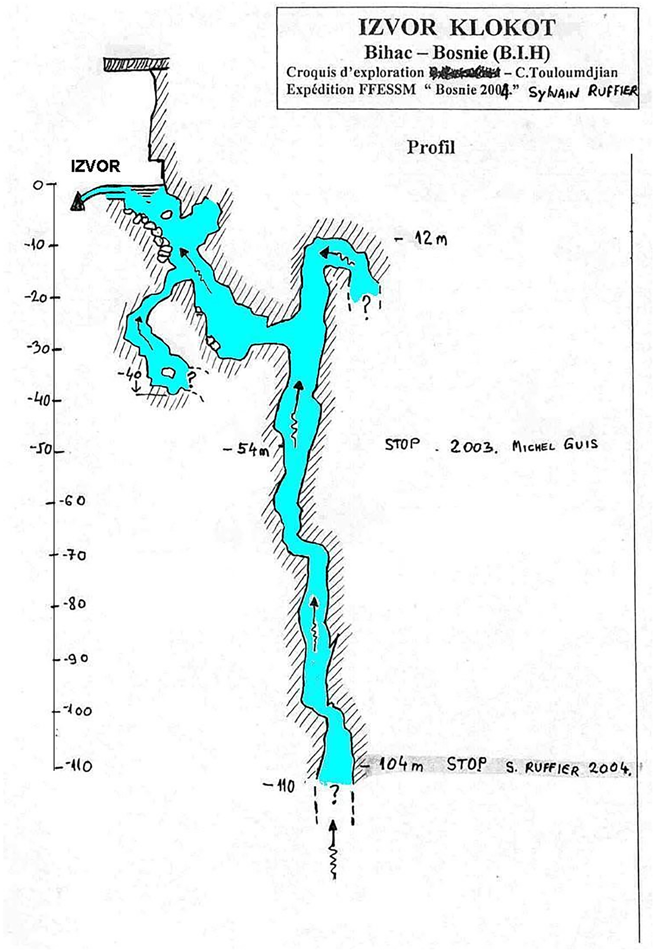
Conceptual model of the karst conduits leading up to the Klokot spring. Markers in the model show the depth reached by the speleological divers with each dive. In 2004, the so far deepest point was reached at 104.5 meters into Klokot spring. Photocopied for the author by an informant, July 2022.
The divers, groundwater practitioners, and karst scholars alike remain perplexed by the indeterminacy pervasive in Klokot's TGC, not only when investigating what its karstic groundwater does but also what it is, and how it can be understood in its doing and being. Instead of asking “is karst an aquifer?” one might very well ask “what is karst?” It is in the interaction between groundwater and the karstic subterranean that underground conduit networks are formed in a process called karstification. Due to the high solubility of the carbonate rocks constitutive of karst, the underground, including its fractures and conduits, is dissolved, shaped, and enlarged by the interaction between the carbonate rocks and CO2 (from soil and the atmosphere) in the groundwater (Xanke et al. 2024, 1398). Subsequently, groundwater coproduces karst formations as they in turn coproduce karstic groundwater, becoming inseparable and never fully knowable. This “ontological indeterminacy” (Schrader 2010) provides the circumstance in which the relations between the karstic underground, groundwater, and knowledge practices are constitutive of each other in their environments. Schrader (2010, 283, original emphasis) introduces this concept discussing the case of the fish-killing microorganism Pfiesteria piscicida to conclude that it is due to its “material agency, not only to react to an environment, but also to co-produce and transform ‘themselves’ in relation to ‘their’ environment.” Just like Pfiesteria, “there is no moment in time” in which karstic groundwater catchments “could be captured in their entirety” (Schrader 2010, 283). Despite studies, expeditions, and tests, what happens underground within Klokot's TGC cannot be known in its entirety, just as its unruliness cannot be resolved or managed away. Neither is this unruliness merely a knowledge gap that can be closed by further research. This illustrates the ontological inadequacy of karstic groundwater as an object of technoscientific practices of knowledge production. Instead, the conception of karstic groundwater is questioned and negotiated in practical dimensions of (non)scientific knowledge production as well as in the management of the resource.
Hence, “unruly Klokot” is not simply an obstacle to be overcome. Here, unruliness is a relational condition, emerging from the mutual constitution of karst's material affordances, the epistemic practices that seek to render it knowable, and the political arrangements through which it is governed. The indeterminacy of Klokot's TGC is not merely a deficit of data but an active feature of the groundwater's being and doing: conduits, flows, pollutants, and even regulatory boundaries shift in ways that refuse fixed delineation. The flows of groundwater, pollutants, data, and regulatory authority cross the border between Croatia and Bosnia and Herzegovina, link field technicians, municipal water suppliers, international consultants, scientists, and subterranean karst conduits. These interactions, unfolding both above and below ground, produce Klokot's groundwater and its catchment as unruly in ways that are inseparable from its transboundary position. This makes unruliness a critical notion for studying the relationships between surface and subsurface in STS. Not only does it allow us to trace why governance falters in managing groundwater that is “unruly just like us,” to return to the words of the Croatian mountain rescue service worker. It can also guide our understanding of how unruly aquifers challenge and resist categorizations that management (re)produces.
Conclusion: Unruliness as Practical Ontology?
In this article, I have explored the unruliness of Klokot's TGC and its implications for knowledge production and groundwater management. As the empirical examples have shown, karstic groundwater is materially elusive, conceptually unsettling, and indeterminate—in short, unruly. Its flows defy conventional hydrogeological frameworks and regulatory practices suited to other aquifers, underscoring the challenges of governing natural resources that resist categorization and control. Such unruliness is not simply a matter of karst's material properties but emerges in interaction with the social, political, and epistemic practices that attempt to grapple with it. From civil servants insisting that there are no rules in karst systems, to divers that could not reach its subterranean depths, Klokot demonstrates how unruliness is not a passive, inert feature of nature but materializes simultaneously in embodied practice, institutional discourse, and scientific research. In this sense, Klokot's unruliness could be understood as a form of practical ontology (Gad, Jensen, and Winthereik 2015; Jensen 2021); a product of the interaction between the material world, the social practices that seek to govern it, and the entanglement of humans with nonhuman entities and their materialities. Such ontological complexity—where material properties resist clear categorization and stable understanding—shapes the practices of those who work with the environment as well as the way it is represented.
Rather than using unruliness as a catchall for environmental complexity, this article demonstrates its analytical value in tracing how unruliness becomes politically and materially productive in transboundary groundwater research and management. Tracing unruliness across these dimensions highlights not only why governance falters but also how knowledge practices refract. Hydrogeologists’ insistence on karst's irreducible complexity resonates with management practitioners’ struggles with fragmented administrative authority, and both confront limits that cannot be resolved by technical fixes alone. Local skepticism about catchment delineation underscores these limits further, pointing to the disputed effectiveness and persistence of projects to render the underground legible at science–policy interfaces. The unruliness of Klokot's TGC is not merely an abstract feature; it is a site of struggle over epistemic claims and territorial authority that reveals the converging and clashing positions of different actors. Importantly, Klokot's transboundary status amplifies its unruliness, as competing jurisdictions, fragmented data practices, and asymmetric responsibilities render it politically and hydrogeologically uncertain and indeterminate. Mapping this directionality shows how unruliness circulates between science, governance, and everyday practice, continually reconfiguring what Klokot is and how it can be managed. Rather than a stable object of management, these encounters produce TGCs as ever-partial, always-contested environments.
Landscapes like Klokot's groundwater catchment offer a crucial opportunity for STS scholars and environmental practitioners to engage with the material–semiotic dynamics of the world in ways that transcend simple social and material dichotomies. Klokot exemplifies how unruliness can unsettle expert authority, redistribute agency between human and nonhuman actors, and open space for rethinking what it means to govern groundwater in the face of intransigent materialities, particularly in surface–subsurface relationships. Here, unruliness as a concept foregrounds how knowledge, infrastructures, and ecologies coproduce one another in contexts where indeterminacy is not a data or knowledge gap to be closed but a constitutive condition. Attending to unruliness shifts attention from attempts to stabilize or control environments toward the practices, relations, and improvisations through which humans and nonhumans negotiate indeterminacy on the ground. In a world increasingly defined by uncertainty and complexity, unruly aquifers and environments provide a compelling case for developing more flexible, relational approaches to environmental politics—ones that can accommodate the unruliness of both material environments and the epistemological practices that seek to know them.
Footnotes
Acknowledgments
I would like to thank Timo Roßmann, Ruzana Liburkina, and Janine Hagemeister for invaluable comments and inspiring feedback that helped me finalize the paper. The development of this paper has greatly benefited from discussions with Linda Söller, Martina Klausner, Andrea Ballestero, Endre Dányi, Katarina Kušić, and Ognjen Kojanić. I am grateful to the guest editors of this volume, Alessandro Rippa and Matthäus Rest, for their encouraging and insightful comments, and to the four anonymous reviewers of ST&HV, for constructive comments that helped me clarify my argument. Moreover, I am obliged to Dina-Aina Zukić, Sarah Wohlmann, and Mirza Bečević for their research assistance. Special thanks go to Fabian M. Helmrich and the Goethe Research Academy for Early Career Researchers (GRADE) proofreading service for revising the manuscript and improving its readability, and to Carolina Caliaba and Timothy Neale for carefully copy-editing the final version of this article. Above all, I am deeply grateful to all the interlocutors in the field for their generosity and patience throughout my fieldwork.
Funding
The author disclosed receipt of the following financial support for the research, authorship, and/or publication of this article: The research was conducted in the project “regulate—Regulation of Groundwater in Telecoupled Social-Ecological Systems” funded by the German Federal Ministry of Research, Technology and Space (BMFTR) within the framework of the strategy “Research for Sustainability” (FONA, www.fona.de/en) as part of its Social-Ecological Research funding priority (grant number 01UU2003A). The ethnographic fieldwork received further financial support by the Schroubek Fonds Östliches Europa at Ludwig Maximilian University of Munich.