
Abstract
Late pre-Classic Hohokam (A.D. 750–1150) upland desert adaptations of the middle Gila River Valley in southern Arizona are still rather poorly understood. Current site and feature distribution data from Florence Military Reservation indicate that late pre-Classic groups used the upland or bajada zone in a varied and complex manner. First, a variety of agricultural technology was employed, including floodwater farming, dry farming, and to a lesser degree, simple irrigation-based agriculture. Second, a wide range of occupation types have been encountered in these bajada zones, consisting of villages, farmsteads, field houses, agricultural field sites, and more specialized resource processing sites. And, third, a flexible mobility pattern existed, where primary habitations such as rancheria-like villages and small farmsteads were situated along alluvial fans of Cottonwood Canyon Wash. This habitation zone has produced a diversity of floodwater, dry, and irrigation-based farming practices associated with residential areas, trash mounds, and a ball court; the combination of farming technology and presumed ceremonial features may have contributed to group aggregation, at least on a seasonal basis. From this habitation zone, specialized task groups and domestic units repeatedly used field houses and large agricultural fields out on creosote flats, and smaller dry farming loci, on more elevated ridge tops.
Introduction
Late pre-Classic Hohokam (A.D. 750–1150) upland desert adaptations in southern Arizona are still rather poorly understood (Bayman, 2001; Doyel, 1993; Foster et al., 2002; Gregory, 1991; Masse, 1991; Wells, 2003). The primary purpose of this article is to evaluate a series of late pre-Classic occupations from Florence Military Reservation (FMR) in the middle Gila Valley (Figure 1). FMR encompasses 25,228 acres and is situated on the north side of the Gila River, which is located in the Sonoran Desert subdivision of the Basin and Range physiographic province (Pagoulatos 2012a).
Locator map of FMR. FMR: Florence Military Reservation.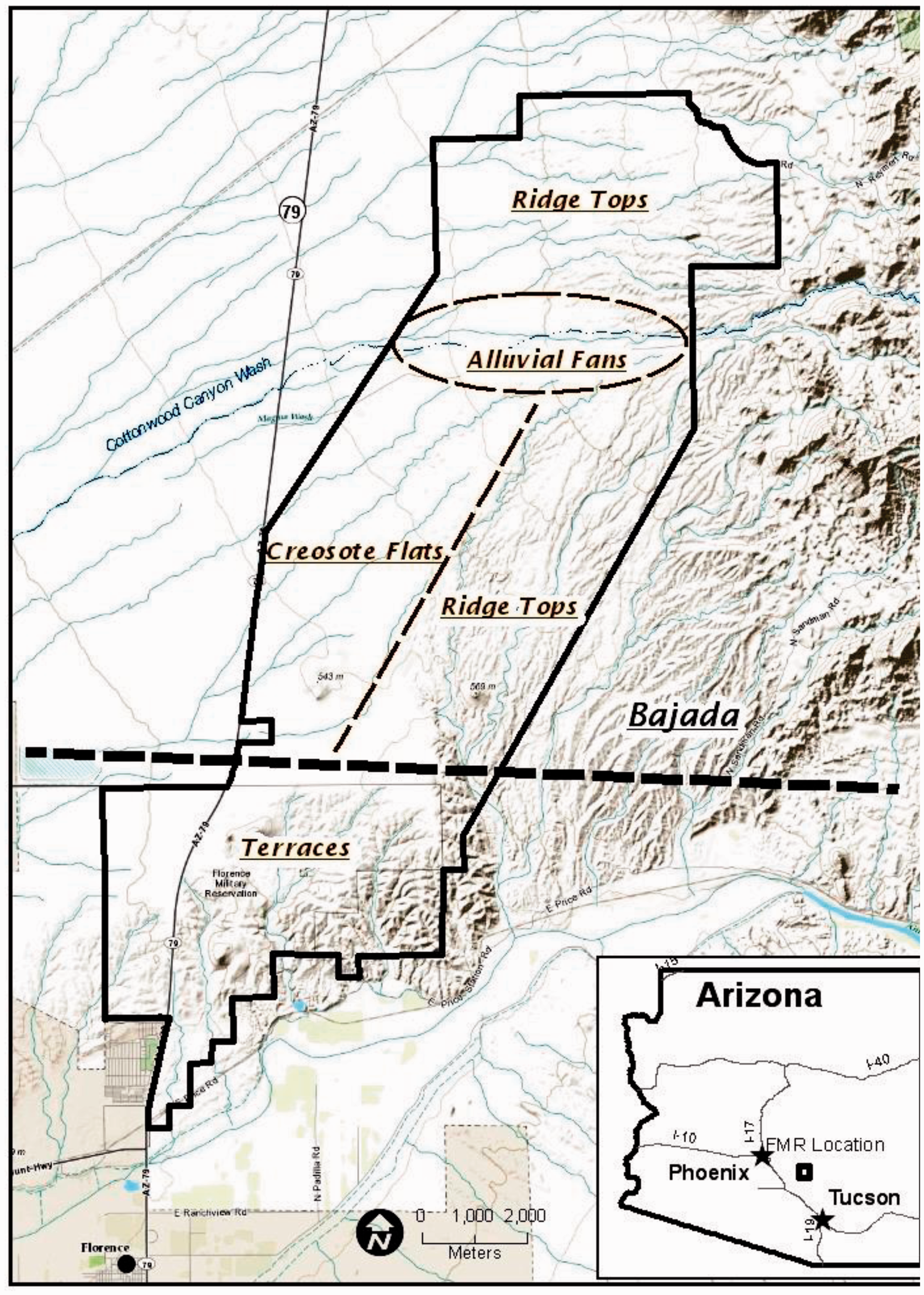
The middle Gila River Valley is primarily characterized by desert riparian zones along the major drainage system and creosote bush vegetation communities along the upper Gila River terrace-bajada zones. Overall, the region consists of four major physiographic zones, the Gila River channel and floodplain, quaternary terraces, bajada plateau and slopes, and the Mineral Mountains; these zones range from about 500 m to 11,015 m above mean sea level. FMR is primarily characterized by terraces and upland or bajada zones (Pagoulatos, 2012a).
The project area lies just to the north of this upper Gila River terrace system, in the upland, or bajada zone associated with the Mineral Mountains. The bajada zone contains numerous intermittent washes, most notably Cottonwood Canyon Wash, the largest such drainage in the project area. The project area lies within the lower and middle bajada slopes, which are characterized by a creosote bush–bursage biotic community. More specifically, the bajada zone at FMR is characterized by three microenvironments: Alluvial Fans, Creosote Flats, and Ridge Tops (see Figure 1). Alluvial Fans are located along Cottonwood Canyon Wash and typically range from 520 to 560 meters (m) above mean sea level (asl). To the south of the wash, lower lying creosote flats typically are about 520 to 530 m asl, while more elevated ridge tops are from 550 to 610 m asl (Pagoulatos, 2012a).
Hohokam culture (A.D. 300–1455) is one of the most well-documented prehistoric cultures in the American Southwest (Bayman, 2001; Haury, 1976). The pre-Classic, in particular, encompasses three major periods: Pioneer (A.D. 300–750), Colonial (A.D. 750–950), and Sedentary (A.D. 950–1150). This study will focus on the Colonial and Sedentary, or late pre-Classic period, since these are the predominant temporal periods within FMR (Pagoulatos, 2012a). During the Colonial (Gila Butte/Santa Cruz phases, A.D. 750–950) and Sedentary (Sacaton phase, 950–1150) periods, site distributions are characterized by settlement expansion from the Gila River into secondary drainages and bajada zones; Gila Butte, Santa Cruz, and Sacaton red-on-buff pottery wares; dispersed (rancheria) pit house villages, complex irrigation canal networks; exotic exchange systems; including the acquisition of exotics such as marine shell, obsidian, and turquoise from distance sources and cremation mortuary practices (Bayman, 2001). Encountered late pre-Classic sites proximate to the current study area include a high concentration of late pre-Classic habitation sites containing ball courts, trash mounds, and possible canal irrigation features, resource processing sites, and agricultural fields yielding rock piles and check dams (Pagoulatos, 2012b, 2013).
The Gila River Valley region is known for well-documented pre-Classic and Classic riverine-based occupations such as Casa Grande (Crown, 1987), Escalante Ruin (Doyel, 1974), Grewe (Craig, 2001), and Snaketown (Haury, 1976). However, until recently, research and cultural resource management studies in nonriverine zones such as those associated with FMR have been underrepresented (Debowski et al., 1976; Doelle, 1975, 1976; Teague and Crown, 1982, 1983). More recent studies of nonriverine zones have produced a variety of late pre-Classic habitation (e.g., villages, farmstead, and field house) and nonhabitation (e.g., agricultural field and resource processing) sites and should be more thoroughly investigated (Criag and Hackbarth, 1997; Deaver and Altschul, 1994, 1999; Doyel, 1993; Foster et al., 2002; Mitchell et al., 2010; Motsinger et al., 1996; Neely and Doolittle, 2006; Vanderspot, 1992; Wells, 2003; Wells et al., 2004)
As part of this current investigation, new data are presented from a recent cultural resource survey of bajada zones south of Cottonwood Canyon Wash. This investigation was a surface survey and was performed by the Arizona Army National Guard to inventory any newly discovered cultural resources within the project area (Pagoulatos, 2013). These newly discovered sites were then incorporated into the preexisting database of late pre-Classic sites from FMR (Pagoulatos, 2012b) and were evaluated and compared using a set of simple quantitative measures to define occupation types. With the establishment of occupation type categories, then these groupings of sites will be interpreted against a variety of land use models.
Methodology
Different types of cultural data will be used to interpret late pre-Classic activities and occupation use in terms of artifact, feature, and raw material diversity from archaeological sites. Cultural data used in this study include: (a) the classification of specific prehistoric artifact, feature, and raw material classes in conjunction with simple statistical methods to discern the range of human (cultural) activities at a site; (b) the establishment of occupation types; and (c) derived land-use models. Each form of cultural data is discussed.
Cultural data
A series of indices are presented to interpret the nature of cultural activities and occupation use in terms of artifact, feature, and raw material diversity. These indices include the artifact grouping index (AGI) , lithic class index (LCI), ground stone class index (GCI), ceramic class index (CCI), mineral class index (MCI), and feature class index (FCI). These simple statistical indices only require the presence or absence of data classes, which is most appropriate when systematically collected artifact density and diversity data are not readily available (see Pagoulatos, 2012b; Wells et al., 2004). Each index is listed below:
AGI: chipped stone, ceramic, ground stone, and shell (worked); nonutilitarian ornaments (beads, bracelets, and pendants); and ceremonial objects (censers, figurines, and palettes) (N = 6). LCI: awl, biface, chopper, cobble tool, core, core tool, denticulate, drill, graver, hammerstone, knife (tabular), pecking tool, projectile point, preform, pulping plane, shatter, scraper, spokeshave, utilized flake, and waste flakes (N = 20). GCI: abrader, anvil, axe, bead, ground stone (unspecified), handstone, lapstone, mano, metate, one-handed mano, palette, pendant, pestle, slab metate, and two-handed mano (N = 15) CCI: buffware (unspecified), Gila Butte red-on-buff, Gila Plain (red variety), Gila Plain (salt variety),Gila Plain (unspecified), Sacaton red, Sacaton red-on-buff, Santa Cruz red-on-buff, Wingfield (plain), and Winfield (red) (N = 10). MCI: andesite, basalt, chalcedony, chert, diabase, diorite, dolomite, granite, greenstone, metasediment, mudstone, obsidian, porphyrite, rhyolite, quartz, quartzite, sandstone, siltstone, slate, and vesicular basalt (N = 20). FCI: activity area, ball court, canal segment, check dam, earthen mound (unspecified), hearth, horno oven, lithic workshop, pit house, pot rest (holder), reservoir, rock pile (planter), rock ring, roasting pit, and trash mound (N = 15).
The artifact grouping index (AGI) is a measure which is designed to assess activity classes across archaeological sites on the basis of specific artifact groupings. The AGI is determined by the presence or absence of six primary artifact groupings, including utilitarian (chipped stone, or lithics, ground stone, ceramics, and worked shell) and nonutilitarian (ornaments and ceremonial items) artifacts from archaeological sites. The AGI is calculated by adding up the total number of different artifact groupings from a single-site assemblage. The AGI ranges from 1 to 6. For example, a site containing only two artifact groupings (i.e., lithics and ceramics) will yield an AGI of 2. In this example, the presence of only lithics and ceramics would likely indicate that rather specialized resource processing took place. By contrast, an AGI of 6 would reflect a wider range of artifact groupings, perhaps representing a more diverse range of cultural activities.
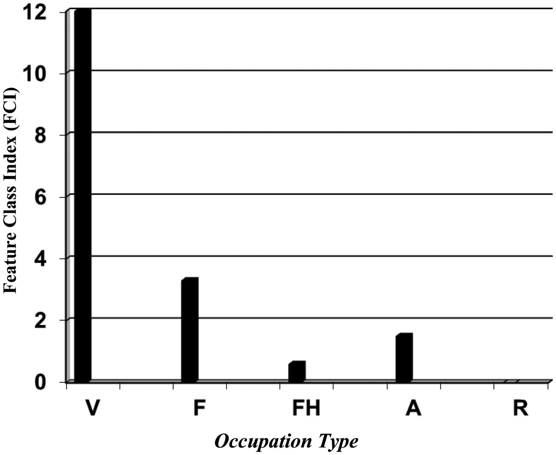
The FCI is used in conjunction with artifact diversity to discern site use intensity and function. In the case of the FCI, feature types are counted for each site using the classification scheme noted above, including agricultural, residential, cooking, trash disposal, water control, and architectural-related features. The FCI ranges from 1 to 15. Each site receives a count based on the number of different feature types present. For example, a site with only hearths would receive a FCI rating of 1, indicating very specialized cooking activities. By contrast, a site with a rating of 15 would reflect a location where a variety of residential, food processing, and agricultural activities took place. Finally, all sites are computed and the total number of feature types is divided by the total number of sites. The FCI is designed to produce the average number of feature types per site. Thus, sites with a high FCI may represent multiple activity sites, while sites with a low FCI are more likely to represent sites with a more limited range of activity.
The LCI and GCI are calculated in a similar fashion. These two indices are designed to assess the range and diversity of lithic and ground stone artifacts from archaeological sites based upon the presence or absence of major lithic and ground stone classes. The LCI ranges from 1 to 20, while the GCI ranges from 1 to 15. These indices are calculated by adding up the total number of different artifact classes from a particular site artifact assemblage. For example, a site containing only two different lithic classes (i.e., projectile points and scrapers) would yield a LCI of 2. In this example, the presence of only points and scrapers suggests that the hunting (and possibly processing) of mammals was an important activity at this location. Therefore, this LCI reflects a rather specialized location where a limited range of activities took place. By contrast, a LCI of 20 would represent a much more variable assemblage, reflecting a wider range of activities.
The MCI is designed to evaluate the range of raw material classes from an archaeological site. This measure serves to address questions concerning raw material procurement and possibly evidence for detected trade systems. The MCI rating is from 1 to 20. For example, a site with only nonlocal obsidian would receive a rating of 1. Although only one type of mineral was found at this site, it would indicate a raw material acquired via either long-distance procurement or trade. By contrast, a site with a rating of 20 would indicate the use of a wide range of minerals, reflecting the use of both local and nonlocal procurement sources. Generally speaking, sites with a high MCI will more likely represent multiple activity sites and which were reused over longer periods of time.
The CCI is primarily designed to assess chronological variability and possibly an indicator of site reuse. The CCI ranges from 1 to 10. For example, a site with only Sacaton red-on-buff would receive a rating of 1. This site would indicate a very limited range of pottery type use and would be indicative of a pottery style that was only in use during the Sacaton Phase of the pre-Classic Sedentary period. By contrast, a site with all 10 ceramic classes would reflect pottery styles extending across the entire Hohokam late pre-Classic sequence, indicating site reuse or occupation.
Occupation types
The cultural data indices are used, in part, as measures of activity variability for the definition of occupation types (an occupation, or site, is defined as any location which yields evidence of past human behavior). These measures of activity variability can be used in combination with other characteristics, such as occupation size, location, and preserved subsistence remains, to define occupation types. The frequency and distribution of occupation types are then used to assess late pre-Classic land use systems. For the purposes of this study, occupation types are broadly classified into two major categories, including habitation (village, farmstead, and field house) and nonhabitation (agricultural fields and resource processing) sites. Each is described in greater detail below.
Village locations are characterized by a wide range of artifact and feature types, indicative of artifact and ceramic manufacturing, storage, subsistence, trash disposal, and socioreligious activities. Structurally, these locations are often formally organized, consisting of residential structures concentrated around plazas, or open space, typical of courtyard groups; several courtyard groups compose a village (Bayman, 2001; Doyel, 1987; Gregory, 1991). Artifact density and diversity tend to be high and cultural deposition can often be deeply stratified, reflecting recurrent and long-term use. Villages tend to contain a wide array of features, such as pit houses, burials, hearths, storage pits, trash mounds, and ball courts. These sites are typically proximate to prominent water sources and consist of aggregate populations, sometimes numbering in the hundreds. Farmsteads often consist of one or two households and tend to be associated with agricultural-related activities, away from village sites. These sites usually contain a rather wide variety of domestic and agricultural features and would be typically occupied on a seasonal, but recurrent basis. Field houses usually contain only one household and are more ephemeral and short term in duration (Gregory, 1991).
Agricultural fields tend to be more specialized in nature, not containing habitation-related features. These sites tend to be situated on good agricultural soils and are typically characterized by the use of canals, check dams, rock piles/planters, and other agricultural-related features. Artifact density and diversity are less diverse, but with a tendency toward ground stone tools, cores, pulping planes, and tabular knives (Doyel, 1993). Resource processing loci most typically only yield lithics and ceramics, representing more specialized cultural activities. Although artifact densities can be high, diversity is very narrow and features are rare (Gregory, 1991).
Land use models
Several models have been proposed to describe and explain late pre-Classic land use in the middle Gila River Valley, including those which emphasize settlement patterns, economic orientation, and residential mobility. Each model is presented in greater detail below:
Settlement patterns
Two primary types settlement patterns have been proposed to explain the nature of late pre-Classic land use in southern Arizona: zonal and disjunctive (Fish et al., 1992; Masse, 1991). A zonal model broadly corresponds to settlement patterns that reflect the growth of a large administrative center which controls and integrates a series of satellite settlements, with the purpose of redistributing foodstuffs across a diverse landscape; these settlements are stable and sedentary, with resources moving from zone to zone, instead of people. Disjunctive models are present in areas across the Southwest where groups are more mobile and relocate settlements to specific resource zones on a seasonal basis; according to this settlement strategy, groups move to resources zones instead of moving resources to people (Masse, 1991).
Research in the Santa Cruz River Valley, north of Tucson, has resulted in the identification of the Marana community, a late pre-Classic/early Classic settlement pattern characterized by a continuous band of settlement from the river floodplain to foothills of the Tortolita Mountains. The Marana settlement possessed a platform mound, and appears to have been the focal point of this integrated economic system, situated in the lower bajada between the irrigation canal communities of the river floodplain and the middle-upper bajada dry farming settlements on the upper slopes. According to this zonal model, villages in different zones produced unlike resources which were moved from village to village, as food and other commodities were redistributed by supralocal decision makers from the Marana administrative center (Fish et al., 1992).
By contrast, disjunctive land use patterns are best described as intensive exploitation of noncontiguous zones, often several kilometers from each other. This settlement pattern was likely present among groups such as the ethnographic Tohono O’odham and pre-Classic groups inhabiting the Papagueria region, immediately west of the Gila River Valley; these groups were characterized by high residential mobility and biseasonal settlement (Hill et al., 2008; Masse, 1991). The Tohono O’odham moved in a regular cycle between summer and winter villages. Pre-Classic populations from the Papagueria represent either Hohokam-like groups who possessed a biseasonal cycle of movement in the region or groups from the Gila River who seasonally moved to the Papagueria area to establish summer villages (Masse, 1991).
Current data support neither the zonal nor the disjunctive model. Although evidence for a zonal model has been demonstrated for late pre-Classic groups to the south (Fish et al., 1992), this model does not fit current data from FMR. Instead, large-sized habitations have been encountered in both riverine and bajada settings; AZ U:15:200 (ASM), in particular, has been identified in the bajada zone, surrounded by short-term habitations, specialized resource processing loci, and agricultural fields (Pagoulatos, 2012b). Conversely, if data were to support the disjunctive model, then data would reflect the bilocational movement of groups to distant and different resource zones, to intensively exploit food items on a seasonal basis (Masse, 1991). Instead, present data yield site clusters that appear to represent separate and contemporaneous territorial units, both along the Gila River and bajada, proximate to Cottonwood Canyon Wash (Pagoulatos, 2012b).
Economic orientation
Late pre-Classic groups across the upland desert region of southern Arizona likely practiced a combination of floodwater and dry farming strategies, and to a lesser degree, irrigation technology (Foster et al, 2002; Maase, 1991; Wells, 2003). Floodwater farming consists of floodplain inundation and ak-chin farming techniques. The former is characterized by overbank flooding, where ditches and short canals were placed along small perennial streams, while the latter technique captures rainfall runoff from alluvial fans using ditches and simple rock alignments, to direct water into agricultural field areas (Masse, 1991). Dry farming makes use of direct rainfall, most often making use of channel borders, which served to trap moisture in soils for garden plots; this strategy has produced observable features such as check dams, contoured terraces, and ubiquitous rock piles (Doyel, 1993; Masse, 1991). Irrigation technology is by far the most labor intensive to build and maintain and was probably a minor technological strategy in upland regions (Masse, 1991). Using these diverse agricultural practices, a variety of plants were cultivated by Hohokam populations in bajada-related settings, including agave (Fish et al. 1985, 1992; Foster et al. 2002; Wells, 2003), Morman’s tea (Epedra sp.; Purcell et al., 1997), and corn (Crown, 1984).
Current data from FMR seem to support this notion of a diverse economic orientation, where a variety of agricultural practices occurred across specific landforms. The widest diversity of agricultural technology took place along alluvial fans that contain evidence for floodwater, dry, and possibly irrigation-based farming. By contrast, landforms such as lower lying creosote flats and more elevated ridge tops supported a lower diversity of agricultural practices; the former provides evidence for dry and to a lesser extent floodwater farming, while the latter appears to contain only dry farming technology (Pagoulatos, 2012b, 2013).
Residential mobility
These differing agricultural practices, or specific types of economic orientation, likely dictated group mobility. Residential mobility generally falls along a continuum, ranging from highly mobile agriculturalists to relatively sedentary agriculturalists (Darling et al, 2004; Hard and Merrill, 1992; Welch, 1994; Wells, et al. 2004). According to Hard and Merrill (1992) and Welch (1994), most ethnographically documented circum-Sonoran groups were relatively mobile agriculturalists who possessed a rancheria-like settlement pattern and different degrees of agricultural dependence. Groups such as the Tarahumara, Western Apache, and Upland-Lower Pima are known to have relocated their residences several times per year and agricultural dependence ranged from 20 to 50%; the riverine Pima resided in semipermanent villages and possessed a higher degree of dependence upon domesticates, ranging from 60 to 70% of their overall diet. While these groups may have possessed varying degrees of agricultural dependence, they all still tended to practice a wide array of agricultural techniques, including floodwater farming, dry farming, and irrigation (Welch, 1994).
Current data from FMR do not fit any of these historic residential mobility models. Although late pre-Classic (bajada) sites do reflect a mix of farming techniques that probably reflect differing degrees of agricultural dependence, habitation nodes (villages and farmsteads) appear to be concentrated along alluvial fans, from which domestic groups seasonally moved to creosote flats and ridge top locations to establish field houses, agricultural fields, and more specialized resource loci, to cultivate crops and gather wild foods (Pagoulatos, 2012b).
Results and interpretations
FMR Bajada site data.

Source: 1—Reproduced with permission from Pagoulatos, 2012b; 2— Reproduced with permission from Pagoulatos 2013.
Note: FMR: Florence Military Reservation. LDF is landform. Landform types include alluvial fan (AF), creosote flat (CF), and ridge top (RT). CHR is Chronology. Chronology is Colonial (C) and Sedentary (S). Site size is measured in square meters. Site function types include resource processing (ResProc). Agricultural category types include rock pile planters (Field/Plant). Features types include activity area (AA), ball court (BC), canal segments (C), check dams and rock alignments (CD), earthen mound (EM), hearth (H), horno oven (HO), lithic workshop (LW), pit house (PH), pot rest (PR), roasting pit (RO), rock pile/planter (RP), rock ring (RR), reservoir (RV) and trash mound (TM).
Occupation types
Villages
Site AZ U:15:200 has been designated as a village (Table 1). This site measures 557,000 square meters (sqm) in size (Figure 2) and is located along an alluvial fan, on both sides of Cottonwood Canyon Wash. Site AZ U:15:200 has what appears to be a Hohokam ball court, indicating that it was a major village in the local settlement system within the lower/middle bajada uplands. In all, a total 18 cultural loci, 107 surface features, and thousands of artifacts have been identified across the entire site. Cultural loci consist of high-density artifact scatters and features, although features have also been identified outside of cultural loci. Recovered artifacts include chipped stone, ground stone, ceramics, and small amounts of shell. Chronologically diagnostic ceramics primarily consist of red-on-buff Santa Cruz and Sacaton pottery which are datable to the late pre-Classic. Feature categories include trash mounds, pit houses, rock piles, check dams, pot rests, roasting pits, hearths, a ball court, reservoirs, and presumed canal segments; the most dominant feature type was the rock pile, most of which were concentrated across the northwestern portion of the site (Pagoulatos, 2014).
Mean site size and occupation type (V is village, F is farmstead, FH is field house, A is agricultural field site, and R is resource processing site).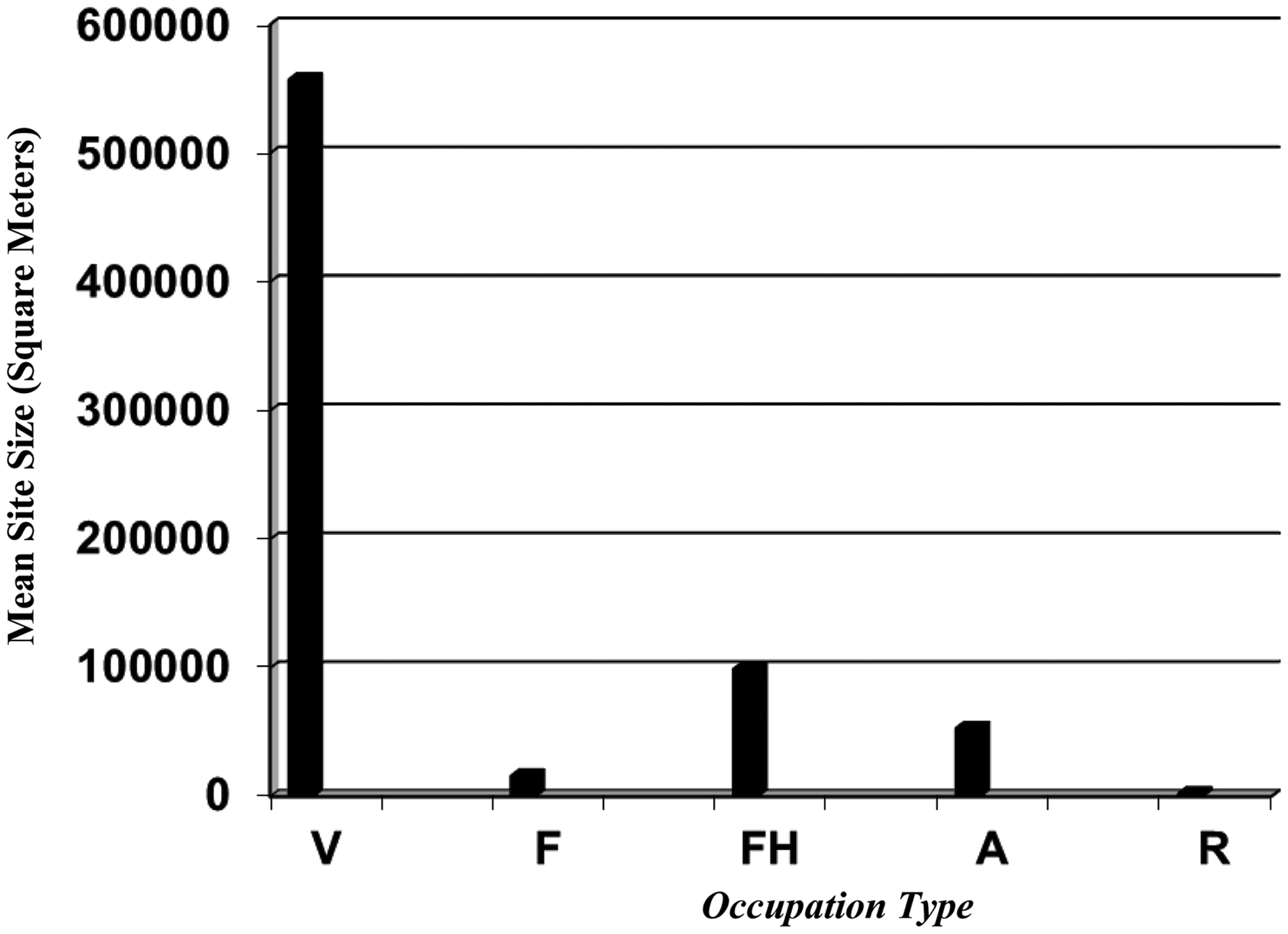
The largest and most complex cultural locus has been designated as Locus A, measuring 125,000 sqm, located across the southwestern, central, and northeastern sectors of the site, adjacent to the southern main channel braid of Cottonwood Canyon Wash. This locus contains 25 prehistoric features and thousands of artifacts. Observed prehistoric features represent ceremonial (ball court), residential (pit houses), domestic (hearth/roasting pits), trash disposal (trash mounds), and water control (berms, reservoir, and canal segments) zones (Table 1).
The dominant feature from this locus is the trash mound, as 13 different artificial mounds have been identified; Feature 1, in particular, was sectioned by construction of Cottonwood Canyon Road, exposing a deposit of cultural material in excess of 1 m thick. Surface observed artifacts from Locus A include pottery, chipped stone, and ground stone. Although mica schist Gila Plain was the dominant pottery style, numerous buffwares, including late pre-Classic Santa Cruz and Sacaton red-on-buff wares were identified from these mound areas. Chipped stone was less common, but tools including cores, hammerstone, and cobble-related tools were identified; ground stone consisted of metates (Pagoulatos, 2014).
Evidence for ceremonial and residential zones from Locus A consists of the presence for four remnant house-in-a-pit structures and a large oval-like depression, measuring 37 m northeast to southwest and 17 m northwest to southeast, and 0.5 m deep; the dimensions of this feature approximate those of a possible ball court. A large domestic-related rock-filled pit containing thermally altered rock and dark gray and ashy fill was also exposed in the road bed; the dark staining around this feature continued at least 3 m into the road and 2 m to the east and 4 m to the west. Numerous water control features were also encountered, including a presumed reservoir, a berm, and a presumed canal segment (Pagoulatos, 2014).
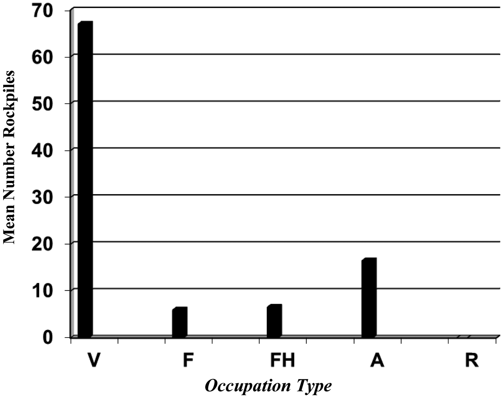
Overall, the AGI is the most diversified of all occupation types, with a measure of 5 (Figure 3), with a wide variety of utilitarian and nonutilitarian (chipped stone, ground stone, ceramics, and worked shell) and nonutilitarian (shell bracelet fragments) items, which are rarely found at other occupation types (Pagoulatos, 2013). The FCI (12) also reflects a wide range of cultural behaviors, indicative of food processing and cooking, residential areas, trash disposal, agricultural, water control, and presumed ceremonial activities (Figure 4). Site AZ U:15:200 contains numerous trash mounds, a berm, hearths, roasting pits, rock rings and horno-like ovens, canal segments and a reservoir, a ball court, pit houses, and numerous rock piles. A total of 67 rock piles were recorded (Figure 5; (Pagoulatos, 2014).
Artifact grouping index and occupation type (V is village, F is farmstead, FH is field house, A is agricultural field site, and R is resource processing site). Feature class index and occupation type (V is village, F is farmstead, FH is field house, A is agricultural field site, and R is resource processing site). Mean number of rockpiles and occupation type (V is village, F is farmstead, FH is field house, A is agricultural field site, and R is resource processing site).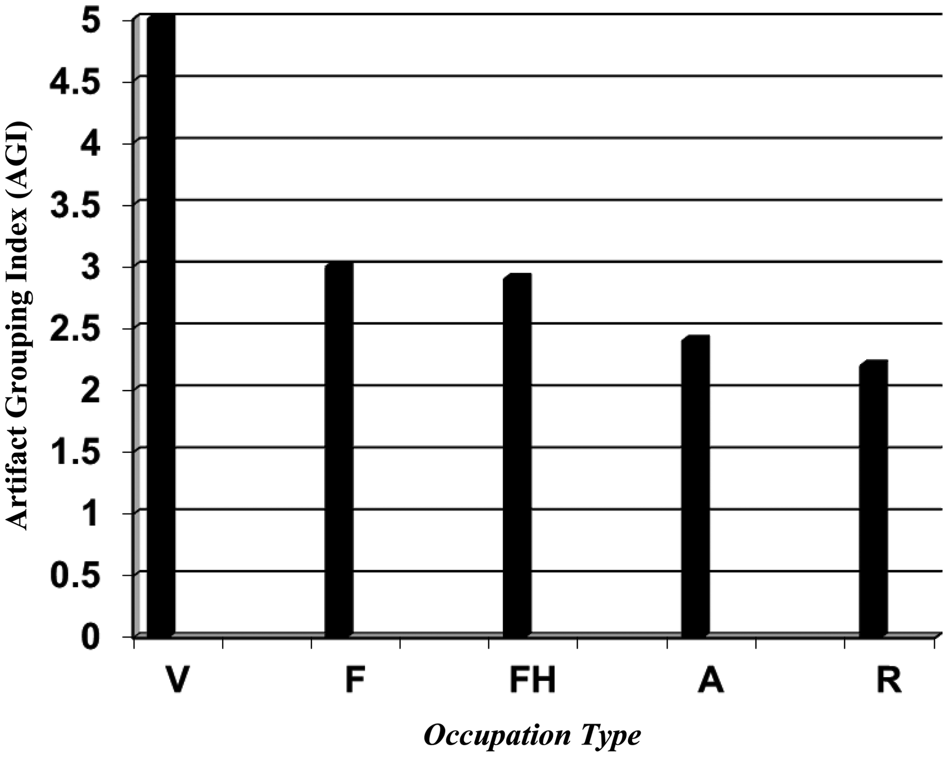
Raw materials (minerals), used for stone artifacts, also show a diverse array of stone usage, with a MCI of 10 (Figure 6). Although a wide variety of stone materials were used to make tools, the vast majority of minerals, such as rhyolite, basalt, chert, vesicular basalts, and chalcedony were locally procured from bajada, terrace, and riverside gravels and cobbles. Small quantities of nonlocal stone such as obsidian were procured from long-distance sources as far as 200 km away (Craig, 2001; Craig and Hackbarth, 1997); marine materials such as Olivella, Glycymeris, and Columbella shell species, used to make ornaments, were derived from the Gulf of California and the California Coast (Craig, 2001).
Mineral class index and occupation type (V is village, F is farmstead, FH is field house, A is agricultural field site, and R is resource processing site).
When examining and subdividing stone artifacts into chipped (lithic) and ground stone tool categories, this site has produced a wide array of tool types. The LCI and GCI produce a measure of 9 (Figure 7) and 5 (Figure 7), respectively. Lithic tools typically consist of large amounts of waste flakes, cores, and shatter, indicative of tool-making activity areas, projectile points, and scrapers, related to hunting, and a variety of bifaces, drills, gravers, denticulates for hideworking, woodworking, and bone working, tabular knives and pulping planes, which may have been used to process plant foods, such as agave and cholla. Ground stone tools consist mostly of pestles, manos, and metates used for agricultural-related activities. Small amounts of worked shell have also been detected, some of which represent ornaments manufacture of bracelets.
Artifacts and occupation type (V is village, FA is farmstead, FH is field house, AG is agricultural field site, and RP is resource processing site).
This site also contains a diverse variety of ceramic wares, with a CCI of 6 (Figure 7). Ceramic remains from this site indicate that a variety of forms, including jars and bowls, and reflect chronologically diagnostic materials, including Gila Plain (red variety), Gila Plain (salt variety), Gila Plain (unspecified), buffware (unspecified), as well as Gila Butte red-on-buff, Sacaton red-on-buff, and Santa Cruz red-on-buff, which specifically date to the Colonial and Sedentary of the late pre-Classic period.
Farmsteads
A total of three sites have been classified as farmsteads, two of which are located on alluvial fans (AZ U:15:195, 205) and one on a ridge top (AZ U:15:700) (Table 1). Farmsteads are much smaller than the village site in areal extent, measuring about 16,157 sqm in size (Figure 2). Farmsteads tend to produce relatively small and more limited artifact assemblages, typically totaling less than 1,000 artifacts (Pagoulatos, 2012b, 2013), with an AGI of 3 (Figure 3). Farmsteads only contain utilitarian artifacts, consisting of lithics, ground stone, and ceramics.
The FCI for this occupation type is 3.3, which is indicative of a more limited range of features, primarily consisting of residential areas, associated with food processing, cooking, trash disposal, and agricultural-related features (Figure 4); the average number of rock piles is six per site (Figure 5). Farmsteads tend to consist of one or two pit houses, rock rings, trash mounds, and rock piles. For example, Site AZ U:15:700 extends across a low plateau, or ridge top, onto a lower lying terrace, overlooking a large wash. An earthen mound has been detected proximate to the wash; this slightly mounded feature measures 12 × 10 m, or 120 sqm in area and appears to represent a pit house. Closely associated are two presumed trash mounds, which measure 4 × 3 m (12 sqm) and 3 × 5 m (15 sqm) in size. Overlooking these residential areas on an adjacent ridge top are five rock piles and a rock ring (Pagoulatos, 2013).
Raw materials used for stone artifacts exhibit a rather low range of stone usage, with a mean MCI of 3.3 (Figure 6). Stone materials exclusively consist of locally derived basalt, vesicular basalt, rhyolites, and chert. Also, lithic and ground stone tool categories reflect a rather narrow range of artifact classes, with the LCI and GCI yielding a mean of 3.3 (Figure 7) and 2 (Figure 7), respectively. Lithic tools typically consist of small amounts of waste flakes, cores, choppers, and hammerstones; ground stone tools usually include manos and metates.
Farmsteads also tend to produce a relatively low variety of utilitarian ceramic wares, with a CCI of 3 (Figure 7). Ceramics from these sites tend to consist of Gila Plain, Santa Cruz, and Sacaton red-on-buff, and buffwares, which are attributed to the Colonial and Sedentary of the late pre-Classic period. More specifically, these farmstead sites typically do not contain a wide range of ceramic types, ranging from a CCI of 2 for AZ U:15:195 and a CCI of 3 and 4 for sites for AZ U:15:700 and 205, respectively. Ceramic data, in conjunction with detected features, appear to indicate that these sites were likely occupied by small family or domestic units, for a rather limited range of time, when compared with the larger habitation sites; these sites do not appear to have been intensively reoccupied.
Field houses
Eleven field houses were encountered, all of which are present on creosote flats; these sites mostly dated to the late pre-Classic, with minor Classic period components (Table 1). Although these sites do not yield direct evidence for residential structures, they do contain a high percentage of ceramic (serving) bowls across distinct activity areas, perhaps implying the presence of ephemeral, or temporary, ramada-like structures (see Swanson et al., 2013).
Field houses possess a wide dispersion of occupation size, ranging from 981 sqm to 454,433 sqm, with a mean size of 99,117 sqm (Figure 2). These sites tend to produce a relatively high diversity of artifacts, usually totaling over 1,000 items, atleast for the larger sites (Pagoulatos, 2013). The AGI measure for these sites exhibits a mean of 2.9 (Figure 3), typically containing lithics, ground stone, and ceramics.
Although field houses have a rather high dispersion of artifact groupings, feature distribution is rather low, with a FCI of 0.6, which is indicative of a more limited range of features, primarily consisting of agricultural-related features such as rock piles and associated activity areas (Figure 4); the average number of rock piles is 6.4 per site (Figure 5). By contrast, raw materials exhibit a rather high range of stone usage, with a mean MCI of 7.6 (Figure 6). Stone materials exclusively consist of locally derived basalt, vesicular basalt, rhyolites, chert, diabase, chalcedony, quartz, and quartzite. Also, lithic and ground stone tool categories reflect a rather high range of artifact classes, with the LCI and GCI yielding a mean of 7.6 (Figure 7) and 1.8 (Figure 7), respectively. Lithic tools typically consist of waste flakes, cores, choppers, utilized flakes, scrapers, tabular knives, pulping planes, and hammerstones; ground stone tools usually include manos and metates. Additionally, a high number of Gila Plain, buffware, Gila Butte, Santa Cruz, and Sacaton red-on-buff serving bowl and storage jar forms have been encountered, with a mean CCI of 4.7 (Figure 7). As a whole, feature data reflect rather specialized dry farming activities, but artifactual material indicates that these locales were intensively reused by task groups or domestic units over the entire span of the late pre-Classic period.
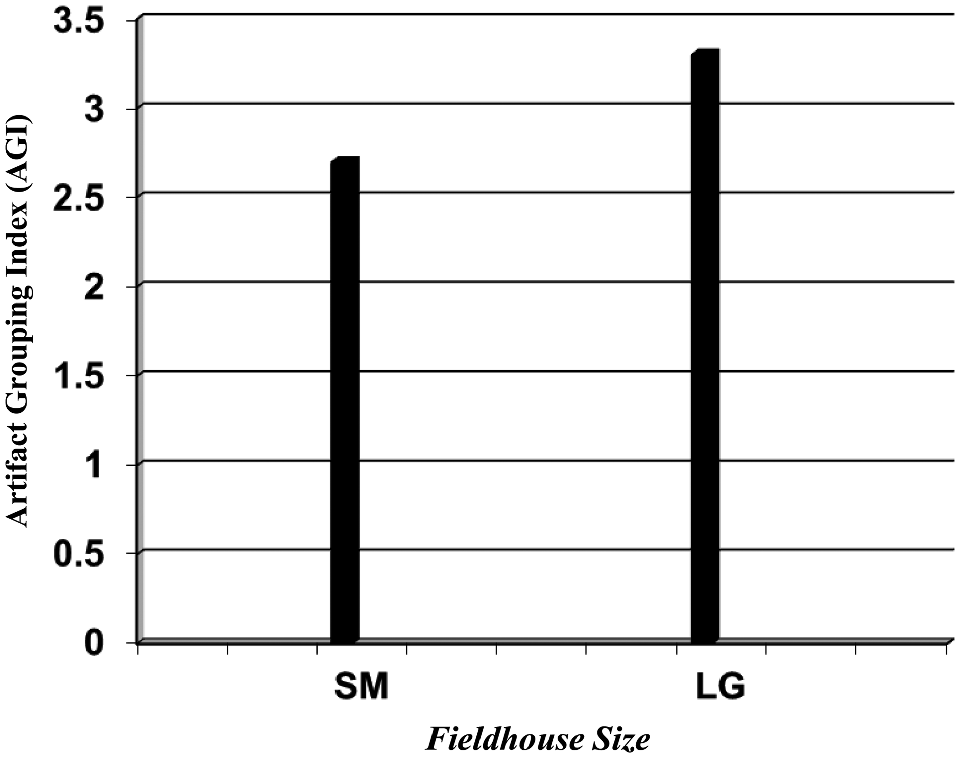
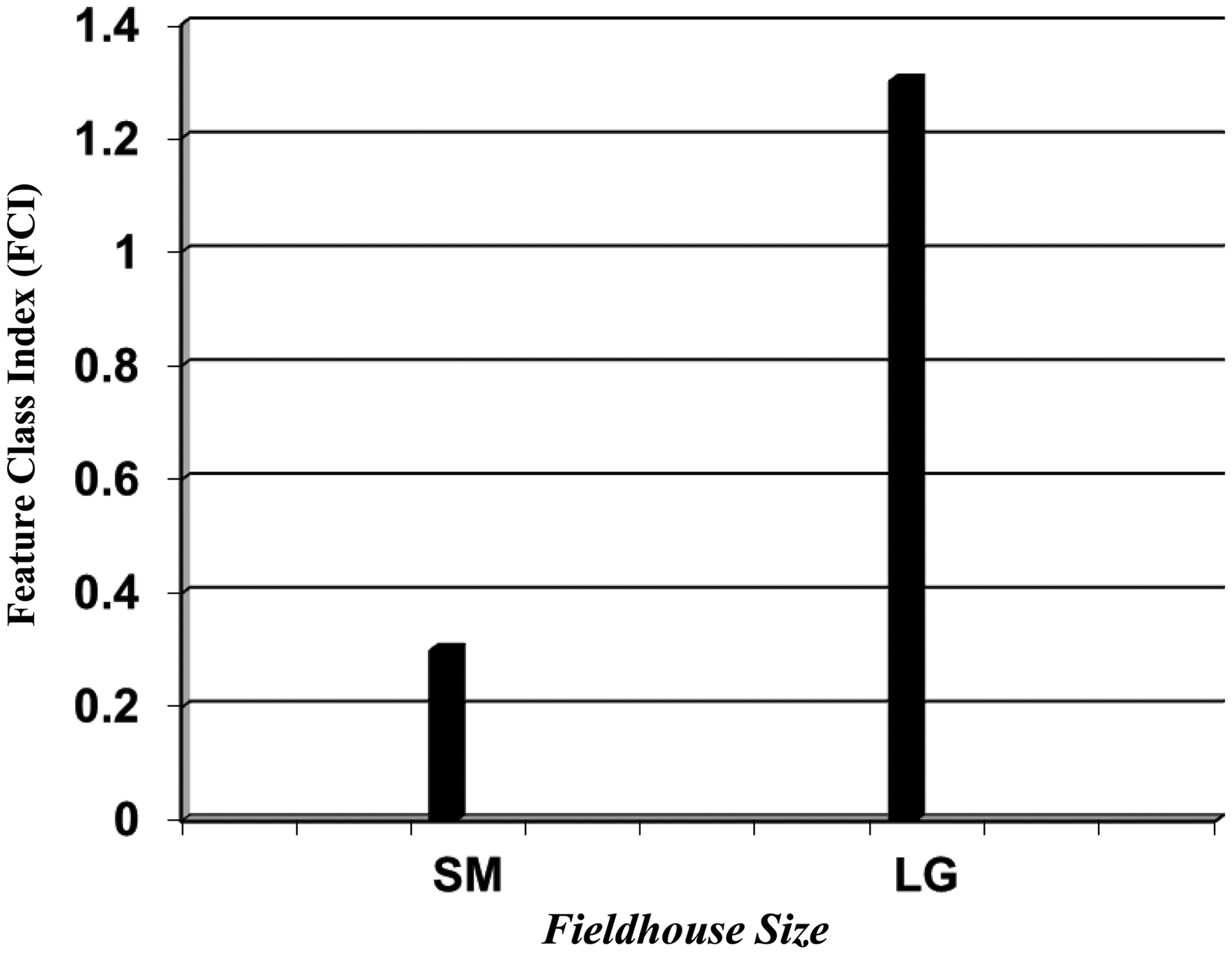
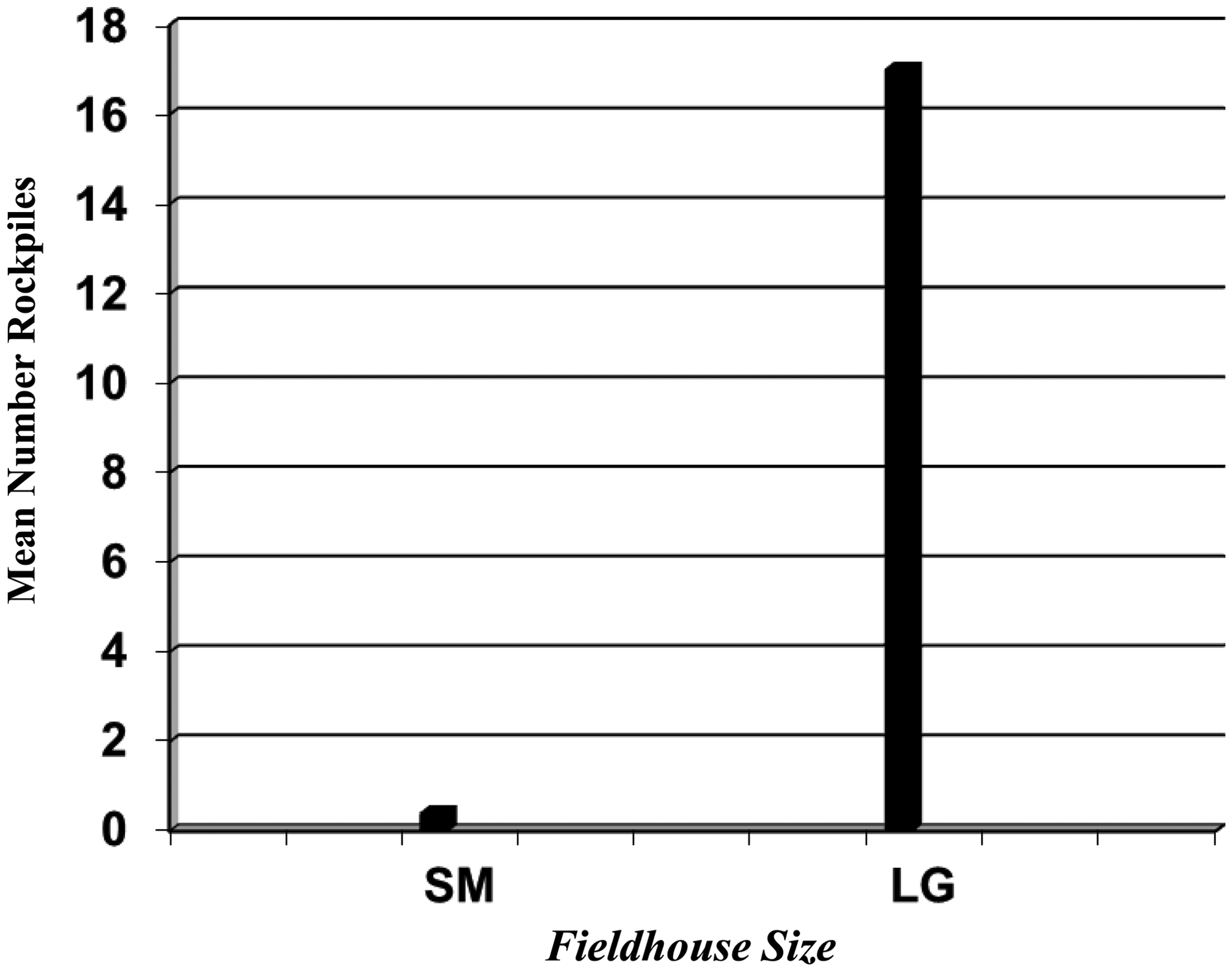
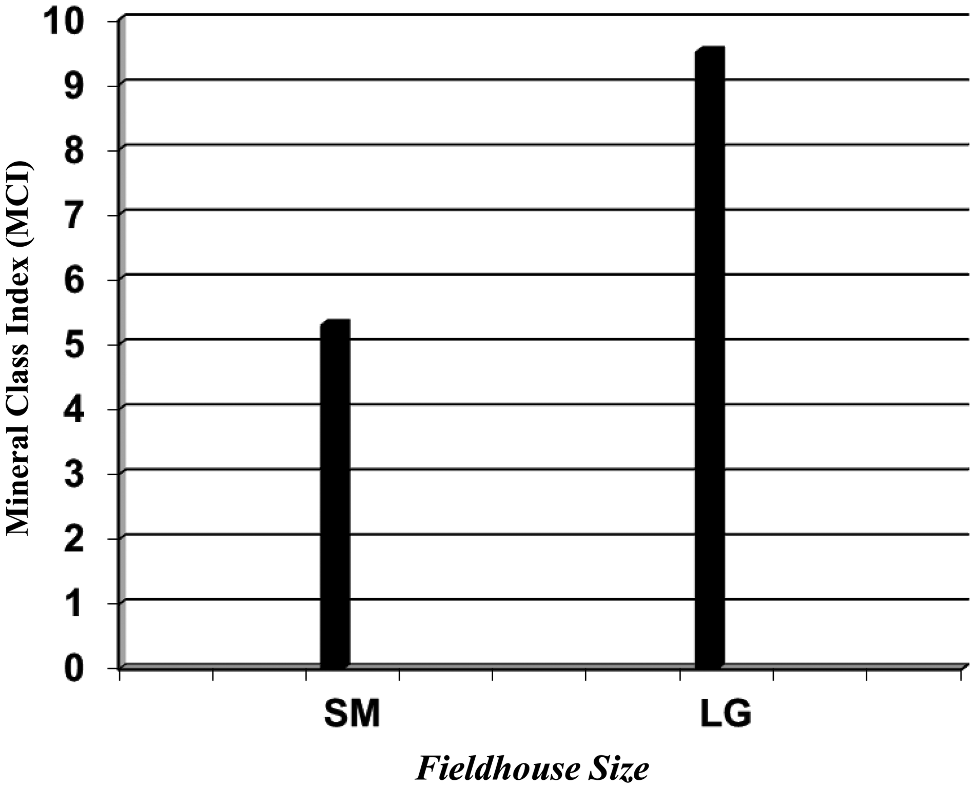
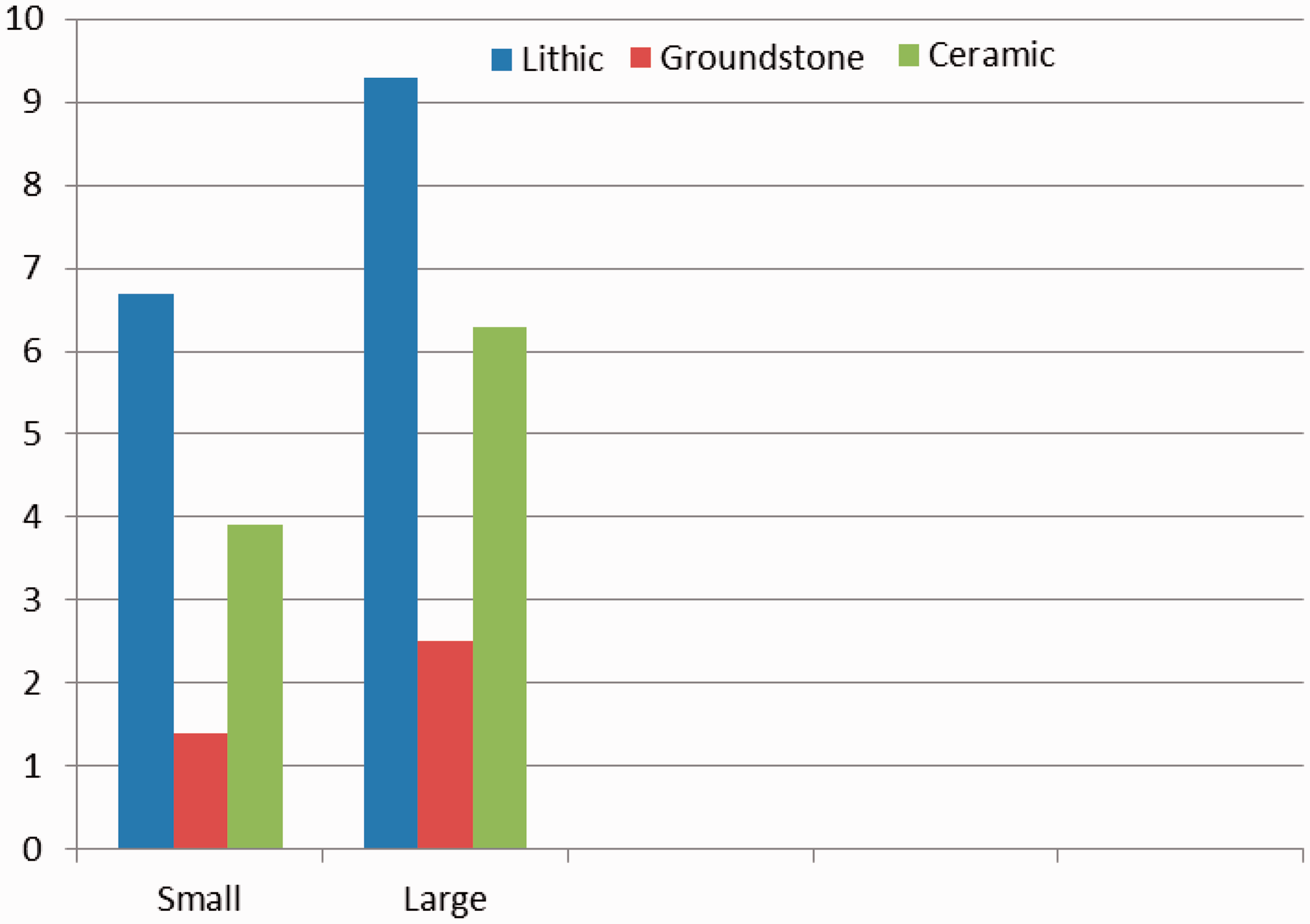
When comparing larger and smaller sized field houses, certain patterns emerge. Small-sized sites such as AZ U:15:785, 796, 802, 804, 805, 808, and 809 yield a mean of 9,995 sqm (Figure 8), with a AGI of 2.7 (Figure 9). Detected features are rare at these sites with a FCI of 0.3 (Figure 10), with an occasional rock pile or activity area; the average number of rock piles is 0.4 per site (Figure 11). These sites also produce relatively lower MCI (5.3; Figure 12), LCI (6.7; Figure 13), GCI (1.4; Figure 13), and CCI (3.9; Figure 13). These sites tend to be temporally assigned to either the Colonial or Sedentary periods. By contrast, larger sized field houses, including AZ U:15:771, 799, 812, and 814 average 255,080 sqm in areal extent (Figure 8), with a AGI of 3.3 (Figure 9). Although these larger sites exhibit higher artifact grouping diversity, they have a very specialized feature dispersion, with a mean FCI of 1.3 (Figure 10), mostly consisting of rock piles and lithic workshop loci, with an average of 17 rock piles per site (Figure 11). Despite a rather low FCI measure, these sites produce relatively higher measures of MCI (9.5; Figure 12), LCI (9.3; Figure 13), GCI (2.5; Figure 13), and CCI (6.3; Figure 13), when compared with smaller sized sites. These larger sized sites tend to span the entire late pre-Classic Colonial and Sedentary periods. These data appear to indicate that smaller sites represent limited use locales used by specialized task groups, or domestic units, while larger sites reflect repeated and multiple uses by domestic units, on a seasonal basis.
Mean site size and field houses (SM is small sized and LG is large sized). Artifact grouping index and field houses (SM is small sized and LG is large sized). Feature class index and field houses (SM is small sized and LG is large sized). Average number of rockpiles and field houses (SM is small-sized and LG is large-sized). Mineral class index and field houses (SM is small sized and LG is large sized). Artifacts and field houses.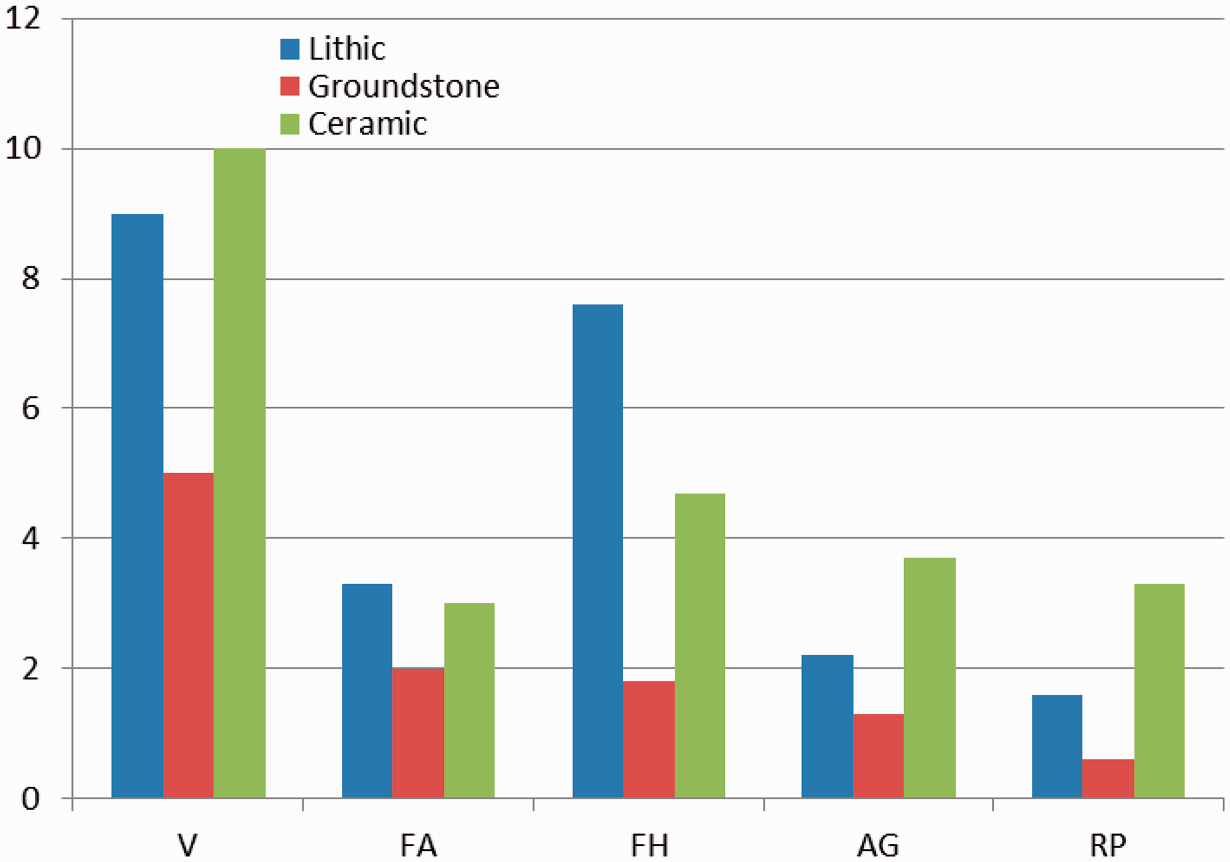
Site AZ U:15:771 is the largest encountered field house, extending across an area measuring 454,433 sqm. A total of 2,903 prehistoric artifacts were encountered during transect survey, although over 20,000 artifacts are projected, based on systematic sampling. The site consists of numerous cultural loci, features, and extensive artifact scatters; a total of 53 rock piles were encountered across the site. Overall, the site assemblage consists of a very wide range of ceramic, lithic, and ground stone tools. Late pre-Classic ceramics include thousands of micaceous-tempered Gila Plain body, rim, bowl, and shoulder sherds, micaceous- and sand-tempered Gila Plain pot drops, red-on-buff body and rim sherds, buffwares body and rim sherds, as well as Gila Butte, Santa Cruz and Sacaton red-on-buff body and bowl, and rims sherds. Lithic artifacts were predominantly manufactured from basalt, rhyolite, chert, diabase, and vesicular basalt, including shatter, waste flakes, utilized flakes, blanks, cores, bifaces, choppers, pulping planes, scrapers, projectile points, tabular knives, and hammerstones. Ground stone tools consisted of metates, manos, and knives (Pagoulatos, 2013).
A total of 15 cultural loci were identified across AZ U:15:771, of which six (loci 24, 27, 30, 33, 38, and 40) may represent presumed field house locales; these loci have a mean size of 1,067 sqm, and upon closer examination, produced cores, choppers, scrapers, tabular knives, manos and metates, and concentrations of rock piles, which co-occur with late pre-Classic red-on-buff bowls (serving) and jars (storage and transport). Of these recovered ceramic forms, 20% represent bowls and 80% that of are jar fragments, indicating that transport, storage, and serving-related activities took place across these cultural loci (Pagoulatos, 2013). Although these surface-inspected loci have not yielded direct evidence for habitation, ephemeral residential structures, resembling ramada-like structures, may have existed across these loci, but they have yet to be identified. Similar feature and artifact assemblages have been recovered from excavated late pre-Classic and Classic sites along Queen Creek, which have produced ramada-like structures (Swanson et al., 2013).
Agricultural field sites
A total of 17 sites are classified as agricultural field sites, of which 9 are found on creosote flats, 6 are situated on ridge tops, and 2 on alluvial fans (Table 1). These sites are generally quite large in extent, averaging approximately 53,010 sqm in size (Figure 2), by usually contain fewer than 1,000 artifacts. The AGI is also relatively more narrow, when compared with habitation loci, with a mean of 2.4, as these sites mostly yield utilitarian lithic, ground stone, and ceramic artifacts (Figure 3). The FCI for this occupation type is 1.5, implying a more limited range of features, primarily consisting of agricultural-related features related to farming and water control (Figure 4); the average number of rock piles is 16.5 per site (Figure 5). Some of these sites yield hundreds of rock piles, as well as the presence of check dams, rock alignments, canal segments, and occasional reservoirs. Although these sites can be quite large, they tend to produce lower and more limited measures of MCI (2.7; Figure 6), LCI (2.2; Figure 7), GCI (1.3; Figure 7), and CCI (3.7; Figure 7). Agricultural field sites primarily contain expedient cores, utilized flakes, and metates for plant-related processing, made from locally derived stone, and jar vessel forms for food and water transport. For example, sites such as AZ U:15:617 and 453 are two of the largest agricultural fields in the bajada region, the former measuring 512,800 sqm and the latter, encompassing nearly one million sqm in areal extent. Site AZ U:15:617 contains 15 rock pile loci, while Site AZ U:15:453 consists of 33 agricultural field loci, totaling nearly 250 rock piles (Pagoulatos, 2012b).
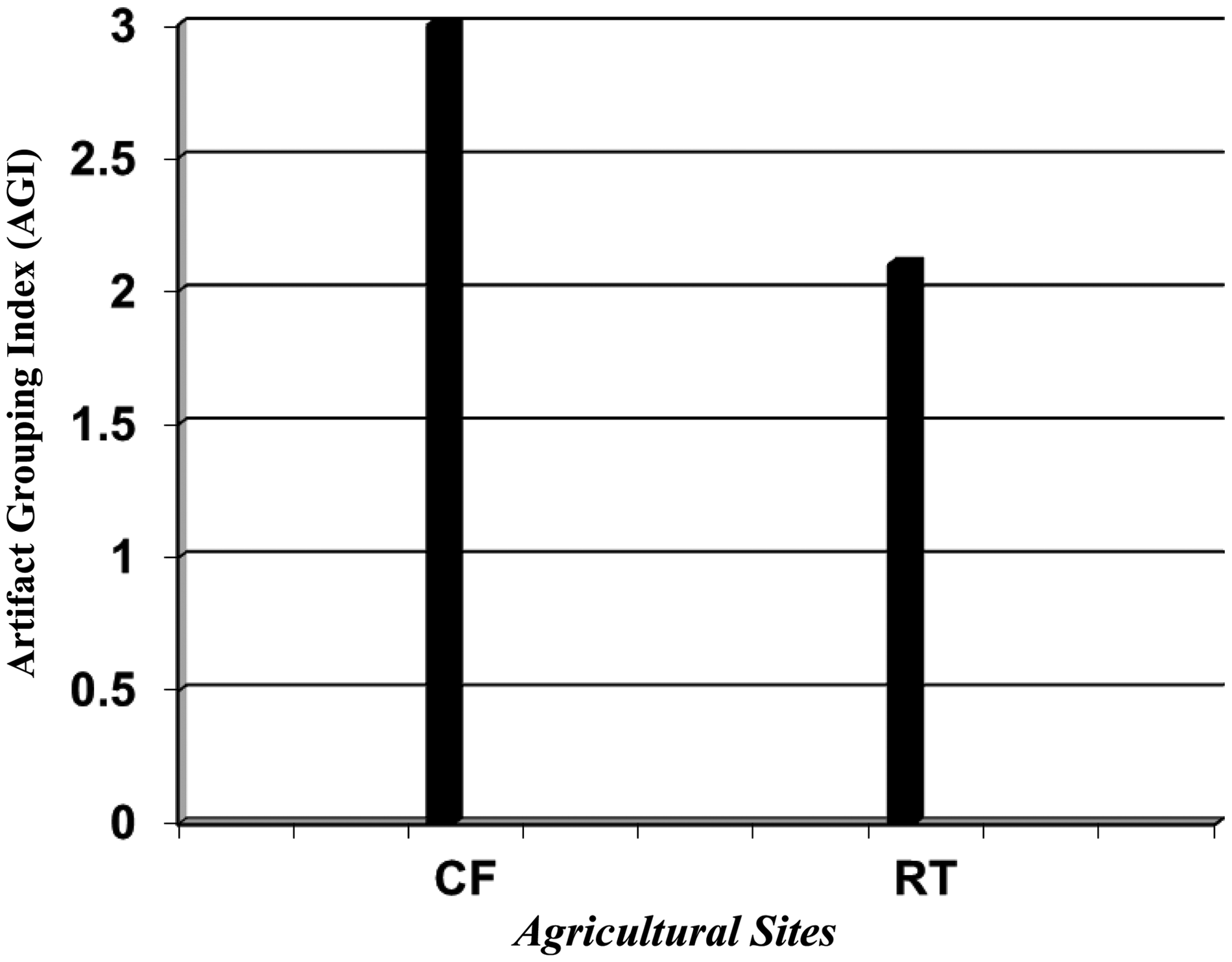
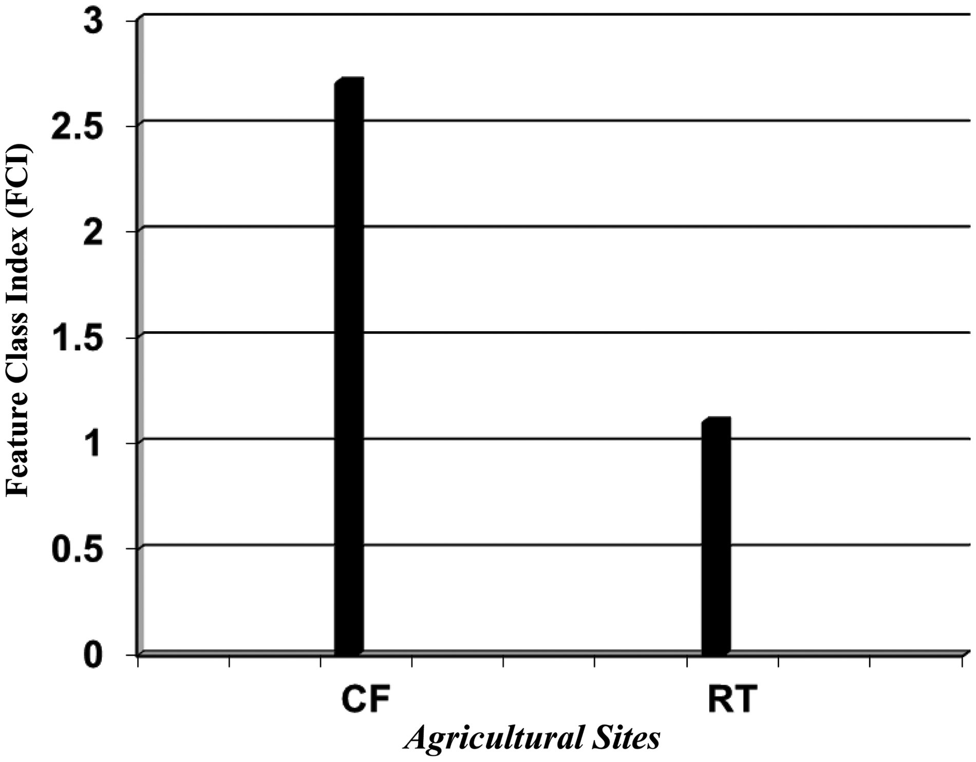
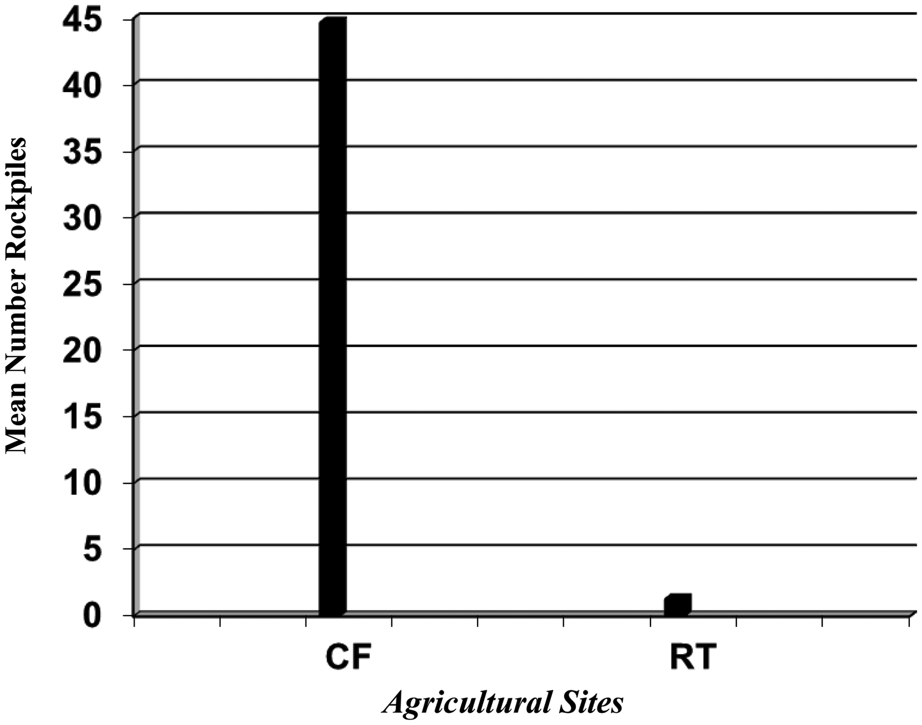
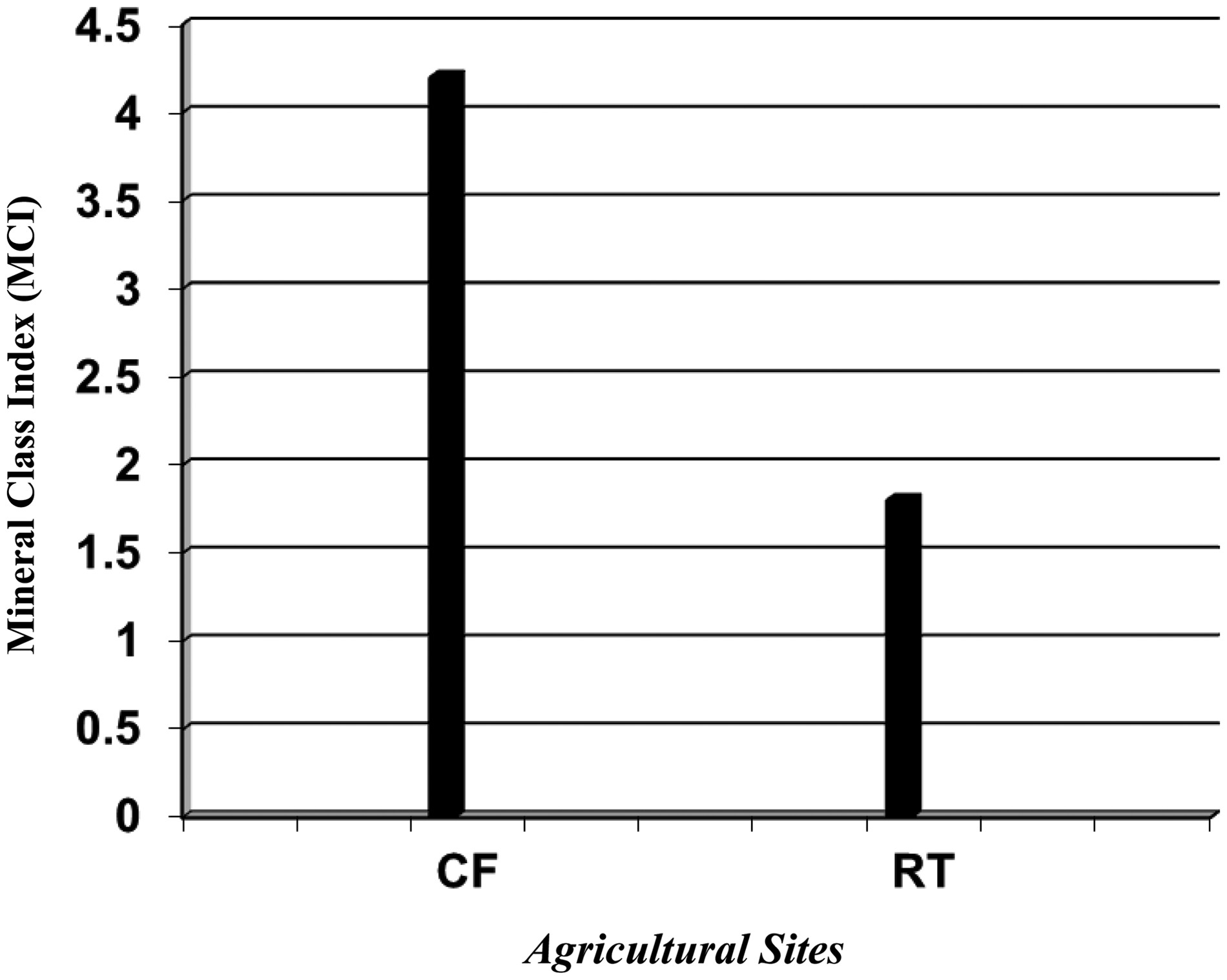
When comparing the nature of agricultural sites on lower lying creosote flats and more elevated ridge top settings, unlike patterns emerge. Sites were compared by size, number of rock piles, stone artifact, and ceramic variability. Lower lying agricultural sites (AZ U:15:439, 440, 443, 453, 617, 810) on creosote flats are considerably larger (131,328 sqm; Figure 14), have a AGI of 3 (Figure 15), and a FCI of 2.7 (Figure 16), with an average of 44.7 rock piles per site (Figure 17). Additionally, the measures of MCI (4.2; Figure 18), LCI (2.7; Figure 19), and GCI (3.2; Figure 19) are relatively higher, when compared with ridge top sites. By contrast, more highly elevated ridge top fields (AZ U:15:185, 186, 189, 192, 197, 691, 713, 734, 748) are much smaller (7,503 sqm; Figure 14), a AGI of 2.1 (Figure 15) and FCI of 1.1 (Figure 16), with only 1.3 rock piles per site (Figure 17). Also, these sites have smaller MCI (1.8; Figure 18), LCI (2; Figure 19), and GCI (0.3; Figure 19) measures.
Mean site size and agricultural sites (CF is creosote flat and RT is ridge top). Artifact grouping index and agricultural sites (CF is creosote flat and RT is ridge top). Feature class index and agricultural sites (CF is creosote flat and RT is ridge top). Average number of rockpiles and agricultural sites (CF is creosote flat and RT is ridge top). Mineral class index and agricultural sites (CF is creosote flat and RT is ridge top). Artifacts and agricultural sites.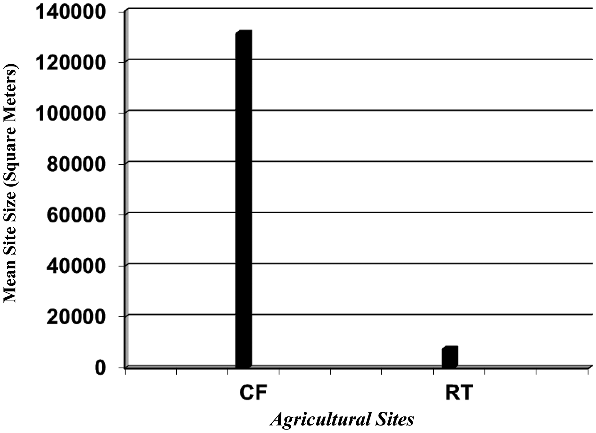
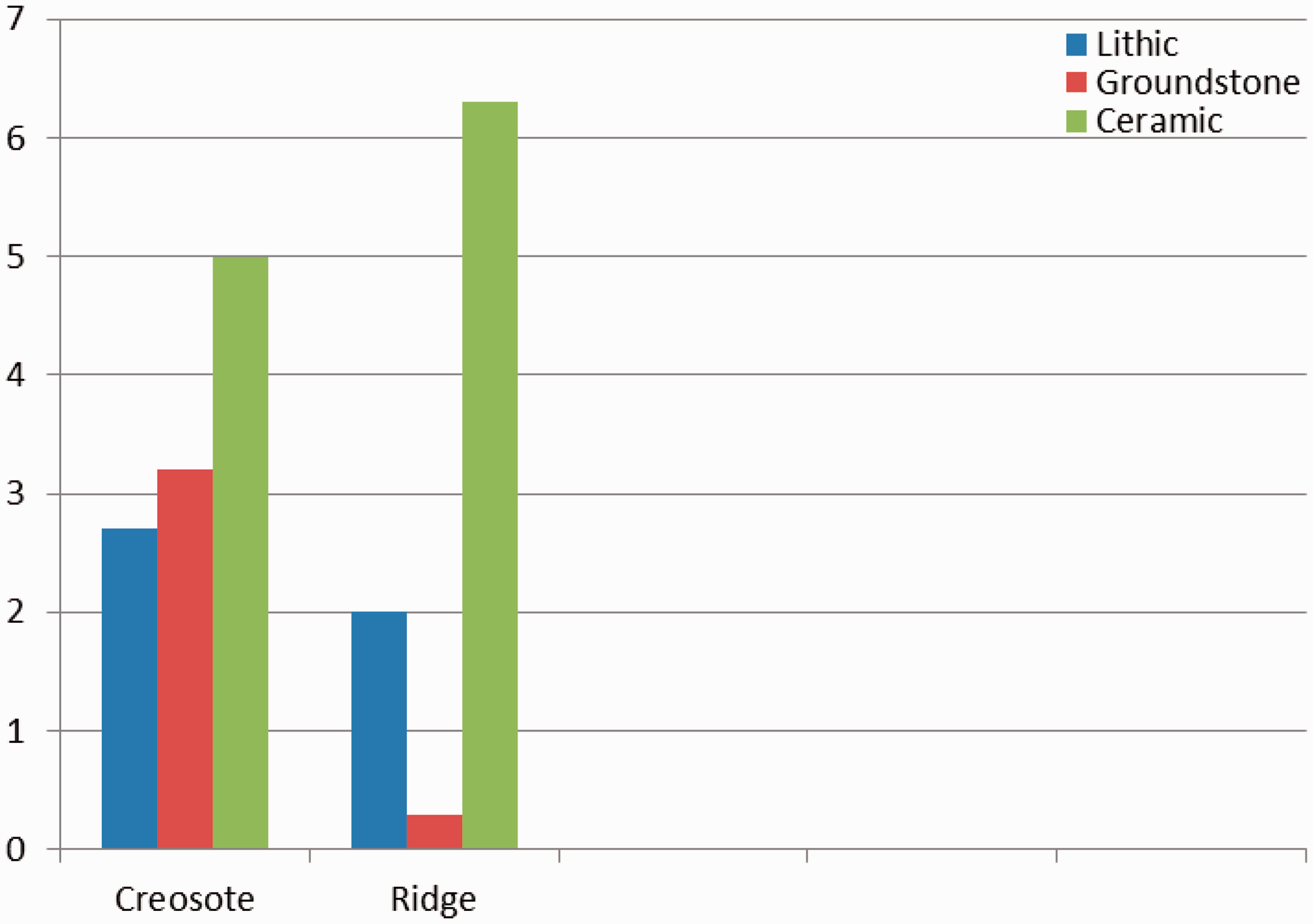
While quantitative measures indicate that a greater number of artifacts and tool diversity are present on the larger agricultural sites on creosote flats, when compared with those on ridge tops, the CCI measure is most informative, with the former having a CCI of 5 (Figure 19), while the latter has a measure of 3 (Figure 19). These data would appear to suggest that although creosote agricultural fields are much larger and yield a wider range of presumed activities; this may be the result of site reuse by small domestic units, or family groups over time, rather than larger social groups during single points in time. By contrast, ridge top sites most likely reflect the movement of small work groups to these zones, as these specific sites may represent more limited and highly seasonal uses of these locales (Pagoulatos, 2013).
Resource processing sites
A total of 18 sites are classified as resource processing sites, of which 7 are found on creosote flats and 11 on ridge tops (Table 1). While these sites are comparatively very small, measuring a mean of 2,355 sqm in size (Figure 2), they do tend to contain hundreds of artifacts. However, the AGI is usually quite limited, with a mean of 2.2 (Figure 3), most often consisting only of lithics and ceramics; ground stone tools are less common. These sites yield extensive activity areas but do not contain any observable features.
Raw materials used for stone artifacts yield a very low range of stone usage, with a MCI of 1.9 (Figure 6). Stone materials almost exclusively consist of locally derived rhyolite, basalt, and chert. Additionally, lithic and ground stone tool categories reflect a very low diversity of artifact classes, with the LCI and GCI yielding a mean of 1.6 (Figure 7) and 0.6 (Figure 7), respectively. Lithic tools most typically consist of cores and waste flakes, while ground stone tools are rare. Resource processing sites also contain a rather low variety of utilitarian ceramic wares, with a CCI of 3.3 (Figure 7). Ceramics from these sites tend to consist of Gila Plain, buffwares, and occasional red-on-buff wares. These sites appear to represent very specialized resource processing sites used by small work groups, away from habitation sites and agricultural fields.
Percentage feature type distribution and occupation types.

Note: AA: Activity area; BC: ball court; C: canal segments; CD: check dams and rock alignments; PH: pit house; RP: rock pile/planter (RP), nd trash mound (TM). Percentage is %. aPresumed ramada-like structures.
Land use models
Using these data, research questions pertaining to settlement patterns, economic orientation, and degrees of residential mobility are addressed below. Previous archaeological investigations of the middle Gila River Valley have focused on riverine environments, where the practice of irrigation agriculture was prominent (Pagoulatos, 2012a). The bajada setting of the project area has presented an opportunity to investigate Hohokam use of nonriverine environments in upland desert areas.
Settlement patterns
Two different settlement pattern models have been presented: zonal and disjunctive. The former is based on the premise that settlement structure was organized in a hierarchical fashion, where administrative centers served to redistribute resources from communities that were distributed in a variety of environmental zones; the latter model argues for bilocational movement of groups to different resource zones, where they intensively extracted resources, on a seasonal basis (Masse, 1991).
If data were to support a zonal model, then there would be evidence for the presence of a large administrative center which would have economically integrated outlying satellite communities in the region. Instead, there is no archaeological evidence for an overriding community, as site distributions represent a series of similar-sized habitation (village) sites located in both riverine and bajada zones. Although village sites contain a similar arrangement of pit houses, trash mounds, ball courts, and activity-related loci, those along the Gila River all yield complex canals systems and broadly resemble irrigation-based communities, while village sites encountered in the bajada zone along Cottonwood Canyon Wash and adjacent areas do not appear to have been integrated into an irrigation-based community. Overall, these two different lowland (Gila riverine) and upland (bajada) regions produce a full range of occupation types and appear to represent distinct and separate territorial units (Pagoulatos, 2012b).
If data were to support the disjunctive model, then data would reflect the bilocational movement of groups to distant and different resource zones, where they would have intensively exploited food items on a seasonal basis (Masse, 1991). Present data yield a rather continuous distribution of site scatters from the floodplain and lower terraces to the bajada, with village clusters detected along the Gila River and bajada, proximate to Cottonwood Canyon Wash. Between these two lowland and upland village clusters, numerous farmsteads, agricultural fields, and specialized resource processing loci have been encountered, perhaps representing places that were shared by different groups associated with their respective riverine and bajada residential zones (see Wells et al., 2004).
Current data support neither the zonal nor the disjunctive model. Instead, a wide range of occupation types were present during the late pre-Classic in the bajada zone: villages, farmsteads, field houses, resource processing, and agricultural field sites. Overall, there appear to be concentration of late pre-Classic sites generally proximate to Cottonwood Canyon Wash. Village sites such as AZ U:15:200 probably served as nodes of late pre-Classic occupation. From this village node, seasonally occupied farmsteads, field houses, agricultural fields, and resource processing loci were established by individual domestic (family) units. This concentration of late pre-Classic sites associated with the village site of AZ U:15:200 appears to represent a full range of occupation types and may reflect a separate and discrete territorial unit (Pagoulatos, 2012b).
Economic orientation
Late pre-Classic groups across the upland desert region of southern Arizona likely practiced a combination of floodwater and dry farming strategies, and to a lesser degree, irrigation technology (Foster et al, 2002; Maase, 1991; Wells, 2003). Based on current archaeological data from bajada-related settings, these unlike subsistence strategies likely resulted in different degrees of economic orientation and cultivation of specific crops such as agave (Fish et al. 1985, 1992; Foster et al. 2002; Wells, 2003), Morman’s tea (Epedra sp.; Purcell et al., 1997), and corn (Crown, 1984).
Current data from FMR appear to reflect a similar and complex array of farming practices, including dry and floodwater farming, and irrigation-based agriculture. Sites along the western portion of the project area (creosote flats) tend to be larger in nature and contain hundreds of rock piles and canal segments, most indicative of dry and floodwater farming, while smaller agricultural fields on ridge tops in the central and eastern portion of the study area predominantly contain only rock pile fields, most resembling dry farming activities (Pagoulatos, 2012b, 2013). To the north, habitation loci have been identified on alluvial fans along Cottonwood Canyon Wash; these sites are associated with canal segments and reservoirs, better indicative of irrigation-like features. Therefore, although the project area was primarily oriented toward dry farming and to a lesser degree floodwater farming, habitation loci to the north of the area did exhibit evidence for irrigation farming (Pagoulatos, 2012b, 2014).
While preserved organic remains were not encountered from this current survey, previous data recovery investigations of Hohokam rock piles, hearths, and slab-lined storage pits in bajada settings immediately to the north of Cottonwood Canyon Wash resulted in the recovery of both macrobotanical and pollen remains, consisting of a wide range of families and genera, including Poaceae, Asteraceae, Cruciferae, Encelia, Solanaceae, Opuntia, Sphaeralcea, Ephedra, Ambrosia, and Cheno-Ams. Interestingly, every investigated rock pile sampled yielded cholla (Opuntia sp.) pollen, perhaps indicating that rock piles in these areas, at least, were built to enhance cholla growth (Milisicek, 1997).
Residential mobility
These differing agricultural practices, or specific types of economic orientation, likely dictated group mobility. As mentioned previously, residential mobility generally falls along a continuum, ranging from highly mobile agriculturalists to relatively sedentary agriculturalists, but most ethnographically documented circum-Sonoran groups were relatively mobile agriculturalists who possessed a rancheria-like settlement pattern and different degrees of agricultural dependence. Groups such as the Tohono O’odham were characterized by biseasonal settlement with highly cyclical movements between summer and winter villages (Hill et al., 2008; Masse, 1991), the Tarahumara, Western Apache, and Upland-Lower Pima are known to have relocated their residences several times per year (Hard and Merrill, 1992; Welch, 1994), while the riverine Pima resided in semipermanent villages (Welch, 1994). While these groups may have possessed varying degrees of agricultural dependence, they all still tended to practice a wide array of agricultural techniques, including floodwater farming, dry farming, and irrigation (Welch, 1994).
None of these models of residential mobility fit the currently available data from the project area. Instead, late pre-Classic data better support a complex system of residential mobility dependent upon landform, seasonality, and ceremonial behavior. Alluvial fans have yielded villages and farmsteads, and were very likely a focus of habitation, at least on a recurring and repeated seasonal basis; this pattern of periodic aggregation could have also been tied into ritual cycles of ceremonial exchange focused around ball courts (Pagoulatos, 2012b). From this habitation zone, task groups and family units likely dispersed to outlying field houses, agricultural fields, and specialized resource site loci on lower lying creosote flats and more elevated ridge tops, from where they processed agricultural foodstuffs and wild foods, prior to their transport of resources back to their village sites.
Conclusions
The primary purpose of this article was to evaluate the nature of late pre-Classic land use in the upland desert or bajada zone at FMR in the middle Gila Valley of southern Arizona. Current data indicate that upland groups practiced a wide range of farming strategies, including floodwater (ak chin), dry farming, and perhaps even limited irrigation-based technology along Cottonwood Canyon Wash. Late pre-Classic groups exhibited a complex residential mobility pattern, where primary habitations such as rancheria-like villages and small farmsteads were situated along alluvial fans of Cottonwood Canyon Wash. This habitation zone has produced a diversity of floodwater, dry, and irrigation-based farming practices associated with residential areas, trash mounds, and a ball court; the combination of farming technology and presumed ceremonial features may have contributed to group aggregation along Cottonwood Canyon Wash, at least on a seasonal basis (Pagoulatos, 2014). From this habitation zone, specialized task groups and domestic units repeatedly used field houses and large agricultural fields out on creosote flats, and smaller dry farming loci, on more elevated ridge tops. From these locales, groups processed foodstuffs, prior to their transport back to the habitation zone along Cottonwood Canyon Wash.
Although this study has attempted to describe and explain the nature of late pre-Classic upland-based land use specific to the FMR area of the middle Gila, regional studies elsewhere in southern Arizona, however, appear to indicate that diverse and very different adaptations may have existed at this time. For example, the Salt River region, about 40 km to the northwest of FMR, contains farming villages with evidence for floodplain agriculture irrigation, while smaller and specialized settlements have been identified in the Papagueria region well over 100 km to the west which broadly correspond to highly mobile groups, with rancheria-style, dispersed villages, lacking ball courts (Bayman, 2001). Data from the greater Gila River Valley indicate that Snaketown (Haury, 1976), about 40 km to the west, represents the largest and most complex pre-Classic habitation site in the region, as inhabitants of this site were highly dependent upon floodplain agriculture irrigation; by contrast, more highly elevated nearby baja zones, overlooking Snaketown, contained villages that concentrated upon dry farming activities (Foster et al., 1995, 2002; Wells, 2003; Wells et al., 2004).
Poston Butte Ruin, located about 10 km to the south, has produced small-scale irrigation canal systems along the middle Gila (Woodson, 2010). The Gila Butte Reservoir region, about 18 km to the east, has produced a variety of habitation and agricultural field sites without evidence for irrigation networks; this portion of the Gila River was not amenable to canal irrigation farming (Debowski et al., 1976). Large rock-bordered gardens, indicative of complex dry farming have been encountered in the Safford Basin, about 100 km to the east (Neely and Doolittle, 2006). Settlement data from both the Casa Grande region, about 15 km to the south-southwest(Crown, 1987), and the Marana Community, about 60 km to the south (Fish et al., 1992), reflect possible administrative polities associated with complex site hierarchies, centered around economic redistribution of a variety of foodstuffs. The former appears to represent a series of linear-based site distributions representing an irrigation community along the Salt River; the latter, an economic redistribution center between a series of interdependent riverine and upland resource zones, linking outlying satellite communities (Fish et al., 1992). Upland settlements of the Santa Rita Mountains, about 100 km to the south, represent less complex floodwater and dry farming strategies (Huckell, 1980).
Thus, this present study indicates that specific economic adaptations were adopted by prehistoric populations in the middle Gila and surrounding areas and that no single model adequately explains the nature of late pre-Classic Hohokam land use across southern Arizona. Instead, each region must be evaluated in terms of specific criteria and parameters, as related to landforms, agricultural practices, settlement-subsistence behavior, mobility patterns, regional integration, and emerging territoriality.
Footnotes
Acknowledgments
The author would especially like to thank Anthony Boldurian and one anonymous peer reviewer for reviewing an earlier draft of this article. I would also like to thank Steve Swanson, Rick Karl, David Abbott, Sylvia Kadlubowski, and Ken Fiebelhorn for their assistance. Of course, any inaccuracies in this article are the sole responsibility of the author.
Declaration of Conflicting Interests
The author(s) declared no potential conflicts of interest with respect to the research, authorship, and/or publication of this article.
Funding
This research received no specific grant from any funding agency in the public, commercial, or not-for-profit sectors.