Abstract
This article is about a period of technology transfer – the late 1910s and 1920s – when wartime aerial reconnaissance techniques and operations were being adapted to a range of civilian uses, including urban planning, land use analysis, traffic control, tax equalization, and even archaeology. At the center of the discussion is the ‘photomosaic’: a patchwork of overlapping aerial photographs that have been rectified and fit together so as to form a continuous survey of a territory. Initially developed during the First World War to provide coverage of fronts, photomosaic mapping was widely practiced and celebrated during the postwar years as an aid to urban development. The article traces both the refinements in photomosaic technology after the Armistice and the rhetorical means by which the form’s avant-garde wartime reputation was domesticated into an ‘applied realism’ that often effaced its site-specific perspective, its elaborately rectified optics, and the oppositionality of both its military and civilian uses. The article has a broader theoretical aim as well. Classic statements of both structuralist and post-structuralist spatial theory (Barthes and de Certeau are the primary examples here) have produced an ossified geometry wherein the vertical is the axis of paradigm, top-down strategy, and manipulative distance and the horizontal the axis of syntagm, grassroots tactics, and resistant proximities and differences. In its close study of the technology and rhetoric surrounding interwar photogrammetry, the article provides an example of how one might reverse the long-standing misrecognition of high-altitude optics as effacing time, difference, and materiality – and what it might mean to view such optics as, instead, a resource in turning from abstract toward differential conceptions of both aerial photography and our theoretical habits. This turn I call ‘applied modernism’, a term that accesses both the wartime photomosaic’s affiliation with avant-garde painting and its insistence that portraits of the total are always projections from partial, specific vantages.
So much information that would otherwise have been concealed from the enemy was revealed by the all-seeing lens. … No matter how carefully machine-gun emplacements may have been concealed, their position was often betrayed by the disclosure of foot tracks made over-night to and from munition dumps. Dummy trenches and other appurtenances of warfare were detected easily enough, for the absence of shadow on the completed prints was sufficient to rouse and to justify suspicion. … [the enemy’s] possible future activities (as well as past and present) [were] laid before [the Allies] like an open book. (Winchester and Wills, 1928, on First World War aerial reconnaissance)
Mrs. Smith’s washing can be seen hanging on the line, so you know Mrs. Smith’s wash day even if you don’t know Mrs. Smith. (Fairchild, 1922, on peacetime photogrammetry)
IN HIS memoir, Overview: A Lifelong Adventure in Aerial Photography (1969), retired Brigadier General George W. Goddard casts his mind back 40 years to recall a good-natured dispute with then Major General Douglas MacArthur about representation. It’s 1928; Goddard is a First Lieutenant commanding the Air Corps’ 6th Photo Section, 4th Composite Group in the Philippines. Having dropped by on an impromptu inspection, MacArthur is being shown an aerial photomosaic, which Goddard describes as a map of the Bataan Peninsula. The General, outfitted as usual – ‘cream-colored britches, Sam Browne belt, high boots and spurs, and carrying a riding crop’ – peers skeptically at the array of overlapping aerial photos fitted painstakingly together into a composite image. ‘Young man’, he declares, ‘that is not a map, only the Corps of Engineers makes maps.’ ‘According to Webster’s Dictionary, sir’, Goddard brightly retorts, ‘a map is a representation of the surface of the earth, and here is one without any human errors.’ MacArthur chuckles, but later, on his way out, he takes care to have the last word: ‘You understand, young man, that’s not a map … yet!’ (1969: 201–2). Their exchange limns the problem-space of this article. A conversation in which targeting and cartography are deeply entangled turns on the question of whether representation is degraded or produced by human error. For Goddard, a pioneer of aerial reconnaissance and photogrammetry since the late 1910s, the aerial photo’s mechanical origins, indexicality, and detail-saturation free itfrom such error, making it all the more a ‘representation of the surface of the earth’ – all the more quintessentially a map. 1 But where for Goddard error mars mimesis, for MacArthur the unerring aspect of the aerial photograph disqualifies it as a map, a medium whose essence and utility depend on its errors: its subtractive logic, its wandering away from saturation toward selectivity and interpretation, even its encoding of mistakes that signify. The aerial photo, by MacArthur’s lights, is too full of information to be legible or navigable; it too nakedly presents without representing.
Even in declaring the photomosaic a non-map, the MacArthur of Goddard’s recollection accepts at least one of the younger man’s premises about aerial photography: that it miniaturizes the territory without loss of resolution or proportion, capturing without error. Similar claims had been made about aerial photographic reconnaissance since the First World War, when the technique’s first advocates touted its precision in revealing enemy trench locations and troop movements, its power to see through the ruses of camouflage and guide artillery targeting, and its production of peerlessly accurate historical documents. Yet even those early partisans of the ‘all-seeing lens’ and its capacity to open the book of enemy tactics recognized that the accuracy of aerial photographs was a latent property that could be activated only when the medium’s native disfigurements were undone. Here are Winchester and Wills again, tempering their claims about the raw legibility of vertical images:
The untrained mind can divine more information from a vertical photograph than the trained mind can from an ordinary topographic map, although we cannot claim for the aerial view extreme accuracy until it has been corrected for distortion caused by tilt, and adjusted to a system of controls supplied by a ground surveyor. It is possible that the time may come when for cadastral and ordnance purposes the aerial photographic survey will be accepted as a map after the customary references already provided by drawn maps have been added. (Winchester and Wills, 1928: 13)
These finicky parameters were further narrowed in the case of images composed of many individual stills, each of which had to be rectified andthen harmonized with its neighbors. The resulting photomosaics (see Figure 1) were not so much taken as produced, often by workers trained in the highly technical business of compensating for tilt, blur, vibration, and paper shrinkage and expansion, as well as in minimizing the scalar and temporal incompatibilities of their constituent images. To observe this is not to impugn the accuracy of these images, exactly. But it is to find in them a particular, contingent, perhaps deceptive, kind of accuracy, one that invited the viewer to misrecognize as an integrated, synchronic image what was in fact a diachronic series of images patchworked and blended together; to accept as unerring an image whose erroneous components had been squared, as nearly as possible, through compensatory fixes. Whether or not the photomosaic was a map, it was anything but free from human error. It was, rather, a delicate pas de deux of error and counter-error.
Photomosaic made in 1920 of land along the Anacostia River east of Washington, DC. To illustrate the method of photomosaic composition, the edges of the composite image have been left untrimmed and the variation in the constituent images’ exposure uncorrected. Source: Lee (1922: 22a)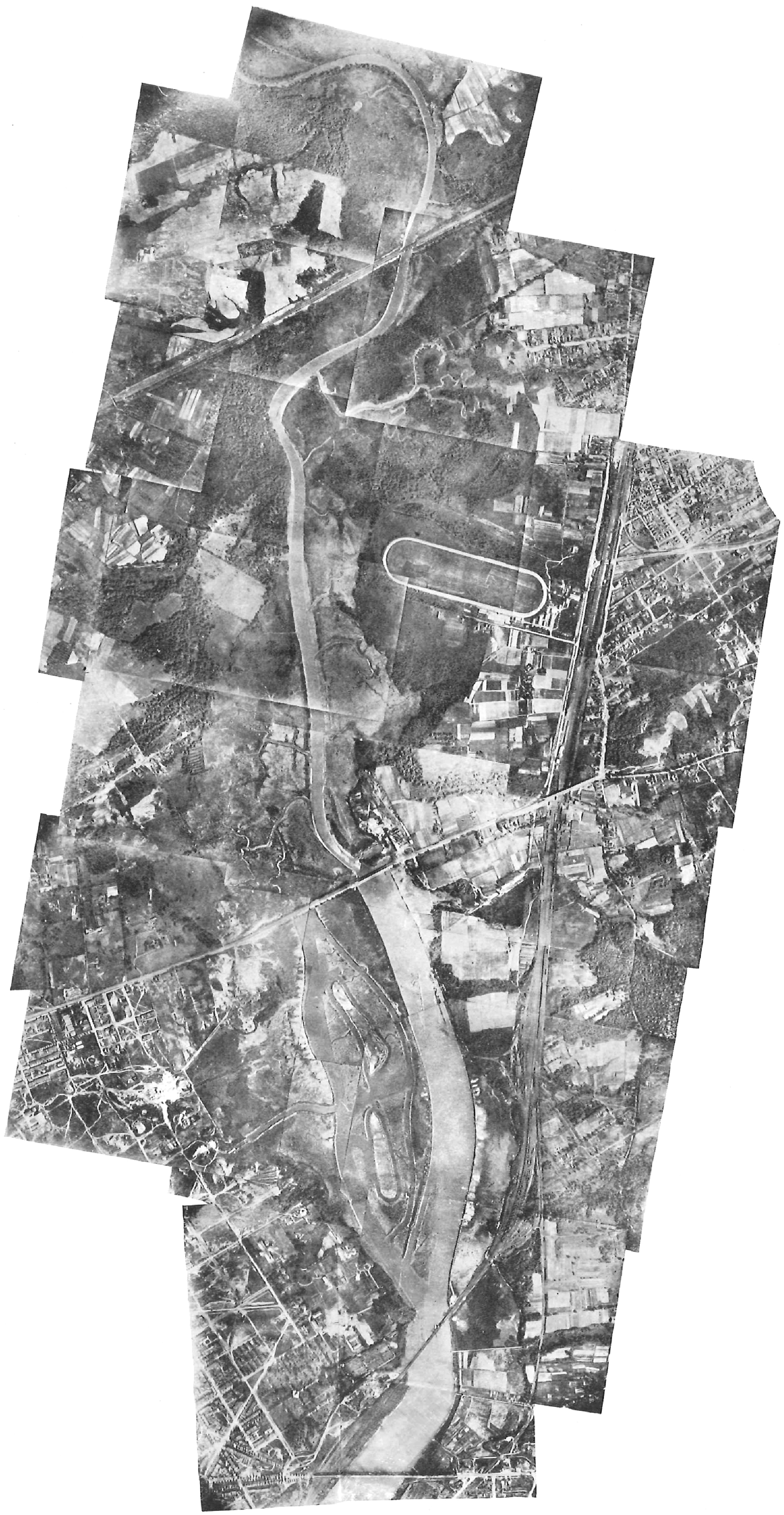
This article is about a period of technology transfer when wartime reconnaissance techniques and operations were being adapted to a range of civilian uses, including urban planning, land use analysis, traffic control, tax equalization, and even archaeology. 2 Entailed in this transfer are a series of questions about what happens when technologies developed by a state for use against a wartime adversary are adapted for peacetime use by that same state in relation to its own citizens, territory, and municipal infrastructures. In what ways does such a technology residually construct its domestic objects as distanced, derealized, and oppositional – that is, as targets in the military sense? What do the civilian uses of the term target retain of their military origin? What complexities might we lose by reducing our origin-narratives about particular technologies to strictly military or civilian geneses? In respect to aerial imaging, our thinking about such questions in recent decades has tended to proceed from certain articles of faith. The plan view, we like to say, totalizes by sheering off singularity, complexity, anomaly, and dissent in favor of schematic simplicity. Relatedly, distance – especially the growing spatial, optical, and technological distance between perceiver and seen – instrumentalizes and in some cases dehumanizes the seen in profoundly consequential ways. Finally, the growth of this distance has happened alongside an acceleration in perception, transmission, and feedback, to the point where what military planners now call the ‘kill-chain’ – the time elapsed between identifying a target and destroying it – is being massively compressed. This article attempts to identify some of the seams between these articles of faith as well as instabilities within each of them. Without denying that aerial imaging can both totalize and instrumentalize what it sees, it suggests that these operations have recoverable limits and, furthermore, that they sometimes require the very exceptions – the partial, the belated, the disjunctive, the differential, the site-specific, the erroneous – whose absence appears to be their defining characteristic. As a paragon of perfect visibility, I will suggest, aerial imaging depends on certain derangements of vision that it hides in plain view.
I have made a related argument about the use of the stereoscope in aerial reconnaissance interpretation from the First World War on (Saint-Amour, 2003). By pairing vertical images taken hundreds or even thousands of feet apart, this technique vastly expands the virtual interocular base of the viewer, producing exaggerated 3-D effects that are interpretively useful in proportion as they expose the spatial contingency of human depth perception. This aerial hyperstereoscopy imparts a fantasy of all-powerful vision by insisting that we always see from somewhere – or, more accurately, from two adjacent but distinct somewheres. And because it asks the viewer to synchronically fuse two images taken in rapid diachronic sequence, the technique insists, albeit more subtly, that seeing is an event rather than a condition; that we always see from some when. In turning here to consider the First World War’s other major reconnaissance legacy – the aerial photomosaic – I will be discussing a form that works harder to efface its multiplicities of viewpoint even as its diachronicity becomes more difficult to conceal. For to look at a photomosaic is to be pulled in two directions: on the one hand, toward accepting the fiction that its constitutive images synch up in an integrated spatial geometry; and on the other, toward awareness of the fact that they were captured at discrete, often distant, moments. When the illusion of spatial integration fails, it does so principally because the composite image separates into tiles of nonsynchronous time. In contrast to the vertiginous spatial depth-effects of hyperstereoscopy, the photomosaic offers the distinct vertigo of temporal parallax, one arising from the experience of counterfeiting a spatially self-identical landscape from a constellation of segregated moments. A photomosaic is perforce a mosaic of temporalities.
My article has a broader theoretical aim as well. In calling attention to the planimetric view’s construction from a diachronic series of images and moments, I underscore the extent to which our still-dominant notions about vertical imaging are themselves based on a misrecognition. These notions were endorsed, as we have already seen, by the practitioners of early aerial photography. But they were given theoretical heft by structuralism’s fixation on a biaxial model of optical space, a model that post-structuralism attempted to dismantle but more effectively perpetuated. According to this biaxial scheme, the vertical is the axis of order, paradigm, symbolic function, disutility, unimpeded sightlines, and disembodied omniscience; whereas to the horizontal belong disorder, syntagm, enunciative function, utility, partial sightlines, and exposure to visibility. In Roland Barthes’ ‘The Eiffel Tower’, for instance, the vertical stands outside of the city’s history and structure, yet by dint of that exemption gives spectators a privileged view of both: as the vantage most conducive to ‘intellection’, the Tower’s verticality ‘permits us to transcend sensation and to see things in their structure’, granting us access, in a single glance, to the city’s blueprint or x-ray and to something like its deep time (1979: 9). Michel de Certeau’s ‘Walking in the City’ transposed Barthes’ parable to New York, with the view from the top of the World Trade Center epitomizing the ‘pleasure of “seeing the whole,” of looking down on, totalizing the most immoderate of human texts’. As against the labyrinth-dwellers at street-level, the Icarus on the 110th floor accedes to ‘a scopic and gnostic drive … to this lust to be a viewpoint and nothing more’ (1984: 92). For de Certeau, the ground-dweller is not only a sign exposed to the city planner’s panoptic reading and schematizing; she may also elude that scopic discipline through the practice of resistant pedestrian speech acts, walking and using the urban grid against the grain of its planners’ intentions. Yet despite celebrating the flâneur’s jamming of the planeur, de Certeau’s essay concretized Barthes’ biaxial mapping: the vertical remains the viewpoint of power’s monopoly on paradigm, even if that power is occasionally stymied, and the horizontal remains the axis of the masses trapped in syntagm, even if they have recourse to resistant enunciative tactics.
Of course, these influential essays are both more complex than my accounts of them. Barthes descants on the ‘dialectical nature of all panoramic vision’, whose frictionless movement across an exposed landscape nonetheless requires the viewer to struggle to decipher it by locating familiar ‘signs within it’ from history, myth, and lived experience on the ground (1979: 10). De Certeau makes the claim, although without dilating on it, that the haunting of places by memory ‘inverts the schema of the Panopticon’ (1984: 108). But like so many cognate discussions of power and visuality, both essays’ schemata have had more longevity than the exceptions, elaborations, and argumentative eddies that complicate them, as the trellis outlives the bougainvillea it was built to support. One result, ironically, has been that essays interested in developing a model of differential space have been annexed to the abstract space of highly schematic thinking. Here I use Henri Lefebvre’s terms deliberately, as a reminder that the native abstraction of ‘theory’ makes it even more susceptible than its objects to homogenization – to the dampening of internal differences, the smoothing of anomalies, the honing off of resistant historicity. For Lefebvre, these differences within the space of both theory and social practice are nothing less than the sites of potential social transformation:
From a less pessimistic standpoint, it can be shown that abstract space harbours specific contradictions. Such spatial contradictions derive in part from the old contradictions thrown up by historical time. These have undergone modifications, however: some are aggravated, others blunted. Amongst them, too, completely fresh contradictions have come into being which are liable eventually to precipitate the downfall of abstract space. The reproduction of the social relations of production within this space inevitably obeys two tendencies: the dissolution of old relations on the one hand and the generation of new relations on the other. Thus, despite – or rather because of – its negativity, abstract space carries within itself the seeds of a new kind of space. I shall call that new space ‘differential space’, because, inasmuch as abstract space tends towards homogeneity, towards the elimination of existing differences or peculiarities, a new space cannot be born (produced) unless it accentuates differences. It will also restore unity to what abstract space breaks up – to the functions, elements and moments of social practice. It will put an end to those localizations which shatter the integrity of the individual body, the social body, the corpus of human needs, and the corpus of knowledge. (1991: 52)
None of which should be read as an injunction to renounce high-altitude, comprehensive, integrative modes of seeing or thinking altogether. Note that, for Lefebvre, it is abstract space’s tendency to localize rather than totalize that shatters individual, social, and epistemological bodies. Homogenization, that is, can be a function of the local – both when it abstracts the local from thelarger bodies on which it depends and when it extrapolates a false image of the whole from a part. To be immanently critical of the totalizing energies within a scopic regime or a system of thought is emphatically not the same thing as giving up on the question of totalities, which is to say, on the question of how ideological effects are produced through the effacement of connections between the distant and the proximate. Far from jettisoning total viewing in favor of partial, the kind of immanent critique I have in mind seeks a dynamic, interrogative relation between the two, recognizing that the total may be, in one instance, a special case of the partial or, in another, the category through whose occultation the partial produces the myth of its autonomy, normativity, or sovereignty.
In what follows, this immanent critique goes by the name of ‘applied modernism’. I use the expression for two reasons. First, as I describe here and elsewhere, early aerial photomosaics not only were associated with avant-garde painting during and after the First World War but also shared with much of that painting the premise that distortion was the only route to revelation. And, second, the photomosaic partook of a tendency shared by many Western modernisms – literary as well as visual ones – to view the total from the vantage of the radically site-specific, subjective, or fragmentary, underscoring in the process how portraits of a given totality can be both generated and apprehended only from viewpoints that are optically and ideologically partial. Thus my earlier point that the total might be understood as a special case of the partial rather than the reverse. 3 In calling the modernism of the photomosaic ‘applied’, I wish to emphasize the utilitarian contexts of military and urban planning to which the photomosaic was conscripted from the 1910s onward. But I would stop short of implying that other modernisms were, by contrast, ‘pure’ or ‘non-instrumentalized’. In fact, it may be precisely by studying their parallel deployments in military and civilian contexts that we discover the full extent to which supposedly ‘pure’ modernisms were themselves always applied, always kitted out for oppositional spaces such as the battlefield and the marketplace.
Because the photomosaic foregrounds questions of temporality, my discussion of technology transfer, spatial and ethical distance, and velocity will be focalized through the aperture of the event. This will mean asking questions about what events are entrained in the production of photomosaics, from the flight and image-capturing by the camera plane to the rectification and piecing together of the mosaic to the mass-production of the composite image. In the wartime context, we will need to consider, too, the destructive events – the artillery salvoes, bombing runs, and infantry advances – that are variously planned and confirmed by way of the photomosaic. In such cases, the eventfulness of the image’s production would seem to be eclipsed by the kill-chain it exists to set in motion – that is, by the sequence of events along which a target is identified, its importance evaluated, a decision made, and destructive forces unleashed. 4 But what becomes of the status of the photogrammetric event in peacetime, when the image is no longer motivated by the extreme eventfulness of the kill-chain? Does the civilian photomosaic map allow each of its constitutive images to retain its native eventfulness, as both an image taken and a moment captured, without instrumentalizing it? Or, to the contrary, is the eventfulness of the photograph effaced, first, by techniques of rectification and, second, by the photo’s conscription to the logic of the map, whose utility requires the fiction of its uneventfulness? Is the eventfulness of the aerial photograph in peacetime the primary target at the end of the kill-chain it sets in motion?
Photomosaics at the Western Front
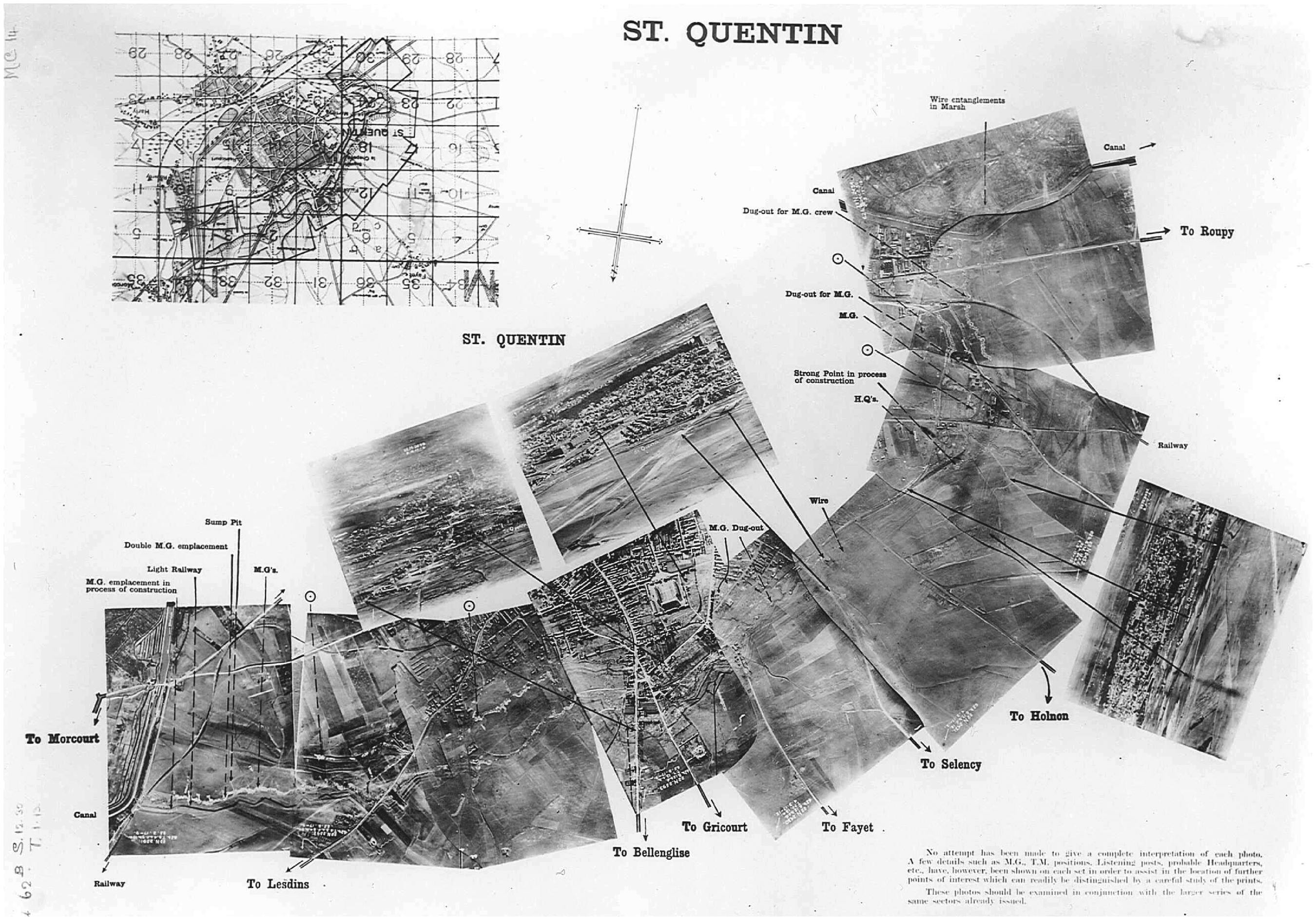
The aerial photomosaic came into widespread use as the photographic correlate of trench warfare. With sites of engagement stretching for many lateral miles, and with those miles of front supported and supplied, in turn, by extensive behind-the-lines networks, trench warfare made massive swathes of territory tactically relevant and therefore subject to reconnaissance overflights by the fledgling air services on both sides. The limitations of the aerial camera and its heavier-than-air platform, however, and the need to use telephoto lenses from an altitude above artillery range, meant that no individual image could capture very much ground at a resolution high enough to be useful to photographic interpreters.
5
In order to provide coverage of significant portions of front line and supporting positions, reconnaissance pilots flew in switchback lanes, making exposures at regular intervals in such a way that each image would overlap about 20 percent with the adjacent images in its lane, and each lane overlap, in its turn, with the lanes that bordered it (see Figure 2.) To ensure the verticality of the coverage, the plane had to fly as level as possible; to minimize blur, the pilot had to avoid lurches and vibrations. Once the film had been developed on the ground – often very rapidly, in cramped, lorry-mounted darkrooms – the prints were scaled to one another, fitted together to produce a continuous image, and glued to a drawn map of the same scale. The mosaic itself was then photographed, and that image labeled, reproduced at high speed and in massive numbers – again, by workers toiling in factory-like conditions – and disseminated (see Sekula, 1975: 28). ‘The time and energy saved by this process is enormous’, writes Harold E. Porter in 1921, having been a captain in the US Army Air Service during the war.
A whole county can be photographed in an hour or two, and a mosaic and map made of it in a few days; whereas to do the same work by an ordinary survey might take a couple of months. Besides, there are no surveying gangs in the front-line trenches. (1921: 164)
6
Simply put, the problem was to decide what was there and to act on that decision before ‘whatever it was’ moved. If the entity in question fell into the category of ‘enemy’, its destruction by artillery fire, or by other means, was ordered. The value of aerial photographs, as cues for military action, depended on their ability to testify to a present state of affairs. The photographic sense of ‘having been there’, identified by Roland Barthes, must submit to the demands of ‘being there.’ … The meaning of a photograph consisted of whatever it yielded to a rationalized act of ‘interpretation.’ As sources of military intelligence, these pictures carried an almost wholly denotative significance. … Within the context of intelligence operations, the only ‘rational’ questions were those that addressed the photograph at an indexical level, such as ‘Is that a machine gun or a stump?’ In other words, interpreting the photograph demanded that it be treated as an ensemble of ‘univalent’, or indexical, signs – signs that could only carry one meaning, that could point to only one object. Efficiency demanded this illusory certainty. (1975: 27–8) Diagram showing relations among altitude, exposure interval, area covered, and mosaic overlap in a single lane of aerial survey coverage. Source: Ives (1920: 298) Partial photomosaic of St Quentin, First World War. Note the three supplementary images showing oblique views of features on the vertical crescent; photo interpreter’s annotations; and the accompanying map, upper left, oriented with the photomosaic. The original caption, lower right, reads: ‘No attempt has been made to give a complete interpretation of each photo. A few details such as M.G. [machine gun], T.M. [trench mortar] positions, Listening posts, probable Headquarters, etc., have, however, been shown on each set in order to assist in the location of further points of interest which can readily be distinguished by a careful study of the prints. These photos should be examined in conjunction with the larger series of the same sectors already issued.’ Source: Collection of the Imperial War Museum, London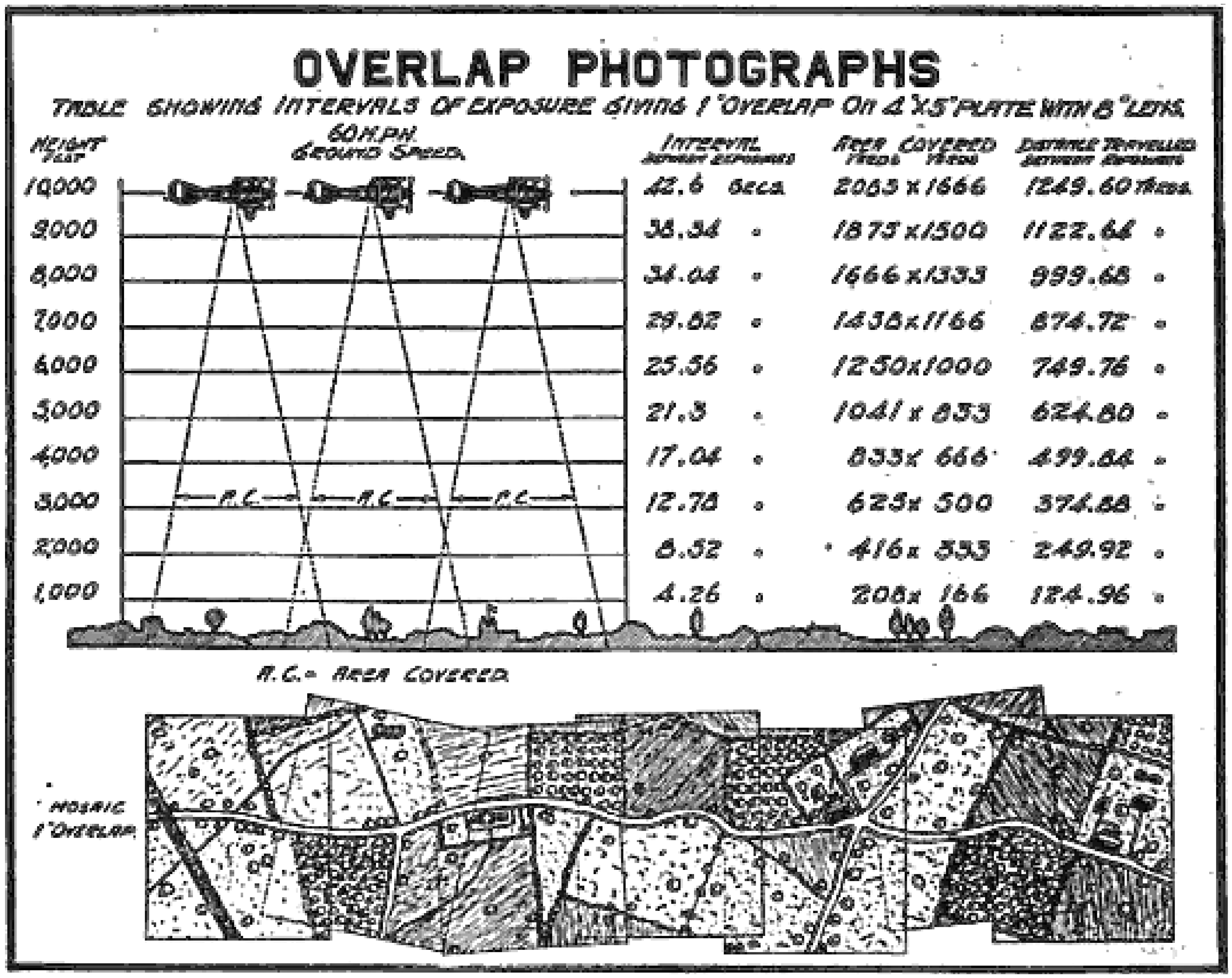
For Sekula, this rationalist, instrumentalizing conception of the image is ‘illusory’ because the same image may be resignified in another, peacetime context – imbued, for instance, with a rhetorical structure, a claim on the beautiful, or the glamour of an authorship-relation. I suggest, however, that instead of being celebrated during the war exclusively as the ‘triumph of applied realism’ (the phrase is Sekula’s), aerial reconnaissance was understood by First World War practitioners not only as accurately denotative but also as crucially defamiliarizing, revealing objects only in proportion as it deformed both the geometry and the temporality of human vision. We have already seen how the open book of the enemy’s intentions became legible to photo interpreters only after they had attempted to rectify the errors inherent in the image-taking. Interpreters who used hyperstereoscopy didn’t just correct for errors but actively exploited the delirious depth-effects inherent in their technique. And if a revelation that comes of abandoning the spatio-temporal norms of visuality sounds remarkably like the pre-war avant-garde, at least a few souls in the RAF seem to have made a similar connection in labeling varieties of landscape ‘“ ‘ “ ‘ “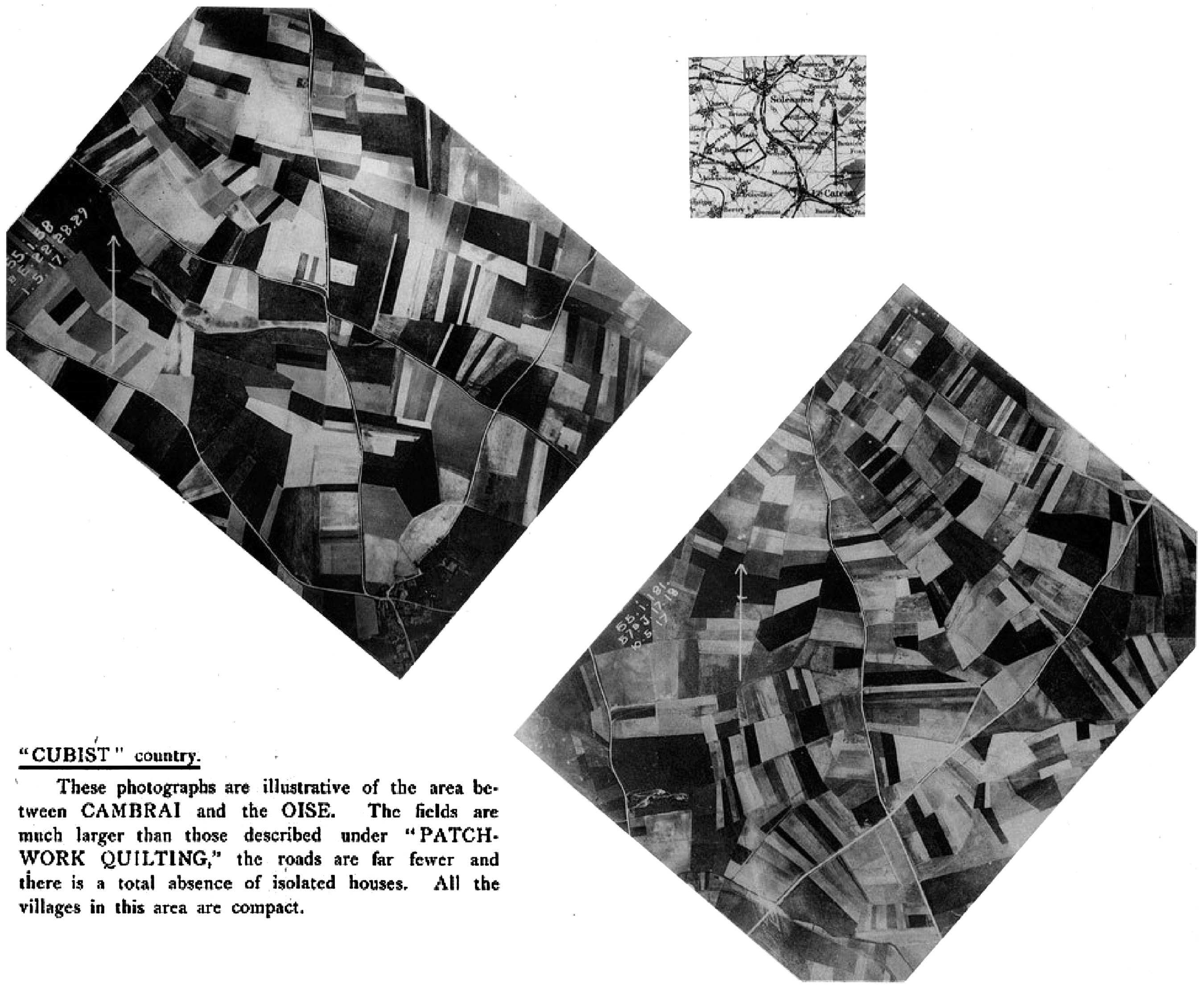
1920s Civilian Air Surveys
I have argued that aerial photography’s departures from the conventions of a perfectly scaled orthographic map were a chief source of its use during the First World War. When that technology was transferred to civilian practices after the war, however, the distortiveness that made it tactically useful in war appeared unseemly in peacetime, as if avant-garde optics could only be tolerated in the nakedly oppositional context of battle. The result was a widespread reapplication of the language of realism to aerial mapping. But this resurgence of realism-claims was not just a way of making a wartime technology safe for civilian use. It also registered the fact that the precision mapping demands of civilian photogrammetry required, if anything, more severe manipulations and counter-distortions to make aerial photomosaics conform to the conventions of cadastral maps. Elaborated to the point of spawning a discrete profession, these photographic and trigonometric rectification techniques needed a compensatory super-realism – a set of exaggerated claims about the accuracy, transparency, and self-decryption of the medium – as a rhetorical counter-distortion. But while the disfigurations, discontinuities, and site-specificities Ihave called ‘applied modernism’ could be banished to both the optical and rhetorical peripheries, they could not be eliminated. It will be our task in what follows, then, to read the modernism at the margins of peacetime photogrammetry.
As Figures 3 and 5 illustrate, most wartime photomosaics were assembled at speed, with minimal attempts to hide the seams or the exposure, scale, and parallactic differentials between neighboring photos. But these gaps and differentials could be significant. To begin with, the mosaic’s constituent photographs were seldom perfectly vertical – that is, seldom taken with the vertical axis of the camera’s lens exactly perpendicular to the ground or projection plane – because camera-bearing aircraft were easily thrown out of level flight by turbulence. Fluctuations in the plane’s altitude caused changes in photographic scale from one exposure to the next. And even if the plane flew at a perfectly consistent altitude, scale remained a problem. In any photograph, there are as many scales as there are depth planes. This continuum of scales is advantageous in most photographic contexts, as the greater scale of foreground objects contributes to the impression of their proximity over background objects, giving the viewer non-parallactic depth cues. But in aerial photos that would be used to rectify existing maps, a consistent scale was essential. In vertical photos of topographically extreme terrain, the scale in which valleys appeared could differ noticeably from that of mountaintops; likewise, in an urban environment, with streets versus the tops of skyscrapers. While the relief displacement – the radial ‘leaning’ of objects away from the vertical photo’s nadir – may have been essential to aerial stereoscopy, it played havoc with the planimetric and orthographic conventions of most maps, in which projection lines are perpendicular to the projection plane rather than converging toward the perspective center. And the shadows of tall objects could produce areas of pseudoscopy – the reversal of relief effects – on a photomosaic if they were oriented improperly. As Herbert E. Ives put it:
Even when ‘corrected’ and retouched, aerial photographic mosaics could present weird effects: in maps of cities, buildings sometimes look concave instead of convex because the shadows are falling away from rather than toward the viewer, particularly if the map is conventionally oriented with North corresponding to the viewer’s ‘up.’ (1920: 353)
One method of controlling photomosaics was to plot the photos to an identically scaled line-map of the terrain, whereby discrepancies between mosaic and map would guide rectification of the photos. Here we arrive at the photomosaic’s mimetic mise-en-abîme: a medium supposedly capable of correcting and even supplanting less accurate, less informative planimetric line-maps relied on those same maps to point up its optical waywardness. If lone aerial photographs distorted the terrain, they at least did so in much the same way the eye did, reproducing the relief displacement, the scale-differential at varying altitudes, even the flatness of the unaided aerial view. In the controlled, orthorectified context of the photomosaic, hundreds or thousands of fitted prints were made to represent not a humanly perceptible view of the terrain, but an imaginary view exempted from the situated optical traits of parallax and scale differentials. Finally, having been rectified, controlled photomosaics were retouched in order to conceal the composite mode of their production. Tonal variations among adjacent prints were regularized by the application of a red dye to the negative; lines from shadows cast by the edges of overlapping prints were painted out (Abrams, 1944: 228–9). By eliminating its seams, the mosaic’s makers gave it an artificial unity of perspective, uniformity of scale, and temporal simultaneity. A photographic form that revealed camouflage had itself been camouflaged, its contingencies disguised or leveled so that it resembled an idealized schematic as seen by a disembodied observer. Canonized by intelligence personnel, surveyors, police, entrepreneurs, and city planners as the utmost in photographic realism, the mosaic was, perversely, considered ‘accurate’ only in proportion as it bent the rules of optics away from perception toward orthogony. Aerial photomosaics ended up reconsecrating as ideal the very cartographic abstractions they were meant to correct or supersede.
After the Armistice, some of the reconnaissance workers trained during the war remained in national air corps, mapping colonies, mandates, and protectorates (as in the British case) or arguing that photogrammetry research and development should continue despite postwar military budget cuts and disarmament (as in the US).
9
Others applied their military training in civilian mapping projects, both privately and publicly funded. In France, according to Goddard, a law passed shortly after the signing of the Treaty of Versailles required all cities above a certain size – several hundred in all – to be surveyed aerially by civilian companies. Territory laid waste during the war was also surveyed by the French Army Aerial Photographic Service, in many cases because property lines had been effaced and local archives destroyed in the fighting (Goddard, 1969: 101 n 5).
10
Whereas French aerial photographers were put to work in a reparative relation to the destructive work they had abetted during the war, US reconnaissance veterans were sometimes described as bringing the war’s adversarial energies to American cities. Nelson P. Lewis, a consulting city planning engineer with the Russell Sage Foundation, extolled the virtues of a repurposed photogrammetry that retained aspects of its wartime strategic uses:
We know that aerial surveys and mapping were of the greatest possible use during the World War in locating points within the enemies’ lines which were vulnerable to attack, but we have found that this same method of aerial photographic surveying will disclose the logical points of attack for those who are bent, not upon destructive but upon important constructive work, upon thebetter utilization of natural conditions for commerce, for homes or for wholesome recreation. (Lewis, 1922: 212) [the] mapping use of airplane photography has been to a certain extent set back by the war, for the reason that certain scientific views [e.g. the chemical development of color-sensitive emulsions that could help reveal camouflaged objects], which are not relevant to commercial photography rather held the foreground. (Brock and Holst, 1919: 705–7)
11
The catalyst for this debate was the postwar emergence of companies such as Abrams Aerial Survey Corporation, Aero Service, Brock and Weymouth, and Fairchild Aerial Surveys, which began to make increasingly detailed photomosaic maps of US cities. Fairchild’s 1921 (see Figure 6) and 1924 maps of New York, in particular, were widely discussed and publicized in newspapers, aviation weeklies, scientific monthlies, and city planning journals, eliciting rapturous celebrations of the new form’s beauty, accuracy, and myriad uses; the latter were said to include recording city growth, informing current zoning and future planning, correcting errors in extant line maps, revealing traffic problems and untaxed buildings, even allowing police inspectors to ‘note the location and details of every roof exit, scuttle hole and skylight’
12
(see Fairchild, 1924b: 16–17; Unsigned, 1922a: 253–5, 1922b: 113–19, 1922c: 46, 1924: 37:3). Some revealing moments of ekphrastic rapture came from the photographers themselves, who wrote puff pieces for their own projects. Here is Sherman M. Fairchild, who would become the most celebrated civilian figure in interwar aerial surveying, describing the enormous photomosaic map of New York City that his company completed in 1924:
The map pictures the city with the minutest detail. It shows every structure from contractor’s temporary tool shed to skyscraper; back-yards, gardens and parks with every tree and bush visible; avenues and alleys, streets and unrecorded footpaths; big league ball parks; water-front clubs, with their yachts and motor boats; the boardwalk of Coney Island, and the crowds of people appearing like small black dots. Even the congestion of traffic on busy thoroughfares is clearly shown. (Fairchild, 1924a: 74) Detail, photomosaic of Manhattan by Fairchild Aerial Camera Corporation, taken 4 August 1921. The caption reads: ‘This Mosaic was made by assembling 100 Aerial Photographs taken while flying over the area at an altitude of 10,000 feet.’ Source: Fairchild Aerial Camera Corporation (1921)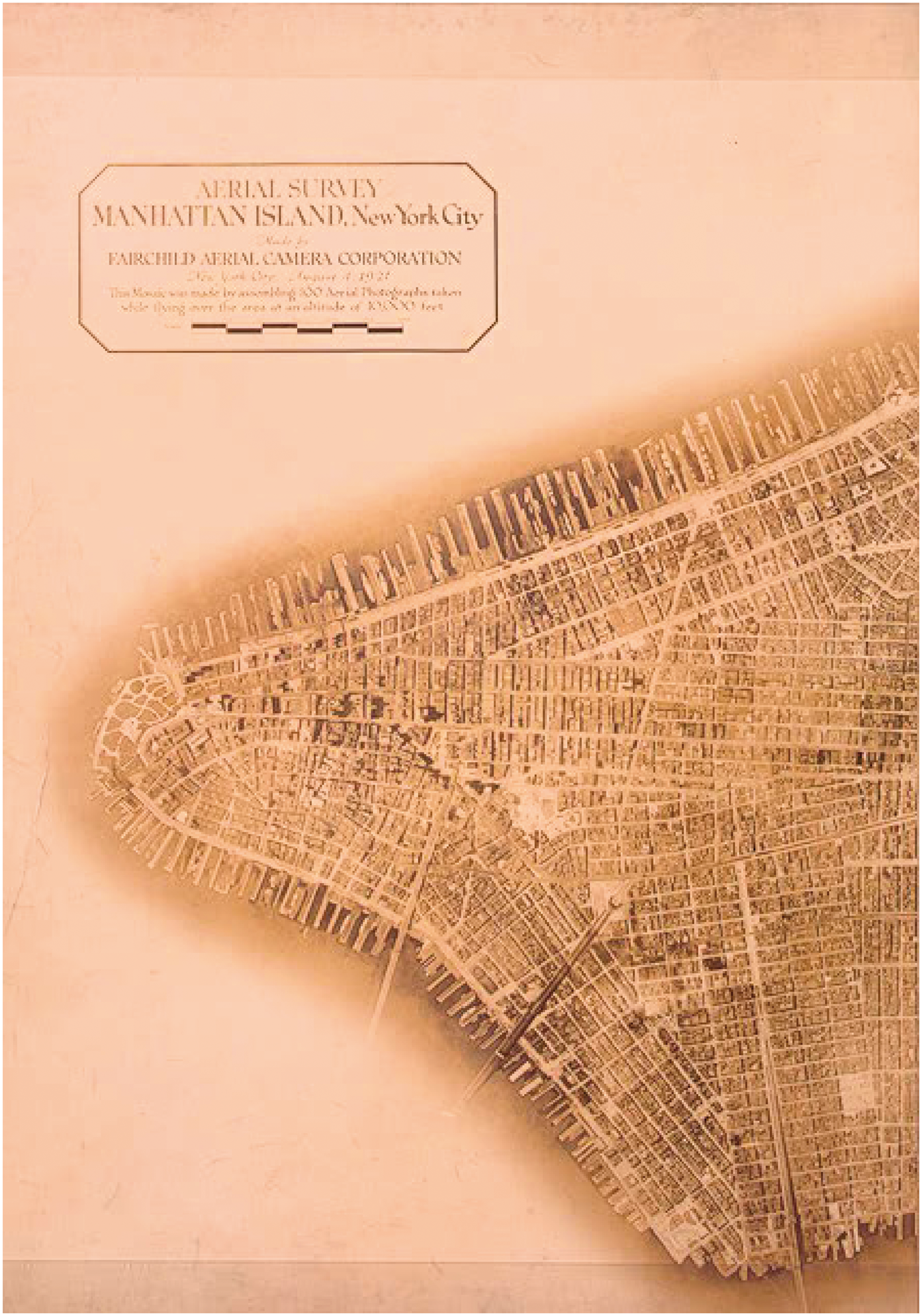
But of course a photomosaic map expansive and detailed enough to reveal a rooftop laundry line could not reliably inform one of the day of the week on which that particular rooftop had been captured. Fairchild’s boast about aerial surveys – ‘Mrs. Smith’s washing can be seen hanging on the line, so you know Mrs. Smith’s wash day even if you don’t know Mrs. Smith’ (Fairchild, 1922: 219; quoted in Light, 2003: 132)
14
– not only extends the wartime figuration of the photographic interpreter as Sherlock Holmes, it also participates in a fantasy of simultaneity and temporal precision that was increasingly belied by the production of aerial photomosaics as they grew in scale and resolution during the 1920s. Like reconnaissance coverage of the Western Front, early postwar surveys such as Fairchild’s 1921 Manhattan mosaic could be assembled from photographs shot during a single flight (‘New York Mapped by Sky Camera in 69 Minutes!’ declared one headline [Unsigned, 1922c: 46]). But the larger scales subsequently demanded by urban planners required many more photographs per square mile; whereas the 1921 map consisted of 100 photographs taken by a single plane (see Figure 7), the 1924 map combined 2000 photos taken by three planes over the course of several months.
15
The protracted period of image-capturing was due not just to the sheer number of individual photos involved but also to the fact that, as one of Fairchild’s accounts put it, ‘Few days are suitable for photographic mapping work’ at such a high level of detail (1924b: 16).
16
Shots could be ruined by low clouds, haze, smoke from the soft coal used in nearby factories, or high-flying clouds whose shadows darkened patches of the city. The shoreline had to be photographed at low tide for consistency’s sake and to capture as much dry land as possible. But protocol favored midday photography to minimize shadows and the pseudoscopic effects they could produce, so shoreline runs were confined to clear days when low tide fell no later than 2 p.m. Days with snow on the ground were out, so the camera planes were grounded for much of the winter, during which the rectification and assembly of mosaics were the agency’s principal focus. In the completed mosaic, the still containing Mrs. Smith’s washing lines might be adjacent to a photo taken only seconds later on the same day, or it might be blended with a neighboring photo taken months later at a different time of day, its slight shadows leaning in a different direction, its foliage in another seasonal phase. Far from presenting an aerial view of New York at a discrete moment – on a given Tuesday, a given washday – the Fairchild map stitched and smeared together photos taken from a variety of places and instants under a variety of conditions. As much as it was annexed to the cartographic fiction of an eternal present, it was in fact a miscellany of moments, a highly disciplined crazy-quilt of the city in time.
Overlapping exposures and flight lanes in urban photogrammetry. Original caption reads: ‘A diagram, showing how thirty-two square miles of New York was [sic] plotted and photographed in sixty-nine minutes with a Modern Aerial Mapping Camera. Below is a cross-section diagram, showing the method of procedure.’ Source: Unsigned (1922b: 116)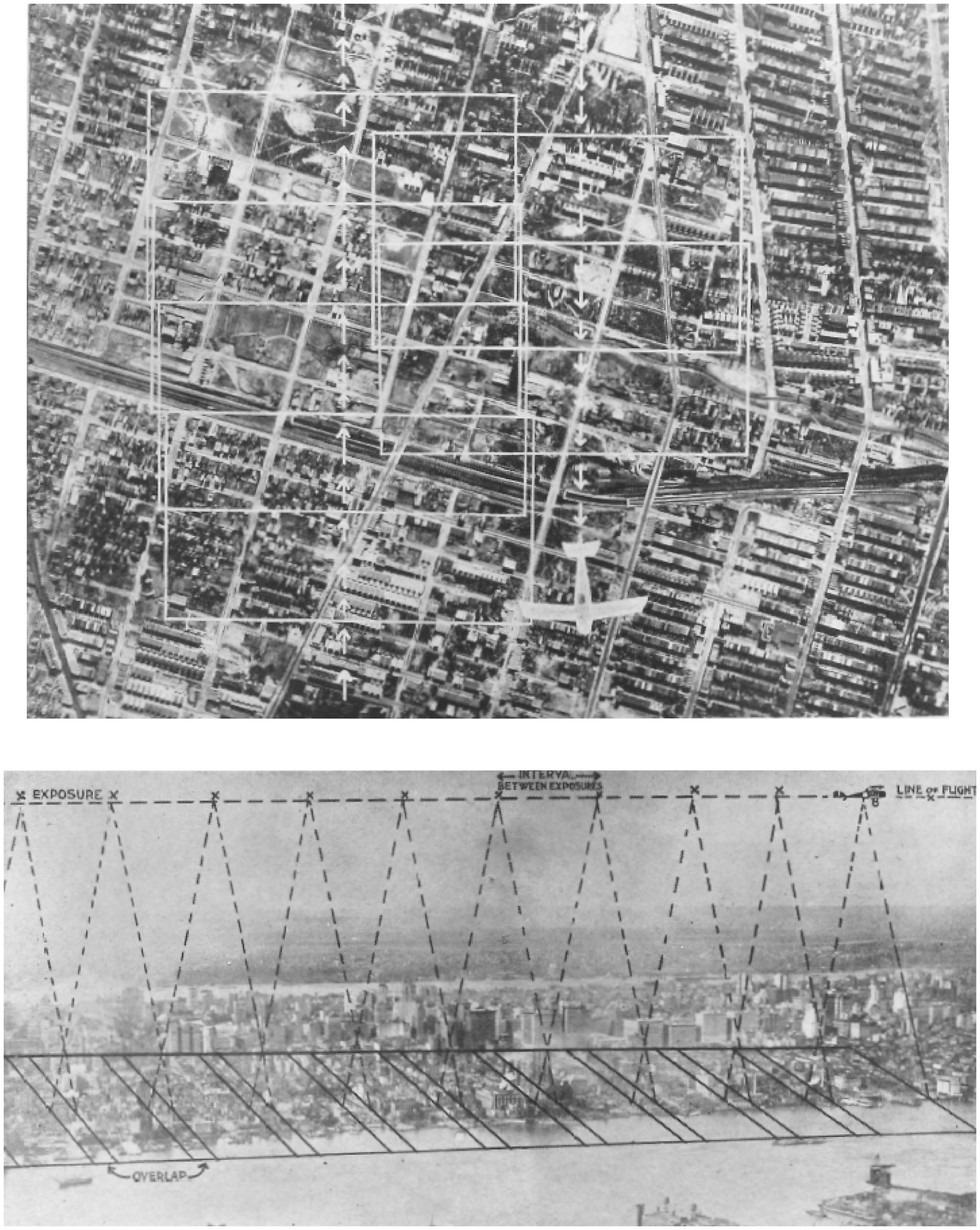
Fairchild’s boast actually leads us to a question: what happens to clock- and calendar-time in a city whose photogrammetric self-portrait is a concatenation of thousands of moments, many of them flung far from one another? Can any discrete thing be said to have happened, or to have left a legible trace of its happening, when it has been almost indetectably merged with both near-simultaneous and radically non-simultaneous images? What – in the silent ligations of such an image, or in the city that takes such an image as its self-portrait – is the status of an event? To be sure, the celebrants of aerial city-mapping invoked certain events – break-ins, riots, traffic jams, natural disasters and human-made emergencies – that photomosaics could help abate or prevent. In this, the proponents of 1920s aerial mapping as an urban planning tool simply replicated the adversarial stance of wartime reconnaissance, which established a baseline of ‘condition’ against which to measure unwelcome events it would then eliminate or forestall. These nods to eventfulness constructed it as the exception that validated the rule, the rule in this case being the uneventful time of the unblemished grid. Yet despite this seeming lock-step between planimetric seeing and the timeless state of the condition, there remains in both the discourse and the practices of Fairchild et al. a captivation with events that cannot simply be adduced as proof of the aerial survey’s utility, events in excess of exception-that-proves-the-rule rhetoric. These are exceptions that prove no rule: workaday ones, such as the hanging out of a stranger’s laundry, or more momentous ones, such as the Carpentier–Dempsey championship fight, which a Fairchild plane photographed from the minimum legal altitude of 2000 feet over Boyle’s Thirty Acres in Jersey City on a rainy night in July 1921. (The aerial coverage of the event allegedly beat the ground photos into distribution [Unsigned, 1922b: 114, 117].) We might think of such glimpses, such stunts, as eventful flickers on the periphery of the mosaic gaze, and as testimony that that gaze, for all its affinities with the general and the structural, was made entirely out of flickerings of the particular.
Earlier I described as ‘applied modernism’ this flickering quality of the aerial photomosaic, with its patchwork temporality, its indelible discontinuities, and its subtle exposure of orthography as a conjuring trick that summons an impossible image from resistant pixels. The photomosaic testified, in short, that seeing was a situated act: not a condition but an eventful apprehension of events, along a sightline in relation to which other visible objects are perspectivally displaced. However we think of this particular modernism – as a cunning assemblage of technologies, as an anti-Cartesian correlate of avant-garde painting, as a scopic regime of late modernity – we can at least insist on its opposition to the schematizing modernism of, say, Le Corbusier, for whom, as for Lowell Thomas, the best way to see and to plan a city was from the air. Note, however, that the applied modernism of the photomosaic does not oppose the schematic and – let’s say it – totalizing modernism of Le Corbusier and others from the ground, via some emphasis on local performances and pedestrian enunciations that evade the all-seeing aerial eye. 17 Irreducible to either the street-level practices of the flâneur or the totalizing gaze of the planeur, the mosaic disrupts critical and spatial reflexes stabilized by the likes of Barthes and de Certeau – reflexes by which we project all authority, distance, and spatiality onto the universal vertical axis and all resistance, locality, and temporality onto the horizontal. 18 Instead, the photomosaic shows us how the always-situated optics of vertical seeing can reverse verticality’s misrecognition as the necessary axis of the planner, the bomber, the sovereign. It asks us to consider what forms of derealization and coercion depend and thrive on horizontality. 19 And it suggests, more broadly, that an ethics of situated perception might oppose the totalizing view from nowhere without ceding to that view, or to those viewers, the project of comprehensive portraiture.
Coda
As of December 2009, the largest spherical-panoramic image in the world was Jeffrey Martin’s 18.4 gigapixel photograph of Prague.
20
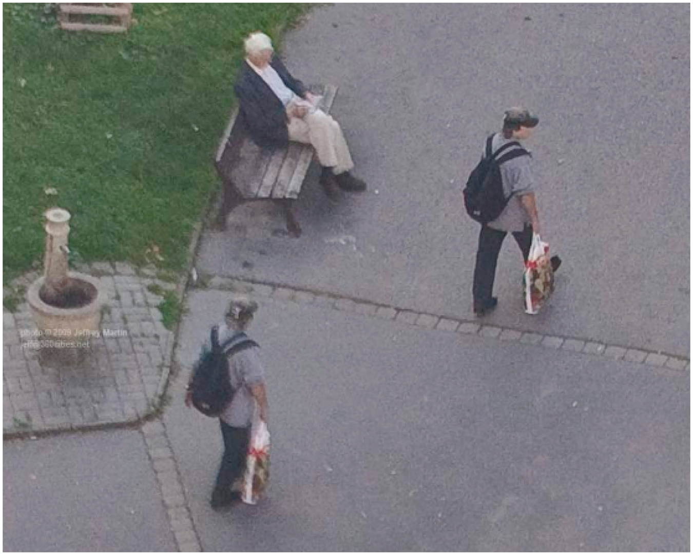
Shot with the help of a robot platform at the top of the Žižkov TV Tower, the image is oblique in varying degrees, approaching vertical only when one navigates so as to look at the ground at the base of the tower. Nonetheless, Martin’s image may be the closest we can come to experiencing the delirium of Fairchild-era aerial surveyors asthey first shot and then assembled the first detailed photomosaics of US cities and got lost in the plenitude of detail. In fact, Martin’s 2009 image isitself a photomosaic: ‘Hundreds of shots were shot over a few hours’, says the accompanying description; ‘these shots were then stitched together on a computer over the following few weeks.’ That stitching was done by sophisticated software called PTGui, specially designed not only to fit digital stills into navigable 360 × 180-degree panoramas but also to correct automatically for tilted and rotated images and to blend seams, match tone, mask anomalies: to do digitally, in seconds, what interwar aerial surveyors did over many hours using backlit ground glass, special printers, stretchable photographic paper, dodging and burning, scissors, pins, and glue. Yet because its hundreds of constituent stills were shot over the course of several hours, the Prague panorama – like Google Earth, at high enough resolutions – is vexed by weird effects of temporal parallax that descend directly from interwar aerial surveying. To take a single, haunting example (Figure 8): not far from the TV Tower, west by southwest, a roundabout called Škroupovo náměstí encloses a circular park, on whose perimeter walkway a gray-haired man sits on a bench reading a book. Just in front of him are two pedestrians clad in baseball caps, blue backpacks, and jeans. Both carry multicolored plastic shopping bags. Two pedestrians, five strides apart – who are clearly the same person photographed twice. (Maybe it is you.) Martin’s digital SLR camera, turning incrementally on its automated tripod, has caught one person in two consecutive images a second or two apart, and PTGui has stitched them together so the seam between the two images is invisible. But the software doesn’t automatically paint out optical twins, and Martin has either missed this instance of inadvertent doubling or mischievously let it stand. Yet it is not the pedestrian’s street-level viewpoint that gives us this anomaly or Easter egg, but the pedestrian as captured from a high vantage whose supposed immunity to time founders on those two proximate bodies and falls to pieces. Verticality undone by verticality. So there you are – having walked unwittingly in a few strides through the wall between two moments, two photographs – in two places at once. Against the static background of Prague seen in its structure, an event.
Detail from Jeffrey Martin’s 18.4-gigapixel panoramic digital photomosaic of Prague, released December 2009 Source: Martin (2009)