
Abstract
Climate change is certain, given the sufficient evidence for it. Thus, it needs to be integrated into the process of spatial and community planning to empower communities so they can adapt to it. This study addresses the critical gap in the literature on community planning and climate change adaptations by creating planning methodologies based on the participatory method, and simulating application of the process to the Saebat Maeul community in Busan, Korea. In the Saebat Maeul community, the study area, people have struggled with urban flooding, which is related to the poor sewer system and heat waves. Green infrastructures were used as the main tools to mitigate the negative impacts of climate change. The suggested community plan includes physical and socioeconomic measures, such as new parking structures with green roofs and pervious pavement, drainage facilities that reduce flooding, repairs to homes with cool roofs, and installation of rainwater harvesting facilities to lower the impact of heat waves. If planners have proper knowledge about climate change and if they guide the participatory planning process (thus reflecting local knowledge and suggestions), we concluded that it is possible to consider climate change adaptations within the context of spatial and community planning.
Keywords
Introduction
Climate change is a significant threat to both current and future human existence. Recent discussions regarding climate change adaptation and urban planning emphasize integrating adaptation measures into land use and spatial planning using a participatory process (APA, 2011; IPCC, 2014).
Various planning tools recently developed for participatory climate change adaptation include the U.S. Climate Resilience Toolkit (US Federal Government, 2014) and Cooperative for Assistance and Relief Everywhere (CARE) Community Based Adaptation (CBA) Toolkit (CARE, 2010).
Such planning tools suggest various methods for understanding of climate change adaptation and community, such as risk mapping, transect walks, asset inventories, and livelihood surveys, including scenario planning (Moser and Stein, 2011; van Aalst et al., 2008). Spires et al. (2014) demonstrate the practical application of planning tools to CBA through analysis of 21 cases. However, some literature discusses the limitation of planning tools and guidelines of CBA. The limitations are the lack of application clarity (Olhoff and Schaer, 2010), the insufficient number of case studies using the planning tools of CBA (Picketts et al., 2012), and the tensions surrounding the integrating of CBA and formal climate change policy by government (Forsyth, 2013).
Climate change inevitably deals with future uncertainties, and the benefits of adaptation are difficult to predict short term; hence, planning based on participation and collaboration is required. Aspects to consider would include how a community’s future will be handled, what kind of agreement and action will be taken in building a community’s future, and whether or not these can be discussed in the framework of planning.
Scenario planning applies corporate foresight and response measures to planning. The purpose of scenario planning is to develop strategies, to promote mutual understanding, and to reach agreement through participation to build capacity (Zegras and Rayle, 2012). Strategic spatial planning is the outcome of a goal that can be achieved through planning, and it pertains to the processes and tools required to create a better place (Bryson and Roering, 1996). Thus, scenario planning and strategic spatial planning can be applied to the community planning process for integrating climate change adaptation.
This study aims to create a community adaptation planning process by incorporating both scenario and strategic spatial planning methods into a general planning process and to apply the developed process to the Saebat Maeul community in Busan, Korea. The first part presents a theoretical discussion pertaining to CBA. In the second part, the case study and planning process are presented. In addition, by presenting simulation results for the determined plan, this study demonstrates the predicted outcomes of the plan created based on participation. The fourth part discusses the participatory strategies, roles of planner as facilitator, and integration problems from the experience of this case study. The final section presents the suggestions to future research in the field of CBA.
Theoretical discussion
Climate change adaptation and community
Some cities begin their community planning process with a discussion of how to implement and mainstream climate change adaptation (Revi et al., 2014; World Bank, 2011). Although cities are well suited to play an essential role in climate change adaptation, the question remains at what level of spatial units such a role would be possible. CBA recommends “community” as the urban spatial unit that can promote successful adaptation. A community adaptation plan based on local participation allows the identification of mechanisms that affect local climate change. The integration of scientific information and local knowledge then facilitates the learning and planning process and assists with effective implementation of the suggested actions in the plan (Burch, 2010; Livengood and Kunte, 2012; Reid et al., 2009; Roberts, 2010).
CBA includes the following four concepts (CARE, 2010; Reid et al., 2010). First, CBA is a community-led process based on local needs, knowledge, and capacity. Second, CBA empowers the residents of communities to create a climate change adaptation plan and methods for implementing it. Third, CBA enables the integration of climate change adaptation strategies with development strategies designed to address the needs of the community. Fourth, CBA is a mechanism that identifies the risks associated with the impact of climate change by combining scientific information and local knowledge.
CBA focuses on identifying local characteristics, researching strategies and actions, and deliberating on short-term adaptation measures. The identification of local characteristics refers to stimulating awareness regarding future risks, exposure, and vulnerability within the community to explore the knowledge and resources with which to build capacity and lessen the impact of adverse events (Dodman and Mitlin, 2013; Livengood and Kunte, 2012). Strategies and actions signify specific measures sought by individuals and households in the community to reduce the risks associated with climate change (Adelekan, 2010; Douglas et al., 2008; Kiunsi, 2013). Finally, community deliberation concerning short-term adaptation implies the sharing of the knowledge of climate change risk through a participatory process and the formulation of a collective rationale for preparing practical adaptation measures (Kiunsi, 2013).
Participatory tools and strategies for community-based adaptation
This study seeks to establish a climate change adaptation plan based on local participation and a collaborative decision-making process to build local knowledge. The demand for local knowledge in the context of climate change adaptation begins with understanding the limitations of existing scientific information (Gaillard and Maceda, 2009; Ryser and Halseth, 2008). The uncertainties of long-term forecasts and the spatial downscaling that existing climate change-related scientific information provides are not always consistent with the realities experienced by the community (Bishop et al., 2013). A community’s experience as it pertains to adaptation-related local knowledge can be examined by surveying community members and thus ascertaining stakeholders’ experience, as well as by conducting a site survey. This is possible via various methods, including community scenario development, needs assessment, community mapping, and a stakeholder analysis (Cilliers and Timmermans, 2014; Mercer et al., 2009).
However, the mere existence of various participation tools may not guarantee community participation, because climate change adaptation is still a novel subject that has not garnered much attention by most community members (Few et al., 2007; van Aalst et al., 2008). Therefore, planning strategies designed to ensure robust community participation are needed for a successful implementation of CBA. Strategies to boost community participation may be discussed in the following ways.
First, there is the integration of community development and climate change adaptation. Although it has long been discussed in exploring the relationship between climate change and sustainable local and regional development, the argument that short-term local development and pertinent benefits must accompany adaptation is gaining attention (Klein et al., 2007). The logic is that a community’s various issues need to be addressed comprehensively, and as part of climate change adaptation, in order to avoid or reduce the unintended consequences of adaptation (Adger et al., 2005; Dovers, 2009). To ensure effective adaptation, the theme of climate change adaptation must be incorporated with local and community development strategies (Blanco and Alberti, 2009; Ewing et al., 2008).
Second, adopting and implementing a green infrastructure benefits adaptation at the community level and provides an opportunity to build a better environment. A green infrastructure offers diverse benefits, such as rainfall runoff control, non-point source pollution management, urban agriculture, landscape, and recreational space (CNT, 2010). Integrating vegetation-based adaptation and mitigation refers to the concurrent promotion of adaptation with regard to heat waves, air quality, rainfall runoff control, mitigation of greenhouse gas emissions, and energy conservation which are main impacts caused by climate change in the community level (Pataki et al., 2006).
Third is the integration of scientific information and local knowledge (Crate and Nuttall, 2009; Magistro and Roncoli, 2001). The concept of climate change adaptation can be divided into holistic thinking and analytic thinking. The latter, which focuses on scientific information, separates climate change impact, vulnerability, and risk elements in order to identify their individual effects. Holistic thinking, on the other hand, focuses on connections between elements and their integration. In a community, in particular, scientific information pertaining to climate change can be integrated with local knowledge (Katz et al., 2002).
Community for the case study and planning processes
Community chosen: Saebat Maeul community of the Busan metropolitan area in Korea
The spatial scope of this study is an urban community. The term community is not legally defined in South Korea, but the equivalent conventional term in Korean is Maeul: a place where people settle and live together to form a community, a basic social group residing in a specific locality with a common culture. Hence, this study has defined a community’s spatial scope as a Maeul. We selected Saebat Maeul community in Hakjang-dong, Sasang-gu, in the Busan metropolitan area as suitable for the purpose of this study.
Saebat Maeul community is located at 29-31 Hakjang-dong, Sasang-gu in the Busan metropolitan area (Figure 1). The total area of Saebat Maeul community is 0.113 km2 and is occupied by 1277 residents, 6.9% of whom receive the means for their basic livelihood from the government, and the elderly population constitutes 41.6%. Saebat Maeul community, located in an area surrounding the Hakjang River, is between a residential housing complex and the Sasang industrial complex, which was built in the 1970s to provide housing to workers of the Sasang industrial complex. The area devolved into a slum when the workers started to move out of the area with the decline of the manufacturing industry in the 1990s. Overall, Saebat Maeul community is known as a relatively vulnerable community in terms of its local environmental attributes and social conditions. In regards to its environmental attributes, Saebat Maeul community has experienced flooding due to its low elevation next to the Hakjag River (Busan Daily, 2009) and is exposed to dust and odor from the Sasang industrial complex (Yun and Kwon, 2014). In regards to its social conditions, Saebat Maeul community has a concentration of dated and deserted houses, a lack of infrastructure, a low educational level, and a high proportion of elderly people (Kim and Seo, 2016). These conditions make the Saebat Maeul community vulnerable and highly sensitive to climate change in the future (Kim and Seo, 2016).
Saebat Maeul community.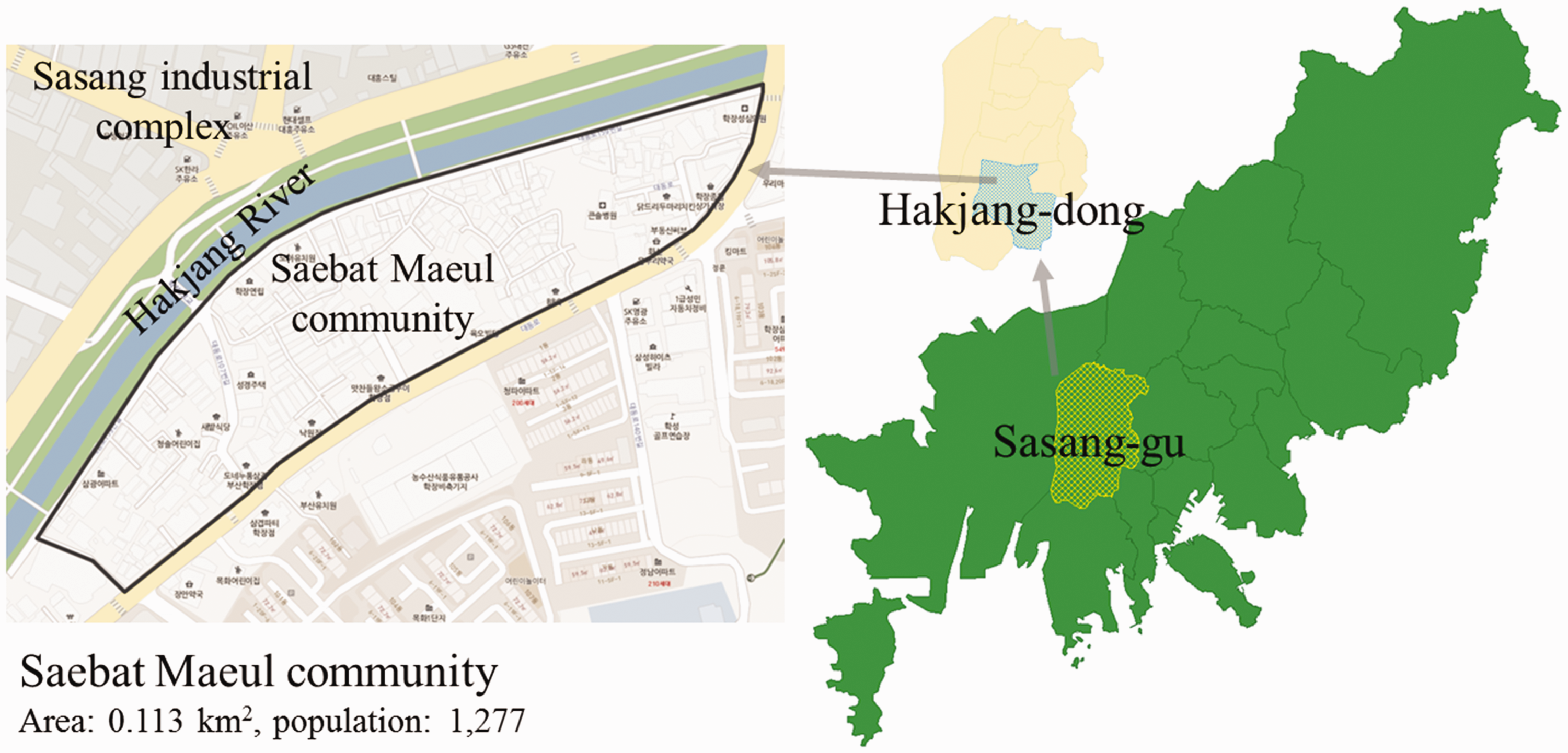
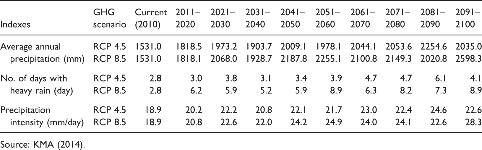
To establish a community plan that integrates climate change adaptation, we began with a review of the impact of climate change on the area. Of the various indicators of climate change, heat wave and heavy rain indexes became the focus because they tend to present the most negative effect on cities in South Korea (Kyselý and Kim, 2009; Ministry of Environment and National Institute of Environment Research, 2010, 2015). According to the Korea Environment Institute and Gallup Korea survey (2012), half of the nation’s population thinks that climate change will reach a threatening level in 10 years. Based on these results and general time span for community planning, 2025 was chosen as the target year for the implementation of the community adaptation plan.
Heat wave indexes in Sasang-gu (predicted future trend).

Source: KMA (2014).
Heavy rain indexes in Sasang-gu (predicted future trends).
Source: KMA (2014).
Communicative strategies and planning process
A community plan that targets both climate change adaptation and community development through a participatory workshop is based on a communicative process among community members, stakeholders, and the planners. Unfortunately, climate change adaptation is still an unfamiliar concept to a majority of community residents and stakeholders. Therefore, effective communication, which is essential, may be approached with the following strategies.
First, the term “climate change” was replaced with “more hot weather” and “more rain.” Thus, by starting a conversation pertaining to the summer weather issues relevant to the community, we attempted to draw the attention of the community members and stakeholders. Furthermore, the term “green infrastructure” was softened with such terms as “park,” “garden,” and “open space,” which were incorporated into the physical plan for presentation to the community later on. Because an aggressive push for climate change adaptation is not likely to draw local participation, community development was highlighted, and adaptation strategies were incorporated with a focus on the function of facilities.
Second, help from community coordinators and interviews with community members were used as intentional strategies for enhancing communication. Community coordinators are specialists designated to ensure smooth implementation of community revitalization projects in Korea. Taking advantage of this networking ability, we established a strategy in which the coordinators acted as a medium between community members and planners for effective communication.
The planning process consists of six steps as shown in Figure 2. First, the participant and planning groups are defined, and the community characteristics and issues related to climate change impacts are identified through a communicative process. Based on the findings, the participation and planning groups both begin working to reach an agreement. For this, the alternatives suggested by both groups are reviewed and modified through participatory workshops and community member interviews. This process includes coming up with an alternative upon identification of community needs and defining the issues. Subsequently, the community’s scenario is prepared and the solution is determined for the plan. Finally, the results and findings of the processes are combined to produce the first draft of the community plan, and then detailed projects are established through the community workshop.
Steps and characteristics of the planning process.
The text mining method is used to compile the opinions of the community members and to identify their needs to determine the community context. Community members’ needs are identified with atypical and non-structured data provided freely by the community members, and then the relationships and patterns between the identified needs are analyzed to approach the key issues of the community. Community member interview data and verbal data produced in the workshop are analyzed and organized through text mining techniques, such as keyword analysis and word clustering, frequency analysis, and association rule analysis. Frequency analysis involves examining how often the determined keywords are used in order to identify the size and the intensity of the needs. In association rule analysis, the cause-and-effect relationship was identified between the keywords in order to connect them with the needs. Such a text mining technique allows a systematic approach to communication with the community members.
This study estimated the effects of climate change adaptation by implementing actions adopted in the community plan created through local participation and the communicative process. Quantitatively measured knowledge of the effects of a plan through simulation and modeling can help residents and decision makers to establish and adopt the plan. The effects were examined in terms of reduction in heat waves, surface water runoff, and non-point source pollution.
For estimating heat wave reduction, ENVI-met® 3.1 was employed, and for surface water runoff owing to heavy rain and non-point source pollution, LIDMOD2 was used. ENVI-met® 3.1 is a software that produces a three-dimensional microclimate model used to simulate the interaction between surface-vegetation-atmosphere within the city environment. This program simulates interactions between individual buildings, surfaces, and vegetation by calculating radiation, reflection, and re-radiation from building systems and vegetation, as well as from evapotranspiration and heat flow (Ambrosini et al., 2014). By performing the ENVI-met® simulation, we can analyze the reduction in urban heat island effect through changes in buildings, surfaces, and vegetation in accordance with the plan.
Jeon et al. (2010) developed LIDMOD2 by modifying the Site Evaluation Tool (SET) from Tetra Tech in the US to suit South Korea’s hydrological conditions for effect analysis. LIDMOD2 is a tool for helping to estimate the reduction in rainfall runoff and non-point source pollution for a plan that incorporates green infrastructure. For evaluating land use, current land use and proposed land use data are entered under pervious area and impervious area. LIDMOD2 has been applied to various case studies to estimate the effect of green infrastructure of land use planning in Korea (Jeon et al., 2010; National Institute of Environment Research, 2009).
Findings
Preliminary investigation and identifying the target community’s context
The preliminary investigation of the target community consists of the community basic status survey, resident interviews, community map composition, and deduction of issues. The literature review indicated that the target area sustained two flooding events, caused by the overflowing of the Hakjang River in the 1990s after heavy rain; and various waterway projects—including sewage pipe and storm sewer pipe renovation, reforestation, and waterway expansion—have been carried out. However, no specific measures were in place for heat waves aside from the establishment of cooling shelters.
As shown in Figure 3, Saebat Maeul community site survey zones were divided into the riverside zone, the poor housing zone, the commercial zone, and the residential housing zone.
Designing site survey zones (a) and conducting resident interview (b).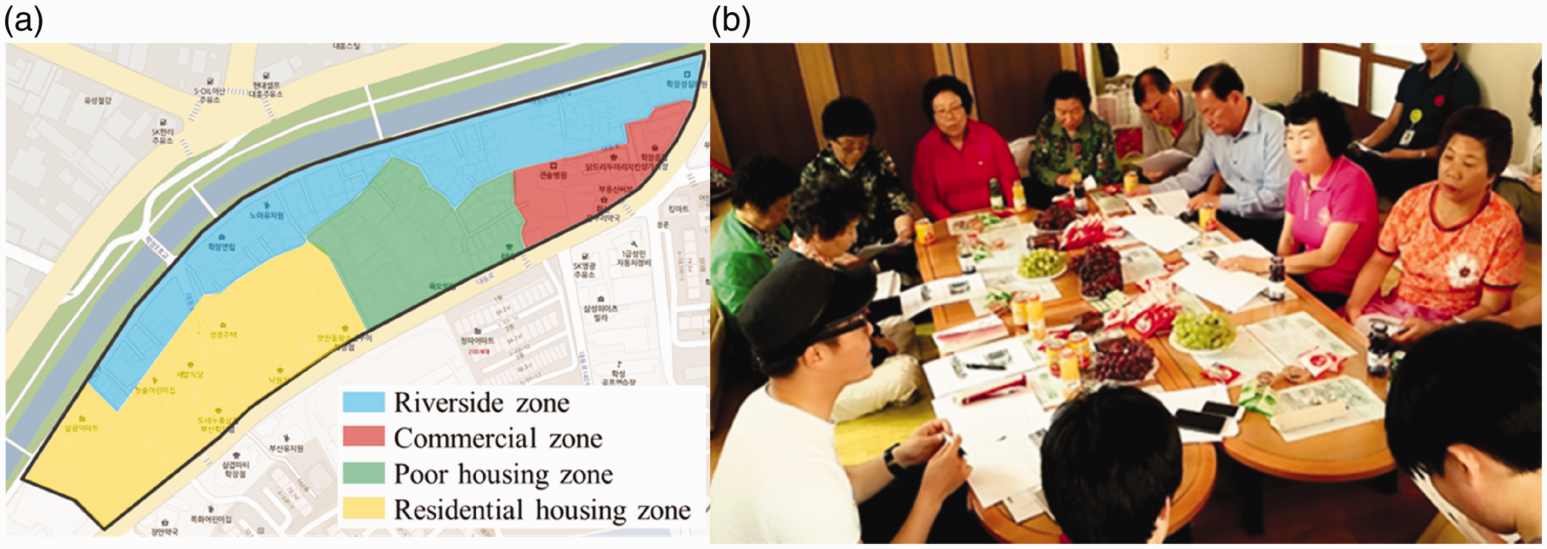
In the first zone, the riverside zone, the condition of the pavement on most roads was dismal. A halted waterway project and the neglected riverside environment made it difficult for the residents to use the surroundings. In the second zone, the residential housing zone, abandoned, and severely dilapidated apartments occupied its center, which residents of the community pointed out as a risk factor for crimes and accidents because of poor safety. The third zone, the commercial zone, was found to be in need of renovations as shoppers felt reluctant to go and visit the dated and deteriorating buildings. As for the fourth zone, the poor housing zone, various murals had been painted on the exterior walls of the houses, but the desired effect was not achieved owing to the lack of a unifying theme. Additionally, insufficient installation of security cameras posed a crime risk, and drainage holes dug on the roadsides served as a poor substitute for an actual drain system, which would obviously be inadequate during heavy rainfalls. Furthermore, dangerous stairways, poor road pavement conditions, and narrow village roads were found to pose a risk to pedestrian safety, as well as causing issues in responding to heavy rainfalls and emergency situations. The results of the site survey and interviews indicated the problems summarized in Figure 4.
Problems identified through Saebat Maeul community site surveys.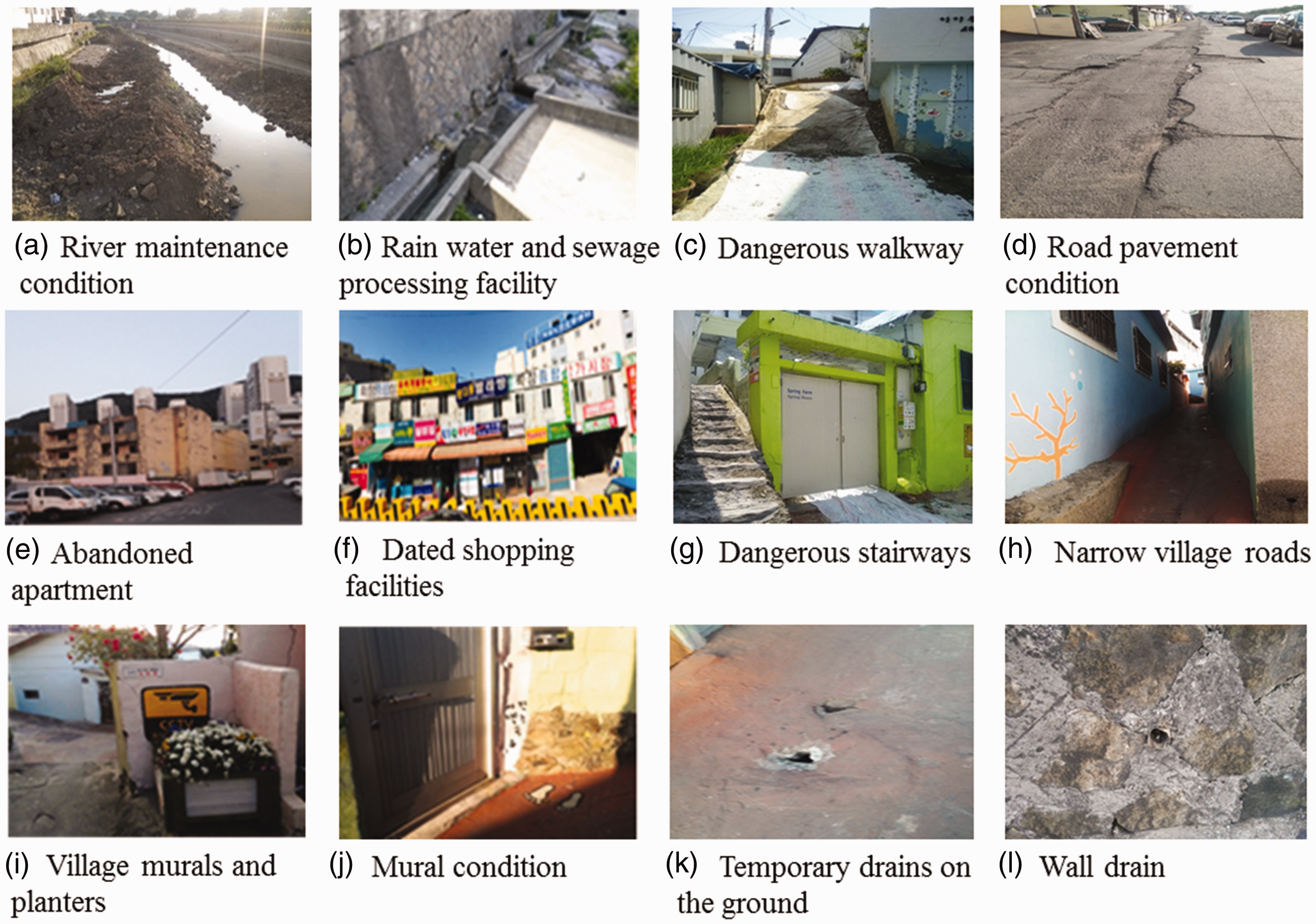
The second process pertained to identifying the target community’s spatial context. The concept for the plan was established according to the community needs determined during the keyword deduction process. With a focus on resident interviews, five keywords were identified which are presented in Figure 5.
Discovering needs through Saebat Maeul community text mining (a), plan concept analysis results (b), and Saebat Maeul community goal scenarios (c).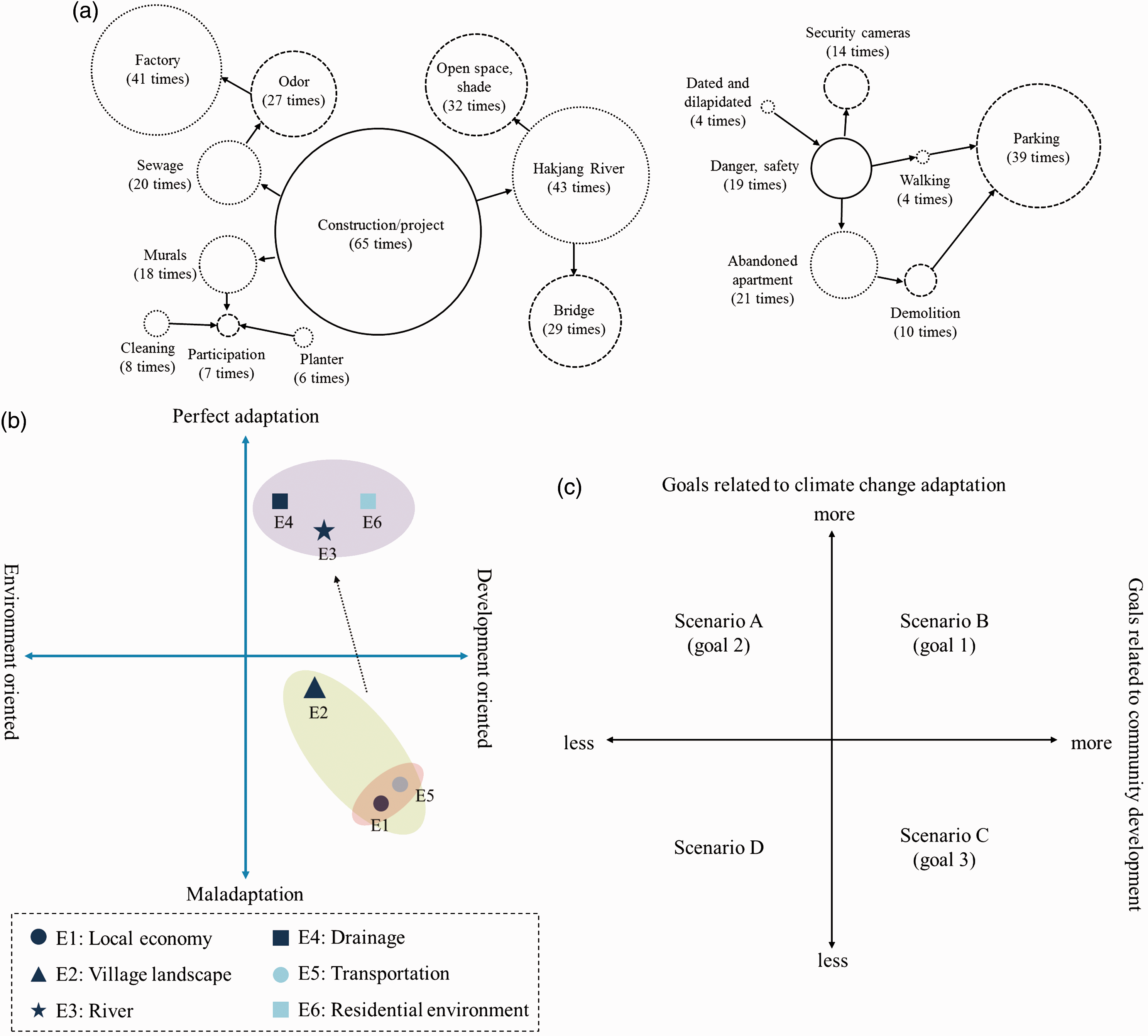
The area in which the community expressed the greatest need was construction/projects. These needs include revitalizing and using the Hakjang riverside, addressing the foul odor generated by the manufacturing factories, and finding solutions for the murals and lack of community participation. In terms of the Hakjang riverside, identified needs were related to the Hakjang River cleanup and maintenance, as well as to drainage channel/sewage maintenance projects currently in progress. Open spaces, shade, and bridges were suggested, which can generate a synergy effect in the effort for climate change adaptation and the improvement of the residential environment as it pertains to Hakjang River construction.
Concerns regarding construction/projects include community participation, especially in relation to the murals, as well as for cleaning and maintaining flowerbeds. We discovered that conflict occurs among community members regarding the level of participation in community projects; complaints and dissatisfaction emerged regarding the mural project and other maintenance burdens.
Regarding needs apart from construction and projects, various issues were connected to keywords involving danger and safety. Abandoned apartments, pedestrian safety, security cameras, aging buildings, etc. were revealed as major concerns. With regard to walking, we found that issues of parking were in serious need of attention. Although these needs should be a priority in community development, residents’ understanding about these issues varied, as well as their demands.
Based on these community needs, six plan concepts were determined for Saebat Maeul community: local economy, community landscape, drainage channels, river, traffic, and residence. Then, the characteristics regarding the determined plan concepts were identified. It was discussed whether themes in the plan were development oriented, whether it incorporated climate change adaptation, and, if not, whether there was a possibility for change. Through this discussion, factors such as the location of the residents’ needs, the type of roles they play within the space, and the direction of change could be revealed.
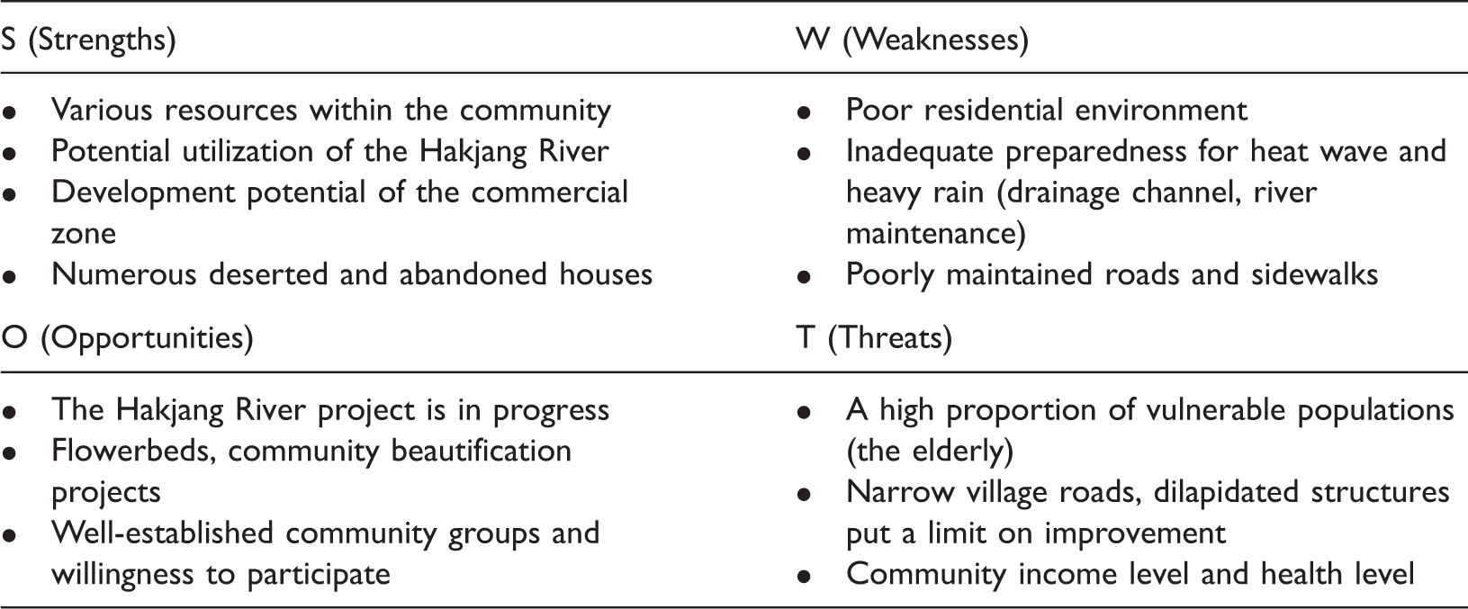
SWOT analysis results of the first Saebat Maeul community workshop.
Setting goals and establishing scenarios for the target community’s plan
The goals of the Saebat Maeul community plan were established based on the results of the community needs analysis (Figure 5), available community resources, and changes in plan concept direction. The keywords identified for the community are connected in three aspects. First, the community’s need for parks and shade can be connected to the Hakjang River constructions along with the sewage and drainage system projects. Second, the parking issue in the community can be addressed by connecting it with the abandoned apartments, and the odor problem can be connected to the green areas around the Hakjang River. Third, the community’s needs for more security cameras, street cleaning, and flowerbeds can be addressed through the community association and safety-related plans. The keywords determined from community needs reflect both climate change adaptation and community development. The keywords were used to make goals and establish scenarios for community development and adaptation. Three goals were set based on the needs analysis of the community and are connected to the three community scenarios determined at the community workshop, which are presented in Figure 5(c).
The first goal of the plan focuses on both community development and climate change adaptation, and incorporates the creation of common profits, strengthening of the local economy, and updating and maintaining basic infrastructure. The first goal connects the community’s needs to build a community center and public parking lot for the local economy and common profits with reducing the physical barriers to climate adaptation through improved infrastructure. Through the community workshop, the first goal addresses scenario B, which is simultaneously focused on climate change adaptation and community development, consisting of the construction of the Hakjang River, renovation of the sewage and drainage system, installation of security cameras, and revitalization of the community center.
The second goal focuses on climate change adaptation, and the plan includes expanding the drainage system, shade, cooling shelters, and increasing rainwater recycling. In this goal, the community’s development needs are met through the additional adaptation measures. Households will gain an economic benefit through cost saving as a result of the adaptation measures. The second goal is connected to scenario A, which is focused on climate change adaptation and consists of measures to establish greater protection from climate change-related natural disasters, such as heavy rain and heat waves.
The third goal focuses more on community development: it seeks to resolve the odor issue, which was found to have the most detrimental effect on the community’s development currently, and to address the safety issue through the resident association to foster tourism in the area. The use of a special color of cool roofs and the forest zone are included here, which can contribute to community development and climate change adaptation. The third goal relates to scenario C, which focuses on community development and pertains to improving the residential environment that forms the foundation of community development and economic development.
The planner group created three plan goals and scenarios in preparation for the second community workshop. Scenario B, which focuses on climate change adaptation, was selected as the main scenario; based on this decision, the details of scenarios A and C were modified. The final direction for the scenario was determined as follows: to create a community that exists with nature and is prepared for heat waves and heavy rain, to construct a landmark community with cool roofs and a walkable Hakjang riverside and to generate profits with the community center and neighboring small businesses.
Plan for the target community
A plan was created that distinguished areas designated for community development and climate change adaptation. Community development areas consist of the Hakjang riverside, community center, abandoned apartment complex, and rainwater processing facilities. The intended function of the walkable riverside was to attract tourists, and the function of the community center was to generate profits for the community. The abandoned apartment housing complex is to be developed into a paid parking garage, for which a multiple stage, solar-powered, green roof, eco-friendly parking lot can be considered. Finally, constructing a rainwater processing facility and employing rainwater recycling are intended to increase the rainwater resources utilization rate.
The climate change adaptation area can be divided into four parts. First, the drainage system can be redirected into a single place around the Hakjang River project. A forest zone can also be installed near the Hakjang riverside for the facilitation of shade. Cool roof and other unified roof zones are assigned within the community in general, and cooling shelter zones can be assigned.
The Saebat Maeul community plan is from the third community workshop and is summarized in Figure 6 and Table 4.
Saebat Maeul physical plan. Summary of Saebat Maeul community plan.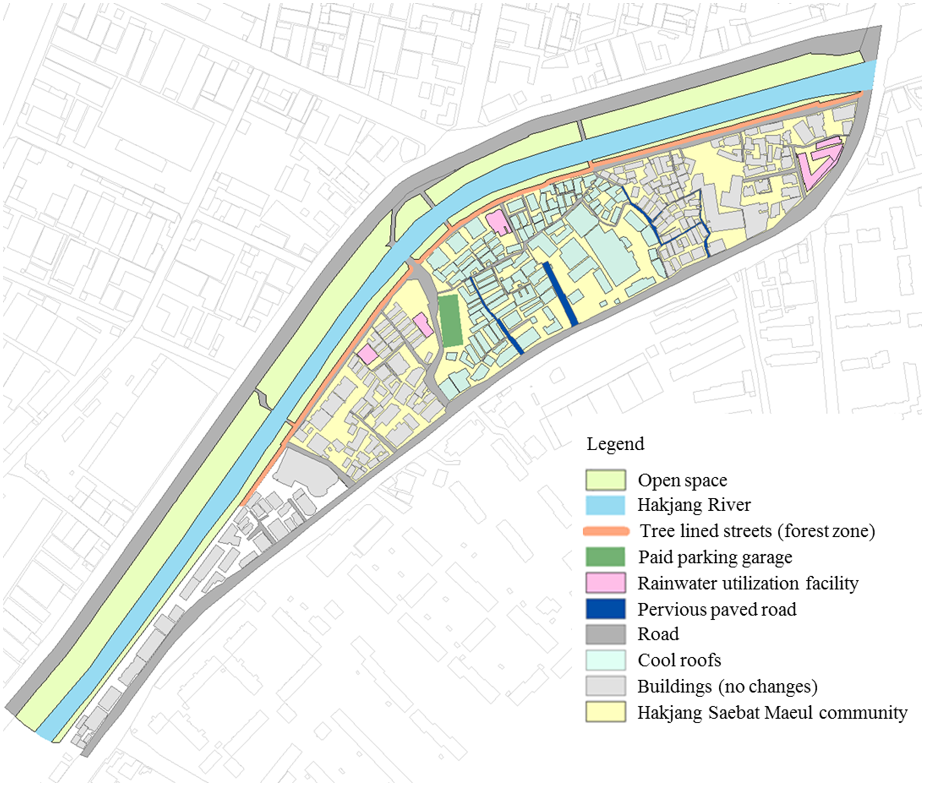

Based on the community physical plan, as shown in Figure 6, a heat wave reduction simulation was performed with the previously discussed ENVI-met. Using the HadGEM3RA model RCP 8.5 scenario’s 230 basic administrative unit (i.e. si·gun·gu) monthly data as KMA (2014), climate variables were entered for August 2010 and 2025. Because the RCP 8.5 scenario data do not include wind direction, the south wind was set as the default because it was the most prevalent wind in the Busan metropolitan area in August 2010, and we assumed that it will stay the same until 2025. Analysis results were as shown in Figure 7. Both the 2010 and 2025 results indicated a decrease in the normal air temperature at 2 p.m. by as much as 0.6℃, post-plan. The reduction in air temperature was greater around the Hakjang River, and the green roofs, parks, and areas around the riverside street trees were found to have a reduced thermal island effect in general.
Reduced thermal island effect according to an ENVI-met analysis of the Saebat Maeul community. (a) 2010's temperature pre-plan, (b) 2010's temperature post-plan, (c) 2010's temperature difference between pre-plan and post-plan, (d) 2025's temperature pre-plan, (e) 2025's temperature post-plan, (f) 2025's temperature difference between pre-plan and post-plan.
Saebat Maeul community’s surface runoff and non-point source pollution reduction effect as analyzed by LIDMOD2 mock results.
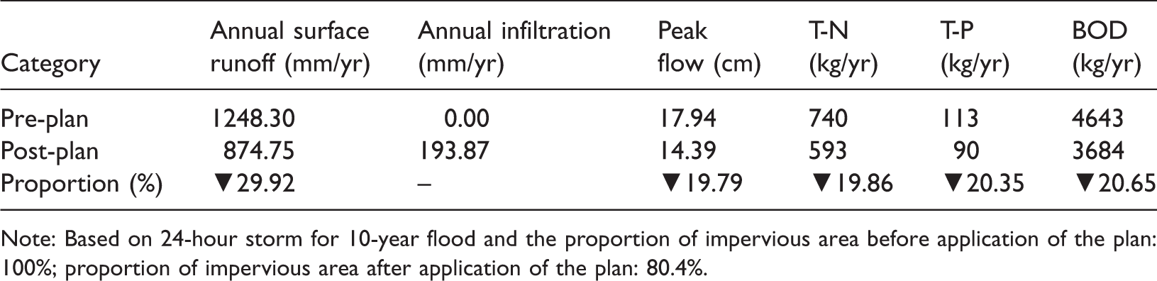
Note: Based on 24-hour storm for 10-year flood and the proportion of impervious area before application of the plan: 100%; proportion of impervious area after application of the plan: 80.4%.
The Hakjang River renovation project and lining neighboring streets with trees, building a parking garage in the abandoned apartment housing complex site and turning the roof into green areas, paving of village roads with permeable pavement, etc., were applied. Because the community currently does not have vegetation areas or parks, the impervious area accounts for 100%, which decreases to 80.4% after the plan is applied. As for additional best management practices, inlets were selected. The analysis indicated a 29.2% improvement in the annual surface runoff and an increase in annual filtration from zero to 193.87 mm. Peak flow was found to increase by 19.86%. As for the difference in annual pollutant loads, total nitrogen (T-N) improved by 19.86%, total phosphorus (T-P) improved by 20.35%, and biochemical oxygen demand (BOD) improved by 20.65%.
Discussion
This is the first case study example from Korea looking at the development of a community adaptation plan, applying theoretical discussions and the method of CBA to the Saebat Maeul community. Experiences and results gathered from this study can inform meaningful strategies for the participatory method of CBA to enact climate adaptation measures.
First, successful CBA requires a strategy to promote participation in the planning process, includes deciding on who should be included and how to organize the communication of the plan. As such, the strategy should examine a community’s characteristics, including who comprises the vulnerable classes and who sets the agenda for local residents.
Participation in the CBA process means including various community members and stakeholders (Leck and Simon, 2013). When applying CBA to the Saebat Maeul community, the involvement of these groups was essential and two benefits of participation were pursued simultaneously: developmental and instrumental suggested by Richardson (1983). The former refers to social capital and enhanced knowledge that may develop from the participatory process. As it relates to climate change adaptation, participation can raise awareness of climate change and build capacity to respond to it. Instrumental benefits pertain to a product generated from participation, which adds legitimacy to the process (Burton and Mustelin, 2013).
CBA must include vulnerable and poorer people as participants in order to increase its developmental benefit. In addition, in order to successfully implement the product of the participatory process, CBA should involve a party who can resolve local resource and funding issues, which are considered barriers to adaptation (Adger et al., 2007). In our study, individuals from the vulnerable classes, such as women and the elderly, as well as members of the local council and local government officials were invited through various channels to participate in the planning process. The results of the CBA planning process led to a community regeneration project, the implementation of which was approved and financed.
Second, as this study reaffirmed the utility of the participatory method for CBA, planners should play a key role in facilitating a wider application of the method. Since the 1960s, participatory planning has been suggested as one of the various approaches that can overcome the limitations of rational comprehensive planning, which is an expert-based and goal-oriented approach (Filion et al., 2007). Some spatial planners, however, believe that the decision-making process used for participatory planning could result in a backlash, and participation of the public rarely leads to a rational decision (Hiller, 2003).
Spires et al. (2014) conducted a comprehensive analysis of 21 case studies on CBA and found that cultural style of participation is a critical factor. They also suggested that a lack of adjustment and a disconnect between participants’ thoughts and an embedded institutional mind-set may interrupt the implementation of CBA (Spires et al., 2014; Roberts et al., 2012). In the case of the planning process in Korea, the cultural style or embedded institutional mind-set was a top-down style. Decisions were made by experts and bureaucrats who were striving to respond efficiently to rapid industrialization and urbanization. Furthermore, previous studies of public participation revealed barriers to engagement within Korean society, such as a lack of institutional measures, indifference, and perfunctory participation of local residents (Choi and Kent, 1993; Kwon, 1997). With inadequate institutional measures, local residents had little experience in engaging in a participatory process and, therefore, resorted to one-sided conversations to serve their needs in public hearings or on other occasions (Kim et al., 2009). Some research suggests that participatory planning failed to take root in Korea due to insufficient individual capacity (Kim and Won, 2013; Lee, 2009).
However, this study demonstrated that the issues related to participation have more to do with a lack of experience than with insufficient individual capacity. In sharing viewpoints on community issues during site surveys and attempting to identify community needs through a continuous communicative process, it became apparent to the planners that the residents simply were not well versed in expressing their opinions because of a lack of experience and opportunity.
Planners, thus, should assume an important role as a facilitator in CBA-applied participatory planning processes. Climate change adaptation as a co-learning approach is a challenging task that requires discussions of the future, expertise on adaptation, and local knowledge (Ayers and Forsyth, 2009; Dumaru, 2010). As a facilitator of CBA, planners should be able to act as mediators who connect local residents, stakeholders, scientific information on climate change, and local knowledge. This implies that planners could spend considerable time with a community (Ceccato et al., 2011; van Aalst et al., 2008), collecting local residents’ opinions and discussing them in the context of the community’s development and climate change adaptation (Renn, 2006).
Third, fostering integration and identifying adjustments required to meet a community’s needs must be carried out in order to pursue effective climate change adaptation. Previous studies on CBA indicated the importance of adjustment and integration among various needs such as a community’s interests, the extent of current climate change adaptation, and the perceived benefit of hazard reduction (van Aalst et al., 2008). CBA that utilizes participatory planning should focus on the needs and interests of people participating in the process (Burton and Mustelin, 2013; Scott and Baehler, 2010). CBA is not just about climate change or the environment and, thus, should deal with the community’s livelihood problems, rather than addressing the issue of climate change alone (van Aalst et al., 2008).
The product of the CBA process from this case study focuses on community development and its relevant needs. Participation founded on constant communication and mutual trust allows for the creation of effective and realistic community plans that incorporate local knowledge to solve a community’s issues. Such a planning process also provides an opportunity for concurrent community development and climate change adaptation. For this study, listening to residents’ complaints was a priority in order to help meet the community’s needs. The process allowed for the building of mutual trust between the planners and community members, thus contributing to the development of an effective plan from a common good perspective. The residents exhibited a great deal of interest in community development as well as in climate change adaptation.
Conclusion
This study selected the Saebat Maeul community for integrating a community planning process with climate change adaptation based on local participation. The planning process focused on resident participation and cooperation. According to steps 1–6 of the process, community participatory workshops were held, by means of which community needs were discovered and future scenarios created for the target areas. A community plan integrating community development strategies and climate change adaptation strategies was created; community projects were determined according to the plan, and communication channels were set up between the residents and the planning group.
Compared to other planning methods based on a top-down process, CBA requires more time and energy from planners due to the participation of the public. While this study examined only a single case of CBA application in a Korean community, it successfully proved the utility of CBA as suggested by theories and previous literature. It demonstrated that CBA could produce various adaptation measures through a consensus reached between locals and planners, promote the implementation of the plans by inviting appropriate people to the process in a way to guarantee the legitimacy of the participation, and integrate adaptation by putting the community’s needs at the center.
Finally, this study makes the following suggestions for future research on CBA. First, there is a need for a case study that expands the application of CBA to include a city’s generally vulnerable areas. Almost every city has a community where people from the vulnerable class live in concentration and even within a city of developed countries, there exist areas that are highly vulnerable to socioeconomic impacts such as climate change. Since these are important areas for a city’s sustainable development and require interventional planning for climate change adaptation, the method of CBA can be useful for the development of physical infrastructure and soft infrastructure. The application of CBA to a vulnerable area as a generalized community planning and development tool would help mainstream the issue of climate change adaptation in a city.
Next, future research should explore a planning process and a methodology of CBA application for urban renewal. CBA based on participatory planning can integrate climate adaptation measures by focusing on the needs for community development. Urban renewal is an effort to enhance a community’s socioeconomic elements as well as its physical infrastructure and is most likely to be realized when there are developmental needs. If an urban renewal process contains CBA, it could expedite the implementation of climate change adaptation. To that end, there needs to be a further discussion on measures and policies to mainstream CBA in the process and methods of urban renewal.
Third, there is a call for a study that explores the development of a national adaptation measure accepted by national and local government as well as communities. CBA is not a silver bullet that will solve every climate adaptation issue. As such, future research should determine, among all climate adaptation policies, which adaptation measure works best at the community level. By examining an adaptation measure that is most suitable at the community level, it could provide a standard with which researchers could identify and suggest linkages between CBA application and a community’s developmental needs.
Footnotes
Declaration of conflicting interests
The author(s) declared no potential conflicts of interest with respect to the research, authorship, and/or publication of this article.
Funding
The author(s) disclosed receipt of the following financial support for the research, authorship, and/or publication of this article: This study was performed by the basic research of Korea Environment Institute (2014-06).