
Abstract
This article examines urban planning on the outskirts of Maputo, Mozambique, where governance constitutes an ambiguous realm whose imagined opportunities are as enticing as its dangers are frightening. Although state agencies have proven incapable of implementing coherent urban policies, numerous peri-urban areas reflect a remarkable aesthetic regularity. In the article I unfold how it emerged through informal attempts to mimic state-defined urban standards which even civil servants acknowledge exist only as scattered imitations. It is when initiating building projects based on urban standards that the state could have implemented that house-builders create the ordering gaze of power by which they ought to be illuminated. Taking governmentality to refer to a form of reason that takes as its object the problem of the population, I argue that peri-urban planning in Maputo can be considered as inverse governmentality, that is, a form of reason that takes as its object the problem of governance.
There have been some attempts to establish a policy for urban land, but so far nothing has happened. In practice, the citizens make urban policy. The urbanization process stopped because it is costly but the people don’t stop. The people are urbanizing the city. (Maria da Conceição Quardros, Ministry of Agriculture)
House-builders living on the outskirts of Maputo, Mozambique, seem constantly preoccupied with governance. 1 ‘Government… what does that even mean?’ Arone Tembe, a portly man in his early sixties, was about to enter the office of the local municipal department for urban governance in Mulwene on Maputo’s northern periphery in order to (yet again) apply for use rights to a piece of land, when he decided to let me in on his thoughts. ‘Who is actually the government (afinal quem é o governo)?’, Tembe asked with a small shake of his head before proceeding to formulate a tentative response himself. ‘I suppose there’s always somebody acting as government.… Still, I’ve lived here since I was born and I’ve never seen anyone.’ For Arone Tembe and his fellow residents, this was the decisive question which caused bewilderment and incessant debates. Although people recognized the crucial significance of governance, they struggled hard to decipher what it was really about and how those doing it (whoever they were) had acquired such skills. To be sure, it was governance and not leadership which constituted the problem. Leaders could be found everywhere but most of them did not do anything worthwhile except preventing others from accessing collective goods. Governance, on the other hand, was considered as a skilful manipulation of those capricious and partially unknown forces which were always at play in the social universe. Obviously it was not only a dangerous manoeuvre; it was also the prerogative only of those experts (expertos) with sufficient knowledge to engage with potentially malevolent forces without suffering excessive harm. And, as I was constantly being told, when acts of governance were successful, the advantages were numerous. Samora Machel, Mozambique’s first president after Independence in 1975, undoubtedly knew how to govern and this enabled him to almost single-handedly drive out the Portuguese colonizers. In the local environment, anyone who visited a neighbourhood on the outskirts of the city would easily detect signs of skilful (‘good’) governance by its overt effects. According to residents in Mulwene, the increasing number of luxurious houses being built on parcelled-out plots was a clear indication that fortunate acts of governance had occurred. Although most of the houses were undoubtedly being erected without formal construction permits or legal use rights, their owners had managed to manipulate some unknown forces which made it possible to commence their building projects without being hindered by bureaucratic obstacles or, worse still, forcefully removed. Indeed, acts of governance were shrouded in an air of obscurity and desire which only intensified people’s attempts to uncover their secret potentials.
This article examines the mysteries of governance in peri-urban areas of Maputo, Mozambique. In particular, it focuses on the paradoxical production of peri-urban planning in a social setting where governance constitutes a partially unknown realm whose imagined opportunities are as enticing as its dangers are frightening. Neighbourhoods on the fringes of Maputo are fundamentally imprinted by the failures of incoherent political-cum-ideological schemes which increasingly seem to be co-authored by international lending institutions. Despite recurrent political announcements on the importance of individual property rights, few people make their way successfully through the labyrinthine administrative process. Instead, the majority of peri-urban residents access land through illicit transactions with corrupt civil servants or local chiefs who parcel out and sell off pieces of land to needy newcomers (Nielsen, 2007b). 2 In these predominantly informal areas, basic infrastructure is rarely the result of public initiatives. Rather, installation of electricity and water frequently occurs when civil servants are bribed to make individual connections, such as when (stolen) electricity pylons enable relatively well-off residents to become connected to the municipal network.
Surprisingly, the ambiguity of governance does not necessarily generate insurmountable problems as partial insight tends to be an overall premise for social agency. People in this part of Mozambique live in a social and cosmological world which they believe to be only partially illuminated. The surrounding universe is composed by competing forces which can only be seen and thus manipulated from unique positions such as those achieved by sorcerers through the use of magical substances (Honwana, 2003; cf. West, 2005: 44–5). It is not only through sorcery, however, that dangerous forces may be skilfully manipulated. Interestingly, the otherwise hidden potentials of governance are made accessible by appropriating certain key elements associated with state-authored urban planning. Through concerted efforts, residents who occupy land informally parcel out plots and build houses based on what appear to be officially sanctioned urban standards, for example regarding building materials and plot size. Still, as I will shortly show, not only have municipal and state agencies proven to be incapable of implementing coherent urban policies based on fixed regulations; also, those ‘standards’ which are used by illegal residents as basis for their house-building projects lack any juridical anchorage. Although clearly giving the impression of homogeneous urban governance, the regularity of peri-urban planning derives from individual or collective attempts to imitate state-defined urban regulations, which even civil servants acknowledge exist only as informal guidelines. We might argue, then, that the hidden world of urban governance is made manifest through imitations of an ‘original’ whose core features are unknown to governor and governed alike.
This overall idea of governance as praxis is perhaps best captured by the notion of ‘governmentality’ which was first introduced by Michel Foucault in an influential lecture at the Collège de France in 1978 (1991). Foucault here described governmentality as an art of government which has the population as its political problem. It is based on a political rationality which considers people as free citizens in a realm external to the state. This obviously problematizes governance whose political object is configured as something which cannot be controlled. In order to implement programmes of governance, it is therefore important to know everything about that which has to be governed and ‘to govern in the light of that knowledge’ (Rose et al., 2006: 87). Key sites of governance are outside ‘politics’, so to speak, and so governmental strategies need to be implemented by influencing and allying with agents who are not simply relay stations for the execution of the former (Collier, 2009: 87; cf. Latour, 1986). Although individual actions may come to buttress broader political objectives, resources made available through governmental strategies are frequently used also for idiosyncratic purposes. Hence, when a site of governance is also a point of potential resistance to any one way of thinking and acting, government needs to be understood as a ‘congenitally failing operation’ (Rose and Miller, 1992: 190). As Rose et al. succinctly argue, the existence of a governmental strategy does not imply either its generalized acceptance or its successful implementation (2006: 99).
In order to analytically apply Foucault’s notion of governmentality in a Mozambican context, we nevertheless have to perform a counter-intuitive move by which its overall logic is reversed. As outlined above, according to Foucault’s initial elaboration, governmentality refers to a form of reason that takes as its particular object the political problem of population (1991: 99–101). When exploring the paradoxical production of peri-urban planning in Maputo, however, we need to turn this thinking on its head and consider a (popular) form of reason that takes as its particular object the political problem of governance. In an unstable social setting where official governance agencies continuously fail to deliver what they have promised, the population projects governance as its problem rather than vice versa. This situation produces series of surprising effects. Although lacking clear knowledge about its fundamental logics, residents living on the outskirts of the city engage with governance by ‘inventing’ it (cf. Wagner, 1981) through illegal house-building projects. As I will show, it is when building cement houses in parcelled-out plots in accordance with urban standards that the state could have applied (but which it did not) that the activities of the house-builders come to create the ordering gaze of power by which they ought to be illuminated. The gaze radiates, as it were, back from its object towards its source which is thus supplied both with properties and form. It is this intricate process that I define as inverse governmentality and which, in the following sections, will be examined and elaborated upon.
Paradoxical peri-urban planning
In this section I present three case studies of peri-urban planning processes from three different neighbourhoods in Maputo. As a whole, they may be taken to crystallize the primary dynamics of inverse governmentality. I will subsequently proceed to historicize inverse governmentality as a particular form of urban governance before exploring in detail the creative potentials it conveys.
Case 1: Caught in the middle
The extravagant wealth of Maputo’s privileged classes is physically manifested by the growing number of luxurious mansions erected along the coast line bordering the Indian Ocean. Whereas only a decade ago this area was populated predominantly by informal residents living in scattered settlements, it has recently become a preferred housing location not only for international embassies but also for foreign traders in temporary positions and members of the local political elite. A close inspection reveals, however, that certain sections of the area fail to exhibit an overall aesthetic regularity. Wedged between the rows of impressive buildings, an informal settlement of 200 irregular plots with 1- or 2-room cement houses and smaller reed huts on stamped dirt platforms disturbs the image of landed wealth. Recently, the glaring contrast was further deepened when a bordering section was parcelled out for a building project which was planned to commence in late 2008. To residents in the informal area, building activities in the surrounding neighbourhood (bairro) have been particularly disturbing as they signal an imminent threat of being resettled when the municipality chooses to expropriate their plots. In April 2008, Boavida Sîtoe, a primary school teacher owning a plot in one of the four quarters (quarteirões) which constitute the informal area, realized that something had to be done to change the precarious situation. As a countermove intended to secure their continued occupancy, he contacted a local architect who had previously worked in the neighbourhood. Sîtoe suggested that the architect, Ismail Zamir, draft an urban plan for the informal area which mimicked what the municipality might have done with sufficient financial and human capacities. This plan, Sîtoe imagined, should delineate straight 8 metre wide roads separating blocks of 16 15 × 30 parcelled-out plots, a functional sewage system and basic street lights. The architect accepted the project although made it condition that he received half of his fee in advance.
Prompted by the neighbourhood chief, Zamir and Sîtoe jump-started the project by setting up a commission of residents to deal with those conflicts which would probably arise in the process of collecting money for the architect’s fee and later when aligning the irregular plots in accordance with an overall urban plan. The commission had two initial objectives which were to (1) make a convincing campaign which outlined the benefits of the urban plan; and if successful (2) collect money among the residents for the architect’s fee. After a tiresome process of endless meetings, both tasks were surprisingly accomplished. Although a few households refrained from participating at all, most residents realized the advantages of the urban plan and equally accepted to contribute to the architect’s fee. Based on the neighbourhood chief’s estimation of people’s overall financial conditions, they were asked to pay an individually determined amount which ranged from 700 MZM (US$25) to 5500 MZM (US$200). When half of the agreed fee was collected, Zamir commenced surveying the area. After two and a half months, this phase was concluded and, together with a colleague, he then spent the next one and a half months drafting the actual urban plan. On a hot Sunday afternoon in August 2008, the first draft of the plan was presented to the residents. Still, as predicted by the neighbourhood chief, all problems regarding the parcelling process were unfortunately not eliminated at this moment. According to Zamir’s plan, several households would lose parts of their plots in order for the area to acquire a relative homogeneous urban aesthetics (see Figure 1), and many initially refused to cede any land at all. More meetings followed before the plan was finally accepted also by those residents who were to lose parts of their plots. At a festive ceremony in December 2008, the plan was officially handed over to the president of the residents’ commission and to the district administrator. In February 2009, the plan was officially approved by the Maputo municipality and immediately forwarded to the Ministry of State Administration (MAE) where it now awaits its final ratification.
One version of the urban plan drafted by Zamir.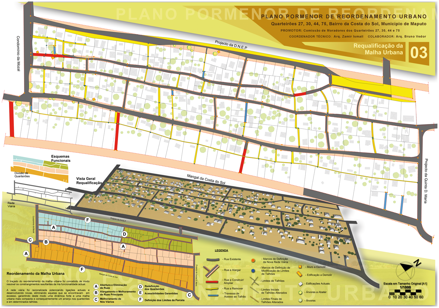
Case 2: Getting closer to the state
Mulwene is an emerging peri-urban bairro on Maputo’s northern periphery which has grown significantly since 2000 when it was used as resettlement zone for the many disaster victims after the devastating flooding which hit Mozambique in the first three months of the year. From a pre-flooding population of less than 2000, a continuous influx of people reached its temporary peak in 2005 when the neighbourhood had 30,813 registered inhabitants. A few years prior to the flooding, a section of Mulwene was parcelled out by the municipal department for urbanization (DMCU) 3 and, through the Ministry of Education, allocated to a group of needy primary school teachers. From the beginning, parts of this ‘Teachers’ Zone’, as it was soon denominated, were laid out as three commercial zones (zonas de comércio) intended for local residents to establish small shops. The realization of this objective, however, was impeded from the outset. When the DMCU made the first blueprint of the ‘Teachers’ Zone’, the area was already partially inhabited by small-scale farmers and, as the neighbourhood was gradually parcelled out after the flooding in 2000, more and more newcomers acquired land in the zones through local quarter chiefs and former plot owners. Thus, from the end of 2000, all three commercial zones were illegally occupied.
For people living in the ‘Teachers’ Zone’ (but outside the commercial zones), the process turned out to be beneficial, as it brought official parcelling (parcelamento) to their area, which ensured their continued occupation of it. Irrespective of whether they were, in fact, teachers or not, residents in the area were allocated 15 × 30 metre plots. For people living within the commercial zones, the situation was somewhat different. Obviously, they were prevented from being allocated formally parcelled plots, as their area was not intended for housing and so they continued to inhabit irregular pieces of land that lacked the orderly structure of the surrounding areas. When the area was parcelled out as the ‘Teachers’ Zone’, their status was consequently transformed from informal residence into illegal squatting, with the implicit threat of being forcibly removed.
During the first months of 2001, residents in the commercial zones were becoming increasingly frustrated as the current situation was obviously untenable. A small ad hoc committee was therefore set up by residents from the area with the sole aim of parcelling out the commercial zone so that it imitated the urban structure of the encircling neighbourhood. Fearing that uncontrollable conflicts might break out among those residents who would undoubtedly loose parts of their plots, the committee turned to Boavida Wate, a former quarter chief in the area, who agreed to lead the parcelling-out process. ‘It was at the time of the flooding,’ Wate remembered when we sat down to discuss the project. ‘That’s why we managed to open the streets.’ As Boavida Wate told me, the parcelling-out of the neighbouring areas made people realize the need for similar urban norms within the commercial zone.
Without a doubt, the conversion of the irregular pieces of land within the commercial zone into properly parcelled-out plots was anything but easy. According to current residents, all landowners had to cede parts of their land, especially those who lost land to the street traversing the area. In the years following the restructuring of the commercial zone, ongoing disputes and mutual allegations of wrongful appropriations of land gave a tense edge to social interactions which was still noticeable in 2004 when I first came to the area. These disputes notwithstanding, the restructuring of the commercial zone did have significant and concrete effects. As can be seen from the recently updated municipal map of the ‘Teachers’ Zone’ (see Figure 2), the middle block, which was previously parcelled out as six formal plots, has now been extended into the commercial zone, with six additional plots thus comprising parts of the informally parcelled-out area. Needless to say, this does not indicate a full formalization of the whole area. It does, however, suggest that the parcelling out of the commercial zone successfully transformed the status and localization of residents in the area.
Updated blueprint of the ‘Teachers’ Zone’. The black rectangle indicates where the six additional plots have been parcelled out within the commercial zone.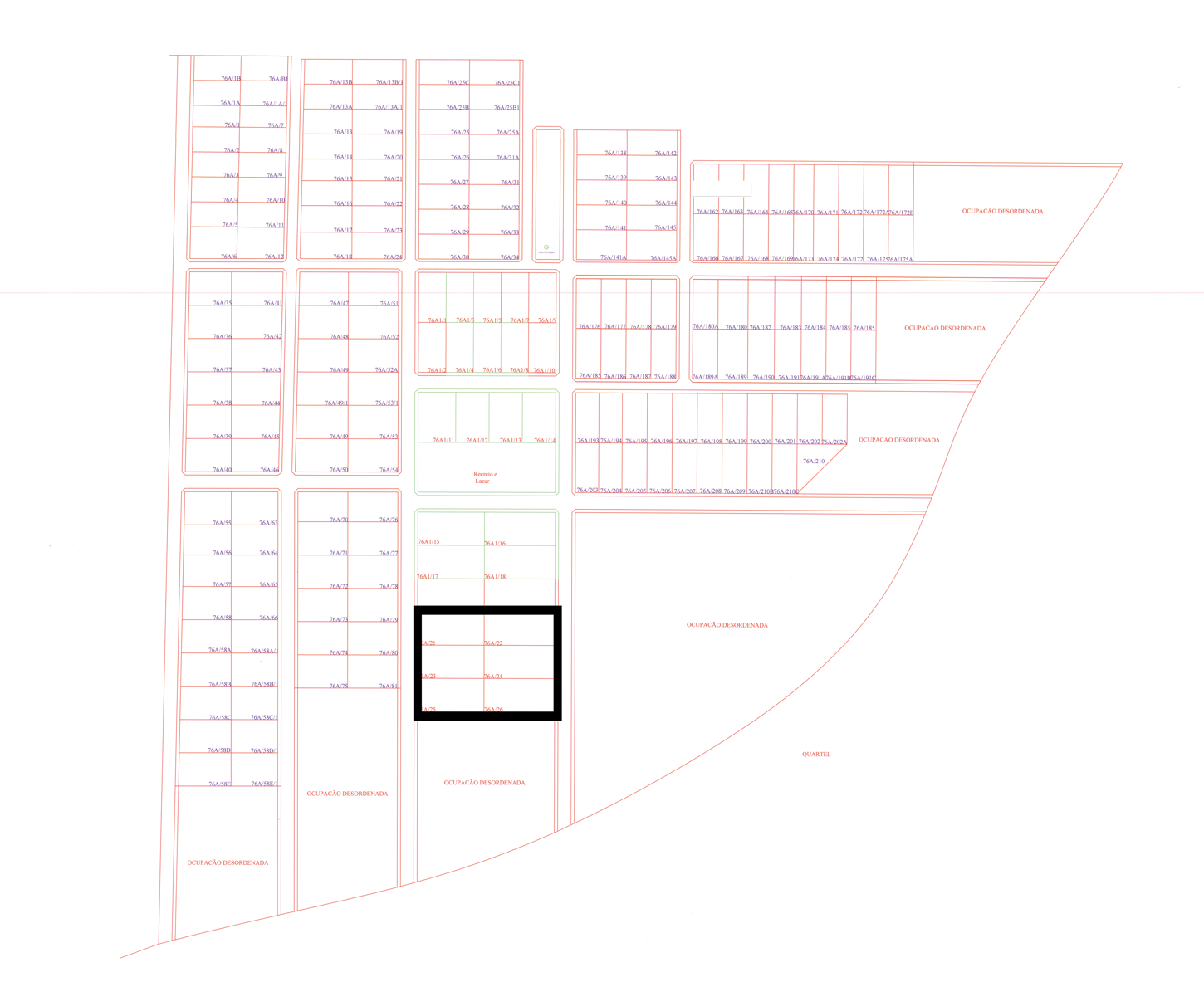
Case 3: Urban farming
Parts of Maputo’s perimeter is composed by a series of adjoining fertile valleys which are being cultivated by a group of farmers’ associations (associações de camponêses). One of these, the Associação Magoanine, was formed in 1988 by Adelino Machaca who has continued as the association’s president ever since. Until recently, the area covered by the association (37 hectares) has been used by members to raise sweet potatoes, cassava and some fruit trees in small cultivated gardens (machambas). During the last 6–8 years, however, the existence of Associação Magoanine has being increasingly threatened by intensified urban sprawl manifesting itself through continuous illegal appropriations along its southern borders. 4 Hence, as an attempt to legalize its assumed claim to legitimate use rights, in 2004 the association submitted an application to the DMCU requesting municipal regularization (i.e. formal parcelling and land titling) of the area. According to the initial request, the Associação Magoanine was already collaborating with the Chinese Embassy on an elaborate US$20 m project of agricultural cultivation which would commence as soon as the regularization was completed. The DMCU responded positively but also made it a condition that the association present the blueprint of the project within a two-year time limit. 5
Meanwhile, Machaca and his associates were also collaborating with an individual DMCU architect whom they had hired informally to draft an urban plan of the 37 hectares covered by the association (see Figure 3). According to Machaca, since the flooding in 2000, the soil had gradually been washed out, which was causing such a drastic decrease of the annual produce that agricultural cultivation would soon lose its profitability. Furthermore, as Machaca reasoned, considering that the area would be converted into housing plots irrespective of their legitimate right to cultivate the land, it was perhaps a better strategy to extract the maximum benefits from the recent development. Machaca explained: The problem is that they [the municipality] wanted to start building here. So we had to do something. The association couldn’t just stop.… Turning this area into a habitational zone was obviously to their [the municipality’s] advantage. So why shouldn’t it be made into a habitational zone which benefits us as well?
The informal blueprint drafted by a DMCU architect for the Associação Magoanine.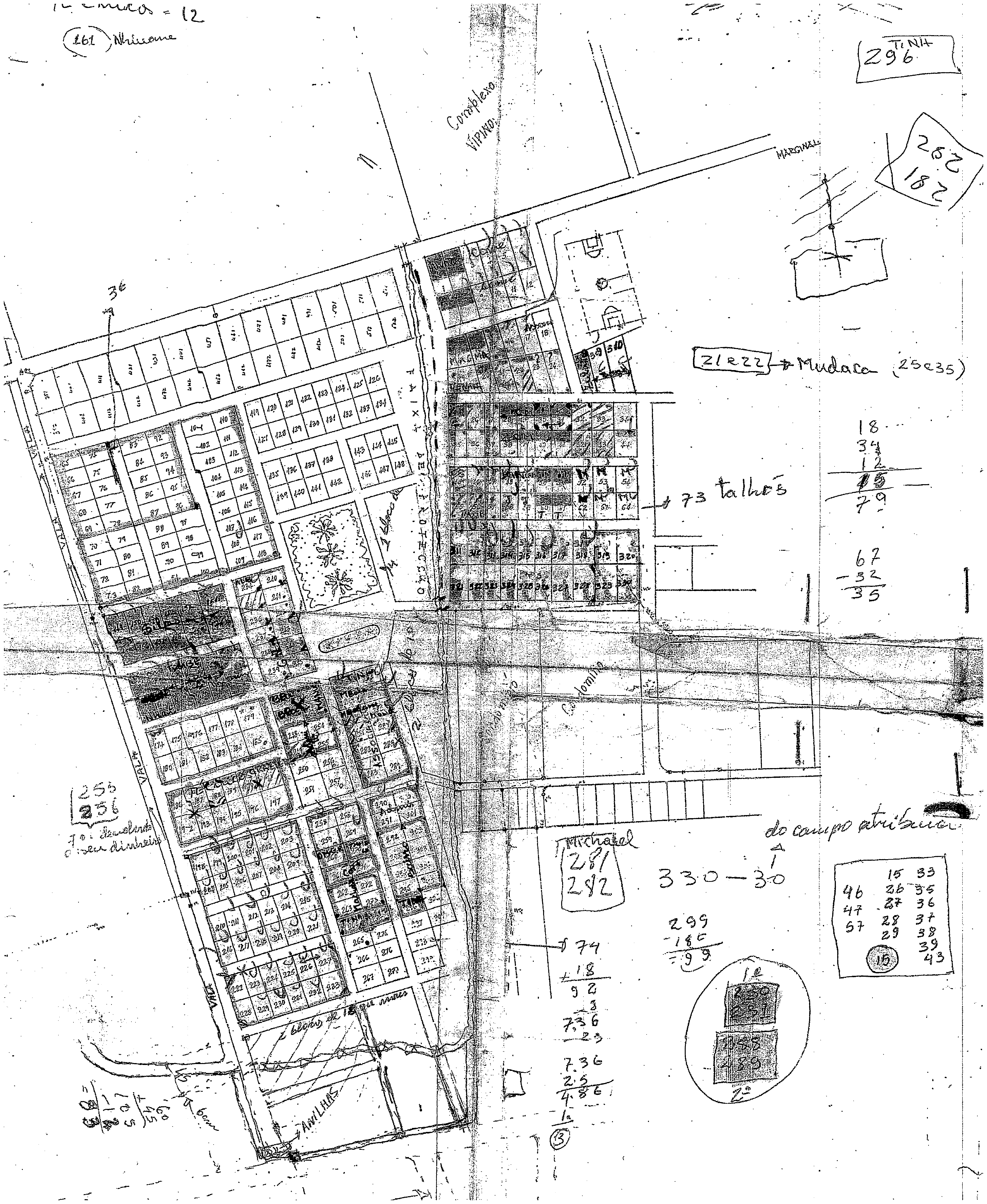
Hence, the strategy of the association was to convert the 37 hectares into a habitational area mimicking the orderliness of surrounding neighbourhoods and sell off individual plots to needy newcomers. The only problem being, of course, that this was completely illegal.
In March 2004, a committee was set up at the Maputo Municipality to investigate the alleged transactions of land by members of the Associação Magoanine. Only four month later, its initial findings were documented in a classified report stating that the association had succeeded in selling 251 15 × 30 metre plots (of which 330 had been parcelled out illegally by DMCU technicians) for 80,000 MZM (US$2895) each. 6 According to the report, members of the association used the blueprint made by the DMCU architect and various official-looking transfer declarations to convince buyers of the legitimacy of the transactions. It concludes by suggesting that Associação Magoanine’s use right to the land be revoked and an internal judicial process commenced against the culprits. This has never been done, however. According to Graça Machava, the district administrator in urban district 3 and one of the members of the municipal committee investigating the crimes, not one of the buyers has been willing to publicly admit that transactions have occurred. As she told me, the illegalities came to the municipality’s attention only because many buyers were influential business people who complained to their political friends about the unfortunate transactions. To be sure, they were less than eager to create a stir about their illegal acquisitions.
In August 2008, the Associação Magoanine was once again the centre of public attention when it was discovered that a Nigerian citizen was building a cement house in the area (Notícias, 2008). He had been unloading construction materials which were clearly not for agricultural activities while also applying for water and electricity installation in a house fronted by an impressive pool and encircled by a 2 metre cement wall. Once again, Machava reiterated the need to revoke the association’s use rights to the land. When I last visited the district administrator, I asked her when she believed the future prospects to be. ‘Well…’ She hesitated for a moment. ‘The building which is already erected [i.e. the Nigerian citizen’s house] needs to be demolished.… And then the area will be regularized.’ I asked if the municipality would use the informal blueprint originally made by the DMCU architect (Figure 3) in a future parcelling process. ‘Yes’, Machava responded. ‘They will use it to parcel out the area.’ At the time of writing this article (January 2011), however, the area is still not regularized and Associação Magoanine continues to operate. 7
The peculiar afterlife of collective ideals
In order to unpack the dynamics of inverse governmentality, the processes described above need to be historically and politically contextualized. In this section, therefore, I outline the recent trajectory of urban governance in Mozambique with a particular emphasis on its ideological connotations. As I shall argue, informal planning practices in peri-urban areas of Maputo actualize dormant spatial ideologies defined by Frelimo immediately after Independence in 1975 which the party itself was incapable of implementing.
Communal villages: Cities born in the forest
During the final phase of colonial rule, the Portuguese forced the regroupment of the African population into aldeamentos (fortified villages). Although initially envisaged as a way of achieving ‘community development’ through the complete monetization of local economies (Negrão, 2002a), the aldeamentos soon turned into a useful strategy for ensuring administrative control and insulating the population from Frelimo’s intense propaganda (Newitt, 1995: 473). According to Henriksen, the result was impressive: 1 million Mozambicans were regrouped in approximately 1000 aldeamentos (1978: 453). Despite the strong Portuguese presence throughout the territory, Frelimo nevertheless managed to control certain areas in the northern regions. While waging a violent war against the colonizers, these so-called ‘liberated zones’ constituted an equally intense combat zone where ideological struggles were fought over how to fast-track an envisioned socialist future (Abrahamsson and Nilsson, 1995: 24–5). According to the party elite, the coming independent nation-state would be guided by ‘scientific socialism’ and it was crucial that the population was prepared and ready for the revolutionary transformations which would catapult the country into a modernist future, liberated from the vices of capitalist-imperialist exploitation. In the liberated zones, Frelimo therefore established a series of ‘bush-based elementary schools’ for Mozambicans supporting the anti-colonial struggle and implemented a communal agricultural system based on collective socialist values (Hall and Young, 1997: 68; West, 2005: 151). After Independence in 1975, Frelimo maintained its emphasis on agricultural production as a societal base with the industry functioning as a ‘dynamizing factor’ (Abrahamsson and Nilsson, 1995: 30). Mozambicans were thus encouraged (and later forced) to move into communal villages (aldeias comunais) in the countryside in order to commence a collective production of crops. During this process, the liberated zones continued to serve an ideological purpose as a ‘strategic politico-moral map’ (Hall and Young, 1997: 54) which spatially indexed how the socialist vision ought to guide life in the communal villages. 8
Of particular importance for the physical-cum-ideological structuring of the aldeais comunais was a manual produced by the Ministry of Public Works and Housing (Ministério das Obras Públicas e Habitação, 1976) and presented at the First National Meeting on Communal Villages in 1976. As argued by the renowned Mozambican architect José Forjaz (2004), the manual was the ‘first widely distributed document made by the state regarding physical planning’ and, during the initial post-Independence period, it came to orient spatial planning practices not just in communal villages but also in rural areas more broadly and in peri-urban zones.
The manual begins with a four-page introduction where the significance of aldeias comunais is explained. Citing president Samora Machel’s speech at the opening of a local Party School, it is stated that: The communal village constitutes the spinal column of the development of the productive rural forces. It is in the communal villages that we unite (congregarmos) the collective forces of the production of the rural masses.… Politically… it is the instrument for the materialization of the Workers’ Power (Poder dos Tralbalhadores) at the level of administrative institutions, defence structures, production, commerce, education, culture, health; in sum, all the sectors of social life.… The creation of a communal village is a task which must be realized with the active participation of the mobilized populations and guided by the structures of the party. (Ministério das Obras Públicas e Habitação, 1976)
According to Júlio Carrilho, former Minister of Public Works and Housing and current professor at the Faculty of Architecture in Maputo, the manual was envisaged as an important tool for the realization of the collective socialist vision. ‘[The communal village] reflected a new human order…’, Carrilho explained in an interview. ‘It established a relationship between the new socialist way of life and the proper territorial order.’ Hence, in the objectivist style of the era, it is stated in the manual that ‘the communal village should be structured so that, little by little, it may correctly develop and provide for its members the satisfaction of a complete life’ (Ministério das Obras Públicas e Habitação, 1976: 4).
Following the outline of the ideological framework, the manual continues with a series of detailed instructions and designs for the physical planning of a communal village. Based on the idea that ‘the communal village is collectively structured on the basis of the Party’s orders’, it is considered crucial to plan the physical environment in order to accommodate ‘mobilizing activities and political studies’ (Ministério das Obras Públicas e Habitação, 1976: 6). Consequently, all neighbourhoods within the aldeia comunal should be located at a similar distance from the communal centre where all political activities occurred (see Figure 4).
Outline of the neighbourhoods within the communal village and their distance to the communal centre.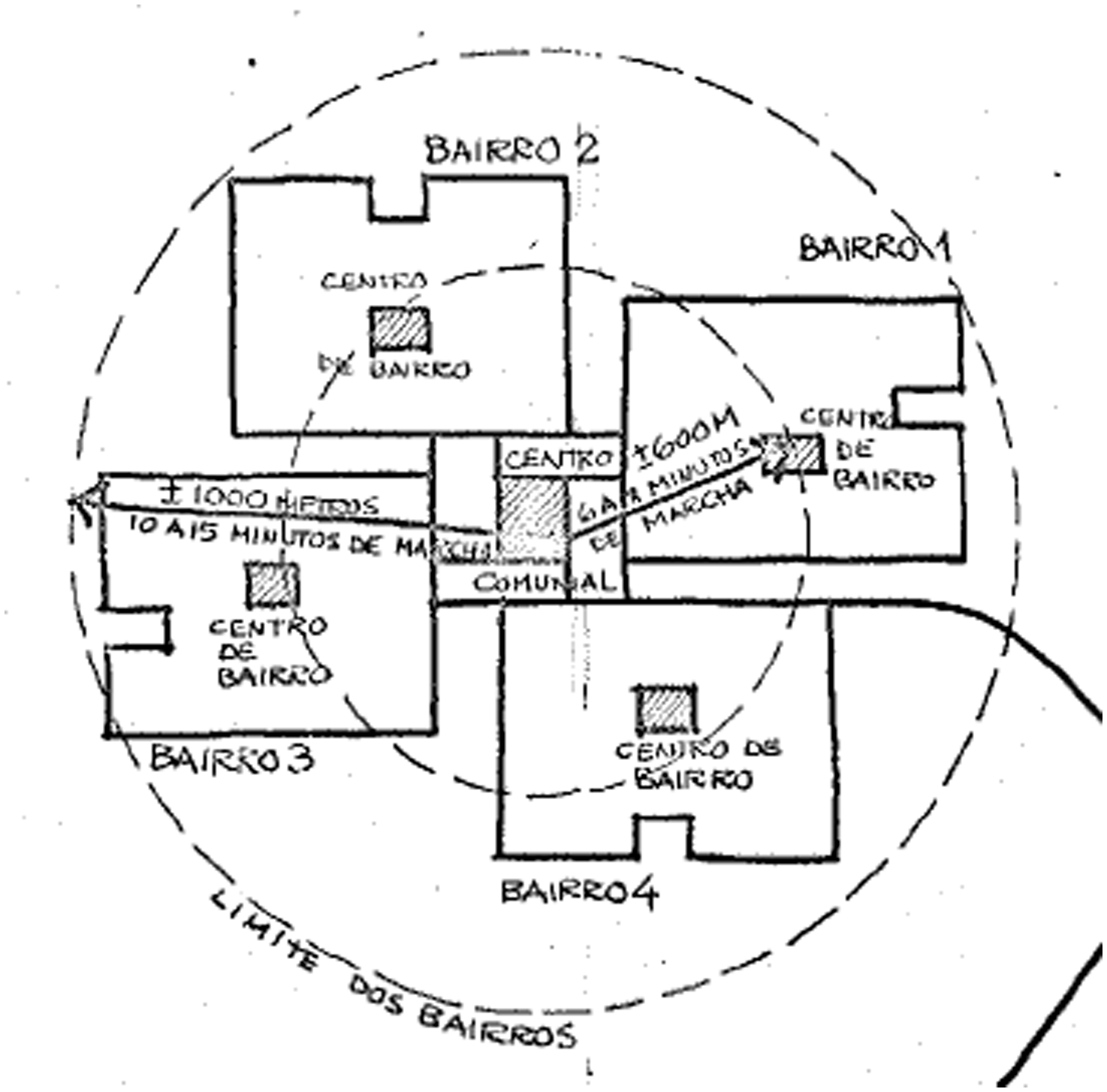
Habitational areas within the communal village were equally structured in accordance with clearly defined collective values. Hence, ‘[a] communal village should be developed so that the different forms of activities necessary for collective life can be realised within it’ (Ministério das Obras Públicas e Habitação, 1976: 4). This required a spatial design separating the communal village into different neighbourhoods, each comprising a maximum of 250 families. Based on this particular organization, it would be possible to secure the ‘full utilization of the installations [i.e. schools and cultural centres] for the members’ collective activities’ (1976: 13). Each neighbourhood was consequently organized as a series of blocks sub-divided into 10–16 individual plots designed to accommodate ‘the necessities of a family’ (1976: 25) (see Figure 5).
A neighbourhood divided into blocks and individual plots.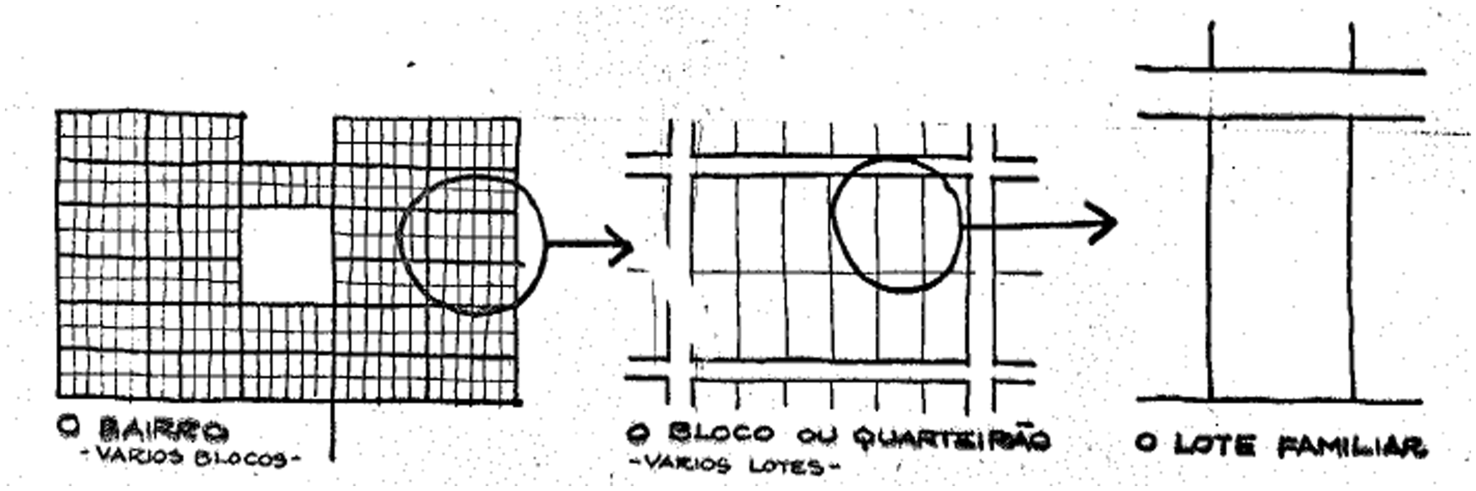
According to the manual, it was not advisable that the size of individual plots exceeded 1200 square metres as smaller plots might benefit the entire communal village by minimizing distances to infrastructural equipment and social activities. In fact, the ideal plot size was considered to be 900 square metres (20 × 45 metres) which made it possible to design blocks of 12 plots and thus secure ‘an efficient and economic usage of public services and collective equipment’ (Ministério das Obras Públicas e Habitação, 1976: 12). Finally, in order to maintain a healthy and ventilated habitational environment, houses should be located 3 metres from plot limits facing towards adjacent plots and the traversing 9 metre wide roads.
Inspired by the Tanzanian ujamaa villagization process, the aldeais comunais were envisaged as ‘cities born in the forest’ (Frelimo, 1976; cf. Roth et al., 1995: 6). 9 As argued by West, the villagization process would thus lead to a fundamental rewriting of the ‘landscape of power in rural Mozambique through the construction of new village-based political and economic institutions’ that would supplant the kin-based authority structures that Frelimo considered ‘“feudal” hierarchies’ (2005: 167–8). With the launch of Operation Production (Operação Produção) in 1983, the modernist impulse was further intensified. In an attempt to realize the productive potentials of hitherto ‘parasitic urban dwellers’, more than 50,000 people from Maputo were forcibly resettled to rural areas (Jenkins, 2006: 116). Through hard labour, they would be transformed into ‘useful elements of society, honest workers, citizens who fulfil their civic duties… worthy of being accepted into society’ (2006: 116). It was soon apparent, however, that the objective of transforming all aspects of social life in accordance with Frelimo’s modernist vision was harder to achieve than anticipated. The party cadres in charge of the agricultural production units lacked the technical skills to operate the machinery and were often incapable of gaining the confidence of villagers accustomed to the kin-based authority structures of their former settlements. Despite the explicit encouragement to focus on the production of collective crops, residents in many communal villages therefore continued to cultivate their own land elsewhere and so productive and collective outcomes continued to be relatively minimal. Although initially projected for 6 million Mozambicans, only 1.6 million ended up living in aldeais comunais, which the Ministry of Agriculture admitted had not made a profit (Hanlon, 1984: 101). We might thus concur with Ottaway (1988: 216), who argues that communal villages were not, in fact, communal as they affected only 10 percent of the population.
Auto-construction as urban ideal
Whereas the planning ideals for the communal villages did not have the intended effects on agricultural production, they did, however, influence later approaches to physical planning in urban areas. According to Júlio Carrilho, immediately after Independence in 1975, the Frelimo government realized that housing conditions for the growing urban population could not be improved through state-orchestrated activities alone. The exodus of nearly all Portuguese officials had left the state administration in a shambles and without the necessary human and technical capacities to carry out even smaller planning initiatives (Grest, 1995: 153). At Frelimo’s Third Party Congress in 1977, it was consequently announced that ‘the principle of people relying on their own efforts must be established for the improvement of housing conditions in the current period of shortage of resources and capacities’ (Frelimo, 1977 in Jenkins, 1998). ‘Participation was a hot topic in that era… having people build their own houses,’ Carrilho explained in an interview. ‘We called it assisted auto-construction [auto-construção assistida]…. We already knew about auto-construction from Brazil and UN-funded programmes so we thought that it might be interesting to establish a programme rooted in popular participation here.’ 10 With support from the United Nations, a sites and service programme with an accompanying self-help housing assistance programme was thus initiated in Maputo in 1976 (Jenkins, 1999a: 12) and during the next decades urban planning departments came to rely increasingly on popular participation for providing housing for the growing number of citizens seeking opportunities and shelter in the city.
It was the weaknesses of the administrative system – and not adherence to socialist values – which allowed for the continued importance of self-help schemes guided by planning ideals for communal villages. These weaknesses were particularly aggravated from the late 1980s, when Mozambique made its ‘turn towards the West’ and agreed to implement a series of IMF-sponsored structural adjustment programmes (Devereux and Palmero, 1999: 3). At the time, the country had been brought to its knees after a severe 14-year civil war between Frelimo and Renamo, 11 and when Mozambique was then hit by the worst drought in decades, the need for urgent aid was evident. In order to give its financial support, however, the IMF made it a condition that government spending be drastically reduced, so salaries were cut by two-thirds (Hanlon, 2002: 7). As a consequence, civil servants, including architects and land surveyors, began to moonlight in order to secure a viable level of subsistence for themselves. Today, the effects of a weak state apparatus are apparent everywhere: dilapidated public buildings occupied by civil servants without the necessary qualifications manage a state administration that is incapable of carrying out even the simplest tasks and services (Nielsen, 2007a). Illicit activities are endemic in all sectors, to such an extent that we might speak of an ‘inversion of values’, as it is frequently considered immoral not to steal from the state (Hanlon, 1996: 2).
Urban management in Maputo is a particularly salient reflection of this development. Despite rapid population growth in the years following independence, the colonial neglect of the urban population was reproduced. Of all 86,300 houses build from 1980 to 1997, only 7 percent were supplied by state or private sector agencies, whereas the remaining 80,000 plus houses were built as ‘self-help’ constructions, mostly without assistance from state or municipality (Jenkins, 1999b: 23–4). Without a functional urban governance system, people have nevertheless found alternative ways of accessing land. According to Jenkins, 75 percent of all access to land occurs informally, that is, through local leaders or civil servants illegally parcelling out plots, which are later informally sold (2000a: 145, 2000b: 214). When it comes to a lack of capacities for urban administration, the DMCU is the locus par excellence. Since its creation in 1980, the DMCU has been responsible for urban planning, including the demarcation, allocation and registration of land (Boucher et al., 1995: 12). However, from its inception, the stable functioning of the institution has been hampered by a lack of capacities and political neglect. The DMCU was originally created only for the small city centre, not for the expanding peri-urban areas that also fall within the municipal limits. As Senda, the former chief of the urbanization department told me: ‘The DMCU was designed for a city which is no longer Maputo.’ This goes not only for the layout of the city, but equally for the human resources. Currently, ten civil servants within the institution have a university degree, and of the total technical staff of approximately a hundred employees, 75 percent have finished only secondary school (Carrilho et al., 2005: 5). These surveyors and architects work with a land cadastre which has not been updated since 1985 (Jenkins, 2001: 637). The absurdity of the current situation is apparent in Garvey’s (1998) estimate that it would take approximately 120 years to survey and title the Mozambican national territory.
According to current Mozambican legislation on land (República de Mocambique, 2004), specific urban plans are integral parts of a hierarchical system of plans, ranging from national planning devices to the Detail Plans (Planos de Pormenor) which ‘define in detail the occupational typology of any specific area in the urban centre’ (Art. 10). These different devices outline in detail all aspects of urban and rural territorial planning, ranging from infrastructure and road systems to potential industrial zones and habitational areas. Parcelling-out (parcelamento) is, in a sense, the simplest planning instrument available. To parcel out a plot is at the same time to transform the urban landscape and must therefore occur in accordance with the planning devices created for the particular context. The only problem is that these legal devices do not have practical relevance. With an urban administration which lacks sufficient financial and human capacities, actual planning practices are rarely anchored in any broad-ranging juridical framework. ‘If you’re looking for a legal document, you won’t find it,’ Sambo, an architect at the DMCU assured me. But that doesn’t complicate anything because everyone knows that’s how it works … We have to go around things [dobrar]. Often, we are confronted by a situation out of the ordinary where we have to depend on our creativity. If we had to wait for a legal instrument, we would immediately come to a standstill.
As Senda, the former head of the urbanization department at the DMCU poignantly put it, urban management is, in fact, ‘administration ad hoc [gestão ad hoc]’, functioning simply to secure ‘a minimum of urban order’ (cf. Kamete and Lindell, 2010).
Bearing in mind the weak administrative capacities at state and municipal levels, it is perhaps no surprise that urban governance was inversely realized, so to speak, in all the above-mentioned cases. Although the DMCU was officially responsible for administrating land use, the actual realization of urban governance was carried out by residents occupying land illegally. When Boavida Sîtoe requested regularization of the informal settlement from the DMCU (Case 1), he was repeatedly given the response that no official action would be taken unless a project (i.e. an urban plan) was presented. If an urban plan was outlined by an agent outside the municipality, it would most likely be approved. Zamir, the architect drafting the urban plan, explained the logics of peri-urban planning. ‘The moment the municipality receives a project which they didn’t have the capacities to make themselves, they will approve it.… So we gave this project to the municipality. Now, they just need to implement it.’
If we take into account the historical trajectory of land management since Independence, however, the dynamics of peri-urban planning might be elaborated further. According to Júlio Carrilho, current housing and parcelling practices in peri-urban areas of Maputo need to be seen in relation to the initial post-Independence aspirations of establishing a physical environment based on socialist and collective ideals: The political line laid down at the 8th Session of Frelimo’s Central Committee in 1976 regarding the political and economic organization of the communal villages and the territorial organization of the country has continued until today. It has been the only possible way for people to organize and make individual plots.… So the debate on plots started with the communal villages and their plots on 45 × 40 metres and then later they used the ideas for parcelling in Maputo…
Today, these ‘ideas regarding parcelling’ are used by residents in peri-urban areas of Maputo who parcel out 15 × 30 metre plots. Although the current juridical status of this planning standard remains unclear, 12 most architects and land surveyors from the DMCU agree that 15 × 30 metres is the appropriate size for plots in peri-urban areas and, equally important, the only viable medium for potentially attaining property rights to land. Following Carrilho, I will consequently argue that peri-urban planning schemes on illegally occupied land, such as those described in the three cases above, derive their legitimacy by resuscitating spatial ideals emerging during the initial post-Independence era and which the state was incapable of implementing. In a very concrete sense, the homogeneous design embellishes what the Frelimo state could have done; or rather, what it ought to have done, given sufficient human and financial capacities. As we saw above, the elicitation of idealized urban standards through processes of informal parcelling has created a peculiar reversal of the relationship between planning rationalities and the formalization of existing occupations. In all three cases, the urban plans used to parcel out land were subsequently appropriated by the DMCU as formal planning tools in accordance with which current residents were allocated use rights to land. We might therefore argue that the lack of legalization notwithstanding, given that residents build as if they were realizing urban standards, they came to create the latter.
If we were to analyse current land policies in peri-urban areas of Maputo, Mozambique, using a conventional governmentality approach, we would obviously need to examine the techniques and procedures through which political rationalities come to orient and regulate the actions of free individuals (Foucault, 1980: 125). All forms of governance carry (implicitly or explicitly) aspirations of shaping human conduct towards certain ends and this makes their analysis a matter of determining ‘what authorities of various sorts wanted to happen, in relation to problems defined how, in pursuit of what objectives, through what strategies and techniques’ (Rose, 1999: 20). From this perspective, it is relevant to analyse the ways in which neoliberal rationalities couched as structural adjustment programmes have gradually come to orient Mozambique’s national policies on land and, particularly, the overt emphasis on private property rights as a condition for stable economic growth (World Bank, 2003; cf. Negrão, 2002b). All three cases might thus be read as accounts of the social technologies by which residents in Maputo calibrate their lives in accordance with broader socio-economic rationalities, for example by physically structuring their environment to accommodate a commoditization of land. Consequently, the Mozambican state appears to operate entirely as proxy for international lending institutions whose strict conditionalities on public expenditure may be held responsible for the country’s current weaknesses.
I wish to suggest, however, that a more dynamic analysis of peri-urban planning in Maputo may be achieved by inverting the relationship between governance and population. Without disregarding Foucault’s succinct argument that to govern is ‘to structure the possible field of action of others’ as a ‘conduct of conduct’ (1982: 221; cf. Rose, 1999: 19–21), we need to consider a form of popular reason that takes as its object the problem of governance rather than vice versa. Thus, I argue that all three cases described above reflect how a particular form of governance was elicited by actualizing dormant collective ideals, which differs significantly from formal governance and its associated political rationalities. As described above, formal approaches to urban land might be taken to constitute a set of governmental technologies aiming at the individualization and commoditization of land. Through concrete programmes, for example campaigns on using private property as collateral for obtaining bank loans, it inscribes individual Mozambicans within a broader political rationality regarding proper economic conduct. It is through these same procedures, however, that a parallel form of governance emerges that is oriented towards the political regime rather than the population. It asserts itself not as the dynamic regulation of a heterogeneous domain outside the realm of the state but, rather, as a relatively homogeneous model for governance guided by collective ideals. Given the current weaknesses of the Mozambican state, it has been possible to feed this model back into the formal governance system and subsequently allow it to operate as a basis for urban planning. In this regard, inverse governmentality might be defined as the popular and coordinated attempts at producing governmental techniques and regulations by which to be governed. This reading of the relationship between governance and population furthermore allows for a more nuanced understanding of the state in Mozambique. Rather than functioning merely as a technology put to use by broader economic rationalities, the Mozambican state appears as a locus for the production of popular desires and imageries of what governance should be like and how it might open towards new ways of making sense of the environment, devising ways of improvement and ways of achieving these ends (Rose et al., 2006: 99).
The functioning failures of peri-urban planning
Having thus outlined the recent history of peri-urban planning and how it resuscitates dormant planning ideals, I will now proceed to examine the peculiar effects of inverse governmentality for residents in the three areas before concluding with a broader discussion of urban planning and governance.
Aesthetics and repetition
‘You can’t built anything unless the area has been urbanized (urbanizada); that is, unless it has been properly organized.’ I had asked Adelino Machaca, the president of the Associação Magoanine (case 3) why the parcelling of the area was so important and he replied without hesitation: ‘From the moment we wish to construct houses, there have to be roads.’ To be sure, all three process of land parcelling convey a meticulous attention to urban aesthetics. As Munguambe, one of the members of the informal committee responsible for parcelling out the commercial zone (case 2) told me when asked about the preference for 15 × 30 metre plots: ‘We liked (gostar) using 15 × 30 metres because it is the norm for a land plot. The official norm for a plot of land here in Mozambique is 15 × 30 metres.’ Although Munguambe is undoubtedly right when claiming that 15 × 30 metres is a widely used norm for informal land parcelling, it is not correct that it is an officially sanctioned standard. Through the repeated and illicit parcelling processes occurring in peri-urban areas of the city during the last three decades, a unique spatial regularity has nevertheless emerged which provisionally structures urban governance. 13 Although it seems to manifest itself as repetitions made from the same template, no overarching planning policy guides the practical management of urban land and so individual parcelling processes reproduce an original which currently exists only through its many scattered imitations. Paraphrasing Strathern, we might argue that the spatial aesthetics which is being produced through processes of inverse governmentality is ‘an original and a derivative at the same time’ (2005: 148). While it might seem a counter-intuitive idea, the originality emerges through repetitive imitations of a non-existent original. What is repeated, then, is not the same but governance as a differentiating idea which is revealed through the physical materiality of parcelled-out plots.
Partial visibility
It was during my conversation with Ismail Zamir, the architect who drafted the urban plan for the informal settlement near the coast (case 1), that I came to understand how certain subject positions might be inversely created through processes of peri-urban planning. According to the 1997 Land Law, residents can only commence building projects with durable materials provided they have provisional use rights to a plot (Art. 20). However, as Zamir told me, in several instances, informal residents acquire pragmatic use rights because they build houses with durable materials. In other words, illicit building activities lead to the acquisition of those rights which (ideally) enable residents to carry out the former. A few days after my conversation with Zamir, I spoke with Sambo, a DMCU architect, in order to corroborate Zamir’s peculiar description. As he made abundantly clear, regardless of its potential illegality, when a building project has commenced, it remains there. ‘We are a poor country,’ Sambo said with a smile. ‘Therefore, it doesn’t make much sense to remove a house which could easily stay there.’ I asked if the reason for accepting illegal housing was a lack of financial means. ‘Exactly!’ Sambo nodded eagerly. ‘There are no means.’ 14
Following Ferguson (2006: 157), we might argue that these processes reflect a form of alterity that refuses to be other. Rather than distancing itself from the locus of power, it seeks to be recognized by it, given the imagined affordances emanating from such a position (Nielsen, 2009). It is nevertheless a partial visibility which is produced through informal building projects. As I have emphasized above, by erecting houses which convey a homogeneous urban aesthetics, residents are not merely copying current forms of governance; they become the governing force. Still, by producing the gaze of power by which they ought to be illuminated (e.g. by making urban plans which state and municipality subsequently use as tools for official urban management), residents equally establish a productive distance from otherwise malevolent agents, such as greedy civil servants attempting to appropriate their land. Recalling Sambo’s statement that informal occupation is pragmatically legitimized when people build cement houses, it is also an indication that further involvement with official agencies may be avoided. Whereas residents in reed-huts are frequently being inspected and even removed with force, residents in cement houses rarely endure similar treatment – irrespective of the illegality being the same. We might perhaps argue, then, that acts of inverse governmentality produce subject positions which are characterized as much by difference as by similarity (cf. Taussig, 1993: 129–30). When residents have their plot parcelled out and subsequently commence building projects, they will most likely be able to maintain a proper distance from those state agencies that might otherwise deflect a set course towards a completed cement house (Nielsen, 2010). 15
How man makes governance
In her insightful article ‘How man makes god in West Africa (1981), 16 Karin Barber shows how the West African Yoruba people make the òrìsà (‘gods’) by being their devotees. Relationships between god and devotees are in fact magnified images of the relationship between big men and their followers. The scope of a big man’s political power in Yoruba society depends on his followers, whose attention and acknowledgement can make it bigger or smaller (1981: 736). In an analogous manner, the òrìsà depend on the worship of devotees, without which they would cease to exist. As Barber tells us: ‘[i]f no-one supports a Big Man any more, he loses his power; if devotees abandon their òrìsà, it falls into oblivion’ (1981: 740).
In peri-urban areas of Maputo, people create the power of governance through processes of land parcelling with the same zeal as Yoruba devotees make their gods through worship. According to local residents, they inhabit a partially visible universe composed of ambiguous and potentially malignant forces which must be controlled in order to secure stable social positions (Nielsen, 2008: 115–30). Governance is consequently the ability to create a momentary balance between these forces and thereby improve one’s room for manoeuvre (cf. Corsín Jiménez, 2008: 180). Without a doubt, the predominant ‘force’ to be dealt with by residents in these areas is the threat of losing their land and, to be sure, this is no simple feat. Not only are political agendas on land impossible to decipher (not least because of their partial or absent overall logic), a threat may materialize suddenly and unexpectedly. As previously emphasized, even when individual building projects reflect some kind of urban aesthetics, residents’ occupancy is still only pragmatically secured. 17 In February 2009, civil servants from the DMCU informed residents in the northern sector of the informal settlement near the coast (Case 1) that their plots would be expropriated and used for a building project in the neighbouring area. Although the civil servants probably acted on their own, it was impossible for the residents to know whether the threat was real or not. In this unstable socio-political environment, then, it is through acts of inverse governmentality that a topology of power is created which potentially minimizes the threats against residents’ informal occupancy of land. By creatively seeking to respond to the problems caused by weak governance structures, residents make the locus of power which legitimizes their actions. If, as Rose argues, to govern is ‘to be condemned to seek an authority for one’s authority’ (1999: 27), then to govern inversely is to create the authority for one’s authority and subsequently allow it to condition one’s conduct.
Intersecting legalities of urban governance
Let me finally conclude by comparing the findings above with the ‘making’ of urban governance elsewhere in sub-Saharan Africa and Latin America. As we shall see, whereas the informalization of urban planning in Maputo is comparable with other urban situations, the balancing of the tense relationship between governor and governed through imitations of planning ideals seems to be particularly pronounced in Mozambique.
Many independent nation-states in sub-Saharan Africa inherited what were essentially outdated colonial administrations and, without the financial and human capacities (let alone political will), it has been impossible to implement uniform governance systems (Briggs and Yeboah, 2001: 23). To take an apt example, customary land rights systems continue to condition access to land in Dar es Salaam, which has basically been built on informally sub-divided land (Gough and Yankson, 2000: 2489). Similarly, it is through spontaneous settlements that Bamako, Mali’s capital, continues to expand (van Westen, 1990). As noted by van Westen, this does not ipso facto imply increasing conflicts over land rights. Although all tenure practices in Bamako’s spontaneous settlements are illegal, ‘customary ideas about tenure are usually scrupulously complied with’ (1990: 97).
Consider, for purposes of comparison, how land is accessed in Bogotá, Columbia’s capital. According to Gilbert and Ward, the majority of the urban poor acquire land through illegal subdivisions, what is locally known as ‘pirate urbanization’ (1985: 80ff). 18 Without the necessary public means to implement comprehensive planning initiatives, pirate urbanization has proven to be a viable strategy for securing land. Although neither equitable nor efficient, it is therefore accepted by officials and residents alike. Still, the stable functioning of the system cannot be assumed to continue without the careful control of the state and, for this reason, a series of regulations and decrees have been implemented which seek to restrict the growth of new pirate urbanizations and to provide services for already existing areas. 19 Residents on informal land have thus been able to upgrade and ultimately legalize their plots, and thereby achieve status as formal citizens. As Scott tells us, state officials often come to ‘tolerate, if not condone, a host of informal practices that in fact underwr[i]te the survival of the official scheme’ (1998: 310). This is particularly salient in Mexico City, where illegal land invasions have been accepted by the government as a means of maintaining political stability (Varley, 1998). When Carlos Salinas was still presidential candidate for PRI (Partido Revolutionário Institucional), he implemented an ambitious urbanization plan through which more than 2.1 million plots of land were regularized. The immediate political effects of the manoeuvre could be read at the next Congressional elections, where the PRI won easily, with the majority of voters being registered among the lower classes. Varley thus concludes that ‘regularization was an extremely useful tool with which to woo the urban poor’ (1998: 181). For the present discussion, however, the most interesting contribution from Latin America is perhaps James Holston’s careful analyses of what is locally known as ‘auto-construction’ (auto-construção) on the outskirts of São Paulo (1991, 1999, 2008). Auto-construction refers to the house-building activities of the urban poor during the last five decades of rampant urban sprawl. With the rapid influx of poor migrants starting in the 1940s, the Brazilian state encouraged a shift of the land market from rent to ownership (Holston, 1991: 449). This socio-political change eventually pushed residents living in rental units out of the city whereby a spatial and class-based dichotomy was established between centre and periphery. Despite the spatial segregation, however, residents on the fringes of the city continue to built houses based on aesthetic evaluations of proper middle-class housing standards and through these processes, new forms of urban citizenship have erupted which potentially unsettle existing forms of domination (Holston, 2008: 263).
When considering these heterogeneous processes of urban governance, it seems apparent that ‘[t]here is nothing about building or inhabiting a house which fails to comply with planning regulations to turn the builder into a criminal’ (Perdomo and Bolívar, 1998: 124). Surely, in all examples described above, the illegality of urban occupations is a flexible category that is continuously being contested and reversed. What distinguishes the processes of inverse governmentality in Maputo, however, is the particular configuration of the relationship between state and informal residents. I will argue that in all the examples described above, the state has an exterior position, as it were, marked by a (relatively) clear distance between systems of governance and informal occupations. As we have seen in Maputo, however, this relational exteriority cannot always be upheld. Current forms of formal governance in peri-urban areas derive their force and aesthetics from processes of informal parcelling authored by residents who occupy land illegally. It is consequently when appropriating the imitations of its own idealized past that the governing powers of the state gain momentum. Finally, without clearly demarcated oppositions, overt disputes between state and informal residents are rare. In a very concrete sense, all parties involved are guided by similar aesthetic and pragmatic imageries of governance whose inverse trajectory points from parcelled-out plots towards the administrative structures of state and municipality.
Conclusion
In ‘People as infrastructure’ (2004), Simone offers a novel reading of urban African socialities. Although acknowledging the failures of African cities in providing consistent territorial organizations capable of controlling the diversity of activities occurring within their domains, we do not, Simone tells us, need to see processes of urbanization in Africa as being somehow chaotically incomplete (2004: 409). In fact, when calibrating our exterior gaze to the minuscule and uncertain everyday encounters of urban residents, a regularity can be discerned which emanates from the widespread need to engage in open-ended and flexible reciprocal interactions. Through this fine-meshed and flexible interactional system of reciprocal encounters and interactions, urban African residents come to experience ‘new forms of solidarity through their participation in make-shift, ephemeral ways of being social’ (2004: 426).
In Maputo, a similar form of regularity has emerged through informal residents’ attempts to ‘make’ peri-urban governance. Although loosely knit, it has created interdependencies between residents trying to stay out of each other’s way. As I have indicated throughout this article, this emerging regularity may fruitfully be seen as a unique form of inverse governmentality which has come to condition people’s social-cum-spatial dispositions and everyday interactions. When considering urbanization processes such as those described in the case studies above, it is clear that socio-political regularity does not derive entirely from strategically focused instantiations of urban governance aiming to orchestrate the codification of social multiplicities. Through people’s struggles to balance those counteracting forces in the universe which constantly threaten to paralyse prospective actions, such as house-building, an inverse kind of governance emerges which stretches out from individual acts to establish broader configurations of power. Rather than the city being somehow read through particular schemes of power, the city consequently reads itself.
With the notion of inverse governmentality, it is possible to engage critically with Foucault’s widely known approach to power. According to Foucault, power relations, such as those coming together as configurations of governmentality, are established between positions which are fundamentally exterior to each other; hence the notion ‘conduct of conduct’ (Foucault, 1982: 220–1; see also Burchell, 1996: 30; Deleuze, 2006: 72). Throughout his writings, Foucault is careful to show that although it is impossible to find a central point from where power emanates, human conduct tends to be directed by calculated means as if under the authority of a guide (Foucault, 1982: 217; 1997: 68; cf. Ferguson and Gupta, 2002: 989). If, however, we take power to operate inversely, as it were, this image of exteriority cannot be upheld. As we have seen in the three case studies, the making of authority (e.g. the legitimizing power which arises when implementing urban plans without juridical basis) is an outcome of residents’ efforts to balance potentially malignant forces in the surrounding universe. Distances between different positions – the relations of exteriority, if you like, are laid out through individual acts of inverse governmentality as a particular aesthetics of power. What the different positions might be and how they relate to each other is, in other words, an effect of inverse governmentality and not its precondition. Whereas Foucauldian power analytics emphasize the intricate ways that praxis is penetrated by manifold forms of domination (Foucault, 1998: 99–100; Rose and Miller, 1992: 183), the idea of inverse governmentality suggests that power equally likely operates as eversions of particular aesthetic forms (e.g. the structuring of urban land and individual subject positions according to the same logic of distance), which come to constitute immediate configurations of governance.
To privileged groups of informal residents, the regularity which emerges through acts of inverse governmentality may serve as a viable platform for their engagements with an uncertain future in a politically volatile environment. As I have described above, by drafting and implementing (illicit) urban plans, people make the governing powers which condition their everyday interactions. Although acts of inverse governmentality do not constitute the coming into being of new democratic ideals, they do indicate the flexible and mobile ways that structures of power may come to function also to the benefit of marginalized people living on the fringes of the city in sub-Saharan Africa.