
Abstract
International fast food franchises, such as McDonald’s and Domino’s Pizza, have become vital arbiters of security in postwar Guatemala City. They map red zones with a moral authority that even the National Police cannot match. Red zones, or zonas rojas, are neighborhoods in Guatemala City deeply affected by gang- and drug-related violence. While the National Police map these zones by documenting the location of committed crimes, international fast food franchises produce delivery maps that assess the quality of transit through the city. International fast food franchises worry less about the relative security of a given address than about their drivers’ ability to travel safely from their restaurant to the customer’s address. This article, in response, assesses this mobility as a constituent dimension of security in Guatemala City while also detailing its effects. One effect is the affective fallout of being denied a home delivery and becoming what this article calls “disenfranchised.”
“I live in a red zone,” Maria confessed as her young child played in her arms. 1 A red zone, or zona roja, is a neighborhood in Guatemala City deeply affected by gang- and drug-related violence, where security can feel dubious at best. Guatemala City, by all accounts, is riddled with red zones. With homicide rates as high as 40 times the U.S. average and conviction rates for those homicides as low as 3%, Guatemala City is routinely ranked one of the world’s most dangerous cities (Dudley, 2016). Two decades of social scientific research, in fact, detail how unprecedented levels of urban violence affect the spatial organization of Latin American cities, documenting the many ways in which violent crime segregates communities along brutal divides (Angotti, 2013; Caldeira, 1996; Goldstein, 2004; Valenzuela, 2005; Wacquant, 2008). In Guatemala City, the divide is between red zones and everywhere else. Fully aware that there is no real consensus on which parts of Guatemala City are red and which are not, I pressed Maria on how she knew that she lived in a red zone. She did not have to think twice. “I ordered a pizza,” she quipped.
International fast food franchises have become vital arbiters of security in Guatemala City. Amid the retreat of state services (O’Neill and Thomas, 2011) and the rise of global capitalism (Fischer and Benson, 2006) in Guatemala, international fast food franchises, such as McDonald’s and Domino’s Pizza, map Guatemala City’s red zones through the practice of home delivery (servicio a domicilio). Pitched as a customer service, home delivery offsets the risk of customers becoming the victims of violent crime while walking the streets, taking the bus, and driving through traffic with their hard-earned purchases (Figure 1). The service has become so popular that it has yielded at least one rather upbeat advertisement: Walmart, la tienda que está en todos lados (“Walmart, the store that is everywhere”). The problem, however, is that these franchises cannot be everywhere. The urban violence that makes home delivery so important is the very violence that precludes companies from delivering to every address. As a result, international fast food franchises take it upon themselves to map red zones and then fastidiously avoid them.
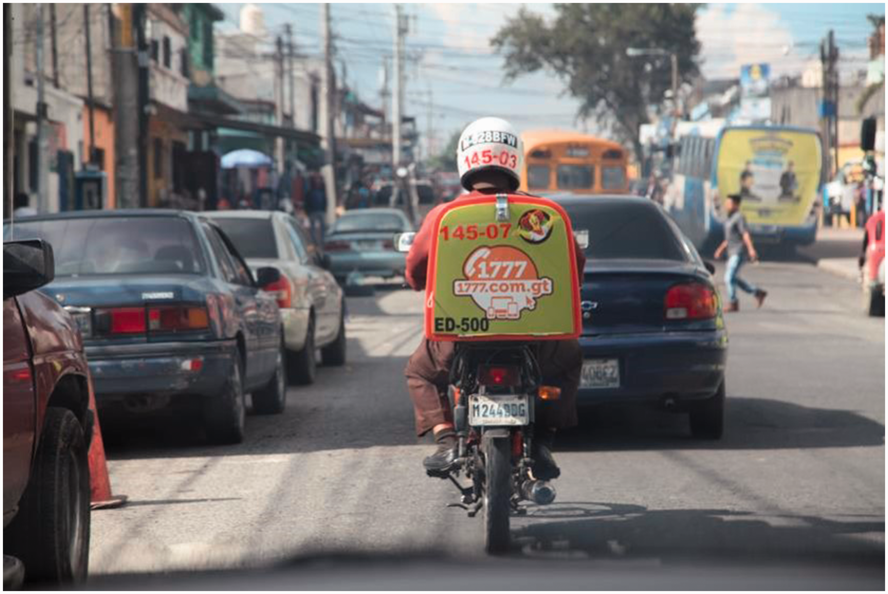
Delivery, main road (2017). Photograph by Benjamin Fogarty-Valenzuela.
This article, in response, details the mapping practices of three international fast food franchises in Guatemala City. They are Domino’s Pizza, McDonald’s, and Pollo Campero. The latter is a Guatemalan fried chicken franchise with 64 restaurants in Guatemala City as well as dozens of outposts in the United States. Extended fieldwork with store managers, call center workers, delivery personnel, and longtime customers allowed for an in-depth study of when and why each of these franchises accepted or rejected a home delivery assignment in the specific site of this study: Zone 18. This is the largest and most violent of Guatemala City’s 22 zones, with twice the number of homicides compared to the city’s next most violent zone: Zone 6 (Castañón, 2011). More significant than any kind of consensus over whether a particular address was indeed red or not were those moments of debate between customers and delivery personnel over what constituted a red zone and what signified a secure part of Zone 18.
Three ethnographic facts emerged from this research. The first is that a concern for mobility organizes the mapping practices of international fast food franchises in Guatemala City. These franchises are not concerned with the perceived security of a given address so much as a driver’s ability to travel safely from the restaurant to the address. “The house can be really nice,” explained one driver for McDonald’s, “It can be in a really safe enclave (residencial) with big walls (muros gigantes) and armed guards (guardias armados), but if I can’t get there safely, then it’s a red zone.” The second fact is that this concern for mobility turns the mapping of red zones into an extended conversation about choke points (puntos), potholes (hoyos), alleyways (callejones), and such geological formations as canyons (barrancos) and blind spots (puntos ciegos). “El Prado is a beautiful neighborhood,” explained one driver for Domino’s Pizza, “but you need to travel through La Maya to get there. La Maya is dangerous [in part because] there are so many blind spots.” The third fact is that these delivery maps provide an astoundingly nuanced and morally authoritative understanding of red zones in Guatemala City. As frustrated and offended as Maria might have been to learn that her neighborhood was a red zone, the delivery map that announced her neighborhood’s redness proved to be hegemonic.
These three ethnographic facts ultimately invite scholars to consider mobility as a constituent dimension of security in the Americas. By mobility, this article means sites of transit and passage, such as roadways and alleyways (Adey, 2010; Brenner et al., 2010; Cresswell, 2010; Kesselring, 2006; Sheller and Urry 2006). In contrast, the study of security in the Americas has long focused on the built form, namely the fortification of homes (Brown, 2010) and enclaves (Caldeira, 2001; Low, 2003). Charting extensive landscapes of self-protection, scholars over the last three decades have detailed the proliferation of chain-link fences and razor wire in ways that advance a rather static image of citizens bunkering down behind an expanding complex of walls (Graham, 2010; Mitchell, 2003). Yet a so-far-uncoordinated generation of scholars has begun to augment this observation by recognizing the centrality of mobility to the practice of security (Leese and Wittendorp, 2017). This has meant detailing the circulation of people and goods between fortified locales, with specific interest in the physical and social infrastructures that connect different securitized spaces to each other (Caldeira, 2012; Rodgers, 2004). This shift in focus creates opportunities to engage mobility as central to security while also appreciating the observable effects of this imbrication. With a pizza or a hamburger now serving as a tangible marker of security in Guatemala City, customers such as Maria often learn that their once respectable neighborhood has become a red zone because Domino’s or McDonald’s will no longer deliver to them. It is ultimately the affective fallout of being denied a home delivery that this article understands as becoming “disenfranchised.”
Guatemala City
Crime and consumption are entangled in Guatemala City. The country’s genocidal civil war (1960–1996) targeted residents of the capital city in the 1960s and 1970s; kidnappings and killings organized city life for decades, but by the 1980s, an increasingly militarized government moved its violent campaigns to the indigenous highlands (REMHI, 1998). There, state forces murdered hundreds of thousands of people en masse, throwing bodies into clandestine gravesites: 200,000 murdered; 50,000 disappeared; 1 million displaced (CEH, 1999). Yet, only a decade after the signing of the 1996 Peace Accords, which formally ended Central America’s longest and bloodiest civil war, Guatemala’s peacetime murder rates began to match its wartime numbers. Transnational street gangs (Levenson, 2013) mixed with organized crime (Arnson and Olson, 2011; Brands, 2010) and drug cartels (Fielding and Giacomello, 2013; UNODC, 2012) to make Guatemala City “Central America’s crime capital” (Wilson, 2009). At one point, fewer civilians were killed in the war zone of Iraq than were shot, stabbed, or beaten to death in Guatemala City (Restrepo and García, 2011). The average criminal trial also lasted more than four years, with less than 2% of homicides resulting in a conviction (Grann, 2011). Even after significant efforts at judicial reform, today only 3% of homicides result in a conviction (Dudley, 2016). “It’s sad to say, but Guatemala is a good place to commit murder,” an international observer once remarked, “because you will almost certainly get away with it” (Painter, 2007).
Guatemala City teems with private security companies. Some 24,000 police officers currently work alongside 150,000 private security agents, three-quarters of whom are unregistered and all of whom are armed (CEG, 2012). Exclusive retailers in Guatemala City also fortify cars for upwards of 60,000 USD while selling bulletproof clothing that keeps up with the demands of high-end fashion: slacks, oxford shirts, and elegant dinner jackets. All the while private enclaves continue to erect ever taller security fences with increasingly advanced camera systems. These items have become essential commodities for those who can afford them. For if Green (1999) could note some two decades ago that fear became a way of life during wartime Guatemala, then Fontes (2018) can now argue that those living in Guatemala City abide in a collective sense of mortal doubt.
Yet the rich are not the only citizens who consume security. As wealthy Guatemalans continue to devise ways to purchase protection at exceedingly high price points, the rest have been left to figure out their own sense of security by scouring the streets for acts of consumption that affirm their right to the city (Cohen, 2004; Friedmann, 1992; Harvey, 2008). One such commodity is fast food, and it aims directly at the capital’s emerging middle class (Way, 2012). Commercials for international fast food companies advance lifestyles that echo the very sense of security that the 1996 Peace Accords once promised Guatemalans. Billboards and commercials as well as fliers and coupons depict stylish men and women strolling through city streets, playing in parks, and celebrating life seemingly without a care in the world. With these advertisements promoting an unbeatable (even if unattainable) lifestyle, it is no wonder that these franchises have proven so popular. They offer a taste of the good life for the price of a hamburger.
Guatemala City is home to no fewer than 68 McDonald’s restaurants, with a growing cohort of competitors that include Pollo Campero, Domino’s Pizza, Burger King, Subway, Wendy’s, Papa John’s Pizza, Dunkin’ Donuts, Taco Bell, Little Caesar’s Pizza, Kentucky Fried Chicken, Pizza Hut, Starbucks, the International House of Pancakes, TGI Fridays, Applebee’s, and Walmart Supercenters. These franchises offer home delivery as a service to their clientele. The problem is that they must carefully discern which requests they can accept and which they must deny—because delivery personnel are not immune to postwar violence. “We don’t deliver to Juan de Arco anymore,” explained a McDonald’s manager. “Two of our delivery guys had their motorbikes stolen and now the gangs won’t let us inside [Juan de Arco] unless we pay a tax of Q50 (6.75 USD) [every time we enter the neighborhood].” These decisions to deliver or not to deliver have ultimately engendered mapping practices that now mark addresses as red or not.
Zone 18
Nowhere have the moral and affective dimensions of this mapping practice crested more clearly than in Zone 18. Located on the northeastern edge of the capital, Zone 18 is the largest of the city’s 22 zones, constituting 17% of Guatemala City’s total footprint with a population of 300,000 people (López, 2011). Zone 18 is also the most violent of Guatemala City’s 22 zones. For this reason, citizens and security officials alike have long understood Zone 18 in its entirety as a red zone. This is a dubious status perpetuated by Zone 18’s longstanding poverty and lack of infrastructure. Yet a recent spate of middle-class construction has transformed this zone into a space not just of poverty, but also privilege.
The poverty began with waves of rural to urban migration in the mid-1970s. Following a massive earthquake on 4 February 1976 (Thomas, 2006), survivors moved to the capital city looking for shelter and work, with many of these migrants settling in Zone 18 (Olcese et al., 1977). A second wave of migrants landed in the city soon thereafter once the civil war shifted from the city to the indigenous highlands, with many of these refugees settling in Zone 18 (REMHI, 1998). Wholly unprepared for this influx of people, Zone 18’s lack of urban planning met a paucity of economic opportunities in ways that forced newcomers to develop the region themselves, building shelter from whatever materials they could find (Murphy, 2004). Urban density followed, with Zone 18 thickening from a population of 200 people per square kilometer in 1950 to 1,159 people per square kilometer by 2000 (Arriaza, 2012). Along the way, Guatemala City’s most infamous neighborhoods emerged through a series of land grabs. They include Ilusiones, El Limon, Juan de Arco, Orlandesa, Lameda, Paraíso 1, Paraíso 2, San Rafael 3, and Kennedy. Made of cinderblocks and sheet metal, with one-story structures often built less than a meter apart from each other, these neighborhoods have only grown more precarious over the years as the state has found itself incapable of confronting the rise of transnational street gangs, drug cartels, and organized crime. Today, amid unprecedented rates of violence, Guatemala’s police often refuse to patrol huge swathes of Zone 18 for fear of violent crime.
Zone 18’s privilege is a more recent development. In the late 1970s, wealthy Guatemalans systematically disinvested from the city center (Geller, 1994). Part of the problem was that, although rural migrants and war refugees may have settled in Zone 18, they sought work in the city center, quickly changing the character of street life. Once the seat of privilege and power, with stately mansions located only steps from the National Palace, the city center soon became a thicket of informal street markets. To escape the commotion and its indigenous clientele, the wealthy moved a dozen kilometers south to more pastoral plots of land, but their respite lasted only a few decades for urban congestion followed. As Guatemala City’s population doubled, elites then moved another dozen kilometers south to a nearby suburb serviced by a four-lane highway. This bought the wealthy a bit of peace and quiet, but by the late 1990s, an emerging middle class followed these elites by building low-cost housing developments even farther south than those exclusive enclaves.
This massive southbound shift of both people and privilege ultimately created unbearable traffic, with cars choking the only roadway that connects these southern suburbs to the city. With the commute no longer manageable, wealthy Guatemalans eventually moved back to the city to occupy high-rise condominium complexes (O’Neill and Fogarty-Valenzuela, 2013). At the same time, middle-class Guatemalans sought out more modest opportunities closer to the city center, eventually settling in Zone 18. There, developers built middle-class communities equipped with many of the security options available to the country’s elites: armed guards, security cameras, and razor wire. These enclaves include Los Olivios, El Refugio San Rafael 2, Residenciales Prado del Norte, and Casa Florentina. This influx of new construction also initiated the building of upscale shopping centers replete with North American big box stores and international fast food franchises. Their growing presence in Zone 18 created an interpretative challenge for international fast food franchises. These restaurants want to reach as many residents of Zone 18 as possible, but they also do not want to put their drivers at risk. This has meant developing a nuanced style of mapping that foregrounds mobility as a constituent of security.
Crime maps
The National Police maps Zone 18 as entirely red. “But their maps are worthless,” Maria insisted. Much of her assessment had to do with the quality of these crime maps. “Not every part of the zone is dangerous,” Maria conceded, “and not every part of the zone is equally dangerous.” Yet the crime maps produced by the National Police tell a different story, with every inch of Zone 18 painted equally red. “What about El Refugio?” Maria wondered aloud, “what about Casa Florentina? Those are really nice enclaves. They aren’t red. And what about parts of La Maya? They also aren’t red. Maybe pink but not red.”
A lack of state resources has combined with bureaucratic inefficiencies to render the National Police’s crime maps “worthless.” These are maps that attempt to anticipate the site of future crime by mapping the location of previous crime. While the politics of predictive policing have been the subject of steadfast critique (Harcourt, 2007), the ethnographic interests here are the observable effects of the police’s failed efforts to “tame chance” (Hacking, 1990). One official, quoted in a report on homicides in Zone 18, confessed: “There is no understanding that this [crime] data helps us make decisions. The only thing that it is good for is to have an inventory of the crimes. That’s what we have: an inventory of crimes” (Dudley, 2016: 48). Actuarial in spirit but archival in practice, these maps reveal the National Police’s lack of familiarity with Zone 18 while ironically justifying their own disengagement from the zone. “Zone 18 is completely red,” one police officer explained, “so we cannot patrol the area safely.”
The National Police’s crime maps document the number of homicides in each of the capital’s 22 zones. Depending on available data, these maps break down the rate of homicides by month, day of the week, and even time of day. Taking the zone as its basic unit of analysis, these constructions enable ominous observations, such as the city’s most dangerous zone (Zone 18), the most dangerous day of the week (Monday), and the most dangerous time of day (3:00 pm). Perhaps predictably, such distinctions tend to make provocative front-page news.
In an effort to manage the future, the National Police distinguish between zones of high and low risk. Part of this process means operating 17 police substations in Zone 18. One of their intentions is to collect crime data, with these police stations located in areas already understood as red zones. They include the neighborhoods El Limon, Kennedy, Lomas de Santafaz, Alemeda, Pinares, Paraíso 2, Canaan, Orlandesa, Encinos, El Chato, Rodriguez, Santa Barbara, Ilusiones, Valle, and Santa Monica. There are also two police stations in La Maya. Often less than one kilometer apart from each other, these police stations document the crimes that occur within the bounds of these microprecincts. This is work that takes place inside of one-room offices, equipped with little more than a computer and a radio. Inside, police officers tally information on a dry-erase board, with each station reporting crime statistics to the city’s central police station at the end of every month.
The central problem is that this mapmaking is poorly conceived and executed. Take, for example, the very categories and subcategories on this dry-erase board. They often appear arbitrary, and they can change, sometimes from month to month, whilst other categories are so vague as to prove meaningless. Formal interviews with police officers also often ended with stark pessimism. If predictive policing assumes that knowledge of the past helps to foresee the future, then the National Police’s unclear and unstable classificatory practices generate a vision of the past as distorted as its sense of the future.
Another concern is the dry-erase boards themselves. Officers complete their monthly reports by hand, transferring information from the dry-erase board to physical reports through a process susceptible to major typographical errors. Numbers written on the dry-erase board can also be unintentionally erased or smudged over the course of a month. In addition, the delivery of this information to the city’s central police station is done manually as many stations tend to have irregular Internet access. Moreover, the street-level data collected by the 17 police stations routinely contradicts the data gathered from the different police agencies involved in the process. Each agency has its own process of data collection that tends to yield different numbers.
Without reliable data, the practice of mapping red zones in Guatemala City amounts to counting the number of murders across the city’s 22 zones and then ranking these zones accordingly. A limited band of color then characterizes the spectrum: red, orange, and yellow. In this sense, these crime maps lack nuance, with each zone assigned a color according to the number of homicides reported. The end result is a static map that resembles a quilt in at least two ways. The first is that these maps project bright distinctions between each zone. While the National Police routinely maps Zone 6 as yellow, they map Zone 18 as red, even though the two zones share an almost imperceptible border—even residents are sometimes unable to identify where one zone ends and the other begins. The second is the absence of any differentiations within a zone. “All you have to do is walk around Zone 18,” Maria insisted. “All you have to do is know Zone 18, and you know that it is not completely red. Some of it is red but not all of it.” She sounded frustrated. “But the police wouldn’t know any of this,” Maria said. “They’re too afraid to really walk around Zone 18.” Maria’s sentiments flag the fact that the National Police produce flat crime maps that paint the entirety of Zone 18 red. “We definitely don’t go out at night,” one police officer explained. “Zone 18 is way too red to patrol at night.”
Delivery maps
“We want to go everywhere,” a McDonald’s store manager explained. “We want to be able to deliver our food to as many addresses as we can.” His unbridled interest in expanding his footprint, and in turn his profits, immediately contrasted with the National Police’s reservations about entering Zone 18. While police deploy documentary techniques to map crime in ways that seem to warrant a qualified withdrawal from Zone 18, international fast food franchises utilize a different mode of assessment to seek out as many secure spaces and safe passageways as possible. “Our basic question is different [than the National Police’s],” the manager of a McDonald’s explained. “[The police] want to know if a neighborhood is red, and we want to know whether our drivers can travel to a customer’s address safely.” Fundamentally distinguishing the National Police from international fast food franchises is the former’s absolute sense of security (i.e. is Zone 18 red?) contrasted to the latter’s relational sense of security (i.e. can a driver arrive at an address safely?). This difference in logic—from totalizing and predictive to fluid and functional—dramatically transforms the way international fast food franchises engage, and thus map, Zone 18.
Never would a delivery map depict an entire zone as red. “How could we do business?” the McDonald’s store manager asked rhetorically. Thus, franchises construct delivery maps by assessing every address in relationship to the store’s location, and they do so every month, often revising their projections in real time. These revisions are not based on homicide statistics but rather on conversations with delivery personnel, indexing a keen awareness of a zone’s dynamism. The ultimate effect of such efforts is that international fast food franchises have become key cartographers of security in Guatemala City. They plot the relative redness of Zone 18 with a level of precision and moral force that the police do not match.
A concern for mobility organizes these delivery maps, and it emerges from a triangulated process involving call centers, store managers, and delivery personnel. The process begins with the call centers, which customers contact to place their orders for home delivery. These centers are not located in Zone 18 but rather in wealthier zones, with middle-class university students often coordinating delivery requests. Employees carefully enter the customer’s order into an online system and dispatch the request to the appropriate franchise location. The customer’s order then travels from the call center to the franchise with an address and a phone number. “We have a map of the neighborhoods where our drivers are allowed to go and where they aren’t allowed to go,” a call center representative for McDonald’s explained, “and so I look at the map to confirm the location.” Important here is that each request for home delivery creates a data point that helps the franchise to locate customer demand. In contrast to the National Police’s interest in zones of high and low crime, these calculations construct zones of high and low consumption.
Call center employees are also the first to vet a home delivery assignment. “If the address is in a red zone, I just tell the customer that we do not deliver to his [or her] neighborhood,” the call center representative explained, “and if the customer insists, I can patch him [or her] through to the franchise, and they can discuss the details with the store manager or the driver.” The vast majority of these initial refusals result in a conversation between the customer and the driver.
The drivers in Zone 18 are uniformly male, between the ages of 18 and 28, and usually lifelong residents of Zone 18. These drivers discuss with customers whether they can deliver to certain addresses or not. Of interest is that a driver’s principal concern is movement. “You don’t want to be stuck in traffic,” a driver for Domino’s explained. “People know that drivers have money and merchandise on them. So we want to keep moving. We have to keep moving. It’s dangerous when we stop moving.” Mobility is a constituent of security.
A driver’s knowledge of Zone 18 fluctuates as constantly as the traffic. One young man’s knowledge of the zone depended on careful attention to local reports of traffic accidents, construction sites, and criminal activity. All of these factors affect the flow of traffic. Drivers also keep abreast of changes via text messages with other drivers. “I listen to my friends,” a driver for Pollo Campero said. “I listen to my family. I learn which gangs are active on what days. I see if there was a robbery the day before and where it was. Sometimes good neighborhoods can be bad and even bad neighborhoods can be good.” Central to the practice of home delivery is a clear sense that Zone 18 is constantly changing. “You always know that some places are going to be safe, but the zone changes every day,” one Domino’s driver explained. “Some routes open up. Some close down.”
An exceedingly common concern articulated across the industry is the quality of the delivery route, which means that the restaurant’s relationship to a proposed destination oftentimes determines the relative redness of the intended neighborhood. “There are some neighborhoods,” the McDonald’s driver continued, “that are pretty dangerous. I think they’re really red. I don’t like going into them, but they are located within a kilometer of our store. So we can get there and leave really easily. So that neighborhood isn’t red to us.” The same logic applies to ostensibly safe neighborhoods that happen to be far away from McDonald’s. “Well, those neighborhoods are red to me,” the driver added, “It’s not the fault of the neighborhood really. It’s just that they are out of reach to us. So we don’t deliver there.” Again, the quality of the routes that connect the store to these addresses determines the redness of that neighborhood.
Delivery maps are nuanced accomplishments. Take a McDonald’s delivery map of Zone 18 from December 2015 (Figure 2). The most striking visual difference between this delivery map and a crime map is the differentiation of security articulated within a single zone. Boasting color-coded neighborhoods as well as a list of red zones at the bottom of the delivery map, drivers can clearly see where they can and cannot deliver. The delivery map is also closely attuned to time as well as space. Orange zones mark access to a neighborhood until 6:00 pm while yellow zones are accessible until 9:00 pm. Growing even more specific, these maps further distinguish between blue roads and red roads, with the former indicating secured mobility and the latter signaling restricted circulation.
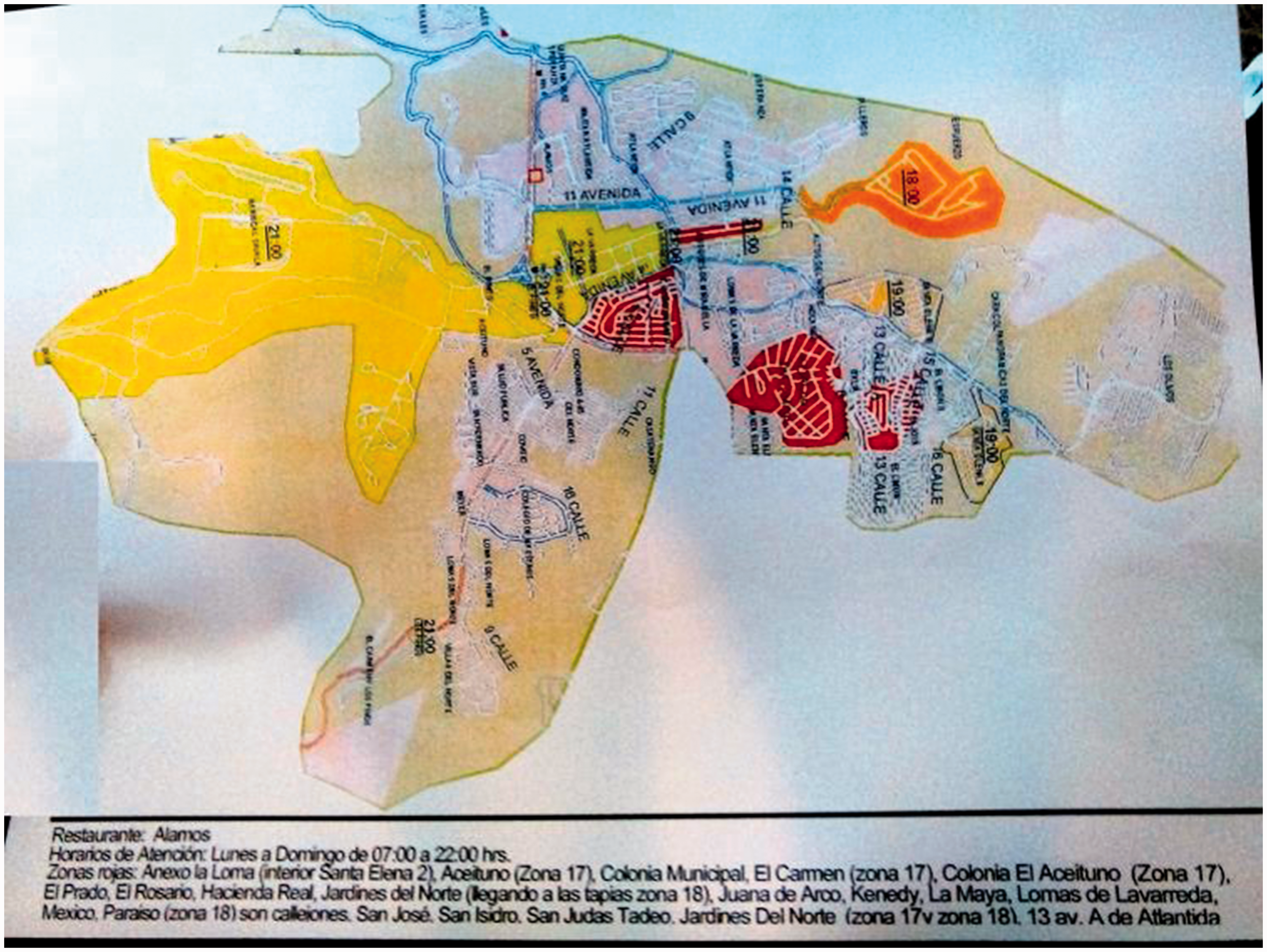
McDonald’s delivery map (2015).
“The first question that I always have is about the route,” explained one driver for Pollo Campero. “Are the streets narrow? Is there a blind spot? Does a bend in the road create traffic? These are the things that I think about.” Reflecting on these fundamental concerns, this driver listed with ease the three biggest criteria when considering a route. They are reference points echoed by almost every driver and store manager interviewed for this study. “The three things that I think about when deciding on a delivery,” he said, “are canyons (barrancos), alleyways (callejones), and roads (carreteras).”
Canyons and alleyways
El Limon and El Refugio represent the two extremes of Zone 18—its poverty and its privilege—and they are located only 50 meters apart from each other (Figure 3). El Limon is one of Zone 18’s most dangerous neighborhoods. It is rife with gang activity and extortion networks. Comprised of squat, one-story structures, the neighborhood has one main road that connects to a maze of unplanned alleyways. El Refugio, on the other hand, is one of Zone 18’s safest neighborhoods, with security walls and armed guards clearly defining its perimeter. Inside these walls, green spaces give way to small parks and picnic tables while wide and well-lit streets connect apartment buildings to parking lots.
A deep canyon, or barranco, separates El Limon from El Refugio, with these canyons characterizing much of the capital city. The short story is that the capital city sits atop pumice fill, which is a kind of gravel that has not cemented into rock. This pumice fill can stretch as much as 600 feet below street level to a V-shaped valley of bedrock. Over the years, earthquakes throughout the region have ripped the pumice, creating tears in the earth that form dramatic canyons. Exceedingly steep, they can be over 100 meters deep. One such canyon keeps the reported redness of El Limon separate from the supposed safety of El Refugio. “You have to know where the canyons are,” a driver for Domino’s Pizza explained, “and you have to know if the canyon is keeping a neighborhood safe [by creating a natural barrier against crime] or whether it is containing [or holding] the crime.”
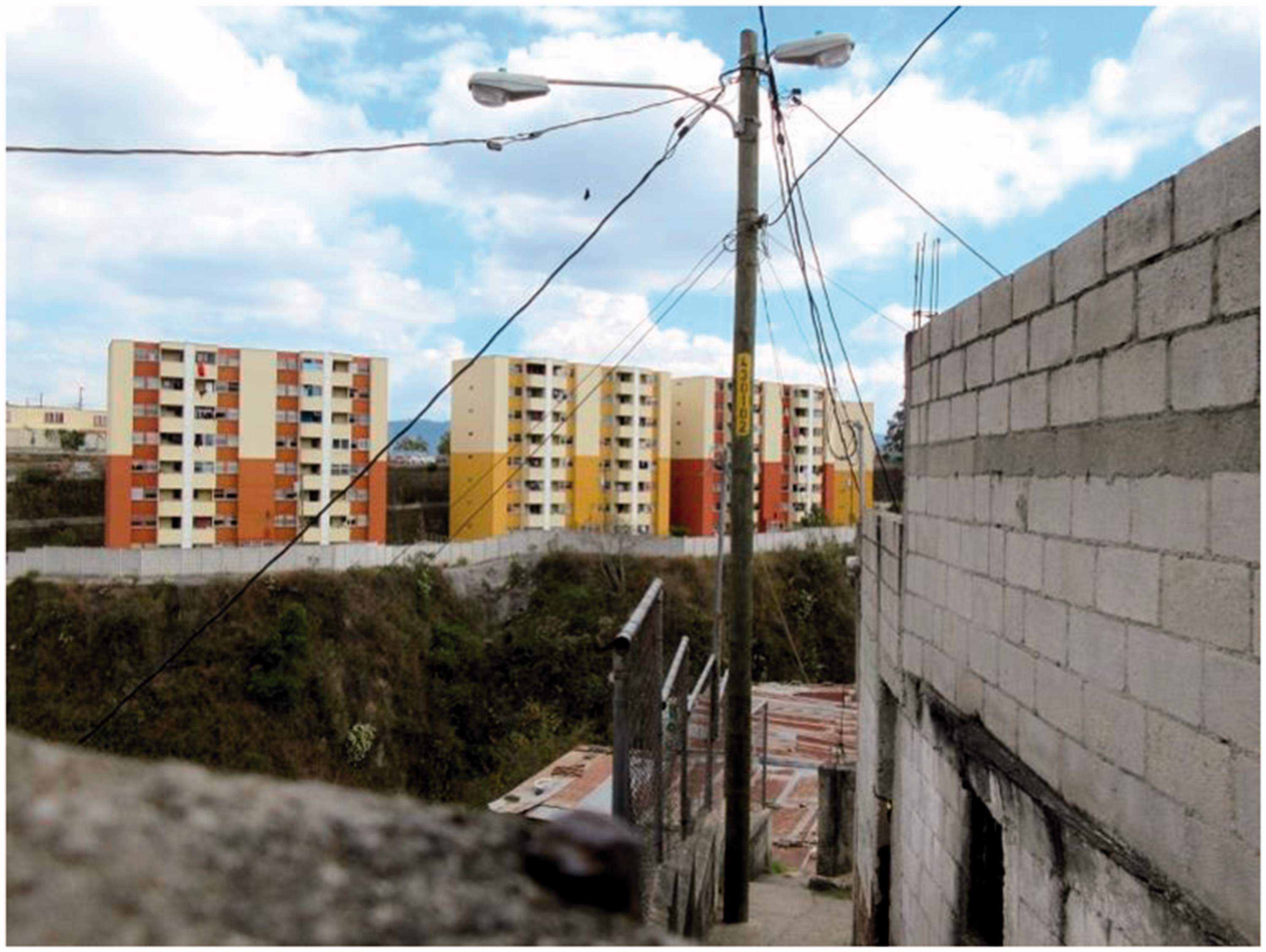
El Refugio from the perspective of El Limon (2017). Photograph by Benjamin Fogarty-Valenzuela.
Horseshoe-shaped canyons frame both neighborhoods. This means that both El Limon and El Refugio have a single point of entry and a single exit point. This benefits El Refugio but creates a disadvantage for El Limon. “El Refugio is nice because there is only one entrance,” explained a driver for Pollo Campero. “You know that everyone has to enter and exit the neighborhood the same way. There are no surprises.” Armed guards raise and lower a security gate after collecting visitor information. They also hold onto visitors’ state-issued identification cards. This is one reason why delivery personnel routinely come to know the security guards, which ultimately facilitates rapport and a sense of trust. “And once you are inside [El Refugio],” the same driver added, “you can easily drive around. You can easily make your delivery. No worries at all. Everything is safe inside the neighborhood because the canyon helps to keep the violence out [of El Refugio].” El Refugio’s generous roads contribute to this sense of safe passage. “One of Zone 18’s main roads [with four lanes] connects the restaurant to El Refugio, and so I can get there safely. And then it’s actually really nice to drive around El Refugio,” another driver for Pollo Campero added. “It’s so relaxing.”
El Limon shares a similar geological formation. Canyons frame three of the neighborhood’s four sides, but this works against El Limon. “The problem is that there is only one way to exit and one way to enter El Limon,” a driver for Domino’s explained. He walked me around the mouth of the neighborhood to emphasize the challenges that this geological formation presents him and his colleagues. “You can’t enter this neighborhood without people knowing about it,” he said. “The gangs know when we enter. Our uniforms and bikes give us away. Anyway, they know we’re here the moment we enter the neighborhood.” With the mouth of El Limon forming a natural choke point, it is impossible for delivery personnel to enter and exit with any kind of anonymity.
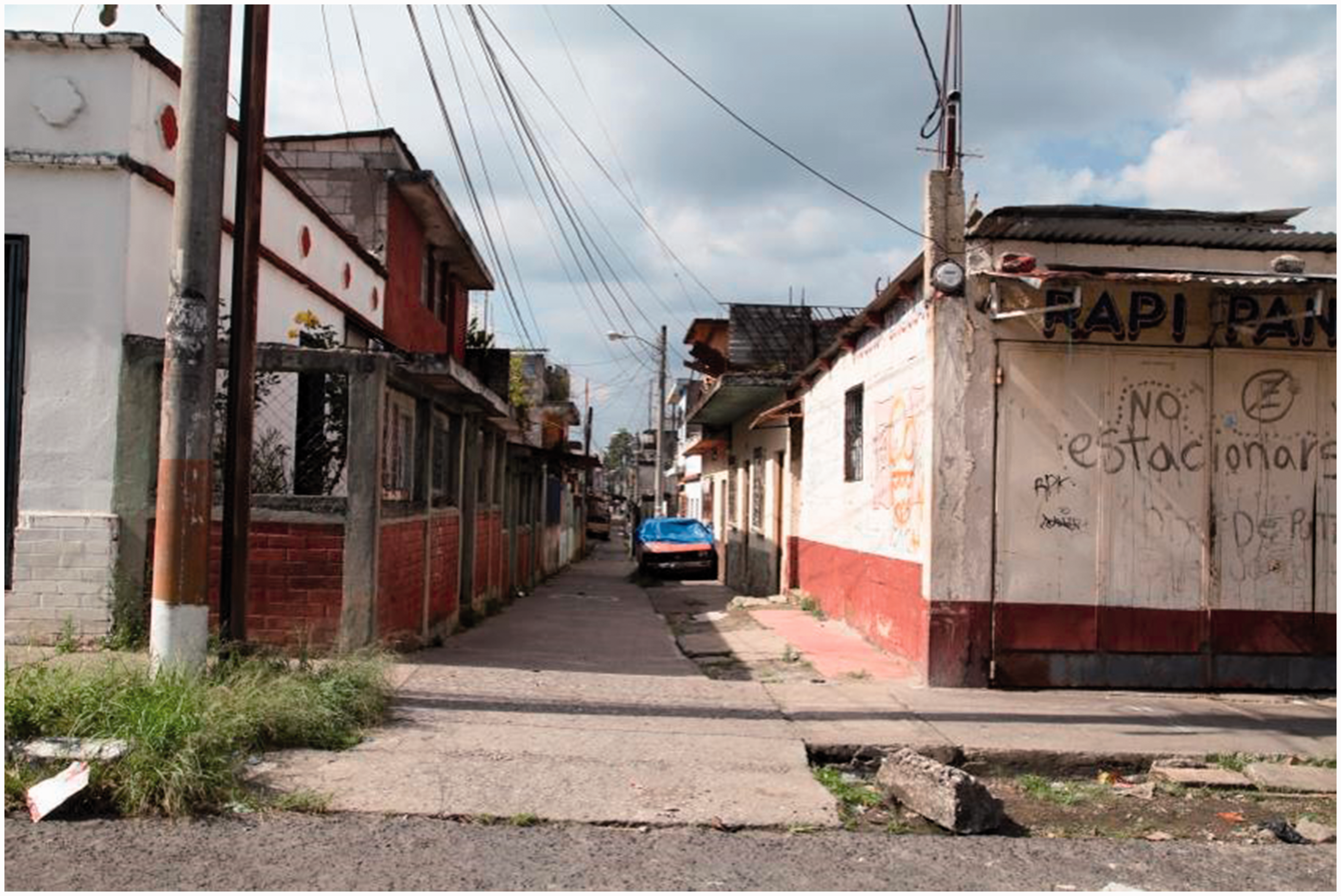
Alley (2017). Photograph by Benjamin Fogarty-Valenzuela.
Navigation of the neighborhood is also quite difficult. Rather than the broad streets of El Refugio, much of El Limon presents a maze of cinder-block houses. These structures produce tight alleyways (callejones) (Figure 4). Too narrow for cars to navigate, delivery personnel can access these spaces on their motorbikes, but then there is often not enough room for drivers to turn their vehicles around. This creates a strategic problem for delivery personnel. “We do not let our drivers enter alleyways,” a store manager for Domino’s Pizza stated flatly. “It is too easy for a driver to enter and then get stuck. Thieves can also just wait at the exit for the driver.” Drivers themselves are quick to agree. “I would feel very vulnerable in an alleyway,” another driver for Domino’s Pizza explained. “I wouldn’t be able to turn around and it’s hard to drive in an alley. It’s too dangerous.”
Roads
Vista del Prado is a polite, middle-class enclave that lies roughly 15 minutes from most of the restaurants and their delivery personnel. The enclave is replete with all the signs of middle-class security: high fences, security cameras, and private guards as well as two-story houses, two-car garages, and green lawns. This is the very suburban fantasy that advertisements for McDonald’s and Domino’s Pizza celebrate. Vista del Prado is also often compared to the most trusted enclaves in Zone 18, such as Los Olivos and Casa Florentina. It is, by all standards, equal to or even nicer than El Refugio. However, the McDonald’s delivery map names the enclave as a red zone. “It’s easy,” explained the store manager: “Vista del Prado is really safe. My cousin lives there. It’s not really red, but it’s a really long drive for our team.” Part of the route takes place on a four-lane road but then the driver must pass through La Maya on a riveted side road that presents the driver with two blind spots. This is where traffic often stalls to a standstill and where drivers must pass a series of turns. The drivers simply cannot see what lies ahead of them. “It is not a safe route,” the store manager continued, “especially because the driver needs to return to the restaurant along the same path. So thieves can see him driving to Vista del Prado and then just wait for him to come back.” It is the complexity of the route rather than the quality of the neighborhood that makes Vista del Prado red for McDonald’s and, by extension, its customers.
La Maya is the problem. It lies between El Prado and the restaurants connects the two with a series of poorly maintained and largely unplanned roads. “There is no way to arrive at El Prado without passing through La Maya,” lamented a manager at McDonald’s. “We just cannot avoid the neighborhood and its problems.” Its problems include gang violence and extortion rackets as well as theft, but the principal problem for delivery personnel is that the roads themselves fail to facilitate safe passage. “The potholes are bad,” remarked a driver for Pollo Campero, “and I don’t want to pop a tire on a delivery. I don’t want to get stranded in La Maya.” Again, mobility is the principal concern here. Circulation often equates a sense of security. “And when I’m driving to El Prado, there are those two blind spots that are really scary,” the driver continued. “I can’t tell if anyone is waiting for me because the road bends so much.” International fast food franchises are vigilant. They carefully consider and then map each potential route, knowing full well that their security depends on the ability to arrive and depart safely from an address. A red zone is not a place in the world for them but rather a shifting throughway, with La Maya creating a seemingly insurmountable challenge for the residents of El Prado.
La Maya is the reason why the residents of El Prado, as of March 2018, have banded together with the support of developers to propose the construction of a private highway that will circumvent La Maya entirely. “We’re just waiting for the highway to be built,” the same store manager from McDonald’s explained. “Then El Prado will no longer be red. Then we’ll be able to arrive there safely.” The proposed road curves around La Maya in ways that sidestep the neighborhood’s narrow choke points and troubling blind spots. “The new highway will change everything,” a driver for Pollo Campero explained. “It won’t have potholes. It will have four lanes. It will be clear. It won’t have blind spots. We won’t ever have to stop or slow down. It will be smooth.” The highway is also an exciting development for residents of El Prado, who refuse to understand their neighborhood as a red zone. “This place isn’t a red zone,” one resident explained. “Look how safe we are here. It’s just that we need to travel through La Maya to access the city. And so no one will deliver to us.” The resident continued: “If you call any of the restaurants for food, they all say no. They all say that I live in a red zone.” The resident sounded frustrated: “But the highway will connect us to the city. The highway will change our neighborhood.” There is, in fact, every reason to believe that the highway could change the status of El Prado as well as shift the sensation that this resident obviously shoulders: that of being disconnected, or, as this essay understands it, disenfranchised.
Disenfranchised
The police and international fast food franchises engage in parallel activities to map red zones in Guatemala City, but undertake decidedly distinct processes of data collection and analysis. Premised on a cartographical imagination generated through different calculations and technologies than the police, franchises map challenging parts of Zone 18 relationally in ways that offer entirely new understandings of the area. More specifically, prioritizing local knowledge of the zone offers an alternative way of assessing redness that speaks more confidently to the unpredictable nature of crime in Guatemala City. While the police are quick to paint the entirety of Zone 18 red, international fast food franchises attune themselves to such topographical and infrastructural details as canyons, alleyways, and roads to create maps that have gained incredible credence amongst residents.
Given the relationship of international fast food to the formation of postwar citizenship, the denial of a home delivery signals more than just missing out on a slice of pizza. “It’s like you don’t belong,” Maria explained, “when they tell you that they won’t deliver their food to your house, it’s like they are telling you that you do not belong.” Unlike the crime maps that have long been cast off as irrelevant due to their clunky conclusions, delivery maps carry far more affective weight, as they have acutely marked spaces of inclusion and exclusion. “I feel so embarrassed when they say that they won’t deliver to my neighborhood,” Maria said, “and their maps change so much that I never really know if my neighborhood is red or not and so I never really know which restaurant is going to deliver to my house.” Maria’s neighborhood connects to a main road and the alleyways are not too narrow, but the canyons that frame her home create a confusing confluence of factors. Of the three dozen drivers I interviewed from a range of restaurants, less than half would deliver to her address. The rest marked her and her neighborhood as red, leaving Maria living in an area constantly up for interpretation.
The term disenfranchisement tends to carry political connotations, defining the state of being deprived of a right, especially to vote. Yet it also carries a kind of brute force akin to rejection, abjection, or denunciation. International fast food franchises, although eagerly trying to expand their client base, find themselves in the business of not only mapping the relative redness of Zone 18 but also delivering the felt knowledge that some citizens belong to the city and some do not. “It is a feeling of belonging,” Maria insisted. “When Domino’s says that they won’t deliver to my home, it feels like they are telling me that my money is no good. That I am no good, and that I don’t belong to the city.” To be denied a delivery, or to be disenfranchised, is not simply to be denied a hamburger or a pizza, but also to be starved of a certain kind of membership or comradery from a corporately constructed vision of the good life. There is something subtle but nonetheless performatively powerful in having a McDonald’s driver ring one’s doorbell in front of all the neighbors. Correspondingly, it is important to account for those moments of rejection, when the driver does not park his motorbike in front of the house, does not approach the door, and does not hand over a now quintessential sign of postwar citizenship. “Then you’re just left eating beans and tortilla,” Maria lamented.
One way to account for this absence is to note, even if only briefly, those moments when crime maps and delivery maps intersect. “Sometimes when the restaurants won’t deliver to me,” Maria explained, “they agree to deliver their food to one of the police stations in Zone 18.” The 17 police stations in Zone 18 tasked with collecting crime data also double as substitute destinations for delivery personnel. “We tell the customer to go to one of the police stations,” a Domino’s driver explained, “and we complete the sale there.” The walk to the police station and back, food in hand, illustrates the shame of disenfranchisement. “It’s obvious,” Maria explained, “that the restaurant didn’t want to deliver to you. It’s the only reason why you’d walk from the police station with a bag from Burger King or McDonald’s.” Such walks reinforce the precariousness of postwar citizenship as well as the power of international fast food franchises. They have become key arbiters of postwar security, mapping red zones in ways that announce (often for all to see) who truly belongs to the city and who only lives within walking distance of it.
Footnotes
Acknowledgments
Interviews and observations in this paper come from fieldwork conducted in Guatemala City between 2015 and 2018. Those I interviewed remain anonymous or are cited by pseudonym. Quotations are from recorded interviews or from detailed notes. All translations are my own. Fieldwork was supported by the Social Sciences and Humanities Research Council of Canada.
Declaration of conflicting interests
The author(s) declared no potential conflicts of interest with respect to the research, authorship, and/or publication of this article.
Funding
The author(s) received no financial support for the research, authorship, and/or publication of this article.