
Abstract
In this first report, I overview research on storytelling of the histories of GIS. I suggest that these efforts reveal important pathways for thinking the current moment and conditioning technoscience futures. I argue that these stories around technology illustrate various disciplinary crucibles around technical practices and knowledge work. To report on progress in GIScience is also to narrate the moments of change in the discipline, whether marked as quantitative, qualitative, radical, critical, black, feminist, Marxist, indigenous, environmental, postcolonial, queer, or minor, among others. I suggest ‘minor GISciences’ to encourage attentiveness to the historical conditions and social implications of geographic technologies.
…the indifference of cartographers and remote sensing specialists for each other is appalling, given the advances likely to result from improved communication and interaction. Yet there are signs of an intellectual convergence, with geographic information systems providing the magnet. (Monmonier, 1982: 443)
I Introduction
Methods, methodologies, techniques, and technologies have long nurtured debate in the discipline of geography. The adoption and advocacy of particular ways of doing research is thought to illustrate a more basic relationship between academics and their preferred systems of inquiry. Epistemological epithets abound. ‘Do you actually do, GIS?’ Indeed, the use of GIS has been a sustained point of consideration within the discipline, even operating at times as a ‘magnet’ for ‘intellectual convergence’, as Monmonier notes above, taken from his first progress report (Monmonier, 1982: 443). Today, as then perhaps, to affiliate with GIS is to signal a particular way of doing research, which may elicit pointed opinions from colleagues.
To understand progress in GIScience is to attend to these cultures and presumptions of use. In this first report, I discuss recent scholarship that situates and permeates GIScience to take stock of the happenings that have consolidated into GIScience over the last 50 years. To do so is to engage in a writing of social histories of GIS, to understand the cultural, social, economic, and political dimensions of technical and technological progress. I argue that story-telling around progress in GIScience illustrates how technology serves as a crucible in the discipline, forcing interactions that lead to novel and imminent creations. These crucibles provide a moment to consider the role and responsibility of technical practices and knowledge work, and these considerations should not be thought outside the field of GIScience. Rather, they are inceptive.
Social histories are different from intellectual histories, although this is ‘more a matter of emphasis than of absolute distinction’ (Wickberg, 2001: 384). Social histories are less histories of thoughts/ideas, perhaps; although, of course, these are integral. Social histories are more about the relationships between thoughts/ideas (and here, technologies and methods) and social situations, institutions, and experiences. I use the plural, ‘histories’, to invoke the additive opportunities of writing social histories – that there is often more to the story. Writing social histories of GIS might both encourage more alternative, radical, and creative uses and abuses of geographic techniques and technologies, suturing thought and practice in novel ways.
II Reporting on progress in Progress
In 1969, a new journal titled Progress in Geography was launched. The first volume contained five chapters highlighting new approaches to research. Then, as now, these were meant as ‘reviews of current research’ to address an ‘information crisis’, wherein there was much geographical publication, yet little and only superficial awareness and readership. The first that would begin the tradition of reports on progress in the discipline was authored by Peter Gould (1969) and titled ‘Methodological developments since the fifties’. While not using the acronym ‘GIS’, Gould points readers to ongoing work in ‘automatic mapping using electronic computers’, addressing a concern ‘for the accurate and effective cartographic representation of data’ (1969: 7). Key early figures mentioned in this review include: Torsten Hägerstrand, Waldo Tobler, and Mark Monmonier, in the area of automated cartography; William Garrison, Michael Dacey and Duane Marble, in the area of automatic spatial data processing; 1 and David Simonett and Jack Estes in the ‘automatic processing of terrestrial images’ (1969: 8).
However, Progress in Geography would later prove unable to patch the persistent human and physical divides in the discipline. The journal’s handling of what would become GIScience is instructive, overdetermined by at least two disciplinary breaks in the pages of this journal. First, the break in 1977 into Progress in Physical Geography and Progress in Human Geography, wherein PHG assumed the topic of cartography and PPG took remote sensing. 2 Second, the break between cartography and GIS that occurred during Michael Blakemore’s second trilogy report, when Mike Goodchild picked up GIS for two reports in 1988 and 1991, and before David Unwin began a trilogy in 1994. This second break was more a slow disentangling, as the theme of cartography would return in reports on GIS, with Alan MacEachren’s reports in 1998, 2000, and 2001. 3 (Perhaps we are in the midst of another break, as the rise of digital geographies enables further consideration of the artificial separation of the technical, the human and the natural.)
Considering these breaks in the reporting of progress in Progress, as a social history of technological development written for human geographers, I describe three periods of what is now called GIScience (see Table 1). From 1977 through 1988, the topic of cartography would gradually incorporate a concern with automation. The first report dedicated to this theme, authored by Christopher Board, opens with a review of The Nature of Maps by Arthur Robinson and Barbara Petchenik, published in 1976. While most of Board’s (1977: 289) review focuses on scholarship in cartographic communication, and ‘an urgent need for theory to give relevance’ to research, he reserves one paragraph for automated cartography:
This review has concentrated on one aspect of cartographic writing, but one of fundamental concern to geographers. No apology is therefore required, but it would be wrong not to make even passing reference to automated cartography. Fortunately automated maps are no longer uncritically accepted: they are expected to inform as well as amaze their readers by their speed of production and crudity. A welcome development has been the recent publication of papers soberly weighing the relative merits of automated mapping systems and emphasizing the requirements of map authors and designers (Liebenberg, 1976; Baxter, 1976). Baxter ends on a challenging note, ‘Perhaps it would appear that the computer scientist, rather than the cartographer, has a greater role to play in ongoing research about computer drawn choropleth maps.’ What if any is the geographer’s role? (Board, 1977: 293)
Progress reports on the theme that would become GIScience, 1969 to 2020.
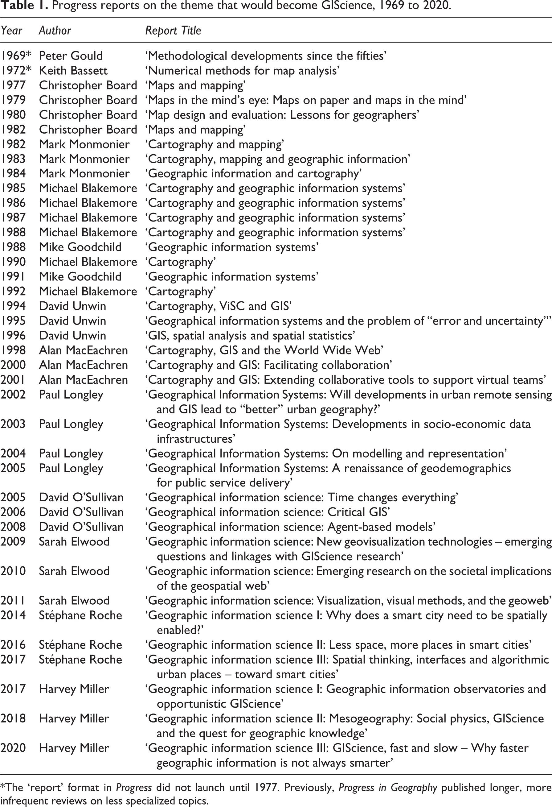
*The ‘report’ format in Progress did not launch until 1977. Previously, Progress in Geography published longer, more infrequent reviews on less specialized topics.
I quote at length because it is this passing quandary that hangs like a fog around the question of GIScience over the next three decades: What if any is the geographer’s role? If cartographic communication or ‘writing’, as Board puts it here in 1977, is of concern to geographers, how might the writing of these Progress reports constitute (and not simply report on) the wedge created by automation in mapping? The next decade of reports in this period emphasized cognition and the psychological study of map effectiveness (Board, 1979, 1980; Monmonier, 1982, 1983, 1984; Blakemore, 1986), as well as map history and the use of maps in policy (Monmonier, 1983, 1984; Blakemore, 1987, 1988). What was a discussion of ‘computer-assisted cartography’ in an entire section of Board’s (1982: 109–10) and Monmonier’s (1983: 420–3) reports becomes a recognition by Monmonier in his final report, in 1984, that ‘[s]urely our present so-called computer-assisted cartography will cease as a distinct academic and technical subfield when most, if not all, cartography is computer assisted’ (1984: 388).
The titles of the next four annual reports by Blakemore, beginning in 1985, ‘cartography and geographic information systems’, mark the rapid shift from computer-produced maps into systems for studying geographic information. Blakemore’s first use of the acronym ‘GIS’ in these reports in 1985 came alongside a recognition that the greatest utility of paper maps might be as a ‘vital last resource in an era of potential nuclear war’ when the ‘electromagnetic shock from a nuclear explosion would wipe most computers, forcing the military to resort to traditional cartographic products’ (1985: 570) In this report, we find the first explicit connection between the development of digital mapping and ‘the military funding of cartographic research’ (1985: 570).
The first report devoted solely to GIS, written by Goodchild in 1988, begins directly with provocations festering in the discipline. In the opening paragraph, he juxtaposes two quotes, one from AAG President Terry Jordan (1988: 1), who described technical GIS work in his president’s column as a ‘nonintellectual expertise’, and the second from Director Ron Abler (1988: 137) of the NSF’s Geography and Regional Science Program, who considered GIS as ‘simultaneously the telescope, the microscope, the computer and the xerox machine of regional analysis and synthesis’. As to what these differing sentiments meant for the discipline, Goodchild (1988: 560) was more open: ‘Is this the latest in a series of shortlived technical bandwagons or the basis of a genuine paradigm shift?’ He would seem to answer this by his second and final report, paired with Blakemore’s final report on cartography. Goodchild (1991: 194) writes: ‘The various GIS research agendas that have appeared in print in the past year or so are all implicit attempts to define the domain of Geographic Information Science.’
However, cartography would not remain separate from GIS in the next six reports, from 1994 through 2001. This second period is marked by reports by David Unwin and Alan MacEachren that brought the two together. Unwin begins his trilogy thus: ‘My brief is quite clear. I am supposed to bring them back together under the same umbrella’ (1994: 516). 4 The titles of reports during this period demonstrate the thematics reviewed (see Table 1). During this time, the rise of a social theoretical critique was first noted by Unwin (1995: 549–50), referencing the publication of an edited book, Ground Truth by John Pickles (1995). The first explicit attention to the internet as driving new research directions in cartography and GIS was given by MacEachren in his first report in 1998. He foreshadows the next two decades of change in web-based GIScience and the later development of a digital geographies perspective: ‘questions about the changing role of cartography and GIS for science and society’ (1998: 581). However, his reports close this period of progress on the thematics of collaboration and participation in the use of GIS for decision-making.
The third and current period of GIScience reports, beginning in 2002 with Paul Longley, would devote reports to GIS (and in 2005 to GIScience), while Progress in cartography would become a separate line. These reports have the effect of consolidating a uniquely GIScience research agenda, covering thematics in urban spatial analysis and the ‘smart city’ (Longley, 2002, 2003; Roche, 2014, 2016, 2017; Miller, 2020), models, simulations, and visualization (Longley, 2004; O’Sullivan, 2008; Elwood, 2011; Miller, 2018), geodemographics (Longley, 2005), and temporal perspectives and experiments (O’Sullivan, 2005), web-based geospatial technologies and the geoweb (Elwood, 2009, 2010, 2011; Roche, 2017), dashboards and observatories (Roche, 2017; Miller, 2017) as well as incorporating – at least for this audience of Progress readers – explicitly critical approaches to GIScience practices (O’Sullivan, 2006; Elwood, 2009, 2010, 2011).
III Stories we tell ourselves
As David O’Sullivan writes in his second report, ‘The relative lack of progress on a social history – or a political economy – of GIS is unfortunate’ (2006: 788). Here, he reviews progress on the Initiative 19 GIS and society research agenda of the National Center for Geographic Information and Analysis (NCGIA). It has been 25 years since the launch of The GIS History Project at Santa Barbara, California, as part of a larger effort of I-19. This project, now defunct (the webpage devoted to this project has not been updated since 1997), identified five primary cases studies: the use of Dual Independent Map Encoding (DIME) to create a Geographic Base File (GBF) for the 1970 US Census, the Harvard Lab for Computer Graphics, the Minnesota Land Management Information System, triangulated irregular networks, and the corporations of ESRI and Intergraph. While this list provides a glimpse into an emerging late-1990s interest in the histories of GIScience at a moment of rapid change in geospatial technologies, they are of course not comprehensive. 5 These proposed cases are illustrative of the mangle of government, military, industry and academy that articulates, through to today, the bounds of progress in GIScience and technoscience more generally (Haraway, 1997; Pickering, 1995). However, the stories we tell ourselves about this mangle cut differently. Your mileage may vary.
While we should be careful to avoid hagiography, there are undoubtedly storied individuals pushing the edges of what we retrospectively might define as the origins of GIScience. These stories weave together people and sites, funding paradigms and problem spaces, statecraft and corporate competition. These tend to tilt toward North America (problematically, as have earlier stories of cartographic innovation; see Sara Fabrikant’s corrective in 2003 and Jeanne Haffner’s book in 2013 on aerial photography in urban planning in post-war France 6 ): the Cold War-US military alphabet story, the Tomlinson-Canada GIS story, the Washington-Northwestern-Harvard story, the Dangermond-ESRI story, the Buffalo-Maine-Santa Barbara-NCGIA story, the Ground Truth-Friday Harbor story, among many others. These are but mere pathways through the mangle, perspectives on a forest while perched on a low branch. As O’Sullivan (2006) suggests, there is more work to be done, more involved individuals whose stories have yet to be told.
The situating of GIScience within these various stories continues to stir thought and action in the discipline. Following the completion of US Interstate-90 in 1956, a transcontinental freeway would connect Seattle to Chicago to Boston, paralleling a series of intellectual connections that were fomenting a computational approach to spatial analysis and mapmaking. However, there are other sites where GIScience takes hold. Oliver Belcher (2019) connects the geographic innovations in the Harvard Lab, such as the use of SYMAP, to the development of the Hamlet Evaluation System during the Vietnam War, to provide a ‘view of below’, of a calculable population in advance of war (extending work by Cloud, 2002; Crampton, 2011). In another through-line, Elvin Wyly (2019: 69) tells the story of Ed Ackerman as a figure that advocated for a ‘militarizing [of] the technical mind’, whose ideas would shape the later emergence of GIS and the discipline’s embrace of big data. These alternative histories of innovation provide different perspectives on the outcomes of the Harvard Lab (McHaffie, 2000; Chrisman, 2006; De Monchaux, 2016; Wilson, 2017) and the mangle that includes the Office of Naval Research, the Office of Strategic Services, the universities that supported geography’s quantitative revolutions (Barney, 2015; Barnes, 2008; Barnes and Wilson, 2014; Farish, 2010; Rankin, 2016), the corporations that benefited most, as well as the sites of critique and radical appropriation of these developments (Schuurman, 2000; Leszczynski, 2009; Thatcher et al., 2015). As Miller (2018: 600) argues in his second report, ‘[s]ocial physics is back’.
Archival materials are being accessioned to support work on the histories of GIScience. Paramount among these efforts is the work by John Hessler (2015) and his team at the Geography and Map Division of the Library of Congress. The LoC has collected and is making available the materials of Marie Tharp (oceanic cartography), Roger Tomlinson (Canada GIS), Waldo Tobler (early computer cartography), Nick Chrisman (Harvard Lab researcher), Frederick Doyle (remote sensing at USGS), John Snyder and Alden Colvocoresses (map projections at USGS), Joel L. Morrison (geospatial data standards), and Richard Edes Harrison (illustrator and cartographer for the popular press). As materials related to the origins of GIS span six decades, work to capture these and alternative histories should be renewed. The stories we tell ourselves about the origins of GIScience continue to inform our use of GIS, telling us more about the role of technology in our discipline today. As Barnes (2014: 206) writes, invoking Faulkner, ‘past and present are inextricably joined. We cannot escape history because the past never fully passes. Instead, we carry the burden of the past into the present, bringing with us what went before.’
IV Toward minor GISciences
Epistemology is the weapon of critical GIS, to attack technological developments in GIS and cartography. However, it is not essential to many GIScientists, since knowledge in GIScience is built through commitments to scientific methods and falsifiability, not by radical aspirations. (Tsou, 2019: 175)
Many origin stories of GIScience serve to bind together various geospatial experiments into a science. Of course, there are benefits to such a molar formation. 7 There are also, however, many molecular histories that move, often imperceptibly, around and throughout these more popular accounts. Borrowing the language of Deleuze and Guattari (1987), especially as taken-up in geography (Katz, 1996, 2017), I suggest minor GISciences, to think and act differently with and against GIS. 8 To do so is to recognize that the debates around GIS in the discipline of geography are not external to the discipline but are rather important crucibles for disciplinary change. Minor theory, as developed by Cindi Katz (1996: 489), ‘is not a theory of the margins, but a different way of working with material’. Perhaps this is why Tsou’s recent sentiment above is revealing; this different way of working continues to draw a disapproving side-eye – that, according to (some) GIScientists, radical aspirations or epistemological approaches cannot build knowledge. What if we were to think radical, critical, and ‘renegade cartographies’ as Katz (1996: 494) proposes, as motivating molecular elements characterized by escape: ‘minuscule at first, then swelling, without, however, ceasing to be unassignable’ (Deleuze and Guattari, 1987: 216)? 9 How are minor GISciences moving in and around the discipline, catalyzing important changes without drawing much attention?
Sarah Elwood’s reports on GIScience (2009, 2010, 2011) provide a sustained accounting of a variety of these molecular movements in such a renegade, or minor GIScience (restless and resistive geovisualization as well as situated political and social struggles over spatial data and the geoweb). These reports also represent the only authored by someone other than a white man after nearly 40 years of Progress in GIScience (see Table 1). Continuing today, Elwood (2020) charts and supports a series of escapes in GIScience (without naming ‘GIS’ as such); for instance, her invited Progress lecture at the 2019 AAG Meeting highlights a ‘thriving otherwise’ approach in digital geographies, ‘theorizing digital geographies at the intersection of feminist relational thinking and Black, queer/trans, and feminist code studies’.
There are other lines of flight that do things differently in GIScience (and often are not published in leading journals of the field such as IJGIS). 10 Indeed, the stories of precision and objectivity in GIS can disguise the ontogenetic properties of digital mapping. As Brian Jordan Jefferson (2017: 789) argues, these stories of GIS mask ‘the material forces that engender crime rates’ and enable further harm, preserving ‘punitive solutions as taken-for-granted approaches to reducing these rates’. Alongside discussions of ‘smart’ technologies and algorithmic governance in recent reports (see Table 1), work by Agnieszka Leszczynski (2020: 202) theorizes the operative field of the glitch in digital platforms, rendering ‘them legible such that we may meaningfully intervene’. GIScience is overdetermined by its social and political conditions, but this has not meant that the discipline should surrender these tools. As Caitlin Buckle (2020: 84) demonstrates, GIS can be used, qualitatively, ‘to perform and represent lived experiences of migration’. Taylor Shelton (2018: 1078) offers another approach to doing critical GIS, quantitatively, ‘to produce a more complex and process-oriented understanding of how poverty is produced in conjunction with affluence’. The role of minor GISciences is to tell other stories of and with GIS.
Revisiting minor theory, Katz (2017: 596) writes that it is ‘not a distinct body of theory, but rather a way of doing theory differently, of working inside out, of fugitive moves and emergent practices interstitial with “major” productions of knowledge’. Work that moves in minor GISciences is expansive; it is additive, not subtractive. As such, this work often remains imperceptible to the molar formations of GIScience, and yet these interventions enact and diffract disciplinary change. These minor GISciences intervene with the Euclidian system (Lally and Bergmann, 2021) and cartographic classification (Wilmott, 2019). They document the appropriations of indigenous knowledges through state-based GIS practices (Palmer and Feyerherm, 2018) and design alternative GIS pedagogies (Elwood and Wilson, 2017; Ricker and Thatcher, 2017). They queer GIS by using ‘good enough software’ (Gieseking, 2018: 55). They geo-visualize war, violence, and incarceration (Kurgan, 2013) and map housing evictions (Maharawal and McElroy, 2018) and economies of solidarity (Pavlovskaya, 2018). Minor GISciences reactivate data science itself (D’Ignazio and Klein, 2020; Loukissas, 2019). As COVID-19 preys upon the precarious, uneven and unjust interconnectedness of the planet, molar formations of GIScience may reduce geography to a dashboard. Recognizing these mappings as far from enough, our minor GISciences continue their work, often imperceptible to the major, but as essential crucibles for progress otherwise.
Footnotes
Declaration of conflicting interests
The author(s) declared no potential conflicts of interest with respect to the research, authorship, and/or publication of this article.
Funding
The author(s) received no financial support for the research, authorship, and/or publication of this article.