
Abstract
River restoration as a science needs to balance numerical analysis with a more general systems understanding typical of a classification-based approach. We show the need for this balance by comparing the Davis–Gilbert debate in physical geography to the current ‘Rosgen wars' (Lave, 2008) in fluvial geomorphology and river restoration. In both controversies, one perspective was accepted for a period of time, but then subsequently vilified by vocal members of the discipline. However, in the process of replacing one paradigm with another, former viewpoints are often misrepresented and set up as contradictory to the newer paradigm. Careful reconsideration of Gilbert’s and Davis' approaches to geomorphology shows them not as mutually exclusive, but rather as complementary. Observation and nomenclature, as well as measurement and process analysis, are not only parts of the general temporal progression of a discipline, but are complementary scientific approaches. Davis' nomenclature and Gilbert’s analytical processes are both necessary to understand and discuss landscape geomorphology. Similarly, both Rosgen’s classification system, or one like it, and other more analytical, process-based examinations, are necessary for a comprehensive approach to river restoration. It is clear that multiple viewpoints and approaches triangulate towards a more thorough understanding of a system and will increase the probability of successful restoration. This will most likely include system-wide observation and classification married to numerical process modeling.
I Introduction and historical review
Observation and nomenclature, and measurement and process are all parts of the development of a discipline over time. As such, in many natural sciences, studies based largely on observation and nomenclature are often viewed as dated in comparison to those based on measurement and process understanding. This creates a cycle where new ideas or paradigms are treated as replacements for previous work. In some ways, this encourages useful discussion and momentum within the discipline. However, complete dismissal of the old without a backwards glance can obscure useful viewpoints or information from our disciplinary roots. Frequently, this creation-rejection cycle sets ideas as mutually exclusive when they may have been intended, and could still be used as complementary. ‘The foundation of a science is in its published literature’ (Schumm, 1972: 3).
Return to original papers and reexamination of contemporary science in light of these original works is indispensable to continued development of a discipline and why this journal sustains its ‘Classics revisited’ section. Comparison and contrast of the Rosgen debate (described below) in relation to channel design through the lens of past debates may help us to get out of the current oppositional rut to generate better understanding of fluvial systems. In this article, we compare a past example of the creation-rejection cycle (W.M. Davis and G.K. Gilbert) to a current ongoing debate in the field of river restoration. Our historical review here is brief, as other more thorough treatments are available elsewhere (e.g. Pyne, 1980; Sack, 1992).
1 Geomorphology: the science and its history
Geomorphology describes and analyzes the features of the Earth’s surface to understand the ways in which surface processes operate and control the development of those features and landscapes. W.M. Davis and G.K. Gilbert were key figures in rooting geomorphology within the physical sciences in the late 19th century.
Davis (1850–1934) was a physical geographer with national and international prominence in geography and geology. He was a founding member of the Association of American Geographers, and lectured extensively worldwide. Through his status as a geography professor at Harvard, he held not only a premier position in the heart of the American academe, but also the opportunity to train some of the most influential geographers and geologists of the 20th century.
Davis is most often linked to the concept of the ‘cycle of erosion’ or the ‘geographical cycle’ in which landscapes evolve through a series of relative ages from youth, to maturity, to old age. Davis identified landforms as the result of structure, process, and time, and while he wrote on the importance of structure and process, he heavily emphasized the role of time in landforms. Though he speculated in his manuscripts on mechanisms involved in the formation and change of landscapes, Davis' focus was mainly on their deterministic progression in sequence from one form to another. In his view, time was an inevitable force under which landscapes evolved in an orderly and predictable fashion. Process cannot, however, complete its work instantly, and the amount of change from initial form is therefore a function of time. Time thus completes the trio of geographical controls, and is, of the three, the one of most frequent application and of most practical value in geographical description. (Davis, 1899: 482)
Davis continued to refine his theoretical model for many years (Thorn, 1988). He suggested that the study of forces is not the job of the geomorphologist, yet stressed the genetic basis of the classification, and that the name would give some information about the genesis of the form. The forces by which structures and attitudes have been determined do not come within the scope of geo-graphical inquiry, but the structures acquired by the action of these forces serve as the essential basis for the genetic classification of geo-graphical forms. (Davis, 1899: 482)
In this way, Davis, as a founder of physical geography, was doing science the way science was done at the time: naming, organizing information, and incorporating the popular Darwinian metaphor. Others embraced this approach as well; the geographer Hartshorne firmly believed the domain of geography was orderly description (1958: 108). In fact, this approach to science was not unique to geomorphology, but was shared across many disciplines. For example, the ecologist Forbes, author of much foundational aquatic ecology, stated: The first indispensable requisite is a thorough knowledge of the natural order – an intelligently conducted natural history survey. Without the general knowledge which such a survey would give us, all our measures must be empirical, temporary, uncertain and often dangerous. (Forbes, 1880: 15)
Gilbert (1843–1918) spent the majority of his career with the fledgling US Geological Survey, and participated in some of the most influential geologic surveys in the United States, including the Powell Survey of the Colorado River. Gilbert is best known for his work on landscape structure and processes in the Henry Mountains of Utah (Gilbert, 1877) and the transport of hydraulic gold mining debris on the Sacramento River in California (Gilbert, 1917). Gilbert approached landscapes from a process perspective in which he used the scientific method including hypothesis testing to identify and analyze the forces at work which caused a particular observed landscape, an approach argued to be exemplary for current geomorphologists (Baker and Pyne, 1978). Indeed, his observations and theories remain the source of much contemporary research (e.g. James, 1999; Johnson, 1970).
Yet his work was an outlier in comparison with the natural history approach typical of the time. While others collected and classified plants, animals, and landforms, Gilbert often employed methods more common in engineering, including free-body diagrams for his work on laccoliths and flumes for his work on river sediment transport (Tinkler, 1985). His focus on quantifying the processes involved in causing observed features is evident throughout his work. For example, in regards to meander migration, Gilbert observed: The first result of the wearing of the walls of a stream’s channel is the formation of a flood-plain. As an effect of momentum the current is always swiftest along the outside of a curve of the channel, and it is there that the wearing is performed; while at the inner side of the curve the current is so slow that part of the load is deposited. In this way the width of the channel remains the same while its position is shifted. (Gilbert, 1877: 126)
Though he lectured at Columbia and Johns Hopkins, Gilbert turned down faculty positions at Brown and Cornell (Davis, 1918; Sack, 1991) preferring to stay with the USGS. Instead, he believed in education by example. We need for educational purposes more narratives of good work in all departments of research. Let the discoverer of a new principle recite every hypothesis that occurred to him in the course of his search, telling, if he can, how it was suggested. Let him lay bare the considerations which rendered it plausible, the tests that were conceived, and those which were applied. Let him show in what way the failure of one hypothesis aided in the invention of another … He will inspire the young investigator by his example, and even his experienced compeer will take courage from the success that after many failures finally crowns his efforts. He will give to every investigator who reads his paper a lesson in method – a good lesson if his method is good, and not necessarily a bad one if his method is bad. He will therefore educate his fellow workers. (Gilbert, 1886: 289)
2 Change in the discipline
Gilbert and Davis were prominent at different times. It was Davis' historical view of geomorphology that dominated geomorphic investigation for the first half of the 20th century, and Gilbert’s for the latter half. Davis' predominantly qualitative view, and particularly the largely untestable theory of landscape development through the geographic cycle, was later broadly challenged in geography and other natural sciences.
Geomorphology as a discipline switched from Davis to Gilbert somewhat dramatically in the mid-20th century. At a symposium, ironically held in honor of Davis, Arthur Strahler, a geomorphologist at Columbia University, attacked the historical (i.e. Davisian) approach as a ‘superficial cultural pursuit of geographers that is completely inadequate as a natural science’ and that ‘those geomorphologists wishing to make substantial contributions to science must adopt a quantitative-dynamic approach to landform studies' (in Sack, 1992: 255). Strahler’s own research focused on the need to quantify the relationships between form and process – that is, to adopt the physical process approach introduced by Gilbert.
Following some initial resistance to this paradigm change, the geomorphic community rapidly adopted the Gilbert/Strahler approach to geomorphology. Observational surveys were rejected across many disciplines in favor of more specific, quantitative, and process-based approaches. For instance, the geographer Peter Gould described the older pre-1950s geographers as guilty of ‘bumbling amateurism and antiquarianism that had spent nearly half a century of opportunity in the university piling up a tipheap of unstructured factual accounts (Gould, 1979: 140).
Similarly, the geographer Fred Schaefer dismissed the old methodology of Davis and Hartshorne. Hailed as a father of the quantitative revolution in geography, Schaefer called for geography to undertake a search for general understanding and geographical laws. This included (a) adoption of more quantitative methods and (b) use of hypothesis testing. Both were heralded as more scientific approaches to geography (Schaefer, 1953), a discipline that was being abandoned in academe for its lack of scientific rigor and identity (Smith, 1987). By the late 1950s, Davis' work was caught up in the general criticism of early 20th-century geography. Indeed, the remaining presence of Davis in popular textbooks has been described as ‘something of an embarrassment, like a distant elderly relative at a teenager’s party’ (Tinkler, 1985: 150).
Whatever the reason, Davisian geomorphology was replaced wholesale. In the latter 20th century, the work of G.K. Gilbert was removed from the history vaults, dusted off, and labeled as the new gold standard (Baker and Pyne, 1978).
3 In defense of Davis
Any comprehensive dismissal of previous work, especially such foundational work, runs the risk of excluding potentially viable information and theory. A re-evaluation in defense of Davis shows that his approaches were necessary to the discipline, were often misrepresented, have not been completely abandoned or disproven, and may still provide complementary alternatives to modern process geomorphology.
Davis' work in geomorphology was a necessary step in the trajectory of the discipline of geomorphology. When he started his career, geography had just emerged from geology and was still in its disciplinary infancy, or ‘an uncompleted jigsaw’ (Tinkler, 1985: 144). His descriptive, historical geography was a necessary building block upon which process geomorphology could be built. Chorley was highly critical of Davis' emphasis on vocabulary, or ‘his obsessive concern over terminology’ (Chorley, 1970: 31). However, creation of a common nomenclature is absolutely necessary for eventual synthesis of data and as a basis for clear dialogue. This step is preliminary to empirical measurement and hypothesis testing. Without pattern and nomenclature, causal processes cannot be hypothesized or tested. At the early stages of any discipline, hypothesis testing is just not effective (Loehle, 1987).
Misrepresentation and misinterpretation may have had a large role in the rejection of Davis' work and ideas (Sack, 1992). He was commonly rejected as ignorant of or uninterested in process. However, a rereading of his work shows that though not a priority, Davis was interested in process, as can be seen in his interest in river meanders (Davis, 1899: 494). Chorley also accused Davis of relying too heavily on ‘verbal logic’ (Chorley, 1970: 31), and quoted Bryan: ‘He [Davis] has always substituted words for knowledge, phrases for critical observation’ (Bryan, 1940: 254, as quoted by Chorley, 1962).
In many ways, this grossly misrepresented Davis, whose work resulted from a great deal of observation (Sack, 1992). He also based much of his work on the considerable observations, data, and analysis of Gilbert. Davis' general theory of landscape change over time was a direct result of Gilbert’s data (Tinkler, 1985) and ideas of grade: The original excess of ability over work will thus in time be corrected, and when an equality of these two quantities is brought about, the river is graded, this being a simple form of expression, suggested by Gilbert, to replace the more cumbersome phrases that are required by the use of ‘profile of equilibrium’ of French engineers. (Davis, 1899: 489)
Comparing Davis' work to Gilbert’s is not wholly appropriate; the two pursued fundamentally different questions. Gilbert developed his multiple working hypotheses of individual processes. Davis took individual observations of individual landscape features and synthesized a landscape perspective. Chorley (1970: 30) describes Davis' emphasis upon historical sequences as ‘antique’. But the goal of the historical approach was the interpretation of landforms (Baulig, 1950). Strahler and others in the 1950s–1960s called for the prediction of landform development and process (Strahler, 1952), but comparison of a historical approach with a process approach is like comparing a glass to the water within it … inherently different substances which only function together. Like the water without the glass, process geomorphology has no shape without historical and landscape context. Without process, historical geography lacks purpose.
Richards suggested that there is a ‘spectrum of appropriate methodologies' from the physical sciences to the social sciences. Instead of, or in addition to, falsification, Richards advocated ‘corroborative’ science that addresses a particular problem through varied approaches and multiple methods (Richards, 1994: 279–280). Indeed, ‘We do well to see such methodological shifts not as replacements but as displacements by which new concerns and procedures are added to the repertoire’ (Bowler and Pickstone, 2009: 5).
This should caution us against wholesale replacement of methods or theory. Part of science should involve the use of multiple methods to triangulate towards better understanding. This is particularly important in composite sciences (Osterkamp and Hupp, 1996), such as river system science, which incorporate multiple disciplines, methodologies, and viewpoints.
II River system science
Rivers are a central area of study in geomorphology. Some of the earliest geomorphic and geologic observations of the earth’s surface center on fluvial processes, and the majority of the most-cited works in geomorphology are based on fluvial processes (Doyle and Julian, 2005). By examining how approaches to geomorphology, especially fluvial geomorphology, have changed over the past 100 years, we can see how river classification and restoration design strategies fit within the changing paradigms of research and application. This assessment highlights the contrasts and similarities between river classification systems grounded in ‘historical’ geomorphology (Davisian), and process-based approaches more consistent with ‘process' geomorphology (Gilbertian). One method provides a useful vocabulary and general understanding while the other stresses specificity, uniqueness, and understanding of individual process. Both attempt to predict river channel form as a consequence of disturbance for use in stream channel design. In spite of the current popularity of stream restoration as an industry in the United States, both methods still often fall short of the mark (Kondolf et al., 2003; Shields, 2009; Shields et al., 1999).
1 Emergence of the industry of river restoration in the United States
River restoration is the practice of returning targeted aspects of river channels to some semblance of their biological, physical, and chemical conditions prior to anthropogenic disturbance or modifications (National Research Council, 1992; Rhoads et al., 1999) or to a new functional condition in response to changing state variables (e.g. climate, hydrology) (Battin et al., 2007). What started as a relatively limited endeavor by local fishing clubs to enhance trout fishing (Thompson and Stull, 2002) has become a billion dollar a year industry in the USA alone (Bernhardt et al., 2005). Because of this burgeoning industry, river scientists have found an increasing demand for their expertise, and their science has come under increased scrutiny from the public (Gordon, 1990; Malakoff, 2004).
River restoration has gained prominence in the scientific community as it allows a direct application, if not testing, of many existing theories to a salient environmental problem. While river restoration certainly draws on an array of scientific disciplines, the role of geomorphologists for actual channel design is the core of most restoration projects. Geomorphologists have been called on to make assessments of geomorphic stability of a channel or watershed, develop alternative forms of river bank stabilization techniques (i.e. vegetation rather than stone rip rap), and use geomorphic principles for creating habitat for endangered aquatic species (Brookes and Shields, 1996). Perhaps the most daunting task given to geomorphologists has been stable channel design (Shields et al., 2003), wherein a completely new channel is created to restore natural environmental biotic and abiotic functions.
Designing a river channel that will maintain stability over time necessitates not only an understanding of the local processes of water flow and sediment transport, but also a larger view of the river within the watershed and landscape (Montgomery, 1999; Sear, 1994), and a coupled understanding of physical and biological processes (Ormerod, 2004; Sweeney et al., 2004). It also requires a firm grasp of goals, or what ‘stability’ means. Many designs state that they aim for ‘dynamic equilibrium’ (Juracek and Fitzpatrick, 2003; Kondolf et al., 2001) with the understanding that channels, like all natural rivers, move. Others equate stability with dynamic equilibrium of sediment, assuming that sediment coming into a reach equals sediment leaving a reach (Hack, 1960). Yet others, particularly designers trained as engineers tend to mean ‘stable, stable’. They are designing a channel that will move neither laterally across a floodplain nor vertically in the bed, ever (Lave, 2009). In such a channel, a coupled understanding of physical and biological processes is often just ignored.
While some tasks given to geomorphologists may have only limited societal implications, failure of channel designs can have substantial financial and safety consequences including excessive postconstruction erosion or deposition, undermining of local structures, and altered flood regimes (see Kondolf, 1995). An increasing number of failed restoration projects (e.g. Kondolf et al., 2003; Shields et al., 1999) and the question of whether or not restoration delivers on its promises (Palmer et al., 2005; Bernhardt et al., 2005) led us to examine the fundamental role of geomorphology in river restoration channel design. Because of its relative infancy, there has been great debate about approaches to the geomorphic problem of river restoration channel design. In the past two decades in the USA, two primary approaches have emerged: (1) classification approaches; and (2) process-based modeling approaches. The Davis/Gilbert debate has emerged in a new form.
2 Classification versus modeling
For many years geomorphologists sought to simplify the myriad of geomorphic forms into coherent classifications, and examples abound for channel classifications (Simon, 1989) as well as classifications of other geomorphic features (e.g. Nanson and Croke, 1992). Classification refers generally to the process of ordering objects in groups, the result of a system of groups, and also the application of the resulting system (Kondolf et al., 2003). The process, result, and application can each be useful to stream restoration by: (1) inventorying existing conditions and setting priorities for restoration; (2) envisioning an end state toward which restoration should proceed; (3) providing initial indications about restoration measures likely to succeed in a given channel; and (4) providing general vocabulary for communication. Classification allows relatively rapid inventory and possible identification of common characteristics and behavior patterns. For many classifications, some data are collected (e.g. channel width, slope, grain size) to quantify channel form and features in order to place the channel within the appropriate channel type. Any classification scheme involves simplification of the systems, choice of which types of variability are relevant, and a balance between generality and specificity.
The dominant approach in the USA, in terms of the number of people using it, is the classification approach to channel design. Outside of the USA, the classification approach to natural design is substantially less prevalent. The classification system applied specifically to river restoration can be traced to the mid-1990s when the Rosgen classification was introduced (Rosgen, 1994; 1996), and was taught in a series of short courses (typically five days) on river restoration. These short courses provide intensive introductions to Rosgen’s classification method and his suggested levels of analysis for river systems. Over the past decade, similar short courses have been developed by environmental consulting firms, non-governmental organizations, and government agencies, with many leveraged off the Rosgen classification approach, and others providing background on the modeling-based approach. These short courses provided many biological scientists, and perhaps some engineers, with their first exposure to the discipline of fluvial geomorphology and the concept of geomorphically based channel design. Over the next decade, many governmental agencies have used the short course format as a method of introducing their personnel not only to fluvial geomorphology, but to the emerging discipline of river restoration.
Many classification approaches are appropriate to use for the reconnaissance and evaluation stages of channel design (see Kondolf et al., 2003, for a review). The most commonly used classification system in the USA is Natural Channel Design (NCD) (Rosgen, 1994). NCD requires analysis over several stages including reconnaissance, evaluation of catchment-scale geomorphic features and processes, historical analysis of channel conditions through time, and finally actual specification of channel geometry (Brookes and Shields, 1996).
For river restoration purposes, the classification approach to channel design is intended to help a designer ‘predict a river’s behavior from its appearance’ (Rosgen, 1994), and that by assigning a reach of channel a classification (such as A2, C4, B6), one can assess the channel’s present stability, past conditions, and probable trend if left undisturbed. For many classification systems, assessing the appropriate classification of a river reach requires relatively simple measurements, extensive use of statistical relationships from the literature, and minimal analysis. Classifications, like the Rosgen classification, quantify channel form and not the processes that have led to the observed forms. Thus, classifications are often easy to learn and rapid to use, particularly for those without a background in geomorphology.
Classification approaches in restoration have a certain degree of value: for initial education and communication, they are extremely valuable, and this application of the Rosgen classification system in particular has always been acknowledged (Miller and Ritter, 1996). Further, there are several process-based classifications available that facilitate an assessment of likely future geomorphic conditions based on current forms, although these are based on specific geomorphic processes and conditions for particular regions (e.g. Montgomery and Buffington, 1997; Simon, 1989).
However, limitations must be noted regarding the use of any classification system, particularly for use in channel design. In particular, it is the use of classification beyond initial characterization and communication that many argue should be avoided. Consequently, their use in the actual design of channels has been widely criticized for several reasons. First, classification systems tend to oversimplify the complexity of the fluvial system and tempt unqualified persons to attempt restoration design without proper knowledge or experience. To have a minimal understanding of a fluvial system, even at the river reach scale, a designer (or a design team) must be capable of applying watershed hydrology, hydraulics, geology, geotechnical slope stability, sediment transport, stream ecology, and hydrology, at a minimum, all within a geographic understanding of the surrounding watershed and landscape (Montgomery, 1999). Kondolf (1995) notes that classification systems tempt non-geomorphologists to consider the river ‘known’ once it has been classified. The geomorphologist recognizes that the classification is only the beginning of the analysis process, and that it is the quantitative analysis after classification that makes restoration design feasible. A well-trained geomorphologist should be able to choose from an array of potential analysis tools. However, dependence on classification systems, coupled with only a vague familiarity of fluvial geomorphology and some empirical equations, may indicate an inadequate basis of expertise from which to attempt a river restoration project.
The second reason for limiting the use of classification systems is that the scientific basis for extending classification systems beyond simple stratification of channel forms has been criticized more often than substantiated (Kondolf, 1995; Miller and Ritter, 1996). Thus, there is not a strong scientific basis for using classifications in the role of channel design, and there are certainly stronger bases for using alternative approaches. Further, the increasing number of failed classification-based designs suggests substantial limitations to this approach (Shields et al., 1999).
In addition to (or perhaps in contrast to) the classification approach is the process-based modeling approach. In this approach, specific physical processes are quantified using available numerical models, and then the sensitivity of the stream to changes (e.g. runoff alterations, re-meandering) is examined using these models to predict future channel conditions. Models can range from simple univariate regression equations to complex dynamic models that combine numerous submodels. Data are collected for modeling approaches in order to constrain the model parameters and predict future conditions. Data needs for modeling approaches are often more substantial than for classification approaches, making these methods both costly and time-consuming. Beyond channel geometry, other aspects of channel morphology may also be analyzed using available models, such as bank stability models for assessing the role of vegetation in soil stabilization (Simon and Collison, 2002; Sweeney et al., 2004). The process-based modeling approach tends to be the dominant approach adopted by restoration designers with advanced backgrounds in geomorphology or engineering (Shields et al., 2003).
The foremost advantage of the process-based approach is that it is well established in the scientific and engineering literature. For decades, geomorphologists and hydraulic engineers have been quantifying river processes and developing models that describe these processes, and these models have been tested and refined over time. In the past, process-based modeling may have been limited by the availability of either computational resources or numerical models. However, with the proliferation of personal computers, and the increased availability of free or low-cost numerical models, there is great potential to quantify river processes via numerical modeling. Further, government agencies like the US Army Corps of Engineers' Hydrologic Engineering Center have devoted considerable effort into user-friendly interfaces of these models – e.g. Hydrologic Engineering Center – River Analysis System HEC-RAS (Brunner, 2010).
The final advantage of the process-based approach is that it allows one to quantify the limitations of the designed channel. Almost no channel design will withstand a 1000-year flood. However, quantifying whether the designed channel can withstand a 20-year flood is only possible with detailed analysis of the hydraulics and sediment transport capacity of the channel. This has two distinctive advantages. First, it allows explicit communication of the limitations of the channel design to the funding agency, e.g. the design of this channel should withstand flows up to the 20-year event (which has a 5% chance of occurring in any year), beyond which the stability cannot be guaranteed. If this level of uncertainty is unsatisfactory, then the design can be revisited to provide stability for a greater flood event, and the process can be iterated as needed between the design and management team. Second, this approach allows direct quantification of analysis that might have gone wrong. For instance, if a project fails, then the designer can examine what specific aspects of the project failed, and isolate where the design went wrong in their analysis, thus potentially specifying the analytical flaw or the aspect that was beyond design control or could not be accounted for in analysis. This allows refinement of specific aspects of the design process to ensure future successes.
As with any approach, process-based design also has its limitations. Similar to the classification approach, anyone can download HEC-RAS and most of the other commonly used programs for free, insert numbers and hit ‘START’. While the use of these models is most likely only introduced to people taking actual geomorphology classes or some other type of formalized training, the temptation to use existing models and tweak parameters without proper understanding is formidable. The quality of the data entering the model is extremely important, though this is often ignored. For example, modeling discharge is extremely sensitive to elevation and Manning’s roughness coefficient, and small errors can be propagated and magnified through models.
There are similarities between the classification and process-based approaches; both require choice of relevant variables, simplification, and balance between generality and specificity. While many see the two methods as mutually exclusive, when used in channel design both approaches attempt to predict behavior so that designers may alter the stream structure, jumping ahead to an alternative and preferred new equilibrium condition.
Since the mid-1990s, the classification approach has become widely, and perhaps dominantly, adopted by governmental agencies in the USA, particularly those funding restoration projects (Malakoff, 2004). For example, in contributing to project funding, the Montana Natural Resources and Conservation District often requires designers to demonstrate in proposals ‘experience in the use and application of a stream classification system and its implementation’ (Montana Department of Fish, Wildlife and Parks, 1998). Similarly, classification systems have been utilized in evaluation guides for riparian areas and US Forest Service management plans. Most notably, many highly trained geomorphologists and hydraulic engineers are often held suspect, or even thought incorrect, if their approach does not include reference to or application of a classification system (Malakoff, 2004). While design specifications from state and federal agencies do not specify the Rosgen classification, personal experience by numerous geomorphologists suggests that the Rosgen classification is the only form of channel classification accepted by these agencies (Kondolf et al., 2001; Malakoff, 2004).
III Restoration and geomorphology
The classification approach to river restoration in some ways mimics Davis' approach to landscape geomorphology, particularly in the emphasis on the classification system. Davis' classification system was particularly important for its use of a common language and was designed to be accessible to people of many different levels of education. The Rosgen classification system with its 42 categories is not meant for the uninitiated, but it does serve the purpose of condensing a large amount of information into a short phrase (Lave, 2009). Both Rosgen and Davis see the current landscape as the result of the integration of multiple processes without much emphasis on the individual processes. The conviction that there is an inevitable and deterministic march of one channel form to another over time, given certain types of disturbance, is common to both and is the most questioned aspect of their approaches.
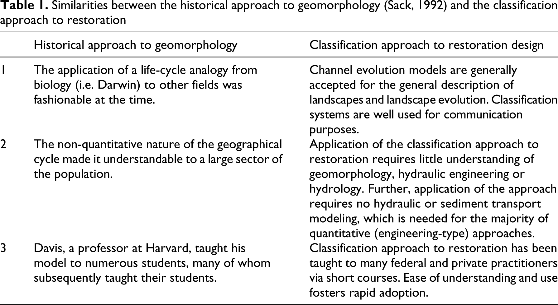
In many respects, the classification approach to river restoration encourages the adoption of the historical approach to geomorphology. The assumption that one can predict the future behavior of a landscape from its appearance is strikingly reminiscent of Davis' cycle of erosion. There are several explanations for why restoration design has returned to something evocative of the historical approach, and this can best be explained by noting the similarities between the popularity of the Davisian approach to geomorphology during the first half of the 20th century and the popularity of the classification approach to restoration today (Table 1). First, at the time of Davis, conceptualizing landscape ‘evolution’ was consistent with the burgeoning of evolution research in many sciences following the work of Darwin in biology. Similarly, classification approaches have been and continue to be common in geomorphology (e.g. Kondolf et al., 2003; Montgomery and Buffington, 1997; Simon, 1989). Second, Davis' model of the cycle of erosion was intuitive, much more so than the highly mathematical approach of Gilbert. Indeed, despite its abandonment by the majority of geomorphologists since the 1950s (Sack, 1992), Davis' conceptualization of landscape evolution remains in many introductory textbooks because of its pedagogical utility and simplicity (e.g. Ritter, 2003), while Gilbert’s work only appears in advanced texts (e.g. Johnson, 1970). Similarly, the classification approach to channel design is intuitive and is amenable to conveyance via short courses. In particular, it stands in sharp contrast to the time and effort needed to develop the analytical and mathematical abilities to conduct a modeling-based channel design, many of which are only undertaken by engineers or geomorphologists with advanced degrees. Finally, both Davis' nomenclature and Rosgen’s classification system spread quickly. Davis' position as a professor at a prestigious university gave him considerable stature as an authority on geomorphology and landscape processes, and allowed him to train several generations of future geomorphologists, thus propagating his view of geomorphology. Similarly, because the classification approach can be taught quickly via short courses to a wide range of people with or without technical backgrounds in river processes, and because this approach has been adopted or even required by many government agencies, it has spread rapidly as the accepted approach to channel design.
Similarities between the historical approach to geomorphology (Sack, 1992) and the classification approach to restoration
However, there are crucial differences which should be noted between Davis' view of geomorphology in the early 20th century and the classification approach to river restoration today. First, while Davis' approach was accepted by the scientific community as a valid approach to geomorphology for almost 50 years, the classification approach to restoration design has been criticized since its first introduction in much of the peer-reviewed scientific literature (Juracek and Fitzpatrick, 2003; Kondolf, 1995; Kondolf et al., 2001; Miller and Ritter, 1996).
Second, while Davis' approach to geomorphology represented a scientific pursuit limited mainly to landscape descriptions, river restoration affects public waterways and thus has significant economic and safety implications. Finally, Davis' deterministic approach to the evolving landscape operated over geologic time. Thousands of years were required for erosional processes to do their work and, hence, time to Davis was the ultimate driver. Rosgen’s classification system and predictive/prescriptive use of the system operates in streams modified by humans, with response rates that have been condensed from geologic time to decades or even years. While Davis' prediction could absorb local variation or contingency over time, the contracted temporal scale of the rivers in which classifications are applied to channel design work amplifies any mistakes or incorrect predictions.
IV Discussion and conclusions: future of restoration approaches
Conflicting viewpoints on restoration designs will continue to become significant given the high cost of and public exposure to many restoration projects, particularly those in urban settings (Palmer et al., 2004). At present, there is insufficient evidence to suggest that either design approach has led to greater numbers of project failures, for while the classification approach has had notable failures, it has also had some successes (Lave, 2009; Malakoff, 2004; National Research Council, 1992). In addition to the issue of success or failure of the two approaches is the issue of promoting the evolution and development of the field of river restoration. Agencies' requirement of a particular approach to restoration design (i.e. classification) will potentially limit creative, alternative approaches to restoration thinking. Indeed, it is particularly important at this early stage of the science of river restoration to consider ways to maximize the development and evolution of this emerging discipline.
The history of Davis and Gilbert within the discipline of geography leaves us with some lessons as we move forward with stream restoration. (1) Historical and atemporal approaches both contribute to the understanding of landscape and process. Dismissal of one approach handicaps the other. (2) Classification and process approaches are needed both to understand the landscape and to allow productive dialogue within the scientific community. (3) Caution should be exercised before retiring old or ‘unscientific’ (not involving hypothetico-deductive reasoning) approaches. (4) A narrative approach, which involves broad description and consideration of past structure is needed in balance with numerical methods. The conflicting approaches to river management discussed here are not new. Well before river restoration became a prominent subject, Schumm (1972) acknowledged a continuing problem: the description and classification of rivers by geomorphologists has not provided the engineer with useful information that can be applied to river control problems. On the other hand, the concern of the engineer with the relatively rapid response of a river to the influence of structures has caused him to lose sight of the fact that the river has a history. (Schumm, 1972: 2)
Coupled methods may end up along Richards' ‘spectrum of appropriate methodologies' (Richards, 1994: 279–280) where one approach is more appropriate in certain situations. For example, in urban areas with fixed infrastructure, streams may have to be designed to fit certain widths or depths with maximum stability. In this case, it may be more appropriate to use a predominately process-based engineering approach. In a rural stream where the system can adjust to multiple variables and where there is less possibility of negative impact if the channel changes over time, a design using a classification-based approach (NCD or similar) coupled with engineering models may make more sense.
Rather than adopt or abandon a single form of channel design, it is important to recognize that it is the accumulation and progression of ideas in science that is inherent to its value. The science of restoration cannot continue to develop, however, when limitations are placed upon the methods from which designers can choose (recall the requirements of the Montana Departments of Fish, Wildlife and Parks, 1998). Indeed, work in both stable and severely altered environments (such as urbanized systems with altered hydrology and sediment transport regimes) requires careful application of analog, empirical, and analytical restoration approaches in order to approximate appropriate channel conditions. While preliminary and important insight can be gained through the application of classification systems, adequate analysis for quantitative restoration design requires analysis well beyond their current scope. Thus, the dependence on, or requirement of, a specific design approach precludes the ability of river restoration to develop.
Most river restoration designers will acknowledge an inherent ‘art’ of river restoration (Newbury, 1995). However, this ‘art’ is not static, in that it is not merely on display. Rather, restoration designs must prove functional hydraulically, geomorphically, and biologically. Restored rivers affect the general public from both an economic (e.g. public funding) and a safety (e.g. instability or flooding) standpoint. These aspects of restoration should push designs past art and into applied science, and thus require restoration as a science to balance specific process geomorphic science with a thorough historical geomorphic understanding more common to those with broad training. It is clear that multiple viewpoints and approaches converge towards a more thorough understanding of a system and will increase the probability of successful restoration. This will most likely include system-wide observation and classification married to numerical process modeling.
Footnotes
Funding was provided in part by NSF Geography and Regional Science Program.
Acknowledgements
Discussions with Nick Wallerstein and Karin Boyd were the impetus for the ideas presented here, and discussions of the history of geomorphology and ecology with Jon Harbor, Jeff Muehlbauer, and Jon Duncan helped refine many of the arguments. Matt Kondolf and David Sear provided insightful comments on an earlier version of this paper.