
Abstract
This progress report discusses the lineage of atmospheric rivers (ARs) research, focusing on the transformation of the topic from an important regional atmospheric feature along the U.S. West Coast to a globally relevant driver of extreme hydrometeorological events. As the AR literature has advanced, so has the regional expanse covered, initially expanding into the Central U.S. and Europe. Recently, new, emerging regions are being explored in the AR literature such as the high latitudes, New Zealand, China, North Africa, and the Middle East. The literature on the impact of AR-driven hydrometeorological events on land surface processes (e.g., landslides and avalanches) and water resources is also rapidly developing. This progress report seeks to expose the broader physical geography discipline to the global relevance of ARs and promote new applied research frontiers at the intersection of ARs and those processes studied by physical geographers.
1. Origins of atmospheric river research
In 1992, a case study was conducted to determine the existence of tropospheric rivers, and the findings identified the presence of filamentary structures in satellite-derived daily global tropospheric water flux values (Newell et al., 1992). Thirty years later, the term atmospheric river (AR) appears in hundreds of peer-reviewed journal articles a year. The foundational research in ARs began over the Pacific Ocean where ARs were initially linked to bomb cyclogenesis (Zhu and Newell, 1994). The improvement in satellite-derived measurements of tropospheric moisture enabled researchers to understand the spatial distribution and extent of ARs. As global observational and model data have substantially improved over the last 30 years, so has the understanding of the global extent of ARs and its prevalence as a primary driver of extreme hydrometeorological events and subsequent land surface processes.
As the AR literature has grown exponentially over the last 10 years, so has the debate over what is an AR. As of June 2021, a Scopus search for the term(s) “atmospheric river(s)” in abstracts, titles, and keywords yields 600 peer-reviewed publications, with 94% being published since 2011 and 76% published since 2016. The topic of defining an AR has led to enough debate that it was the focus of several panel discussions, workshops, and conference town halls in order to try to reach some consensus on a definition (Ralph et al., 2017a; Ralph et al., 2018). This culminated with an entry into the American Meteorology Society’s Glossary of Meteorology which defines ARs as, “a long, narrow, and transient corridor of strong horizontal water vapor transport that is typically associated with a low-level jet stream ahead of the cold front of an extratropical cyclone” (Ralph et al., 2018). While there are several comprehensive review articles that discuss atmospheric rivers, this progress report will focus on the evolution of the metrics and definitions used for ARs and how the expansion of the AR literature into new spatial domains has contributed to that evolution. Lastly, this report will highlight the new frontiers of the AR literature as it pertains to applications of interest to the broader physical geography discipline. At the time of the writing of this progress report, Scopus indicates that of the 600 publications on atmospheric rivers, none were published in a Geography focused journal. The aim of this report is to expose the discipline of geography to ARs and the potential impacts to human, economic, and physical systems commonly investigated by geographers to help facilitate future research.
2. Regionalization of atmospheric river metrics and detection
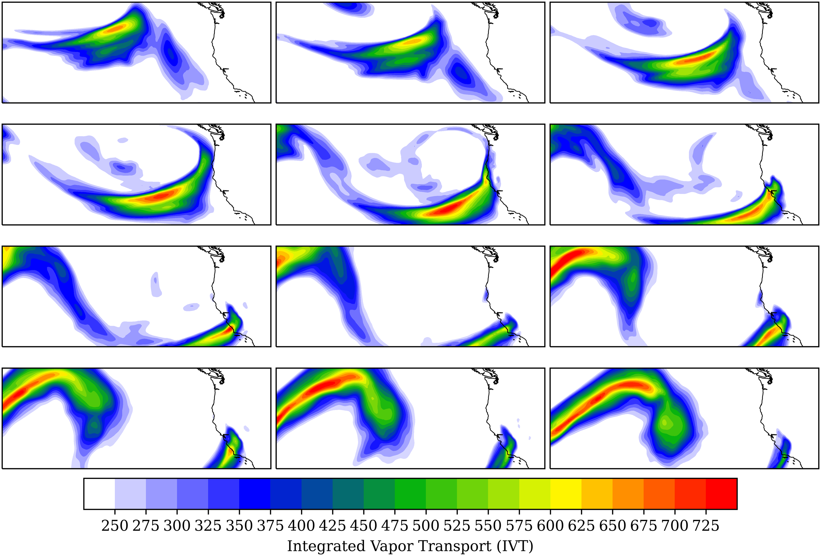
Due to the foundational AR literature being rooted in the Pacific Ocean domain, most of the early metrics and research for determining the presence of an AR were tailored to detecting Pacific (West Coast U.S.) ARs. These ARs tend to be high-impact events, leading to significant flooding as the ARs intersect significant topography in California, Oregon, and Washington. Figure 1 shows a particularly high-impact AR event from January 2021 that led to significant flash flooding and mudslides in California. The rainfall from these ARs provides significant portions of the yearly water budget. The ARs in this geographic domain are the best understood and well researched. The development and evolution of the scientific literature on these Western U.S. ARs provide a template for future AR research in new geographic domains. The development of such literature tends to follow four stages: (1) Investigating the prevalence of ARs in a study domain, (2) determining the variability of AR strength and frequency, (3) understanding the role ARs play in extreme hydrometeorological events (e.g., flooding), and (4) exploring how ARs impact water resources, land surface processes, and human systems. Time evolution of a high magnitude AR impacting the U.S. West Coast in January 2021. Contours represent integrated water vapor transport (underlying specific humidity and wind data are from ERA5 reanalysis).
West Coast AR literature represents the only study domain that has completed all four of these steps. Readers interested in a contemporary, comprehensive review of West Coast U.S. and Pacific ARs should consult (Payne et al., 2020). The broader AR literature has initiated new investigations into other geographic regions to begin the development of the literature. Some regions, such as Europe, are trending toward the latter stages of literature development. However, emerging regions, such as the Middle East and North Africa, represent spatial domains that are beginning the development of the AR literature at stage 1.
The more recent trend in AR studies is to use integrated vapor transport (IVT), typically from the surface to 300 hPa, to detect the presence of an AR, using a threshold of 250 kg m−2s−1 to detect the lateral boundaries of the feature (Dacre et al., 2015; Ralph et al., 2019; Ralph and Dettinger, 2011; Rutz et al., 2014). Despite IVT often being analyzed up to 300 hPa, ARs are primarily confined to the lowest 3 km of the troposphere, with only 5% of the moisture transport occurring above 500 hPa (Ralph et al., 2017b; Ralph et al., 2018).
The 250 kg m−1s−1 IVT threshold appears to be first used in Rutz et al. (2014), which was focused on Pacific Ocean ARs and denotes a time period where the AR literature pivots from largely using integrated water vapor (IWV) or precipitable water (PW) to IVT as the preferred metric for measuring ARs for most applications. This pivot toward IVT from other metrics such as IWV and PW is driven by the acknowledgment that moisture advection within ARs is a defining attribute and thus a function of the wind field. IVT is a function of the u- and v-winds as well as specific humidity and thus provides a quantitative representation of both the thermodynamic and kinematic forcings of ARs. A typical representation of IVT is
Studies adopting the 250 kg m−1s−1 threshold are often situated in a domain with relatively low background moisture (e.g., Pacific Ocean). Studies in higher water vapor regimes have adopted stricter thresholds for IVT, including studies in the southeast U.S. where an IVT threshold of 500 kg m−1s−1 has been implemented (Mahoney et al., 2016). The use of higher thresholds in these high low-tropospheric moisture domains is justified with research that shows maximum IVT has a median value of 367.8 kg m−1s−1 across central and eastern U.S. (Lavers and Villarini, 2015). Additionally, the 95th percentile for IVT in a similar domain over the Eastern U.S. was shown to be 552 kg m−1s−1 (Teale and Robinson, 2020).
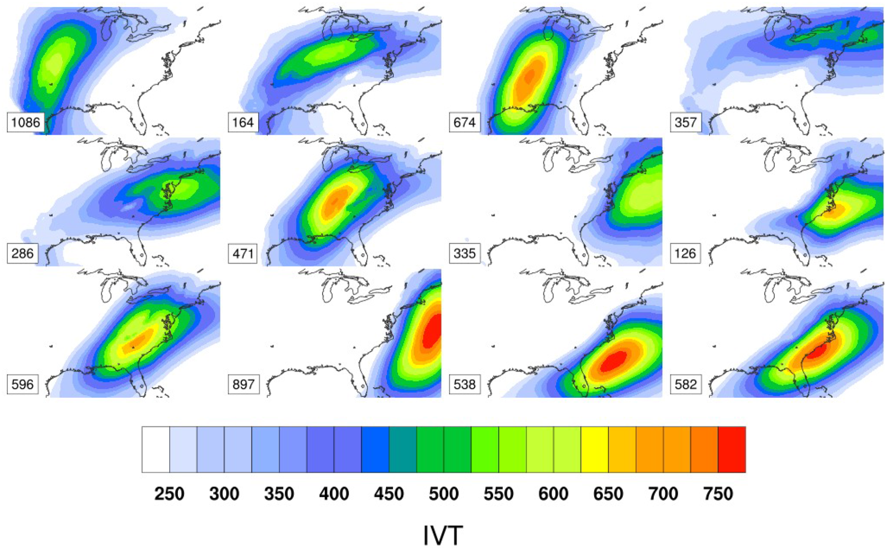
To further illustrate the importance of accounting for background moisture, and the climatology of IVT in a study location, an analysis of ARs in eastern and central U.S. using different IVT thresholds are presented here (Figures 2 and 3). Using a 12 node self-organizing map (SOM) approach with IVT derived from 6-hourly ERA5 specific humidity and u- and v-winds from 1979 to 2020, ARs were identified using two thresholds. Figure 1 follows traditional West Coast U.S. metrics where ARs are defined using an IVT threshold of 250 kg m−1s−1 and a contiguous length of pixels of at least 2000 km achieving the threshold (Rutz et al., 2014). Figure 2 adopts a stricter threshold accounting for increased background moisture following regional studies from the Eastern and Central U.S. (Lavers and Villarini, 2015; Mahoney et al., 2016; Teale and Robinson, 2020). Figure 2 uses an IVT threshold of 500 kg m−1s−1 and a contiguous length scale of at least 1500 km achieving the threshold. The figures also include the number of 6-hourly observations that map to each node type. When summed across all nodes for the 250 kg m−1s−1 threshold, the number of 6-hourly observations with an AR observed was 31,254 (Figure 1). This represents 50.9% of all 6-hourly observations from 1979 to 2020. When using the 500 kg m−1s−1, even using a slightly less stringent length scale, the number of total observed ARs is 6112, representing 9.9% of all 6-hourly observations (Figure 2). The SOMs for both thresholds tend to resolve similar AR “types” but the change in intensity of the ARs from Figure 2 to Figure 3 is evident. Central and Eastern U.S. atmospheric rivers from 6-hour ERA5 reanalysis when defined with a threshold of 250 kg m−1s−1 and length scale of 2000 km. The number of each AR type is plotted in each panel. The total number of observed atmospheric rivers is 31,254. Central and Eastern U.S. atmospheric rivers from 6-hour ERA5 reanalysis when defined with a threshold of 500 kg m−1s−1 and length scale of 1500 km. The number of each AR type is plotted in each panel. The total number of observed atmospheric rivers is 6112.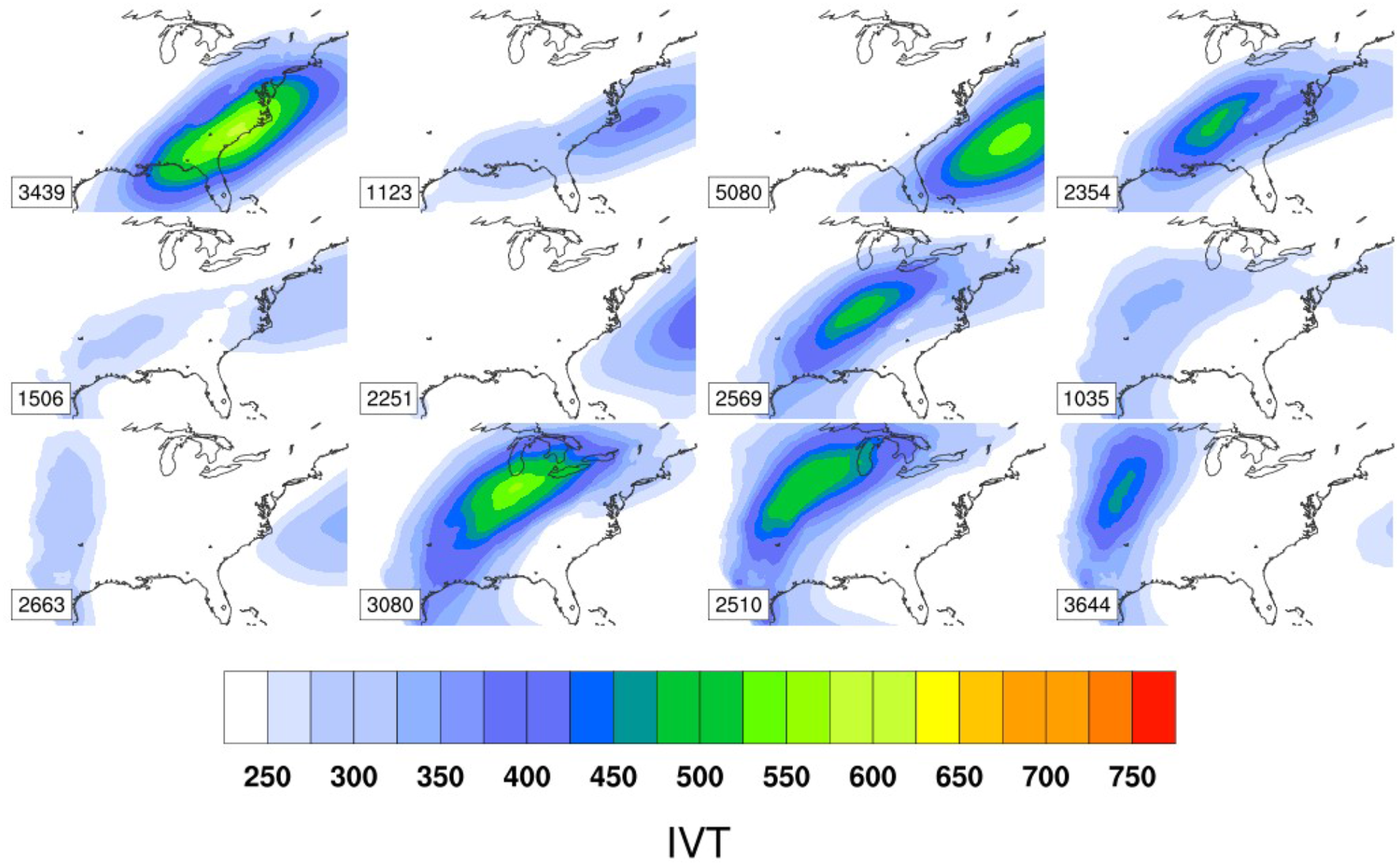
The lower threshold SOM also is resolving ARs in seemingly benign summer-time patterns. In Figure 2, node 5 (middle row, left column) occurred over 1500 times but is largely a summer-time regime representative of elevated boundary layer moisture with limited kinematic forcing. This suggests this particular IVT configuration is fairly representative of a typical summer-time background state. Referring back to the AMS Glossary of Meteorology definition of ARs, they are, “corridors of strong horizontal water vapor transport.” However, if approximately half all of the observations from 1979 to 2020 are achieving the 250 kg m−1s−1 threshold, do the features being identified represent strong transport or are they more representative of the mean state?
This exercise highlights the importance of accounting for the background flow and moisture of the study domain for AR detection research. As new regions are being explored for the presence and frequency of ARs, sufficient understanding and tuning of the background kinematic and thermodynamic environments will lead to more fruitful results. Other studies have adopted methodologies that employ anomaly-based metrics to determine the presence of an AR in an alternate attempt to account for background climate conditions (Guan and Waliser, 2015).
2.1. ARs in central U.S. and southeastern U.S.
As ARs and their links to flooding and extreme hydroclimatic events have become abundant in the literature over the West Coast of the U.S., AR research has percolated into new spatial domains. AR research in these areas explores the relationship between ARs and large-scale climate features, and the impact of ARs on regional scales. One of the first domains to be explored was the central United States. The link between the central U.S. and distant moisture sources has been recognized since the 1950s, when (Benton and Estoque, 1954) identified a strong meridional moisture flux stretching from the Gulf of Mexico through the eastern U.S. as a prominent component of North American hydroclimatology and hydrometeorology. Though the term “atmospheric river” was not applied, this seminal research identifies a low-level core of moisture transport steered northward and eastward by other atmospheric features such as the Bermuda High. Later work found that this moisture is sourced as far as the eastern Pacific, and that its transport is often enhanced by low-level jets (LLJs) (Mestas-Nuñez et al., 2007). This plume of moisture from the Central American region was later coined the “Maya Express” by (Dirmeyer and Kinter, 2009), to liken it to other ARs with colloquial names such as the “Pineapple Express” referring to ARs stretching from the tropical Pacific to western North America (Gimeno et al., 2014). Since these earlier works identifying the role of ARs in central U.S. precipitation—a vital element to agriculture and other economies—ARs have been increasingly studied in the region.
ARs occur year-round in the central U.S., contributing 20%–30% of annual precipitation in the region (Lavers and Villarini, 2015). In winter months, ARs are driven by extratropical cyclones and contribute up to 50% of winter precipitation (Lavers and Villarini, 2015). In summer months, ARs in the central U.S. are intensified by the Great Plains and Caribbean LLJs (Mestas-Nuñez et al., 2007; Moore et al., 2012). Additionally, heavy rainfall can be produced when ARs are coincident with mesoscale convective systems (Lavers and Villarini, 2015; Moore et al., 2012). Thus, ARs have been associated with regular flooding in the central U.S. (Lavers and Villarini, 2013a; Villarini, 2016). Major flood events in the central United States have also been associated with ARs (Lavers and Villarini, 2015), including the 1993 Midwest floods resulting in 48 fatalities, the 2008 floods across nine Midwestern states resulting in 24 fatalities (Dirmeyer and Kinter, 2009, 2010; Lavers and Villarini, 2013a), and the 2010 Nashville, Tennessee floods resulting in 11 fatalities (Moore et al., 2012).
Despite an increase in research regarding ARs in the central U.S., relationships between ARs and other elements of the regional climatology remain elusive. Given that: (1) ARs in the central U.S. can be related to the Great Plains LLJ (Mestas-Nuñez et al., 2007; Moore et al., 2012), (2) the Great Plains LLJ is a determinant in whether convection and precipitation occurs preferentially over dry or moist soils (Ford et al., 2015), and (3) convection is a magnifier of AR precipitation magnitude (Lavers and Villarini, 2015; Moore et al., 2012), one may question the role of ARs in interactions and feedbacks between soil moisture and the atmosphere.
Mahoney et al. (2016) demonstrate that ARs can be detected against the high background IWV of the southeastern U.S., and that ARs are associated with heavy precipitation in the southeastern U.S. in non-summer months. Subsequent research shows that ARs are relatively frequent in the southeastern U.S., particularly in the non-summer months, and are steered inland by a variety of atmospheric conditions, including midlatitude cyclones, the Great Plains and Caribbean LLJs, and the Bermuda High (Debbage et al., 2017). ARs flowing over the southeastern U.S. have been associated with societal hazards, including the severe flooding in Nashville, Tennessee in 2010 (Moore et al., 2012) and flooding in the southern Appalachian Mountains (Miller et al., 2018).
Relationships between large-scale atmospheric circulation and ARs in the central and southeastern US have been assessed. For instance, wave patterns forming a trough over the central US and a ridge over the eastern US maintain ARs from the Gulf of Mexico through the central US (Nayak and Villarini, 2018). Similarly, the North American Subtropical high (NASH) or Bermuda High in the western Atlantic also supports and steers strong meridional moisture transport through the southeastern and central US (Debbage et al., 2017; Nayak and Villarini, 2018). Such relationships can also be observed between AR frequency and large-scale atmospheric modes. The Pacific North American (PNA) pattern has been associated with moisture fluxes emanating from the Caribbean and Gulf of Mexico (Mestas-Nuñez et al., 2007), and has been shown to have a strong negative correlation with ARs in the central United States in the fall and winter months (Nayak and Villarini, 2018). Positive correlations exist between the Arctic Oscillation (AO) and the North Atlantic Oscillation (NAO) and ARs in the central United States (Nayak and Villarini, 2018).
2.2. ARs in Europe
The influence of ARs on precipitation in Europe was first identified in Stohl et al. (2008), which linked precipitation in Norway to tropical and subtropical sources via post-tropical cyclones. Subsequent studies have shown that ARs landfalling in western Europe are strongly associated with extratropical cyclones (Lavers and Villarini, 2013b, 2015). While ARs can occur in any season in western Europe (Eiras‐Barca et al., 2016), much of the heavy precipitation and significant flooding associated with ARs occurs in the winter months (Kirien et al., 2020; Lavers and Villarini, 2013a, 2013b, 2015). This seasonality of AR-related heavy precipitation is not spatially uniform across Europe. For instance, Ramos et al. (2018) demonstrate that the strongest association between extreme precipitation and AR events in Portugal occurs in the transition seasons, finding that April-May period experiences strong ARs from late-season extratropical cyclones, and AR-related precipitation in September is enhanced by warm SSTs and mesoscale convective systems.
Similar to western North America, AR precipitation in Europe is enhanced by topography, with AR precipitation maxima along the topography of Norway, the Alps, the Pyrenees, and other areas of complex topography (Lavers and Villarini, 2013b, 2015; Stohl et al., 2008). While mountains generally have a blocking effect on ARs, regardless of region, the geography of the mountains in Europe allow ARs to penetrate further inland than in North America, with ARs being detected as far inland as Poland, Germany, and Lithuania (Lavers and Villarini, 2013b, 2015).
A major control on landfalling location of ARs in western Europe is the phase of the North Atlantic Oscillation (NAO), with ARs generally steered into southern (northern) Europe in the negative (positive) phase of the NAO (Eiras‐Barca et al., 2016; Lavers and Villarini, 2013b; Stohl et al., 2008). This relationship between AR landfalling locations and local weather features was supported and expanded upon by (Pasquier et al., 2019). Recent work has shown that unusual weather patterns can support ARs or AR-like features extending from across Africa and the Mediterranean to make landfall in the Italian and western Mediterranean coasts (Davolio et al., 2020; Lorente‐Plazas et al., 2020). While these events are rare, their interaction with the coastal topography can cause significant flooding (Lorente‐Plazas et al., 2020).
The inland trajectory of an AR influences its effects, in Europe and elsewhere. The effects of European ARs, including heavy precipitation and flooding, are diminished with distance from the Atlantic coast (Lavers and Villarini, 2013b, 2015; Ramos et al., 2015, 2018). However, not all ARs are associated with heavy precipitation and flooding (Eiras‐Barca et al., 2016). Hegdahl et al. (2020) show that in some cases, the magnitudes of AR-related floods are more strongly influenced by snow, soil moisture, and other hydrological initial conditions than by meteorological conditions. Because of the importance of these antecedent conditions, the location and trajectory of ARs is exceedingly important in anticipating impacts.
2.3. ARs in high latitudes
The presence and impacts of ARs have been researched in high-latitude locations, particularly in Greenland and Antarctica, where they have been shown to have a substantial and nuanced impact on precipitation and ice sheet mass balance. Due to the precipitation they deliver, ARs have been associated with gains in ice sheet mass balance in Greenland, particularly in non-summer months (Mattingly et al., 2018). In east Antarctica, ARs contribute substantially to gains in the surface mass balance (Gorodetskaya et al., 2014; Wille et al., 2021). ARs are also drivers of extreme precipitation events that increase surface height in west Antarctica (Adusumilli et al., 2021). However, ARs are also, if not more frequently associated with melt events in the cryosphere. While ARs contribute to snow accumulation in east Antarctica, they generally are associated with melting in west Antarctica (Wille et al., 2021).
Significant melt events in Greenland have also been associated with ARs, including the melt events of 2012 (Bonne et al., 2015; Mattingly et al., 2018; Neff et al., 2014) and 1889 (Neff et al., 2014). This is in part due to precipitation processes of the ARs, including latent heat release (Bozkurt et al., 2018). Additionally, the high moisture content of ARs is associated with anomalously high downward longwave radiation, contributing to warming and melt events (Wille et al., 2019). The high moisture content of ARs also supports melt events through reduction of radiative cooling (Hegyi and Taylor, 2018; Wille et al., 2019). This reduction in radiative cooling is related to Arctic sea ice declines, as the reduction in nighttime radiative cooling inhibits sea ice refreezing overnight (Hegyi and Taylor, 2018). ARs can also be associated with local events in high-latitude regions. For instance, rapid warming and melt due to an AR-triggered foehn has also been observed in continental Antarctica (Bozkurt et al., 2018).
Similar to other regions, relationships between high-latitude ARs and teleconnections are being investigated. In the northern high latitudes, AR characteristics are related to the NAO (e.g., (Mattingly et al., 2018; Neff et al., 2014; Pasquier et al., 2019)) and to the AO (Neff et al., 2014). ARs in Antarctica have recently been linked to the Southern Annular Mode (SAM). The SAM represents an oscillation of atmospheric pressure between Antarctica and the southern midlatitudes and is a primary forcing mechanism on storm tracks in the Southern Ocean (Spensberger et al., 2020; Thompson and Wallace, 2000). ARs in Antarctica are more frequent when the SAM is in its positive state (Wille et al., 2021).
2.4. Emerging regions
Studies establishing the relationship between ARs and other regions are emerging and numerous. For instance, recent studies have indicated that ARs are not only a non-negligible part of the regional climate system in Iran but also that ARs approach the region from a variety of trajectories and origins (Esfandiari and Lashkari, 2020a, 2020b; Salimi and Saligheh, 2016). The importance of ARs across the Middle East and North Africa (MENA) more broadly has also been established (Akbary et al., 2019). ARs in this domain have been shown to have a wide variety of source regions, including the North and South Tropical Atlantic Ocean and on rare occasions, the Arabian Sea (Akbary et al., 2019).
Research in MENA represents a body of AR literature advancing toward stages 2 or 3 in development. Research on ARs have initiated in other emerging areas such as New Zealand (Little et al., 2019), Australia (Finlon et al., 2020; Rauber et al., 2020), the Asian-Australian monsoon region (Wu et al., 2020; Ye et al., 2020), northeastern United States (Teale and Robinson, 2020), northeastern North America (Hsu and Chen, 2020), southern South America (Garreaud, 2013; Viale et al., 2018), southern Africa (Blamey et al., 2018; Ramos et al., 2019), and southwest India (Lyngwa and Nayak, 2021). In most of these regions, the literature is currently in the earliest stages of development where the prevalence of ARs is being investigated. These emerging regions represent domains with great potential for future research as the literature progresses toward the latter stages of development where impacts are accessed.
3. AR impacts on landscapes and water resources
The majority of applied AR research investigates linkages between ARs and pluvial conditions (e.g., Corringham et al., 2019; Dettinger et al., 2011; Eiras‐Barca et al., 2016; Hirota et al., 2016; Kim et al., 2013; Kirien et al., 2020; Lavers and Villarini, 2015; Leung and Qian, 2009; Mahoney et al., 2016; Moore et al., 2012; Nayak and Villarini, 2018; Neiman et al., 2008, 2011; Pasquier et al., 2019; Ralph and Dettinger, 2011). Using a slightly different framing, research has established ARs role as “drought busters” (Dettinger, 2013) and a contributor to drought through lower frequencies of ARs (Dettinger, 2016). ARs are shown to account for 85% of the multi-year precipitation variance in California (Dettinger, 2016). Research on extreme precipitation and its linkages to ARs has been investigated on nearly every continent. While many AR review papers focus on linkages to flooding, this progress report will focus on advances in other applications. One of the new frontiers of AR research is its application to physical landscape processes, most notably, its application to land surface processes and water resources.
3.1. ARs and landslides
ARs have also been identified as the principal forcing for a range of surface processes including avalanches, post-fire debris flows, and landslides. The linkage between these surface processes and ARs is through the production of intense rainfall over long durations. AR-induced landslide literature has been focused primarily in California where landslides can result in extensive property damage and fatalities (Biasutti et al., 2016; Cordeira et al., 2019; Stanley et al., 2020). Most of the focus of these studies is on shallow landslides involving mobilized soils during or after a heavy rainfall event (Cordeira et al., 2019; Oakley et al., 2018). A 142-yr record of landslides in the San Francisco Area indicates that 82% of the landslide days were linked to AR-like features (Cordeira et al., 2019). Similarly, a 22-yr study in California showed that 60–90% of shallow landslides coincide with atmospheric rivers (Oakley et al., 2018). Landslides are also important hazards in other mountainous areas; thus, the AR-landslide relationship has begun to be investigated in other regions, including the Southeast U.S. (Miller et al., 2019).
ARs have also been identified as triggers for other landscape processes including serving as a trigger for cool season post-fire debris flows in southern California, where 68% of post-fire debris flows were associated with an AR event with IVT ≥ 90th percentile (Oakley et al., 2017). Similarly, ARs have been linked to avalanches in the Western U.S. where ARs help initiate avalanches and can be attributed to 31% of avalanche fatalities in the region (Hansen and Underwood, 2012; Hatchett et al., 2017). Avalanches in coastal mountain ranges had the highest percentage of avalanche fatalities coinciding with ARs (31–65%) while tapering off over intermountain (25–46%) and continental (<25%) regimes (Hatchett et al., 2017). Cold season ARs have the potential to produce significant snowfall events and be a primary contributor to the annual snowfall budget. In the Southern Alps of New Zealand, ARs have been linked to 60–70% of extreme snowfall events (Porhemmat et al., 2021). Across the Sierra Nevada, ARs have been shown to generate 4 times the daily snow water equivalent (SWE) compared to non-AR storms and contribute ∼30–40% over the total winter SWE (Guan et al., 2010, 2013).
3.2. ARs and water resources
AR applications in the broader field of water resources have been growing in recent years. Early research focused on flooding, and highlighted that ARs are responsible for >95% of the insured flood losses along the Pacific Coast of the U.S. (Corringham et al., 2019). The intensity and duration of the ARs has been linked to an exponential increase in flood damage as well (Corringham et al., 2019). ARs occurring as rain-on-snow events have been shown to increase streamflow discharge and flooding in the Sierra Nevada Mountains (Guan et al., 2013, 2016). A growing body of evidence suggests that ARs are a dominant forcing mechanism on snowpack across the Western U.S. (Goldenson et al., 2018; Guan et al., 2013; Hansen and Underwood, 2012; Huning et al., 2017). Similar relationships have been noted in New Zealand (Little et al., 2019) and Antarctica (Gorodetskaya et al., 2014).
As the linkages between ARs and precipitation extremes became apparent, AR forcings to other natural and human systems have been explored. A study investigating levee breaks in the Central Valley of California found that 81% of all breaks were associated with ARs (Florsheim and Dettinger, 2015). The large, rapid inputs of AR-induced freshwater into reservoirs, lakes, and other water bodies and the cascading impacts are an emerging area of research. In the San Francisco Bay, ARs have been shown to be a forcing mechanism for wild oyster mass mortality as ARs lower salinity with the extreme runoff they produce (Cheng et al., 2016). These low salinity events have also been linked to broad community state changes across a wide range of species (Chang et al., 2018).
4. The future of regional AR studies
This progress report has highlighted the propagation of the AR literature from its geographic origin in the Western U.S. to regions around the world. While the propagation has begun in earnest, most of the non-Western U.S. research is focused on AR climatologies and better understanding the regional dynamics leading to ARs. As regional AR dynamics become better resolved, applied AR studies focusing on land surface processes, water resources, ecology, and agriculture will become more prolific. While already an area of rapid investigation, studies analyzing climate change impacts on AR strength and frequency will continue into currently underserved regions. While many studies currently focus on the presence and prevalence of ARs, new research frontiers will analyze the influence of a lack of ARs on drought and water resources. Analyses of AR periodicity on multiple time scales will be investigated to determine linkages to global oscillations. The sensitivity of AR strength and frequency to thermodynamic forcing from climate change coupled with the propensity of high-impact flooding events to be linked to ARs, and the rate of AR publications and research is likely to further accelerate during the next decade.
Footnotes
Declaration of conflicting interests
The author(s) declared no potential conflicts of interest with respect to the research, authorship, and/or publication of this article.
Funding
The author(s) received no financial support for the research, authorship, and/or publication of this article.