
Abstract
Deevey et al.’s (1979) Mayan Urbanism: Impact on a Tropical Karst Environment combined paleo-demographic data from the Lowland Maya region, obtained from archaeological survey and test-pitting, with paleolimnological data derived from local lakes, to evaluate the environmental impacts of long-term, ancient Maya agro-engineering activities in the region. The interdisciplinary approach to studying human-environment interactions was novel at the time and paved the way for many subsequent hybrid Earth Science/Archaeology projects in the Maya area.
Keywords
I Introduction
I revisit Deevey et al.’s (1979) “Mayan Urbanism: Impact on a Tropical Karst Environment,” >40 years after it was published, to review how the study was done, highlight its major findings, and place the paper in historical context with respect to investigations of long-term human-environment interactions in the Maya Lowlands. Research for the publication, now cited nearly 400 times, was carried out as part of the Central Petén Historical Ecology Project (CPHEP), under the direction of Edward S. Deevey Jr. (Figure 1). The CPHEP was not the first to employ Earth Science data to address questions about past environmental conditions on the Yucatán Peninsula or ancient Maya impacts on the landscape (Cowgiil and Hutchinson 1966; Covich 1976). It was, however, the first large project in the Lowland Maya region that was truly interdisciplinary, in that from its inception, the CPHEP brought together researchers from multiple disciplines to explore links between ancient Maya populations in northern Guatemala, reconstructed from archaeological survey, and paleoenvironmental changes inferred from lake sediment cores. The ultimate goal of the project was to generate quantitative measures of prehistoric, human-caused environmental strain. Photo of Edward S. Deevey Jr., taken by Brian Deevey, ca. 1981, Gainesville, Florida.
The Historical Ecology of the Maya Area project began in 1972. Many emerging environmental issues of the 1960s and 1970s, for example, soil degradation, pesticide contamination, and cultural eutrophication of inland waters by sewage and agricultural fertilizer runoff, likely influenced the research design that was developed to investigate long-term Maya-environment interactions. At the same time, Maya archaeology was shifting focus, from study of monumental architecture and elite burials, to addressing questions about commoner subsistence strategies and lifeways in the lowland tropics. Furthermore, the so-called “Classic Maya Collapse,” then as now, was a topic of immense interest and great debate (Cowgill 1964; Sabloff and Willey 1967; Sabloff 1971; Culbert 1973). Questions to be addressed by the collaboration between social and natural scientists included: (1) what was the trajectory of Maya population growth through time, and what were the environmental consequences of Maya agricultural and engineering activities? (2) did overexploitation of the environment play a role in Terminal Classic cultural disintegration? (3) how did the environment respond to regional depopulation after the “collapse”?
The geographic focus for the combined archaeological/paleolimnological study was the low-lying Petén Lake District in northern Guatemala, a karst region that constitutes the southern extent of the Yucatán Peninsula. The “haystack-hill” topography, covered largely by tropical dry forest, possesses surface limestones of Cretaceous and Tertiary age that contain localized deposits of dolomite and gypsum. Inter-watershed differences with respect to quantities of these minerals gave rise to inter-lake differences in ionic composition of the waters, that is, the relative concentrations of dissolved Ca++, Mg++, Na+, K+, HCO3-, SO4--, and Cl−, as well as total ionic strength (Deevey et al., 1980). The Petén lakes, aligned east-west along a system of en echelon faults, were formed by a combination of tectonic and solution processes. The waterbodies have steep-sloping north shores and gently sloping south shores, and most display “conical” morphometry (Figure 2). Local watersheds were optimal locations for ancient human settlement. The lakes provided a reliable source of water year-round, in this region characterized by highly seasonal rainfall, and supplied abundant protein in the form of apple snails, fish, turtles, crocodiles, and aquatic birds. Twin Lakes Yaxhá and Sacnab, and their respective drainage basins, were the main focus of the Deevey et al. study. Additional paleoenvironmental information was obtained from the sediments of Lake Quexil, which lies ∼47 km to the WSW. Bathymetric maps of Lakes Yaxhá, Sacnab, and Quexil, Petén, Guatemala. Black areas in the western basin of Lake Quexil are islands. All three lakes display cone-shaped morphometry. Lakes Yaxhá and Sacnab have steep contours along their north sides, with maximum water depths relatively close to their north shores. Lake Quexil is composed of shallow east and west basins, and a deep central basin. Fine sediments are preferentially focused into the deeper zones of the lakes, resulting in heterogeneous lake-wide sedimentation rates.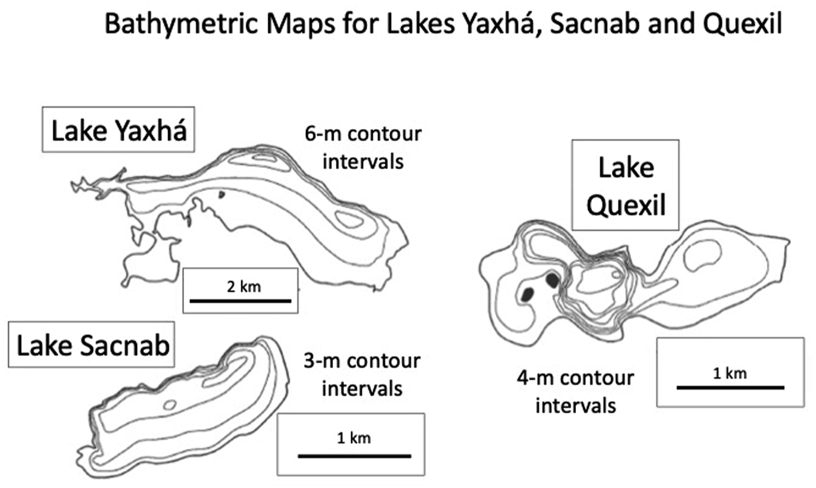
II Pre-Columbian demographic reconstruction
The Archaeology team was tasked with “reconstructing” past population densities around the study lakes. Ten randomly located transects were established, extending north-south from the lake shores. Transects were 2 km long and 0.5 km wide. In 1974, the archaeologists systematically searched for house mounds, both on and off transects. The group discovered the remains of 860 residential structures, 586 of which were within the 10 km2 of transect area, which thus sampled about 25% of the estimated ∼40-km2 hydrologic basin. Two-hundred-and-ten randomly selected structures were test-pitted, and recovered ceramics were used to assign the time of occupation to four Maya archaeological periods. Non-urban disturbed areas and population densities at the end of each archaeological period were calculated, the latter requiring assumptions about continuity of occupation and numbers of individuals per household (Haviland 1969, 1972). Both sub-basins showed exponential expansion of cumulative non-urban disturbed area, from 1000–2000 m2 km−2 at the end of the Middle Preclassic (250 BCE), to 10,000–20,000 m2 km−2 at the end of the Late Classic (880 CE). Population densities grew from 22 persons km−2 (Yaxhá) and 34 persons km−2 (Sacnab) at the end of the Middle Preclassic, to 256 and 168 persons km−2 at Yaxhá and Sacnab, respectively, by the end of the Late Classic. Although Late Classic population densities were high, the rate of growth over the previous ∼17 centuries had been surprisingly slow, ∼0.17% yr−1, indicating that the number of individuals doubled only about every 408 years. By comparison, population growth rates in some African countries exceed 3.0% today, indicating their numbers double in <23 years. In Florida (USA), the population grew from about 0.53 million inhabitants in 1900 to >21 million today, doubling more than five times in the last 120 years. The slow rate of ancient Maya population growth would have been imperceptible to anyone alive at the time.
III Paleoenvironmental inference
Lake sediments accrue in an orderly fashion and thus preserve within them a stratigraphic record of past environmental conditions in and around water bodies. Paleoenvironmental information was gleaned from long sediment cores collected in Lakes Yaxhá, Sacnab, and Quexil, using a hand-driven Livingstone-type piston corer operated from a small boat. Cores were analyzed for pollen, lithology, and element content. Developing reliable core chronologies (age-depth relations) proved especially challenging. Radiometric 14C-dating, the standard method at the time, requires large amounts of carbon-bearing material, and sediment throughout much of the Sacnab and Yaxhá profiles was dominated by inorganic clays that contained sparse datable organic material. Even in core zones with sufficient organic matter, “hard-water-lake error” (HWLE) confounded dates on bulk material. Hard-water-lake error is a problem in limestone terrains because dissolved bicarbonate (HCO3-) from the ancient bedrock in the watersheds contains no 14C, and when delivered to the lakes, can be used as a carbon source for photosynthesis by aquatic algae and higher plants. Such primary producers and the organisms that feed on them thus yield radiocarbon dates that are much older than their true age. Faced with these challenges, sediment cores were instead zoned using pollen assemblages, the rationale being that late Holocene changes in regional vegetation were driven solely by human disturbance, not climate, and that pollen sequences could thus be linked to archaeological periods and reliably correlated among sites. The only accepted 14C date was run on a piece of terrestrial wood (unaffected by HWLE) collected near the base of the 6.24-m-long Lake Quexil core (DAL 198, 8410 ± 180 BP). The early Holocene date indicated that the lake had accumulated several millennia of “pre-Maya” deposits, and thus possessed a record of the baseline, pre-disturbance forest-pollen rain (Deevey 1978). The Sacnab core (6.3 m) bottomed out ca. 4750 BP, and the Yaxhá core, despite its great length (7.3 m), penetrated only to the Late Preclassic, about 2000 BP. In the Quexil and Sacnab cores, there was some evidence of human interference with the vegetation by the middle Holocene, and all cores showed indications of pronounced forest removal by the Early Classic, ca. 250 CE. Forest was thought to have regenerated after the Postclassic period.
Average proximate composition of bulk sediments within pollen zones was determined by analyzing samples at 5–20-cm intervals for organic matter, calcium carbonate (CaCO3), iron oxide (Fe2O3), and SiO2 content, the latter figured as the mass that remained after subtraction of the other three constituents, and which was composed predominantly of montmorillonite clay. Next, accumulation rates of sediment constituents were calculated for each pollen zone. Such values are site-specific and do not necessarily reflect lake-wide accumulation rates, especially in these conical basins where sediment focusing causes spatially heterogeneous deposition. Nevertheless, stratigraphic shifts in material accumulation rates at a single core site do reflect temporal changes in the basin over time. Coring in Yaxhá failed to retrieve pre-disturbance sediments because of the high content of impenetrable, clay-rich material in the basal 6.35 m of the core. This rapidly accumulated, fine-grain material was found in all the lakes, and was given the moniker “Maya clay.” It is composed of allochthonous material, delivered by rapid soil erosion from steep slopes, following watershed deforestation. Because pre-disturbance deposits were not recovered from Yaxhá, it was not possible to determine the extent to which human disturbance had enhanced material accumulation rates above background values. At Sacnab and Quexil, such evaluations were possible and showed that maximum zonal CaCO3 accumulation rates on the lake bottoms, driven by human agro-engineering activities in the watershed, were 20 – 40 times their respective baseline values. For SiO2, that is, the “Maya clay,” human-driven accumulation rates were 32–35 times baseline values. Across all zones, organic matter fluxes were generally low and ranged only about 7-fold, with values in Maya-period deposits likely controlled largely by diagenesis (post-depositional changes), rather than production.
Phosphorus (P) in soils and sediments was a particular focus of the study. As for modern agriculture, phosphorus was a critical nutrient for Maya food production, and P removed with harvests was not resupplied to soils in sufficient quantity from soil genesis, or from the atmosphere, that is, in rainfall. Phosphorus was also of interest because it is often the limiting nutrient for primary production in inland waters, and is implicated in recent cultural eutrophication of many lakes and rivers worldwide. Because P has no atmospheric component in its biogeochemical cycle, except from aeolian dust and rare phosphene gas, all P delivered to lakes that lack surface outflows is ultimately deposited on the lake bottom, meaning that sediments in such closed-basin lakes preserve a quantitative record of P delivery to the lake through time, whereas farmers are typically interested in plant-available phosphate-P, it soon became apparent that most P in Petén watersheds was transferred to the lakes not in dissolved phosphate, but rather in particulate form, via downhill translocation. Thus, to assess P sequestration rates, that is, rates of P loss from the landscape, total P in sediments and soils was measured.
Samples were also collected over 10-cm intervals from six soil pits, three in each watershed, that had been dug close to the shores of Lake Yaxhá and Sacnab. Total P was measured in the top two intervals, in a sample from intermediate depth, and in a sample from the pit bottom. All pits displayed pronounced P concentration gradients, with uppermost soils enriched relative to soils deeper in the profiles. The overall mean soil P concentration (278 ± 243 mg kg−1) was similar to the mean value in sediments from Lakes Yaxhá and Sacnab, including the P-deficient clay-rich zones (208 ± 103 mg kg−1), suggesting that watershed soils were the major source of lake sediment. Excluding the low-P, Late Preclassic, and Early Classic zones in the Yaxhá core, 15 zones in the three lake cores showed strong positive correlations between accumulation rates of CaCO3 and SiO2 (r = 0.753, p < .001), CaCO3 and TP (r = 0.743, p < .001), and SiO2 and TP (r = 0.914, p < .001). This suggested that the three sediment constituents shared a common origin and mode of transport to the lake, that is, they were components of watershed soils and had been delivered via physical translocation.
IV Human-mediated phosphorus loading to Lakes Yaxhá and Sacnab
As cultural eutrophication became a growing environmental concern in the 1960s and 1970s, there was increasing interest in identifying sources of excess phosphorus that entered water bodies (e.g., sewage, agricultural fertilizers, and detergents), and in modeling how such loading rates were related to in-lake P concentrations and lacustrine biological responses such as phytoplankton blooms (Vollenweider 1968; Dillon and Rigler 1975). In Petén’s closed-basin lakes, net P accumulation rate on the lake bottom should reasonably approximate the P loading rate to the lake, though estimates derived from a single core site may be biased because of spatially heterogeneous sediment deposition rates. According to P loading models developed for temperate water bodies, the core-derived Late Classic and Postclassic P loading rate of 110 mg m2 yr−1 in Lake Yaxhá (mean depth = 7.4 m), would have exceeded “tolerable” levels. At Lake Sacnab (mean depth = 6.5 m), the Early Classic P loading of rate of ∼224 mg m2 yr−1 would be considered “dangerously high.” But unlike the situation today in culturally eutrophic lakes of Europe and North America, where much of the delivered P is in a form available to algae and higher plants, most of the P delivered to the Petén lakes during Maya occupation of the watersheds was bound in soil particles, and was buried on the lake bottoms without ever entering the food web (Binford et al., 1983). Furthermore, because the “Maya clay” was a poor matrix for preserving organic microfossils, had there been a positive biological response to anthropogenic nutrient loading, such evidence had likely been destroyed.
Because phosphorus loads to urbanized temperate lakes are frequently delivered from point sources, for example, via sewage outfalls or storm water drains, it is relatively easy to measure such P inputs, determine the size of the population that generated them, and calculate the average annual contribution to the P load from each person. Per capita physiological throughput of P amounts to ∼0.55 kg yr−1. Using a similar value for per capita P output (0.5 kg yr−1), Deevey et al. developed a simple model that described Maya-induced nutrient loading to Lakes Yaxhá and Sacnab
The model was “tested” by comparing calculated P outputs (kg km−2 yr−1) to Lakes Yaxhá and Sacnab for each archaeological period, using the archaeologically determined riparian Maya population numbers, to P inputs (also in kg km−2 yr−1) during each archaeological period, computed from P measures in the sediment cores. Calculated P output values are sensitive to estimates of the number of people who “contributed” P to the lake, which vary as a function of the land area around the lake deemed to be the effective P source area. Using the archaeologically derived population numbers within the 200-m contours around the lakes, most output-input points fell close to a 1:1 line, suggesting that the model reasonably described human-mediated export of phosphorus from the drainage basins to the lakes.
V Principal conclusions
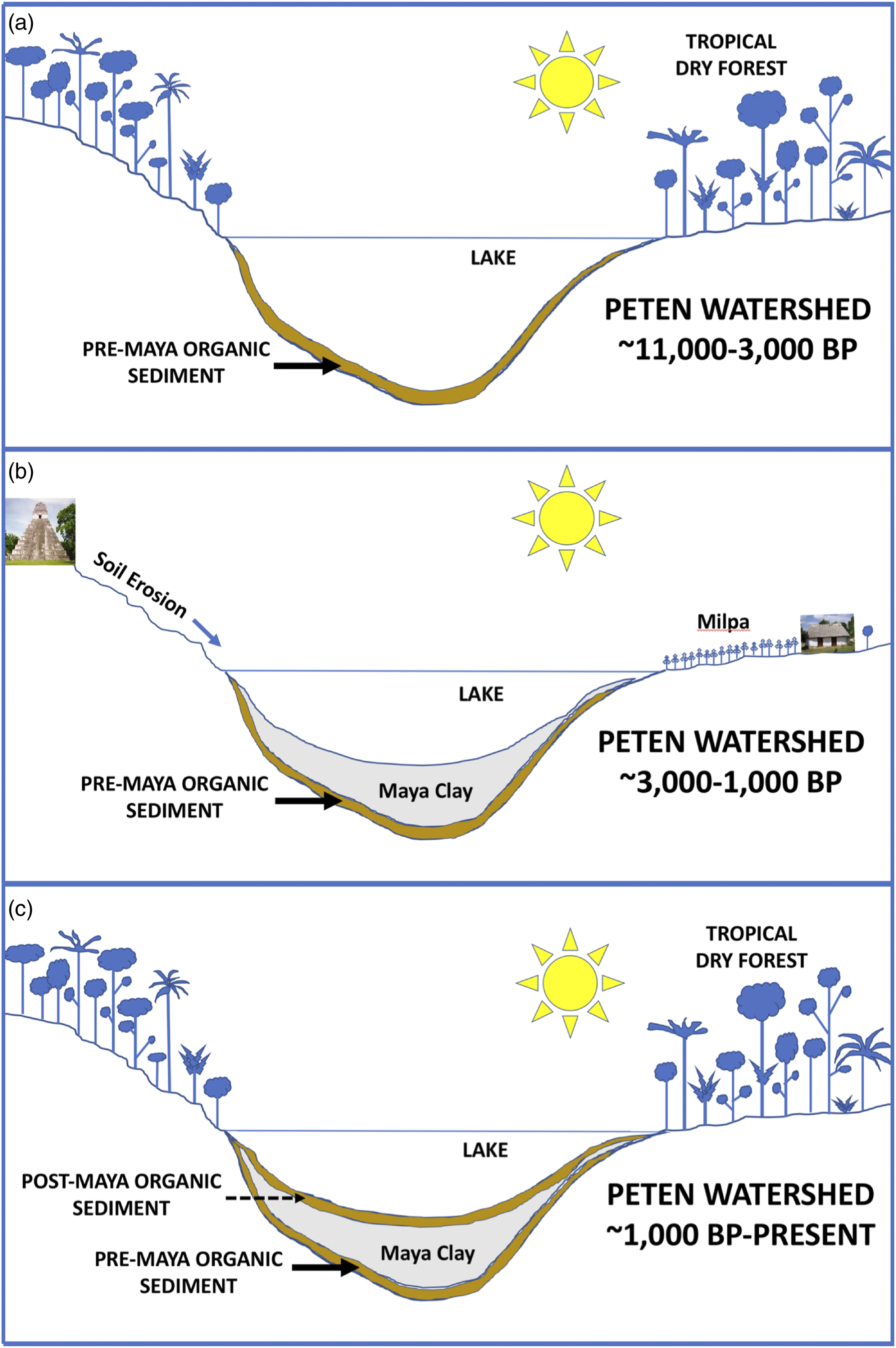
Interdisciplinary research in the Yaxhá-Sacnab basin yielded several main conclusions: 1) Maya populations in the Yaxhá and Sacnab basins grew exponentially over ∼2000 years, but very slowly, from Middle Preclassic to Late Classic times, doubling on the order of every four centuries. Such growth would have been imperceptible to local inhabitants. 2) Lowland tropical forests in the region were largely cleared by Early Classic times, but appeared to have re-grown after the Postclassic period. 3) Once the watersheds were deforested, soil erosion and consequent lake sedimentation accelerated. The rapidly accumulated material was an organic-poor, fine-grain, anthropogenic deposit referred to as “Maya clay” (Figure 3). 4) Uppermost basin soils are richer in P than deeper soils. Human-mediated export of P from the drainage basins to the lakes occurred via colluviation, and rates of P export to the lakes were consistent with per capita annual physiological throughput, that is, ∼0.5 kg. Despite high rates of total P loading to the lakes, most P was not bioavailable and bypassed the food web en route to the sediment. 5) Environmental strain from soil nutrient depletion, caused by deforestation and consequent soil erosion, apparently had little effect on human population expansion, at least until the Late Classic. Simple cartoon model of Holocene changes in vegetation (inferred from pollen) and sedimentation in watersheds of Petén, Guatemala. (a) Following the cold, dry late Pleistocene, tropical dry forest became established rapidly in the region at the onset of the Holocene, associated with warmer and wetter climate. Such forest persisted for 7–8 ka. Pre-Maya sediments accumulated slowly and had relatively high organic matter content. (b) Maya agro-engineering activities were responsible for widespread deforestation and consequent soil erosion. The ∼2000-year period of occupation was responsible for rapid accumulation in the lakes of inorganic, fine-grain sediment, sometimes referred to as “Maya clay.” Phosphorus bound in soil particles was also transported to the lakes, but largely bypassed the lacustrine food web prior to deposition on the lake bottom. (c) Following the Terminal Classic period, dramatically reduced ancient Maya population in the region led to re-establishment of tropical dry forest and soil stabilization. Sediments deposited over the last millennium again displayed higher organic matter content. For interpretation of the references to colours in this figure legend, refer to the online version of this article.
VI Revisiting Deevey et al. (1979) with 20-20 hindsight
Here I briefly discuss several potential sources of error in the Deevey et al. (1979) study, some of which were associated with faulty assumptions or limitations of methods used at the time. New technologies, developed in the last 40 years, have facilitated similar studies and will continue to do so going forward. The inability to obtain reliable radiocarbon dates on the Yaxhá and Sacnab sediment cores has been surmounted by the advent of AMS 14C dating, which enables analysis of minute terrestrial organic remains in the “Maya clay” and avoids the problem of HWLE (Rosenmeier et al., 2002a; 2002b). Reliance on pollen for “archaeological dating” of the cores was predicated on the understanding that the major features of all pollen diagrams from the region were “imposed by human disturbance of vegetation, not by climatic changes.” This assertion must be reconsidered in light of subsequent studies of lake cores (Hodell et al. 1995, 2005; Curtis et al., 1996; Evans et al., 2018) and speleothems (Medina-Elizalde et al. 2010; Medina-Elizalde and Rohling 2012; Kennett et al. 2012) that revealed climate variability in the Maya Lowlands during the period of ancient occupation, including episodes of severe, protracted droughts. Nevertheless, it is likely that Maya-mediated deforestation overwhelmed any signal from relatively shorter-term climate fluctuations, whereas forest regrowth in the Yaxhá and Sacnab watersheds was originally thought to correspond to the post-Maya period, that is, after the Postclassic, studies of pollen in well-dated cores from lakes elsewhere in Petén suggest that reforestation occurred earlier, after the Terminal Classic (Leyden 1987), and required between 80 and 260 years (Mueller et al., 2010).
As pointed out, a single lake sediment core, especially from a conical basin that is especially prone to sediment focusing, yields an inaccurate estimate of mean lake-wide material deposition. This problem was overcome at Lake Salpetén, where seismic imaging provided a 3-dimensional picture of sediment distribution, which, combined with a14C-dated long core, enabled accurate calculation of temporal changes in mean lake-wide bulk sediment accumulation rate and soil export from the watershed (Anselmetti et al., 2007). The imaging technique, however, is not a panacea. Whereas the approach proved successful in Petén lakes with sulfate-rich waters, for example, Salpetén (Anselmetti et al., 2007), Petén-Itzá (Anselmetti et al., 2006), and Macanche, gas-rich sediments in lakes with bicarbonate-rich waters (Yaxhá, Sacnab, and Quexil) attenuated the acoustic signal, precluding acquisition of sub-bottom images.
LIDAR technology, applied recently across broad swaths of the landscape in the Maya Lowlands, has enabled rapid survey of structures beneath the forest canopy (Chase et al., 2012; Canuto et al., 2018; Beach et al., 2019; Inomata et al., 2020). This approach could minimize the need for on-the-ground surveys, which require clearing brechas and walking transects, often over difficult terrain. Whereas test-pitting would still be required to identify the timing of house mound occupation, location of structures and selection of those to be sampled could be achieved before any fieldwork is undertaken.
VII Subsequent studies on ancient Maya-environment interactions
In the last 40+ years, numerous studies have employed geoarchaeological (e.g., elemental, mineralogical, and stable isotope) data to further explore climate-environment-human interactions in the Maya Lowlands. A few of those investigations are mentioned here, but a more comprehensive list and discussion is found in Dunning et al. (2015). Pollen sequences from other northern Guatemalan lakes illustrated that a protracted period of deforestation characterized the central Petén region (Leyden 1987; Islebe et al., 1996) and other densely occupied areas on the Yucatán Peninsula, for example, around the site of Cobá (Leyden et al., 1998). Nevertheless, there is not consensus about the role that widespread deforestation played in the “Maya collapse”—or even whether such ubiquitous forest removal occurred. For instance, Rue (1987) concluded that the pollen record from Petapilla Swamp, near Copan (Honduras), indicated substantial Late Classic and Postclassic agricultural activity, with abandonment occurring ca. 1200 CE, consistent with archaeological settlement data. In a later pollen study of a new core from the same site, however, McNeil et al. (2010) argued that deforestation in the area first peaked about 900 BCE, and then again about 400 CE, but claimed that forest cover expanded from 400 to 900 CE. Carrilo-Bastos et al. (2012) applied GIS techniques to seven dated pollen sequences from sites around the Yucatán Peninsula to assess changes in vegetation through time, which they interpreted to have been driven by both climate (rainfall) and human agency. One important takeaway from the study was that a better understanding of vegetation history in the region will require many more well-dated, high-resolution pollen records distributed throughout the Maya Lowlands.
Analyses of modern soils and paleosols also confirmed that soil loss during Maya occupation, especially from steep hillslopes in the southern Lowlands, was widespread, but the magnitude and timing of such soil creep apparently was not uniform across the landscape (Beach et al., 2015, 2018). One such study found that soil erosion occurred in waves, with maximum rates in the Preclassic period (∼1000 BCE to 250 CE), the Late Classic (550-900 CE), and in the last few decades (Beach et al., 2006). That same study revealed, as did the seismic imaging data from Lake Salpetén (Anselmetti et al., 2007), that the greatest rates of soil loss were not necessarily associated with the highest population densities of the Late Classic, but rather with earlier settlement and land clearance. This raised the possibility that over time, the ancient Maya had taken steps to prevent soil erosion (Dunning and Beach 1994), and/or that the most erodible components of the soil and regolith had already been lost by Late Classic times.
The question of pollution that motivated Deevey’s team has also arisen in some recent studies. For instance, Lentz et al. (2020) found that reservoirs constructed at Tikal had been contaminated by mercury and phosphorus. They also found high DNA concentrations in reservoir sediments from several cyanobacteria taxa that are capable of producing lethal toxins and may have rendered the water unpotable for ancient inhabitants of the site.
Lastly, although many subsequent studies supported the general findings of Deevey et al. (1979), regarding severe deforestation and consequent soil erosion, some investigators arrived at different conclusions. Ford (2008) argued that the ancient Maya managed the lowland forests sustainably, and that pollen diagrams from the region are inadequate for assessing changes in forest cover because they record only wind-pollinated species, whereas many tropical taxa, especially those of economic value, are insect-pollinated and therefore “invisible” to the palynologist. Emery and Thornton (2008) used zooarchaeological assemblages from 23 sites across the Maya region as a proxy for habitat type and found no evidence to support a claim of widespread land clearance at any time during the Maya occupation. They instead suggest that the Maya may have gone to great lengths to preserve both second-growth and mature forest to guarantee that valued natural resources remained available.
Deevey et al. (1979) has become something of a touchstone, or at least a reference point, for interdisciplinary projects in the Maya Lowlands. The multi-disciplinary team approach, now so common, has shed light on the climate and environmental context in which ancient Maya culture arose, flourished, and declined, and has provided insights into prehistoric human impacts on the tropical karst landscape. The next decade will see an increase in the application of new technologies to archaeological research, for example, LIDAR, residue analysis by GC-MS and LC-MS, compound-specific stable isotope measurements, and identification of biomarkers such as coprostanol, to name a few. It will be an exciting time for Maya studies.
Footnotes
Acknowledgements
Many thanks to my colleagues who were co-authors on Deevey et al. (1979)—Don Rice, Pru Rice, Hague Vaughan, Sid Flannery, and of course, Ed Deevey. All instilled in me a deep fascination with Lowland Maya environment and culture, and made collaborative research great fun. A special thanks to Tim Beach and Sheryl Luzzadder-Beach for inviting me to revisit Deevey et al. (1979).
Declaration of conflicting interests
The author(s) declared no potential conflicts of interest with respect to the research, authorship, and/or publication of this article.
Funding
The author(s) received no financial support for the research, authorship, and/or publication of this article.