
Abstract
High-altitude wetlands (HAWs) are important aquatic ecosystems located more than 3000 m a.s.l. in the Andean Altiplano–Puna plateau that include springs, meadows, peatlands, saline lakes, and salt flats. This region experiences arid climate conditions with high evaporation rates, extreme daily and annual thermal variations, intense winds, and exceptionally high radiation levels, creating harsh conditions for life. HAWs depend hydrologically on groundwater and inputs from the scarce rainfalls, streams, rivers, or snowmelt, making them unique to the Andean Altiplano landscape. Since pre-Hispanic times, they have provided essential ecosystem, social, and cultural functions in arid zones. In this study, the spatial heterogeneity of surface sediments in Salar de Quisquiro-Loyoques, in the Puna plateau of northern Chile, was examined. Through an integrated analysis of the normalized difference vegetation index (NDVI) and the normalized difference water index (NDWI) anomalies over the last 30 years supplemented by narratives from the Lickan Antay Community of Toconao about wet and arid events in the Quisquiro wetland, its relation to current and historical processes driven by exogenous forces was examined. Depositional conditions facilitate the formation or entry of sediments into these shallow water environments, making them highly dynamic. Differences in mineralogical, chemical, and magnetic properties were observed in inter- and intra-sampling points, where the salt flat was the most heterogeneous sub-environment analyzed. A close relationship between precipitation and water availability, and vegetation cover is suggested. Given the current potential for increasing non-metallic mining prospecting in the region, it is necessary to highlight the territorial rights, autonomy, and claims of the indigenous communities, who have preserved HAWs through their ancient identification with the territory and the use and comprehensive cultural and management practices in the past and at present.
1. Introduction
High-altitude wetlands (HAWs) are essential ecosystems located more than 3000 m above sea level (a.s.l.), providing crucial ecological services and adding cultural value to local communities. The Altiplano–Puna plateau, located between 15° and 28°S in the Central Andes, has been the focus of scientific interest due to these unique and dynamic eco-social environments. Many of these are associated with the most extensive endorheic system in South America (Tapia et al., 2022). At the south end of this plateau, the climate is arid, with high evaporation and low precipitation rates that favor the existence of saline lakes, non-perennial rivers, and salt flats in the lower areas of the basins (Risacher and Fritz et al., 2009; Tapia et al., 2019). Saline deposits in high-altitude regions are distinguished by a negative water balance coupled with a temporary water supply, leading to variations in water pH, conductivity, and temperature (Rusjan and Mikoš, 2010; Vila et al., 2020).
In the Antofagasta region of Chile (22°S), the Puna plateau is formed by basins and ranges with an average elevation of 4400 m a.s.l. (Almendinger et al., 1997; Jordan et al., 2010; Strecker et al., 2007; Tapia et al., 2019). This region is characterized by a tundra climate with extreme weather conditions (Sarricolea et al., 2017), including high rates of evaporation, extreme daily and annual thermal variations (Garreaud et al., 2003), and intense winds and droughts (Casagranda et al., 2019). The scarce water input is concentrated during the summer rainfall (December to March), which is influenced by the South American monsoon (Sarricolea et al., 2015). In the Puna, water bodies have diverse chemical compositions influenced by surrounding volcanic rock alteration and brine recycling, causing the inflowing waters to be primarily sulfur-rich (Risacher et al., 2009).
Understanding the importance of geological and hydrological factors in these environments is essential to understanding their heterogeneity and how this has conditioned how local human populations relate to their environment. HAWs include features such as springs, meadows, peatlands, saline lakes, and salt flats (De la Fuente et al., 2021; García-Sanz et al., 2021; Herrera et al., 2016; Izquierdo et al., 2016; Squeo et al., 2006), that are mostly hydrologically sustained by groundwater, supplemented intermittently by allochthonous inputs from streams, rivers, or snowmelt (Pigati et al., 2014; Safeeq and Fares, 2016; Squeo et al., 2006). Some of these sub-environments, such as Andean peatlands or “bofedales,” are highly particular to the Andean Altiplano landscape and generate multiple ecosystem functions of great relevance in arid zones (Yager et al., 2021). HAWs are also crucial for local communities in the Andes as continuous fodder sources for camelid livestock (Alzérreca et al., 2001; Yager et al., 2021; Zorogastúa-Cruz et al., 2012). From pre-Hispanic times to the present, they have been managed by Indigenous communities that conserve, improve, and increase them (e.g., Aymaras, Quechuas, and Lickan Antay) (Capriles and Tripcevich, 2016; Villagrán and Castro, 1997; Yager et al., 2021).
The structure and function of these shallow water ecosystems could indicate site-specific changes related to the depositional environment and hydrology over different time scales (Guerra et al., 2022; Schittek et al., 2016). Variations in water and sediment characteristics, such as mineralogical, geochemical, and magnetic properties (Eugster and Hardie, 1978; Jones and Deocampo, 2014; Risacher et al., 2003) impact aquatic communities (García-Sanz et al., 2021; Heine-Fuster et al., 2021) and the productivity of the surrounding vegetation. Despite advances in technology and remote sensing applications, significant uncertainties persist regarding the complex interactions among the atmosphere, water, sediments, and vegetation in these understudied arid and semi-arid environments.
Many of these ecosystems are also associated with salt flats, placing them in a complex conservation scenario. Salt flats are attracting worldwide interest due to the minerals found in saline lakes and playa lakes, such as lithium salts and borate minerals (Herrera et al., 2016). This reflects an escalating demand for lithium, which is anticipated to rise over time. The demand is projected to increase at an average annual rate of 1.5%, primarily propelled by the ongoing energy transition, which relies heavily on lithium-based technologies (Eyzaguirre et al., 2024). The Chilean government has recently launched a national lithium strategy, opening 26 salt flats for exploitation by private companies, intending to increase the current lithium production by 70% in the next decade (Gobierno de Chile, 2023). This focus on resource extraction jeopardizes these wetlands (Chávez et al., 2023; Prieto et al., 2019) and, consequently, the autonomy and territorial claims of the indigenous peoples who have inhabited and utilized these ecosystems since long time ago (Jeréz et al., 2021). For this case study, this is particularly significant as the Lickan Antay communities assert their rights over the Salar de Atacama and surrounding areas. Such is the case with the community of Toconao, which has territorial rights in the bofedal of this study associated with one of the salt flats, now proposed as a potential mining site.
This study examined the spatial heterogeneity of surface sediments in an Andean HAW, the Salar de Quisquiro-Loyoques, 1 located in the Puna plateau of northern Chile. Through an integrated analysis of the normalized difference vegetation index (NDVI) and the normalized difference water index (NDWI) anomalies over the last 30 years, supplemented by narratives from the Toconao community about wet and arid events in the Quisquiro wetland, the spatial heterogeneity of surface sediments in Salar de Quisquiro-Loyoques, in the Puna plateau of northern Chile was related to current and historical processes driven by exogenous forces, such as precipitation, runoff, or floods.
2. Methodology
2.1. Study area
The basin of the Salar de Quisquiro is located in the southeastern section of the Altiplano–Puna volcanic complex, specifically in the Caldera La Pacana, globally recognized as one of the largest and most exposed resurgent calderas (De Silva, 1989; Lindsay et al., 2001). The basin sits at an elevation of 4150 m a.s.l., covering an area of 676 km2, with the salt flat extending over 80 km2 and the lakes occupying 5 km. 2 The average annual precipitation is 76.5 mm·year−1 (measured in the nearest station of Soncor Talabre) (Center for Climate and Resilience Research, 2024), while the potential evaporation reaches 1500 mm·year−1 (Risacher et al., 1999). The average temperature in Altiplano endorheic basins has been recorded around 1°C (Risacher et al., 1999). Although no updated records account for potential variations in this basin, Altiplano stations above 4000 m altitude record mean annual temperatures ranging from 2.5 to 5°C (Center for Climate and Resilience Research, 2024).
In the northeastern area of the Salar de Quisquiro, several studies have identified a Pliocene ignimbrite basement, primarily composed of the Atana and Toconao ignimbrites (Delgado and Pavez, 2015; Lindsay et al., 2001). These ignimbrites, constituting one of the largest provinces of ignimbrites worldwide, are predominantly composed of plagioclase, quartz, hornblende, sanidine, biotite, and orthopyroxene, with a SiO2 content ranging between 66% and 77% (Kay et al., 2010). Lacustrine deposits consisting of calcareous sediments deposited on the margins of ancient saline lakes have been identified, as well as alluvial deposits interlayered with the saline deposits of the Salar de Quisquiro (Stoertz and Ericksen, 1974; Gardeweg and Ramírez, 1985). The presence of normal faults on the eastern edge of the Salar could be related to spring outcrops on the hanging wall of La Caldera (Risacher et al., 1999).
The Salar de Quisquiro is a playa-type salt flat with variable superficial water cover and a shallow brine layer featuring salt crusts mainly composed of sulfates and chlorides (Risacher et al., 2003). The primary water inputs come from the Salado River to the south, originating in the Ojos del Salado wetlands, and from the Estero Loyoques to the northeast, deriving from the slow discharge of saline aquifers. To the east, springs with diluted waters following an alkaline or neutral sulfate path are prevalent, suggesting waters have drained through the volcanic basement. However, springs with a saline origin correlated to the aquifer have also been identified, following a neutral calcium path, mainly in the northeast of the salt flat (Risacher et al., 1999; Risacher and Fritz, 2009). Additionally, recent studies have considered Quisquiro as a potential lithium brine reserve, with an average lithium concentration of 640 mg·L−1 (Cabello, 2021). In this study, the selected sampling area corresponds to the northeastern region of the Salar de Quisquiro, north of the Estero Loyoques, where the Salar de Quisquiro wetlands are associated with water availability. The wetland has an initial length of 3 km and a variable width of ∼40 to ∼140 m in the most distal parts. The topographic slope is approximately 26°, with an average altitude of 4200 m a.s.l.
The study area has been inhabited since the Early Archaic Period, between 9000 and 6000 BCE (Núñez et al., 2005). Today, this site is located within the territory of the Lickan Antay Community of Toconao, which uses the area for community research and environmental monitoring, as well as grazing fields for their llamas. Beyond herding, the area holds deep cultural values for the community, serving as a repository of historical knowledge. This usage, combined with the ecological value of the site, makes it a place of significant cultural importance. However, it is currently threatened by the lithium boom, which poses risks to both its ecological integrity and cultural heritage.
2.2. Sediment and water sampling
A fieldwork campaign was driven in March 2018 on the northeastern slope of the Salar de Quisquiro (Figures 1(B) and 1(D)). Three sampling points were selected: a spring (Q1, Spring), a peatland pool (Q2, Bofedal), and a playa lake (Q3, Salar). Currently, the northmost three-quarters of the Salar de Quisquiro, where the sampling points are located, is part of the territorial claim of the Toconao community, where the wetlands are concentrated and, hence, the Lickan Antay livestock activity. Study area in Altiplano–Puna, Chile. (A) Digital Elevation Model (DEM) of the northern Chile Puna plateau with the locations of the Atacama Salt Flat (SA), Tara Salt Flat (ST), Quisquiro Salt Flat (SQ), and Aguas Calientes II Salt Flat (SAC). (B) Sampling points (Q1, Q2, Q3) located in Quisquiro Salar. (C) Spring (Q1) and Bofedal (Q2) and (D) salt flat (Q3) sampling points. For interpretation of the references to colours in this figure legend, refer to the online version of this article.
These sites were chosen to include heterogeneous waterscapes in terms of active depositional environments, water characteristics, and the surrounding vegetation. In each environment, sediment samples were obtained using a Hydrobios-Lenz grab bottom sampler. The capture area of this device was 225 cm2, which allowed the segmentation of the samples into 5-cm-thick layers. Using dividing sheets, each sample was subdivided into consecutive layers numbered depending on the sampling site: A (0–5 cm), B (5–10 cm), C (10–15 cm), D (15–20 cm), and E (20–25 cm). In total, 11 samples were obtained. The samples were placed in plastic bags, sealed, and refrigerated at 4°C until further analysis was performed in the laboratory. Surface water samples (three per site) were collected at each sampling point, filtered to 0.45 µm, and stored in clean polyethylene bottles. These samples were transported and stored at 4°C until their analyses in the laboratory.
2.3. Characterization of sediment composition: mineralogical, elemental, and magnetic properties and loss on ignition analysis
X-ray diffraction (XRD) was used to quantify and identify crystalline and amorphous mineral phases. The sediment subsamples were pulverized in an agate mortar to remove surface roughness. Then, the samples were sieved on a 53-μm sieve to homogenize the grain size. XRD analysis was performed with a Bruker D8 Advance, using a Cu X-ray tube (λ = 1.5406 Å) operated at 40 kV. Identification and quantification of the crystalline and amorphous phases were performed using EVA (Bruker AXS. EVA, version 10) and TOPAS (Bruker AXS. TOPAS, version 3) software.
To determine the relative composition and elemental distribution in the sampling sites, X-ray microfluorescence analysis (µFRX) was conducted using M4 TORNADO equipment. Dry samples with a grain size of 53 µm were mounted on Petri dishes. The emitted fluorescence was captured by Bruker Nano GmBH SDD530 detectors. Data was processed with ESPRIT analysis software, which was used to obtain point-zone spectra and high-resolution elemental mappings.
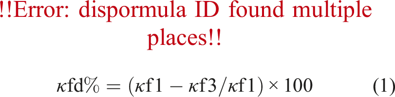
The magnetic properties were studied in an AGICO Kappabridge MFK1-Fa/CS4 susceptometer. The magnetic susceptibility (κ) was quantified under normal environmental conditions (22°C–24°C) and a field of 200 A/m. Values were quantified in SI units at two frequencies, 976 Hz (κf1) and 15,616 Hz (κf3), from a 2.0-g sediment fraction in 8 cm3 paleomagnetic cubes. The frequency-dependent magnetic susceptibility (κfd%) was calculated and used as a normalized qualitative indicator, which relates to pedogenetic processes in the soil as follows (Dearing et al., 1996).
To ensure the reliability of the data on magnetic susceptibility, statistical outlier detection by the Grubbs test was performed. G-statistic greater than the critical value were discarded (p = .05).
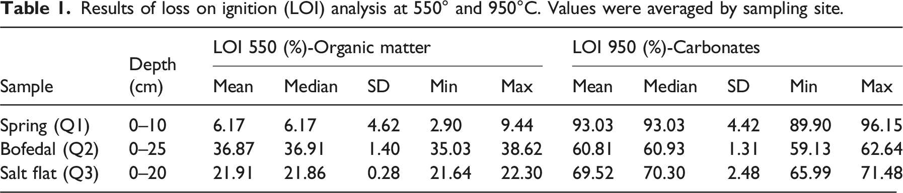
The organic matter and carbonate contents were estimated using the loss on ignition (LOI) method. This procedure involves drying 1 cm3 of each sediment sample in crucibles at 105°C for 2 h and weighing them. The dry samples were weighed before heating to 550°C in a flask over 1.5 h, left at 550°C for 2 h, then allowed to cool. The samples were weighed, then the crucibles were transferred to the flask and burned at 925°C. Finally, the crucibles were weighed again when they had cooled.
The sediment composition data were analyzed using an exploratory analysis with a multivariate approach. Principal component analysis (PCA) was employed to reduce the dimensionality of the dataset containing information on the elemental and mineralogical composition of sediments using the “vegan” package within the RStudio Software environment (version 4.3.1).
2.4. Water analysis: Physicochemical parameters and elemental composition
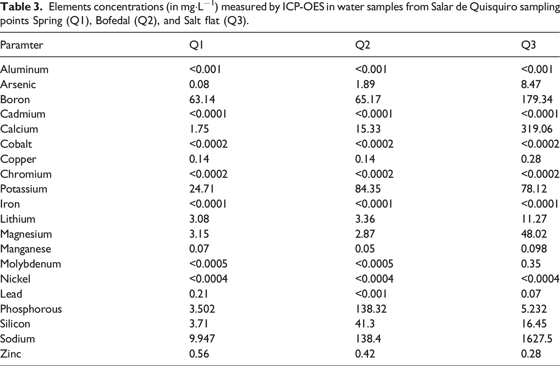
To analyze the concentration of chemical elements and detect the presence of elements impacting water quality, the water samples were analyzed using inductively coupled plasma optical emission spectroscopy (ICP-OES) in the chemical laboratory of the Centro de Investigación Tecnológica del Agua en el Desierto (CEITSAZA) at the Universidad Católica del Norte, Antofagasta, Chile.
The physical and chemical parameters of pH, conductivity, and temperature of surface waters were measured in situ with a multiparametric device (Hanna HI98194) during the field campaign in 2018. These data were complemented with further water monitoring carried out by the Environment Unit of the Atacameño Peoples’ Council (Consejo de Pueblos Atacameños, CPA) between 2021 and 2023.
2.5. Temporal changes in vegetational/water area
We used all available Landsat satellite images for the study area, corresponding to the Landsat 5, 7, 8, and 9 Collection 2, Tier 1. A total of 1717 scenes were used from 1986 to 2021. Therefore, this collection corresponds to the surface reflectance products and is radiometrically and atmospherically corrected (U.S. Geological Survey, 2021). Pre-processing included data harmonization between the different satellites, following Roy et al. (2016), data cleaning from clouds and aerosols using the quality assessment bands, and the temporal aggregation in the monthly records.
To assess the changes in water and vegetation area for the period between 1986 and 2021, we used the methodology proposed by Ashok et al. (2021), in which the difference between two spectral indices, the NDVI and Gao’s (1996) NDWI, is used to discriminate water and vegetation in mangrove ecosystems:
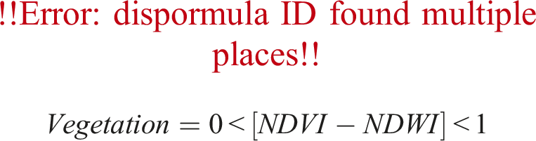
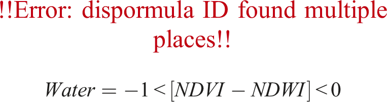
This approach does not consider the presence of bare or salty soil in arid environments. Hence, we propose a new approach to classify the land into three categories:
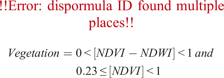
We used the NDVI threshold of 0.23 proposed by Chávez et al. (2019), which has been used to segment high Andean peatlands at a regional level in northern Chile.
3. Results
3.1. Characterization of sediment composition: mineralogical, elemental, and magnetic properties and LOI analysis
The mineralogical composition of the surface sediments (Figure 2(A)) showed an average crystalline fraction of silicates in the Q1 Spring samples, comprising 71.1% of the total weight of the samples, along with an average amorphous fraction of 28.9%. The silicates in layer A (0–5 cm) were identified, andesine (41.7%) and albite (17.1%) were the most predominant, while quartz, orthoclase, and muscovite were found in lower concentrations of 7.4%, 4.7%, and 1.1%, respectively. Concerning layer B (5–10 cm), there was a non-significant increase in the mineral phases quartz, orthoclase, and muscovite. Additionally, the amorphous fraction increased by 2.1% compared to layer A. The Bofedal samples (Q2) were mostly homogeneous without significant changes along the depth distribution. There was no crystalline fraction; however, Opal-A (amorphous silica) was detected with an average of 55.5% and an indeterminate amorphous fraction of 44.5%. (A) Mineralogical phases and (B) geochemistry of surface sediments in the Q1, Q2, and Q3 environments of the Quisquiro Salt Flat. For interpretation of the references to colours in this figure legend, refer to the online version of this article.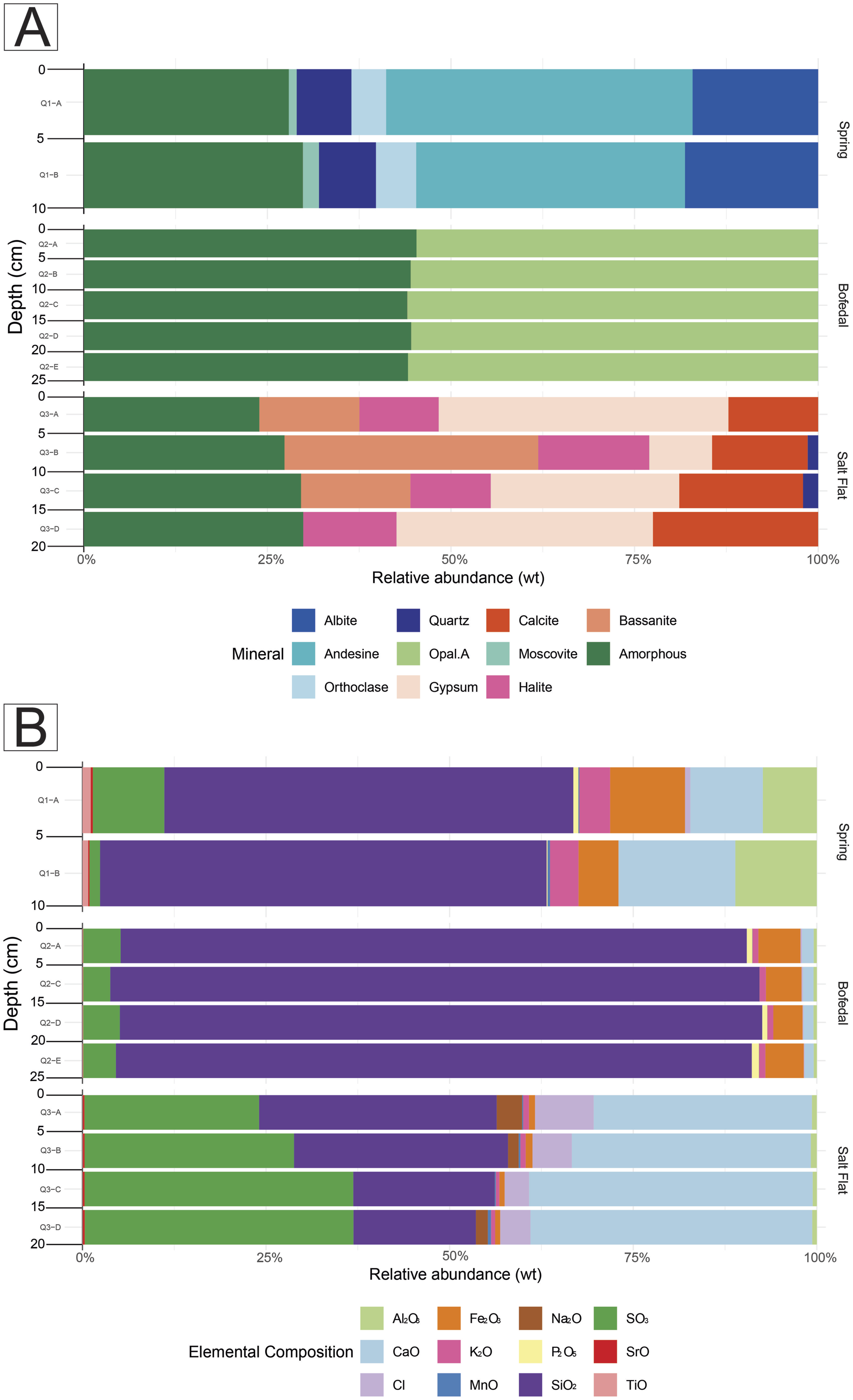
Finally, in the Salar samples (Q3), an average crystalline fraction of 72.3% and an average amorphous fraction of 27.7% were identified. In layer A, gypsum, basanite, calcite, and halite were identified in proportions of 39.5%, 13.6%, 12.2%, and 10.8%, respectively. In layer B, there was a significant increase in the abundance of the basanite, which reached 34.6% compared to layer A, while the gypsum phase decreased to 8.6%. Additionally, quartz was detected at 1.4% and 2.1% in layers B and C, respectively. Layers C and D showed a progressive increase in the abundance of gypsum directly related to depth, reaching 25.7% and 34.9%, respectively. Basanite decreased in layer C and was not detected in layer D. In the case of calcite, its abundance increased with depth. The halite mineral phase was found in all layers, with no significant changes, averaging 12.4%. Finally, described mineralogical composition of the Salar samples is accordingly observed by Troncoso et al. (2013) in other nearby salt flats, such as Salar de Tara, Salar del Laco, or Aguas Calientes I.
The elemental chemical compositions measured in the surface sediments from the three sampling points contained major and minor elements (Figure 2(B)). Among the major elements, silicon (Si) and oxygen (O) were detected at all sampling points. The results of the Tukey test for these elements showed significant paired differences (p < .005) between all the sampling points. The silicon (Si) concentrations in Q1 had an average value of 27.20% (total weight of the samples), while for Q2 and Q3, the values were 40.54% and 11.35%, respectively. In the case of Q3, other major elements appeared in great abundance, such as calcium (Ca) and sulfur (S), which increased with depth. In the case of Ca, there are significant differences between all the sampling points when paired comparisons were made, unlike S, which differed only in Q3. Iron (Fe) was at greater average concentrations in Q1 (5.47%) and Q2 (3.46%) and significantly lower concentrations in Q3 (0.56%) than the other sampling points. Minor elements, such as copper (Cu), arsenic (As), manganese (Mn), and phosphorus (P), were not significantly different between sampling points. Titanium (Ti) showed significant differences between Q1 and Q2 and Q1 and Q3 but not between Q2 and Q3. The average concentrations of potassium (K) and aluminum (Al) in Q1 were 3.34% and 4.88%, respectively, suggesting a relationship with tectosilicate content in this environment (see Supplemental Material).
Variations in bulk magnetic susceptibility (κ) and frequency-dependent magnetic susceptibility (κfd%) are shown in Figure 3. In Q1, the k values ranged from 1.182 × 10⁻⁴ to 2.086 × 10⁻⁴ (SI), with an average value of 1.634 × 10⁻⁴ (SI). The highest k values were measured in Q1, while the lowest k values were detected in Q2 and Q3, with average values of −2.15,796 × 10−6 (SI) and 2.043 × 10⁻⁵ (SI), respectively. Q2 is a unique environment where negative values were detected, suggesting the major presence of diamagnetic sediments, in contrast to Q1 and Q3, where paramagnetic materials were identified. The parameters κ and κfd% had opposite patterns along the sample. The κfd% parameter values ranged from 4.41% to 5.11% in the sediment layers of Q1. For the sediment layers of Q2, the κfd% parameter ranged from 6.3% to 10.10%, with an average value of 7.7%, discarding outliers of D layer. In this environment, in the case of the sediment layers of Q3, the κfd% values ranged from 2.84% to 4.91%, with an average value of 4.03%, similar to Q1. These differences suggest changes in the detrital inputs and authigenic production in the system. Magnetic parameters measured per sampling site and depth: Values of bulk magnetic susceptibility (κ, top row) and frequency-dependent magnetic susceptibility (κfd%, bottom row) as a function of depth of samples from sampling points Spring (Q1), Bofedal (Q2), and Salar (Q3).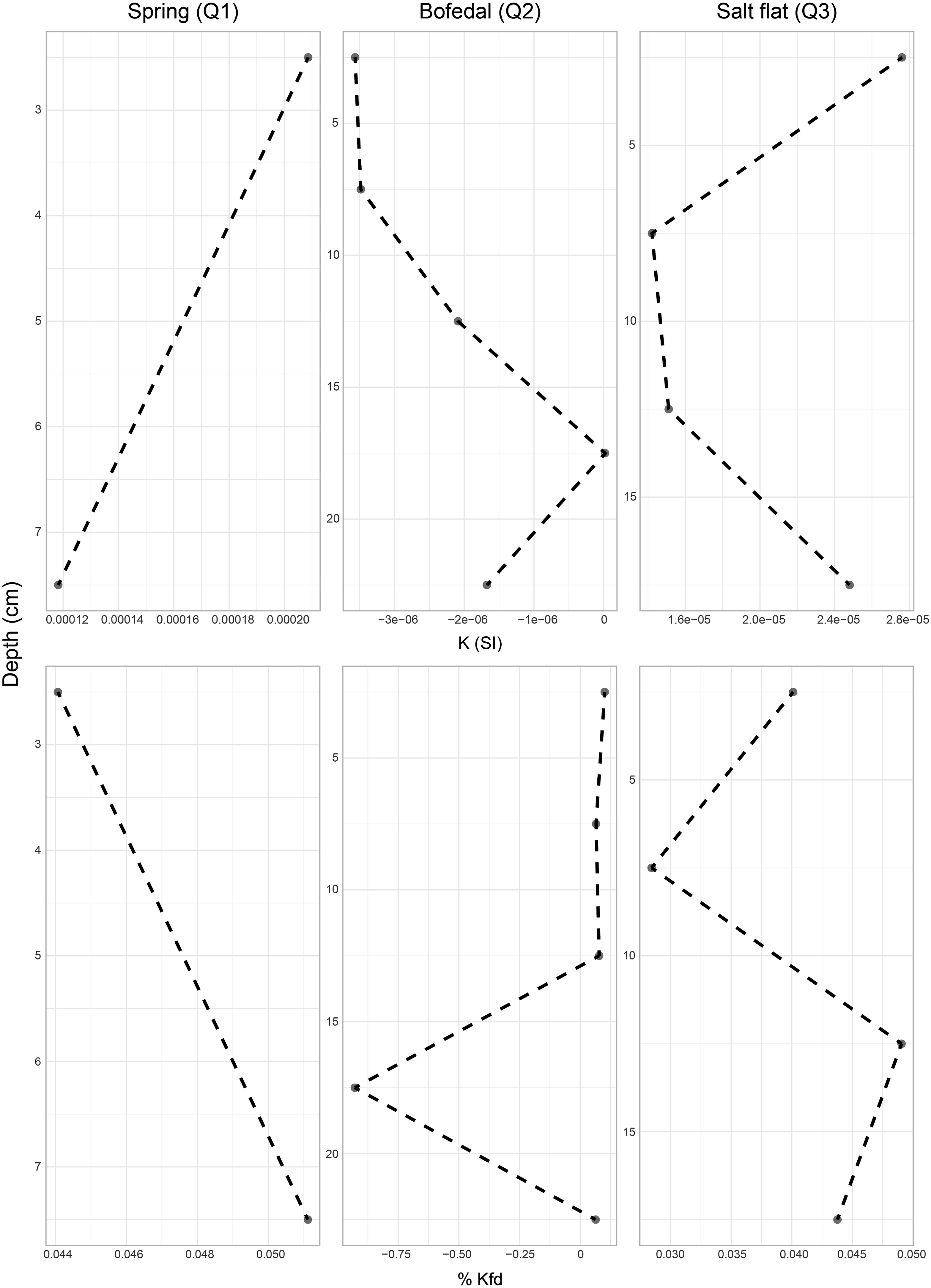
Results of loss on ignition (LOI) analysis at 550° and 950°C. Values were averaged by sampling site.
3.2. Physicochemical characteristics and variability in water composition
Physicochemical parameters of water samples from the Salar de Quisquiro. Points Q1, Q2, and Q3 were measured and compared with points QQ-01 and QQ-03 in the annual water monitoring report from Toconao (AIC De Pueblos Atacameños, 2023).
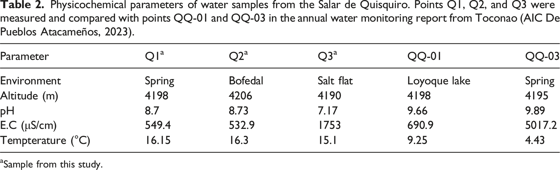
aSample from this study.
Elements concentrations (in mg·L−1) measured by ICP-OES in water samples from Salar de Quisquiro sampling points Spring (Q1), Bofedal (Q2), and Salt flat (Q3).
3.3. Temporal changes in vegetational/water area
Figure 4 shows a monthly time series of the areas covered by water and vegetation within the study area. There is a strong seasonality in both areas, particularly the vegetation area. Although it varies by year, the peak in the water area occurs between February and May, following the rainy season, as the peak of the vegetation area. However, the vegetation areas show a more consistent seasonal behavior, sharply increasing in November, tripling its area by February, and declining from May to reach its minimum in June. The hydrological years 2012–2013 and 2019–2020 had the largest water areas, coinciding with years of maximum precipitation, especially 2019–2020 (Figure 4). (A) Time series of area covered by water and area covered by vegetation in the study region. The area with vegetation has been multiplied by 10 to facilitate the visualization. (B) Time series of monthly precipitation at a meteorological station located 75 km from the study area (at Camar location). For interpretation of the references to colours in this figure legend, refer to the online version of this article.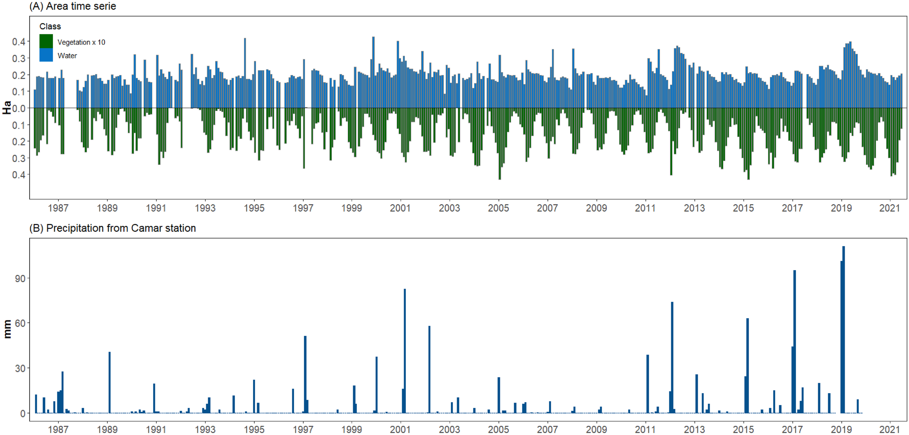
4. Discussion
The unique and complex nature of HAWs makes them vital for understanding the interplay between environmental factors and ecosystem dynamics. Our study of the Salar de Quisquiro demonstrates the intricate heterogeneity of these environments, as evidenced by the physical and chemical characteristics of surface sediments, water properties, and vegetation cover. Our analyses show that depositional conditions facilitate the formation or entry of sediments into these shallow water environments, making them highly dynamic. The present results suggest a close relationship between precipitation and water availability, and vegetation cover measured through NDVI and NDWI. Summer rainfall allows recharge, which is particularly important for the vegetation associated with these aquatic ecosystems (Figure 5). Frequency Distribution (FD) of the areas covered by (A) water and (B) vegetation calculated from records of 34 hydrological years (from 1986–1987 to 2020–2021). For interpretation of the references to colours in this figure legend, refer to the online version of this article.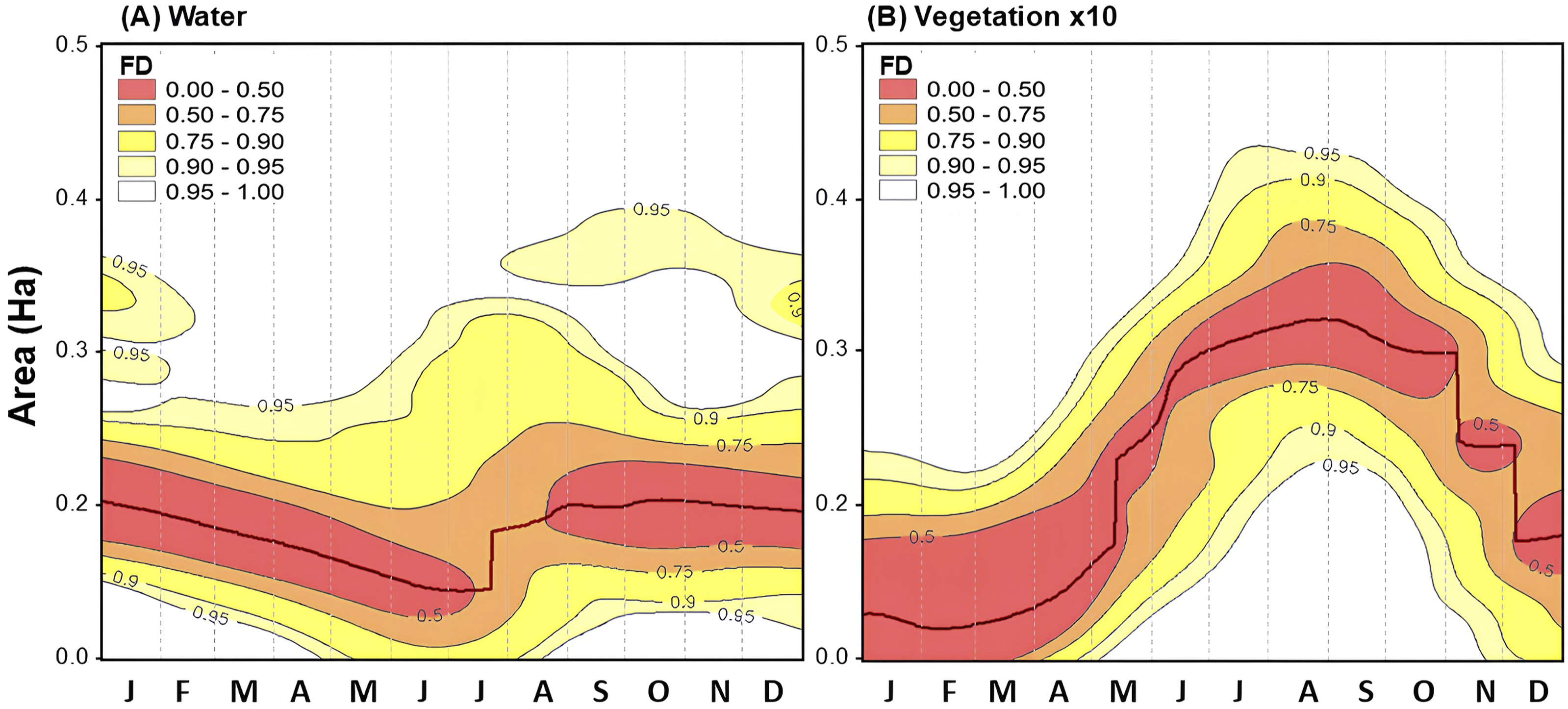
4.1. Spatial heterogeneity of Salar de Quisquiro
Significant differences in mineralogical, elemental, and magnetic properties were observed in inter- and intra-site sediments despite the spatial proximity of sampled sub-environments. The dominance of the crystalline fraction and the abundance of calcium sodium plagioclases in the spring reflected the input of volcanic mineral debris directly related to the basement of the Atana Ignimbrite, corresponding to silica-rich deposits of dacitic and rhyolitic composition. This volcanic proximity could also be responsible for high Pb concentrations in the spring water. This agrees with the mineralogical phases found, including feldspars and quartz, which contain Al and K correlated with the magnetic properties of the sample. Combined with the dominance of silicates, results suggest that detrital processes dominate in the spring sub-environment.
In the bofedal sub-environment, the combination of an alkaline pH, as recorded in this study, and significant percentages of amorphous material could promote silica precipitation in the form of opal-A. The alkalinity facilitates the solubility and subsequent precipitation of silica, while the amorphous content provides nucleation sites for opal-A formation (Jones and Renaut, 1997). High opal values have also been reported in poorly drained soils and sediments subject to seasonal or permanent waterlogging, highlighting the influence of hydrological conditions on silica precipitation (Clarke et al., 2003). Elements such as O, Si, and Fe were greatly concentrated in this sampling area, and large amounts of organic matter were detected in the LOI analysis, suggesting highly productive conditions. The positive frequency-dependent susceptibility suggests an authigenic origin, with the formation of in situ magnetic minerals during wetter climate conditions and Fe-rich aqueous solutions precipitating in the sediments. These authigenic processes could be associated with the effects of variations in the water table level and climate fluctuations on magnetic minerals in the sediments (García-Sanz et al., 2021; Pizarro et al., 2019). However, there is a large negative anomaly in layer D (−92.9%), which could be considered a measurement error, even though other negative k values were observed in some layers of the wetland, which combined with >5 kfd% values, may indicate an unpredicted response associated with specific conditions in that area, such as the amorphous fraction of opal-A and unidentified amorphous material.
Bofedales are highly productive, biologically diverse, and ecologically varied environments (Squeo et al., 2006; Villarroel et al., 2014). The formation of peat, a key process in the development of a bofedal, would be controlled by authigenic mechanisms that promote high concentrations of nutrients and organic matter. Bofedales contribute to regulating the hydrological cycle and controlling erosion because they act as water reservoirs during wet seasons that then gradually release water during drier periods (Garcia and Otto, 2015), leading to seasonal variation.
The intra-site variation in mineralogical and geochemical composition suggests that salt flat is the most variable analyzed sub-environment. Changes in the mineralogy reveal increasing sulfate precipitation toward the top samples, where the gypsum concentrations are greater, consistent with the increased evaporation and concentration of certain salts. However, the conditions for basanite formation significantly increase with layer depth, suggesting prior events of increased gypsum dehydration and diagenesis. Higher temperatures in the salt flat are required to transform the gypsum into basanite. These mineral phases agree with the composition of the calcium-rich brine, which favors the formation of calcium sulfate and carbonate minerals (Risacher and Fritz, 2009). The varying gypsum and basanite concentrations in different layers would indicate conditions associated with eruptive or climatic events. Changes in evaporation intensity and relative humidity at different times could promote the formation of basanite or gypsum (Schmidt et al., 2011). This mineralogical composition is shared by other nearby salt flats (Troncoso et al., 2013). Still, it differs from that observed in salt flats located further south, such as Salar de Gorbea, which presents a salt crust of more variable mineralogy, with more types of sulfates, the presence of borates, and occasional carbonate content (Pueyo et al., 2021). This suggests the relevance of basin-level processes in the observed structuring.
The precipitation of carbonates, sulfates, and chlorides suggests the progressive formation of brines of different concentrations (Hardie, 1984). In the case of calcite, an increase with depth could indicate continuous precipitation processes or a higher concentration of carbonates at depth. Through the magnetic susceptibility analysis of the sediments of the salt flat, the possibility of detrital input produced by flash flood events into the salt flat (κfd < 3% associated with quartz in layer B) is observed. The moderate κfd% values, combined with the Fe, S, and Ti concentrations, suggest the presence of small magnetic mineral particles of authigenic or detrital origin (Evans and Heller, 2003; Pizzaro et al., 2019). Increasing trends in the k and κfd% at greater depths suggest the presence of magnetic minerals, possibly Fe and Ti-rich minerals, such as magnetite or titanomagnetite. This agrees with the positive magnetic susceptibility, with the lowest values recorded in the subsurface sediments (layer B), where detrital processes mainly determine the mineralogy.
In summary, these results provide a coherent view of the spatial heterogeneity in the three sub-environments of the Salar de Quisquiro. In the spring sub-environment (Q1), the contribution of detrital material of volcanic origin, evidenced by the presence of silicate minerals and a high magnetic susceptibility, correlates with the high concentration of silicon (Si) and aluminum (Al), indicating a silicate-based sedimentary environment. In the bofedal sub-environment (Q2), the high magnetic susceptibility values highlight the presence of magnetic minerals of authigenic origin, suggesting the influence of hydrological changes. The predominance of amorphous silica (opal-A) and the high content of organic matter, according to the LOI values, reflect a productive environment shaped by waterlogged conditions. Finally, in the salt flat sub-environment (Q3), the predominance of evaporitic minerals, such gypsum, and basanite, in addition to a moderate magnetic susceptibility suggest a mixture of detrital and authigenic inputs, influenced by evaporation that favors the precipitation of sulfates and carbonates, which is supported by high levels of calcium (Ca) and sulfur (S). Taken together, these findings underline the complex interaction between detrital inputs, organic productivity, and evaporite processes, which configure the sedimentary dynamics of the Salar de Quisquiro.
Spatial variations in the sediments across the Salar are closely tied to distinct processes occurring in each sub-environment, some of which are promoted by episodic or regular climatic events. These processes, linked to past and present climatic conditions, are essential for understanding how external forces shape the environment over time, not only sedimentary or depositional environment but consequently, how the herders have dynamically used the different sub-environments to satisfy their need for water and fodder, mainly.
4.2. Temporal variability of precipitation in Salar de Quisquiro
Alberto Tejerina, a Lickan Antay herder from the Toconao community, living in his estancia—seasonal settlements for herding—of the Salar de Quisquiro, where he is currently the only person raising llamas, states that while he “has no memory of dry years, where there has been no rain at all, the intensity and amount of rainfall has decreased from the 1990s onwards 2 . The last big rainfall was in Loyoque in 2019.”
Alberto also recalls that the level of Loyoque Lake has never risen substantially because the water always drains toward the salt flat, maintaining the relatively constant levels of the meadows (locally know as vegas) and bofedales. However, he also says the flows have decreased in the area over the last 50 years, which he associates with a decrease in rainfall. In contrast, the NDVI and NDWI analyses suggest that an increase in water cover is directly related to an increase in vegetation cover in Salar de Quisquiro. This could be associated with other precipitation events, such as snow. Alberto recalls that “in the past, the mountain peaks were snow-capped for most of the year.” Snow events are concentrated in winter, and although there is snow-water in summer, it melts quickly, which could explain the recent increase in water availability. He also says, “In the old days, the tropas 3 passes were conditioned by the duration of the snowfall, which could last about 3 months, between June and September. The last big one was in about ’85”. That year, he was forced to remain in Argentina until September, when he could return to Chile. The last large snowfall he remembers was in 2003.
The observations of local community members, such as Alberto, provide valuable insights into long-term climatic patterns and their impacts on HAWs. His memories of changing precipitation patterns align with the quantitative scientific data, highlighting the complex interplay between rainfall, snowmelt, and ecosystem dynamics in the Salar de Quisquiro. The apparent increase in water cover and vegetation suggests that other hydrological inputs, such as snowmelt, might be crucial in maintaining these wetlands. This underscores the importance of considering local knowledge in conjunction with scientific data to comprehensively understand environmental changes in these ecosystems. The Community of Toconao and Instituto de Investigaciones Arqueológicas y Museo (IIAM) have performed systematic surveys based on a management plan for the high Andean salt flats of Toconao, and a large part of Quisquiro is included in the monitoring and conservation strategies of the sites of the territorial community that cares for this territory.
Field samples obtained in 2018 showed conductivity values around 549.4 (µS/cm) in the spring, similar to those obtained by the CPA during monitoring in 2021–2023 in the same area. However, in the salt flat, the electrical conductivity in 2018 was orders of magnitude larger than that obtained in 2021–2023. This great variation could be explained because, as stated before, the salt flat sub-environment is the most dynamic, variable, and dependent on external conditions of the three sampled sub-environments. The last important rainfall events occurred during the 2019–2020 hydrological year; thus, those events are expected to input freshwater into the systems, diluting the saltiest water that had concentrated during the previous dry years.
4.3. Human occupation of Salar de Quisquiro
This region is located in the Altiplano–Puna volcanic complex, formed mostly by siliceous ignimbrite deposits (Grosse et al., 2017; Kay et al., 2010). Continual Cenozoic volcanism, regional faults, the formation of a closed drainage system, and the chemical weathering of surrounding mountain chains have facilitated the formation of evaporites (Alonso et al., 1991; Vandervoot et al., 1995), which have defined landscapes that have been recognized and used by biological communities, including human populations.
The close association between wetter periods and human occupation is a long-standing and decisive factor in the development of the early human communities of the desert and highlands of the region. According to the present evidence, human exploitation of the high Andean lakes did not begin at the time of greatest humidity at the end of the Late Pleistocene and Early Holocene, based on lake levels and pollen records (Grosjean et al., 2001), but rather at the end of the Early Holocene, when aridity began to increase on a regional scale (Grosjean et al., 2003; Sáez et al., 2016). As a consequence of that increasing aridity, lake levels decreased. At the end of the Pleistocene, some sectors were transformed into wetlands that attracted fauna and, with it, human populations, for example, Laguna Miscanti in the Middle Holocene (Núñez et al., 2018).
In Salar de Quisquiro, 11 archaeological sites have been identified, which are distributed along the margins of the current basin in three main areas: the western, northwestern, and southern margins. The western margin corresponds to dispersions mainly composed of lithic material in the open air on the margins of the Salar of 450, 2500, and 3 m2. The presence of Tuina-type triangular points has led to the characterization of these occupations as campsite workshops of hunter–gatherer societies from the end of the Early Archaic Period, that is, around 10,000–9500 cal BP. These communities were formed by mobile groups of low demographic density, which developed seasonal altitudinal mobility between the lowlands on the edge of the Atacama salt flat (2000 m a.s.l.), the intermediate ravines (2700 to 3200 m a.s.l.), and the high Andean lakes (>3800 m a.s.l.) (Núñez et al., 2002). Within this model, the Quisquiro occupations (1 to 3) would be part of summer sites dedicated mainly to vicuña hunting.
The sites in the southern margin, currently containing the most extensive playa lake area, appear to be of lesser magnitude. They consist of scatterings of lithic material, such as scrapes, that suggest they were used temporarily during hunts, as places where the prey, once killed, was butchered and then transported to the camp. Although the materials are less diagnostic, their characteristics and proximity indicate that they were related to the archaic occupations of the western margin.
In the northwestern margin, close to the sampling points recorded in this study, there is a diversity of sites (Quisquiro 4 to 9), among which contemporary archaic occupations probably coexisted (Quisquiro 9). They also include settlements from late periods (agro-pastoralist communities), shown by the presence of stone structures (pircas) and ceramic fragments from containers for eating and containing liquids, mainly from the Late Intermediate Period (circa 1000–1400 AD). This area seems to have hosted a long-term chronological sequence of occupation, probably due to more stable water resources than the western margin. Complementarily, the types of sites show a greater diversity in their functions. These functions include hunting stops (Quisquiro 8), camps (Quisquiro 7), workshops (Quisquiro 6 and 9), hunting events (Quisquiro 5), transit shelters associated with inter-Andean roads (Quisquiro 4) (Núñez et al., 2005).
In summary, there is an evident differential distribution of archaeological evidence in time and space in this region, which seems to be related to the paleoenvironmental and climatic dynamics in the Salar de Quisquiro in the past. In the past and present, proximity to freshwater springs was a determining factor in the temporary or permanent distribution of human settlements.
Godfrey and Álvarez‐Amado (2020) have stated that any brines or evaporite sequences formed in any of the Caldera La Pacana lakes during their active stages would be Li-rich, although not the exceptionally high Li concentration observed in the Salar de Atacama, the central focus of lithium mining. Compared to other salt flats where the chemical composition has been measured in similar analytical methodologies, the Li in Quisquiro waters (3.08–11.27 mg·L−1) is similar to that of other high Andean salt flats, such as Salar de Aguas Calientes (8.5–17.5 mg·L−1) and greater than Salar de Carcote springs (<1 mg·L−1) (Hermosilla et al., 2019). Quisquiro waters showed high boron concentrations, the extraction of which supported the mining exploitation during the 1970s and 80s in Quisquiro by a foreign company that abandoned the extraction. The remains of the processing plant are near Alberto Tejerina’s estancia. The exploitation of boron from other salars in the Andean Altiplano, such as Salar de Ascotán, since the 1980s, has had dramatic environmental consequences on hydrology, landscape configuration, and biodiversity (Heine-Fuster et al., 2021; Lobos et al., 2018; Vila et al., 2020). Therefore, the conservation of Salar de Quisquiro and the human and non-human communities inhabiting it is potentially threatened due to past, current, and future extractive interests.
With the current possibility of increasing non-metallic mining prospecting in the region, it is necessary to highlight the territorial rights, autonomy, and claims of Indigenous communities, who, both in the past and at present, have preserved HAWs through their ancient identification with the territory and their use and comprehensive management practices. Whether permanent or sporadic, these practices are associated with seasonal and long-term climatic variability. The knowledge of these inhabitants, as shown by Alberto Tejerina’s observations, provides valuable insights into the long-term climatic patterns and their impacts on these wetlands. Integrating local knowledge with scientific data is crucial for future research, offering a more comprehensive approach to understanding environmental changes. Emphasizing this integrative approach will help develop effective and culturally sensitive conservation strategies amidst ongoing environmental and climatic challenges, particularly in the face of the growing threat from mining activities.
5. Conclusions
Through transdisciplinary work that integrated physical and chemical analysis of sediments, remote image analysis, and dialogues and reports with the Likan Antay Community of Toconao, the spatial and temporal heterogeneity of a salt flat, the Salar de Quisquiro in the Andean Altiplano was evaluated in light of global interest in lithium mining.
Results showed that (1) the depositional conditions facilitate the formation or entry of sediments into these shallow water environments, making them highly dynamic; (2) differences in mineralogical, compositional, and magnetic properties were observed in inter- and intra-sampling points and the salt flat was the most variable analyzed sub-environment; (3) there is a close relationship between precipitation and water availability and vegetation cover; and (4) the proximity to freshwater springs in the Salar de Quisquiro is a determining factor in temporary or permanent distributions of human settlements.
This study contributes to the ongoing global dialogue on resource extraction and the rights of indigenous and land-connected peoples, particularly in regions where energy transition minerals intersect with indigenous territories (Owen et al., 2023). The ecological and cultural significance of the Salar de Quisquiro mirrors challenges in other regions, as the increasing global demand for critical minerals like lithium and graphite leads to more significant encroachment on territories historically less affected by industrial development. In that sense, any research related to the geopolitics of salt flats entails a global discussion based on the connection between the lithium economy and the energy transition. The increase of non-metallic mining in HAW’s and current national lithium policies highlights the interconnectedness of local ecosystems and global extractive economies, thus reinforcing the international dimension of the study. This expansion results in conflicting objectives: economic growth through extraction versus preserving cultural and environmental values. The rush to extract minerals often sidelines meaningful consultation with indigenous and peasant communities, exacerbating social inequalities (Owen et al., 2022).
In this research, we emphasize the transformative power of scientific inquiry in supporting territorial sovereignty. By deepening their understanding of their land, Indigenous communities are empowered to assert their rights and manage their environments according to their cultural practices. Science becomes not just a tool for studying ecosystems but a form of power that reinforces indigenous claims to territory while resisting external pressures, such as mining. Importantly, this study is co-authored by members of the Likan Antay community, reflecting their collective knowledge, experiences, and stewardship practices. Their involvement moves beyond participation to knowledge production, ensuring Indigenous perspectives are fully integrated into scientific inquiry. This collaboration is articulated between the different HASS/STEM university laboratories and the Environment and Territory Unit of the Lickan Antay Community of Toconao and reinforces the community’s role in shaping research that directly impacts their land and livelihoods.
Our research highlights the importance of recognizing indigenous territorial management as central to ecological conservation. While the global energy transition is crucial in addressing climate change, it risks repeating patterns of land appropriation and environmental degradation unless we challenge the entrenched colonial dynamics that still shape scientific research and resource extraction (Liboiron, 2021). Bridging the historical divide between Indigenous knowledge and scientific methods is essential to foster a more just approach to ecological conservation and ensure that Indigenous communities maintain agency over their lands and ecosystems amid growing external pressures.
The findings from this study point to the need for research frameworks that do more than simply integrate indigenous knowledge with scientific methods. These frameworks must actively decolonize research processes by addressing the power imbalances and historical injustices in resource extraction. Future studies should dismantle the colonial legacies embedded in scientific practice, centering indigenous sovereignty and ensuring that local communities retain full control over their lands. This shift requires rethinking how research is conducted in Indigenous territories, ensuring that scientific inquiry supports and respects Indigenous knowledge and governance systems rather than undermining them.
Supplemental Material
Supplemental Material - Spatial and temporal heterogeneity of depositional environment and vegetational cover in a salt flat of the Lickan Antay Territory of Toconao, Northern Chile
Supplemental Material for Spatial and temporal heterogeneity of depositional environment and vegetational cover in a salt flat of the Lickan Antay Territory of Toconao, Northern Chile by Adriana Aránguiz-Acuña, Gissel Alday-Galleguillos, Daniel Pérez, Roberto O. Chávez, Matías Olea, Comunidad Lickan Antay de Toconao, Manuel Prieto, Valentina Figueroa, Christian Espíndola, Alberto Tejerina, Félix Galleguillos, Camilo Sanzana, Lautaro Núñez, and Rodrigo Loyola in Progress in Physical Geography: Earth and Environment
Footnotes
Acknowledgments
A.A-A. thank to Laboratorio de Ecología Acuática fieldwork-team, specially to Inger Heine-Fuster and Pablo Pérez-Portilla, to the Unidad de Territorio y Medio Ambiente, Comunidad Lickan Antay de Toconao and to the PriPoDa lab IIAM-UCN.
Declaration of Conflicting Interests
The author(s) declared no potential conflicts of interest with respect to the research, authorship, and/or publication of this article.
Funding
The author(s) disclosed receipt of the following financial support for the research, authorship, and/or publication of this article: This work was supported by the ANID-FONDECYT [grant number 1200423], UTA-Mayor [grant number 9735-23] and ANID-Milenio [grant number NCS2022_009].
Supplemental Material
Supplemental material for this article is available online.
Notes
References
Supplementary Material
Please find the following supplemental material available below.
For Open Access articles published under a Creative Commons License, all supplemental material carries the same license as the article it is associated with.
For non-Open Access articles published, all supplemental material carries a non-exclusive license, and permission requests for re-use of supplemental material or any part of supplemental material shall be sent directly to the copyright owner as specified in the copyright notice associated with the article.