
Abstract
The Düziçi–İskenderun Fault Zone (DIFZ), located within the Amanos Mountains at the intersection of the African, Arabian, and Anatolian plates, is a structurally segmented and tectonically active component of the Eastern Anatolian Fault System (EAFS). This study integrates morphotectonic analysis, paleoseismological reevaluation, and limited field observations to elucidate the DIFZ’s role in deformation patterns and seismic potential. Morphotectonic analysis reveals spatial variability in uplift and erosion, with heightened tectonic activity in basins 4, 9–11, and 18, linked to structural complexities such as fault step-overs, bends, and abrupt topographic changes, suggesting localized strain concentration and elevated seismic potential. Field observations corroborate these findings, documenting triangular facets, V-shaped valleys, elongated basins, and fault scarps indicative of active crustal deformation. Paleoseismological raw data, taken from previously conducted studies at the Elbeyli (Düziçi) and Cona (Osmaniye) sites, identify three surface-rupturing events in the past ∼12 ka, with Bayesian-derived recurrence intervals of 4.3–4.7 kyr and interevent times of 0.3–9.1 kyr. Magnitude estimates (Mw ≤ 6.7) and slip rates (<1 mm/yr) classify the DIFZ as a moderately active fault zone. However, limited paleoseismic data from the Erzin and Payas segments constrain comprehensive hazard assessments. These findings highlight the DIFZ as a tectonic linkage between the EAFS, Dead Sea Fault, and Cyprus Arc, facilitating strain transfer across the southeastern Anatolian orogenic front. The integration of morphometric and paleoseismological approaches offers a refined framework for assessing seismic hazards in this tectonically complex region.
Keywords
Introduction
The East Anatolian Fault System (EAFS) stands as one of the world’s most prominent intracontinental transform fault zones, accommodating the westward motion of the Anatolian Plate relative to the Arabian Plate (Şengör, 1980; Şengör et al., 1985; Şengör and Yılmaz, 1981). The dynamic and complex nature of this fault system has been underscored by recent seismic events. Among these, the Mw 6.8 Sivrice (Elazığ) earthquake of 2020 marked a significant reactivation of the EAFS, with Coulomb stress modeling revealing stress redistribution to adjacent fault segments (Tatar et al., 2020).
Three years later, on February 6, 2023, the region experienced two catastrophic earthquakes in rapid succession: the first (Mw 7.7) on the Pazarcık segment, followed closely by a second (Mw 7.6) on the Çardak segment (Figure 1). This dual-sequence event produced extensive surface ruptures and multi-segment faulting, highlighting the system’s complexity (Aksoy et al., 2023; Jia et al., 2023; Karabacak et al., 2023; Softa et al., 2024; Över et al., 2023). The Mw 7.7 Pazarcık earthquake initiated on the Narlı Fault, a subsidiary structure within the EAFS, and activated the previously locked Pazarcık segment, resulting in surface ruptures across the Amanos, Pazarcık, and Erkenek segments (Aksoy et al., 2023; Jia et al., 2023; Karabacak et al., 2023; Över et al., 2023). Segmentation and fault geometry of the East Anatolian Fault System (EAFS) within the tectonic structure of eastern Türkiye, adapted from Duman and Emre (2013). The map illustrates both historical earthquake data (Ambraseys 1989; Ambraseys and Finkel 1995; Ambraseys and Jackson 1998; Tan et al., 2008) and instrumental records (AFAD 2024) along the EAFS.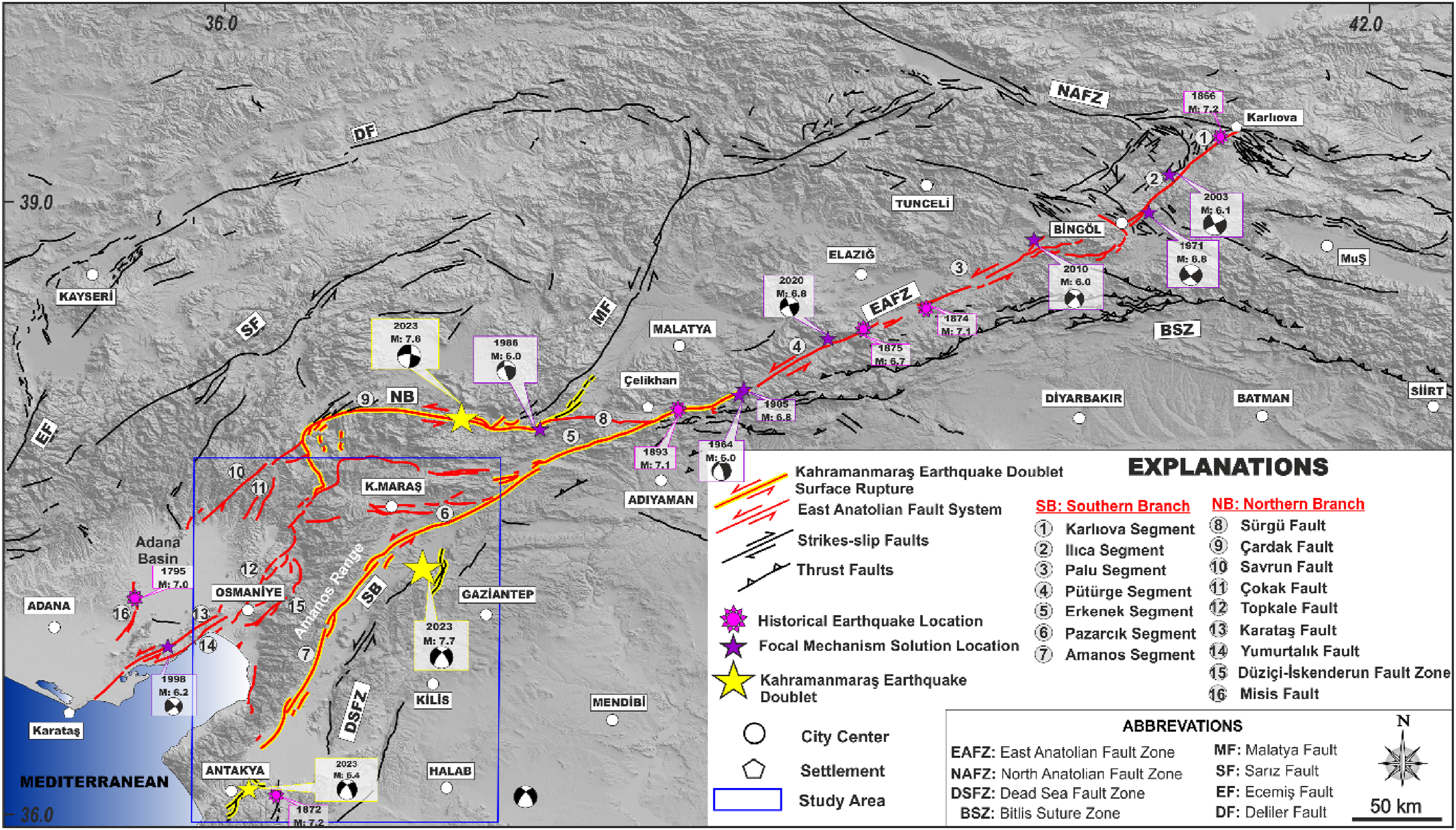
Stress redistribution following these events likely contributed to the Mw 6.4 Defne earthquake, which occurred 14 days later near the southern Amanos segment. These sequences underscore the importance of secondary and subsidiary fault structures, particularly in regions with lower slip rates and longer seismic recurrence intervals, such as the Kahramanmaraş area (Figure 1).
The northern strand of the EAFS, often referred to as the Sürgü-Misis Fault System, diverges from the main fault trace near Çelikhan and extends southwestward to the Misis Fault near İskenderun Bay. This strand’s eastern part, stretching from Çelikhan to the Göksun bend, includes the Sürgü and Çardak segments. During the Mw 7.6 Ekinözü/Elbistan earthquake, the Çardak segment ruptured, producing surface faulting, but the rupture did not propagate into the adjacent Sürgü segment. Instead, it deviated toward the Doğanşehir segment, reflecting the complex rupture dynamics and stress transfer pathways in the region (Softa et al., 2024).
In contrast, the southwestern part of the northern strand exhibits a ∼45° reorientation from the Göksun bend, aligning northeast-southwest and encompassing the Savrun, Çokak, Misis, Toprakkale, Yumurtalık, Karataş, and Düziçi-İskenderun fault segments (Duman and Emre, 2013). This region is characterized by distributed deformation and interaction with major tectonic features, including the Dead Sea Fault Zone (DSFZ) and the Cyprus Arc, resulting in elevated seismic hazards and structural complexity (Figure 1).
Despite its tectonic significance, the Düziçi–İskenderun Fault Zone (DIFZ) remains comparatively underexplored, with limited quantitative morphotectonic and paleoseismological constraints on its recent deformation history. Understanding its activity is critical because the DIFZ forms a key structural linkage that facilitates strain transfer between the EAFS, DSFZ, and the Cyprus Arc, three of the most active tectonic systems in the Eastern Mediterranean. This study aims to elucidate the tectonic deformation and activity along the Amanos Mountains using an integrated approach that combines tectono-geomorphic analyses and paleoseismological re-evaluation.
Tectono-geomorphic indices derived from drainage basin and channel network analyses provide quantitative proxies for assessing active tectonics, particularly in regions like the DIFZ, where surface expressions of deformation are subtle or absent despite ongoing stress accumulation. Synthesizing these results with existing paleoseismological data, this study offers a high-resolution perspective on neotectonic processes.
The outcomes are expected to enhance seismic hazard assessments for the İskenderun region and its surroundings, where interactions between the EAFS, DSFZ, and Cyprus Arc create a tectonically active and seismically vulnerable landscape. This multidisciplinary investigation seeks to advance our understanding of tectonic activity based on geomorphological aspects of one of southeastern Türkiye’s most critical seismogenic zones.
Geological and seismotectonic settings
The tectonic framework of the Eastern Mediterranean is primarily influenced by the convergence of the Arabian and Anatolian plates, a process that originated with the closure of the Neo-Tethys Ocean and the subsequent formation of associated suture zones (Şengör, 1980; Şengör et al., 1985; Şengör and Yılmaz, 1981). Within this framework, the East Anatolian Fault System (EAFS) emerges as a key structural feature (Figure 1). This northeast-southwest-trending, intracontinental, left-lateral strike-slip fault system extends between two significant tectonic triple junctions: Karlıova (Bingöl) in the northeast and Türkoğlu (Kahramanmaraş) in the southwest (Arpat and Şaroğlu, 1972, 1975; Şengör et al., 1985).
The segmentation of the EAFS has been the focus of extensive studies, with various models proposed based on geometrical discontinuities, fault bends, and rupture behaviors (e.g., Arpat and Şaroğlu, 1972, 1975; Barka and Kadinsky-Cade, 1988; Duman and Emre, 2013; Herece, 2008; Şaroğlu et al., 1992). From Karlıova to Çelikhan (Adıyaman), the fault system forms a relatively narrow deformation zone, while southwest of Çelikhan, it broadens significantly—reaching up to 65 km in width—encompassing the northern strand known as the Sürgü-Misis Fault System (Duman and Emre, 2013).
Geodetic studies using GPS data have provided short-term slip rate estimates for the EAFS, ranging from approximately 10.9 ± 2 mm/year along its main trace between Karlıova and Türkoğlu (McClusky et al., 2000; Reilinger et al., 2006; Aktug et al., 2016) to around 4.5 mm/year for the fault’s southwestern structural elements (Aktug et al., 2016). Paleoseismological investigations further corroborate these findings. Long-term slip rates derived from the Pazarcık and Erkenek segments align with the lower values recorded in the southwestern portion of the fault system (Karabacak et al., 2011; Yönlü and Karabacak, 2024).
Herece (2008) suggested that strain partitioning in the southwestern sector occurs across multiple structures, including the Erkenek and Gölbaşı segments, the Düziçi Fault, and smaller unmapped faults, as well as localized ductile deformation or folding. These factors collectively account for a cumulative slip rate of approximately 7.9 ± 0.3 mm/year. Support for these rates is provided by geomorphic markers such as offset drainage systems (Duman and Emre, 2013), displaced lithological boundaries (Rojay et al., 2001; Westaway, 2003), and radiometric dating of Quaternary basalts (Arger et al., 1996; Seyrek et al., 2008). Additional paleoseismological and geodetic studies reinforce the interpretation of distributed strain accumulation in the region (Duman et al., 2020; Çetin et al., 2003).
A significant contribution to our understanding of this zone comes from Duman et al. (2020), who conducted detailed paleoseismic trenching along the Sürgü-Misis Fault System. Their analysis of seven trench sites across four fault segments revealed Holocene strike-slip events accompanied by secondary normal and reverse faulting components. These findings demonstrate the capability of the Düziçi–İskenderun Fault Zone (DIFZ) and nearby segments, such as Düziçi and Osmaniye, to produce surface-rupturing earthquakes, despite a lack of historical evidence for such ruptures. This absence suggests prolonged strain accumulation over time.
Geographically, the Amanos Mountains are positioned between the northern and southern branches of the EAFS. They are bounded to the east by the northeast-southwest-trending Amanos segment and to the west by the north-south-trending, west-dipping Düziçi–İskenderun Fault Zone. The tectonic complexity of this region is amplified by its interactions with the Dead Sea Fault Zone (DSFZ) and the Cyprus Arc. The DIFZ, located at the southwesternmost tip of the EAFS’s northern strand, borders the western flank of the Amanos Mountains. This zone was activated during the Mw 7.7 Pazarcık earthquake of 2023, which ruptured the Amanos segment (Karabacak et al., 2023; Softa et al., 2024).
Methodology of morphometric indices
Detailed description of morphometric parameters utilized in the present study.

Hypsometric analyses, including the hypsometric curve and hypsometric integral, assess the degree of erosion within drainage basins and the extent to which tectonic processes have shaped them. First developed by Strahler (1952), the hypsometric curve visualizes the elevation distribution within the basin, while the hypsometric integral quantifies how far a basin is from a state of erosion and equilibrium. The Normalized Steepness Index (Ksn) investigates the relationship between slope and drainage area within a river profile, providing insights into the behavior of fluvial systems under tectonic influence. Hack (1957) laid the groundwork for Ksn analysis, while Whipple and Tucker (1999) further developed its theoretical framework. Ksn analyses are crucial for understanding river dynamics and uplift rates, especially in tectonically active regions. Gilbert metrics analyze landscape features to assess divide stability and the drainage basin dynamics. Building on Gilbert’s (1987) work, Willett et al. (2006) and Forte and Whipple (2018) introduced a suite of alternative metrics to assess drainage divide stability, such as cross divide variations in channel bed elevation, mean headwater hillslope gradient, and local relief. The χ method is used to analyze elevation differences, where divided are expected to move from lower to higher elevations, indicating tectonic uplift (Willett et al., 2006; Forte and Whipple, 2018). Hillslope gradients and local relief metrics are linked to erosion rates, with divides shifting from regions of high to low relief, reflecting erosional processes (Willett et al., 2006; Forte and Whipple, 2018). These metrics provide insights into the interaction between tectonic uplift, erosion, and landscape evolution (Table 1).
In this study, the quantification of all parameters was performed using high-resolution Advanced Land Observing Satellite (ALOS) Phased Array L-band Synthetic Aperture Radar (PALSAR) Digital Elevation Model (DEM), with a spatial resolution of 12.5-m, obtained from the Alaska Satellite Facility (https://asf.alaska.edu). This dataset accurately represents regional topography, essential for precise morphometric analysis and understanding drainage basin dynamics in this tectonically active region. Data processing and spatial analyses were conducted using advanced GIS and computational platforms, including ArcGIS (v10.8.2), Global Mapper (v26.0), QGIS (v3.40.1), and the MATLAB-based TopoToolbox and DivideTools (Forte and Whipple, 2018; Schwanghart and Scherler, 2014). These platforms facilitated the extraction, quantification, and thorough assessment of tectono-geomorphic parameters, providing a detailed understanding of tectonic and geomorphological processes.
Results
Morphometric analysis
Mountain front sinuosity (Smf)
Morphometric indices and their classes of the studied catchments and mountain fronts.
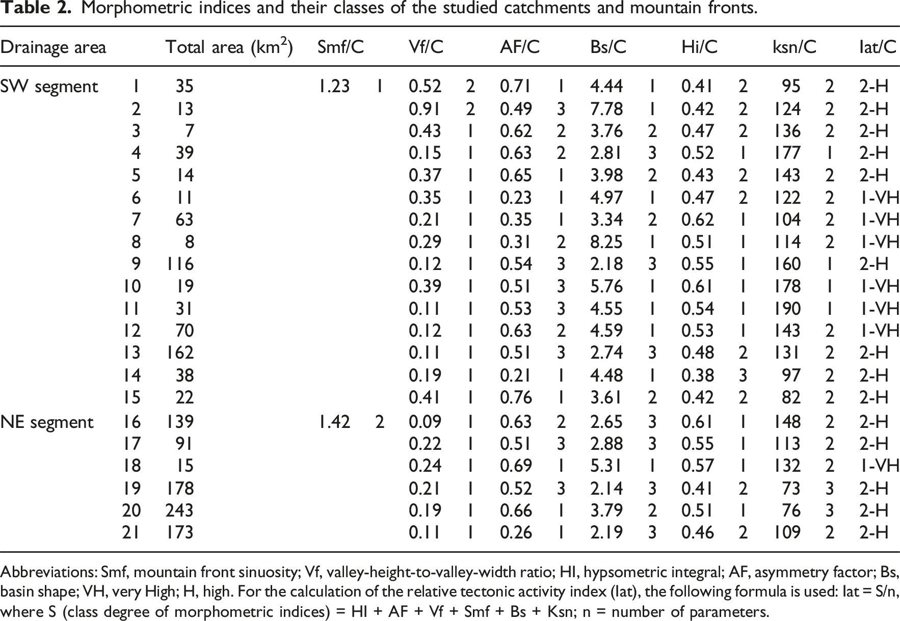
Abbreviations: Smf, mountain front sinuosity; Vf, valley-height-to-valley-width ratio; HI, hypsometric integral; AF, asymmetry factor; Bs, basin shape; VH, very High; H, high. For the calculation of the relative tectonic activity index (Iat), the following formula is used: Iat = S/n, where S (class degree of morphometric indices) = HI + AF + Vf + Smf + Bs + Ksn; n = number of parameters.

Morphometric indices map applied along the main river courses of the drainage basins on the western flank of the Amanos Range, superimposed on a digital elevation model and a simplified geological map (adapted from Akbaş et al., 2011). Geological units are represented as follows: Or: Ordovician clastics; Kt: Cretaceous neritic limestone; Mz: Mesozoic undifferentiated basic and ultrabasic rocks; Eo: Eocene neritic limestone; Mi: Miocene clastics, limestone, and basalt; Q: Quaternary alluvium. The pink areas denote the distribution of triangular facets. EAFS-DIFZ: East Anatolian Fault System-Düziçi-İskenderun Fault Zone; EAFS-AS: East Anatolian Fault System-Amanos Segment; EAFS-TS: East Anatolian Fault System-Toprakkale Segment; DSFZ-YS: Dead Sea Fault Zone-Yasemek Segment.
Valley floor width-to-height ratio (Vf)
The Vf values along the DIFZ provide further insights into the tectonic activity of the region. In the southern section (drainage areas 1–15), Vf values range between 0.15 and 0.91, while in the northern section (drainage areas 16–21), values fall between 0.09 and 0.22. These results illustrate distinct tectonic influences between the two regions. The southern section exhibits a wide range of Vf values, with some areas (e.g., drainage areas 5 and 6) showing relatively higher values (e.g., 0.52 and 0.91) suggesting moderate tectonic activity and wider valley floors. These regions are likely experiencing less tectonic forcing, with erosion becoming more dominant over time. In contrast, the northern section is characterized by narrower valley floors and significantly lower Vf values, with drainage areas 16 and 21 exhibiting values (e.g., 0.09 and 0.22), indicative on ongoing active faulting and higher tectonic influence (Table 2, Figure 2). The narrow and linear valleys in this region suggest that tectonic uplift and faulting are still strong, with accelerated erosion in response to ongoing tectonic processes. According to the Iat classification, the southern drainage areas are categorized into very high tectonic activity (for areas 1 and 2) and high tectonic activity (for most others), while the northern drainage areas show similar levels of high tectonic activity.
Asymmetry factor (AF)
The AF values calculated for the drainage areas along the Düziçi–İskenderun Fault Zone provide valuable insights into the spatial distribution of tectonic deformation and the resulting asymmetry in drainage networks. In the southern section, AF values range from 0.21 to 0.76, highlighting a considerable variation in the influence of tectonic processes on the drainage system. Higher Af values, such as 0.76 in drainage area 15, reflect substantial tectonic control, where the slope direction of the drainage network is significantly influenced by fault activity. On the other hand, areas with lower Af values (drainage area 14, Af = 0.21) suggest that the tectonic influence in these areas is weaker, and the drainage networks maybe in a more balanced state. In the northern section, AF values range from 0.26 to 0.69, with similar variability indicating the significant tectonic processes in shaping the drainage network asymmetry. Notably, the high Af values of 0.69 in drainage area 18 reflect an area with higher tectonic control, while the low values of 0.26 in drainage area 21 suggest a more stable geomorphology (Table 2, Figure 2). The Iat classification reveals that the southern drainage areas exhibit varied levels of tectonic activity, with areas such as 1, 5, 6, 7, 14, and 15 showing high tectonic activity (Class 1) and areas 2, 9, 10, 11, and 13 exhibiting lower tectonic activity (Class 3). In the northern section drainage areas 16, 17, 18, and 20 are predominantly classified with high tectonic activity (Class 1), while areas 19 and 21 show moderate activity (Class 2), confirming the spatial variability of tectonic processes along the fault zone.
Drainage basin shape (Bs)
The drainage basin shape (Bs) values provide insights into geomorphological and tectonic character of the Düziçi–İskenderun Fault Zone. In the southern section, Bs values range from 2.18 to 8.25, with high values (e.g., 8.25 in drainage area 8) indicating long, narrow basins strongly influenced by tectonic processes. These values suggest that tectonic forces are shaping the basin morphology. On the other hand, lower Bs values (e.g., 2.18 in drainage area 9) reflect circular, more stable basin shapes, where tectonic deformation may be minimal. In the northern section, Bs values range from 2.14 to 5.31, with values closer to the lower end of the scale (e.g., drainage areas 19 and 21) suggesting more rounded, less tectonically influenced basins. On the other hand, drainage area 18, with a Bs value of 5.31, indicates a narrow, longer basin, likely shaped by tectonic forces (Table 2, Figure 2). The Iat classification of the southern segment reveals that the majority of drainage areas (e.g., 1, 6, 10, 11, 12, and 14) are classified as having high tectonic activity (Class 1), while drainage areas 4, 9, and 13 fall into Class 3, indicating more stable tectonic conditions. In the northern section, drainage areas 16, 17, 19, and 21 are classified as having low tectonic activity (Class 3) and drainage areas 18 and 20 are classified as having moderate to high tectonic activity (Class 2 and Class 1, respectively).
Hypsometric integral (HI)
HI values calculated for the drainage areas along the Düziçi–İskenderun Fault Zone provide critical insights into the maturity and tectonic influence on the topography of the region. In the southern section, HI values vary significantly, with high values (e.g., 0.62 in drainage area 7) indicating relatively young, tectonically active regions with significant topographic relief. In contrast, drainage area 14 exhibits a notably low HI value of 0.39, indicating a more mature basin with higher erosion. Other drainage areas in the southern segment show intermediate HI values (0.41 to 0.47), suggesting an equilibrium between uplift and erosion. In the northern section, drainage areas 16, 17, and 18 show relatively high HI values (e.g., 0.61, 0.55, and 0.57), indicating active tectonism and young topography. Similarly, areas 19 and 21 exhibit lower HI values (0.41 and 0.46), suggesting more stable topographic conditions. In the northern segment, the HI value of drainage area 20 is 0.51, indicating that this area has a moderately young topography (Table 2, Figure 3). According to the Iat classification, the southern segment shows moderate tectonic activity (Class 2) in many drainage areas, with high activity (Class 1) in areas such as 4, 7, 8, 9, 10, 11, and 12. The northern segment displays a preponderance of high tectonic activity (Class 1), with drainage areas 16, 17, 18, and 20 exhibiting high tectonic influences, while drainage areas 19 and 21 show more stable conditions (Class 2). This suggests that the northern segment is more susceptible to deformation along the fault zone and has younger topographic features. However, drainage areas in Class 2 reflect local variations in the northern segment where active processes continue but more stable topographic conditions prevail in some areas. Hypsometric integral (HI) map applied along the main river courses of the drainage basins on the western flank of the Amanos Range. EAFS-DIFZ: East Anatolian Fault System-Düziçi-İskenderun Fault Zone; EAFS-AS: East Anatolian Fault System-Amanos Segment; EAFS-TS: East Anatolian Fault System-Toprakkale Segment; DSFZ-YS: Dead Sea Fault Zone-Yasemek Segment.
Normalized Steepness Index (ksn)
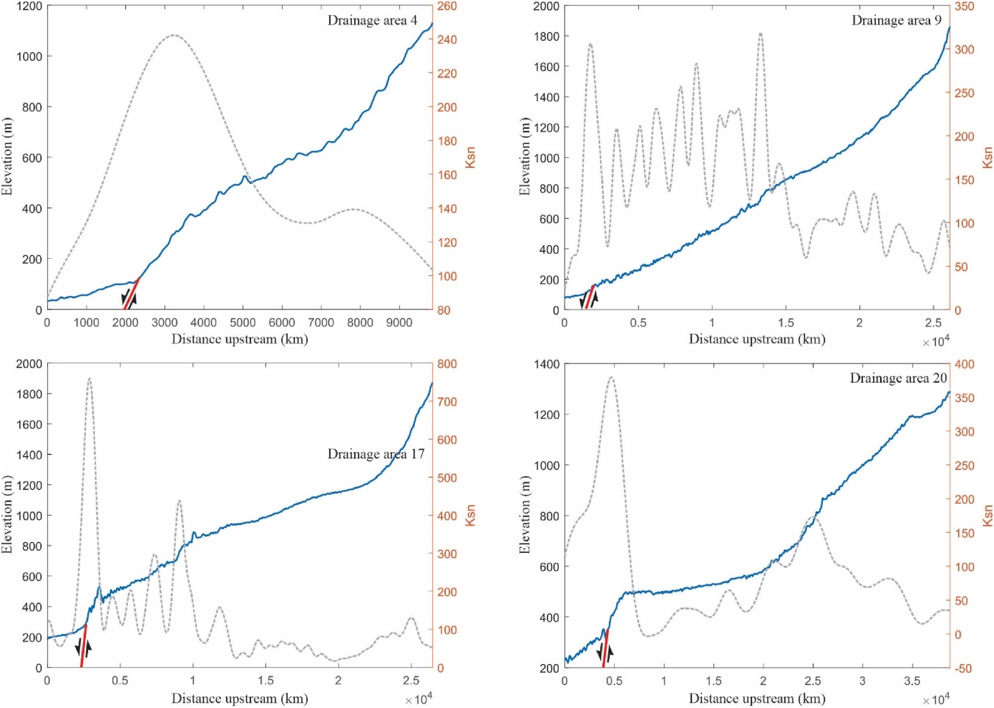
The Normalized Steepness Index (ksn), a proxy for differential uplift and incision rates, varies substantially across the fault zone. In the southern segment, Ksn values range from 82 to 190, with significantly high values in drainage areas 4 (177), 9 (160), 10 (178), and 11 (190), marking zones of steep gradients and intense fluvial incision, consistent with active tectonics. Lower Ksn values in areas 14 and 15 (97 and 82) reflect relatively subdued relief and tectonic quiescence. The remaining areas exhibit moderate Ksn values (95–143), indicating a balance between tectonic and erosional processes. In the northern segment, Ksn values range from 73 to 148, with drainage area 16 exhibiting the highest value (148), indicative of strong tectonic forcing. On the other hand, very low ksn values in areas 19 and 20 (73 and 76) suggest topographic stability. Intermediate values in areas 17, 18, and 21 (109–132) denote moderate activity levels (Table 2, Figures 4 and 5). The spatial distribution of ksn values aligns well with the Iat classifications: drainage areas 4 and 9–11 are designated Class 1, affirming their exposure to intense tectonic influence. Class 2 regions (e.g., 1–3 and 5–8) represent intermediate activity, while Class 3 areas (14, 15, 19, and 20) reflect less tectonic impact and more mature landscapes. This morphometric variability underscores the ongoing differential uplift and landscape response along the DIFZ. Ksn indices map applied along the main river courses of the drainage basins on the western flank of the Amanos Range, overlaid on a rock strength map (adapted from Selby, 1980). Rock strength categories are represented as follows: VH: very high (Ordovician clastics); H: high (Cretaceous neritic limestone, Mesozoic undifferentiated basic, and ultrabasic rocks); M: moderate (Eocene neritic limestone); L: low (Miocene clastics, limestone, and basalt, Quaternary alluvium). EAFS-DIFZ: East Anatolian Fault System-Düziçi-İskenderun Fault Zone; EAFS-AS: East Anatolian Fault System-Amanos Segment; EAFS-TS: East Anatolian Fault System-Toprakkale Segment; DSFZ-YS: Dead Sea Fault Zone-Yasemek Segment. Longitudinal profiles and Ksn index values of rivers within 21 drainage basins analyzed for morphometric studies along the Düziçi—İskenderun Fault Zone. Refer to Figure 5 for the locations of these drainage basins.
Gilbert metrics and χ
The integration of Gilbert metrics (elevation, mean upstream relief, and mean upstream gradient) with the Histograms of divide metrics (Gilbert metrics and χ) for the D1, D2, D3, and D4 segments. All calculations for Gilbert metrics and χ were performed beginning from the 300 m elevation level.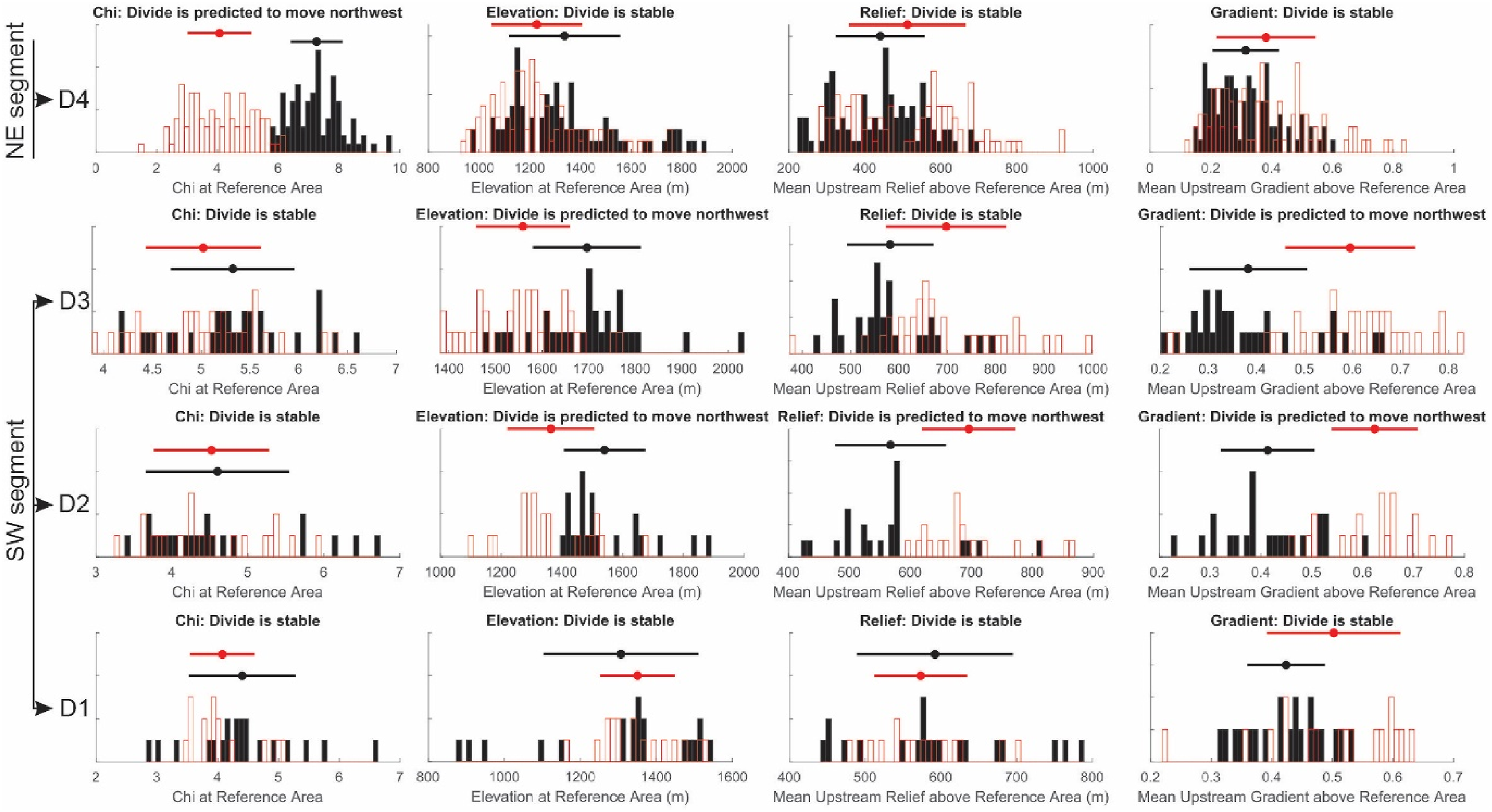
Metric to ongoing drainage reorganization processes, even when conventional elevation and relief measures appear balanced. A similar pattern emerges in segment D3, where
Triangular facets analysis
Estimated age and predicted vertical slip rate of mountain fronts along the Düziçi–İskenderun Fault Zone.
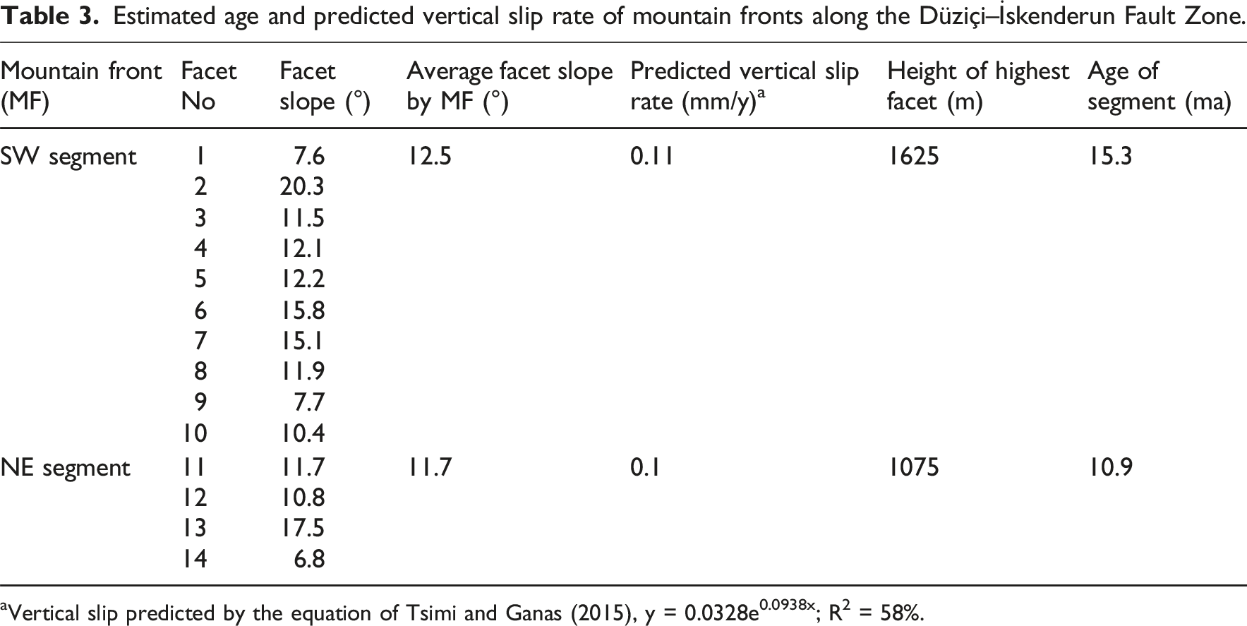
aVertical slip predicted by the equation of Tsimi and Ganas (2015), y = 0.0328e0.0938x; R2 = 58%.
Discussion
Tectono-geomorphic analysis
Tectono-geomorphic analysis provides a robust framework to decipher the interplay between active tectonics and surface processes, elucidating how structural deformation influences landscape evolution over time (Irfan et al., 2024a, b; Irfan et al., 2025a, 2025b). In this study, the integration of tectono-geomorphic techniques with paleoseismological investigations enables the identification of morphotectonic zones and the quantification of relative tectonic activity across the Amanos Mountains. This integrated approach not only enhances our understanding of landscape development but also informs seismic hazard assessment by providing an empirical basis for evaluating ongoing deformation patterns (Wani et al., 2025a, 2025b). The morphometric analysis presented in Section 4.1 reveals significant variability in several geomorphic indices, reflecting the differential influence of faulting, uplift, and erosion along the Düziçi–İskenderun Fault Zone (DIFZ). Spatial heterogeneity in these indices underscores the complex nature of tectonic forcing and surface response, highlighting areas of intensified tectonic activity versus regions dominated by erosional processes. Collectively, these observations confirm the presence of active tectonics and provide a quantitative framework for understanding the dynamic interplay between structural deformation and surface processes, which is essential for regional geomorphic and seismic hazard studies. These findings not only highlight the presence of active tectonic processes but also reveal the differential role of erosion, uplift, and faulting in landscape evolution.
Tectonic and morphological variability: A regional perspective
A key outcome of this analysis is the significant contrast between the southern and northern segments of the DIFZ in terms of tectonic activity and geomorphological characteristics. The southern section, which exhibits relatively low Smf values and higher Vf values, reflects areas where tectonic forces have been less dominant in recent geological history. This suggests that the landscape in this region has experienced more extensive erosional modifications, potentially due to older faulting or less recent tectonic activity. This observation aligns with Bull and McFadden (1977), who noted that regions with lower Smf values and wider valleys typically indicate older, less active fault zones, where erosional processes play a larger role. However, the higher Smf values in the northern segment suggest ongoing tectonic activity that maintains a sinuous mountain front. The increased sinuosity indicates an active fault zone, where tectonic forces continue to shape the landscape. This finding supports the work of Peltzer and Tapponnier (1988), who emphasized that fault zones with higher sinuosity are often associated with ongoing tectonic activity and less erosional modifications. The contrasting geomorphic characteristics between the two regions emphasize the regional variability of tectonic processes within the same fault system.
Role of faulting in drainage asymmetry and basin morphology
The analysis of Af and Bs provides further insights into the role of faulting in shaping drainage patterns. In the southern section, the variations in Af values reflect the influence of faulting on drainage asymmetry. High Af values indicate that active faulting has exerted a directional control over drainage, causing significant shifts in the flow direction. On the other hand, the northern section’s Af values, while still indicating faulting, exhibit less asymmetry, suggesting a balanced and stable drainage system in some parts of the region. The Bs values further reinforce the influence of faulting on basin morphology. The southern section’s higher Bs values (e.g., 8.25 in drainage area 8) indicate more elongated, fault-controlled basins, and the lower Bs values in the northern section (e.g., 2.14 in drainage area 19) reflect more rounded, mature basins. These contrasting shapes point to the regional differences in tectonic activity: while the southern section exhibits fault-controlled, elongated basins due to active tectonic processes. Similarly, the norther section exhibits more circular basins suggest areas where faulting is less active and basins have reached a more stable, mature form. This spatial variation in Af and Bs underscores the heterogeneous nature of tectonic forces along the DIFZ.
Insights into uplift and erosion
The HI values offer further evidence of the interplay between tectonic uplift and erosion in the DIFZ. The variability in HI values across the southern and northern sections reflects the regions ongoing tectonic processes. Higher values in the southern region, particularly in drainage areas 7 and 8 (e.g., 0.62 and 0.59), suggest ongoing topographic uplift and active faulting that contribute to the preservation of high-relief landscapes. On the other hand, lower values (e.g., 0.39 in drainage area 14) indicate more mature basins that have been modified by long-term erosion. In the northern section, higher Hi values (e.g., 0.61 in drainage area 16) suggest youthful, uplifted landscape that is still responding to tectonic forces, while the lower Hi values (e.g., 0.41 in drainage area 19) reflect more stable, mature topography. This variation highlights the differential rates of uplift and erosion, with regions of active tectonism exhibiting higher values due to the persistence of topographic relief and ongoing erosion (Molnar and Tapponnier, 1975). Similarly, the Ksn values, which represent the steepness of the landscape, indicate significant differences in tectonic activity between the southern and northern sections. The southern section, with its higher Ksn values (e.g., 177 in drainage area 4), points to areas with intense tectonic forcing and rapid fluvial incision, consistent with tectonically active landscapes. The northern section, with lower Ksn values (e.g., 73 in drainage area 19), reflects a more stable landscape with less active uplift. These steepness indices reflect the differential rates of uplift and erosion, with the southern section undergoing more rapid uplift and incision, while the northern section experiences a slower rate of tectonic activity.
Gilbert metrics and divide mobility
The integration of Gilbert metrics, such as mean upstream relief and mean upstream gradient with the
Triangular facets and long-term tectonic imprints
The calculation of slip rates using morphometric analyses, such as triangular facet geometry and facet slope, is a widely utilized approach in geomorphological and paleoseismological research (e.g., Akgün et al., 2025; Topal et al., 2016; Topal and Softa, 2023; Tsimi and Ganas, 2015). In this study, the analysis of triangular facets along the İskenderun–Düziçi Fault (DIFZ) within the Amanos Mountains provides critical geomorphic indicators of long-term tectonic activity and surface processes.
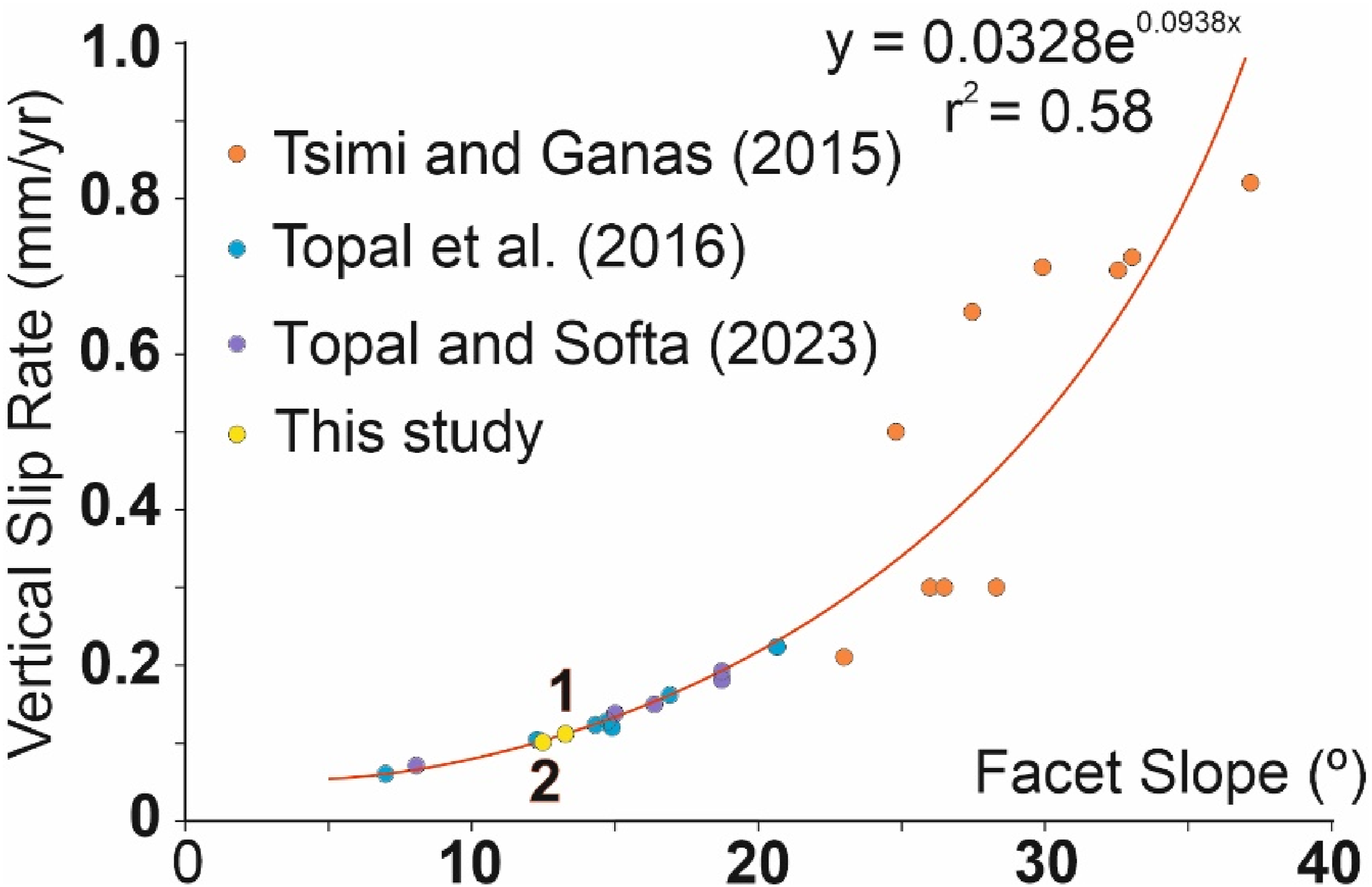
The observed moderate facet slopes (ranging between 7.6° and 20.3°) and the low vertical slip rates (e.g., 0.11 mm/year in the southwestern segment) indicate a tectonic regime characterized by slow deformation coupled with persistent erosion (Table 3, Figures 7 and 8). These findings are consistent with previous studies that associate gentle facet inclinations and low slip rates with mature, slowly evolving fault systems where erosional processes effectively mask or modulate the initial tectonic signal over extended timescales (e.g., Armijo et al., 1996; Burbank and Anderson, 2012). Furthermore, the estimated segmental age, such as 15.3 Ma for the southwestern segment, underscores the prolonged tectonic influence in this region. These results highlight the significance of integrating facet morphology with quantitative geomorphic metrics to capture the subtle but enduring imprint of long-term tectonic processes (Keller and Pinter, 2002; Wegmann and Pazzaglia, 2009). Triangular facets along the Düziçi–İskenderun Fault Zone. (a–c) Photographs captured by unmanned aerial vehicles, (d) satellite image obtained from Google Earth, and (e) a model illustrating the relationship between facet angle and relative age (F: triangular facets). EAFS-DIFZ: East Anatolian Fault System-Düziçi-İskenderun Fault Zone; Fw: Footwall; Hw: Hanging wall. Exponential relationship between facet slope and vertical slip rate, based on published data from Tsimi and Ganas (2015), Topal et al. (2016), and Topal and Softa (2023), as well as facet slopes along segments of the Düziçi–İskenderun Fault. Predicted vertical slip rate values likely represent minimum estimates.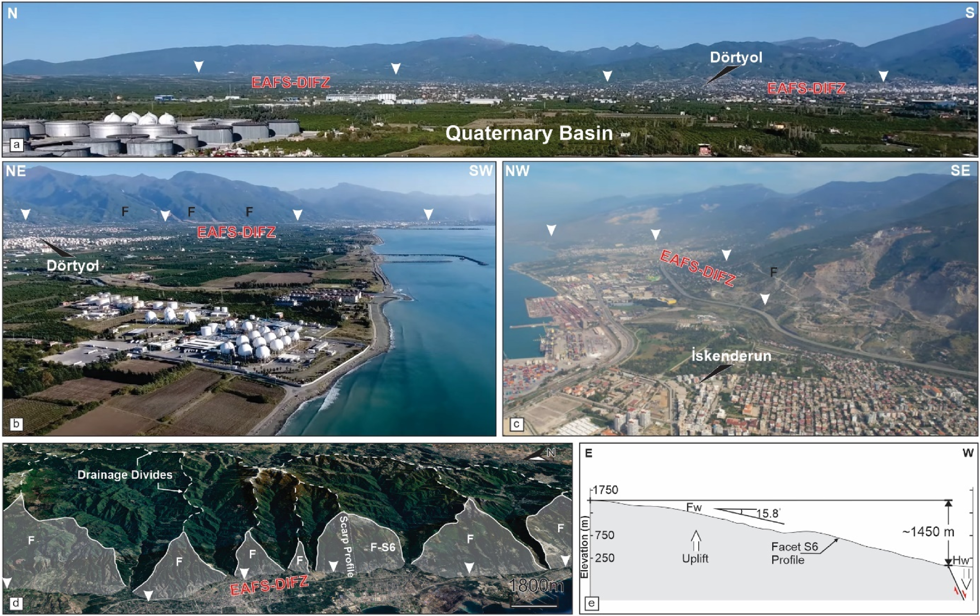
The apparent discrepancy between low slip rates and the high segmental age along the DIFZ, when compared to the formation age and lateral slip rate of the Eastern Anatolian Fault System (EAFS), suggests the calculated values could be underestimations based on certain assumptions. Two key factors may explain these irregularities:
1. Error Margin in Analytical Equations: The equation derived from Tsimi and Ganas (2015), which features a 42% error margin and a 58% significance level, may contribute to the observed lower vertical slip rates and higher formation age. This inherent uncertainty highlights the limitations of relying solely on morphometric analyses for precise slip rate determinations. 2. Inherited Structural Characteristics: The DIFZ may represent an inherited fault structure that has been reactivated from an earlier normal faulting regime into a strike-slip component compatible with the branches of the EAFS. If the DIFZ comprises an oblique-dip normal fault within the EAFS, whereas the adjacent Toprakkale and Amanos segment exhibits pure strike-slip behavior, this structural complexity could correspond to periods of tectonic stagnation and reduced slip rates during phases of deactivation prior to reactivation.
These findings suggest that the DIFZ’s low slip rates and high segmental ages may reflect overlapping periods of tectonic quiescence and erosion rather than continuous tectonic activity. Such interpretations reinforce the need for further multidisciplinary investigations to refine these estimates. To improve understanding of slip rates and formation ages along the DIFZ, trench-based paleoseismological studies, high-resolution seismic imaging, and geodetic analyses are strongly recommended. These methodologies would provide complementary datasets to enhance the accuracy of tectonic reconstructions and clarify the interplay between tectonic and surface processes in low-strain environments.
The relative tectonic activity of the Düziçi–İskenderun Fault Zone and its implications within the Eastern Anatolian Fault System (EAFS)
The assessment of relative tectonic activity along the DIFZ, based on morphotectonic basin analysis, reveals a structurally complex and tectonically active zone that plays a significant role within the broader EASF. The DIFZ, situated between the triple junction zone of the African, Arabian, and Anatolian plates, exhibits a predominantly high (H) level of tectonic activity across most of its drainage basins. However, a localized clustering of very high (VH) activity is observed in basins 4, 9, 10, 11, and 18 (Figure 9), areas spatially associated with fault interactions, topographic steepening, and pronounced geomorphic equilibrium. These basins coincide with critical segments where strike-slip motion along the DIFZ is coupled with transtensional or extensional components, suggesting localized zones of enhanced strain accumulation and active crustal reconfiguration. The central cluster (basins 9–11) reflects a structurally coherent domain likely accommodating significant shear strain, possibly acting as a mechanical linkage between segments of the DIFZ and adjacent structures. Basin 18, further north, presents an isolated VH zone, potentially indicating a discrete zone of uplift of fault-tip propagation. This spatial distribution of tectonic activity highlights the morphotectonic segmentation along the DIFZ, suggesting differential tectonic forcing and strain localization within the fault zone. The clustering of VH activity basins of the DIFZ suggests a non-uniform distribution of tectonic strain, indicating that the fault zone is not a monolithic structure but rather a segmented and dynamically evolving system. Such segmentation can influence rupture propagation behavior, potentially acting as barriers or nucleation points for future seismic events. This has direct implications for seismic hazard modeling, as the VH zones identified may correspond to zones of higher rupture potential and thus prioritized monitoring and risk mitigation efforts. Regionally, the DIFZ acts as a transitional structure between the left-lateral strike-slip regime of the EAFS and the more complex tectonic regimes of the Dead Sea Fault and the Cyprus Arc. The presence of multiple VH tectonic activity zones along the EAFZ suggests that this fault plays an active role in accommodating ongoing lithospheric deformation at the junction of all plates. This supports the interpretations of the DIFZ as an important kinematic link or secondary transfer zone within the broader EASF framework, helping to redistribute strain across the plate boundary. Moreover, the relative tectonic activity pattern aligns with broader geodynamic models that suggest strain partitioning and block rotation in southeastern Anatolia, with localized uplift, fault reactivation, and drainage reorganization serving as surface expressions of deeper crustal dynamics (Perinçek and Çemen, 1990; Yılmaz, 2020; Akgün et al., 2025; Yılmaz et al., 2025). Relative tectonic activity classes along drainage basins within the western flank of the Amanos Range. EAFS-DIFZ: East Anatolian Fault System-Düziçi-İskenderun Fault Zone; EAFS-AS: East Anatolian Fault System-Amanos Segment; EAFS-TS: East Anatolian Fault System-Toprakkale Segment; DSFZ-YS: Dead Sea Fault Zone-Yasemek Segment.
Paleoseismological interpretation of the southern and northern branches of the Eastern Anatolian Fault System (EAFS)
Considering the 2023 Kahramanmaraş earthquake pair, recent paleoseismological studies have significantly enhanced our understanding of the Surgu-Misis fault—identified as the northern strand of the East Anatolian Fault System (EAFS) by Duman et al. (2020). These studies have focused on active faults such as the Karatas, Yumurtalik, Toprakkale, and Düziçi–İskenderun faults, as delineated by Türkiye’s active fault map (Emre et al., 2013, 2018). Among these, the paleoseismological analysis conducted on the Düziçi–İskenderun Fault Zone, specifically at the Elbeyli (Düziçi segment) and Cona (Osmaniye segment) trenches, revealed evidence of at least four surface-rupturing earthquakes over the past 12–15 centuries (Duman et al., 2020).
The most recent seismic events identified in the Düziçi–İskenderun Fault Zone were linked to historical earthquakes: the AD 242 earthquake in the Osmaniye segment and the AD 1115 earthquake in the Düziçi segment. Unfortunately, due to insufficient data, precise recurrence intervals for these events could not be determined. Additionally, there remains a lack of paleoseismological studies for the Erzin and Payas segments of the Düziçi–İskenderun Fault Zone, leaving a critical gap in the holistic understanding of this fault system.
While Bayesian statistical approaches have been applied to determine earthquake recurrence intervals for segments of the EAFS (e.g., Pazarcik segment; Softa, 2024a), they have not yet been employed for the entirety of the Düziçi–İskenderun Fault Zone. Historical earthquake catalogs, though valuable for assessing the extent of damage in eastern Türkiye, remain problematic due to their reliance on eyewitness accounts and the uncertainty of location data. Addressing these limitations, Softa et al. (2023) highlighted the importance of employing advanced quaternary dating methods on faulted rocks and integrating Bayesian statistics to improve spatiotemporal analyses of seismic activity along active fault segments in Türkiye (e.g., Duran et al., 2021; Oncu et al., 2024; Şengöçmen Geçkin et al., 2022; Softa, 2024b).
Timing, interevent periods, and recurrence intervals in the Düziçi and Osmaniye segments of the East Anatolian Fault System.
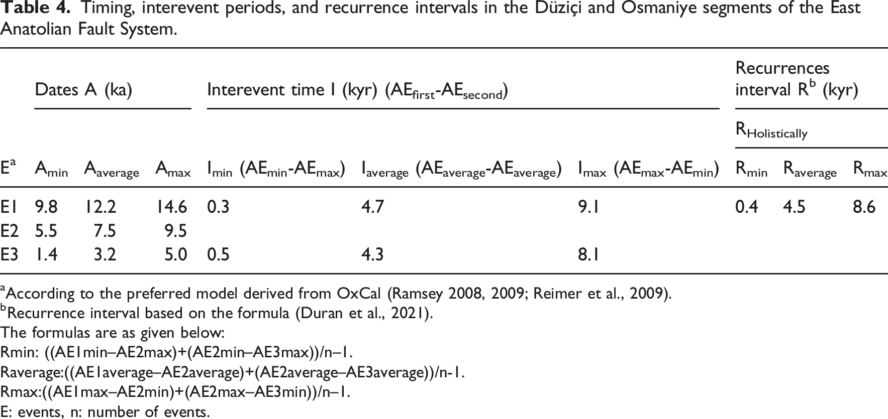
aAccording to the preferred model derived from OxCal (Ramsey 2008, 2009; Reimer et al., 2009).
bRecurrence interval based on the formula (Duran et al., 2021).
The formulas are as given below:
Rmin: ((AE1min–AE2max)+(AE2min–AE3max))/n–1.
Raverage:((AE1average–AE2average)+(AE2average–AE3average))/n-1.
Rmax:((AE1max–AE2min)+(AE2max–AE3min))/n–1.
E: events, n: number of events.
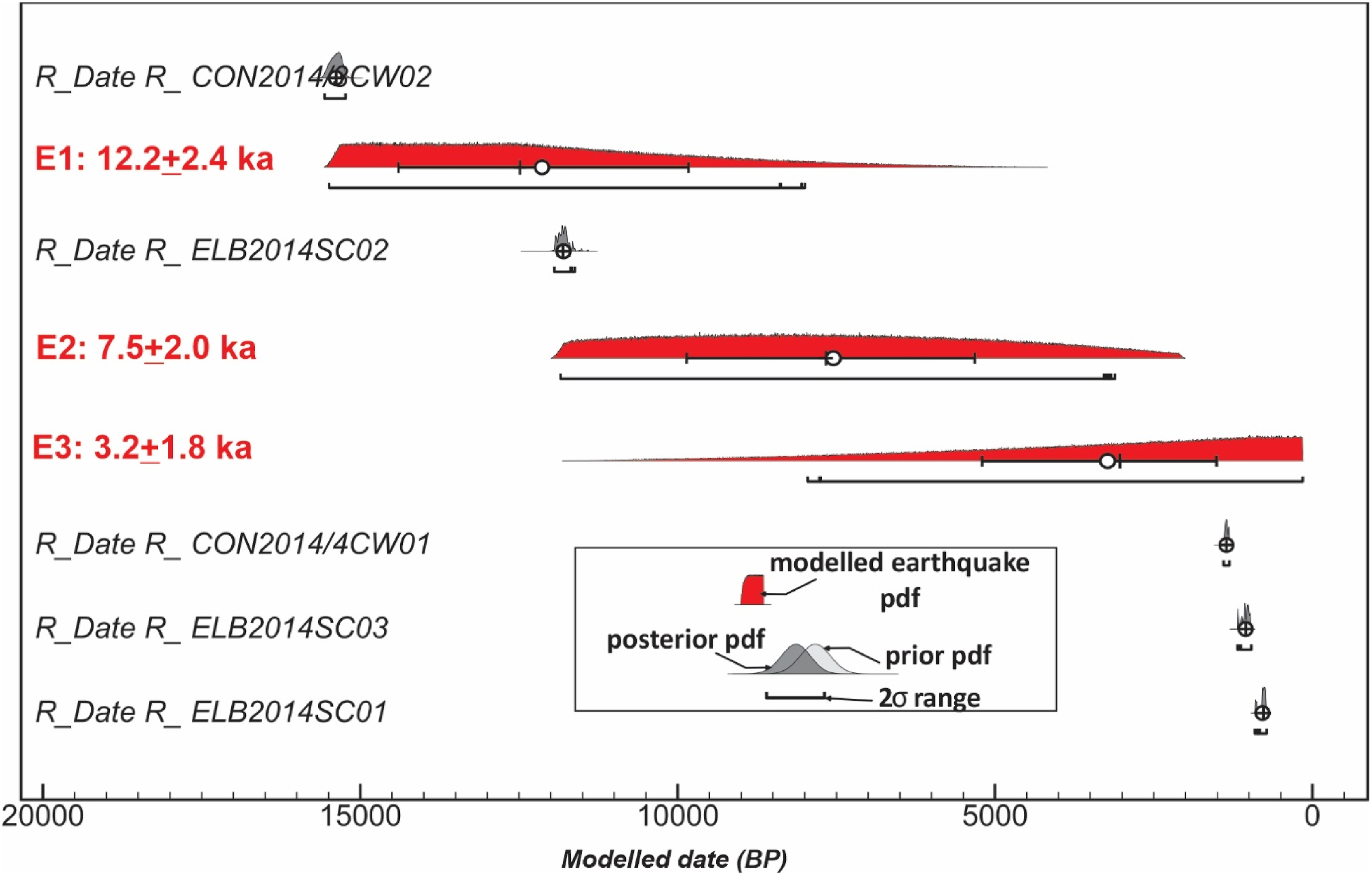
The framework (Ramsey 2008, 2009; Reimer et al., 2009) offers temporal restrictions regarding earthquakes (E1–E3) along the Düziçi and Osmaniye segments. The raw age data are compiled from Duman et al. (2020) paleoseismological trenches. Ages are listed sequentially, adhering to their stratigraphic sequence without depth limitations. Calibrated radiocarbon ages define prior probability distribution function (PDF) ages, while posterior PDF ages are computed through Bayesian OxCal analysis.
The seismic potential of the Düziçi–İskenderun Fault Zone further underscores the need for comprehensive studies. According to Duman and Emre (2013), the Düziçi and Osmaniye segments could generate earthquakes of up to magnitude 6.7, based on the empirical equations of Wells and Coppersmith (1994). Considering the overall average recurrence interval, these segments are classified as Class B faults under the Slemmons and Depolo (1986) system, indicating moderate activity with well-developed geomorphic evidence. This classification aligns with long-term slip rate estimates ranging from 0.1 mm/year to 1 mm/year, with rates calculated by Duman and Emre (2013) for the Düziçi–İskenderun Fault Zone being less than 1 mm/year.
In conclusion, it is strongly recommended that the Erzin and Payas segments of the Düziçi–İskenderun Fault Zone undergo detailed paleoseismological investigations to provide a holistic understanding of the EAFS. Such studies are critical not only for advancing scientific knowledge but also for developing urgent mitigation strategies to address seismic hazards effectively.
Conclusion
This study advances the understanding of the tectonic architecture and seismotectonic dynamics of the Amanos Mountains and the Düziçi–İskenderun Fault Zone (DIFZ). Morphometric analyses highlight significant spatial variations in tectonic activity along the fault zone, with differential uplift, incision, and erosion processes between the southern and northern segments. These geomorphic indicators corroborate the classification of the DIFZ as an actively deforming, structurally segmented fault system.
Previously conducted paleoseismological studies provide raw evidence of multiple surface-rupturing earthquakes in the Düziçi and Osmaniye segments over the past millennia, confirming long-term strain accumulation and moderate seismic potential. The integration of geophysical, morphometric, and paleoseismological data underscores the DIFZ’s role as a critical transitional structure within the broader Eastern Anatolian Fault System (EAFS), facilitating strain redistribution at the Anatolia–Arabia–Africa triple junction. Acting as a kinematic linkage between the EAFS, the Dead Sea Fault, and the Cyprus Arc, the DIFZ plays a key role in lithospheric dynamics and seismic hazard distribution.
These findings have direct implications for seismic hazard assessment in southeastern Türkiye. Identifying zones with heightened tectonic activity provides a foundation for focused geodetic monitoring and proactive earthquake preparedness. However, the absence of detailed paleoseismological data from the Erzin and Payas segments represents a significant knowledge gap. Addressing this gap should be a priority for future research, emphasizing systematic trenching, advanced chronometric techniques, and Bayesian statistical modeling to enhance earthquake chronologies and refine recurrence intervals. Such endeavors are essential to improving seismic hazard models and informing mitigation strategies for this tectonically active and densely populated region.
Footnotes
Acknowledgments
This study originates from the preliminary findings of the national earthquake project submitted to TÜBİTAK under the special issue framework by the first author as the Principal Investigator. The project was rigorously reviewed by TÜBİTAK, receiving assessments from ten anonymous referees within Turkey under project codes 124Y005 and 124Y185. The authors extend their sincere gratitude to these referees for their constructive critiques and evaluations, both positive and negative, which significantly enriched the research. Moreover, the devastating February 6, 2023 earthquake doublets profoundly motivated the authors to compile this manuscript, aiming to contribute meaningful insights to the academic community. The authors also sincerely thank the anonymous reviewers and editors for their constructive comments and insightful suggestions, which significantly improved the quality of the manuscript.
Author Contributions
Elif Akgün: Conceptualization, formal analysis, investigation, methodology, data curation, writing—original draft preparation, and writing—review and final editing. Mustafa Softa: Conceptualization, formal analysis, investigation, methodology, data curation, writing—original draft preparation, and writing—review and final editing. Mohammed Irfan: Methodology, writing—original draft preparation, and writing—review and final editing. Savaş Topal: Methodology, data curation, writing—original draft preparation, and writing—review and final editing.
Funding
The authors received no financial support for the research, authorship, and/or publication of this article.
Declaration of conflicting interests
The authors declared no potential conflicts of interest with respect to the research, authorship, and/or publication of this article.
Data Availability Statement
Topographic and elevation data were derived from the Advanced Land Observing Satellite (ALOS) Phased Array L-band Synthetic Aperture Radar (PALSAR) Digital Elevation Model (DEM), with a spatial resolution of 12.5 m, obtained from the Alaska Satellite Facility (ASF) at https://asf.alaska.edu. All maps and spatial datasets were georectified, georeferenced, and digitized using various Geographic Information System (GIS) software tools. Spatial analyses and map production were conducted using ![]() . All data used in this study are presented within the article. Additional datasets supporting the findings can be provided upon reasonable request to the corresponding author.
. All data used in this study are presented within the article. Additional datasets supporting the findings can be provided upon reasonable request to the corresponding author.