
Abstract
Eutrophication is a nutrient-driven shift in trophic status characterized by the appearance of green or blue green algae and declining water quality. Non-point source (NPS) pollutants are diffuse pollutants originating from multiple sources like agriculture runoff, urban waste, animal or human activities, etc. are major drivers of trophic transitions and algal proliferation. However, their seasonal influences on nutrient balance and trophic state remain understudied. This study provides an integrated framework combining water quality parameters, Carlson trophic state index (CTSI), Redfield ratio, and normalized differentiated chlorophyll index (NDCI) to understand the effect of NPS on nutrient loading and trophic transition across three major wetlands in Guwahati city, Deepor Beel, Dighalipukhuri, and Jorpukhuri during the post-monsoon season. Water quality parameters including temperature, pH, EC, TDS, DO, chlorophyll-a, NO3−, TKN, TN, TP, PO43−, and COD were analyzed from sampling points vulnerable towards NPS pollution across the wetlands. Results showed severe eutrophication intensity with CTSI values ranging from 113 to 115 in Deepor Beel, 110 to 114 in Dighalipukhuri, and 108 to 114 in Jorpukhuri. Redfield ratio of all the three wetlands indicated strong nitrogen dominance (TN/TP >16), with Deepor Beel showing highest spatial heterogeneity, while Dighalipukhuri and Jorpukhuri remain consistently phosphorus-limited across all points. Overall eutrophication intensity is highest in November across sites, with multiple hotspots exceeding TN/TP >50. NDCI mapping validated these findings, showing elevated chl-a concentrations along the pollution-prone margins of Deepor Beel. Across all wetlands, lower DO coincided with elevated chlorophyll-a, phytoplankton driven turbidity (Tchl-a > Tsd) and warmer post-monsoon temperatures are consistent markers of high eutrophication.
Keywords
Introduction
Wetlands are critical ecosystems that provide a wide range of ecological, hydrological, and socio-economic and cultural benefits (Dudgeon et al., 2006; GoI, 2017). Functioning as natural water purification systems, wetlands filter pollutants, sediments, and excess nutrients, thereby enhancing water quality. They also serve as vital biodiversity hotspots, supporting a wide range of plant and animal species, including many that are threatened or endemic (Dudgeon et al., 2006; Keddy, 2010; Sathe et al., 2020). The Anthropocene has introduced multiple novel and varied threats that disproportionately impact freshwater systems (Bahukhandi et al. 2025a, 2025b; Goswami et al. 2025a, 2025b; Kushwaha et al. 2024, 2025; Reid et al., 2019). A significant challenges include understanding how multiple diffuse nutrient sources such as runoff, domestic disposal, and informal and unregulated waste discharge interact to disrupt nitrogen phosphorus dynamics in wetlands causing problems like eutrophication, perpetuating the failure to meet stipulated water quality objectives (Bahukhandi et al., 2023; Hou et al., 2022; Khatri and Tyagi, 2015; Sathe et al., 2025; Wojtkowska and Bojanowski, 2021; Zhou et al., 2020). The complexity lies in identifying and controlling the sources of pollution. Now with effective regulations of point source pollution, the NPS pollution has emerged as one of the primary reasons for the degradation of global water quality (Devi et al., 2021; Hou et al., 2022; Zhou et al., 2021), given the inherent difficulty of identifying, quantifying, and managing these pollution sources (Xie et al., 2022).
Eutrophication is a critical environmental issue that disrupts the nutrient balance and quality of water (Akinnawo, 2023; Lencha et al., 2021). The surge in nutrient levels, especially nitrogen and phosphorus (Dodds and Smith, 2016), precipitates excessive algae and weed proliferation in water bodies, perpetuating different eutrophic states (Kroiss et al., 2011). The European Water Framework Directive (2000/60/EC) acknowledges eutrophication as a major impediment to achieving set water quality objectives, a sentiment echoed globally.
Guwahati, the largest city in Northeast India, hosts several urban wetlands, including the ecologically significant Deepor Beel. Recognized under the Ramsar convention is a place of high importance due to its ecological, cultural, and economic significance, and also an important habitat for migratory birds and diverse aquatic communities (Bhattacharyya and Kapil, 2010). But despite its protected status, the management of eutrophication remains insufficient. In Deepor Beel, the pollution studies highlighted the negative impact of heavy metals (Cr, Mg, and Fe) from point sources like the Boragaon dumping site and discharge from the Bashitha river (Dash et al., 2018, 2020; Kapil and Bhattacharyya, 2012). Also, recent trends highlighted human impacts in the form of illegal encroachment, unregulated discharges from agricultural lands which are fed by Bharalu and Bahini tributaries of the river Brahmaputra, two extremely polluted streams of the city contributing heavily to eutrophication. Seasonal studies also highlighted that degradation of water quality increases in post-monsoon season (Dash et al., 2021; Roy and Majumder, 2022). In comparison, other wetlands like Dighali Pukhuri and Jorpukhuri, which are also important for ecotourism and fisheries, have received far less scientific attention with a very limited number of studies (Das et al., 2002). Modern-day concerns also include the excessive use of fertilizers, leading to nutrient accumulation (nitrogen and phosphorus) (Bijay-Singh and Craswell, 2021) and subsequent runoff into water bodies, particularly during rainfall (Global Assessment of Soil Pollution: Report, 2021). In the contemporary urban landscape, water quality concerns of Guwahati escalade as its abundant wetlands suffer from contamination, rendering much of the water unfit for its ecosystem services (Kumawat et al., 2020).
Carlson Trophic status index (CTSI) is a comprehensive tool widely used to access the eutrophication status of lakes and wetlands using a regression relationship between Secchi depth (SD), chl-a, and total phosphorus (TP) (Carlson, 1977; Cunha et al., 2021; Shrestha and Malla, 2022). In eutrophication studies, although CTSI is widely accepted; however, a key limitation lies in its potential to misrepresent trophic status due to the effect of non-algal turbidity (NPS) (Klippel et al., 2020). Another significant limitation is that it does not specify the limiting nutrient causing eutrophication.
The Redfield ratio is a popular tool to investigate the nitrogen phosphorus dynamics. The Redfield ratio, which is 16:1 for nitrogen (N) to phosphorus (P), serves as a baseline for understanding nutrient dynamics in aquatic environments (Glibert and Burkholder, 2011; Ptacnik et al., 2010). Eutrophication often leads to nutrient loads that deviate from this ratio, resulting in altered phytoplankton growth patterns (Redfield, 1958). A higher ratio indicates a phosphorus-limited system, which means nitrogen is contributing to the algal boom and vice versa (Kroiss et al., 2011). Although eutrophication in urban wetlands is widely reported, the mechanistic link between NPS inputs and shifts in nutrient dynamics (TN/TP) remains poorly understood, especially in wetlands of various sizes and hydrological exposure. Additionally, the Redfield ratio, which is point based, provides information about the limiting nutrient but fails to capture the spatial extent and heterogeneity of eutrophication across the study area.
Several studies supported the advantage of remote sensing in eutrophication studies (Matthews et al., 2012; Ritchie et al., 2003; Shang et al., 2021; Vollenweider et al., 1998) (Annex Table 1). Chl-a is often used as an indicator of the trophic state of water (Buma and Lee, 2020), especially in remote sensing studies, because of its spectral activity (Beck et al., 2016; Mishra et al., 2014). Several remote sensing algorithms NDCI, 2BDA, and 3BDA were used for chl-a algorithms (Buma and Lee, 2020), but NDCI is a better performer in turbid productive water (Mishra and Mishra, 2012). However, one inherent limitation is that it can only detect surface and spectrally active parameters (e.g., chl-a); hence, there is no comprehensive information about the nutrient dynamics. Moreover, relying on the remote sensing index without ground validation introduces substantial uncertainties in the interpretations.
This raises a critical research gap in existing methodologies that assess overall trophic status but fail to spatially capture diffuse NPS impacts or resolve nitrogen–phosphorus dynamics driving localized algal blooms, which amplifies in the post-monsoon period. In this study, we address this gap through an integrated methodological framework combining water quality parameters, CTSI, Redfield ratio, and NDCI. Water quality parameters (pH, DO, COD, TN, TP, and chl-a) are first assessed to track trends and nutrient balance. CTSI then quantifies overall eutrophication, while the Redfield ratio (TN/TP) identifies the limiting nutrient. Finally, NDCI provides spatial validation by mapping chlorophyll-a hotspots, enabling precise identification of zones most vulnerable to non-point source pollution. This study aims to (i) identify and bridge the existing research gaps in the assessment of eutrophication processes in urban freshwater bodies of Guwahati city, (ii) formulate region-specific, adaptive management strategies considering the unique ecological, hydrological, and urban stressors of Guwahati, (iii) generate standardized, high-quality, and comparable water quality datasets for urban freshwater ecosystems, and (iv) synchronous monitoring initiative aimed at assessing eutrophication in the major freshwater bodies across Guwahati city. Ultimately, these findings will inform the development of a robust wetland restoration and management framework tailored to the unique needs of this region.
Study area
In the study, we addressed three important urban wetlands, namely, Deepor Beel (a Ramsar site, located at the outskirts of the city), the most important wetland in the region, along with Dighalipukhuri, and Jorpukhuri two places of great historical and touristic importance located at the heart of Guwahati city. These wetlands were chosen based on their varying sizes and ecological characteristics and importance, aiming to capture a spectrum of different wetland types prevalent in Guwahati.
Deepor Beel, situated in lower Assam between 26°05′N and 26°11′N latitude and 91°35′E and 91°43′E longitude, is a crucial habitat covering approximately 9.27 km2, with 4.1 km2 of the area being covered by water bodies. It serves as Guwahati city’s primary stormwater storage basin and is recognized under the Ramsar convention and as an important bird area recognized by Birdlife International. Pollution from municipal waste and untreated sewage has been threatening its ecological integrity for some time now (Choudhury and Gupta, 2017). Dighalipukhuri, a man-made pond in Guwahati, is an important ecotourism site of cultural importance, faces eutrophication issues, and is undergoing remediation efforts. Jorpukhuri, another historic pond in the area, also confronts eutrophication challenges and requires preservation efforts.
Materials and methods
This study proposes an integrated multistage framework to comprehensively evaluate wetland eutrophication and water quality in Guwahati city during the post-monsoon season. It starts with a reconnaissance survey to identify suitable sampling sites which are vulnerable to NPS pollution. Following site selection, water samples are to be meticulously collected and subjected to laboratory analysis to calculate the water quality parameters.
The Carlson trophic state index (CTSI) is a widely used tool that evaluates water quality based on parameters like chlorophyll-a (chl-a), total phosphorus (TP), and Secchi depth (SD) using equations (1)–(4), providing a quantitative measure of eutrophication (Carlson, 1977).


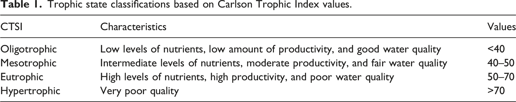
Trophic state classifications based on Carlson Trophic Index values.
The normalized differentiated chlorophyll indices (NDCI) were used for assessment of chlorophyll-a concentration and lake health assessment (Mishra et al., 2012a). Harmonized Sentinel-2A Level-2A surface reflectance dataset processed in Google Earth Engine (GEE), platform which inherently provides atmospheric corrected and reflectance normalized data via the Sen2C or processor for the study period (the entire post-monsoon season) and calculated monthly NDCI for November, January, and March month. The NDCI was calculated using the red band (B4, 10 m resolution) and the red-edge band (B5, 20 m resolution), with B5 subsequently resampled to 10 m to ensure spatial consistency before applying the NDCI equation using mathematical equation (5) (Mishra and Mishra, 2012). To maintain temporal consistency with field observations, only cloud free QA60 mask images from the corresponding sampling months were used for NDCI computation. The final NDCI raster was exported from GEE as geotiff files and converted to shapefiles in QGIS for spatial analysis of chlorophyll-a hotspots across the wetlands.
This structured approach aims to provide a holistic understanding of eutrophication transition and pollution dynamics within Guwahati’s wetlands in post-monsoon season, paving the way for effective management strategies.
Sampling framework
The present study comprehensively evaluated water quality and environmental conditions across various crucial parameters including pH, temperature, EC, TDS, DO, SD, PO43−, TP, TKN, nitrate, TN, COD, and chl-a. In total 11 water samples were collected from Deepor Beel, five distinct sampling sites within Dighalipukhuri, and four within Jorpukhuri (Figure 1) for assessment. Sampling locations were selected in plausible NPS pollution zones of the wetland, for example, in Deepor including the Bahini–Bharalu inflow points, the landfill-affected western margin receiving hill runoff near Boragaon dumping site, the central open-water zone, and the Khanajan outflow channel. For Dighalipukhuri and Jorpukhuri because of their smaller size, sampling points almost cover the whole area of the wetlands. Monthly samplings were performed in the post-monsoon season which is characterized by gradually receding water levels following monsoon flooding which is common in this part of the world. During this period nutrient rich sediments previously suspended by monsoon turbulence begin to settle, while diffuse nutrient inputs from urban networks and hill-slope runoff continue along with increased seepage from the nearby dumping site in case of Deepor Beel. This enhances nutrient retention, promoting phytoplankton growth and trophic transition. Study areas showing map location of sampling points of Deepor Beel, Dighalipukhuri, Jorpukhuri concerning Guwahati city, India.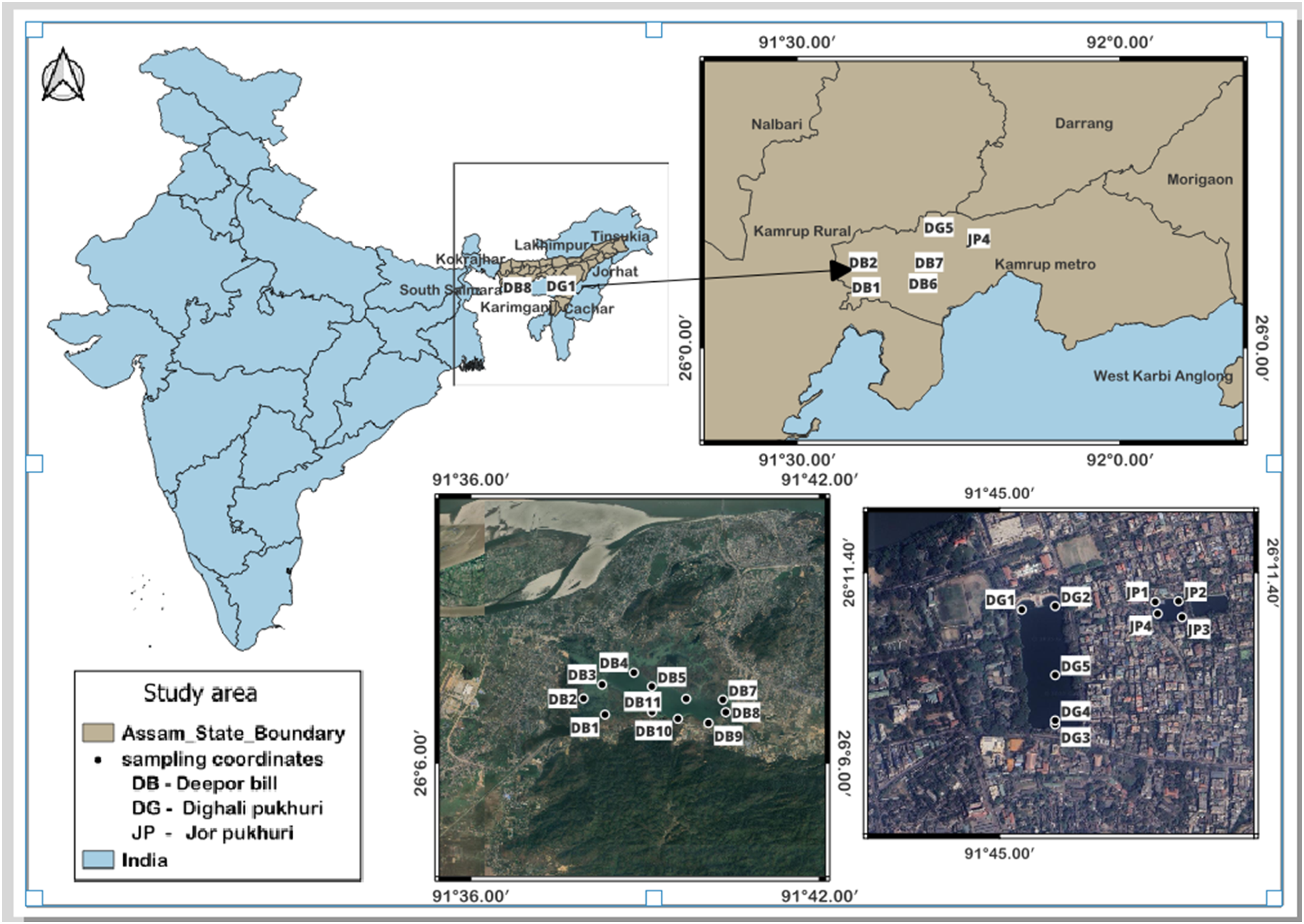
All containers were cleaned following established decontamination protocols (Rutala et al., 2008). The water samples were collected in triplicate at a depth of 0.5 m using a 1-L sampler, with separate acidified subsamples prepared for heavy metal analysis (Sathe et al., 2018; Sathe and Mahanata 2019). Instruments listed in (Annex Table 2) supported accurate measurement of all physicochemical parameters. Before analysis, samples were filtered to remove suspended impurities and diluted with deionized water when concentrations exceeded instrument ranges (Bulska and Ruszczyńska, 2017). Filtration was essential for preventing analytical interference, particularly with sensitive electronic instruments (Cescon and Jiang, 2020). Low-concentration samples were preserved through refrigeration or chemical stabilization to prevent physical, chemical, or biological alteration before analysis.
Analytical procedures
All the analytical procedures followed the APHA Standard Methods for the Examination of Water and Wastewater (APHA, 2005). Parameters prone to rapid change, such as pH and EC, were analyzed immediately upon sample receipt using a portable multiparameter water testing kit (YSI Inc. 550A, Sondes), while remaining analyses were conducted promptly with samples stored at 4°C to prevent alteration. Strict quality-control practices, including routine instrument recalibration and standardized reagent preparation, were maintained throughout the sampling. All chemicals were analytical grade, deionized water was used for all dilutions, and standard solutions were prepared from certified stock solutions to ensure accuracy and reproducibility (Hryniszyn et al., 2013).
pH of water sample
The collected water samples were analyzed by following the standard procedures prescribed in the American Public Health Association (APHA) (Sathe et al., 2021). After stabilization of electrical conductivity (EC), pH, and temperature, dissolved oxygen (DO) and oxidation–reduction potential (Eh) were measured in-situ using a portable multiparameter probe (YSI Inc., 550A Sonde). The pH determination process starts with the calibration of the pH meter (µ pH system 361) using two standard buffer solutions of pH 4.0 and 7.0 to ensure accuracy and reliability in measurements.
Electrical conductivity (EC) and total dissolved solids
The EC and TDS reflect the concentration of nutrients and the intensity of catchment runoff. The process for measuring electrical conductivity (EC) involves first calibrating the digital conductivity meter by measuring the temperature of the 0.1 N KCl solution, placing the cell into the 0.1 N KCl solution, and switching ON the instrument while selecting the 10 mΩ range. Extracting a 100 mL sample of water. The sample was then subjected to oven drying at 104°C for a period of 24 h. We then weighed the remaining residue after the drying process, which represents the total dissolved solids content present in the water sample.
Dissolved oxygen (DO)
Here, the DO measurement was conducted on-site using a multiparameter water testing kit (YSI Inc. 550A, Sondes), allowing for real-time assessment of the dissolved oxygen levels in the water.
Chemical oxygen demand (COD)
COD is frequently used to gauge organic pollutants (N-P source) present in wastewater and natural waters. The measurement of COD adhered to the method delineated in 5200 C (Closed Reflux, Titrimetric Method) within the Standard Methods for Examination of Water and Wastewater (Goswami et al., 2017).
Nitrates (NO3−)
The Nitrate (NO3−) is the dominant form of dissolved inorganic nitrogen in water bodies. The NO3− analysis was conducted following standard spectrophotometric procedures. A 50 mL clear sample was acidified with 1 mL of 1 N HCl, and calibration curves were prepared using diluted intermediate nitrate standards (0–35 mL volumes made up to 50 mL). Absorbance was measured at 220 nm for NO3−-N concentration and at 275 nm to correct for dissolved organic matter interference, ensuring accurate quantification.
Total Kjeldahl Nitrogen (TKN)
The determination of TKN in water involves assessing the quantity of nitrogen existing as organic nitrogen and ammonia nitrogen. Elevated TKN levels often indicate recent pollution in natural water sources. TKN measurement follows the procedure outlined in the method (U.S. EPA, 2016) or organic nitrogen in the Standard Methods for Examination of Water and Wastewater (APHA, 2008). However, in this modified process, the step involving the removal of ammonia before the digestion phase is omitted. This adaptation allows for a comprehensive assessment of both organic and ammonia nitrogen content without specifically isolating or eliminating the ammonia component before analysis.
Total nitrogen (TN)
TN comprises various forms, including Total Kjeldahl nitrogen (TKN), nitrite, and nitrate. Nitrite presence in surface water is typically minimal; thus, TN is often represented by the summation of nitrate and TKN concentrations (Roy and Majumder, 2022). As a fundamental macronutrient, nitrogen plays a central role in regulating primary production, particularly algal growth, within aquatic ecosystems.
Orthophosphates (PO43−)
Phosphorus in natural waters predominantly exists in the form of phosphates, which encompass orthophosphates, condensed phosphates (such as pyro, meta, and other polyphosphates), and organically bound phosphates. Orthophosphate, the most available form, plays a vital role in the growth of organisms and primary productivity in water bodies. Measurement of orthophosphates specifically follows the procedure outlined in method 4500-P E (Ascorbic acid method) (Koroleff, 1969) within the Standard Methods for Examination of Water and Wastewater (APHA, 2008). This method utilizes the Ascorbic acid technique to accurately quantify orthophosphate levels in water samples.
Total phosphorus (TP)
Total phosphorus includes both dissolved (orthophosphate + dissolved organic phosphate) and particulate forms. The diverse forms of phosphorus necessitate a digestion method to convert them into orthophosphates for accurate measurement. The “persulfate digestion method,” delineated in section 4500-P.B.5, was employed for this purpose. Subsequently, Orthophosphate was quantified following the previously described method, using a freshly prepared calibration curve. Standard solutions were hydrolyzed to enhance color development from introduced salts, allowing accurate measurement of orthophosphate concentrations (Ma et al., 2017).
Secchi depth transparency (SD)
The Secchi depth serves as an indicator of water clarity or turbidity in lakes, signifying the depth to which sunlight can penetrate through the water column. The growth of plants in water depends on sunlight availability; hence, they thrive only in areas where sunlight reaches (Liu et al., 2019). Water transparency, crucial for this sunlight penetration, relies on the quantity of particles suspended in the water. Essentially, higher particle levels lead to murky or cloudy water conditions and create light limitations. Conversely, lower water transparency correlates with a lower Secchi depth measurement, that is, higher algae concentrations.
Chlorophyll-a (chl-a)
The concentration of photosynthetic pigments, particularly chlorophyll-a (chl-a), serves as a critical indicator for estimating phytoplankton biomass. Chlorophyll-a constitutes approximately 1 to 2% of the dry weight of planktonic algae. To determine chl-a concentration, the spectrophotometric method outlined in section 10200 H.2.c of the Standard Methods for Examination of Water and Wastewater (APHA, 2008) was employed.
Calibration verification was performed using mid-range quality control (QC) standards for every 10 samples, with acceptance criteria of ±10%. Detection limits (LOD) and quantification limits (LOQ) were determined from repeated blank measurements (n = 10) using the 3σ and 10σ criteria. Analytical reproducibility was ensured by running all samples in triplicate; the relative standard deviation (RSD) remained below 2% for pH, EC, and DO, and below 5% for nutrient analyses. Field measurements were cross-checked with duplicate samples at 20% of the sites to minimize sampling uncertainty. Instrument drift was monitored by re-measuring the initial calibration standard after each analytical batch. Any drift beyond ±5% triggered recalibration. Collectively, these procedures ensured high analytical reliability, traceability, and quantifiable uncertainty across all parameters.
Results and discussion
The physicochemical and biological parameters calculated in the study reveal the N-P dynamics and trophic states of the wetlands by acting as ecological indicators.
Physicochemical properties
Spatial and average temporal fluctuations of water temperatures of Deepor Beel, Dighalipukhuri, and Jorpukhuri wetlands are illustrated in Annex Tables 3, 4, and 5. In November, January, and March, Deepor Beel exhibited mean temperatures of 22.91 ± 0.41°C, 17.01 ± 0.63°C, and 24.76 ± 0.55°C, respectively (Annex Table 3a). Dighalipukhuri recorded temperatures of 22.31 ± 0.11°C, 16.81 ± 0.33°C, and 23.37 ± 0.51°C (Annex Table 4a), while Jorpukhuri registered 22.19 ± 0.48°C, 16.36 ± 0.10°C, and 22.51 ± 0.98°C (Annex Table 5a) during the same months. Sampling activities spanned from pre-noon to late afternoon due to extensive coverage. This temperature variance likely influences species diversity dynamics, shapes the ecological structure and abundance of aquatic biota, significantly impacting ecosystem dynamics and functioning (Dallas, 2009), and high microbial respiration.
Annex Tables 3, 4, and 5 illustrate the spatial and average temporal fluctuations of pH of three different wetland locations, that is, Deepor Beel, Dighalipukhuri, and Jorpukhuri, respectively. In Deepor Beel, pH fluctuations were significant, ranging from 7.77 to 6.81 in November, 7.51 to 5.98 in January, and 7.21 to 5.75 in March, with the lowest recorded in March (Annex Table 3a). However, pH levels, particularly at sites DB8 and DB9, suggest the water’s potential acidity, likely influenced by nearby anthropogenic activities such as the Buragaon dumpsite and the Bahini river. Conversely, Dighalipukhuri maintained alkaline pH levels, ranging from 7.60 to 8.33 in November, 7.30 to 8.20 in January, and 7.40 to 8.11 in March (Annex Table 4a), indicating stability. Jorpukhuri exhibited consistent alkalinity, with pH ranging from 7.32 to 7.72 in November, 6.52 to 6.94 in January, and 6.84 to 7.21 in March, suggesting minimal fluctuation compared to Deepor Beel (Annex Table 5a). Conversely, Dighalipukhuri and Jorpukhuri maintain alkaline pH, indicative of less disturbance or buffering capacity from surrounding sources (Liu et al., 2006). The presence of high alkalinity is an indicator of higher CO2 consumption by the algal biomass. The pH strongly regulates the chemical form and biological availability of both nitrogen and phosphorus in aquatic systems. Under acidic conditions (low pH), nitrification is inhibited, causing ammonium (NH4+) to accumulate while the production of nitrate (NO3−) remains low. In contrast, alkaline conditions (high pH) favor the conversion of ammonium to ammonia (NH3), which can volatilize and escape from the water column; high daytime pH often signals intense algal photosynthesis and rapid internal nitrogen cycling. Phosphorus availability is also pH-dependent: at low pH, phosphate binds tightly with iron and aluminum compounds, reducing its bioavailability, whereas at high pH, phosphate is released (desorbed) from sediments, increasing internal phosphorus loading.
Annex Tables 3, 4, and 5 show distinct seasonal and spatial patterns in EC across the wetlands, evaluated against the BIS threshold of ≤750 µS/cm (Durairaj et al., 2014). Deepor Beel exhibited the widest variability, ranging from 203 to 458 µS/cm (November), 232 to 473 µS/cm (January), and 234 to 477 µS/cm (March), with consistently elevated values at DB8 and DB9 due to inputs from the Boragaon dumpsite, the Bharalu/Bhaini inflow, and nearby industrial activity. Higher EC in the dry months reflects ionic concentration under reduced water volume (Dey et al., 2021).
Dighalipukhuri showed moderate seasonal fluctuations 243 to 294 µS/cm (November), 279 to 331 µS/cm (January), and 285 to 308 µS/cm (March) with localized elevation near the lakeside eatery (Balakrishnan and Selvaraju, 2014). Jorpukhuri maintained a narrow, stable EC range (452–462 µS/cm), likely due to efficient mixing within its small basin despite continued organic and ionic loading from ritual activities. Overall, EC differences across systems reflect hydrological variation, runoff patterns, and site-specific anthropogenic pressures (Das and Gupta, 2012).
As shown in Annex Tables 3, 4, and 5, TDS levels also varied seasonally across the wetlands. Deepor Beel recorded 102 to 229 mg/L (November), 116 to 237 mg/L (January), and 117 to 240 mg/L (March). Dighalipukhuri exhibited values of 122 to 146 mg/L, 140 to 166 mg/L, and 143 to 165 mg/L across the same months, while Jorpukhuri showed a narrow, consistently higher range of 226 to 231 mg/L. TDS values generally peaked during the dry season due to evaporative concentration. Importantly, TDS across all sites remained well within BIS permissible limits (≤500 mg/L).
Correlation coefficient matrix for Deepor Beel sampling site.

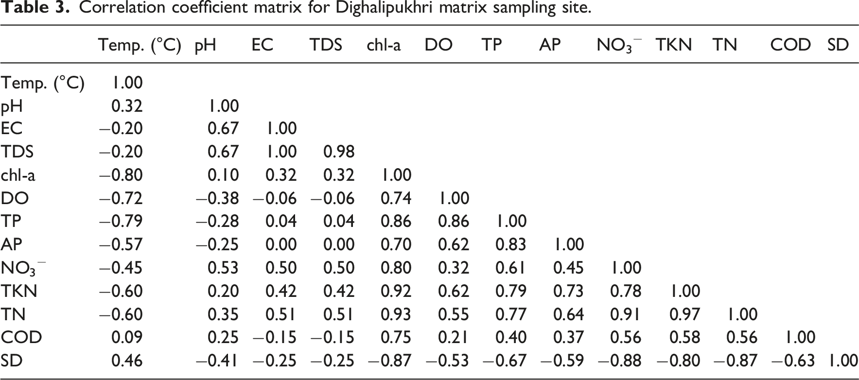
Correlation coefficient matrix for Dighalipukhri matrix sampling site.
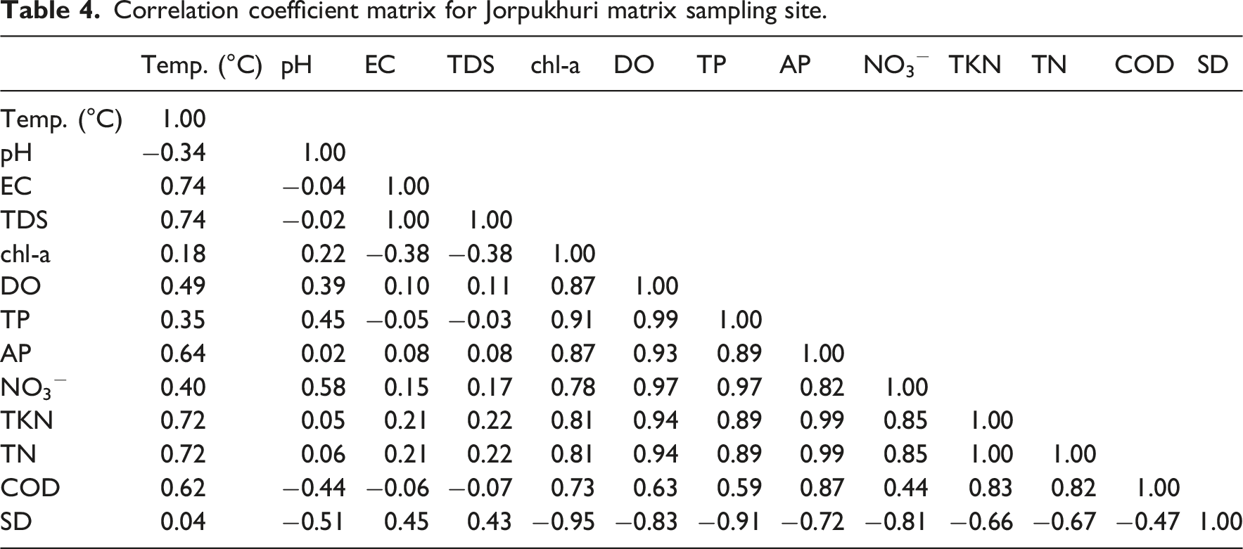
Correlation coefficient matrix for Jorpukhuri matrix sampling site.
Nitrates (NO3−)
Nitrate serves as an indicator of age pollution, fully oxidized over time. Annex Tables 3, 4, and 5 depict the spatial and temporal variation of nitrate (NO3−) concentration at three different locations. At Deepor Beel, nitrate concentrations varied seasonally, with November ranging from 0.001 to 0.662 mg/L, January from 0.042 to 0.737 mg/L, and March from 0.075 to 0.599 mg/L (Annex Table 3c). Particularly high levels in sites DB5 and DB6 coincide with abundant water hyacinth growth, indicating potential eutrophication (Abascal et al., 2022). Dighalipukhuri exhibited varying nitrate levels, ranging from 0.001 to 0.195 mg/L in November, 0.572 to 0.810 mg/L in January, and 0.474 to 0.583 mg/L in March (Annex Table 4c). Similarly, Jorpukhuri showcased fluctuations, with November concentrations between 0.158 and 0.208 mg/L, January between 0.632 and 0.752 mg/L, and March between 0.612 and 0.622 mg/L (Zendehbad et al., 2022) (Annex Table 5c).
Total Kjeldahl nitrogen (TKN)
Annex Tables 3, 4, and 5 illustrate the temporal fluctuations of TKN in Deepor Beel, Dighalipukhuri, and Jorpukhuri across November, January, and March. TKN encompasses free ammonia and organic ammonia, where free ammonia signifies recent pollution and organic ammonia denotes nitrogen content before decomposition. In the present study at Deepor Beel, the high concentration of TKN was witnessed. This could be attributed to the fact that the Buragaon dumpsite is located close to Deepor Beel and the city’s wastewater is entering the wetland, which continues to bring in more nitrogen content. The TKN concentration in the sampling sites DB8, DB9, and DB10 has always remained high due to their proximity to the dumpsite and also due to the presence of small industries nearby. The average TKN concentration was reported to be highest in the month of March. TKN concentration in the month of November ranged between 11.75 and 18.20 mg/L, in the month of January it ranged between 12.77 and 18.80 mg/L, and in March concentrations ranged between 14.16 and 18.37 mg/L (Annex Table 3c). Similarly, Dighalipukhuri and Jorpukhuri also displayed elevated TKN concentrations, suggesting common regional influences.
Total nitrogen (TN)
Annex Tables 3, 4, and 5 illustrate the seasonal variation of TN across Deepor Beel, Dighalipukhuri, and Jorpukhuri exceeding hyper-eutrophic state (>1.5 mg/L) (OECD, 1982; US EPA, 2000). TN increased steadily toward March, indicating a strong seasonal influence. Deepor Beel showed TN ranges of 11.81 to 18.20 mg/L (November), 13.14 to 19.32 mg/L (January), and 15.41 to 18.72 mg/L (March) (Annex Table 3c); Dighalipukhuri recorded 13.60 to 16.31 mg/L, 15.88 to 18.97 mg/L (Annex Table 4c), and 16.73 to 19.23 mg/L; while Jorpukhuri showed 11.37 to 15.61 mg/L, 13.19 to 18.15 mg/L, and 14.03 to 16.40 mg/L (Annex Table 5c) over the same periods. TKN (organic N) overwhelmingly dominated the nitrogen pool (11.75 to 18.80 mg/L), peaking in March, indicating that organic and particulate N are the principal contributors to elevated TN. High TKN at DB8–DB10 reflects inputs from the dumpsite and industrial discharges, confirming that most NPS pollution enters as raw sewage and decomposing organic waste. In contrast, nitrate (
Total phosphorus (TP)
Annex Tables 3, 4, and 5 illustrate total phosphorus across three wetlands exceeding the eutrophic level (>0.025 mg/L) (OECD, 1982; US EPA, 2000). In Deepor Beel, total phosphorus levels ranged from 0.27 to 1.91 mg/L in November, with notably elevated concentrations near the Buragaon dumpsite, indicating a potential point source of pollution. During January and March, the average total phosphorus concentrations were notably high, ranging from 0.32 to 1.57 mg/L and 0.35 to 1.59 mg/L, respectively (Annex Table 3b). Similarly, at Dighalipukhuri wetlands, total phosphorus concentrations ranged from 0.188 to 0.284 mg/L in November, with elevated levels observed during January and March, ranging from 0.58 to 0.67 mg/L and 0.51 to 0.57 mg/L, respectively (Annex Table 4b). Likewise, Jorpukhuri wetland exhibited total phosphorus concentrations ranging from 0.2 to 0.262 mg/L in November, with elevated levels during January and March, ranging from 0.54 to 0.62 mg/L and 0.53 to 0.63 mg/L, respectively (Annex Table 5b).
Orthophosphate (PO43−)
The variation in orthophosphate (PO43−), that is, the available phosphorus (AP) concentration across Deepor Beel, Dighalipukhuri, and Jorpukhuri, highlights key patterns in nutrient dynamics within these ecosystems, as depicted in Annex Tables 3, 4, and 5. In the present study at Deepor Beel sites, the PO43− is found to be 0.6 to 0.8 times that of total phosphorus, indicating a substantial bioavailable phosphorus pool. The concentration of PO43− in the month of November was reported to be within the range of 0.20 to 1.29 mg/L (Annex Table 3b), in January it was reported between 0.30 and 1.34 mg/L, and in the month of March the concentration was between 0.21 and 1.41 mg/L. High values were again reported in DB8 and DB9 (Annex Table 3b).
The orthophosphate at Dighalipukhuri showed the same trend as total phosphorus, with the average concentration increasing in the months of January and March. The concentration of (PO43−) in the month of November was reported to be within the range of 0.137 to 0.179 mg/L, in January, it was reported between 0.4 and 0.473 mg/L (Annex Table 4b), and in March, the concentration was between 0.315 and 0.365 mg/L. The available phosphorus or orthophosphate in the present study is mostly found to be 0.65 to 0.8 times than that of total phosphorus at Jorpukhuri. The available phosphorus also showed the same trend as total phosphorus, with the average concentration increasing in January and March, as shown in Annex Tables 3, 4, and 5. The concentration of PO43− in November was reported to be within the range of 0.158 to 0.177 mg/L, in January, it was reported between 0.413 and 0.498 mg/L, and in March, the concentration was between 0.413 and 0.454 mg/L (Annex Table 5b).
Chemical oxygen demand
Annex Table 3,4,5 shows clear spatial and seasonal variation in COD across the three wetlands. Deepor Beel exhibited the high COD levels, ranging from 22.56 to 68.18 mg/L in November, 45.51 to 98.20 mg/L in January, and 61.22 to 100.50 mg/L in March (Annex Table 3c) with persistent peaks at DB8–DB9 due to inputs from the Boragaon dumpsite (Roy and Majumder, 2022). Dighalipukhuri showed moderate COD values (22.56 to 68.18 mg/L in November, 41.56 to 60.31 mg/L in January, and 47.50 to 62.74 mg/L in March) (Annex Table 4c), whereas Jorpukhuri consistently recorded the lowest values (10.20 to 15.20 mg/L, 13.84 to 22.00 mg/L, and 16.03 to 20.89 mg/L) (Annex Table 5c), indicating comparatively limited organic pollution. COD generally increased from November to March across sites, likely reflecting reduced water volume and intensified organic loading. These patterns highlight differing levels of anthropogenic influence among the wetlands (Sharma and Bora, 2020).
Secchi depth transparency
Annex Tables 3, 4, and 5 show that Secchi Disk (SD) depths exhibited clear seasonal patterns across the three wetlands. In Deepor Beel, transparency remained low throughout the study (0.42 ± 0.11 m in November, 0.40 ± 0.15 m in January, and 0.34 ± 0.08 m in March) (Annex Table 3c), with SD depths in January and March across sites likely reflecting increased nutrient loading and macrophyte growth during winter months (Liu et al., 2019). Dighalipukhuri displayed similar patterns (0.43 ± 0.04 m, 0.39 ± 0.06 m, and 0.41 ± 0.05 m) (Annex Table 4c), while Jorpukhuri maintained slightly higher clarity (0.49 ± 0.05 m, 0.45 ± 0.05 m, and 0.47 ± 0.06 m) (Annex Table 5c). Notably, locations near dumpsites consistently recorded the lowest transparency, underscoring the impact of anthropogenic pollution on water clarity.
Chlorophyll-a (chl-a)
Annex Tables 3, 4, and 5 show chl-a across the three wetlands exceeding the eutrophic limit 0.1 mg/L (OECD, 1982), with concentrations peaking in January, reflecting winter-driven enhancement of algal growth (Borah and Hazarika, 2023). In Deepor Beel, chl-a ranged up to 0.553 mg/L in November and increased to 0.123 to 0.690 mg/L in January (Annex Table 3c), while DB8 consistently showed the lowest values due to stressful conditions near the Boragaon dumpsite. In Deepor Beel, chl-a also correlated positively with TP, TN, COD, and DO, as shown by the correlation coefficient matrix (Tables 2–4). Dighalipukhuri exhibited higher chl-a overall, reaching 0.410 to 1.040 mg/L in January (Annex Table 3c), likely due to elevated nutrient availability. Jorpukhuri showed similar seasonal trends but with comparatively lower concentrations. These patterns collectively reflect nutrient-driven algal responses across the wetlands.
Trophic state index
Trophic level is a key indicator of water quality in aquatic ecosystems, reflecting productivity, biomass, and nutrient enrichment, which can range from oligotrophic to hyper-eutrophic states. Using average SD, TN, TP, and chl-a, the TSI (in Figure 2) show that the Deepor Beel, Dighalipukhuri, and Jorpukhuri remain in a consistently hyper-eutrophic state throughout the study period. Across all wetlands, the extreme Trophic state index at Deepor Beel, Dighalipukhuri and Jorpukhuri.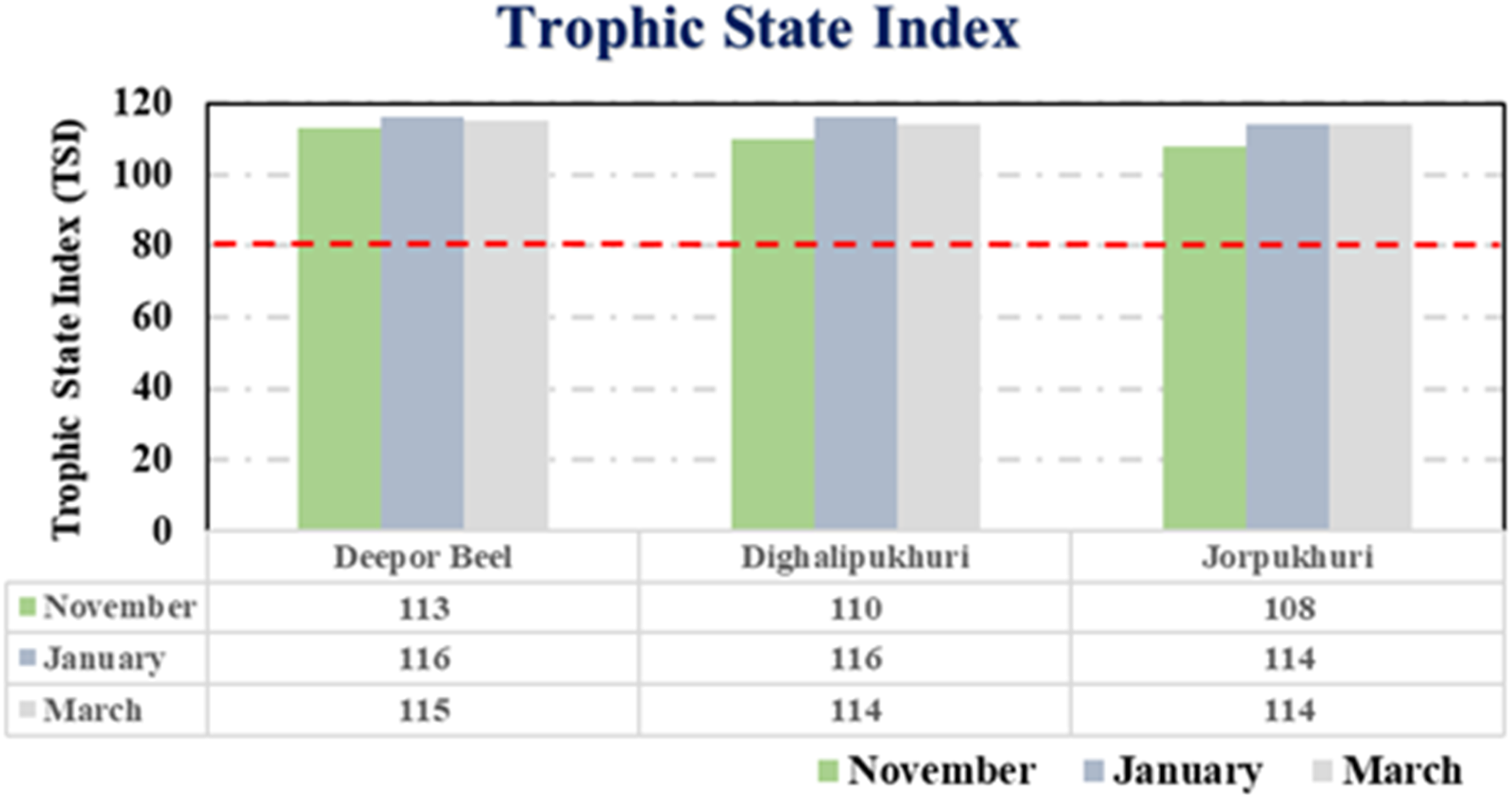
Redfield ratio
The TN/TP ratios across the study sites provide clear evidence of nutrient imbalance. In Deepor Beel (Figure 3(a)), ratios generally exceed the Redfield threshold (>16:1), indicating nitrogen excess and phosphorus limitation, except near the Boragaon dumpsite (DB7–DB9), where altered inputs lower the ratios. Similar patterns in Dighalipukhuri and Jorpukhuri (Figure 3(b) and (c)) confirm consistent phosphorus limitation across all wetlands. Redfield ratio (a) Deepor Beel, (b) Dighalipukhuri, and (c) Jorpukhuri.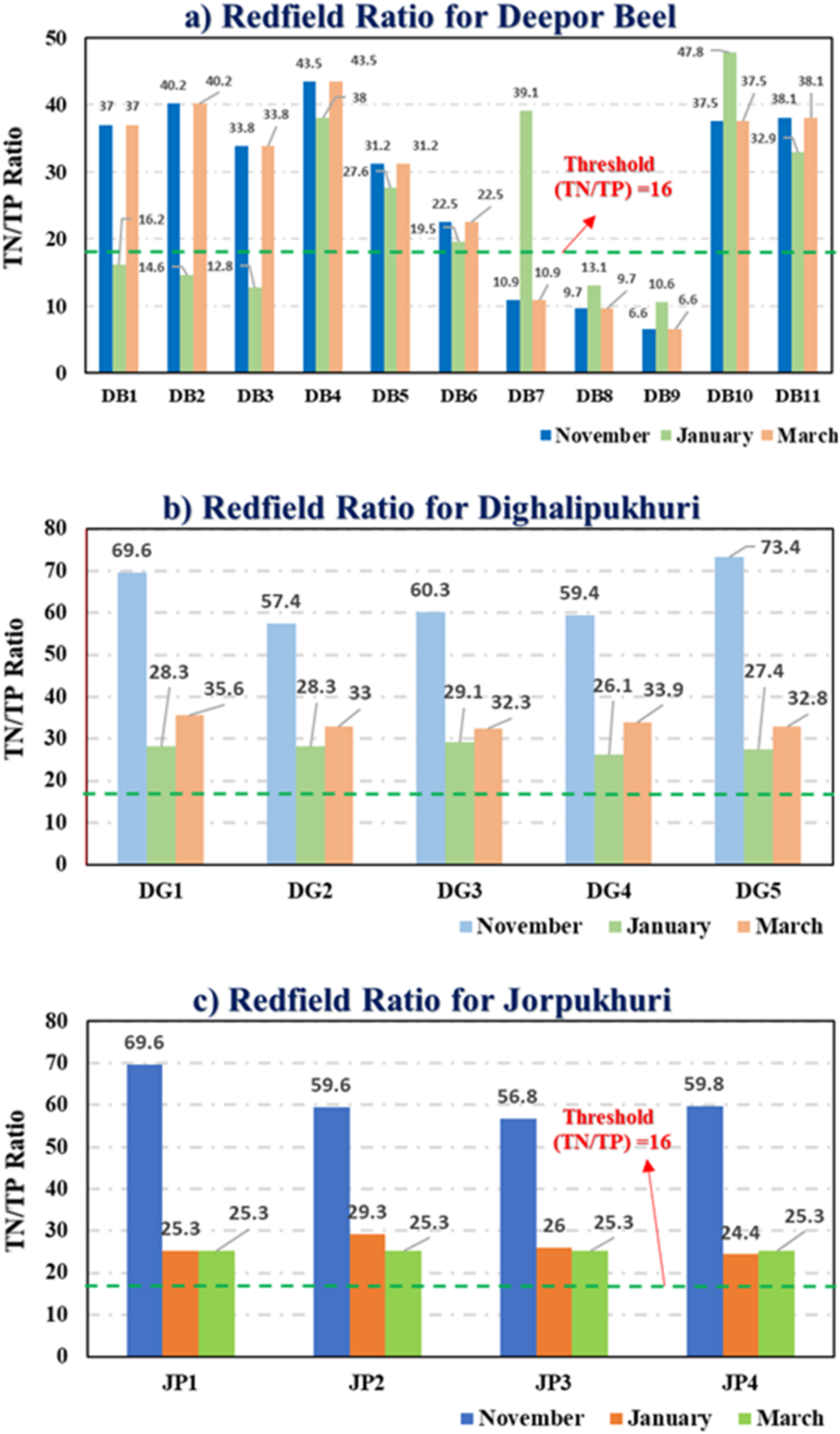
Sustained hyper-eutrophic conditions align with the persistently high
Remote sensing analysis
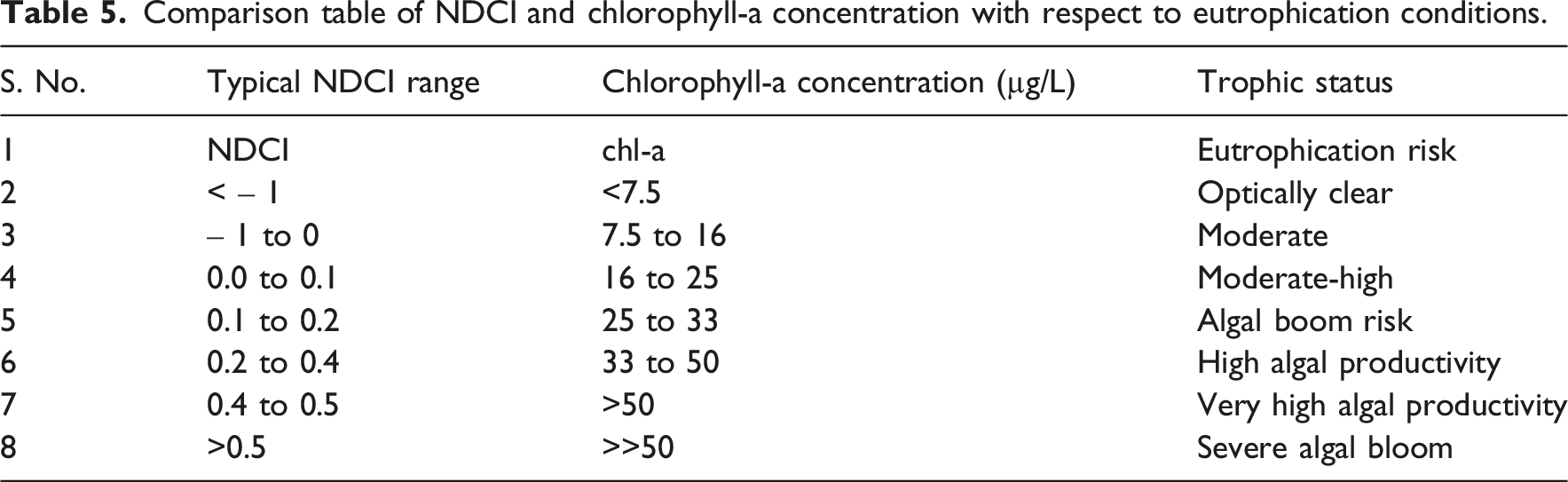
Comparison table of NDCI and chlorophyll-a concentration with respect to eutrophication conditions.
The results as shown in Figure 4 depicted high levels of NDCI values in around the sampling sites of Deepor Beel during the peak monsoon (Northeast monsoon), that is, in November is lower than the post-monsoon, that is, from (January–March). It could prove our initial hypothesis about the increased risk of eutrophication, especially in the post-monsoon period. It could be the result of an increase in surface runoff from non-point pollution sources, along with the decomposition of the organic matter coming from the sources. Also, after the rainy monsoon period, the tributaries of the Brahmaputra River carry a lot of sediments with them, which could plausibly change the nutrient concentrations. The NDCI for the major part of the lake is in strong agreement with the in-situ chl-a value, providing a satisfactory qualitative validation towards the high risk of eutrophication. NDCI index for Deepor Beel for the month (a) November, (b) January, and (c) March.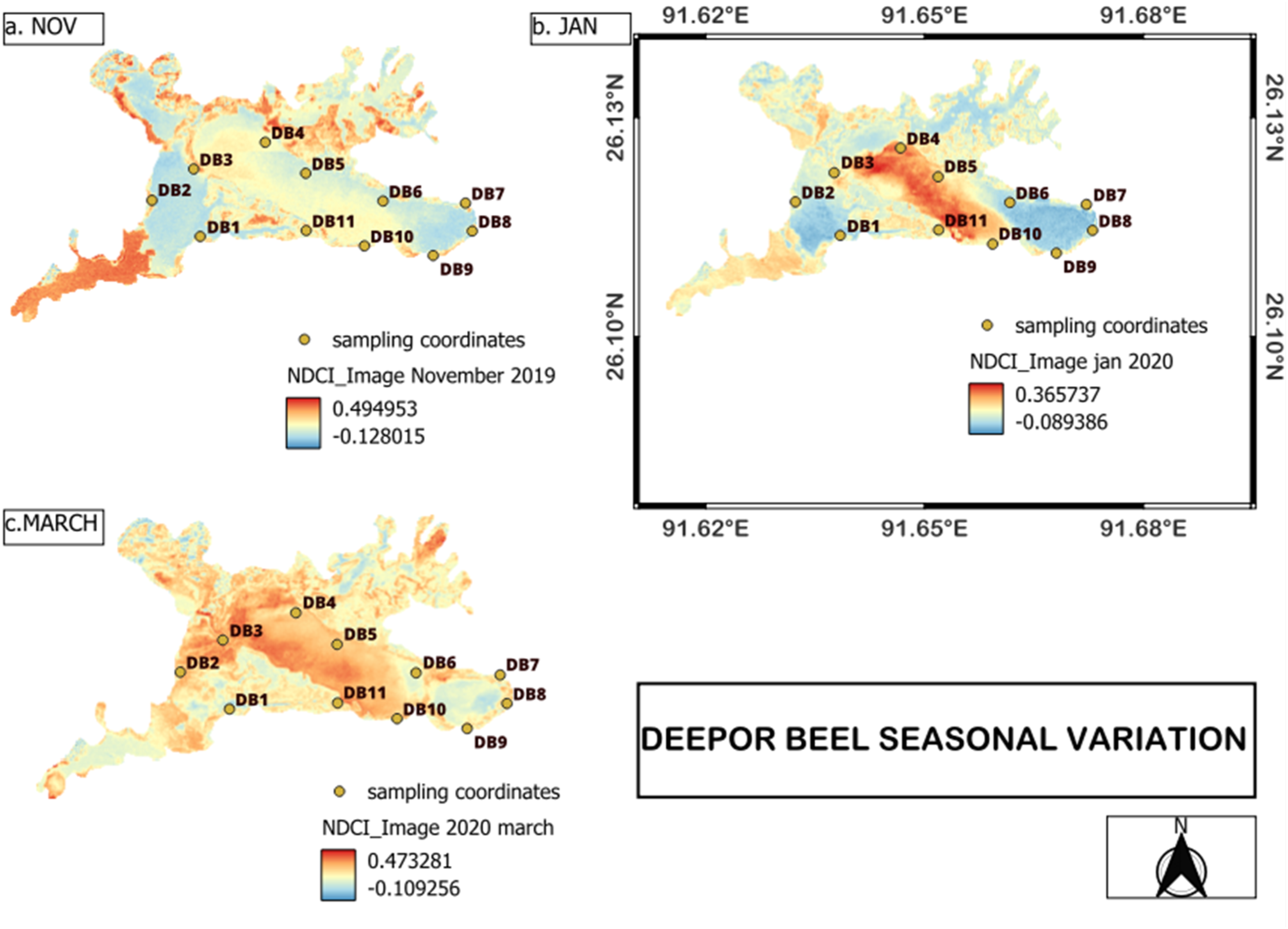
For effective restoration and management of these wetlands requires science based precise management strategies, with site-specific interventions and active participation of all stakeholders involved. Restoration measures should include regulation of dumping, improved medical and electronic waste treatment, and routine water quality monitoring. Under instruments such as the Wetlands (Conservation and Management) Rules, 2017 (Shan et al., 2021) and commitments to the Ramsar Convention, nutrient reduction strategies must prioritize phosphorus abatement, strict regulation of non-point source (NPS) runoff, and protection of designated buffer zones. These policies mandate restrictions on encroachment, waste dumping, and untreated discharge, yet implementation gaps remain a critical barrier (Ramsar Convention Secretariat, 2008).
For long-term sustainability, restoration frameworks must incorporate catchment-scale governance, linking watershed management with wetland conservation, while embedding tools like CTSI, Redfield ratio, and NDCI into regulatory monitoring protocols (Gell et al., 2023; Redfield, 1958). Strengthening compliance, institutional coordination, and accountability mechanisms will be essential to ensure effective implementation, particularly for ecologically sensitive systems such as Deepor Beel.
Conclusions
This study accesses the nutrient dynamics and trophic state of three key wetlands in Guwahati city, India. Deepor Beel, Dighalipukhuri, and Jorpukhuri, all exhibiting severe trophic state. Extremely high TN indicates strong nitrogen-dominated NPS inputs, largely organic in nature, reflected by elevated TKN. Alternately Orthophosphate (60–80% of TP) also exceeds eutrophication thresholds. Physiochemical parameters supported the high eutrophic condition. High chl-a and alkaline pH confirmed aggressive primary production, positively correlated with nutrient (TP and TN), moderate temperature and fluctuating DO signaling towards oxygen stress and transient hypoxia. The comparison of TSI components suggests that reduced transparency is driven largely by phytoplankton biomass rather than inorganic turbidity (
Supplemental material
Supplemental Material - Eutrophication and water quality assessment due to non-point pollution sources using tropic status and remote sensing index of wetlands in Guwahati city, India
Supplemental Material for Eutrophication and water quality assessment due to non-point pollution sources using tropic status and remote sensing index of wetlands in Guwahati city, India by Tapash Mazumdar, Sandip S. Sathe, Lalit Goswami, Subhrajit Bhatta, Harvinder Singh Sohal, Seema Talukdar, Chandra Bhanu Gupt, Sushma Singh, Gaurav Pandey, Uday Bhan, Seungdae Oh, and Chandan Mahanta in Progress in Physical Geography: Earth and Environment
Footnotes
Funding
The authors disclosed receipt of the following financial support for the research, authorship, and/or publication of this article: This study was supported by a National Research Foundation of Korea (NRF) grant funded by the Korean government (Ministry of Science, ICT & Future Planning) (No. RS-2024–00350751).
Declaration of conflicting interests
The authors declared no potential conflicts of interest with respect to the research, authorship, and/or publication of this article.
Supplemental material
Supplemental material for this article is available online.
References
Supplementary Material
Please find the following supplemental material available below.
For Open Access articles published under a Creative Commons License, all supplemental material carries the same license as the article it is associated with.
For non-Open Access articles published, all supplemental material carries a non-exclusive license, and permission requests for re-use of supplemental material or any part of supplemental material shall be sent directly to the copyright owner as specified in the copyright notice associated with the article.