
Abstract
The development of varied landforms in the Dehradun valley is the result of tectonic activity and sculptured climatically driven surface processes. Stretching for about 35 km between the Tons and Song river valleys, the Main Boundary Thrust (MBT) in the Dehradun valley is defined by geomorphological attributes that suggest neotectonics along this active geological structure. The MBT and its splay thrusts are arcuate in nature as evident from deformation on the landforms, where north dipping discontinuous fault scarps are developed along the MBT. The conglomerates of the Upper Siwalik rocks in the immediate footwall of the MBT are highly sheared, having dips ranging from steeply dipping to vertical. Three fault traces in the hanging wall of the MBT are observed that stretch for about 1.5 km and are aligned in parallel. The fault traces are represented by linearly arranged paleo-sag ponds, and the fault zones are marked by highly sheared bedrock. Fault traces are also observed along the Main Boundary Fault in the Kalawa-Kalsi area, where the fault plane dips north. Structurally controlled drainages are observed along the trace of the MBT, Santaurgarh Thrust, Santaurgarh Anticline, and Nagsidh Anticline; where numerous paleochannels, incised channels, and radial drainage are observed. Wide wind gaps are formed, some measuring more than 1.5 km in width. Present findings address the adjustment of the fluvial system with the ongoing tectonic activity.
Introduction
Landforms provide glimpses of tectonic activities that an area is undergoing, which is sculptured by surface processes (Bull, 1977; Keller and Pinter, 1996; Luirei et al., 2024). The Main Boundary Thrust (MBT) and the Himalayan Frontal Thrust (HFT) zones provide ample evidence regarding the neotectonic activities along these thrusts in the form of morphotectonic features (Changmai et al., 2025; Luirei et al., 2012, 2015; Valdiya, 1992; Valdiya et al., 1992). Morphotectonic features are produced by deformation along the faults, which may be manifested in the form of uplift, subsidence, translation, and folding (Doornkamp, 1986; Gutiérrez and Gutiérrez, 2016; Scheidegger, 2004; Sherbon Hills, 1961). Amongst the morphoteconic evidences, fault scarps are the most easily identifiable features, and the foundation principle of geomorphology is that a change in landscape form often implies a change in landscape processes (Keller and Pinter, 1996; Stewart and Hancock, 1990; Thornbury, 1954; Wu and Hu, 2024). The morphology of fluvial system are influenced by rock structure and ongoing tectonic activity, which is reflected in the overall arrangement of streams forming regional drainage networks (Keller and Pinter, 1996). Reactivation along the MBT has been documented from various segments of the Himalayan arc on the basis of geophysical and geomorphological evidences (Ansari et al., 1976; Arur and Rajal, 1981; Jalote, 1966; Luirei et al., 2024; Nakata, 1989; Valdiya et al., 1992). Control on drainage patterns by the MBT evident in the form of deflection and swerving of rivers are reported from various area of the Himalaya (Gupta, 1997; Luirei et al., 2014). Reactivation of the MBT and its imbricates caused strong relief across the faults and resulted in the major depositions of the Quaternary alluvial fans in the Dehradun valley (Singh et al., 2001). Sinha and Sinha (2016) suggest that the evolutionary history of the alluvial fans in the Dehradun was influenced by tectonic activity, particularly in terms of providing accommodation space, and the aggradation and entrenchment of fans were controlled by climatic perturbations. Many studies have dealt with the evolution and sedimentation of Dehradun Valley, however, the resultant fluvial morphology due to ongoing tectonic activity is obscure. Hence, the present study is aimed at understanding the tectonic activity taking place in the Dehradun valley through fluvial morphology, morphotectonic features, and deformation of Quaternary sediments, supplemented by morphometric analysis.
Geology
Geologically, the study area encompasses parts of the Lesser Himalaya, sub-Himalaya, and the Doon gravels (Figure 1). The Lesser Himalayan rocks of the Mussoorie Syncline are thrusted over the Pre-Siwalik and Siwalik stratas along the MBT, and the Mussoorie synclinal rocks are made up of Proterozoic-Cambrian age of shelf to shallow marine sequences that include the Tejam, Jaunsar, and Mussoorie groups. In the sub-Himalaya the inner sub-Himalaya is thrust over the outer sub-Himalaya along the Main Boundary Fault MBF) (Powers et al., 1998; Thakur et al., 2007, 2010) (Figure 2). The sub-Himalaya is dominantly made up of Siwaliks and only a sliver of pre-Siwalik rocks occurring in the northern part (Mishra and Mukhopadhyay, 2002). The Siwalik is made up of Middle and Upper Siwalik, composed mainly of fluvial sediments viz., sandstone and conglomerate and are of mid Miocene to Pleistocene age. The Doon gravels occupy the valley axis and overlie the Upper Siwalik unconformably that is of late Pleistocene to recent in age (Karunakaran, 1976; Medlicott, 1864; Raiverman et al., 1983, 1990; Rao, 1986; Singh et al., 2001). The Doon gravels are 100m to 300m in thickness and are massive to thickly bedded, poorly consolidated to unconsolidated conglomerates, with discontinuous bands of silt and sand lenses (Singh et al., 2001; Thakur et al., 2007). The MBT and its imbricate faults viz., Santaurgarh, Bhauwala, and Bansiwala thrusts are aligned parallelly in E-W trend. Santaurgarh anticline occurs in the footwall of the MBT and is actually an antiformal anticline (Mishra and Mukhopadhyay, 2002; Rautela and Sati, 1996). Geological map of the Dehradun valley (After Singh et al., 2001).
Methodology
Morphometric indices
The table describes the morphometric indices and their utility.
Morphometric results
Stream length gradient index (SL)
The six sub-basins in the hanging wall of the MBT have been considered for the analysis (Figure 3). The SL index values of the sub-basins in the study area range from <250 to >1500 (Figure 3). High SL index values often indicate areas of recent or ongoing tectonic uplift, as the increased elevation requires streams to adjust their gradients accordingly. It has been observed that among the sub-basins studied, the elongated sub-basins such as SB-1, SB-2, and SB-4 exhibit relatively lower SL index values, reaching up to 1100 (Figure 3). This relatively lower SL index value can be attributed to their less concentrated stream networks, which facilitate smoother water flow and reduce localized erosion. In contrast, the less elongated sub-basins, including SB-3 near Kotidar and SB-5 and SB-6 near Mussoorie, display significantly higher SL values, around 1800 (Figure 3). The headward region of the sub-basins are characterized by steep slopes with steep stream gradient which represents the initial stage of drainage systems and has resulted in higher SL and knickpoints, making them more susceptible to landscape modifications. A regional geological cross-section illustrating the zone of MBT and its imbricate structures (a) after Powers et al., (1998) and (b) Thakur et al., (2007). Longitudinal profiles and stream gradient index of streams flowing across the MBT.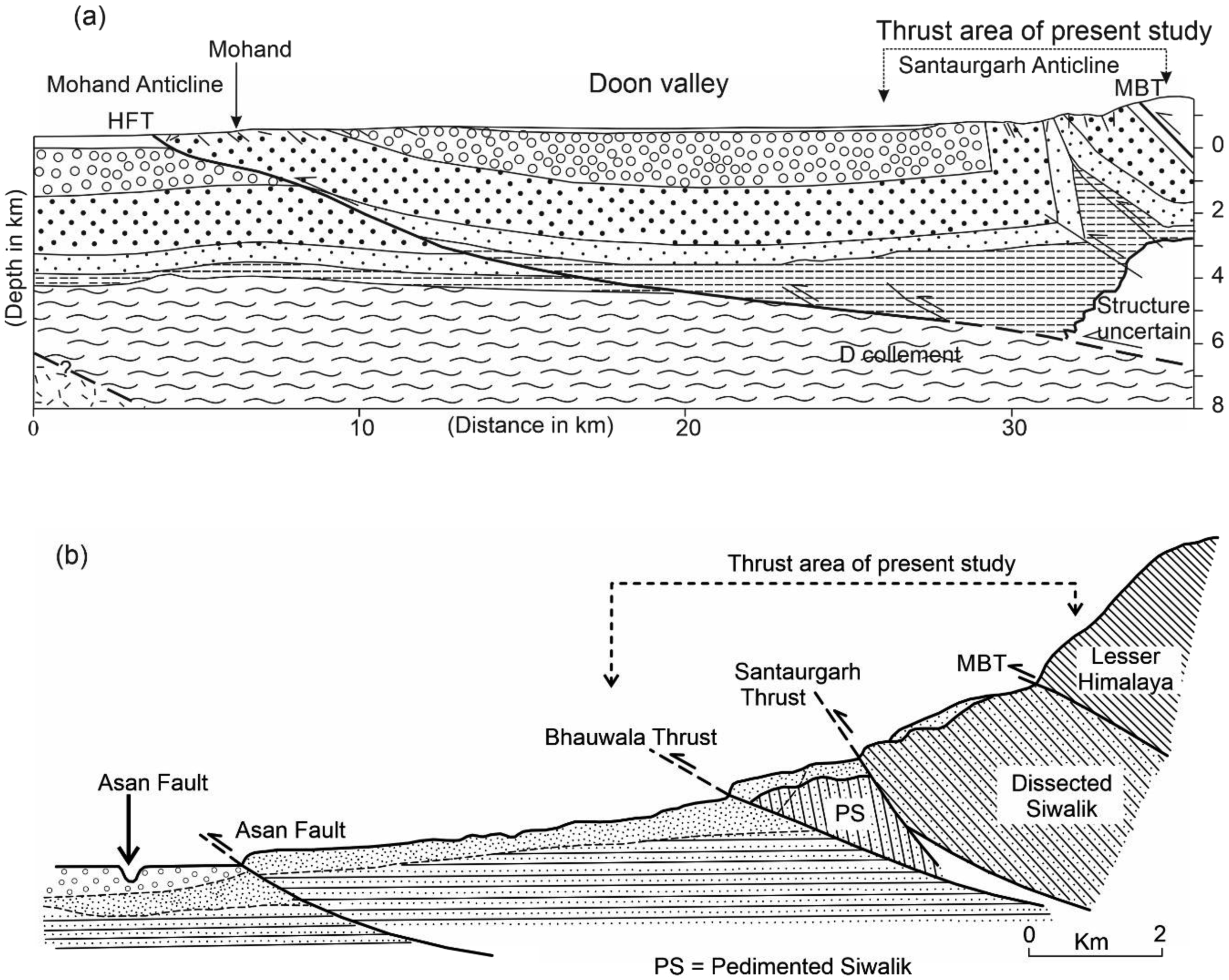

There is a sudden gain in altitude across the MBT and consequently the steep stream gradient has higher SL values that resulted due to uplift of the hanging wall block. Differential erosive power of the tributaries streams and the main trunk, different lithological and structural conditions also resulted in the development of Knick points. The sudden drop of water increases the energy of the streams, causing more bedrock erosion and ultimately influencing the erosional dynamics of the river system (Scheingross et al., 2019; Shawez et al., 2025). As a result, rivers flowing down the steep slopes at the front of the mountains have rapid elevation changes over short distances, creating steeper gradients. Owing to these steeper slope, streams gain more force, causing higher SL index values as they erode the surface and carry sediment more intensely (Troiani et al., 2017).
Normalized steepness index (Ksn), knickpoint, and Chi Integral (χ)
In SB-1, lower values of Ksn and seven knickpoints are observed (Figure 4(a)). Two knickpoints are developed in the footwall of the MBT and observed along the tributaries channel, and the Ksn values are generally <150 with two sections of the stream having >150. Across the MBT, pronounced slope break is observed where the Ksn values are >150 with five knickpoints (Figure 4(a)). The best fit mn ratio for the basin is 0.540 (Figure 4(b)); and the χ plot diverges from linearity and has convexity (zone of uplift) and concavity (zone of erosion) in their longitudinal profile (Figure 4(c)). In SB-2, three knickpoints are developed downstream of the MBT and the Ksn values range from 1.109 to 268.4103 (Figure 4(d)). High Ksn value is associated with the knickpoints formed at the southern tips of the basin. Upstream of the MBT the Ksn values are mostly >150 and four knickpoints are developed three in the main trunk of the stream. The best fit m/n ratio for the basin is 0.5017 with R2 being 0.9542 (Figure 4(e)). The χ plot diverges slightly from linearity marking zone of uplift and zone of erosion in their longitudinal profile (Figure 4(f)). In SB-3, a total of 17 knickpoints are developed, one knickpoint in the footwall portion of the MBT and the rest upstream of the MBT (Figure 4(g)). Downstream of the MBT, the Ksn values are generally <100 with few >150; while in the upstream the main trunk of the stream have Ksn values >200 and tributaries <100 Figure 4(g). The best fit mn ratio for the basin is 0.5086 (Figure 4(h)). Slight deviation from the steady state is observed in the χ plot (Figure 4(i)). In SB-4, all the knickpoints are formed in the hanging wall of the MBT and Ksn values in the footwall of the MBT are <100 with an abrupt rise in the value in a small stretch in the MBT zone (Figure 4(j)). Upstream of the MBT the Ksn values vary from low to the highest value. Clustering of knickpoints is observed. The best fit mn ratio for the basin is 0.6002 the R2 being 0.8735 (Figure 4(k)). Convexity is more dominant as is observed in χ plot (Figure 4(l)). In SB-5, all the knickpoints are formed in the upstream of the MBT and the Ksn values range from 1.0887 to 435.331 (Figure 4(m)). Streams in the footwall of the MBT have Ksn values <150 while in the upstream maximum Ksn values are observed in the mid-section (Figure 4(m)). The best fit mn ratio for the basin is 0.0292 the maximum R2 being 0.8735 (Figure 4(n)). Concavity is more dominant as is observed in the χ plot (Figure 4(o)). In SB-6, knickpoints are concentrated in the mid-section of the basin and seven knickpoints are observed (Figure 4(p)). Ksn values range from 1.3778 to 593.1657 and maximum values are observed in the mid-section of the stream (Figure 4(p)). Maximum values are observed in the main trunk of the stream. The best fit mn ratio for the basin is 0.2002 the maximum R2 being 0.8735 (Figure 4(q)), and the χ plot indicates concavity in the downstream while upstream there is steady state (Figure 4(r)). Knickpoints and Ksn for all the six sub-basins, mn ratio for the sub-basins, and χ plots showing divergence from the linearity. The inset of (f) illustrates convexity in the zone of uplift and concavity in the zone of erosion in their longitudinal profiles.
Field observations
Fluvial morphology
Streams flowing across the MBT particularly between Ganga and Giri rivers have been considered for fluvial morphologies analysis. In this section the MBT, Santaurgarh Thrust, and the Bhauwala Thrust are closely spaced (Figure 1), while Bansiwala Thrust lies further south. In the hanging wall of the MBT the Yamuna River and Tons river valleys are narrow with narrow to vertical valley slope with development of patchy terrace; this suddenly becomes very wide as it enters the Dun.
Shifting of the Yamuna River is observed between Hathiari in the footwall of the MBT to Ponta Sahib, and is represented by paleochannels, different levels of terraces, and scarps. Evidences drawn from the Topographical maps, DEM, and Google Earth Image, Asan, Tons and Yamuna rivers have migrated either way in the recent geological past (Figure 5(a)-(c)). Datta et al. (2024) and Sinha and Sinha (2016) have discussed about the river of migration of Giri, Bata and Yamuna rivers on the basis of fluvial terrace levels and abandoned river channels. The confluence points of Bata River with Giri and Yamuna River have shifted about 5 km SW ward (Datta et al., 2024). In the past as evident from extremely wide paleochannels and levels of terraces, Giri River migrated east ward while at present it is migrating southwest ward. Northwest ward migration of Yamuna River is observed at present in the Dak Pathar area (Figure 5(a)). The migration patterns and subsequent incisions are derived mainly from levels of terraces, paleochannels, and fan deposits. Singh et al., (2001) shows decreasing height of the terrace levels from SE to NW. Asan and Song-Suswa rivers migrated NW and NE ward, respectively, while Tons River migrated NW ward (Figure 5(b) and (c)). At Kalatha, a crescent shaped paleochannel is observed at 1070m asl while the present river bed is at 500m asl (Figure 5(d) and (e)). The width of the water gap or paleochannel measures about 40 m and measures about 0.7 km in length. A few kilometers away at Khadar, another paleochannel is observed of about 2 km in length with a maximum width of about 210 m at 640 m asl (Figure 5(d) and (f)), and is bounded by the MBT in the north and MBF in the south. At the Kalawar-Khadar area, unpaired levels of terraces are developed on the banks of the Tons River, three and two levels of terraces on each bank (Figure 5(i) and (j)). On the right bank three levels of terraces are developed at 541, 530 and 502 m asl while on the left bank at 584 and 530 m asl. In the adjacent Amlava Nadi at Kalsi five levels of terraces are developed on the right bank, 641, 630, 617, 608, and 580m asl, and only two terraces are well developed. Tons River and Amlava Nadi just before exiting into the Dehra Dun have very broad valley in the MBT-MBF zone (Figure 5(g) and (h)). The Tons valley measures approximately 2 km in width at Kalawar, but the valley becomes significantly narrower downstream from the MBF, contracting to under 150 m wide, due to litho-tectonic control. The Footwall of MBF is made up of massive sandstone while the hanging wall comprises of highly sheared Subathu shales. Similar morphology is also developed in the Amlava Valley where in the footwall section the valley width narrows down to about 50 m from about 650 m. A fault trace of about 1.5 km is also developed in the footwall of the MBF (Figure 5(f) and (g)). Asan River flows along the axis of the valley in almost west direction where it confluence with Yamuna River at Asan Barrage. Asan River have migrated northward by about 1.5 km as imaged from Google Earth (Figure 5(b) and (c)). In the eastern part Suswa-Song river also flows in the axis of the Dehradun valley with southwest flow direction, this river also shows northeast migration by about 2.0 km near Doiwala. In the upstream at Raiwala Suswa-Song river have migrated about 1.2 km northeast ward as evident from escarpment that trend NW-SE. The escarpment measures about 25 m in height and is formed in the Bhogpur Fan of Singh et al., (2001). Chandrabhaga Nadi takes a right-angle turn from south flowing to east flowing near Ohni. This stream has incised the fan by about 95m and has a very wide channel of about 700m wide. Semi-radial drainage pattern is observed in the Nagsidh Hill which is an anticlinal structure formed by thrusting along the Nagsidh Thrust (Figure 6(a)). Dulahani Nadi a tributary of Song River is deflected by the Nagsidh Anticline from south flowing to southeast flowing. Incised meandering of Dulahani Nadi is observed in the hanging wall of the Nagsidh Thrust (Figure 6(b)). NW-SE trending erosional escarpment of about 2 km long and 25 m in height (Figure 6(c)) is observed parallel to Dulahani Nadi. Song River and Sahastradhara Nadi flows almost along the NW-SE trending East Kalanga Fault for almost 10 km in length. (a)-(c): Google Earth images showing migration of Yamuna, Tons, and Asan rivers in the Dehradun valley. These river migrations are primarily attributed to the synclinal evolution of the Doon valley where the main deformation is taking place along the HFT. (a). Yamuna River has migrated northwest ward between Kataphar and Dhakrani. (b) Northeast ward migration of Asan River as evident from paleochannels. (c). Tons river migrated northwest ward by about 2.5 km; d-k: Google Earth images and field photographs showing various geomorphology associated with MBT and MBF in Kalsi-Kalawar area. (d), (e) Google Earth images showing paleochannel near Kalatha in the hanging wall of the MBT. (f) Paleochannel, paleolandslide, and fault traces in the MBT-MBF zone, FT - Fault trace along the MBF. (g), (h). Abrupt narrowing down of Tons River and Amlava Nadi in the footwall of the MBF in Kalsi-Kalawar area. (i), (j) Field photographs showing development of wide terraces at Kalawar and Khadar. (k) Field photograph showing the MBF zone where Subathu rock are thrust over the Middle Siwalik. (a) Sketch map of drainage pattern associated with Nagsidh Anticline. (b), (c) Google Earth images showing fluvial landforms associated with Nagsidh thrust and Nagsidh Anticline, incised meandering, escarpment, and deflected stream; Google Earth images showing various fluvial morphologies associated with tectonic activity along the MBT, Santaurgarh Thrust, and the Bhauwala Thrust. (d). Stream migrations, incised valleys, and stream piracies of Nun Nadi and Nimi Nadi with reference to tectonic activity along Bhauwala and Santaurgarh thrusts (PC – Paleochannel, CP capturing point of stream piracy). (e) Tectonically induced fluvial morphology of Sorna Khala, Syaru Khala, and Koti Nadi encompassed by Bhauwala and Santaurgarh thrusts (PC – Paleochannel, CP capturing point of stream piracy). (f) Fluvial morphology of Mauti Nadi, Gauna Nadi, Naro Nadi, Bin Nadi, and Barun Nadi sculptured by MBT, Bhauwala and Santaurgarh thrusts (PC – Paleochannel, CP capturing point of stream piracy).

Stream/river piracy
A number of wind gaps are observed in the satellite imageries, topographic maps and Google Earth images between Dehradun and Tons River. At Santaurgarh, Nun Nadi has migrated about 1.5 km eastward (Figure 6(d)). The width of the paleochannel measures 1.2 km, where the eastern portion has been incised by the stream, and the width of the valley floor measures about 130 m. The stream migrated eastward gradually and a number of paleochannels were developed. Within the wind gap, new smaller channels have developed, which may result in capturing of the stream and realignment of the new channel. At one stage of the stream migration of Nun Nadi and Nimi Nadi, they confluenced at Anwaliwala-Sailan area. Nimi Nadi, then, started migrating eastward followed by the migration of Nun Nadi (Figure 6(d)). Nimi Nadi have migrated eastward by 2.2 km from its former channel. The paleochannel of Nun Nadi at present time is incised by Nimi Nadi and its small tributary. Bhidoli area represents the paleochannel of Sorna Khala. Sorna Khala migrated westward and Dunga area represents the paleochannel (Figure 6(e)). Syaru Khala has shifted eastward over time and currently merges with Sorna Khala at a location approximately 3.5 km downstream from where it previously confluenced (Figure 6(e)). Koti Nadi migrated westward in phase wise though not all the paleochannels have been preserved, but three very prominent paleochannels are developed having widths 430 m, 202 m, and 185 m, respectively from east to west. Erosional scarps in the form of scoops are preserved supporting the paleochannels that measures about 10 m in height. Extremely wide paleochannel of Sorna Nadi is exposed at Barwa-Tikri area where the paleochannel is 1200 m in width. Few meters below two distinct paleochannels are developed with a width of 985 m and 650 m, respectively from northwest to southeast. The confluence point of Gauna Nadi and Mauti Nadi was at Langha, while at present the confluence is at Dabthala which is about 5.5 km southwest of Langha (Figure 6(f)). Landforms suggest that Gauna Nadi, Naro Nadi, and Bin Nadi represent different stages of stream migration and stream piracy. Initially Gauna Nadi was flowing through the Pasta, Langha, Tauli, and confluenced with Yamuna River at Katpathar. In the later phase the flow direction changes to Pasta, Langha, Dungakhet, and Dabthala (Figure 6(f)). The maximum width of paleochannel presently occupied by Naro Nadi is at Tauli where the width is about 960 m while at Langha the width is about 650 m. Along Gauni Nadi the maximum width is about 685 m. The present Bin Nadi channel is very narrow with two fans deposits observed at 922 m asl and 859m asl, respectively near Malwara and the present river bed is at 791m asl (Figure 6(f)). Northwest of Bin Nadi is the Barun Nadi, this stream has also incised the both the fan and bedrock and is characterized by very narrow valley. Fan deposits are observed in patches; both the bedrock and fan deposits have been incised by the stream. Bin Nadi, Barun Nadi, Naro Nadi, and its small tributary streams are deflected northwest ward between the MBT and Bhauwala Thrust in Hathiari-Kata Pathar area in the exit area of Yamuna River into the Dehradun Valley (Figure 6(f)).
Tectonic geomorphology
At Binhar in Mandarsu-Chamela-Kol area about 1.5 km long three almost parallel fault traces 200 m apart are observed at the ridge crest in the Google Earth image (Figure 7(a)). Extensional tectonics related open fractures are observed in alternation of phyllite and siltstone (Figure 7(b)). Traces of other faults are also observed but they are poorly preserved and are placed southward of the two fault traces (Figure 7(a) and (c)). The fault scarps dip toward the south, and triangular facets are observed (Figure 7(a), (c)–(e)). The width of the fault zone measures about 560 m and the fault traces trends SE to NW. In the out crop the fault zone are represented by highly sheared limestone, with thinly bedded slates and phyllite. The fault zones are measured to be more than 10 m in width and are best exposed along the road sections (Figure 7(f)). Amongst the fault traces the middle fault trace is the most prominent, and sag ponds are formed along the fault traces (Figure 7(c) and (d)). Along two of the fault traces, equal number of sag ponds of four each is developed. The ridge crest is relatively gentler than its surrounding ridge crest due to movement along the faults. The present topography suggests that the northern most fault trace has been much modified by the headward erosion of the north flowing streams. In the western extremity the two northern most fault traces merges into a single fault near Mandarsu. The largest sag pond is observed at Mandarsu, where a remnant of sag pond is observed. Linear depressions along the fault traces are one of the main tectonic landforms associated with the MBT and its fault splays. Normal faults are observed in thinly bedded bedrock. Linear depression characterized the trace of MBT in Bhitarli area that has become less distinct due to erosion with the passage of time. Triangular facets and fault scarps have also been degraded by erosions. Highly sheared Siwalik bedrocks are observed in the footwall of the MBT that dips steeply. Further west of Bhitarli at Thangaon linear depression measuring about 1.5 km is observed in the immediate hanging wall of the MBT. Here the hanging wall rock is made up of highly fractured quartzite and phyllite. The quartzite bedrock dips almost horizontal to gently dipping (Figure 7(h)). Brittle shear sense can be observed in the bedrock, while the overlying phyllite dips moderately (28° - 35°) towards northeast. The footwall is made up of steeply dipping to almost vertical conglomeratic boulders of the Upper Siwalik (Figure 7(i)). The boulders of the conglomeratic bed are highly sheared and individual boulders are marked by displacement along the faults (Figure 7(g)). The shear zones discernible within the boulders measures about 6 cm in width, while displacement measures from mm to 1 or 2 cm length. Trace of the MBT is depicted by slightly curved depression between Pasta and Koti that have degenerated by the action of landslides and erosion. At Pasta the conglomerate clasts of the Upper Siwalik constituting the footwall of the MBT are highly sheared and fractured, where a thick fault zone represented by fault gouge is seen along the road section. The highly sheared conglomerates are underlain by sandstone of the Middle Siwalik (Figure 7(k)-(m)). (a), (c) Google Earth Images showing fault traces and sag ponds formed at the Hanging wall block of the MBT at Binhar. (b) Open fractures formed in competency contrast layers due to extension tectonics in the hanging wall block of the fault traces. (d), (e) Field photographs of fault scarps and sag pond, the fault scarps are south dipping. (f), (g) Fault zones are defined by development slickensides and open fractures indicating sense of movement, bedrock is siltstone and limestone. (h) Highly fractured quartzite with sense of movement similar to the MBT at the base of MBT at Thangaon. (i). Vertically bedded conglomerate of the Upper Siwalik. (j). Highly sheared Upper Siwalik cobbles with sense of shear at the top of the footwall of the MBT. (k). MBT section at Pasta the bedrock is covered by thick colluvial deposit, sudden gain in slope gradient is observed in the hanging wall of the MBT. (l). Fault zone represented by fault gouge and sheared conglomerates, shear sense indicated by gently dipping fault plane. (m) Highly sheared pebbles of Upper Siwalik with sense of shear at the top of the footwall of the MBT.
The MBT and MBF in the Ton River valley are only 1.5 km apart and the intervening valley is very wide. The bedrock in the MBT zone is highly sheared and fractured where the footwall is made up of marron colored shale of the Subathu Formation. The narrow valley in the hanging wall of the MBT is about 65 m wide of steep slopes with multiple landslides, while in the immediate footwall the valley width becomes about 1.7 km. In the MBT the Lesser Himalayan and sub-Himalayan rocks are clearly discernible by their color contrast. The MBT here is low dipping as indicated by almost horizontal bedding of the hanging wall and footwall rocks. The wide valley suddenly narrows down in the footwall of the MBF to about 100 m from 1.7 km wide. In the Khadar area the MBF is represented by a fault trace that measures about 1.5 km long depression, with scarp dipping towards north (Figure 5(f) and (g)). The footwall is made of massive Middle Siwalik rocks that dip 20 towards northwest. The wide intervening valley between the MBT and the MBF is characterized by strath and fill terraces (Figure 5(f)-(j)). Strath terrace is also observed at the top of the footwall of the MBF, where gently dipping Middle Siwalik sandstone is overlain by fluvial sediments.
Fans and landslides
The width of the sub-Himalaya ranges from 0 to 80 km along the entire length from east to west (Karunakaran, 1976; Luirei et al., 2014; Powers et al., 1998; Raiverman, 2002). Apart from this section the entire stretch of the sub-Himalaya is either broad or narrow. In the northwestern Himalaya, During the Quaternary period the re-entrant structure of Dehradun characterized by wide synclinal valley has been filled by alluvial and fan sediments. The hanging wall block of the MBT is more susceptible to landslides and severe erosion due to highly sheared and crushed bedrock with steep topography than the low lying footwall block which are sedimented. The hanging wall rocks are more prone to landslide than the footwall rocks due to highly fractured nature of the bedrock and steeper slopes (Figure 8(a) and (b)). In the MBT zone at Hathiari, the gently sloping slopes in the Siwalik are overlain by fan deposits of varying thickness. At Thangaon the Upper Siwalik rocks are overlain by huge thickness of fan sediments. Multiple levels are developed in the higher elevations while fluvial terraces occupy lower elevations (Figure 8(c) and (d)). Singh et al. (2001) classified the fans in Dehradun valley into Donga Fan, Dehradun Fan and Bhogpur Fan, of which in the Donga and Dehradun fans the sediments indicates different energy conditions and environment; the proximal part dominated by sediments deposited by small streams by sediment gravity - flow deposits while middle part characterized by mostly mud flow deposits and minor braided streams (Singh et al., 2001). Deposition by larger braided stream is envisaged for the formation of the Bhogpur Fan (Singh et al., 2001). Along the Hatnala in the hanging wall block of the MBT a stretch of about 105 m long fan deposit is exposed as a result of incision by the stream. More than 2 m thick fan sediment is exposed which is composed of tilted laminated sediments overlain by unstratified fan deposits. The sediment section resembles numerous intruded dyke sediments. Here the dykes like sediment bodies still maintain the stratification while the top overlying sediments lacks stratifications (Figure 8(e)-(h)). The undeformed layers are lighter in colors where are the deformed layers are muddy in color illustrating two different deposits. At Thangaon the Lesser Himalayan rocks rides over highly sheared conglomerates (Figure 7(i) and (j)). The bedrock in the hanging of the MBT is made up of highly fractured gently dipping quartzite, while the footwall is made up of steeply to almost vertical beds of Upper Siwalik conglomerate. The landslide occurring in the hanging wall of MBT near Koti is active prior to 1985 as imaged from the Google Earth Image, while the landslide in the upstream of Koti Nadi initiated around 2016 (Figure 8(a) and (b)). (a), (b) Google Earth images showing landslides in the MBT of Koti between 2016 and 2025. (c)-(d) Uplifted fan deposits at Thangaon in the immediate footwall of the MBT the exposed section comprising of Upper Siwalik bedrock and overlying fan deposits measures about 195 m in height. (e)-(h). Neptune dykes observed in the Quaternary deposits, dyke like features made up of undeformed laminated sediments while the layers which have been intruded are deformed.
The hanging wall of the MBT between Tons and Song Rivers is defined by number of old as well as active landslides. Tectonic, geomorphological, climatic, and anthropogenic factors are the main reason for the instability of the south facing slopes of the Mussoorie hills. Tectonic factor is the most important factor amongst all the factors as the bedrock is traversed by number of joints and faults. Hanging wall slope have been affected much more severely than the footwall slope as the footwall rocks have suffered less shearing and shattering in comparison with the hanging wall rocks. The width of fault gouge and fault breccias in the footwall is much less than those in hanging wall rocks. The continued deformations along the MBT and its splay thrusts have resulted in the development of number of joint sets, and the intersecting joints have formed wedges. The closely spaced open fractures and joints, bedding planes along with the wedges have initiated most of the landslides. In the limestone and shale closely spaced open fractures that are perpendicular to the bedding planes are developed resulting in complex slope movements. In the phyllite constituting the bottom of the MBT fault plane the bedrock are highly sheared in the form of fault gouge, and numbers of normal faults are also observed. Sliding type of movement is the main type of movement observed in phyllite and slates. The highly crushed zones are site of many landslides. The quartzite bedrock is traversed by numbers of joints and faults. The intersecting joints forms wedges towards the open slopes and wedge failure are very common in the quartzite.
Discussion
Landscape evolution is occurring over a range of time spans uplift in the initial stage followed by much longer tectonic quiescence and erosion (Keller and Pinter, 2002). In the evolution of Dehradun valley, providing the space for accommodation of the sediments in the valley was influenced by tectonic activities, while aggradation and incision of the fans were controlled by climatic disturbances (Sinha and Sinha, 2016). In the initial stage of evolution of the Dehradun intermontane valley the MBT was the active mountain front but subsequently the tectonic activity shifted towards the south and at present HFT is the active front, and now the MBT is the intermontane mountain front (relic). Although HFT is the active mountain front at present numbers of morphometric features attributing to the recent activities along the MBT is also reported (Thakur and Pandey, 2004; Riesner et al., 2021; Yeats and Thakur, 2008). The most prominent is the fault trace with north dipping fault scarps which is clearly discernible in satellite images. Fault traces along the MBT are also reported from Gaula River where faulting has truncated a fan deposit resulting in the formation of fault scarps, sag ponds, wind gap, and deflection of streams (Kothyari et al., 2010, 2012; Luirei et al., 2014; Valdiya, 1992). Similar observations are also reported from the Central Himalaya that extends from Kali River in the west to the Sapt Kosi River in the east (Luirei et al., 2024; Nakata, 1972). Fault depressions, sag ponds, linear ridges, pressure ridges, stream deflection, and dislocated alluvial fans are other morphotectonic features associated with the MBT. Similar observations of river deflection along the MBT have been reported from other parts of the Himalaya (Datta et al., 2024; Gupta, 1997; Luirei et al., 2021, 2023). Evidence of localized extension tectonics in the hanging wall of the MBT is observed in the form of fault scarps and sag ponds, the displacement took place along the bedding plane as evident by slickensides and small scale normal faults indicating sense of movement. Fault scarps generated by normal faults are also reported from different segment of the Himalaya (Bhakuni and Luirei, 2016; Luirei et al., 2016; Mehta and Sanwal, 2011; Mugnier et al., 1994; Nakata, 1989; Riesner et al., 2021). Rautela and Sati (1996) also identified three distinct neotectonically active domains on the basis of field evidences in the Dehradun valley which are classified as (1) Normal faulting are taking place in the northern flank of the Siwalik belt, (2) central zone characterized by south directed thrusting, and (3) the southern belt with prominent back thrusting. Similar observation is also observed in the Kadhar-Kalsi area where curvilinear fault trace is developed along the MBF.
The geometry of fluvial system is often influenced by the rock structure and/or ongoing tectonic activity, where the influence is shown by drainage pattern and stream pattern (Keller and Pinter, 1996). Adjustment of the drainage or stream to the ongoing tectonic activity in the present study is documented from deflected streams, incised valley, stream piracy, and paleochannels. In the case of paleochannel at Khadar-Kalsi area it developed because of massive landslide that block the channel of Amlava Nadi and also headward erosion by small stream (Figure 5(d)-(f)). In the MBT zone Barun Nadi and Bin Nadi its tributaries show structural control with preferred deflection towards the west. The development of drainage pattern particularly of Bin Nadi, Naro Nadi, Gauna Nadi, and Surna Nadi (Mauti Nadi) is very complex as indicated by wide paleochannels and deep incised valleys. At Pasta thick fan deposit over highly sheared Upper Siwalik rocks are observed prior to the stream piracy by Bin Nadi the Naro Nadi was flowing across the MBT from the catchment in the hanging wall. Pasta village is nestled over old paleochannel of Gauna Nadi and at present is a water gap. Two very wide channels are observed at Langha one flowing towards northwest and other flowing southwest ward, both the channels has been incised by small streams. From the paleochannel reconstruction, it is observed that the wide channels were drained by large water bodies which at present are a misfit. Before capturing of the stream channel of Naro Nadi by Gauna Nadi, Naro Nadi was flowing almost southwest ward and turns northwest ward from Langha. Southward migration of Naro Nadi is evident at Paprian, structural control on flow pattern of small tributaries of Naro Nadi is observed where the streams have migrated westward in uniform manner between Langha and Paprian. Mauti Nadi and Gauna Nadi confluence near Langha, Mauti Nadi and its tributary was flowing southwest ward before being captured by the small stream that was flowing in present day of Mauti Nadi, the paleochannel being observed as large water gap. Along the Channel of Koti Nadi water gap is developed Kotra, along the channels of Koti Nadi and Saurna Nadi both the streams have incised the fan by more than 70m, at some point more than 100m deep. Syaru Khala and Saurna Nadi were flowing southward without confluencing, Syaru Khala captured Saurna Nadi near Dunga. Dunga is settled at the water gap of Sauna Nadi, where the width of the water gap is about 0.67 km wide, and Sauna Nadi has incised the Dunga Fan by about 125m deep. Syaru Khala migration is also supported by the decreasing height of the terraces almost westward, where six levels of terraces are developed (Singh et al., 2001). Stream piracy is also observed at Bidholi where the paleochannel of Nimi Nadi is exposed as water gap. Nun Nadi have deflected eastward due to stream piracy by a smaller stream, the water gap is again being incised by small streams. Thakur et al. (2007) are of the view that the growth of Santaurgarh Anticline predates the growth of Mohand Anticline and the Siwalik Range, confirming to the present observation that the MBT is the relic mountain front. The gradual growth of the Santaurgarh Anticline resulted in incision of the dissected Siwalik and deflection of the streams. In the later phase of uplift along Santaurgarh Thrust, Bhauwala Fault, and Majhuan Fault contributed to the development of various water gaps, stream piracy, deflection of streams, and incision of the fan deposits. Headward erosion by small streams also resulted in the development of water gaps and stream piracy. The linearly arranged curved stream channels of the tributaries of Bin Nadi are related to the growth of Santaurgarh Anticline, as all the streams have straight first order channel but got deflected near the confluence with Bin Nadi. The migration of Asan Nadi and Suswa-Song Nadi towards northwest ward and northeast ward is assumed to have resulted due to tilt induced migration as consequence to the growth of the Mohand Anticline. The decreasing level of terraces of Yamuna River in Vikasnagar (Singh et al., 2001) indicates migration of the river in northwest direction by about 3 km northwest. In the Nagsidh Hill radial pattern of drainage is developed. In general radial patterns are formed around structural high points such as volcanoes, salt domes, or tectonic upwarps (Keller and Pinter, 2002). In the case of Nagsidh Hill the radial pattern developed due to thrusting along the Nagsidh thrust resulting in producing anticlinal structure named as the Nagsidh Anticline (Raiverman et al., 1983; Rautela and Sati, 1996). Along with the radial drainage pattern deflection of Dulahani Nadi is also observed that resulted from the growing Nagsidh Anticline (Figure 6(a)-(c)). Luirei et al. (2015) described rivers migration in the mountain front that resulted from uplift along the Himalayan Frontal Thrust. Between 30 ka and 10 ka there was extensive lateral erosion (Singh et al., 2001) when the tectonic activity was subdued, which must be the reason for the very wide channels. These channels remain as water gaps at present which have been incised due to later phase of uplift and stream piracy.
Morphometric analysis of various terrains confirms the usefulness of indices of active tectonics to help understand active fold growth (Bull, 1977, 1978; Cox RT, 1994; Demoulin, 1998; Hack, 1973; Keller, 1986; Rhea, 1993; Strahler, 1952). In the present study SL, Ksn, and Chi Integral have been analyzed with reference to MBT and its splay thrusts. Topographically there is a sudden gain in height across the MBT and this is also reflected in SL index and longitudinal profiles along all the analyzed sub-basins. The SL index of stream of SB-1 shows SL peaks developed south of the MBT, and the five peaks are closely spaced, and this may correspond to the MBT and the four parallelly arranged faults between the MBT and Santaugarh Anticline mapped by Rautela and Sati (1996). Along the stream of SB-2, SL peak at MBT is not prominent while the highest peak is developed in the hanging wall of the MBT, and this corresponds to the lithological variation. The SL peaks of stream of SB-3 are spaced between 4 km and 7.5 km downstream and this corresponds to the four parallelly arranged faults, Santaurgarh Thrust, Majhuan Fault, and the Bhauwala Thrust. The SL peaks of stream of SB-4 is feeble at the MBT zone, while prominent peaks of importance are observed south of the MBT and may corresponds to the structures described for stream P3. SL peaks for streams of SB-5 and SB-6 are subdued in the fault zones, while there are prominent peaks along the streams at 3.5 km from the source and may indicate either lithological variation and/or slope gradient. This is also reflected in the Ksn values of the two streams of SB-5 and SB-6 where abrupt rise in Ksn values are observed. Two segments of the main trunk of stream of Basin 1 shows relatively higher value of Ksn in the footwall portion of the MBT, and correspond with the SL peaks of stream of SB-1. In all the basins analyzed for knickpoints it is observed that most of the knickpoints are concentrated upstream of the MBT which resulted from upstream propagation of the knickpoints due to uplift along the MBT and erosion. The knickpoints in the tributaries are indication of differential rate of incision between the main trunk and its tributaries, where knickpoints along the main trunk are more significant. Studies carried out in northeastern Brazil suggest widespread formation and upstream propagation of knickpoints resulted from the response of bedrock rivers to a sudden drop in base level (Panta et al., 2025). In the eastern Himalaya knickpoint migration has resulted in significant differential uplift and bedrock erosion and as such the mean relief and minimum eroded rock column of the catchment have expanded (Kashyap et al., 2024). Similar observations are also observed in χ plots which indicate uplift in the upstream while erosion in the MBT zone and downstream. The results of knickpoints and χ plots correlates with the findings of Singh et al. (2001) where the pedimented Siwalik Hills between the major fans (Dunga and Dehradun) were defined by low rate of uplift and stream erosion or incision rate matches the rate of tectonic uplift. Portion between the MBT and the Santaurgarh Anticline is characterized by erosion and the streams have incised into the Siwalik Hills as indicated narrow valleys with steep valley walls.
In the Dehradun valley the south facing slope of the Mussoorie Hills is defined by very steep slope with abundant landslides (Figure 8(a) and (b)). The streams have very high gradient and have high erosive power particularly in the upstream of the MBT. The enormous amount of sediments accumulated in the Dehradun valley is due to highly crushed and sheared rocks with steep slopes that give way easily to erosion and landslides, and at present is represented by the landslides taking place near Koti, generating an enormous amount of sediments (Figure 8(a) and (b)). The MBT and its imbricate thrusts reactivated during 50 ka that resulted in strong relief and deposition of the major fans (Singh et al., 2001; Singhvi et al., 1994). Apart from geomorphological evidences of tectonic activity, highly fractured and sheared pebbles of the Upper Siwalik rocks in the footwall of the MBT are observed (Figure 7(j) and (m)). At Thangaon, the boulders of the conglomeratic bed dips steeply and are highly sheared and individual boulders show sense of deformation as they are faulted. The shear zones discernible within the boulders measures about 6 cm in width, while displacement measures from mm to 1 or 2 cm length. At Pasta similar observation are also made, here a zone of highly crushed and sheared boulders are observed. A gently dipping fault plane (15° towards NNE) is observed, below which a thick zone of fault gouge is observed measuring more than 5 m in thickness (Figure 7(l)). Rautela and Sati (1996) reported shear zone near Koti, where the conglomerate pebbles are shattered and differentially displaced. Similar finding were also reported from Koti area by Thakur et al. (2007) where the footwall of the MBT the Siwalik strata show the development of complementary shear zones, with top-to-south shearing. Present and previous studies indicate the brittle and intense deformation along the MBT of very recent past. Fluvial geomorphology, morphotectonic features, and deformed Quaternary sediments are suggestive of the role of tectonic activities in architecting the landforms of the Dehradun valley. To give a clear picture of the conceived idea for the evolution of landforms in the present study area, a model has been proposed and is depicted in stages as illustrated in Figure 9 and this illustration represents the theme of the study. Evolution of the landscape in the present study has been illustrated by diagrammatic representations and are not in scales. (a). In the initial stage of landscape evolution, the Main Boundary Thrust was the active mountain front where at later stage the deformation thrust front shifted south and is defined by the splay thrust. The Lesser Himalaya acted as zone of erosion while the synclinal section represented by the Doon valley acted as the zone of deposition. (b). In the second stage of evolution due to continued tectonic deformation coupled with climatic factor channel widening and steady deflection of streams occurred with extremely wide stream channels. The main deformation migrated further south forming new thrust front as exemplified by fault scarps and incision by streams. (c). This stage depicts the present scenario where stream deflection in MBT is observed with formation of antithetic slopes. The once wide channels are observed as paleochannels, and in it small streams have deeply incised the sediments and the bedrock. (d). This section represents the mid-section marked in (c) of the valley, it suggests evolution of terraces and strath which resulted from migration of the streams and down cutting by the streams due to uplift along the splay thrust. In the field, these types of landforms are developed between MBT and Bhauwala Thrust (Figure 1), and such landforms are shown in figures 6(d)-(f), 7(h)-(m), and 8.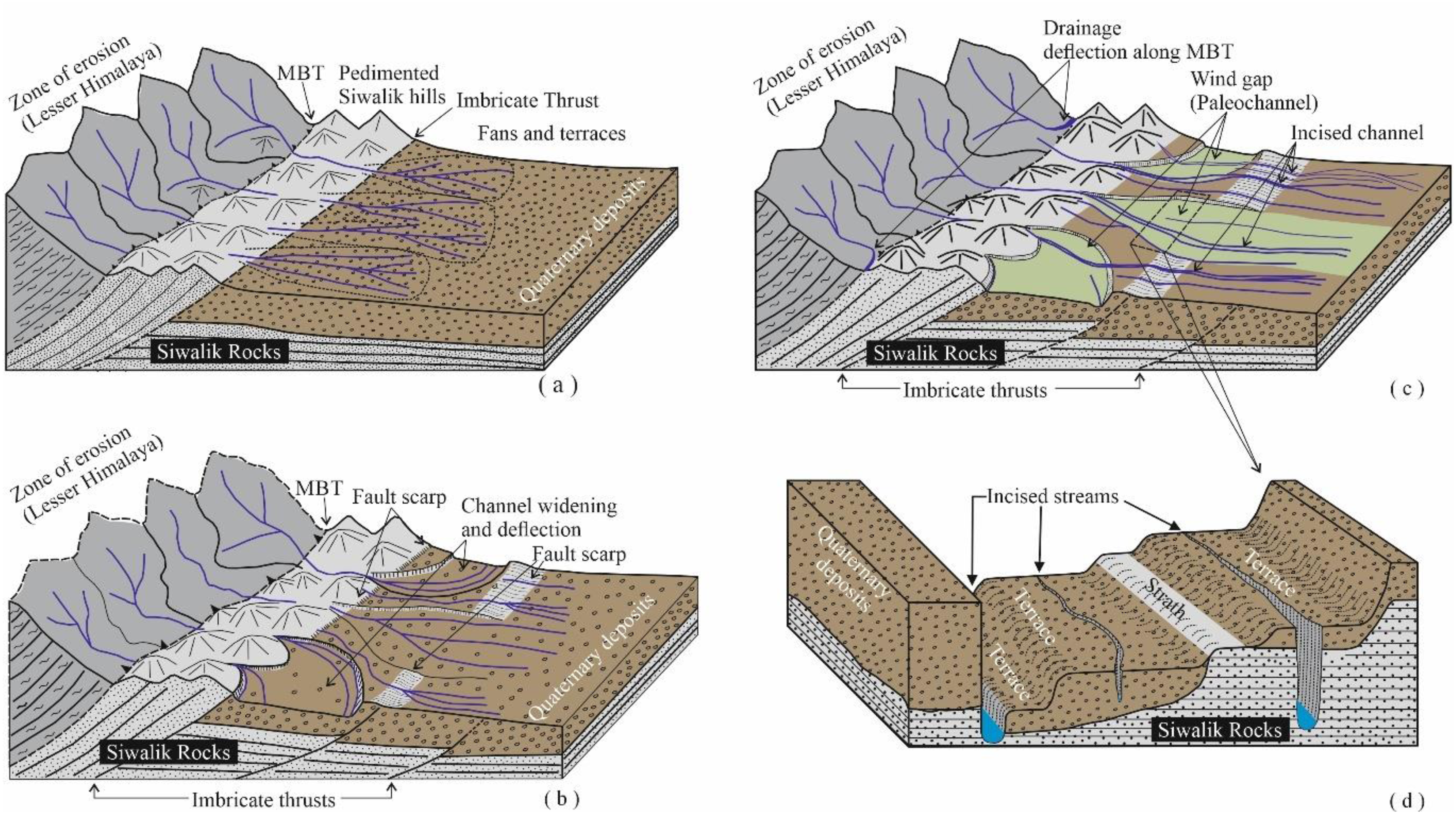
Conclusions
(1) Fluvial features such as stream migration and piracy, paleochannels, incised valleys, are associated with neotectonic activities along the Bhuawala and Santaurgarh Thrusts. The geomorphological evolution modal is illustrated through the model (Figure 9). (2) Abrupt river narrowing and fault scarps along the MBF, linear river valleys, drainage deflection, and sheared boulders within the MBT zone suggest recent tectonic activity. (3) Radial drainage pattern on Nagsidh Hill and associated features like escarpments and incised meanders suggest thrusting along the Nagsidh Thrust. Similarly, the migration of Yamuna, Asan, and Song-Suswa rivers in the axial part of the Dehradun Synclinal valley reflects the influence of the growing Mohand Anticline. (4) Morphometric indices (SL, Ksn, Chi) support field observations, indicating ongoing tectonic uplift in the hanging wall of the MBT. Parallel fault traces and sag pond in the hanging wall block of the MBT reflect a complex interplay of compressional and minor extensional regimes. (5) Present findings address the adjustment of the fluvial system with the ongoing tectonic activity, and substantiate the structural and climatic models put forward by earlier workers.
Footnotes
Acknowledgments
The authors are grateful to the Director, Wadia Institute of Himalayan Geology, Dehradun for providing the necessary facilities and kind permission to carry out the fieldwork and publish the work (WIHG/0394). AD (Emp ID. 135032) is grateful to Geological Survey of India, GSITI, Hyderabad for providing the kind permission to carry out this work as part of his PhD work. MS is grateful to Council of Scientific and Innovative Research for providing fellowship (file number- 09/0420(15968)/2022-EMRI). AKG is also grateful to University Grant Commission for providing fellowship (NTA Ref. No. 200510505733). Parts of the data are from the PhD work of AD.
Author contributions
Khayingshing Luirei: Writing—original draft, Methodology, Investigation, Conceptualization. P.K.R. Gautam: Writing and editing. Anand Kumar Gupta: Morphometric analysis and writing. Mohd Shawez: Morphometric analysis and writing. Anirudh Datta: Morphometric analysis and writing. Manish Mehta: Writing, review and editing. Naveen Chandra: Writing and editing. Rouf Ahmad Shah: Writing and editing.
Funding
The authors received no financial support for the research, authorship, and/or publication of this article.
Declaration of conflicting interests
The authors declared no potential conflicts of interest with respect to the research, authorship, and/or publication of this article.