
Abstract
Armed conflict accelerates soil and vegetation degradation, but field assessments and monitoring are often only possible at a later stage and/or indirectly, for example, through remote sensing data. We used the Dynamic World v1, a land-cover open-source dataset derived from Sentinel-2 imagery, to quantify land-cover change in Gaza (Palestinian territories) between September 2023 and September 2025. After cloud/shadow masking and 10 m spatial estimation, cropland and grassland declined from 5941 to 2056 ha (−65%), while bare soil expanded from 3918 to 17,663 ha (+351%). A comparator region in Israel showed modest changes (−4.5% and +3.4%, respectively), indicating that the Gaza trends are conflict-related rather than regional. High-resolution imagery reveals widespread transition from vegetated surfaces to debris fields and exposed soils. Our findings corroborate recent analyses based on commercial imagery while extending the assessment to 2025 through a fully open-source workflow. We present a fully reproducible workflow in Google Earth Engine to document and quantify land degradation using open Earth observation data under conditions of restricted ground access. These results provide a quantitative baseline for assessing soil and vegetation damage in conflict-affected areas.
Introduction
Soil is a multifunctional, non-renewable resource that supports plant growth and ecosystem services and is essential to human well-being and quality of life (FAO & ITPS, 2015). Yet, it is continuously under pressure from degradation processes driven by multiple factors, primarily anthropogenic, including compaction, chemical contamination, loss of organic matter, erosion, salinisation, acidification, loss of micro- and macro-biodiversity, and nutrient depletion (Saccá et al., 2017). These threats directly impair the capacity of soils to support healthy and diverse plant communities and are further exacerbated by climate change (Lal, 2012). Beyond these pressures, armed conflict has been identified as a significant contributor to multiple drivers of soil degradation (Certini and Scalenghe, 2023; UNEP, 2024; Zhang et al., 2023). Building on the United Nations Environment Programme report (UNEP, 2024), which identified multiple environmental impacts in Gaza (Palestinian territories), including effects on terrestrial environments, here we focus on soil and vegetation degradation. While these degradation processes predate October 2023, the recent conflict has dramatically exacerbated them (e.g. Hassoun et al., 2025). This study does not attempt to reconstruct the full multi-decadal history of land degradation in Gaza, but rather quantifies the severe impact observed between 2023 and 2025. In this context, remote sensing provides a robust and timely means to quantify soil and vegetation damage during armed conflict, when access constraints severely limit field-based observations. Since October 2023, Gaza has been subjected primarily, though not exclusively, to aerial bombardment and associated ground operations, with major consequences for land degradation. These impacts are associated with high contaminant levels of heavy metals, hydrocarbons, and other chemicals, as well as vast amounts of debris from destroyed buildings and unexploded ordnance. It has been estimated that around 39 million tons of debris have been generated, corresponding to over 107 kg m−2 on Gaza’s land surface (UNEP, 2024). This figure is likely an underestimation and does not account for the subsequent impacts since that estimate was made (UNEP, 2024). Contaminants can persist in the environment for extended periods, be remobilised, transferred, and/or (bio)accumulated, ultimately posing serious health risks to animals, humans, and plant communities (Gorsevski et al., 2012). Furthermore, armed conflict-related degradation factors include soil compaction caused by heavy military vehicles, vegetation removal, cratering from bombings, and intensified salinisation due to the destruction of water infrastructure (Broomandi et al., 2020; Zhang et al., 2023). Vegetation loss and bare-surface expansion during conflict can also result from non-bombing mechanisms, such as mechanical clearing (e.g. bulldozing fields and orchards, such as olive groves in Gaza), land grading, road widening, and the creation or expansion of ‘buffer zones’ (Meaza et al., 2024). Also, herbicide and defoliant use near borders, adopted as a military tactic designed to destroy enemy cover, food supplies, and infrastructure (Westing, 1972), may cause sudden and intensive vegetation decline.
Nevertheless, none of these degradation drivers could be assessed directly in the field, because independent ground access to Gaza was not possible during the study period. Thus, remote sensing emerges not just as a complementary method but as the most practical approach for assessing vegetation and soil change in areas under conflict, such as Gaza (Gorsevski et al., 2012; Yin et al., 2025; Zhang et al., 2023). Here, we aim to provide a quantitative, spatially explicit assessment of the recent exacerbation of vegetation and soil degradation in Gaza resulting from the 2023–2025 conflict, using fully open-source, reproducible remote sensing data and methods.
Material and methods
We quantified vegetation dynamics using Sentinel-2 L2A (SR Harmonised) together with Dynamic World v1 (Brown et al., 2022). Unlike Yin et al. (2025), who used commercial PlanetScope and SkySat imagery until September 2024 with expert-trained machine-learning approaches, our workflow relies entirely on open Sentinel-2 and Dynamic World products through until September 2025, extending the timeline and prioritising interoperability, reproducibility and transferability. Two areas of interest were analysed: the Gaza Strip, as a conflict-affected region, and Israel, used solely as a neighbouring area with broadly similar climatic conditions during the study period to distinguish conflict-driven change from regional environmental trends (Figure 1). Illustrative zoom from northern Gaza (Jabalia–Wahsh). Top: Sentinel-2 true-colour (B4–B3–B2) from 7 Sep 2023 (left) and 11 Sep 2025 (right). Bottom: corresponding false-colour (B8–B4–B3) composites, where red denotes vegetation. The Gaza border (yellow line) is overlaid. Red tones in the false-colour image are extensive in 2023 but markedly reduced in 2025, indicating widespread vegetation loss and the expansion of bare surfaces – especially within the border, with clear visual contrasts between bare soil and crop cover compared with adjacent areas outside. For interpretation of the references to colours in this figure legend, refer to the online version of this article
In Google Earth Engine (GEE), we selected the most cloud-free Sentinel-2 image in September 2023 (7 Sept 2023) and 2025 (11 Sept 2025), masking clouds, cirrus, and shadows using the S2 SCL band. For each Sentinel-2 date, we paired the closest Dynamic World ‘label’ within ±7 days (fallback to the September mode when no close acquisition was available). Areas (in ha) were computed at 10 m via pixelArea () and summed for grass (2), crops (4) and bare soil (7), enabling the reporting of cropland, grassland and bare soil (Figure 1).
Results and discussion
Between September 2023 and September 2025, cropland and grassland in Gaza declined sharply from 5941 to 2056 ha (−3885 ha; −65%; Figure 2), while bare soil expanded dramatically from 3918 to 17,663 ha (+13,745 ha; +351%). The corresponding Sentinel-2 images (Figure 1) clearly show vast areas that transitioned to bare surfaces, consistent with debris fields and exposed soils following bombardment and ground operations. Changes in land cover between September 2023 and September 2025 in the Gaza Strip and Israel. Top: cropland and grassland areas declined sharply in Gaza (−65%), but only slightly in Israel (−4.5%). Bottom: bare soil expanded dramatically in Gaza (+351%) while showing only a minor increase in Israel (+3.4%). These contrasting trends highlight the extensive vegetation loss and soil exposure within Gaza following the conflict, compared to relatively stable land conditions across the border. For interpretation of the references to colours in this figure legend, refer to the online version of this article.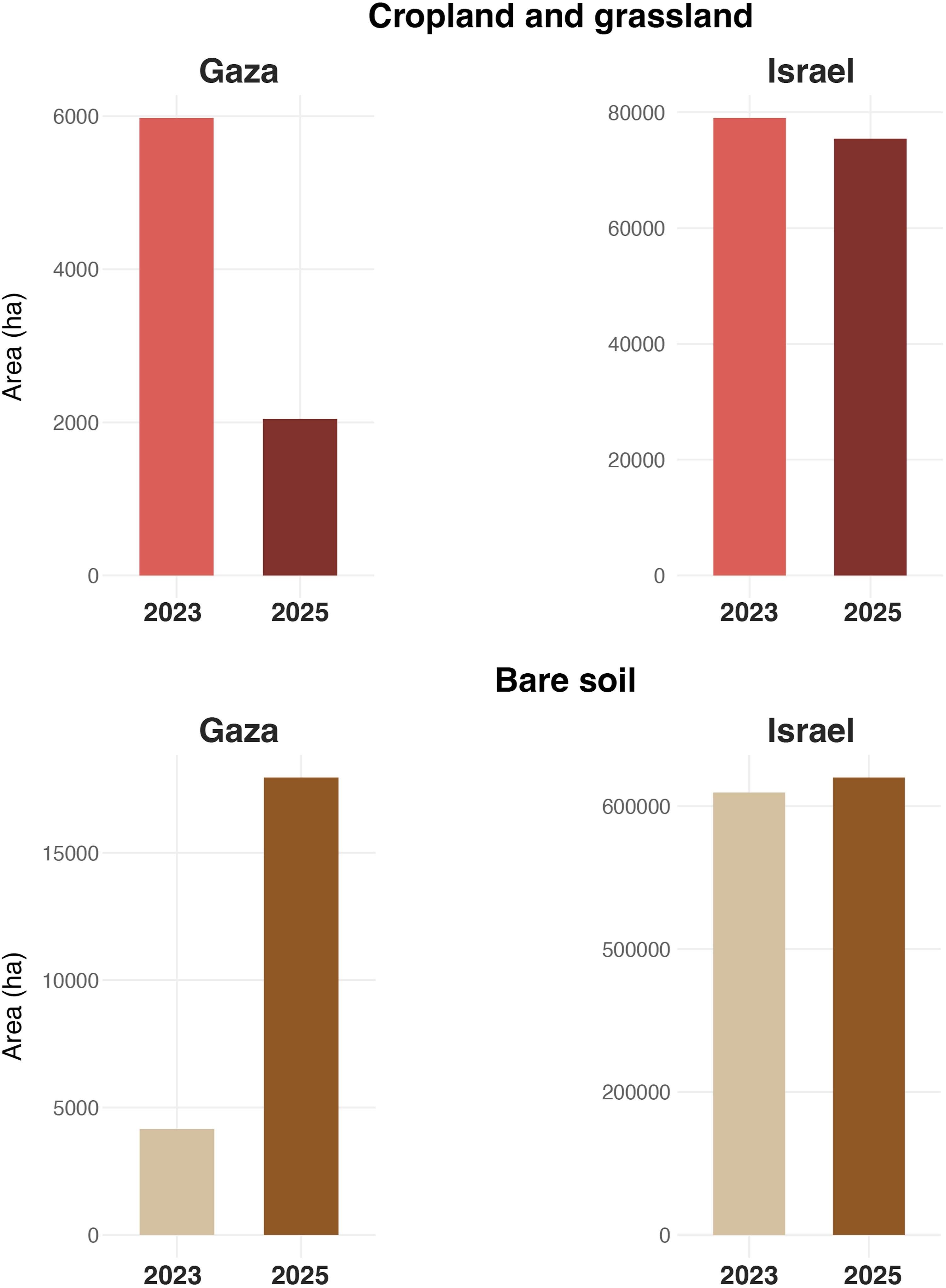
Over the same period in Israel, cropland and grassland decreased only slightly, from 79,009 to 75,434 ha (−3575 ha; −4.5%), whereas bare soil also increased slightly from 619,042 to 639,966 ha (+3.4%), indicating no comparable regional driver.
Overall, the spatial evidence highlights a severe loss of vegetation cover and expansion of bare soil in Gaza, revealing extensive soil exposure and surface disturbance, in stark contrast to the more stable land-cover patterns observed in Israel. This pattern shows a sharp contrast between areas inside and outside the Gaza Strip, where vegetation and croplands within the border have been almost entirely lost, accompanied by a pronounced expansion of bare soil. These environmental impacts are likely to persist for decades and will compromise Gaza’s food security and safety, as well as the recovery of its ecosystems (Koubi, 2019).
These findings align closely with those of Yin et al. (2025), who documented the conflict effects on agricultural areas using commercial optical data and machine-learning approaches trained on expert-labelled data. By extending the temporal scope to 2025, our work provides a broader and continuous perspective on the progression of land degradation. Also, we introduce a reproducible, open-source framework that not only strengthens but also facilitates collaborative assessment and recovery planning. Our results also support the broader interpretation advanced by Certini and Scalenghe (2023), who argued that warfare should be considered a major driver of soil degradation rather than merely a land-cover disturbance, with long-term impairment of ecosystem services.
This study relies on the Dynamic World dataset and does not include field-based validation, which was not feasible due to restricted access. However, Dynamic World v1 has been rigorously validated against expert-labelled reference data in previous studies (Brown et al., 2022), reporting an overall accuracy of 88.4% under strict expert agreement conditions, with particularly high user accuracy for crops (97.1%) and built areas (96.7%). Although higher-resolution commercial imagery (e.g. PlanetScope) could have provided additional confirmation, we intentionally chose not to use subscription-based data to maintain a fully open-source and reproducible workflow. Likewise, independent supervised classifications (e.g. Landsat-based) were not implemented, as such approaches depend strongly on training data selection and may introduce additional subjectivity and variability. To assess the robustness of our approach, we repeated the analysis using a September median composite instead of a single best-quality acquisition. Results were consistent with the original findings: in the Gaza Strip, bare soil increased by 340% between 2023 and 2025, while cropland and grassland declined by 69%. In contrast, Israel showed only minor changes over the same period (bare soil +3%; cropland −6%), confirming the stability of the detected trends.
In semi-arid environments, potential soil background effects may occur because sparse vegetation can influence spectral responses (Zeng et al., 2022). Still, Dynamic World integrates multispectral and spatial features using a deep learning model, thereby reducing sensitivity to soil reflectance.
In all cases, the magnitude and spatial coherence of the detected changes suggest that these limitations do not materially affect the overall data interpretation.
Building on our outcomes, we show that Earth Observation can be a crucial tool for assessing ecosystem damage and identifying severely affected areas for potential soil restoration under conditions of ongoing conflict and restricted ground access
While immediate and short-term consequences of conflict typically dominate global news cycles, the potentially long-lasting environmental consequences, affecting soil, vegetation, animal and human health (Mach et al., 2019), receive less or no attention. This is also in line with the most recent literature that reports war-related soil degradation remains underestimated compared to other forms of environmental damage (Certini and Scalenghe, 2023). Thus, we urge the international community, UN agencies, and policymakers to prioritise, alongside the management of sanitation, waste, energy, and transport infrastructure, the protection of soils and agricultural areas when assessing reconstruction and restoration efforts after conflict (Lal, 2015). We further call for the establishment of an independent Earth Observation-based monitoring system to support soil protection and restoration strategies worldwide.
More broadly, the impact of the Gaza conflict on the environment exemplifies how armed conflict leaves a lasting imprint on ecosystems, including soils, with serious environmental, health, and social consequences, as seen also in other recent conflicts such as in Ukraine, Syria, Yemen, and Sudan (Lacan et al., 2024; The Geneva Academy, 2025).
Although soil protection and ecological restoration are increasingly recognised in peacebuilding, they are still rarely prioritised or fully implemented. In practice, they tend to remain secondary to humanitarian relief, security, and infrastructure reconstruction needs, all of which require healthy functioning soils that deliver a myriad of supporting ecosystem services. Even when the loss of vegetation cover does not directly affect agricultural land, the transition from vegetated areas to bare soil or debris remains critical because it increases soil exposure, erosion and dust production, and can mobilise contaminants, compromising recovery conditions and soil health. Moreover, with a recognised explicit link between soil biodiversity loss and human health (Wall et al., 2015), there are further wide-reaching and long-lasting societal impacts. Accordingly, soil protection and land restoration should become explicit, monitored, and adequately funded components of recovery and reconstruction planning.
Footnotes
Funding
The authors received no financial support for the research. The authors thank the Autonomous Province of Bozen/Bolzano – South Tyrol for covering the open access publication costs.
Declaration of conflicting interests
The authors declared no potential conflicts of interest with respect to the research, authorship, and/or publication of this article.