
Abstract
In a traditional safety impact analysis, it is necessary to have crash data on existing roadway conditions and a few years must pass before accumulating additional crash data to evaluate the safety impact of an improvement. This is a time-consuming approach and there remains uncertainty in the crash data integrity. The surrogate safety assessment model (SSAM) was developed for resolving these issues. With SSAM, a conflict analysis is performed in a simulated environment. A planned improvement alternative is modeled and no physical installation of the alternative is needed. This study evaluated if SSAM can be used to assess the safety of a highway segment in terms of the number and type of conflicts and to compare the safety effects of multiple access management alternatives. An evaluation of the effect of converting a two-way left-turn lane (TWLTL) into a raised median on a section of an urban street was performed using SSAM working on VISSIM simulation’s trajectory files. The analysis showed that a raised median would be much safer than a TWLTL median for the same level of traffic volume, with approximately 32 to 50 percent reduction in the number of crossing conflicts. The analysis showed that about 34,000 to 38,000 veh/day would be the demand level where the median conversion is recommended for the four-lane study section. The study concluded that the combination of a simulation software program with SSAM could be a viable surrogate analysis approach for evaluating and comparing the safety effects of multiple access management alternatives.
The Access Management Manual, Second Edition defines access management as “the coordinated planning, regulation, and design of access between roadways and land development. It encompasses a range of access management alternatives that promote the efficient and safe movement of people and goods by reducing conflicts on the roadway system and at its interface with other modes of travel. These access management alternatives include improvements to benefit transit, pedestrians, and bicyclist, as well as different treatments for urban, suburban, and rural settings” ( 1 ).
One of the challenges with access management-related studies has been the availability of necessary data for conducting such studies. The Utah Department of Transportation (UDOT) began a light detection and ranging (LiDAR) data inventory in 2012 that includes access locations along all segments of the UDOT roadway network. The LiDAR inventory was repeated in 2014 and 2015. Combined with UDOT’s crash data, the availability of access point data allowed an in-depth safety-related study to find relationships among access density, access management alternatives, and crash occurrences ( 2 ).
Safety impacts of access management alternatives can be analyzed using before-and-after studies. However, in a traditional safety impact analysis it is necessary to install an access management alternative in the field and a few years must pass to accumulate reliable crash data. This is a time-consuming study and there remains uncertainty in the crash data as a result of the random nature of crash occurrences. To circumvent the use of crash data a method called a conflict analysis was developed, which is performed typically in the field. Although this method is free from the issues pertinent to crash data, it still requires time and cost because the safety improvement measure must be installed at the study site. The surrogate safety assessment model (SSAM) was developed in an attempt to ameliorate the issues related to safety impact evaluation described above. With this method, a planned access management alternative is simply added to the simulation model and no physical installation of the alternative is needed. Thus, it requires less time and less cost.
In this study, SSAM was tested to determine whether it could be used to evaluate safety impacts of access management alternatives, specifically a two-way left-turn lane (TWLTL) and a raised median. This paper presents a brief summary of the literature review, study methodology, calibration results, application of SSAM to safety impact evaluation, and conclusions.
Literature Review
The literature review of the study focused on traffic safety analysis methods using surrogate safety analysis measures. One of them is the traffic conflicts technique (TCT) and the other is SSAM. See Saito et al. ( 3 ) for an extensive literature review performed for the study.
TCT
The General Motors Research Laboratories (GMRL) originally developed the TCT in 1967 ( 4 ). TCT was performed in the field by observing and measuring crash potential on existing traffic facilities. Crash potential is defined as a conflict event, which is the occurrence of evasive vehicular actions and characterized by braking and weaving maneuvers forced by an impending collision or a traffic violation. Traffic violations are recorded as conflicts regardless of the presence of other vehicles. Five basic conflict categories were defined by GMRL including left-turn, weave, cross-traffic, red-light violation, and rear-end conflicts. The TCT has some strengths and limitations compared with the safety analysis based on actual crash records on specific facilities. Although the TCT analysis is free from the problems associated with the liability issues of crash records and the time required to wait for accumulating adequate sample sizes of crashes compared with the safety analysis method based on actual crash records, it still requires an existing facility that has enough traffic volume so that an adequate number of conflicts can be observed.
SSAM
SSAM was proposed by a research team at SIEMENS and was sponsored by the Federal Highway Administration. Gettman and Head ( 5 ) studied the potential for deriving surrogate safety measures from commonly available microscopic traffic simulation models, and their efforts eventually led to the development of the SSAM. Their study was followed by another study to test if SSAM could be used for practical engineering applications ( 6 ). The authors studied the relationship between simulated conflicts and actual crashes that took place at the studied intersections. They found that there was a significant relationship between the simulated conflicts and crashes ( 7 ).
SSAM is a post-processor of vehicle trajectory files produced by microscopic traffic simulation models. It operates by processing data describing the trajectories of vehicles driving through a simulated traffic facility and identifying conflicts. The vehicle trajectory input data for SSAM can be generated by traffic simulation software programs including VISSIM, Aimsun, Paramics, and TEXAS in a trajectory file format, specifically designed for SSAM. SSAM calculates surrogate measures of safety corresponding to each vehicle-to-vehicle interaction and determines whether or not each interaction satisfies the criteria to be deemed an official conflict. A table of all identified conflicts and their corresponding surrogate safety measures is then presented to the user ( 8 ). Conflicts identified by SSAM are crossing, rear-end, or lane-change movements, and the conflict angle determines conflict types as shown in Figure 1. The type is classified as a rear-end conflict if ||ConflictAngle|| <30 degrees, a crossing conflict if ||ConflictAngle|| >85 degrees, or a lane-change conflict otherwise. See Saito et al. ( 3 ) for a summary of surrogate safety parameters available in SSAM.
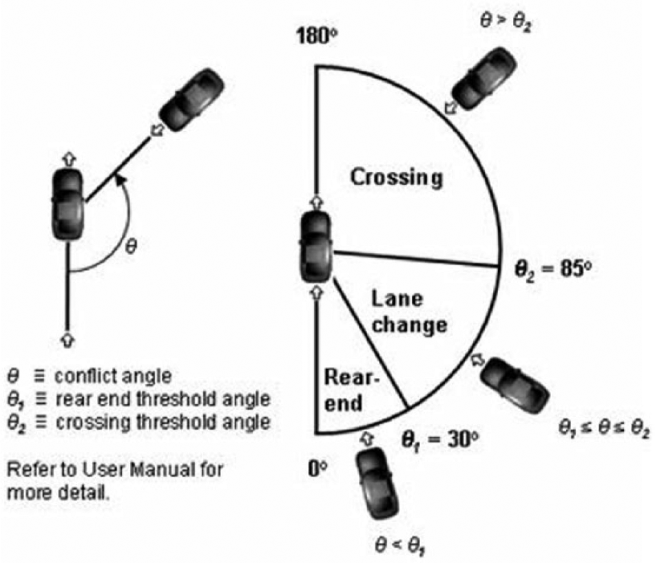
Conflict types by angle ( 8 ).
SSAM has been used in various traffic safety studies. For instance, Hummer et al. ( 9 ) evaluated operational, safety, and perceived effects of superstreets, called “restricted crossing U-turn intersections” using SSAM, and developed a level of service estimation program that could be used on North Carolina’s urban and rural arterial roadway system. Al-Ghandour et al. ( 10 ) studied conflict patterns at single-lane roundabouts with and without slip lanes and compared their performances using VISSIM and SSAM. The SSAM analysis showed that conflicts in the merge area were more frequent than in the roundabout approach area, and that the installation of a free-flow slip-lane exit type reduced overall conflict occurrence. Lee et al. ( 11 ) investigated safety aspects of the cooperative vehicle infrastructure system (CVIS)-based urban traffic control system by applying SSAM. They reported that the number of rear-end conflict events decreased by 58 percent under the CVIS-based control. Huang et al. ( 12 ) conducted a study to identify if the VISSIM simulation model combined with SSAM could provide reasonable estimates of traffic conflicts that might take place at signalized intersections. They reported that results of data analysis showed that there was a reasonable goodness-of-fit between the simulated and the observed rear-end and total conflicts. However, they found that the simulated conflicts were not good indicators for the traffic conflicts generated by unexpected driving maneuvers such as illegal lane-changes in the real world. Dijkstra et al. ( 13 ) conducted a large-scale study, in which a 300-km2 road network was modeled using Paramics. They collected six years of crash data from 569 pre-selected intersections in the road network. The study concluded that there was a significant statistical relationship between the observed crashes and the simulated conflicts.
Many more publications on SSAM application are available in the literature ( 14 – 17 ). Refer to Saito et al. ( 3 ) for a summary of these publications and others reviewed for the study. Although some studies have indicated that an overestimated number of conflicts were observed in the process, this literature review suggested that SSAM could be a viable tool to evaluate and compare safety effects of planned safety improvements on highways and intersections.
Study Methodology
The access management alternatives compared in this study included a TWLTL and a raised median. A section on Main St. (US-89) between 300 West and 500 East in American Fork was used because a 75-minute VISSIM model for this section was available from UDOT and the study section currently has a TWLTL. The study section is approximately 1.2 miles in length as shown in Figure 2. Both sides of the study section have various types of businesses and other land-use types. Because of the difference in average annual daily traffic (AADT), the study section was divided into two segments. Table 1 presents the characteristics of the two segments including the starting mile point, ending mile point, length, number of accesses, access density, and AADT. As shown in Table 1 the access densities of the two segments are similar, 62–63 accesses/mile, but their AADTs are quite different, which was the main reason to divide the study section into two segments.
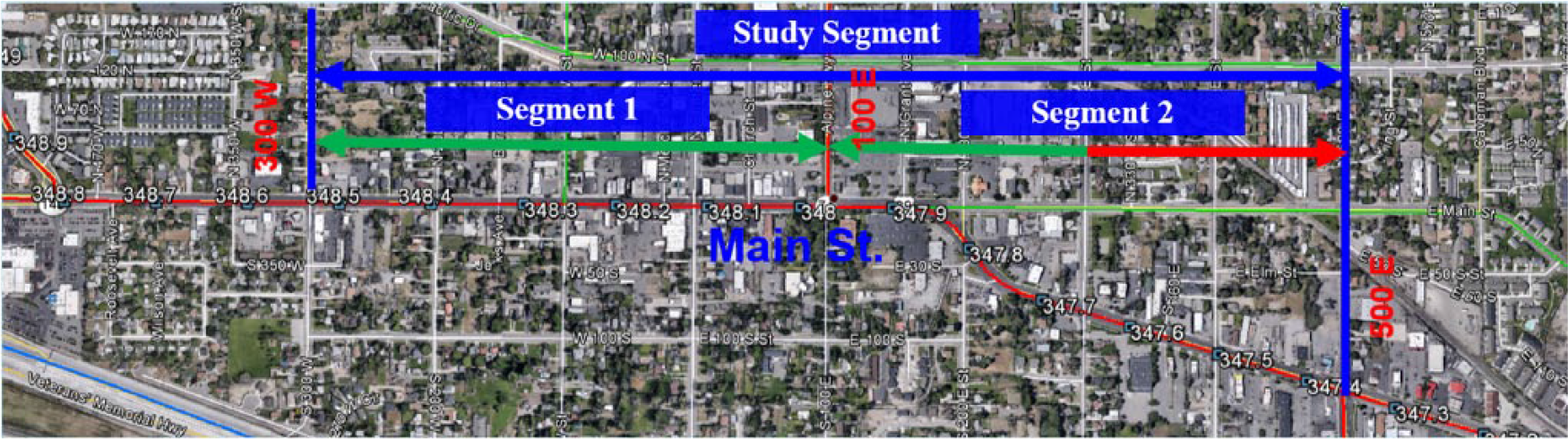
Main St. study section between 300 West and 500 East.
Characteristics of Each Segment of the Study Section ( 18 )
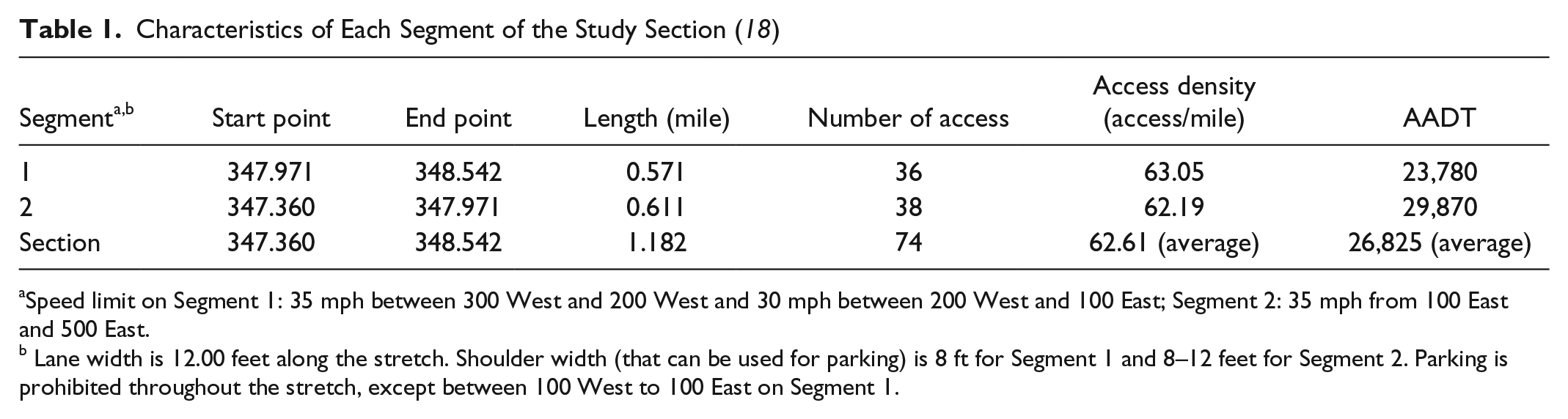
Speed limit on Segment 1: 35 mph between 300 West and 200 West and 30 mph between 200 West and 100 East; Segment 2: 35 mph from 100 East and 500 East.
Lane width is 12.00 feet along the stretch. Shoulder width (that can be used for parking) is 8 ft for Segment 1 and 8–12 feet for Segment 2. Parking is prohibited throughout the stretch, except between 100 West to 100 East on Segment 1.
The VISSIM model provided by UDOT did not contain all of the access driveways in the model. Therefore, all access driveways from the land uses along the study section were added to the model. Then, using the 8th Edition of the Institute of Transportation Engineers (ITE) Trip Generation Manual ( 19 ), potential trips generated by all the 74 access driveways for the 94 land uses located in the study section were added to the model.
In the first part of the task, before using SSAM for the safety evaluation, the Main St. VISSIM model was calibrated with 10 simulation runs by comparing the results of conflict frequencies and locations of the three types of conflicts with the actual crashes from the five-year crash data from year 2010 to 2014 ( 18 ). After the calibration work, safety impacts of a TWLTL and a raised median were evaluated. In the second part of the task, a sensitivity analysis was conducted to identify a threshold AADT at which a TWLTL is recommended to be replaced with a raised median. For this analysis, the traffic volumes of Main St. and access roads (driveways) to the land uses along the segment were increased at 10 percent increments up to a 40 percent increase. A preliminary analysis showed that beyond the 40 percent increase in volume the VISSIM model started having vehicle entry problems. Thus, five levels of Main St. volume and five levels of access driveway volume were modeled for each access management alternative from 1.0 to 1.4 with an increment of 0.1 (10 percent). A total of 25 combinations of traffic volumes were simulated for each alternative, totaling 50 combinations for both alternatives. Because of this large number of simulation combinations, each case was simulated three times for a total of 150 simulation runs.
Data Preparation
The original model provided by UDOT needed modifications to include all the driveways along the study section because to test the safety effects of access management alternatives, demands from each of these driveways become important. Three of the four steps of the classical urban traffic demand forecasting method were followed.
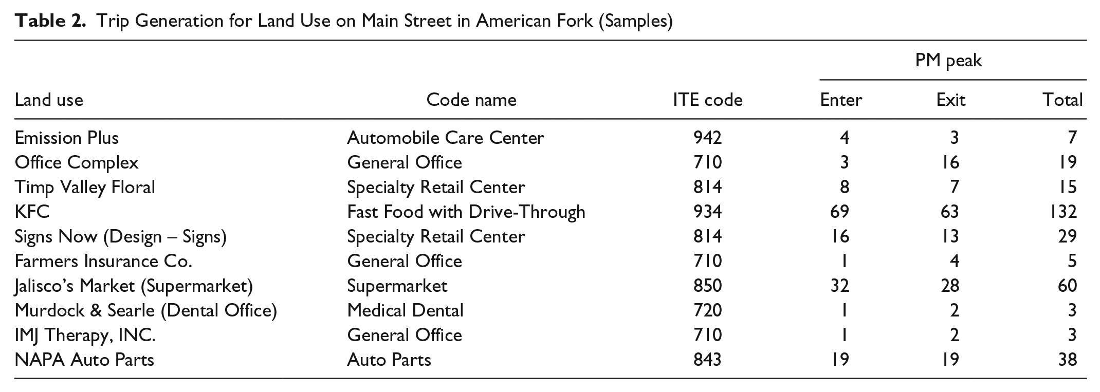
In the trip generation step, traffic volumes (number of trips) were generated for the existing land uses along the study section using the 8th Edition of the Trip Generation Manual ( 19 ). Table 2 presents several sample calculations of the 95 land uses found along the study section with their land use Code names, ITE codes, and PM peak traffic volumes. Since the PM peak period was modeled in VISSIM, the average trip rate for weekday PM peak hour was estimated and then multiplied by the area of each land use to get total trips generated. Then, the generated trips were divided into entering and exiting trips based on directional distribution rate provided in the Trip Generation Manual. The first land use listed in Table 1, Emission Plus, is used to explain this process. The store has 1,661-ft2 floor space. Its trip generation rate for the evening peak is 4.01 trips/1,000 ft2. This results in 1,661 ft2 × 4.01 trip/hour/1,000 ft2 = 7 veh/hour. The directional distribution is given as 51 percent entering, 49 percent exiting, resulting in 4 veh/hour entering and 3 veh/hour exiting, rounded to whole numbers to represent the number of vehicles as shown in the first data row of Table 2.
Trip Generation for Land Use on Main Street in American Fork (Samples)
Because traffic volumes and vehicle compositions in traffic volume on Main St. are given in the files provided by UDOT, the mode split step was omitted. In the trip distribution step, all entering and exiting traffic volumes on each land use was distributed to the trip origin or destination in the traffic simulation model. The trips for each land use estimated from the trip generation step were considered entering and exiting from the through traffic volume on Main St. of the study section as the total traffic volume on Main St. cannot be changed.
After the trip distribution step, all entering and exiting trips were assigned to each access driveway. In the TWLTL case, all entering and exiting trips from each access driveway were assigned to each starting end of eastbound and westbound links on the Main St. study site. Some trips, which make a left turn to enter an access driveway or exiting from the access driveway in the TWLTL case, use the TWLTL on Main St. In the case of a raised median, the trips that made a left turn using the TWLTL in the TWLTL case would use the nearest signalized intersection downstream to make a U-turn to complete their trips to their destinations such as access driveway or the east or west ends of Main St.
Analysis Results
The access management measures compared in this study were a TWLTL and a raised median. This section presents the results of the calibration of SSAM for the study section, a comparison of the safety impacts of these two median measures, and the results of a sensitivity analysis to find threshold values for replacing a TWLTL with a raised median.
Calibration of SSAM for the Study Section
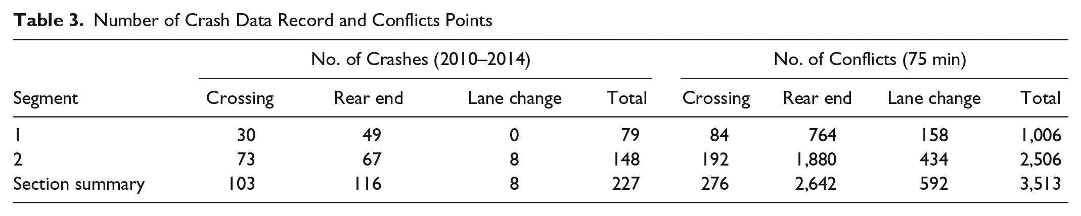
The simulation model was calibrated with 10 simulation runs before a comparative work was done. Table 3 shows the number of crashes from UDOT’s crash data ( 18 ) and the number of conflicts from SSAM. Both crashes and conflict types were grouped into three groups: crossing, rear-end, and lane-change crashes or conflicts. To compare the trend in actual crash occurrences and conflict points determined by SSAM, a relation index was set up, which is the ratio between the number of actual crashes divided by the number of conflicts. This normalization was needed because a direct comparison of the numbers of crashes and the number of potential conflict points could not be made because of the difference in the timeframes of these values. Table 4 presents the relation indices calculated for the two segments. Overall, the variation in relation indices was small, indicating the stability of the SSAM-based analysis.
Number of Crash Data Record and Conflicts Points
Number of Crash Data Record and Relation Indices
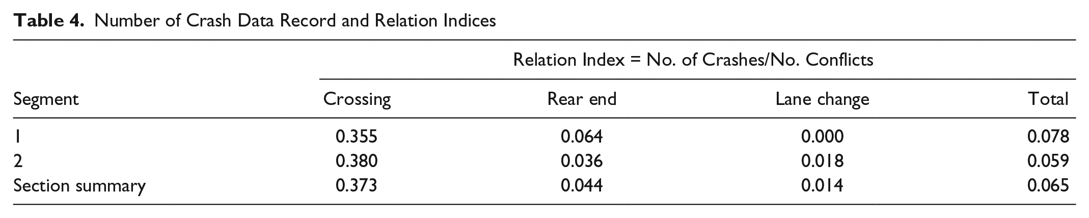
Figure 3 shows the spatial distributions of conflict points and actual crashes for Segment 1 of the study section. They are presented in pairs of three different conflict and crash types, namely crossing, rear-end, and lane-change crashes and conflicts. As shown in the figure, general trends in the location and concentration of crashes and conflicts are similar between the conflict points determined by SSAM and the crashes obtained from the crash data. Similar trends were found for Segment 2 ( 3 ).
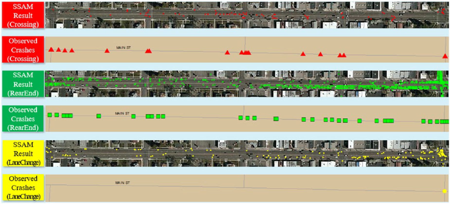
Spatial analysis of Segment 1 of the Main St. study section.
Use of SSAM for Evaluating Safety Impacts of Access Management Alternatives
With the SSAM calibrated, safety impacts of the two types of access management alternatives were compared. How much safety improvement can be made by installing a raised median? What would be the threshold of AADT to consider a raised median over a TWLTL? These are two typical questions traffic engineers would have in mind when considering replacing a TWLTL with a raised median. This exercise is an example of using SSAM as a tool to evaluate safety impacts of an access management alternative that can be implemented in the future.
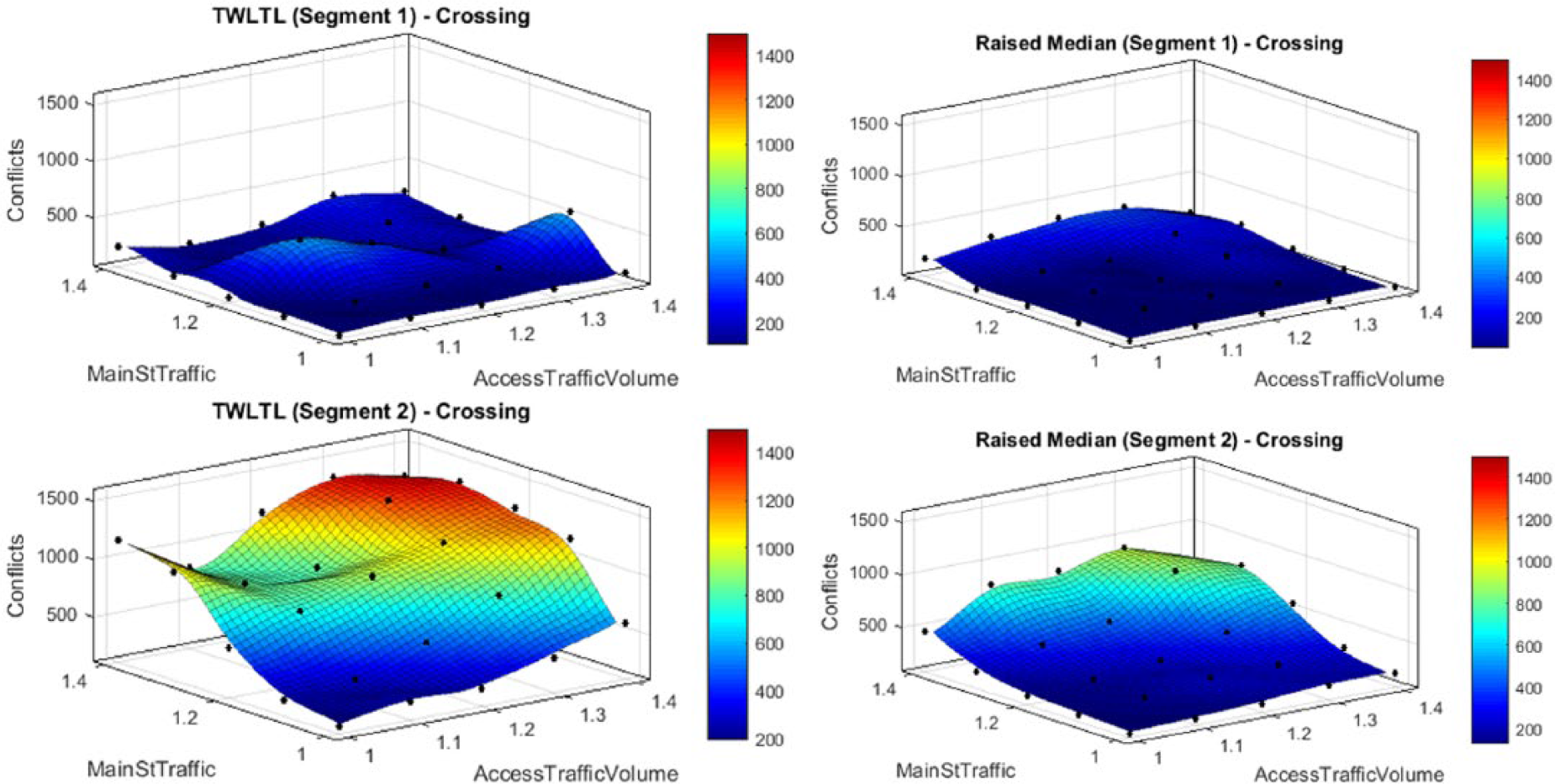
Figure 4 shows a three-dimensional presentation of the trend in the changes in average number of crossing conflicts at different volume level combinations. To allow easier interpretation of the analysis results, a top-view projection of Figure 4 was created, which presents the number of conflict points in “contours” of crash frequency as shown in Figure 5. The top-view projection provides an opportunity to evaluate at what level of volume combinations the number of conflicts would change significantly. The top-view projection provided a clue for answering the second question posed in the previous paragraph. See Saito et al. ( 3 ) for the results for the other conflict types and total number of conflicts.
Three-dimensional presentation of changes in the number of crossing conflicts.
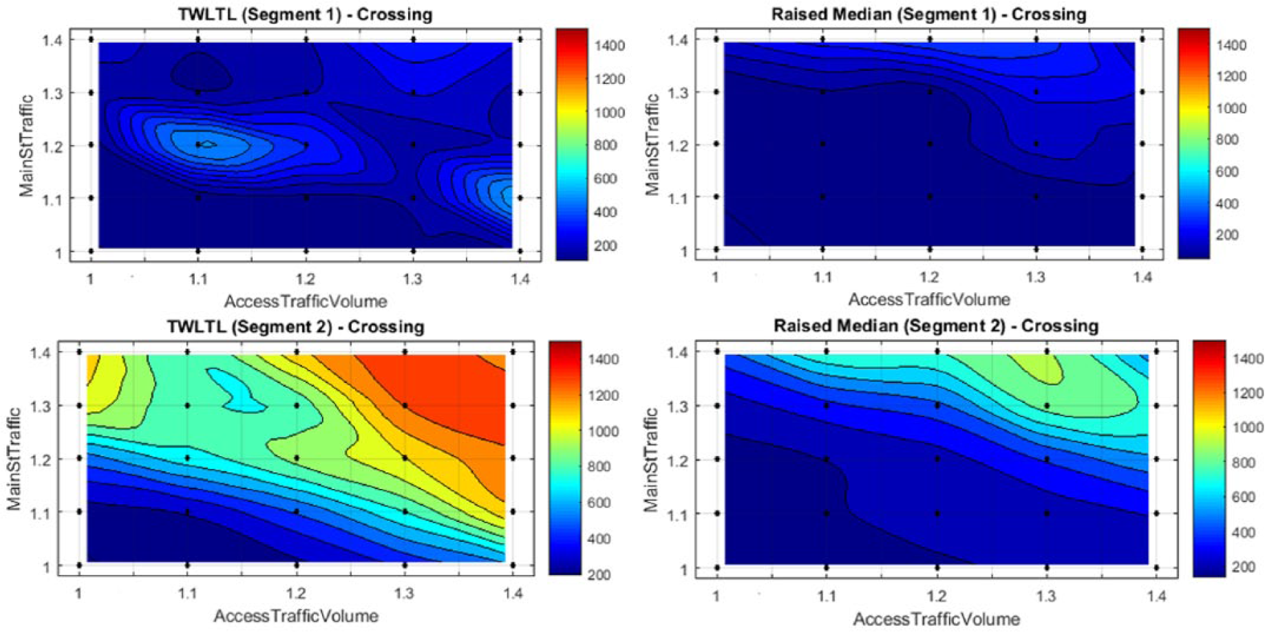
Top-view (contour maps) of crossing conflicts.
Since severe crashes tend to occur in crossing conflicts, the crossing conflict type is used to discuss general trends manifested by the conflict level contours. As shown in Figure 5, the numbers of crossing conflicts are quite similar between the TWLTL and the raised median in Segment 1, while they are significantly different between the two median types in Segment 2. The 2014 AADT of Segment 1 is 23,780 veh/day and AADT of Segment 2 is 29,870 veh/day, as shown in Table 1. Therefore, it can be said that at approximately 24,000 veh/day there is not much difference in safety-related benefits between these two alternatives even after volume increases. As AADT increases, however, the raised median begins to provide much safer traffic conditions compared with the TWLTL, as demonstrated in Segment 2 of the study site as shown in Figure 5. For example, the number of crossing conflicts for the TWLTL through Segment 2, with a 40 percent volume increase on Main St., ranges from 800 to 1,400, whereas the number of crossing conflicts for the raised median, with the same 40 percent volume increase on Main St., ranges from 400 to 900, a 32 percent to 50 percent reduction in crossing conflicts in Segment 2. Although the range of the number of conflict events for each conflict type differs among other conflict types, a similar trend was observed for rear-end and lane-change conflicts ( 3 ).
Results of the Sensitivity Analysis
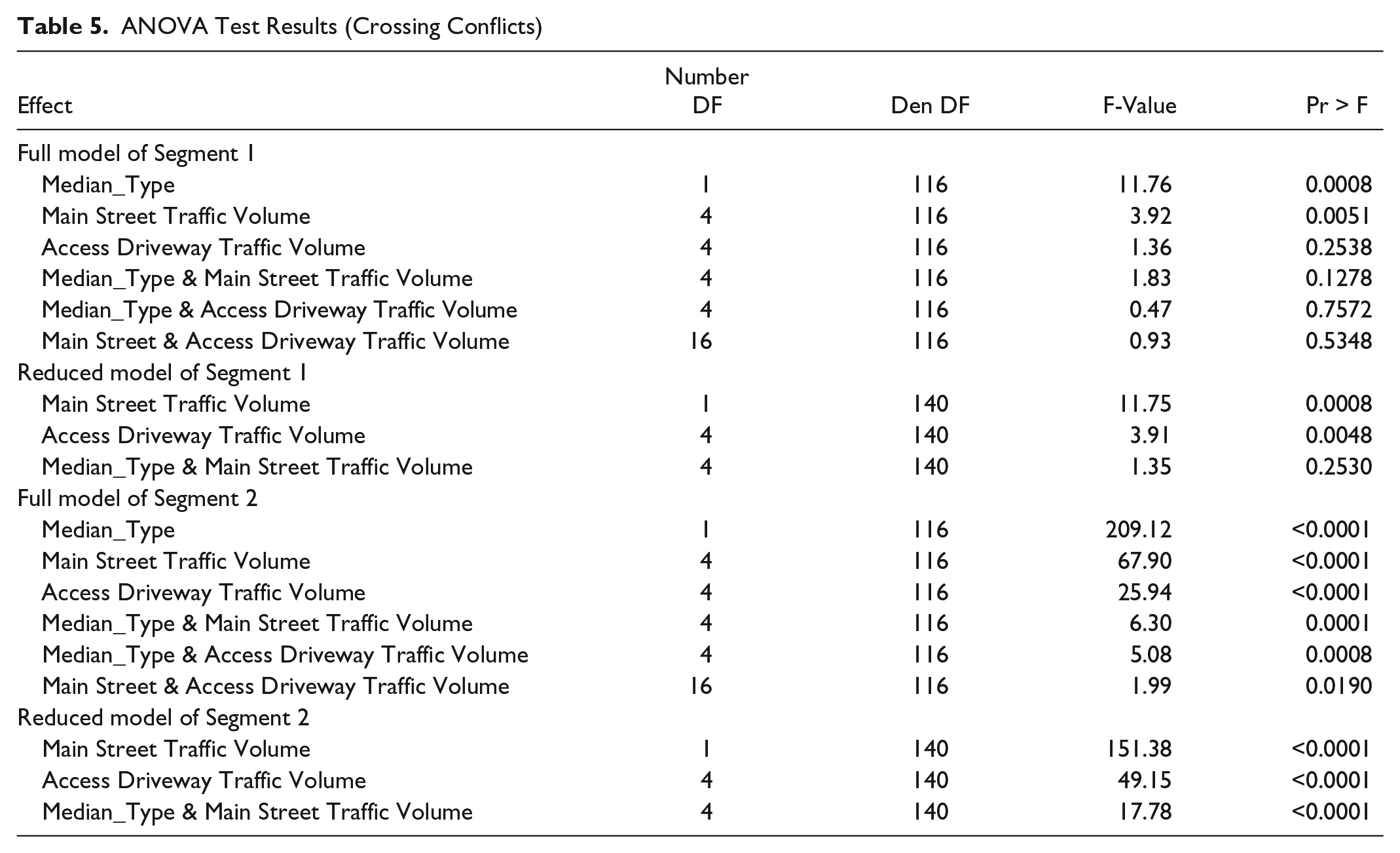
Table 5 shows a brief summary of an analysis of variance (ANOVA) on crossing conflicts for Segment 1 and Segment 2. The ANOVA analysis showed that median type was the most dominant factor that would affect the number of conflicts followed by the volume on Main St., followed by the volume on access driveways. Although there were some interactions among the main factors, their contributions are much smaller than the three main factors. It was found that there was not much difference in the number of crossing conflicts in Segment 1, which had an AADT of 23,780 veh/day. In Segment 2, the differences in the number of crossing conflicts were significant, as shown in Figure 5. Segment 2 had an AADT of 29,870 veh/day. Note that both segments have similar access densities, as shown in Table 1.
ANOVA Test Results (Crossing Conflicts)
To determine the threshold traffic volume for replacing a TWLTL with a raised median, cyan-colored contours were assumed as the upper threshold for using a TWLTL and the lower threshold to justify a raised median. This cyan-colored contour was selected as a potential threshold value because the cyan-color contour does not appear in Segment 1 either with a TWLTL median or with a raised median, as shown in Figure 5. This means that both access management measures have a similar performance in Segment 1 with AADT of approximately 24,000 veh/day. Because the most critical conflict type is crossing conflicts, it was decided to use the crossing conflict to find the threshold AADT to discuss the benefit of installing a raised median. In Figure 6, the cyan-colored contour represents the number of crossing conflicts of about 600. Therefore, the number of vehicles per lane for Main Street and its access demand combinations that are on or near the cyan-colored contour were determined.
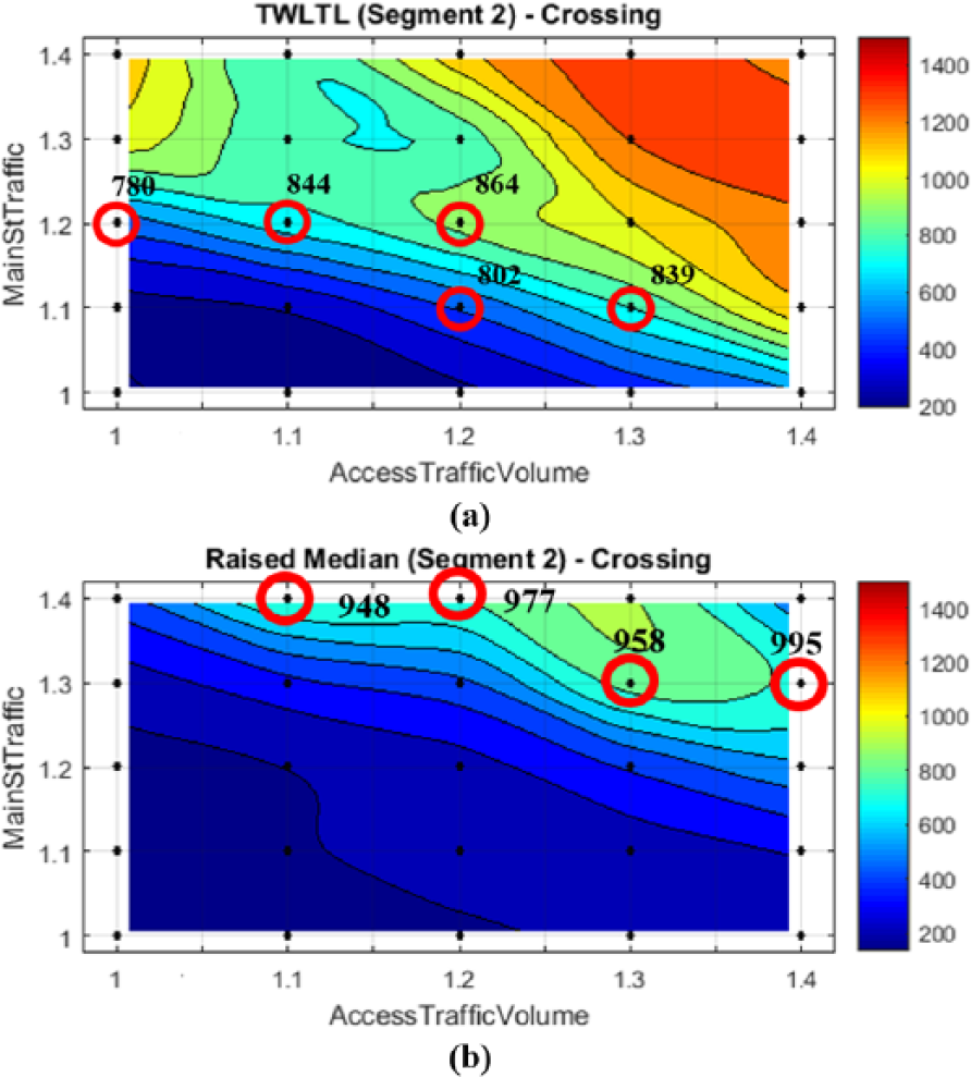
Threshold volume analysis results for crossing conflicts; (a) TWLTL median; (b) Raised median.
Figure 6 shows the results of this threshold traffic-volume analysis for TWLTL and raised medians. The numbers shown in Figure 6 are the numbers of vehicles per hour per lane (veh/hr/ln) that would result in about 600 crossing conflicts for each segment. With the threshold of crossing conflicts in Segment 2 being set to approximately 600, traffic volumes on or near the cyan-colored contour were determined and they were found to be approximately 780 to 864 veh/hr/ln. With the raised median, traffic volumes on or near the cyan-colored contour were determined to be 948 to 995 veh/hr/ln. The raised median can accommodate 84 to 215 veh/hr/ln more to reach the same level of crossing conflicts for the TWLTL.
Knowing that the study segments have four lanes (a total of the number of lanes in both directions), the threshold traffic volume to convert a TWLTL to a raised median would be approximately 3,120 to 3,460 veh/hr (780 × 4 = 3,120 and 864 × 4 = 3,456), as shown in Figure 6. Since the percentage of the current PM peak hour volume against AADT for the Main St. in the study area is about 9 percent (estimated using traffic volume in the VISSIM model provided by UDOT and AADT available from UDOT for year 2014 ( 18 )), the threshold AADT for considering replacing a TWLTL with a raised median would be approximately 34,700 to 38,400 veh/day for the four lanes in Segment 2 (two lanes in each direction). A raised median may begin to have a similar level of crossing conflicts as the one for the TWLTL when the hourly volume becomes approximately 3,790 to 3,980 veh/hr (948 × 4 = 3,792 and 995 × 4 = 3,980). With these hourly values, the AADT where a raised median might begin to have an increase in the number of crossing conflicts similar to the case with a TWLTL would be approximately 42,100 to 44,200 veh/day for Segment 2 of this study section.
As for safety improvement after replacing the TWLTL with the raised median, an approximate 32 to 50 percent reduction in the number of crossing conflicts was achieved when a raised median was used in lieu of a TWLTL when traffic volumes were increased by 40 percent of the base model at the Main St. study section. The percent reduction in crossing conflicts caused by changing a TWLTL with a raised median resembles the result of the Schultz et al. ( 2 ) study that was conducted in parallel to this study. The study compared crash occurrences before and after a change in median treatment from a TWLTL to a raised median at 20 study sites statewide, using Bayesian statistics. The study concluded that the median type change achieved crash reduction ranging from 32 to 44 percent for all severity groups except severity 4 and 5, for which a larger reduction of 57 percent and 58 percent, respectively, was achieved. These values are similar to the results of crossing conflict analysis.
Conclusion
With SSAM, a conflict analysis is done in a simulated environment; therefore, the physical and traffic characteristics of before and after can be maintained for before and after analyses. A planned access management alternative under study is modeled and no physical installation of the alternative is needed. Also, this conflict analysis is not affected by uncertainty inherent to crash data. The goal of this study was to evaluate if SSAM could be used to assess the safety impact of an access management alternative and to compare the safety impacts of multiple access management alternatives with less time, less cost, and less uncertainty.
In conclusion, the calibration and sensitivity studies conducted in this study showed that SSAM combined with a simulation model could be a viable tool to evaluate the safety impacts of access management alternatives planned for future implementation and a complement to traditional crash-based and in-field conflict analyses. In this study, conversion of a TWLTL into a raised median was evaluated to answer the two frequently asked questions related to such conversion: (1) How much safety improvement can be made by installing a raised median replacing a TWLTL? And (2) What would be the threshold of AADT to consider a raised median over a TWLTL?
The analysis showed that a raised median would be much safer than a TWLTL for the same level of traffic volume. An approximate 32 to 50 percent reduction in the number of crossing conflicts could be achieved. This is the answer to the first question mentioned in the paragraph above. Assuming a certain level of conflict occurrence level as a potential threshold to convert from a TWLTL to a raised median and the PM peak hourly volume percentage of 9 percent of AADT, average threshold daily traffic volumes in the study section were estimated. In this study, the threshold level was set to 600 crossing conflicts based on a typical trend observed in the outcomes of the analysis. The analysis showed that AADT of about 34,000 to 38,000 veh/day would be the demand level where a TWLTL is recommended to be converted into a raised median for the four-lane segments in the study segments. Also found was that the performance of a raised median might begin deteriorating once AADT becomes approximately 42,000 to 44,000 veh/day for the four-lane segments analyzed in this study. This is the answer to the second question mentioned in the paragraph above.
Footnotes
Acknowledgements
This research was made possible with funding from UDOT. Special thanks to Robert Miles, Tony Lau, Vincent Liu and the other members of the UDOT’s Technical Advisory Committee for this study.
Author Contributions
The authors confirm contribution to the paper as follows: study conception and design: Kyung Min Kim, Mitsuru Saito, Grant G. Schultz; data collection: Kyung Min Kim, Mitsuru Saito; analysis and interpretation of results: Kyung Min Kim, Mitsuru Saito, Grant G. Schultz, Dennis L. Eggett; draft manuscript preparation: Kung Min Kim, Mitsuru Saito, Grant Schultz. All authors reviewed the results and approved the final version of the manuscript.
The Standing Committee on Access Management (AHB70) peer-reviewed this paper (18-00280).
The contents of this paper reflect the views of the authors, who are responsible for the facts and accuracy of the information presented here, and are not necessarily representative of the sponsoring agency.