
Abstract
Metropolitan planning organizations (MPOs) providing funding for local land use planning is part of a growing trend which has so far received very little attention. This study surveyed a stratified sample of 30 U.S. MPOs weighted toward larger metropolitan areas. Of the 30 MPOs, about half were funding smart growth-oriented local land use planning through transportation and land use connection (TLC) programs. From them, 10 MPOs with TLC programs were selected and written up as case studies. Across the case studies it was found that the funding and support provided differs greatly by region. The ultimate goal of these programs was similar, however—to reduce suburban sprawl and the associated need for highway building, and instead to create more livable, sustainable, walkable, bikeable, and transit-accessible communities within the region. These gaols were achieved by promoting infill and development in and around urban centers, and encouraging concentration of activity around transit stations. With the exception of one program, funding portfolios have grown year by year. While project funding selection criteria differ across MPOs, how well they align with the region’s transportation plan seems to be of paramount importance.
It is conventional wisdom that land use planning is the exclusive purview of local governments exercising zoning powers. Therefore, the role of metropolitan planning organizations (MPOs) and state departments of transportation (DOTs) is just to satisfy travel demands created by local land use decisions, or so the argument goes. The obvious rebuttal, however, is that highway investment affects development patterns, sometimes referred to as highway-induced development ( 1 , 2 ) or “sprawl.” Transit investments do so as well, but in a much more benign way. Transportation agencies may not always plan for future land use patterns (increasingly they do), but their actions inevitably affect future land use patterns.
Around 2013 the Wasatch Regional Front Council, a regional MPO, became aware of the fact that MPOs in California were setting aside small amounts of highway money for grants to local governments to undertake smart growth land use planning, all in an effort to maximize the value of investment in public infrastructure in the future. What is now called the transportation and land use connection (TLC) program was born.
It turns out that MPOs providing funding for land use planning is part of a larger trend, but little is known about this important movement. This study profiles that emerging trend by surveying a stratified sample of 30 U.S. MPOs weighted toward larger metropolitan areas. Of the 30, about half of the MPOs were funding smart growth-oriented local land use planning through TLC programs. From that group a sub-sample of 10 were selected for detailed case studies. This paper presents the 10 case studies, which the authors believe are representative of exemplary MPO practice. The paper is further output of the research published in the 2018 book, Best Practices in Metropolitan Transportation Planning ( 3 ).
This paper explores general trends and the ways in which MPOs are connecting transportation and land use in their work. More specifically, it answers important questions about planning practice. What actions are MPOs taking as part of TLC programs, and what types of projects are they funding to connect transportation and land use? The findings of this paper will help planners understand this emerging movement better, shed light on the issues of coordination in practice, and highlight strategies that make coordination effective.
Background
Urban development patterns affect travel behavior in a number of significant ways. On the most basic level, dispersed land use patterns have been linked to automobile dependency and inefficient public transportation systems ( 4 , 5 ). By contrast, compact development patterns have been linked to lower rates of automobile crashes ( 6 , 7 ), reductions in air pollution and greenhouse gas emissions ( 8 – 11 ), and more efficient public transport systems ( 12 , 13 ). Transportation can also affect land use. In many metropolitan areas, investments in transportation infrastructure designed to improve mobility by increasing travel speeds have enabled highway-induced development which disperses origins and destinations over a wide geographical area ( 1 , 2 , 9 ).
When it comes to planning transportation infrastructure investments in U.S. metropolitan areas, there is a disconnect between land use and transportation planning which dates back to the emergence of regional transportation planning in the U.S.A. A number of factors explain the lack of coordination between land use and transportation planning. One is that a dearth of planning capacity—in the form of funding, staff, technical expertise, models, and other technology—limits the ability of many MPOs to address regional issues beyond their core responsibility of preparing a long-range regional transportation plan and a short-range transportation improvement program ( 14 – 17 ). Another is that inequitable representation on many MPO governing boards gives outsize influence to suburban jurisdictions which compete with one another for tax revenues and have more of an interest in expanding new transportation infrastructure than in maintaining or rehabilitating existing infrastructure in urban centers ( 18 ). But the single biggest hurdle to integrating land use and transportation planning is a legal one. Namely, states typically delegate authority to regulate land uses through zoning and other police powers to local governments, which leaves MPOs with little influence in decisions about land use ( 19 ).
For most local governments, compliance with plans produced by MPOs is voluntary ( 20 – 22 ). This means MPOs have come to rely on incentives such as funding to implement their regional visions. In the late 1990s and early 2000s, some MPOs pioneered new programs to help connect, coordinate, and integrate transportation and land use planning. The Metropolitan Transportation Commission of the San Francisco Bay area and the Atlanta Regional Commission in Georgia were the first two MPOs to provide grant funding to local governments to encourage smart growth planning and development. Since these trailblazing initiatives, other regional planning organizations have launched their own programs. A 2012 study examining these programs investigated the programs of four MPOs and assessed their efforts at coordinating land use and transportation, with in-depth analysis of their governance, coordination, growth centers, and transportation improvement programs ( 4 ).
The programs studied have included measures to encourage the location of housing, jobs, and services closer to transit corridors and to improve multimodal station connections and networks to make communities more walkable, bikeable, and transit-friendly ( 4 ). Over the ensuing years, the number of MPOs involved in such programs increased dramatically. To understand this movement better, the authors conducted a survey of 30 MPOs, taking a stratified sample weighted toward larger MPOs. Of the 30, about half of the MPOs now fund smart growth-oriented local land use planning. Interestingly, each MPO labeled its program differently (see Table 1). Among these names, it seems that the acronym TLC is widely used by MPOs, including the Wasatch Front Regional Council. Hence, TLC is used to describe these types of programs in the rest of the paper.
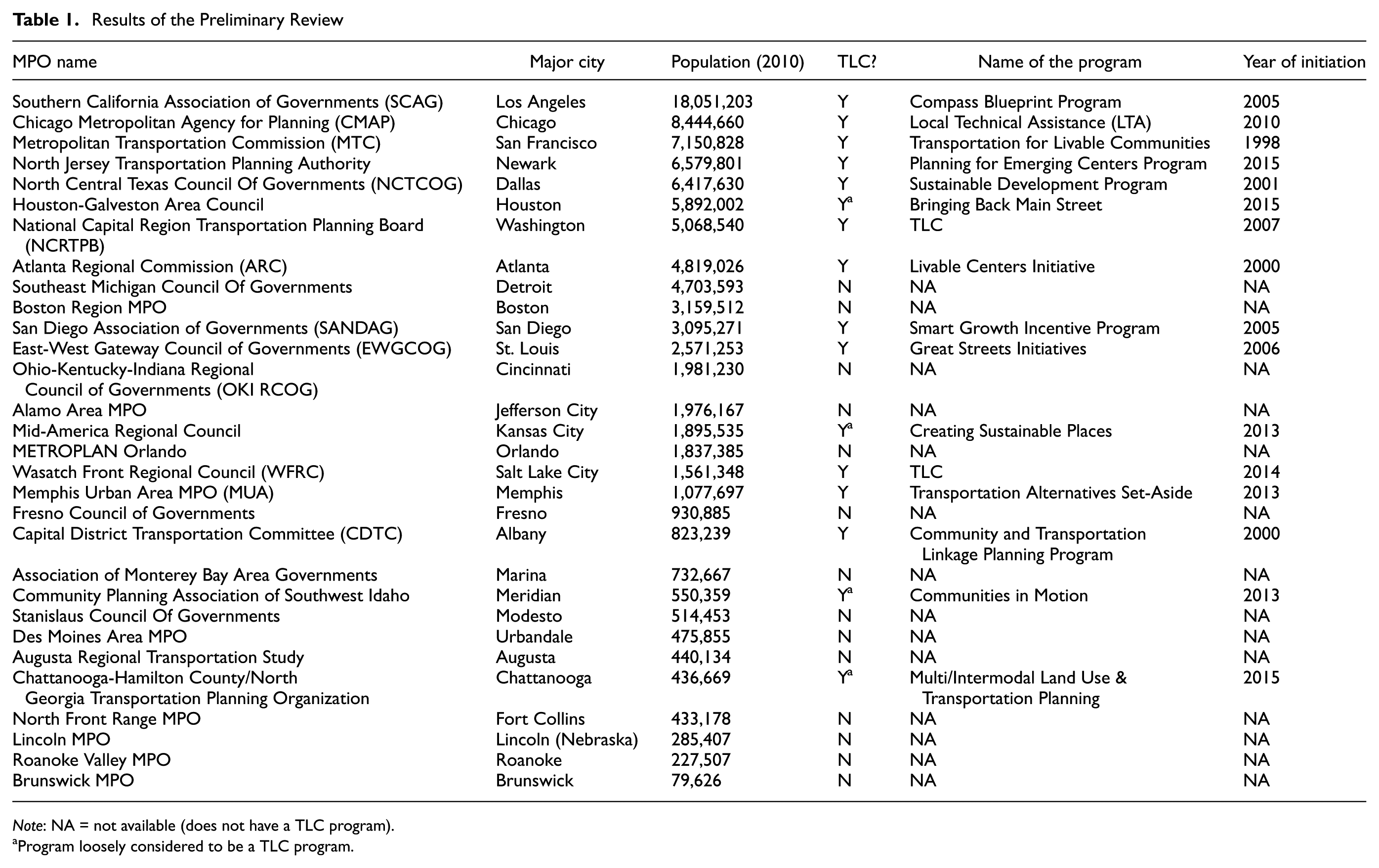
Results of the Preliminary Review
Note: NA = not available (does not have a TLC program).
Program loosely considered to be a TLC program.
Methodology
This paper presents comparative case studies of TLC programs in 10 regions. TLC programs are defined here as providing grants to local governments to conduct smart growth activities which reduce the need for highway expansion projects and also increase sustainability, livability, walkability, and bikeability, and finally create more transit accessible communities.
The research is based on a survey of 30 MPOs, taking a stratified sample which is weighted toward larger MPOs. For all MPOs, the research team reviewed their websites, documents, and research reports to find details on their TLC or similar program. Among these 30 MPOs, more than half have this kind of program. Table 1 shows the results of the preliminary review. The first step was to check the website of each MPO to see whether it had a TLC program or not. The research team then contacted the majority of MPOs which did not have information on their website to confirm that they did not have TLC programs.
Finally, for the purpose of this research, the study focused on 10 MPOs, with programs (or similar), which were diverse in relation to geographic location, size, and service area. Figure 1 shows the location of these 10 MPOs in the U.S.A. For each MPO, the documents, research reports, and published research were reviewed and an initial description of each MPO’s TLC program was drafted. The research team then contacted the TLC program manager at each of the 10 case study MPOs with programs and asked him/her to revise and update the information in the draft description. Planners at all 10 MPOs responded to these requests, allowing the researchers to engage in informal conversations via email and telephone. In several cases, these conversations resulted in multiple rounds of revisions to the case studies. Questions were asked about the goals of their program, the program’s budget and the funding amounts, the sources of funding, the types of projects they fund, who may apply, how long the program has been in place, and, finally, the possible impacts of this program in each region.
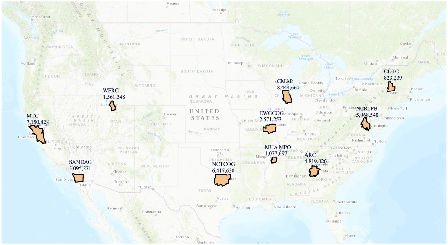
Case study regions.
Case Studies
Chicago Metropolitan Agency for Planning
The Chicago Metropolitan Agency for Planning (CMAP) started providing local planning assistance in 2010 by initiating a program called Local Technical Assistance (LTA) with a $4.25 million grant. The LTA program provides planning, and in some cases financial, assistance to communities across the region to undertake projects such as developing sub-area plans for specific commercial or industrial districts, sustainability plans, and parking management.
The ultimate goal of the LTA program is to increase livability, sustainability, and economic vitality. Since 2012, 200 projects have been selected which address local issues at the intersection of transportation, land use, and housing, including the natural environment, economic growth, and community development.
Currently, CMAP is working with more than 100 local governments and nonprofit organizations to implement effective local plans that align with GO TO 2040 and ON TO 2050, the region’s next comprehensive plan. Municipalities, counties, townships, municipal associations, groups of two or more municipalities located within CMAP’s seven-county region, the regional transportation authority service boards (CTA, Metra, Pace), and non-governmental organizations (with some conditions) are eligible to apply for assistance. The LTA program documentation lists the following criteria for the selection of projects ( 23 ):
Support development of compact, walkable communities;
Match regional and local housing supply with the types that residents want;
Advocate for and develop policies that strengthen communities and the transit system;
Encourage multi-jurisdictional partnerships and study areas;
Make transit more competitive;
Target disinvested and economically disconnected areas;
Leverage the transportation network to promote inclusive growth.
The initial $4.25 million funding was provided by a Sustainable Communities Regional Planning grant from the U.S. Department of Housing and Urban Development. Since then, the program has been supported by the U.S. DOT, U.S. Economic Development Administration, Illinois Attorney General, Illinois Department of Natural Resources, Illinois Environmental Protection Agency, The Chicago Community Trust, the John D. and Catherine T. MacArthur Foundation, and Cook County. Although it is too early to measure the effectiveness of this program, the executive director of CMAP stated that “the LTA program has a strong record of success in helping communities to create and implement their own plans” ( 24 ).
In October 2017, 34 new LTA projects (see Figure 2) were approved by the CMAP board. Projects that focus on implementing previous LTA plans, collaborating across multiple jurisdictions, or planning in communities with the highest need for assistance (based on median income, local tax base, and size) have higher priority. Several of the plans approved as part of the 2017 LTA Program are multi-jurisdictional plans that bring communities together to work toward collaborative goals. For example, a project approved in Beach Park, in partnership with North Chicago, Waukegan, Winthrop Harbor, Zion, and Lake County, focused on trail connections and lakefront access along Lake Michigan.
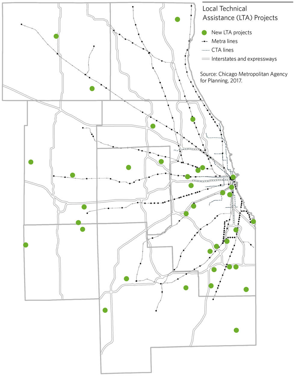
New CMAP LTA projects ( 23 ).
Metropolitan Transportation Commission
The San Francisco Bay region’s MPO, the Metropolitan Transportation Commission (MTC), may have been the first MPO to set aside transportation funds for local planning efforts under a program called Transportation for Livable Communities. This program was created in 1998, reportedly one year before Atlanta’s program, and helped set the stage in 2007 for the FOCUS program, which encouraged local governments to designate priority development areas (PDAs) within their jurisdictions.
PDA is locally designated land where future growth can be channeled at sufficient densities to take advantage of existing infrastructure and services, especially transit services. PDA consists of three components: (i) the PDA Planning Program funds specific plans which result in denser land uses around public transit hubs and bus and rail corridors in the nine-county San Francisco Bay Area (maximum award: $800,000); (ii) the PDA Technical Assistance Program provides customized consultant assistance to complete discrete projects which allow a city to overcome specific policy or planning challenges in the adoption or implementation of PDA plans (maximum award: $65,000); (iii) the PDA Staffing Assistance Program addresses staff reductions which have limited the ability of cities to carry out work critical to implementing PDA plans and Plan Bay Area (maximum award: $200,000) ( 25 ).
To implement Plan Bay Area, the most recent sustainable communities strategy/regional transportation plan, MTC prioritizes capital and planning funds for PDAs through its One Bay Area Grant (OBAG) program, which builds upon Transportation for Livable Communities and FOCUS. FOCUS provided funding support via capital infrastructure funds, planning grants, and technical assistance to communities. PDA plans funded through FOCUS and OBAG have created zoning capacity for 90,000 housing units. Over the past 10 years, MTC has funded 51 planning grants totaling nearly $24 million and 33 projects totaling $1.8 million in the Technical Assistance and Staffing Assistance programs.
All jurisdictions are eligible to apply for PDA planning funds, however, priority will be given to the 16 jurisdictions taking on over 70% of the region’s housing growth in Plan Bay Area 2040. Projects are evaluated on a 100-point scale which takes into account effects on population at high risk of displacement, alignment with regional transportation plan, overall impact, transportation agency support, and more.
San Diego Association of Governments
The San Diego Association of Governments (SANDAG) initiated the Smart Growth Incentive pilot program in 2005. The success of the pilot program led to the creation of a much larger TransNet Smart Growth Incentive Program in 2009. This was complemented by an Active Transportation Grant Program in 2009.
The purpose of the pilot program was to showcase exemplary smart growth land development around the region. The program was designed to promote a mix of well-designed, higher intensity development in the existing urbanized areas, community and town centers, and rural villages, supported by infrastructure encouraging alternatives to driving alone. The successor programs simply scaled up the pilot program, building on its popularity and success.
Under the pilot program, the MPO awarded $22.5 million in grants for local smart growth development projects. Funding originally came from the federal Transportation Enhancements program. The success of the pilot program led to the creation of a $280 million Smart Growth Incentive Program and a $280 million Active Transportation Grant Program funded by a half-cent local sales tax. Each of these programs amounts to 2% of the revenues generated by the sales tax. Not including the pilot program, SANDAG has awarded more than $80 million to more than 140 projects throughout the San Diego region.
To be eligible for these funds, and receive priority for other funding, local governments designated more than 200 existing, planned, or potential “smart growth opportunity areas” to which dense mixed-use development is being directed. These areas are shown on the Smart Growth Concept Map (see Figure 3). Every single jurisdiction in the San Diego region was able to identify at least one smart growth opportunity area on the map, demonstrating region-wide support for the smart growth principles included in the regional comprehensive plan
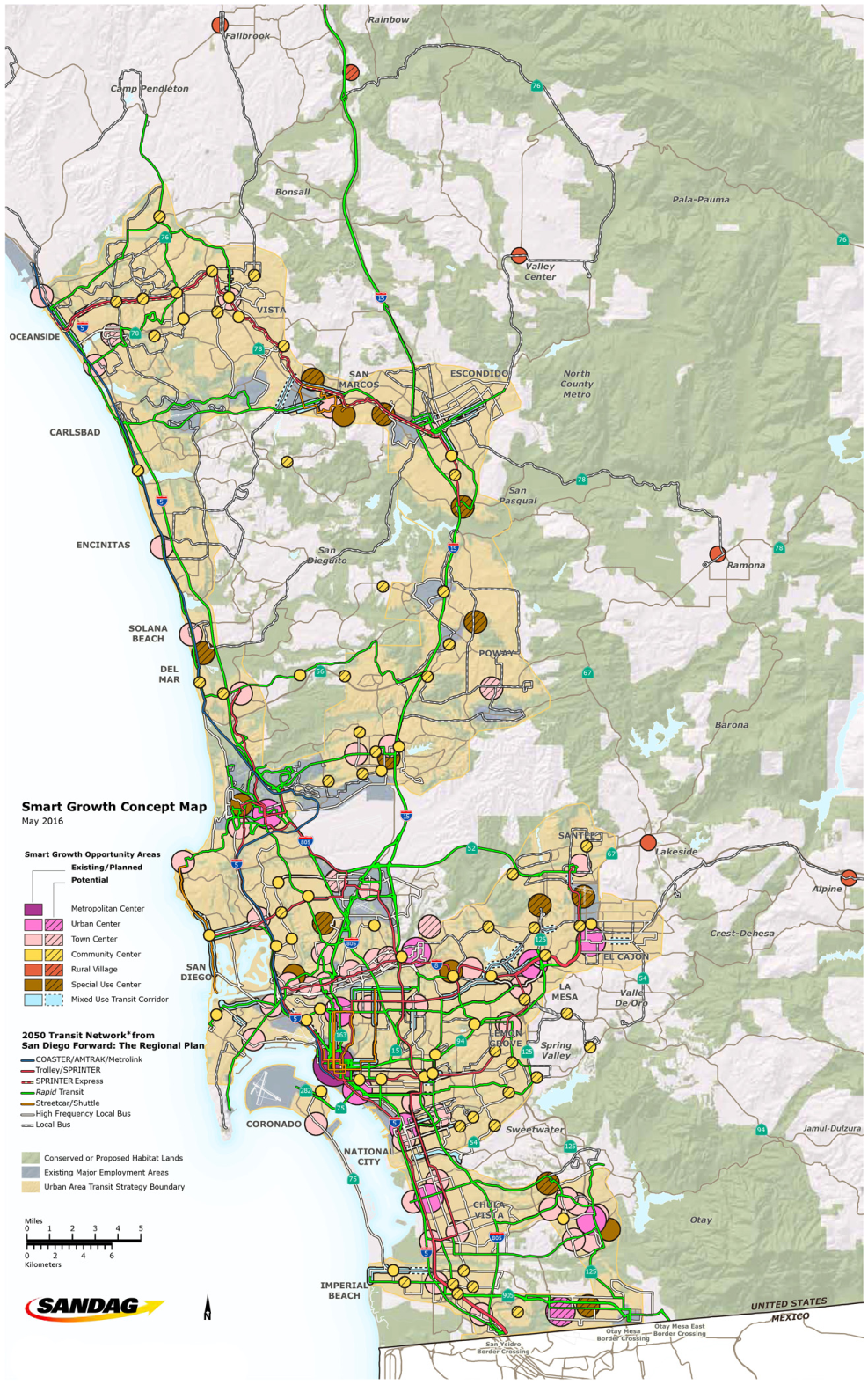
SANDAG Smart Growth Concept Map ( 26 ).
The regional transportation plan establishes land use density and transportation service targets for each of the place types. If the areas on the map meet the targets in current land use and transportation plans, they are identified as “existing/planned” areas and eligible for infrastructure. If they do not, but they exhibit future opportunities for smart growth development, they are identified as “potential” areas eligible for planning grants only. Infrastructure grants can cover streetscape or sidewalk enhancements, transit station improvements, traffic calming measures, or other quality of life amenities that support smart growth in that area. Planning grants can be used to amend general plans, prepare specific plans, or update zoning ordinances which will provide the institutional framework for smart growth development in these areas.
North Central Texas Council of Governments
Dallas-Fort Worth’s MPO, the North Central Texas Council of Governments (NCTCOG), initiated its Sustainable Development Funding Program in 2001. This program was created by the Regional Transportation Council to help address projected population growth, from 6.7 million in 2014 to 10.5 million by 2040, in the 12-county Dallas-Fort Worth Metropolitan Planning Area. It won the Best Award for the “Smart Moves: Transportation Strategies for Smart Growth Competition” from the American Association of State Highway and Transportation Officials (AASHTO) in 2002, a Planning Excellence Award from the American Planning Association in 2009, and Outstanding Overall Achievement Award from the Association of the Metropolitan Planning Organizations.
The program’s goals help NCTCOG add transportation capacity to accommodate the expected growth rate while maintaining a high quality of life. The agency determined that, considering the financial constraints associated with funding new transportation facilities, using only traditional solutions would not work. The Sustainable Development Program aims to support non-traditional, compact developments which can encourage other viable, efficient, and affordable alternative modes of transportation to meet the region’s future mobility needs.
NCTCOG has gone through four funding cycles at the time of writing. To be eligible for Sustainable Development Program funds, projects have to be located in “Sustainable Development Areas of Interest,” that is, within walking distance of current or potential rail stations; in areas with a concentration of unemployed persons, high-emission vehicles, or low-income households; or in historic downtowns with multiple contiguous blocks of pedestrian-oriented development (see Figure 4). Eligible projects are also required to have zoning in place that allows the project to be built by right.
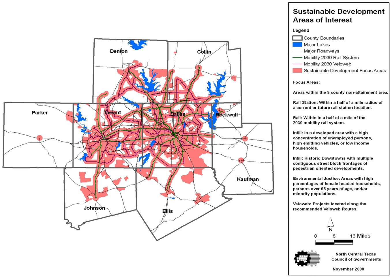
NCTCOG Sustainable Development Areas of Interest.
Under this program, more than $173 million has been awarded since 2001. NCTCOG’s first call for projects funded 19 infrastructure projects and one planning project. The second call in 2005/2006 funded 29 infrastructure, four land-banking, and nine planning projects. The 2009/2010 call for projects funded 27 infrastructure projects and nine planning projects. The 2017/2018 cycle funded six infrastructure projects and a second phase is anticipated at the end of 2018 or early 2019.
National Capital Region Transportation Planning Board
The National Capital Region Transportation Planning Board (TPB) has three major focus areas for transportation and land use coordination: cooperative forecasting, activity centers, and a transportation and land use connections (TLC) program. The TLC program started in 2007 and has three integrated program components: (i) TLC Technical Assistance which provides consultant services to local jurisdictions working on creative, forward-thinking, and sustainable plans and projects; (ii) the federal Transportation Alternatives/Surface Transportation Program Set-Aside, which started in 2012 and allocates reimbursable federal aid for capital improvements considered alternatives to traditional highway construction; and (iii) the Peer Exchange Network (TLC PeerX) which provides opportunities for planners to share and discuss best practices and innovative ideas.
This program has allocated almost $4 million for more than 100 technical assistance projects since 2007 (see Figure 5). In 2018, to the time of writing, TPB approved nine projects totaling $500,000, an increase on the $370,000 awarded for eight projects in 2017.
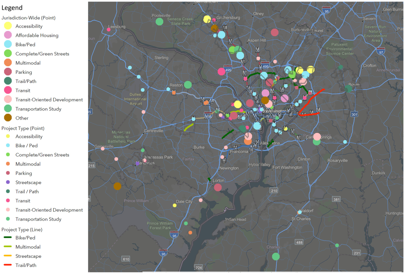
Map of past National Capital Region TPB TLC projects ( 27 ).
The TLC program is designed to help local jurisdictions create vibrant communities by better integrating transportation and land use planning, to support local planning and design projects, and to share success stories and proven tools with governments and agencies across the region. It encourages integrated decision making across disciplines.
In principle, through the TLC program, the TPB helps local jurisdictions address community-level challenges of integrating land use and transportation planning by providing both direct technical assistance and information about best practices and model projects through the TLC Clearinghouse. The TLC projects (and events) are selected based on the criteria of supporting regional policy goals, as stated in Visualize 2045, the Regional Transportation Priorities Plan, cross-jurisdictional collaboration, proximity to activity centers, access to transit, and diversity and equity. The technical assistance includes a range of services, such as:
Corridor and transit station planning;
Design guidelines and roadway standards;
Streetscape improvement plans;
Transit demand and feasibility analysis ( 28 ).
This program is funded by the National Capital Region TPB’s Unified Planning Work Program as well as the Surface Transportation Block Grant Program of the Federal Highway Administration (FHWA). Technical assistance funding ranges from $30,000 to $60,000 for planning and up to $80,000 for design projects. Additionally, the program budget and funding amount vary according to sub-allocation from each state (DC, MD, and VA) for Transportation Alternative Set-Aside. Funding is based on the relative share of the total state population sub-allocated to large urbanized areas. For instance, in fiscal year 2019, funding for DC is $1.19 million, for MD is $1.2 million, and for VA is $5.4 million.
Atlanta Regional Commission
The Livable Centers Initiative (LCI) of the Atlanta Regional Commission (ARC) is one of the longest-running MPO programs supporting local land use planning. The goal of the program is to help residents to “re-envision” their communities as vibrant, walkable places which provide greater mobility options, encourage healthy lifestyles by supporting walking and bicycling, and improve access to jobs and services ( 29 ).
The grant program provides planning funding aims to get cars off the roads by linking residents to shopping, dining, and other activities via sidewalks and bike trails. Since 2000, the program has awarded more than $216 million in grants to more than 119 communities.
LCI grants have funded transit facilities; operations and safety improvements; and investments to make roadways friendlier for bicyclists and pedestrians, including the construction of sidewalks, trails, and other pedestrian and bicycle infrastructure. According to the ARC, the program is helping to encourage active travel and improve air quality in the region. ARC officials credit the LCI with helping to reduce daily vehicle miles traveled in the region by 13% between 2000 and 2017, from 32.1 miles per capita to 28 miles per capita.
The program works by funding local planning efforts that unlock bigger investments in infrastructure and programming to implement a local community’s vision. Since 2000, the LCI has awarded more than $200 million to 120 communities in metropolitan Atlanta (see Figure 6). The program funds policy studies, planning efforts, and project implementation with the goal of helping local governments create “vibrant, walkable places.” For the second stage of the funding process, ARC has budgeted $314 million through 2030 for transportation projects developed as part of LCI plans.
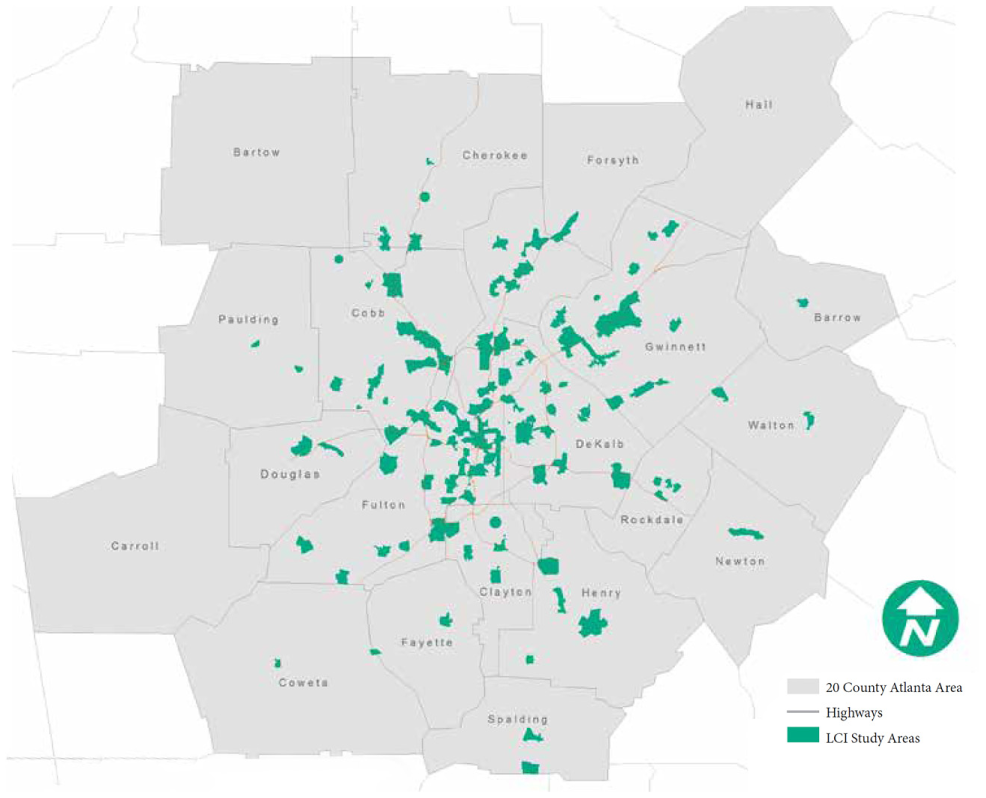
ARC LCI study areas ( 29 ).
The LCI program is funded by federal transportation dollars. Each grant covers 80% of the project, with the recipient contributing a 20% match. The 2018 funding cycle distributed $1 million to 15 communities in metropolitan Atlanta. Grants in 2018 included $120,000 to produce an updated vision and action plan for developing Atlanta’s West End and $30,000 to Gwinnett County for studying the creation of a creek-side trail that improves pedestrian connectivity.
East-West Gateway Council of Governments
East-West Gateway Council of Governments (EWGCOG) launched the St. Louis Great Streets Initiative (GSI) in early 2006. Since then, 15 projects have been completed in six rounds totaling $6.2 million. EWGCOG is currently initiating the seventh round with two more projects, one in Missouri and Illinois each. Figure 7 shows the map of these projects.
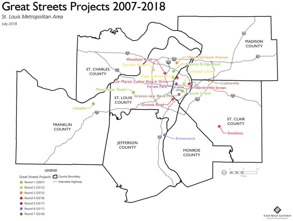
Map of EWGCOG Great Streets Projects ( 30 ).
The program aims to provide technical assistance and prioritize projects which promote lively and attractive streets over those solely focused on high-speed mobility to enhance economic and social benefits and serve all modes of transportation. EWGCOG believes this goal will be achieved by centering communities around these interesting and lively streets. Ten of the first 15 projects produced detailed plans resulting from a lengthy process (nine to 18 months).
The other five projects relied on a broader level planning assistance format, centered on a four day, open door community charrette, which resulted in a concise “Strategic Planning Report.” The goal of this approach is to work with the communities to articulate the significant issues and broader vision of each, stopping short of further detailed analysis. In other words, when it is not possible to conduct a specific analysis, a more general discussion is more appropriate and still includes a range of planning disciplines. These 15 projects were funded through the American Recovery and Reinvestment Act (ARRA), federal transportation planning grants, and local funds provided by the project sponsors.
Whether the deliverable is a detailed plan or a concise strategic planning report, recommendations include a range of tasks, typically including capital improvements, localized land use/development goals, municipal governance adjustments (such as zoning or parking recommendations), special district formation, strategic partnerships, roadway modifications, specific placemaking/wayfinding guidelines, and well-defined subsequent analysis (such as market research, transportation system analysis, utility investigation, preliminary engineering, etc.). Scope, schedule, budget, priorities, phasing, partners, and responsible parties are defined for all plan recommendations.
Funding for detailed plan projects ranges from $300,000 for the Page Avenue/Pagedale project to $1.1 million for the Manchester road project. On the other hand, for strategic planning report projects, the funding amount ranges from almost $30,000 for the route 159/Smithon project to $70,000 for the Gravois/ Affton project. Additionally, EWGCOG offers direct advisory assistance, by request, for communities that are considering or planning specific projects on their own. EWGCOG staff offer help in defining projects and recommending specific scopes of work that complement existing resources, and will share recommended frameworks for effective community engagement.
Project proposals from communities in the St. Louis area demonstrate the five critical eligibility requirements for GSI support ( 31 ): need (activity centers located nearby; good potential for walking and other multi-modal activity), civic support (support of elected officials, local government staff, business groups), area development (supports existing or planned pedestrian-scaled development), physical feasibility, and finally cost effectiveness (demonstrates potential for relatively low cost, yet still effective improvements).
Wasatch Front Regional Council
Wasatch Front Regional Council (WFRC) initially established a smart growth assistance program, Transportation and Land Use Connection (TLC), in 2014 in partnership with Utah’s largest county, Salt Lake County (Office of Regional Development). Since that time, the program has grown to include financial contributions from the Utah DOT and the Utah Transit Authority. There are now ongoing financial contributions from program partners totaling $600,000, matched by $700,000 from WFRC annually. The funds serve projects in the Ogden/Layton and Salt Lake, Utah urbanized areas.
The TLC program provides technical assistance for Wasatch Front communities to engage in planning and visioning. The program has four key goals:
Maximize the value of investment in public infrastructure;
Enhance access to opportunity;
Increase travel options to optimize mobility;
Create communities with opportunities to live, work, and play ( 32 ).
Over the five years of the program’s existence, projects have focused on transit-oriented development, small area planning for town centers, street and active transportation connectivity, and bicycle system planning. Since its inception, nearly $6 million has been invested in local communities. As a part of TLC, WFRC has formed a pre-qualified pool of consultants who are available to be lead consultants for TLC projects. The pool of selected consultants is separated into three categories based on firm expertise, and includes planning, ordinance writing, and market analyses/studies.
The TLC team at WFRC includes three planners who are engaged in administrative tasks and also provide direct planning assistance to a few communities per year. They also handle administrative tasks for communities, utilizing a streamlined letter-of-qualifications process. This reduces the overheads burden on local governments and helps both communities and consultants, which is especially important given the scale of TLC projects, most of which are below $100,000 in total financial resources.
There have been 65 projects funded over the five years of TLC (see Figure 8). Recently, the program helped fund the development of a Commercial Core Plan and implementation plan for the ski resort town of Alta. These plans have allowed Alta to identify transportation and land use improvements while maintaining the town’s historic mining and rural character. They also helped identify a town center and to focus on the creation, enhancement, support, and concentration of commercial development in the base area.
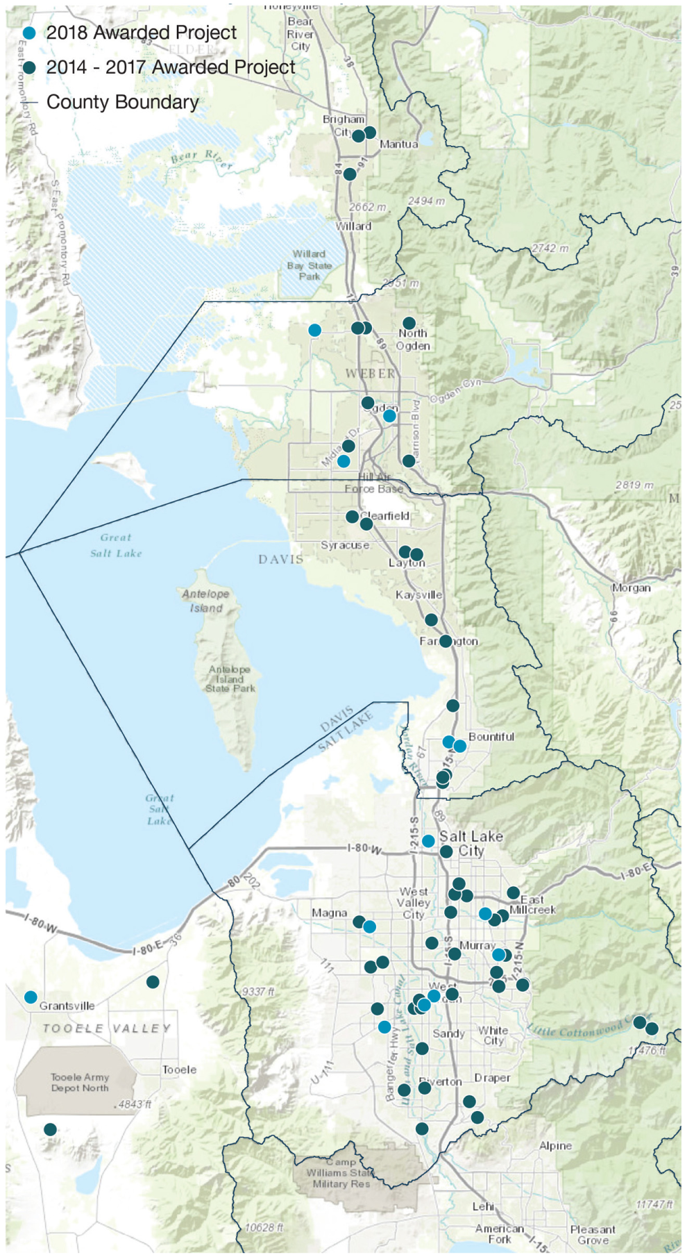
Map of WFRC TLC projects, 2014–2018 ( 32 ).
Memphis Metropolitan Area
The Memphis Urban Area MPO is a bi-state MPO working with the Mississippi and Tennessee DOTs to provide grants which support local land use planning and transportation infrastructure. These Transportation Alternatives Set-Aside programs support everything from active transportation planning to transit enhancements to ADA improvement strategizing. The program was in its sixth year at the time of writing.
Funding for transportation alternatives originated in the Transportation Alternatives Program established in 2012. It is part of the FHWA’s Moving Ahead for Progress in the 21st Century Act, and was carried over in the Fixing America’s Surface Transportation (FAST) Act as the Transportation Alternatives Set-Aside program. The FAST Act replaced the Transportation Alternatives Program with a set-aside of funds under the Surface Transportation Block Grant Program. For administrative purposes, the FHWA will now refer to these funds as the TA Set-Aside.
The program aims to improve or expand physical infrastructure to accommodate or improve access to non-motorized modes of transportation. Programs that have been funded in the past include greenways, shared-use paths, trails, sidewalk improvements, bicycle lanes, transit stop amenities, pedestrian cross, and intersection upgrades, and ADA improvement plans ( 33 ).
Since the program came online, $7.5 million has been awarded to local governments, transit agencies, regional transportation authorities, tribal governments, non-profit organizations, and even school districts. Eligible applicants can apply to either the MPO or Tennessee DOT’s TA Competition through separate application cycles and processes. Available funding for grants has varied from year to year. The Memphis MPO gave a total of $1.3 million to Tennessee and Mississippi jurisdictions in fiscal year (FY) 2018, $2.4 million in FYs 2016 and 2017, $1.3 million in FY 2015, and $2.6 million for FYs 2014 and 2013. For two grant cycles, funding across two fiscal years was given to allow for larger sized grants. As with other MPOs’ programs, providing matching funding is required. Jurisdictions must provide 20% of the total grant awarded. In the program’s first year, at least partial funding was awarded to every jurisdiction which applied.
Two recent examples of funding include the $140,000 grant to the City of Memphis in 2018 for its Great Streets Downtown Corridor Planning and Design project, and the $40,000 grant for the Mullins Station Road Pedestrian Planning and Design project.
One of the biggest benefits of the program thus far is delivering walkable, bikeable, and transit-related efforts to communities across the region. In addition to funding benefits, the regional MPO has been able to establish relationships with local schools, parks, and nonprofit groups.
Capital District Transportation Committee
The Capital District Transportation Committee (CDTC)’s aptly titled Community and Transportation Linkage Planning Program (the Linkage Program) integrates land use and transportation planning to implement the CDTC’s New Visions 2040 regional transportation plan. The program was started as a way to address the challenges faced by local governments attempting to implement the regional plan. The program has been operating in the Albany-Schenectady-Troy and Saratoga Springs region since 2000 and has already been recognized in the U.S. DOT, FHWA, and Federal Transit Administration (FTA) Livability in Transportation Guidebook.
The program’s goals include providing financial and technical assistance to local communities for innovative transportation and land use planning that reflect or implement goals of the regional transportation plan. Since its inception, CDTC has funded 88 studies, totaling approximately $6.3 million in federal, state, and local support ( 34 ). Federal funding for the Linkage Program comes from the Federal Housing Administration (FHA), FTA, and U.S. DOT.
Each local planning effort funded must have an advisory committee with state, regional, and local representatives, which commonly include elected officials, planning board members, business owners, residents, local institutions, and nonprofit organizations. To be eligible for an award, grant recipients must provide a 25% local match contribution of the total cost. Furthermore, each project must have two interactive public workshops. CDTC believes it has been successful because it is one of the most significant cooperative efforts in the nation
Funding and assistance have supported a variety of planning efforts including corridor studies, transit feasibility studies, small-area sector studies, strategic zoning code changes/zoning code overlays, and strategic master plans. Recent grants include $90,000 to the City of Albany to develop a complete streets policy and a design manual meant to complement the city’s existing Comprehensive Plan, Bicycle Master Plan, and Complete Streets Ordinance. Another $40,000 grant was given to the town of Malta to undergo a feasibility study reconfiguring Route 9 with a complete street design.
Discussion and Conclusion
While the amount of funding and support provided by MPOs differs greatly by region and each region has unique geographic and contextual factors which affect its ability to coordinate transportation and land use, the ultimate goal of these programs is similar: reduce the amount of suburban sprawl and associated need for highway building and instead create more livable, sustainable, walkable, bikeable, and transit accessible communities. From the information gathered, these programs seem to provide a unique and effective opportunity for MPOs to build relationships with local officials, staff, and the public to support greater transportation and land use integration.
By reviewing the programs of 10 MPOs, these comparative case studies find that TLC programs have grown regularly for the majority of MPOs. In a few instances funding for grants has varied year by year. In general, grants are small relative to the MPO’s overall budget, and local municipalities need to compete for these grants. These agencies draw on a variety of funding sources to finance their TLC programs, depending upon whether their efforts involve planning, project implementation, or both. However, the bulk of funding tends to come from federal budgets.
MPOs use different approaches and criteria to evaluate, prioritize, and select planning efforts to receive funding. Typically, projects are eligible for funding if they align with the region’s transportation plan (e.g., GO TO 2040 for CMAP, Plan Bay Area 2040 for San Francisco Bay region’s MPO, and New Visions 2040 for CDTC). Projects that promote access to increased opportunities, demonstrate collaboration across multiple jurisdictions, leverage economic and social benefits, and serve multiple, especially active, modes of transportation, also get funding priority. Some MPOs will only support projects that fall into a priority or opportunity area (e.g., Smart Growth Opportunity Areas for SANDAG and Sustainable Development Areas of Interest for North Central Texas). It is worth mentioning that for some MPOs, like ARC, communities that complete TLC plans become eligible for further infrastructure funding.
The TLC programs fund a range of project types including planning grants, infrastructure projects, and technical assistance to local governments. Some MPOs fund only one project type (e.g., technical assistance), while others fund multiple types (e.g., plans, project implementation, policy studies, infrastructure, and technical assistance). The latter tend to devote a lot more financial resources to their programs than do the former. This too can be considered an exemplary practice since, even in extreme cases, a TLC represents a small proportion of overall MPO funding.
Another interesting point about these programs is that many of them encourage infill or development around centers. The grants provided by these MPOs are used to develop high density mixed-use centers (with different names), especially ones located along existing or potential transit corridors. For instance, the San Francisco Bay region’s MPO provides grants for “priority development areas,” SANDAG does the same, but calls it “potential and existing smart growth opportunity areas.” The promotion of infill and redevelopment via dense mixed-use centers is another exemplary practice.
Access to transit is another important factor for assessing eligibility for funding. In principle, by concentrating development around mixed use, and areas of high residential and employment density, regions are attempting to improve the viability of transit corridors to create vibrant and walkable environments with a mix of services and amenities. These centers can help to reduce vehicle miles traveled by promoting transit use and local trips for services.
This study is subject to some limitations. It is just the first step in understanding this type MPO funding better. The first limitation is the small sample of MPOs studied, particularly the lack of MPOs serving smaller metropolitan areas. Phase 2 of the research has already begun, which expands upon this study to discover whether other small and medium-size MPOs have these kinds of programs. A second paper with findings from a survey sent out to all 404 MPOs is in preparation, which will detail program outcomes, including their successes and challenges. The second limitation relates to the aggregate nature of the data. This study has mostly aggregate data on funding, project totals and types, years of operation, and so forth, but no data as yet on the projects themselves (except a few of them). A follow up series of case studies will drill down to the project and municipal levels to understand better exactly what is being funded. Related to this is a limitation on the coverage of the case studies. For example, it has yet to be ascertained what shares of MPO budgets are devoted to these grants programs, but it is likely the shares are small. Related to coverage, this study focused on inputs to these programs, such as number of projects funded by type. The research team has virtually no information at this point on outputs and outcomes. These programs fund main street planning studies and, in some cases, streetscaping projects, but what impact this has on quality of life factors is unclear. Getting answers to such questions will require a different kind of study than this one.
Nonetheless, this study has identified an important trend in metropolitan governance which has received very little attention. The authors invite others to join them in learning about this trend and its consequences.
Footnotes
Acknowledgements
The authors thank all the planners and program managers at the 10 MPOs for reviewing, revising, and updating the information provided in the “case studies” section.
Author Contributions
The authors confirm contributions to the paper as follows: study conception and design: SS, AD, RE, MT; literature review: SS, AD, DP; data collection: SS, AD, DP, MT, RE; analysis and interpretation of results: SS, RE, AD; draft manuscript preparation: SS, AD, DP, RE. All authors reviewed the results and approved the final version of the manuscript.
The Standing Committee on Metropolitan Policy, Planning, and Processes (ADA20) peer-reviewed this paper (19-05991).