
Abstract
With the infusion of emerging technologies into highway construction practices, state departments of transportation (DOTs) can make better informed decisions that positively influence cost, schedule, quality, and safety. DOTs are increasingly using instrumentation and sensor technologies for delivering highway projects across the U.S.A. Instrumentation devices and sensors include such technologies as remote sensing, real-time kinematics, global positioning systems, digital handheld devices, ground penetrating radar, and intelligent compaction/thermal profiling. These technologies are becoming commonplace in highway construction because of their capabilities to improve the construction process by making activities more efficient and more productive. However, the practices in using instrumentation and sensor technologies for highway construction vary among state DOTs. Therefore, this study investigates how DOTs employ the use of instrumentation and sensor technologies for highway construction. This study engaged a research methodology that included an extensive literature review, survey questionnaire, and case studies of state DOTs. Results show that 31 state DOTs use instrumentation and sensor technologies for monitoring work progress, conducting quality control and quality assurance, performing construction inspections, identifying optimal conditions and recording the placement of work, and locating utilities. The main barriers to using instrumentation and sensor technologies include analyzing the large amount of data, verifying the accuracy of the data, ensuring staff have the skills and knowledge to use the technologies efficiently, and assisting smaller contractors to gain the knowledge to use these technologies. The findings from this study provide recommendations and strategies for DOTs to implement instrumentation and sensor technologies effectively for highway construction.
The highway construction sector uses technologies that add value to construction processes by making specific construction activities and tasks more efficient. The use of instrumentation and sensor technologies is one area of technologies that can provide cost, schedule, quality, and safety efficiencies for highway construction projects. These technologies, which include instrumentation devices such as handheld real-time kinematic and ground penetrating radar devices, and sensor equipment, such as infrared and thermal sensors, monitor and collect data for specific components of highway construction projects. In particular, state departments of transportation (DOTs) and their contractors are increasingly using instrumentation and sensor technologies for construction activities. Instrumentation devices and sensors include such technologies as remote sensing, real-time kinematic global positioning systems (GPS), intelligent compaction and thermal profiling, audio/video and closed-circuit television (CCTV), and environmental and air quality sensors. DOTs use these instrumentation and sensor technologies to perform tasks such as construction inspections, quality assurance/quality control (QA/QC), evaluating structural forces and conditions, monitoring environmental conditions, monitoring placement of work, identifying optimal conditions for placement of work, and recording progress of work ( 1 ).
As technologies become more commonplace in highway construction, DOTs will continue to increase the use of instrumentation and sensor technologies for construction delivery. Recently, researchers have been investigating instrumentation devices and sensors, and their applications to construction. However, the implementation and application of these technologies by state DOTs specifically for highway construction delivery has been explored on a limited basis. Therefore, the objective of this study is to investigate the challenges to implementation and use, and the benefits of instrumentation and sensor technologies for delivering highway construction projects to provide information for public highway agencies to implement instrumentation and sensor technologies strategically in highway construction.
Background
Instrumentation devices and sensors have been used in the construction industry to measure motion, position, location, and environmental conditions, and to identify and monitor people (e.g., construction workers), equipment, tools, vehicles, and materials ( 1 ). The following sections discuss typical instrumentation and sensor technologies used in highway construction, including remote sensing, real-time kinematic (RTK) GPS devices, ground penetrating radar, and intelligent compaction and thermal profiling.
Remote Sensing
Remote sensing is a data collection tool that uses instrumentation and sensor technologies to collect information about objects without coming into contact with the objects by using satellite imagery, aerial photography, radar, light detection and ranging (LiDAR), sonar, and other sensory and visualization techniques (
2
). Remote sensing for highway construction offers DOTs non-destructive methods that differ from traditional in-situ methods for assessing various highway assets and activities under construction (
3
). Many different remote sensing technologies exist today, such as three-dimensional optics (e.g., photogrammetry), high-resolution street view style digital photography, optical interferometry, spectral analysis, digital image correlation, electro-optical satellite and airborne imagery, LiDAR, infrared thermography, interferometric synthetic aperture radar (InSAR), and remote acoustics (
4
). The common applications of remote sensing to construction, as stated by Schnebele et al. (
3
), Vaghefi et al. (
4
), and Carlson et al. (
5
), include:
Mapping construction site topography using LiDAR; Construction site surveying using RTK, LiDAR, and photogrammetry; Monitoring progress of work using high-resolution aerial imagery and photogrammetry; Measuring quantities of earthwork materials for cut and fill using LiDAR, aerial imagery, and photogrammetry; Verifying the placement of roadway materials using infrared thermography and intelligent compaction; Monitoring structural integrity and displacement in the construction of bridges and structures using digital sensors and high-resolution aerial imagery; and Time-lapse imagery and videos using high-resolution audio/video equipment and closed-circuit television for accelerated bridge construction projects.
RTK Systems
RTK is a system used for correcting systematic errors in GPS positioning to enhance the precise position of collected data and involves a reference receiver transmitting its measurements and observation corrections to a rover receiver via a data communication link such as ultra-high frequency radio or cellular telephone (
6
). An RTK system typically consists of a base station (or multiple base stations in a network), one or more handheld rover units, and a data transfer link between the base station and the rover units. The use of RTK systems has been shown to improve the accuracy, reliability, integrity, productivity, and capacity of GPS devices and related applications (
7
). Other applications for RTK include site surveying, collecting highway assets and as-built information, and checking the precise placement of work, slope, and elevation of grading (
8
). The National Cooperative Highway Research Program (NCHRP) Synthesis 372 (9) listed benefits of using RTK GPS-enabled devices compared with conventional survey practices:
Construction surveying: faster surveying and mapping for design; eliminating the need for iterative staking of project phases; Constructability reviews: providing effective tools for reviews throughout the design and construction phases, which helps reduce errors and omissions; less time required to perform reviews; Earthwork operations: allowing for the most efficient operation of earthwork equipment; greater accuracy of finish grading requirements; labor and equipment resource savings; As-builts and inspections: improved as-built and QA/QC documentation.
Ground Penetrating Radar
Ground penetrating radar (GPR) is a non-invasive sensing technique that has increased in use because of its flexibility and potential for accurately capturing images of subsurface structures and materials. GPR infiltrates the surface level using transmitter antennas that radiate electromagnetic waves into the subsurface, which reflect off subsurface objects (e.g., utilities, structure foundations, rebar in pavements) and back to GPR devices that then measure the amplitude and arrival time of electromagnetic waves ( 5 ). When electromagnetic waves hit an object, the electrical properties differ from the surrounding medium, which will result in different reflection waveforms. By performing data analysis of the reflection signals, the subsurface structural features can be characterized ( 10 ). GPR has a wide range of applications in highway construction, such as locating underground utilities, unexploded land mines, caves, tunnels, or other unseen objects without excavation or destruction. Figure 1 shows the applications of GPR and the resulting benefits in construction delivery ( 11 ).
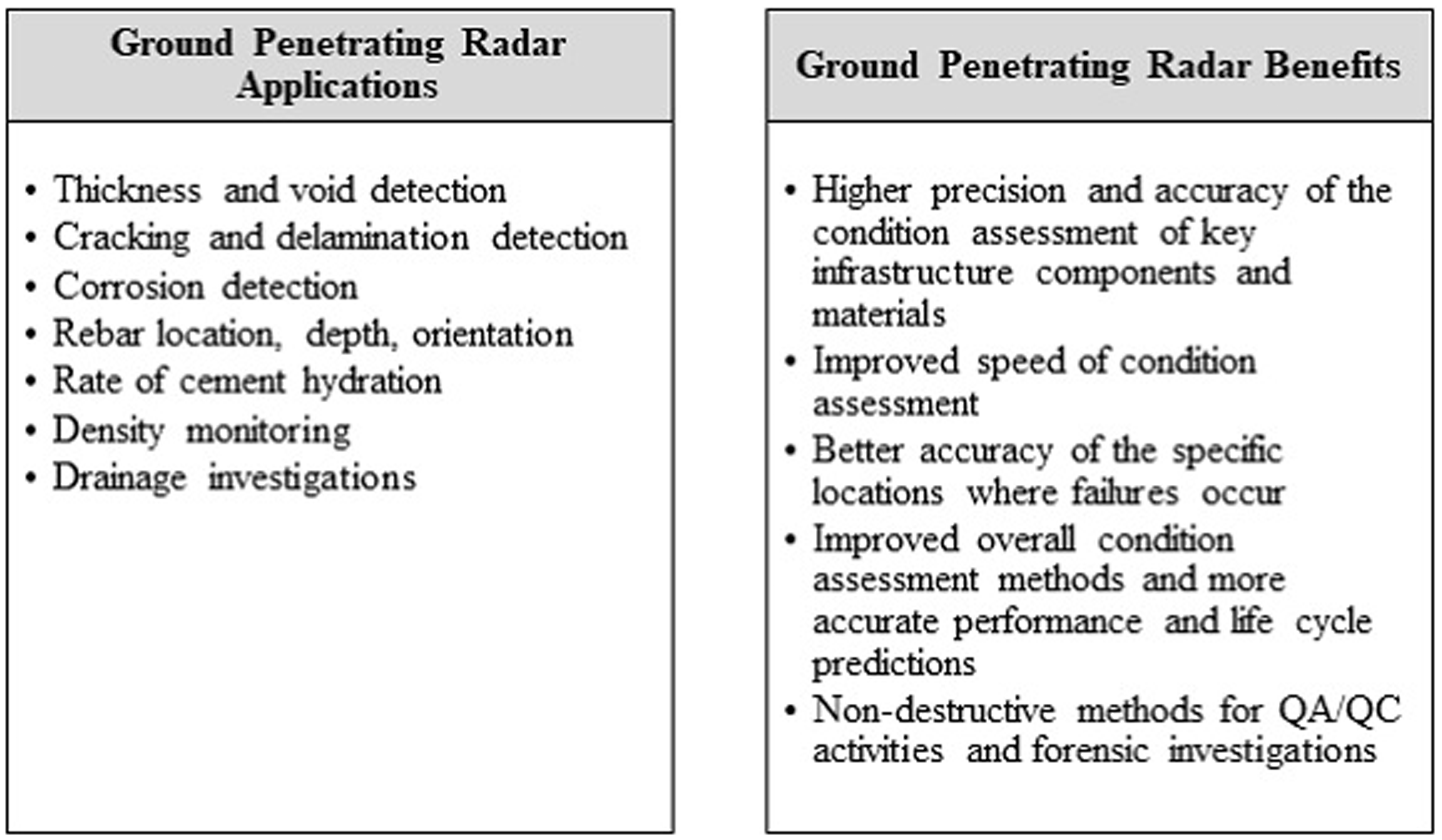
Applications and benefits of using ground penetrating radar for highway construction (11).Note: QA/QC = quality assurance/quality control.
Intelligent Compaction and Thermal Profiling
Intelligent compaction (IC) is a technology tool for compacting roadway materials, including soils, aggregates, and asphalt pavement. IC uses vibratory roller pavers equipped with an accelerometer-based measurement system, GPS, and an onboard display for monitoring and controlling compaction ( 12 ). The use of IC technologies integrates measurements, documentation, and controls to allow for real-time tracking of roller passes and roller speed, measuring the surface temperature of the pavement material as it is being placed, and adjusting the frequency of the vibrations used to pave. The accelerometer system provides an IC measurement value (ICMV), which is a measure of stiffness for the placed and compacted materials ( 13 ). IC has the capabilities to provide more uniform material compaction, and improved operational efficiency as it reduces the number of passes needed. IC also assists DOTs with QC/QA as it records the ICMV stiffness values along the entire roadway being paved ( 12 ). However, it is important to note that using IC for asphalt paving operations may not provide proper measurements of pavement density, as studies have shown high variability in the quality of the correlations between ICMV values and measuring the density of asphalt pavement with traditional means ( 14 ).
Paver mounted thermal profiling (PMTP) for paving operations is used to monitor asphalt surface temperatures, as well as paver speed, number of stops, and stop durations. PMTP uses a measurement system with thermal scanners and cameras attached to a paver to monitor continuously the surface temperature of the asphalt paving material immediately behind the paver screed ( 15 ). The benefits in using both IC and PMTP together allows for real-time compaction control and monitoring and provides information for making any needed adjustments. This process allows operators to monitor and review the uniformity and consistency of the paving material laydown temperature ( 13 ). Laydown temperature is important to paving as high temperature differentials between the paved layers results in lower pavement density, which can reduce the pavement life span ( 16 ).
Methodology
The objective of this study is to examine the implementation and use of instrumentation and sensor technologies by state DOTs for highway construction delivery and provide the findings to state DOTs on how they can implement these technologies strategically. To achieve the objective, this study employed a multiple-prong research methodology using three primary research tasks. The authors conducted a literature review to collect information on the types and uses of instrumentation and sensor technologies as they pertain to highway construction projects. Using the collected information in the literature review, the authors developed and distributed a survey questionnaire to DOTs to collect current practices across the U.S.A. on these technologies. Finally, the authors selected six DOTs as the basis for conducting case studies on the uses, benefits, challenges, and lessons learned in implementing instrumentation and sensor technologies for highway construction.
Literature Review
The authors conducted a comprehensive literature review exploring instrumentation and sensor technologies. The authors searched academic literature, construction industry publications, websites of state DOTs and other public transportation agencies, and federal government reports to find the current types and applications of instrumentation and sensor technologies. Specifically, information was collected on the types, uses, and benefits of, and challenges to, the implementation of instrumentation and sensor technologies in highway construction delivery. To collect relevant literature, the authors used the following search tools and databases:
Transportation Research Information Database; Transportation Research Record archive and the proceedings from the TRB Annual Meetings; American Society of Civil Engineers (ASCE) libraries; Construction and civil engineering journals; Federal Highway Administration (FHWA) research library; and Internet search tools such as Google Scholar.
Survey of DOTs
From the information collected in the literature review, the authors developed a questionnaire to survey DOTs. The purpose of the survey was to gather information on DOT practices and uses of instrumentation and sensor technologies and to identify DOTs with knowledge and experience of these types of technologies that would warrant additional investigation as case studies. Further, the questionnaire allowed DOT respondents to attach relevant documents, or reference specific websites that pertain to instrumentation and sensor technologies used by DOTs. The survey questions inquired about: (i) the types of highway projects that benefit from using instrumentation and sensor technologies; (ii) what instrumentation and sensor technologies the DOT has used for highway construction and how are they used; (iii) the frequency of use and the stakeholders using these technologies; and (iv) challenges and lessons learned in using instrumentation devices and sensor technologies.
The authors distributed the survey questionnaire via email to the American Association of State Highway and Transportation Officials (AASHTO) Committee on Construction, which includes members from all 50 state DOTs. The authors asked that the contacted AASHTO Committee on Construction member either complete the survey or forward it to other staff best qualified to respond to the survey. The objective of the survey distribution was to collect superlative responses from each DOT. After sending reminder requests, via email and phone calls, 41 completed questionnaires were obtained out of 50 DOTs, an 82% response rate. Out of the 41 DOT responses, 31 were implementing, four were considering implementation, and six were not currently implementing instrumentation or sensor technologies in highway construction operations.
Case Studies
The data collected from the survey questionnaire were used to draw conclusions on implementation and challenges in using instrumentation devices and sensor technologies in highway construction, and to identify DOTs for the case studies. The authors then conducted six in-depth case studies to gather specific information on the use of instrumentation devices and sensor technologies during construction delivery.
Selection of Case Studies
Data from the survey questionnaire and literature review were used to select the DOTs for the case studies. The authors qualified DOTs by analyzing their experience, comprehensiveness, and availability of instrumentation and sensor technologies documents and data; and the willingness of DOT staff to participate. Participation involved conducting interviews with DOT staff that use or manage the use of instrumentation devices and sensors, collecting related documents and reports, and reviewing the findings. The following case study protocol was used:
Contact DOT representatives to orient the authors to the DOT, and request access to and participation of staff knowledgeable about instrumentation and sensor technologies. Perform interviews with DOT staff to identify the uses, benefits, challenges, and lessons learned of using instrumentation and sensor technologies for construction. Collect DOT documents and reports related to the technology. Follow up with the DOT representatives interviewed to verify the collected findings.
To develop the case study questions, the authors used Oppenheim ( 17 ) as a research guide. The case studies were performed using the protocol outline above and in accordance with the Government Accountability Office (GAO) procedures (18). The six DOTs that agreed to participate in the case studies were: Minnesota, New York State, Ohio, Pennsylvania, Utah, and Wisconsin.
Minnesota DOT
Minnesota DOT uses various instrumentation and sensor technologies. Audio/video and CCTV are used to monitor work progress and site security. Remote sensing helps Minnesota DOT identify optimal work conditions and in documenting as-built information. Sensor technologies are employed for monitoring structural integrity, environmental conditions, and measuring specifications, which are used for QA/QC purposes as well as construction inspections.
Minnesota DOT leads a pooled-fund study (TPF-5[534]) that developed the software program called Veta, which is a standardized intelligent construction data management system. Veta, a non-proprietary software, uses IC and thermal profiling to map, edit, and analyze geospatial data, material performance, project specifications, and compaction curves based on the equipment-rolling pattern. Although Veta does not provide real-time mapping and does not provide data on live compaction activities, it helps to analyze the massive amounts of data collected by the IC and thermal profiling devices.
New York State DOT
New York State DOT implements remote sensing and various sensor devices to assist with evaluating structural members, verifying placement of work, QA/QC, and construction inspections. A primary driver in the implementation and use of various instrumentation and sensor technologies is a lack of staff to perform construction tasks in a traditional manner, which affects the cost and schedule outcomes of projects. New York State DOT has a limited number of survey coordinators and each year they have too many maintenance and construction projects for the number of survey coordinators available. Therefore, the DOT trained construction inspectors to use GPS and 3D models in the field to measure specifications and quantities. The inspectors in the field were then provided with handheld RTK devices, which allowed them to collect the information needed for inspection purposes.
Ohio DOT
In Ohio, the traveling public and the state legislature constantly ask for faster delivery of large and complex highway projects. Therefore, Ohio DOT realized that using technologies has the potential to make their construction delivery more efficient. Current practices at Ohio DOT include remote sensing, sensors for measuring specifications, and sensors for monitoring environmental conditions, which Ohio DOT uses to perform construction inspections, locate utilities, monitor progress of work and placement of work, and QA/QC. Instrumentation technologies encourage Ohio DOT and its contractors to use more accurate and less invasive methods, allowing for better measurements of specifications and project performance measures. Ohio DOT has run several demonstration projects for different instrumentation technologies, including thermal profiling, measuring environmental conditions, density measures, radiographic weld checking, and infrared sensors to measure the placement of rebar in a structure. Using these technologies provides better measurements for QA/QC purposes and enables accurate and non-destructive inspections.
Pennsylvania DOT
Pennsylvania DOT focuses on the ability of technologies to solve a known issue and to improve the efficiency of construction tasks. Pennsylvania DOT employs various instrumentation and sensor technologies, including audio/video and CCTV, remoting sensing, and sensors for measuring specifications. The use of these technologies helps the DOT to record the placement of work, identify optimal working conditions, and conduct quality control/quality assurance and construction inspections. As an example of use, Pennsylvania DOT distributed handheld weather sensor devices to field personnel to collect climatic conditions for bridge deck concrete pouring activities. The handheld weather stations measure the humidity level and wind speed to ensure proper ranges of humidity and wind before placing materials. The sensor device helps determine the evaporation rate of the concrete mix so that field workers know if they can appropriately place the deck and cover it up without compromising the surface integrity of the pavement.
Utah DOT
Utah DOT uses audio/video and CCTV at project sites to document the progress of work and monitor construction sites. Further, Utah DOT uses remote sensing, sensors, RTK, and GPR devices to locate utilities, verify design during construction, and to measure the placement of work for comparison with the project specifications. Also, Utah DOT has piloted the application of sensors on construction equipment to measure environmental conditions during placement of work. For example, Utah DOT and their contractors are now using sensors to measure the temperature at the rear of a paving machine (PMTP) and then use tracking sensors to monitor the roller and track the compaction (IC).
Wisconsin DOT
Wisconsin DOT continuously searches for ways to provide better products and services, which means that technologies play an important role in highway construction delivery. Wisconsin DOT uses remote sensing and various sensors to monitor progress of work, locating utilities, and performing inspections. Instrumentation and sensor technologies assist the construction inspection process as inspectors use handheld rover devices that can read and record quantities and specifications quickly and accurately. The handheld devices use LiDAR and GPS with RTK that is similar to light-grade surveying equipment. By providing inspectors with handheld technology devices that measure the placement of work, fewer inspectors are needed for the construction inspection process. Additionally, inspectors no longer need to carry tape measures and other tools to do the same inspections.
Findings and Discussion
Using the information and data collected in the literature review, survey questionnaire, and case studies of six DOTs, the authors evaluated the collected data to identify the types and uses of instrumentation and sensor technologies for highway construction delivery. In addition, the evaluation investigated the challenges and benefits in using instrumentation and sensor technologies, which helped to develop recommendations and strategies for state DOTs and other public transportation agencies to consider for successfully implementing instrumentation and sensor technologies into highway construction activities.
Use of Instrumentation and Sensor Technologies
Thirty-one DOTs are implementing instrumentation and sensor technologies, four DOTs indicated they are considering implementation, and six DOTs are not implementing them. Figure 2 illustrates the types of instrumentation and sensor technologies that DOTs are using or considering using for highway construction. Of the responding DOTs, 23 (66%) implement remote sensing technologies, 20 (57%) implement sensors for measuring and monitoring structural integrity (e.g., sensors and gauges for stress, strain, deformation, seismic/vibration, and current/voltage, temperature, humidity, etc.), and 19 (54%) implement audio/video and CCTV for highway construction projects.
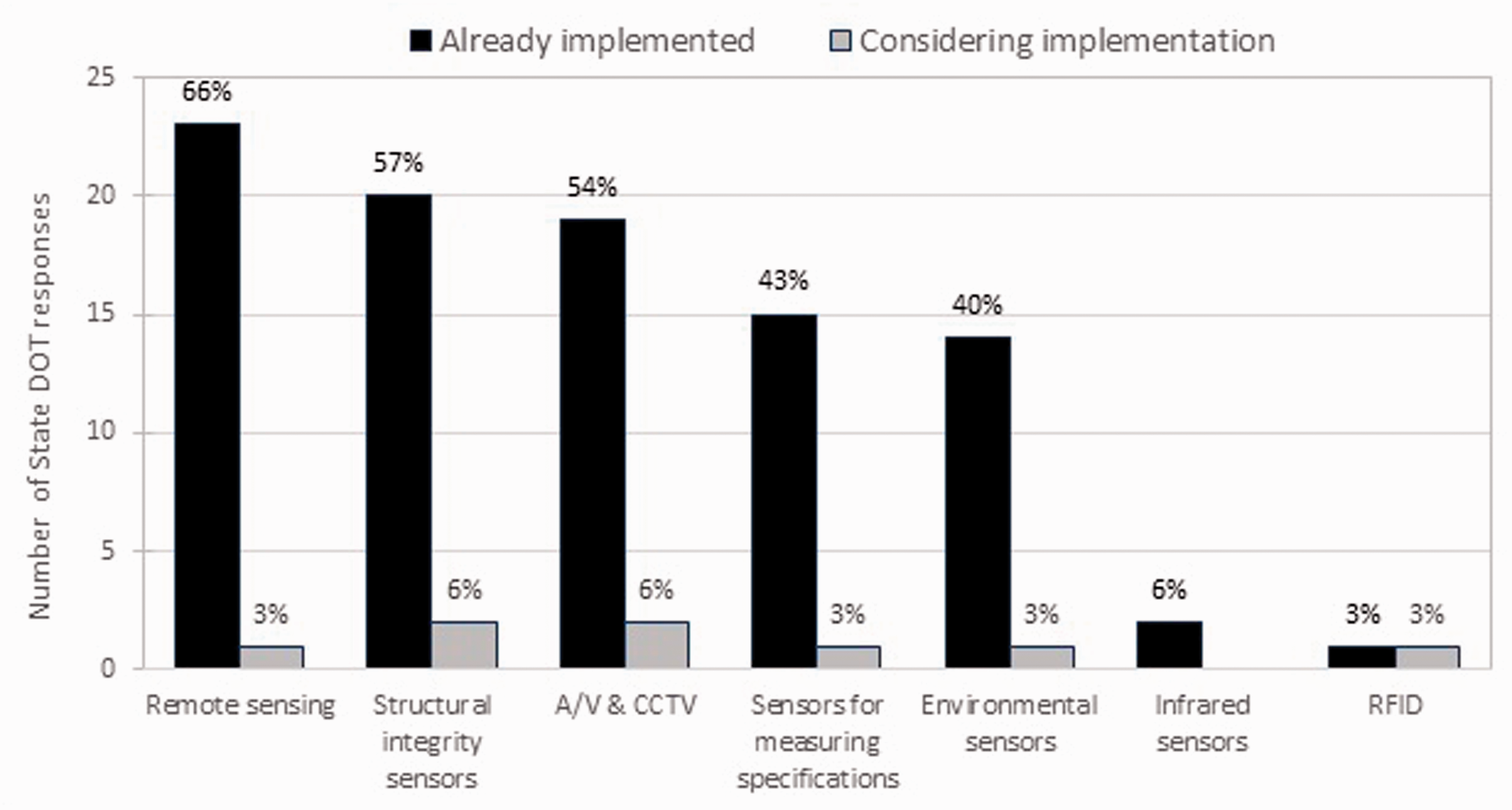
Instrumentation and sensor technologies implemented by state DOTs.Note: DOTs = departments of transportations; A/V & CCTV = audio/video and closed-circuit television; RFID = radio-frequency identification.
Table 1 provides a summary of the 31 DOTs that reported they are currently using instrumentation and sensor technologies for construction activities. Instrumentation and sensor technologies are primarily used for monitoring the progress of work, QA/QC, construction inspections, and identifying optimal conditions for placement of work. Wyoming DOT uses settlement instrumentation for projects involving significant earthwork fill. Oklahoma DOT uses remoting sensing for identifying the placement of large embankments and bridges. Washington State DOT uses environmental air quality sensors for projects that may experience air quality issues, and audio detection devices for measuring audio levels and warning workers when certain hearing thresholds are exceeded ( 1 ).
Reported Uses of Instrumentation and Sensor Technologies
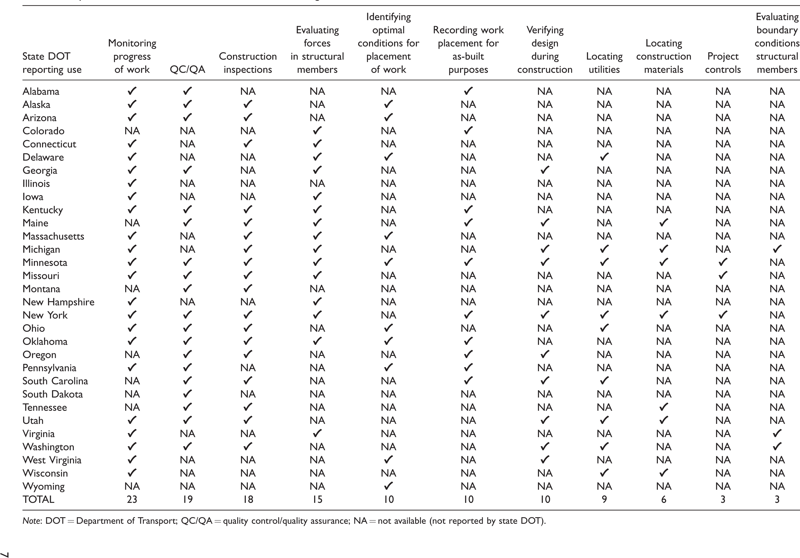
Note: DOT = Department of Transport; QC/QA = quality control/quality assurance; NA = not available (not reported by state DOT).
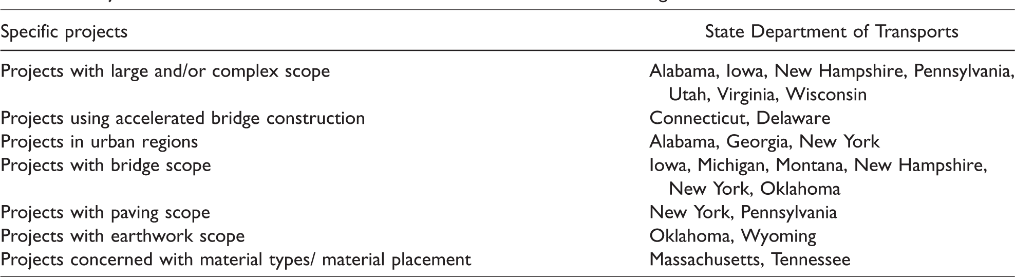
Table 2 summarizes the use of instrumentation and sensor technologies associated with different types of projects. Alaska, Arizona, Kentucky, South Carolina, and Washington DOTs reported that they tend to use instrumentation and sensor technologies on all construction projects, regardless of scope and complexity. Alabama DOT indicated that they use instrumentation and sensor technologies for projects located in metropolitan areas, while Virginia DOT uses these technologies for projects that involve monitoring and evaluating the integrity of forces within complex bridges and structures. Oklahoma DOT employs instrumentation and sensors for projects that include large embankments and bridge construction. New York State DOT implements instrumentation and sensor technologies for projects involving large paving scope, while the Connecticut and Delaware DOTs employ these technologies for accelerated bridge construction projects.
Project Characteristics Suitable for Instrumentation and Sensor Technologies
Use by Stakeholders and Project Types
In relation to the direct use of instrumentation and sensor technologies, the DOTs, contractors, and subcontractors use these technologies for highway construction projects. Most of the DOT responses to the survey noted that contractors and subcontractors use sensors to measure performance and placement of work for quality control and project control purposes. The DOTs tend to use instrumentation devices and sensors for testing and monitoring by measuring performance, verifying work, and conducting construction inspections in the field.
Additionally, state DOTs were asked what types of work benefit from the use of instrumentation and sensor technologies. Figure 3 shows that 28 DOTs mentioned that bridge construction work benefits from the use of instrumentation and sensors, while 19 DOTs indicated that these technologies benefit paving work. Missouri and New Hampshire DOTs stated that instrumentation and sensors are used for large bridge projects with complex foundations and full-depth concrete decks. Other work types that benefit from using instrumentation and sensor technologies include structures beside bridges, earthwork and grading, utilities, and drainage. Oklahoma DOT uses instrumentation devices and sensors for embankments and slope stabilization work, while Minnesota DOT uses GPR for locating underground utilities.
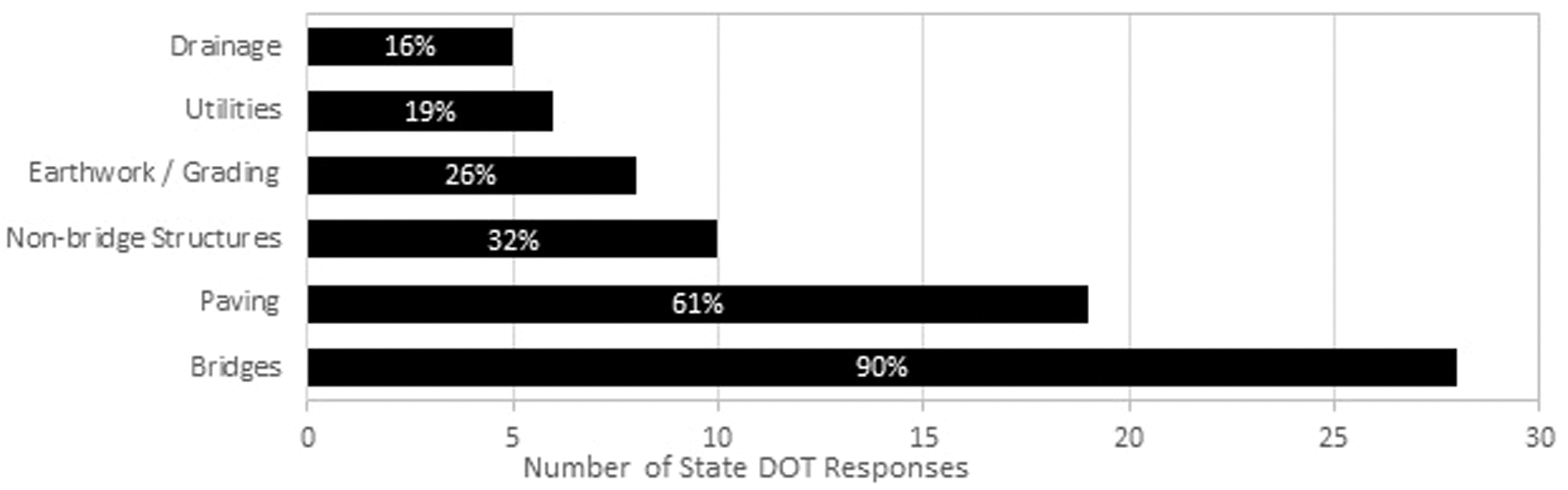
Types of work benefiting from instrumentation and sensor technologies.Note: DOT = department of transportation.
Challenges in using Instrumentation and Sensor Technologies
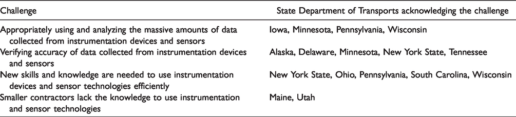
Implementing instrumentation and sensor technologies allows DOTs to perform construction activities more efficiently, which helps to improve the productivity and performance of a highway construction project. However, implementing the use of instrumentation and sensor technologies comes with many challenges that DOTs must overcome so they can adopt and regularly use them. Table 3 summarizes key challenges in the implementation of instrumentation and sensor technologies based on analysis of the survey responses. The major concerns that DOTs noted involve dealing with the amount and accuracy of the collected data that comes from instrumentation devices and sensors used in the field.
Challenges in Using Instrumentation and Sensor Technologies
Analyzing Large Amounts of Collected Data
The use of instrumentation and sensor technologies provides for the collection of detailed information for various construction activities. A construction project that employs many different instrumentation and sensor technologies will generate enormous amounts of data since these devices and sensors are typically designed to collect data on a continuous basis. By collecting more detailed data during the performance of a construction activity, DOTs can make better and more informed decisions. The difficulty lies in knowing what data should be used and how should it be analyzed. Iowa DOT stated that additional data from instrumentation is beneficial for monitoring structural loads, verifying design conditions, and monitoring structural health. However, Iowa DOT staff have struggled with finding and using the “right” data from the vast amounts of digital data that devices and sensors collect. Similarity, Wisconsin DOT noted that the data from instrumentation comes in large quantities and collecting the data is the easy part, while processing, storing, and sharing the data is the challenge. Pennsylvania DOT collects data from construction activities with the use of sensors and handheld devices, but experiences the problem that not all the data collected is needed or usable for analyses, and staff are unsure what is the proper data to use or what analyses to use with the data. Determining data that is important and usable is an area of much discussion by state DOTs and requires further research investigation.
Verifying Accuracy of Collected Data
The accuracy of the collected data can come into question if proper steps are not taken in operating and maintaining digital instrumentation devices and sensors. New York State DOT reported having experienced disputes on highway construction projects because of discrepancies between the DOT and the contractor on the control points and original ground truth of existing terrain. In one such dispute, the DOT asked the contractor to establish the original ground truth for the construction of a new section of roadway. However, during the verification process, which is typically a part of the contractual control plan, the contractor established the ground truth incorrectly, which meant the control points were also incorrect and that made quantity calculations inaccurate. This caused rectification work on the project, ultimately costing more money and taking more time. Alaska DOT reported similar experiences to the New York State DOT and expressed that it is important to double-check all collected data for accuracy. Georgia DOT examined the accuracy of data coming from instrumentation and sensor technologies and found that redundancy in the use of multiple devices and sensors helps to improve the accuracy of data collection. However, multiple devices mean that a significant amount of data are being collected, which the Georgia DOT mentioned is more difficult to analyze. It is also necessary to consider the maintenance and calibration of instrumentation devices and sensors. As Tennessee DOT pointed out, the lack of, or improper, maintenance of technological devices, and not correctly calibrating them, leads to missing data or collection of inaccurate data.
Recommendations and Strategies Toward Implementation
Based on the information collected from the state DOTs, recommendations and strategies for implementation of instrumentation and sensor technologies were formulated and are provided here as a resource for state DOTs that are considering, or are struggling with, implementation of instrumentation and sensor technologies into highway construction projects. Below are the recommendations and strategies for DOTs to follow in implementing instrumentation and sensor technologies.
Innovation Champion
An innovation champion is needed to promote the use of technologies and educate others within the DOT. In order for state DOTs to begin the process of implementing instrumentation devices and sensors into the construction of highways, internal DOT staff need a leader who understands the technologies and their value, helps educate DOT staff on their use, and assists their DOT in going about implementing the technologies into practice. The lack of a champion within the DOT typically leads to the particular instrumentation and sensor technology not gaining traction and rarely is it then implemented as common practice. The approach of establishing an innovation champion can follow similar guidelines to those that the FHWA EDC initiatives have promoted ( 19 ). Evidence to back this recommendation comes from Pennsylvania DOT, which realized that an innovative champion had helped it to experiment with technologies; even if the experiment led to unfavorable results, the champion has the wherewithal to continuing pursing their use. As stated by staff at Pennsylvania DOT about the champion of these technologies: “You might have had a bad experience here, but here are the reasons it turned out less than optimally. Try it again.” This optimistic outlook provides the extra push to keep exploring technologies even when unfavorable results occur.
Business Case for using Instrumentation and Sensor Technologies
Instrumentation and sensor technologies are valuable to DOTs only if they can solve known problems or issues that need to be improved. Many technologies are available to address various aspects of highway construction. However, with the plethora of available instrumentation and sensor technologies available, state DOTs need to be strategic in their selection and implementation of these technologies. Many times, vendors promote and sell their technologies that look and feel like they can solve a problem, but unless it is shown to provide benefits to a known problem, the investment in instrumentation and sensor technologies can be fruitless.
Therefore, highway agencies need to have a process in place to consider, review, and pilot a technology before making a full investment, which leads to more strategic use of taxpayer funds. An example that DOTs can follow is the five-step process used by Wisconsin DOT: incubation, demonstration, pilot, communication, implementation ( 1 ). In discussions with Wisconsin DOT staff, the process starts with incubation to explore the potential benefits and existing literature on a new instrumentation or sensor technology. Based on the evidence collected, the staff then view videos and real-life demonstrations from other DOTs and vendors. From the outcome of the demonstration phase, if enough benefits are observed, then Wisconsin DOT proceeds to pilot its own use of the technology. A set of pilot projects is selected and tracked based on the use of the technology. From the piloting, the use of the technology can be refined to achieve the benefits seen in the incubation and demonstration. After piloting, the process is reported out to executives at Wisconsin DOT who then make the decision to move the technology into common practice. This process is one of the very few found at state DOTs and therefore further research efforts are needed in developing processes for DOTs to investigate, test, and implement technologies more quickly and more efficiently than current practices.
Skillsets Needed to Use Instrumentation and Sensor Technologies
Using instrumentation and sensor technologies requires new skills and knowledge that DOT staff may not possess. Using instruments such as RTK GPS devices for construction inspections requires a different set of skills to perform effective and appropriate inspections than the use of traditional inspection methods. In the case of Ohio DOT, the barrier to the use of instrumentation and sensor technologies most commonly mentioned by staff was the lack of the proper technical skills to use these technologies. Although Ohio DOT does not have a formal training program for the use of technologies, it has taken steps to improve the skills of inspectors that use instrumentation and sensor devices by bringing in vendors and suppliers of the instrumentation and sensor technologies to educate Ohio DOT inspectors on how the technology works. The Ohio DOT hires consultants with extensive experience in using instrumentation devices and sensors to train as well as supplement Ohio DOT inspectors. Lastly, Ohio DOT pilots the technology and allows its inspectors to use the instrumentation and sensor technologies in an atmosphere where it is acceptable to have limited knowledge of the technologies so that they can learn how to use them on the job ( 1 ). Fundamentally, construction inspectors will require training to understand how to use instrumentation devices and sensors the correct way so that inspections are performed at least equivalently or better than current traditional practices. Instrumentation and sensors can improve efficiencies in highway construction, but only if staff use the instrumentation and sensors properly.
Conclusion
State DOTs use instrumentation and sensor technologies, such as remote sensing, RTK GPS instruments, and sensors to measure and evaluate structural integrity, specifications, and environmental conditions, for delivery of highway construction projects. This study provides a state of practice in relation to using emerging instrumentation and sensor technologies. More than half of the DOTs surveyed currently employ instrumentation devices and sensors in various capacities and at various levels of maturity. The common applications of instrumentation and sensor technologies include monitoring the progress of work, performing QA/QC, conducting construction inspections, evaluating the structural integrity of roadway bridges and structures, identifying optimal conditions for placement of work, locating utilities, and monitoring and analyzing project controls. Instrumentation and sensor technologies assist the DOTs in performing construction tasks and processes more efficiently during construction of highways.
However, there exist challenges in the implementation and use of instrumentation and sensor technologies, which is noticeable in that not every DOT has implemented their use. Discrepancies between DOTs and contractors on control points and ground truth can make the data collected from instrumentation devices and sensor inaccurate and useless. Verification of project control points and the original ground truth must take place to align the owner and constructor. Instrumentation devices and sensors can collect large amounts of data digitally, which helps DOTs to make more sound decisions, but only if they know what data is appropriate to use in the analysis. Initiating the use of instrumentation and sensors requires a champion within the DOT as well as making sure individuals using these technologies have the proper skills and knowledge, as the lack of these skills can negatively affect the application of instrumentation devices and sensors for construction delivery.
This study provides a detailed investigation into the use of instrumentation devices and sensor technologies by DOTs for highway construction. Further development and use of these technologies will continue and increase as DOTs move closer to digital project delivery. A plan for how DOTs can investigate and test technologies is crucial to their full implementation into common practice. Overall, the results found in this study provide information for DOTs to implement instrumentation and sensor technologies effectively for highway construction delivery.
Footnotes
Acknowledgments
The authors acknowledge and appreciate the information provided by the staff members of the state DOTs who assisted with this study as well as the Synthesis panel members and TRB staff who provided thoughtful comments and feedback that improved the overall value of this study.
Author Contributions
The authors confirm contribution to the paper as follows: study conception and design: C. Harper, D. Tran, E. Jaselskis; data collection: C. Harper, D. Tran; analysis and interpretation of results: C. Harper D. Tran, E. Jaselskis; draft manuscript preparation: C. Harper. All authors reviewed the results and approved the final version of the manuscript.
Declaration of Conflicting Interests
The author(s) declared no potential conflicts of interest with respect to the research, authorship, and/or publication of this article.
Funding
The author(s) disclosed receipt of the following financial support for the research, authorship, and/or publication of this article: The Transportation Research Board (TRB) NCHRP Synthesis program sponsored this research.