
Abstract
For the proactive documentation of utility infrastructure at the time of its installation, the American Society of Civil Engineering (ASCE) is finalizing their ASCE 75 “Standard Guideline for Recording and Exchanging Utility Infrastructure Data.” ASCE 75 provides guidance for collecting sufficient geospatial and attribute data of utilities to facilitate the development of precise 3D digital twins. Some state departments of transportation (DOTs) in the U.S. have already adopted draft versions of ASCE 75 and are attempting to use it to assist their efforts to standardize and expedite their utility accommodation, permitting, and highway project coordination regulations and procedures. In alignment with these efforts, the Federal Highway Administration’s “Every Day Counts Round Six” initiative illustrates the importance of digital as-built (DAB) records by stating that their implementation can enhance safety, quality, and cost savings. However, there is no standard practice for the general construction DABs. Therefore, this study illustrates the benefits of implementing the ASCE 75 utility as-built standard and its potential impact on DABs for general construction. This study used a research methodology comprised of interviewing state DOTs, and a comprehensive literature assessment. The benefits of implementing ASCE 75 include improved data exchange methods among the project stakeholders and the collection and exchange of data about subsurface and above-ground utilities’ location and other attributes. Moreover, ASCE 75 provides a framework for all infrastructure projects. Also, the study highlights how ASCE 75 is adopted across the state DOTs and how it presents a path forward beyond just developing a utility as-built standard.
Underground utilities are a vital part of modern society, and it is important to document utility infrastructure in a geospatially accurate and accessible manner to avoid utility dig-in accidents, construction delays, and cost overruns. Consistent documentation of utility data, if that data is inadequate, does not reduce any civil engineering project risk ( 1 ). Unwanted expenses and risk could be avoided by collecting and storing geospatially accurate and standardized utility data at the time of its installation. Additionally, the management of public right-of-way (ROW) will progressively become more complicated in the near future with the inclusion of expanded 5G networks, the incorporation of alternative energy sources such as windmills and solar panels, and the development of next-generation vehicles that rely more on power generation and connectivity, thus necessitating more support from utilities and congesting ROW so as to prompt a need for the collection, storage, and monitoring of utility as-built data.
Given the increased need for proper utility as-built documentation, several ongoing efforts have been undertaken to support utility as-builts standards. The U.S. Federal Highway Administration (FHWA) highlighted in its “Every Day Counts Round Six” (EDC-6) initiative the importance of digital as-builts (DABs) and showcased how different U.S. departments of transportation (DOTs) such as Utah DOT (UDOT), Michigan DOT (MDOT), and Montana DOT (MDT) are challenging the status quo and using proven innovations to develop DAB approaches for utilities ( 2 ). DABs are an innovation that make it easier for the highway construction industries to switch from paper-based exchanges to modern electronic workflows. The American Society of Civil Engineering (ASCE) has published the “Standard Guideline for Recording and Exchanging Utility Infrastructure Data,” known as ASCE 75. ASCE 75 is known as the utility as-constructed standard, and, as recently published, serves as a guideline for capturing the relocated and newly installed underground infrastructure.
Despite these recent initiatives, current practice and industrial standard software for DABs are still emerging, and research and additional experience of state DOTs are needed for developing standard practices for general construction DABs. In a report (NCHRP Synthesis 548) titled “Development and Use of As-Built Plans by State Departments of Transportation,” the authors detailed the as-built practices of state DOTs and identified the need for further study to improve the precision and effectiveness of as-built data ( 3 ). In another recent report (NCHRP Report 20-07 Task 418), titled “An Impact and Value Analysis of Requiring Geospatial Locations for Utility Installation As-Builts,” the authors revealed that, to document accurate source information, the ASCE utility as-built standard would need to be used to include sufficient metadata, to make it possible for the as-built data to be utilized for damage prevention, design, and planning of civil engineering projects ( 1 ).
Recognizing the need for standardized documentation of utility infrastructure data, some state DOTs began implementing a draft version of ASCE 75. This paper aims to bring more visibility into the current and future use of ASCE 75 by state DOTs and its perceived benefits, as well as the potential for this document to assist in the development of a DAB standard for general construction work.
Literature Review
Importance of Utility As-Builts
According to FHWA, cost and schedules of highway construction projects are highly affected by utility conflicts ( 4 ). An FHWA report, “National Utility Review: Utility Coordination Process,” identified utility concerns as the third leading cause of project delays ( 5 ). FHWA’s 2003 publication of the “Program Guide for Utility Relocation and Accommodation on Federal-Aid Highway Projects” highlighted the difficulties linked with utility-related work ( 6 ). The guide also reported that project delays were caused by utility relocation and redesign when work could not be completed according to the original plan because of unforeseen utility conflicts. According to Zeiss, casualties in the U.S. caused by utility strikes and damage in the last two decades were approximately 400 people, which was quite comparable to the crashes of commercial flights in U.S. ( 7 ). According to Oort et al., damage to underground cables and pipelines in the U.S., U.K., Australia, Germany, Japan, and the Netherlands costs at least tens of millions of euros per nation every year ( 8 – 10 ). In 2019, the Common Ground Alliance (CGA) estimated that the damage to subsurface utilities totaled $30 billion per year. There is much evidence that utility-related concerns are on the rise ( 11 ). CGA stated that utility damages rose by 16% from 439,000 in 2017 to 509,000 in 2018 and the prime reason behind that was excavation works. Al-Bayati and Panzer also noted that concerns related to damaged subsurface utilities are on the upsurge, which demands improvement in construction-related works and processes ( 9 ).
To mitigate the risks associated with utility-related construction issues, researchers explored the causes of utility damage during construction and investigated the deficiencies of as-builts data. Maree and Rotimi noted that the underlying causes of damaged utilities were directly related to utility-related information available before construction ( 12 ). The authors also noted that excavation is the primary cause of subsurface utility damage or strike. A study on utilities in Singapore found that inefficient as-built data of subsurface utilities contributed to incorrect decision, prolonged and misleading strategic planning, unwanted expenses, and overall decline in construction efficiency ( 7 ). Given the need to regularly verify the location of existing onsite utility assets, poor-quality as-built drawings lead to increased costs and decreased productivity ( 12 ). Preparing complete and accurate as-built drawings is, thus, an important practice for project completion ( 12 ).
Several initiatives have been launched to focus on utility as-builts. For instance, NCHRP synthesis 548, titled “Development and Use of As-Built Plans by State Departments of Transportation” stated that as-built plans serve as a pillar of new construction projects, and offer a plethora of information for ongoing transportation infrastructure about various facilities such as underground and overhead utilities ( 3 ).
Another report (NCHRP report 20-07 task 418) illustrated that a large amount of cost could be saved in future projects by capturing utility as-built information which further ensures the safety of projects and reduction in utility service disruption time, and opens new opportunities for effective practices in optimizing the use of public ROW space ( 1 ). These were the supporting factors leading to the development of the ASCE 75 standard. The Transportation Research Board, in collaboration with the American Association of State Highway and Transportation Officials (AASHTO) and FHWA, developed a series of research products to improve utility locating technologies (SHRP2 R01B), 3D utility location data repository (SHRP2 R01A), and identifying and managing utility conflicts (SHRP2 R15B) to help transportation agencies and contractors better manage utility conflict and make informed decisions ( 13 ). These efforts also led the way to support the development of ASCE 75.
Every Day Counts Round Six (EDC-6): An Initiative by FHWA
FHWA began their “Every Day Counts” (EDC) program in 2009 as a joint effort between FHWA and AASHTO. The program focuses on promoting recently developed innovations to improve safety, accelerate highway project delivery, and reduce costs by capturing and sharing case studies and workshops. FHWA believes that EDC initiatives could significantly reduce project delivery times and reduce costs ( 14 , 15 ). EDC identifies state DOTs that have efficiently deployed innovative technologies that make the transportation system more adaptive, efficient, egalitarian, and safe for everyone. The program works in a 2-year cycle and relies on collaborations between state DOTs, private industry, and other stakeholders to identify new clusters of innovations and promote new transportation technologies and processes ( 16 ). Over the years, a total of 52 innovations were promoted by FHWA through the EDC program which became mainstream practices, with the number of implemented innovations within state DOTs varying between 20 and 45 innovations ( 16 ).
EDC Round Six (EDC-6) promoted the topic of “E-Ticketing and Digital As-Builts” which demonstrated that incorporating DABs into project delivery improves safety, reliability, and cost savings by enhancing the accessibility of project details. DABs augment paper-based practices by integrating 2D paper records into digital data such as 3D models for road construction projects ( 2 ). Agencies and contractors can expedite their contract administration and project delivery by integrating the design model and relevant digital project data to virtually cooperate on difficulties before fieldwork. DAB data is valuable for operations, maintenance, and asset management because it offers comprehensive, up-to-date construction data. DABs are versatile and reliable records made with computer aided design software and updated with real-world measurements, such as those collected through laser-based light detection and ranging (LiDAR) ( 17 ).
There are several states and agencies that create PDF-based as-builts, which are electronic and valuable in nature but are not searchable generally. Moreover, the data in PDF-based as-builts is not digitalized, as exporting the fields out of PDFs is not possible. Additionally, some state DOTs, such as Iowa DOT, UDOT, and MDOT, record the as-built information on assets at the time of construction ( 2 ). For utilities during permitting, the DAB approach was deployed by MDOT. Some of the states, such as Montana, California, Indiana, and Oregon, utilized the digital data into more efficient construction delivery and management processes. Some state DOTs, such as Colorado Department of Transportation (CDOT), have recently amended their regulations for DABs and further updated their “State Highway Utility Accommodation Code” to require 3D underground models indicating the position of utility lines in their ROW ( 18 ). New York DOT has recently established the need for 5D models (5D modeling helps with tracking the progress of activities and issuing payments during the construction phase) at the time of constructing the Kosciuszko Bridge project and contractors compensation requirements were linked to this model, which was regularly updated and altered using as-built data ( 19 ). Many DOTs are encouraged to action by technological advancements, by previous EDC rounds, and by the FHWA’s EDC-6 “E-Ticketing and Digital As-Builts” effort. It was found that Pennsylvania Department of Transportation (PennDOT) appears to be the most advanced state DOT with regard to the implementation of DAB plans, with an aim to establish digital delivery procedures as a standard by 2025 ( 20 ). The “Digital Delivery 2025 Strategic Plan” of PennDOT offers a 5-year plan for implementing workflow and producing standards for project digitalization. A webpage was developed by UDOT which highlighted the merits of digital delivery and use of digital twins. The webpage also included the information management systems utilized for DABs by other state DOTs ( 21 ).
American Society of Civil Engineering Standard 75 (ASCE 75)
The ASCE utility standards are aimed at assisting owners and contractors in setting a clear and comprehensive scope of work for collecting and presenting utility data on contracts, and these documents also intend to define utility data attributes that demonstrate reliability and value (i.e., utility quality level attribute). The “Standard Guidelines for Collection and Depiction of Existing Subsurface Utility Data” (ASCE 38-02) was developed in 2002. After the release of ASCE 38-02, utility investigation was established as a professional effort and the standard was adopted by several state DOTs for effectively addressing and reducing the risk of proposed projects ( 1 ).
As of this publication, ASCE is preparing to publish ASCE 75. This guideline will supplement ASCE 38-02 by establishing a consistent approach for recording utility data during installation or when exposed. Required data for the 3D visualization of installed utilities based on the real coordinates would be standardized in geospatial and feature characteristics ( 22 ). ASCE 75 also defines positional accuracy for vertical and lateral data, and it provides a framework for efficient exchange of utility data among the project stakeholders along with asset management and utility coordination ( 23 ). Building information modeling, virtual design construction, and digital standards for construction designs are being supported by ASCE 75, which makes this standard truly digital and compatible. ASCE 75 is being developed with an intent to provide non-binding guidance to utility owners and ROW owners. ASCE 38-02 is being used for documenting existing and proposed utilities that are being constructed, and the later ASCE 75 standard is effectively an as-built standard for documenting newly installed or exposed utilities ( 1 ). The ASCE 75 standard guideline provides recommendations for effective practice to facilitate data exchange among project stakeholders with a focus on collection and transmission of utility data with location and feature attributes of underground and overhead utilities. The Open Geospatial Consortium has adopted the draft ASCE 75 as key input to their “Modeling Underground Data Definition and Integration,” which means emerging software applications will be able to accept, visualize, and share 3D models of utilities seamlessly ( 24 ).
Important characteristics of the ASCE 75 standard guideline will include ( 13 ):
“The necessity to reference horizontal and vertical datums of the United States National Spatial Reference System (NSRS) to positions (i.e., horizontal and vertical).”
“The horizontal and vertical spatial accuracies of utility infrastructure must be stated with a 95% degree of confidence in accordance with FGDC-STD-007.4-2002.”
“Representation of explicit utilities functions according to their feature.” ○ Some of the feature types that will be included in the standard guidelines are: ■ Marker: a recognizable (e.g., geo physical) indication or gadget used to specify the location of a utility feature ■ Access point: a point of entry that grants access to utility devices, segments, and contained structures ■ Support structure: utility connections and equipment supported by a structure ■ Tracer: a wire or tape often used to identify the position of a linear utility feature
Table 1 represents the accuracy level and collection frequency for utility as-built data which could serve as the guidance to general construction as-built standard
Accuracy Levels from ASCE 75 ( 13 )
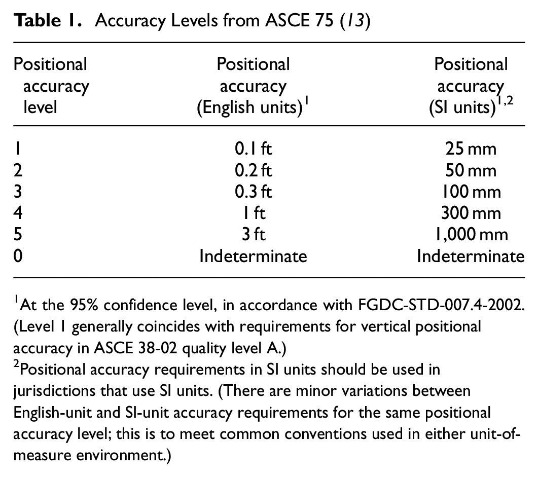
At the 95% confidence level, in accordance with FGDC-STD-007.4-2002. (Level 1 generally coincides with requirements for vertical positional accuracy in ASCE 38-02 quality level A.)
Positional accuracy requirements in SI units should be used in jurisdictions that use SI units. (There are minor variations between English-unit and SI-unit accuracy requirements for the same positional accuracy level; this is to meet common conventions used in either unit-of-measure environment.)
Methods
The objective of this research is to document the adoption of ASCE 75 by state DOTs, and its perceived benefits as well as the potential it offers for the development of a DAB standard for general construction work. To acquire a basic understanding of current research and practice concerning the ASCE 75 standard across state DOTs, the authors reviewed relevant literature in depth. Additionally, they were able to review unpublished elements of research previously conducted. The literature review identified state DOTs that the authors then reached out to for interviews to gain a deeper understanding of the current and future use of ASCE 75. Interviews were conducted with state DOTs that have already implemented draft versions of ASCE 75 and with DOTs that have not yet, but plan to do so. CDOT, MDT, Georgia DOT (GDOT), and UDOT were selected for interviews based on their explicit requirements for collecting utility as-built information to survey grade accuracy and within utility as-built mapping. PennDOT and DelDOT were selected for an interview (despite its lack of current requirements) based on their future plans for DAB collection about utilities.
Findings and Discussion
In the utility sector, the ASCE 75 standard is adopted and developed for capturing utility as-built data. ASCE 75 provides a standardized approach for collecting utility as-built data by indicating how frequent, to what accuracy level, and what type of information needs to be collected. However, no such standard exists for general construction as-builts. NCHRP Report 548 illustrates the need for developing a standardized approach for general construction as-builts.
Based on the recent analysis done in 2019, NCHRP synthesis 548 reported that, out of 42 responding state DOTs, 50% of the states said that they had a documented definition of construction as-built plans. This means that half of the states that responded to the survey, which is representative of the majority of DOTs, do not define what they mean by construction as-built plans (as seen in Figure 1).
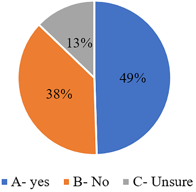
Documented definition of as-built plans.
The report also documented that the majority state DOTs capture the general construction as-built data by handwritten notes, electronic notes, or photographs. Collecting data in more digitized means, such as using 3D models or LiDAR, were in the minority of approaches used. There were also only three states using 3D-modeling to established as-built data (Figure 2).
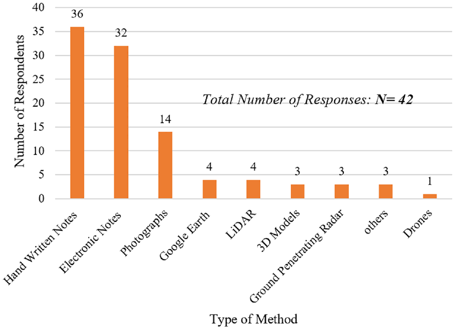
Methods use to capture and document changes.
A recent survey of 41 state DOTs conducted in the first quarter of 2021 as a part of NCHRP synthesis 53-04 noted that more than half of respondents indicated that ASCE 75 has not yet been used or implemented by their agency (69%, 27 DOTs). Using the information and the data gathered in the literature review, CDOT, GDOT, MDT, UDOT, PennDOT and DelDOT were interviewed to gather further details on individual state DOTs’ uses and their perceptions of the forthcoming ASCE as-built standard.
It was found that CDOT and MDT have experience in implementing the draft version of the utility as-built standard that provides the baseline of the positional accuracy requirement and the frequency with which utility as-built information could be collected. GDOT, UDOT, and PennDOT have future plans for implementing the upcoming utility as-built standard. The objective was to present perspectives from both groups; state DOTs that have implemented the draft version of ASCE 75, and state DOTs that plan to implement it in the future. The benefits of implementing ASCE 75 and its potential impact on general construction DABs are noted in the Discussion section.
Implementation Practices of ASCE 75 Standard
Table 2 offers a brief summary of the findings from discussions with state DOTs on their current practices or future plans concerning the implementation of ASCE 75.
Summary of Findings from State Departments of Transportation (DOTs) on the Implementation of ASCE 75
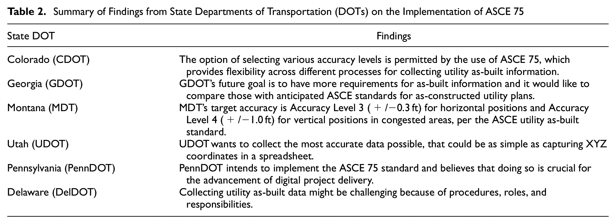
The following discussion describes the experiences of few state DOTs relating to their implementation of ASCE 75 or their future plans to use it.
CDOT requests 3D high-accuracy geospatial data to collect utility as-built information for permits and construction relocation projects. Special provisions are outlined in Chapter 6 "Construction Surveys” of CDOT’s Survey Manual and Section 625 of their Standard Specifications “Asset Geospatial Data Collection for Utility Relocation Construction.” CDOT indicated that they have prescriptive standards for data gathering procedures based on ASCE 75 pertaining to the accuracy of utility as-built information. Even before the official publication of the standard, a draft of the standard was available. CDOT expects level 1 or level 2 positional accuracy for utility relocation construction, since the standards are connected to its survey manual guidelines which are more stringent about accuracy. For permit proceedings, at least level 3 is expected. The white paper draft of the ASCE 75 standard is currently being used by CDOT; however, they anticipate using the ASCE 75-22 version once it has been released, and plan to incorporate the necessary qualities in both their manuals and Chapter 6 of their Survey Manual. The as-constructed information that has been collected is in digital form is based on the white paper published by ASCE 75. The white paper provides a minimal set of data attributes for each asset, including its age, material, owner, number of conducts, and permit number, among other pieces of information. CDOT’s long-term objective is to develop a connection to the One-Call ticketing administration system to enable the use of Application Programming Interface (APIs) to manage tickets and share as-constructed information.
GDOT gathers utility as-built data based on Chapter 3.B of the “Utility Accommodation Manual.” The district utility office keeps as-built plans from utilities for permitted utility installations and relocations. As-built utility data must meet GDOT design guidelines, but there is no specified accuracy. GDOT indicated that they are aware of the upcoming ASCE 75 standard and plan to use it. One of their key goals in the near future is to implement stricter restrictions for gathering as-built information. They are currently preparing a request for services to construct a GIS-based system for recording utilities and assets in the ROW owned by GDOT. For their design-build specifications, GDOT had already implemented as-built requirements, and these would be compared with the forthcoming ASCE utility as-built standard before implementing requirements for traditional projects. GDOT’s procedures and methods for managing, searching, and utilizing utility as-built information are crucial. However, GDOT’s future objective is to have more requirements for as-built information, but, as of now, they are waiting for ASCE 75 to be released.
MDT indicated that they have incorporated the ASCE 75 draft in the creation of their utility permitting system. The standard specifies, among other procedures, the accuracy levels and when survey points should be acquired. These regulations are also outlined in their utility manual, and, if a utility provider does not comply, MDT has the authority to withhold future permits until compliance is achieved. In the ASCE as-built standard, the required horizontal accuracy in urban areas for utility as-built information is 0.3 ft and the required vertical accuracy is 1 ft. Both horizontal and vertical accuracy in rural areas is 3 ft. Initially, MDT desired more precise data, but having two levels (urban and rural) and reduced precision was a compromise with industry stakeholders during the systems and rules implementation.
UDOT mandates utility owners report longitude, latitude, and elevation to 0.1 ft accuracy. This data is submitted in CSV format when moving or installing utilities. It collects only below-ground data. UDOT indicated that they intend to implement ASCE 75 as well. This standard is currently cited in their Survey and Geomatics Manual inside their methodology for utility as-built data. Based on this, UDOT intends to modify the current delivery format and data collection strategy. Their long-term objective is to create a utility as-built GIS map with metadata (a repository) that includes all the fundamental characteristics of each facility (type, size, etc.). This would be beneficial for design teams to have access to at least subsurface utility engineering (SUE) quality level-D (the most basic level of information about utility locations that is derived only from existing utility records or verbal recollections) information early in the project so that they may collect internal data for the design development.
PennDOT has created a system to request a highway occupancy permit, but it is not being used to collect as-built information. Collecting as-builts will require system changes. PennDOT indicated that they plan to implement ASCE 75 in the future. In addition, they are considering the policies of other states as they create their own. PennDOT noted that their Transportation Advisory Committee working on this effort is now only internal, but that it would eventually include other stakeholders, such as utilities, after they have more direction based on ASCE-75 and what other state DOTs are doing.
Delaware Department of Transportation (DelDOT) reported, based on the survey results, that they do not require utility as-built data and do not typically collect utility as-built data. Nevertheless, there are a few instances in which they acquire utility as-built information. In addition, utility companies can input the geometry of GIS components into their permitting system to get a permit. DelDOT does not consider this as-built nor accurate. DelDOT does not require a particular level of precision in the collection of utility data. Their regulations reference the collection of utility data, but they do not frequently collect utility as-built data and do not mandate quality level criteria for newly constructed utilities. DelDOT is working toward mandating utility as-built data as a regulatory standard, although resistance from the utility corporations is the major worry. Compliance with ASCE 75 and the need for survey-level precision are the primary problems. Many utility providers lack the capacity to execute at the level of quality required by these criteria.
Benefits of ASCE 75 and its Potential Impact on General Construction Digital As-Builts (DABs)
The application of ASCE 75 allows for the selection of various accuracy levels which can provide flexibility across different processes for collecting utility as-built information. NCHRP project 20-07 task 418 highlighted the potential for cost reduction as one of the most significant advantages of gathering georeferenced utilities as-built data—through damage prevention, $250,000,000 could be saved annually ( 1 ). Additionally, by reducing the scope of SUE investigation, $384,000,000 could be saved annually. In addition, having the geospatially accurate utility as-built data, the location of underground utility is known, so SUE becomes a tool that could be used to verify the as-built data ( 1 ). In addition, having accurate and reliable utility as constructed data will lower the amount of SUE needed, therefore the cost of the SUE is reduced. Once implemented, ASCE 75 would establish the well-defined framework for utility engineers, and coordination, asset management of networks, and exchange of information on utility infrastructure among the stakeholders. Recognizing that DOTs, such as PennDOT, are at the forefront of developing a comprehensive DAB implementation plan, ASCE 75 would be consistent with and support current and emerging digital project design standards and delivery practices, such as the “Digital Project Design and Delivery Standard.” DOTs will benefit from enhanced damage prevention, which includes the utilization of real-time augmented reality visualization technology and the global-navigation-satellite-system-improved utility locating by applying the standard guideline for utility infrastructure. Additionally, implementing ASCE 75 practices would result in robust, sustainable infrastructure and enhanced utility asset performance management.
DABs capture and store records of built infrastructure projects. DABs, when used, increase the efficiency and accuracy during project delivery and result in cost savings for post-construction asset management. DABs are capable of being utilized as digital twins, which are sophisticated representations of the structural system that allow agencies to speed maintenance and enhancement efforts. DABs are simple to maintain and reduce the time and resources required to create conventional 2D as-builts.
ASCE 75 provides a framework and the domain criteria applicable to all infrastructure types for the gathering of spatial and feature attribute data, in which distinct observations of lineal and point features are organized in a basic spreadsheet format with sufficient information to enable utility features to be modeled and rendered in spatially and geometrically accurate 3D virtual reality form ( 13 ).
It is important to note that implementing the new ASCE 75 standard for capturing utility as-built data may present certain challenges. Given that this is a new process, it may be necessary for consultants to modify their approach and determine the specific scope of data that must be captured. In addition, the collection of as-built data is typically performed during the construction phase, posing a challenge for consultants seeking to expand their scope beyond the design phase. In other words, it may be challenging to define and implement a consultant scope that incorporates both the design and construction phases of a project, and this could affect the collection and interpretation of as-built data.
Conclusion
Utility-related issues are identified as one of the top three reasons for construction project delay and this points to the need to capture georeferenced as-constructed utility information, as it could result in substantial savings. Incorporating DABs for general construction into project delivery can likewise enhance safety, reliability, and cost savings by making project details more accessible. This research highlights the current implementation practices of utility as-built standards, its benefits, and its potential impact on general construction DABs. Some state DOTs, such as CDOT, have already adopted a draft version of ASCE 75 and are seeking to simplify and accelerate their utility accommodation, permitting, and highway project coordination laws and procedures. Some DOTs, such as MDT, GDOT, UDOT, and PennDOT, have future plans for implementing the upcoming utility as-built standard. The utility as-built standard, once published, would facilitate the adoption of standard procedures and regulatory requirements that would result in capturing the data attributes of newly installed utility infrastructure and fixed documents of position defined by direct measurement methods. The standard practices and industrial applications for general construction DABs are still emerging but stand to benefit from ASCE 75’s success.
ASCE 75 offers DOTs more clarity and consistency, and, once developed, the standard guideline would serve as a best practice for the management, exchange, and governance of data among state DOTs and project stakeholders. Knowing the current benefits that ASCE 75 possesses, it presents the path forward by providing a much-needed framework that can be applied across all other types of infrastructure beyond just developing utility as-builts.
The benefits and challenges of implementing ASCE 75 by the consultant community are not discussed, which is a limitation of the study reported in this paper.
Footnotes
Acknowledgements
The authors gratefully acknowledge the valuable support of the college of Department of Civil Construction and Environmental Engineering State University and the Department of Civil Engineering at the University of Kentucky for their continuous support. The authors would also like to thank all the interview participants, without whom this research would not be possible.
Author Contributions
The authors confirm contribution to the paper as follows: study conception and design: P. Patel, R. Sturgill; data collection: P. Patel; analysis and interpretation of results: P. Patel, R. Sturgill, H. Nassereddine, B. Ramadan, Y. Li; draft manuscript preparation: P. Patel. All authors reviewed the results and approved the final version of the manuscript.
Declaration of Conflicting Interests
The author(s) declared no potential conflicts of interest with respect to the research, authorship, and/or publication of this article.
Funding
The author(s) received no financial support for the research, authorship, and/or publication of this article.
Any opinions, findings, conclusions, and recommendations expressed by the authors in this paper do not necessarily reflect the views of Iowa State University or the University of Kentucky.