
Abstract
With the rapid development of inland waterway transport, vessel traffic flow becomes increasingly busy. Ship-induced waves result in significant hydrodynamic effects on inland waterway infrastructures and ship navigation safety. The characteristics of ship-induced waves could not only provide a reference for ship hull form optimization but also support the scientific maintenance of waterway infrastructure. In the context of extensive field ship wave observations under complex circumstances, an optimized estimation formula has been proposed considering the influence of ship dimensions. Different dimensionless variables were introduced, and the estimation formula was optimized through the π theorem. Its coefficients were determined by the least square fitting method. A detailed comparison with the classic estimation formulae demonstrates that the proposed formula would provide accurate estimation of ship waves under various conditions in inland waterways. The root mean square error is reduced by approximately 49% in contrast with the traditional estimation formulae. Additionally, a high coefficient of determination was derived as 0.88, highlighting its versatility in maximum ship wave height estimation of inland waterways. The present study shares valuable insights into ship wave height estimation which would be beneficial for inland waterways planning and design.
Introduction
Recently, the development of inland waterway transport (IWT) has been concerned world-wide with the prominent issue of greenhouse gas emissions. Benefiting from inland waterway conditions and intelligent shipping technologies, inland cargo shipping shows a growing trend, for example, 4.791 billion tons in 2023 by China. Although IWT plays a significant role in the transportation of bulk goods, its impact on the river ecosystem and topography evolution should not be ignored ( 1 ). In confined waters (e.g., canals, lakes, ship locks), the hydrodynamic disturbance induced by navigating ships is be more profound than in open water ( 2 ). A detailed investigation of inland ship wave height characteristics would provide a reference for ship hull optimization and support the scientific maintenance of inland waterway infrastructure.
Vessels which travel on the water surface cause continuous impulse pressure disturbances and lead to surface undulations ( 3 ). The inherent characteristics of ship wave fields are complex, and depend on the ship speed and waterway parameters ( 1 , 4 ). Ship waves could be amplified onshore in shallow and confined waters, thus exerting adverse impacts on moored ships, embankments, bridge piers, and so forth ( 5 – 7 ). Besides, inland ship waves have been characterized as nonlinear and unsteady, generally consisting of divergent and transverse waves ( 8 ). To address the issues resulting from inland ship waves, great efforts have been devoted to field observations and numerical modeling in practical scenarios ( 9 – 14 ). He et al. conducted field observations of ship waves in the Zhenjiang Section of the Beijing-Hangzhou Grand Canal and discussed the relationship between the maximum ship wave height and ship speed near vertical embankments ( 15 ). Göransson et al. investigated the vessel traffic flow in the Göta Älv River, and recorded data on the maximum ship wave height ( 16 ). They compared the statistical data against an existing calculation formula of maximum ship wave height, and found that the Permanent International Association of Navigation Congresses (PIANC) formula can effectively predict the ship wave heights in an experimental river section, but a significant margin of error still exists in the predicted results. Although ship wave data could be derived directly by field observations, it is always time-consuming and the results are site-dependent. In recent years, numerical modeling has also been adopted to gain knowledge about hydrodynamics of ship waves. Rodrigues et al. modified the FUNWAVE model by incorporating a free surface pressure distribution function proposed by Li and Sclavounos, and simulated the ship waves in confined waters ( 17 , 18 ). Ship-induced waves were simulated with an improved accuracy. Zheng et al. explored the effects of ship waves on moored vessels in restricted waterways, and highlighted the significance of ship-induced wave disturbances ( 19 ).
Furthermore, numerical modeling has been coupled with field observations to achieve a thorough investigation of ship-induced waves. Mao et al. analyzed the characteristics of ship waves in the Xicheng Section of the Beijing-Hangzhou Grand Canal through field observations (
20
). By adopting the moving pressure field method, a numerical model based on Delft3D-FLOW was established to simulate the primary long waves. A remarkable linear correlation was observed between the non-dimensional maximum ship-generated wave height and the depth Froude number (specifically,
Considerable effort has been made to establish a robust estimation formula of ship wave height under various practical conditions. Based on the topographic data of Jianghuai Canal, Wang et al. conducted physical model tests of ship-generated waves in a laboratory flume ( 23 ). They calibrated the classic ship wave height formula by IHE Delft and proposed a novel calculation formula applicable to the Jianghuai Canal. The ship wave field analysis further supported the optimized design of revetment structure. Li et al. explored the effects of ship draft, speed, and bank slopes on the characteristic wave height, maximum wave run-up, and drawdown ( 24 ). They developed empirical formulae which were validated against the field observation data. Chakraborty et al. introduced the time-frequency analysis method to identify the transverse and divergent waves of ship wakes observed in the Hooghly River ( 1 ). Novel empirical calculation formulae were thus proposed for primary and secondary waves.
The aforementioned research promotes the development of ship wave theory, but most estimation formulae are only applicable in certain scenarios and are susceptible to ship type, waterway topography, and other parameters. In the context of waterway infrastructure management and intelligent shipping under complex circumstances, it would be beneficial to propose an optimized estimation formula for ship-induced wave height in inland waterways which would be easy to implement and applicable for various practical scenarios.
The remainder of this paper is structured as follows. A detailed introduction to related material and methods is presented in the next section. An optimized estimation formula is established and validated in the section after that. Discussions on the capability and applicability of the optimized estimation formula are provided in the penultimate section. Conclusions are drawn in the final section.
Material and Methods
Field Observation Dataset
Based on published literature, field observations of ship waves have been collected and summarized for a time range of 2008 to 2020 (7, 20, 22, 25–28). The relevant information, including waterway depth, ship draft, ship speed, distance from riverbank, and maximum ship wave height, has been extracted. High-speed ships which navigate at a supercritical speed may experience a loss in draft because of pressure drop ( 29 ). In such cases, the characteristics of the ship wave will undergo significant changes, and traditional wave height calculation methods will no longer apply ( 30 ). This situation is particularly prominent with small high-speed vessels which are less common in IWT ( 31 ). Therefore, field data with incomplete information, or data associated with high-speed ships and patrol boats, were excluded from the present study. An example of field data collection is presented in Table 1.
Field Data Collection of Ship Wave Height Based on Published Literature
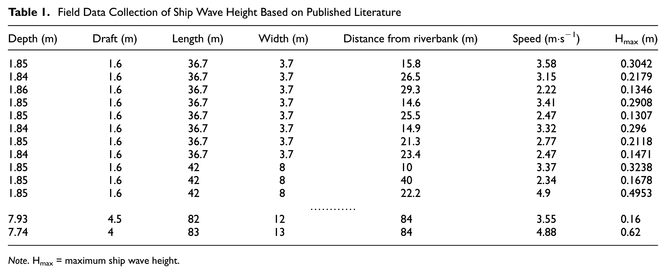
Note. Hmax = maximum ship wave height.
The data shown in Table 1 cover both urban canals and natural rivers. Because of the differences in waterway dimensions and navigating vessel types, the direct application of the aforementioned formulae may result in considerable errors in the estimation of ship wave height. Therefore, it is imperative to propose an optimized and versatile estimation formula for inland ship wave height.
Classic Estimation Formulae
Following the literature review, both the Blaauw formula and the PIANC formula have been widely adopted in the estimation of maximum ship wave height ( 32 , 33 ). In the present study, both formulae have been introduced and further compared with the optimized estimation formula. The definitions and applicable conditions of the Blaauw (Equation 1) and PIANC (Equation 2) formulae are demonstrated as follows:

where
s = the distance from the ship side to the riverbank, and
Equation 1 has been widely adopted to calculate the ship wave height in the literature ( 16 , 20 , 23 ).

where
s = the distance from the ship side to the riverbank, and
The PIANC formula is more commonly applied to shallow water conditions, where the ship-generated waves would have a significant effect on the sediment motions and riverbank erosion ( 1 ).
It is observed that both the Blaauw and the PIANC formulae share a similar structural form. Following the statistics in Table 1, the corresponding calculation results show significant discrepancies with the field data, as shown in Figure 1 for 95% confidence and prediction bounds.
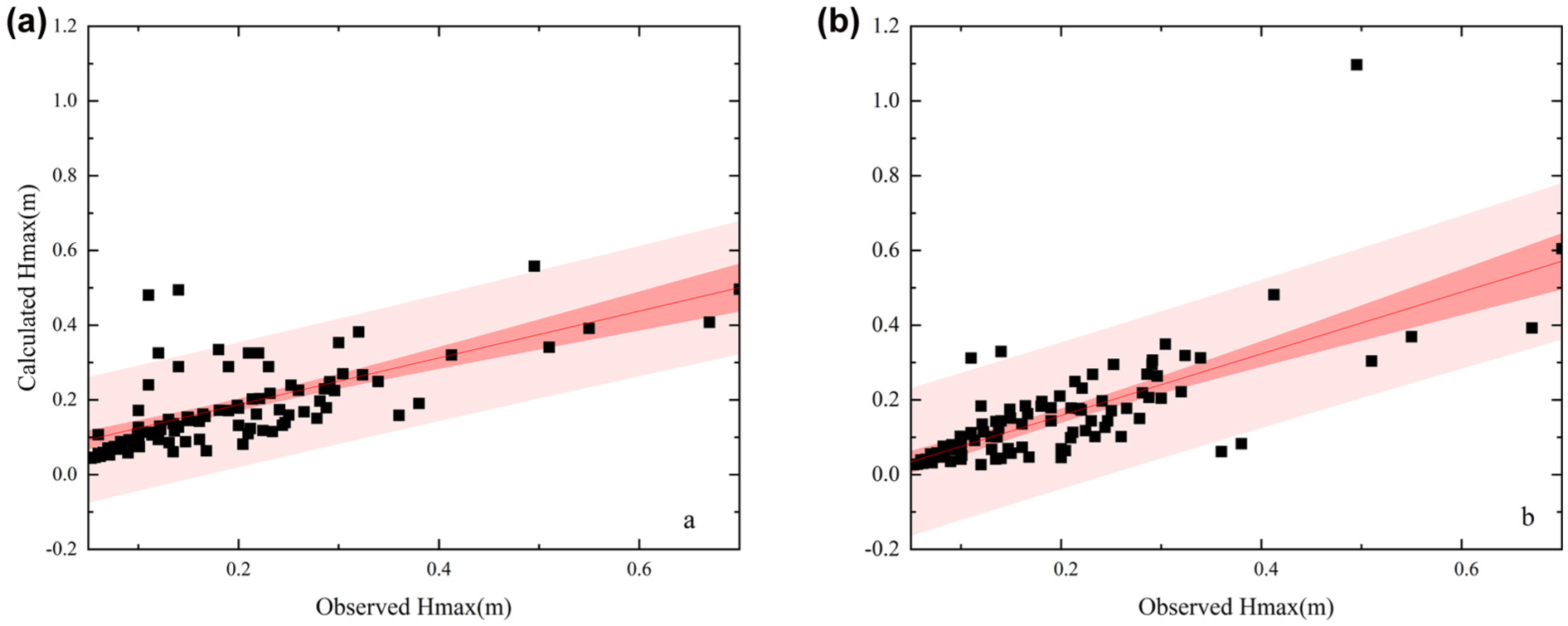
Comparison between the field observations and estimation formulae: Blaauw formula (left) and Permanent International Association of Navigation Congresses (PIANC) formula (right).
Following the comparison with field observations (see Figure 1), notable errors appear for ship wave height estimation by the Blaauw formula (Equation 1) and the PIANC formula (Equation 2). The root mean square error (RMSE) of the Blaauw and PIANC formulae equals 0.083 and 0.117, respectively. Therefore, the application of classic estimation formulae for maximum ship wave height has certain limitations in the broad context of inland waterways.
Optimized Estimation Formula of Ship Wave Height
Derivation of the Optimized Estimation Formula
As demonstrated in the previous section, both the Blaauw and PIANC formulae own a similar structure, with the difference lying in the exponents of independent variables. Based on Equations 1 and 2, an estimation formula is therefore proposed as follows:

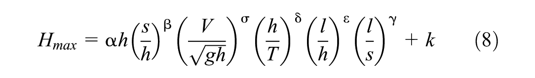
By adopting the water depth, distance from riverbank, and Froude number as independent variables, the undetermined coefficients a, b, and c could be calculated by the least square fitting method. Given a = 1.08, b = −0.58, and c = 3.15, a comparison between the observed and calculated maximum ship wave height is shown in Figure 2, with a confidence and prediction interval of 95%.
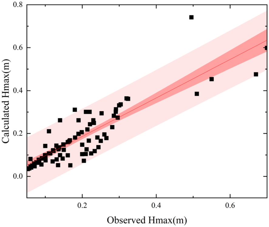
Comparison between the field observation and calculated ship wave heights.
Following Figure 2, RMSE was calculated as 0.089 for Equation 3. It is worth noting that the field observation dataset covers a wide range of vessel types, from small tugboats to large cargo ships, and the waterway types include both open waters and confined waterways. Therefore, a generalized ship wave estimation formula (Equation 3) may not be commonly applicable in practical scenarios. To improve its accuracy and robustness, the following influencing factors of maximum ship wave height have been considered and incorporated (as shown in Equation 4).

where
V = the average ship speed (m/s),
T = the ship draft (m),
h = the water depth of the waterway (m),
l = the ship length (m), and
s = the distance from the riverbank (m).
Following the dimensionless analysis and the π theorem, an improved formula can be obtained as follows:

where
Considering the significant variation in vessel types and inland waterway dimensions,

Rewriting Equation 6 into the form of a power function product, the following expression is obtained:
where
Considering the potential influence of natural flow field on the ship wave, an extra parameter
Performance Evaluation
By adopting the least square method for regression analysis, the magnitude of all coefficients is determined as
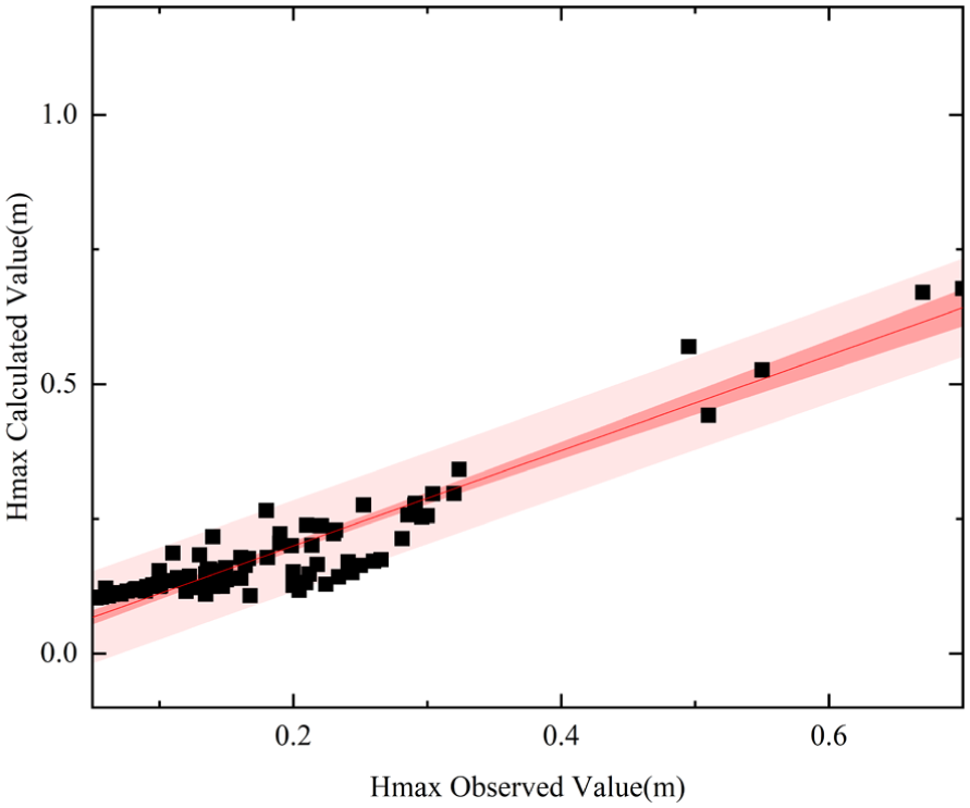
Comparison between optimized estimation formula and field observation of ship wave height.
It is noted that the optimized estimation formula (Equation 8) of ship wave height yields more accurate results than the classic Blaauw and PIANC formulae, which demonstrates the rationality of proposed formula. The proposed estimation formula allows for a more precise elucidation of the generation characteristics of the maximum ship wave height. In addition to the outliers recorded during field observations, factors such as wind waves and river discharge should also be considered appropriately.
Validation of the Optimized Estimation Formula
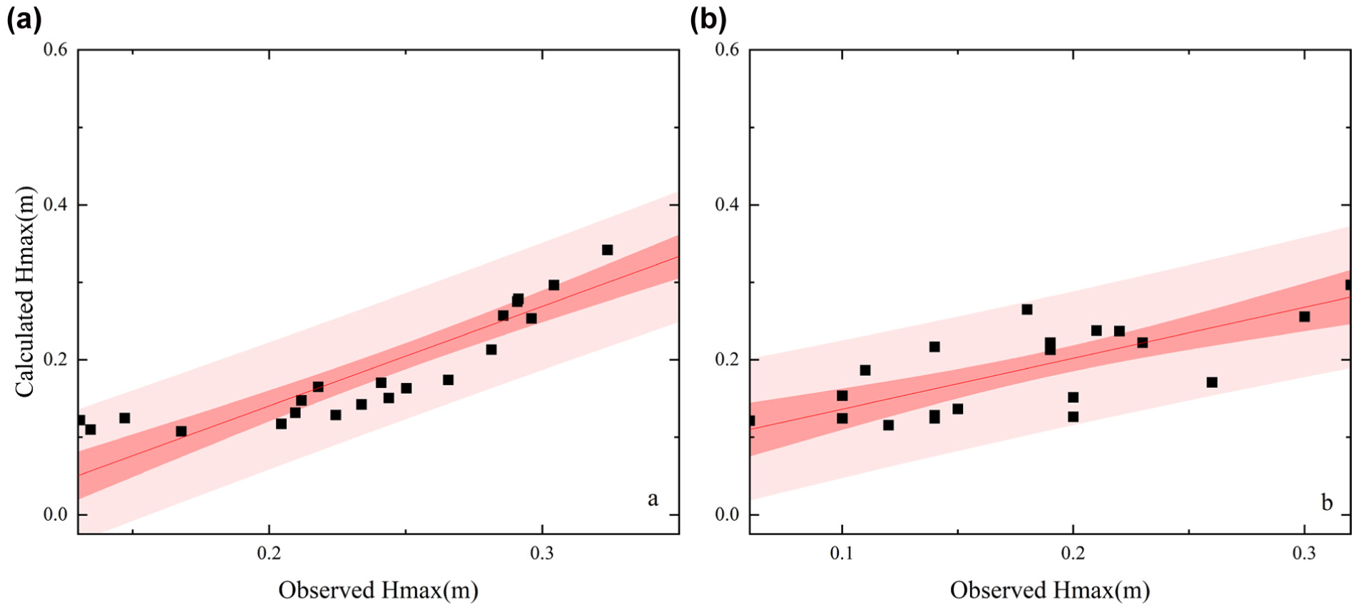
To validate the optimized estimation formula of ship wave height, further studies have been presented against the published data by He et al. and Göransson et al. ( 15 , 16 ). He et al. conducted field observations of ship waves in the Jiangsu Section of the Beijing-Hangzhou Grand Canal ( 15 ). Their modified Blaauw formula shares a similar form with Equation 3. Based on the field ship wave data, the corresponding coefficients are calculated through the least square fitting method for both formulae. The comparison against field observations is depicted in Figure 4.
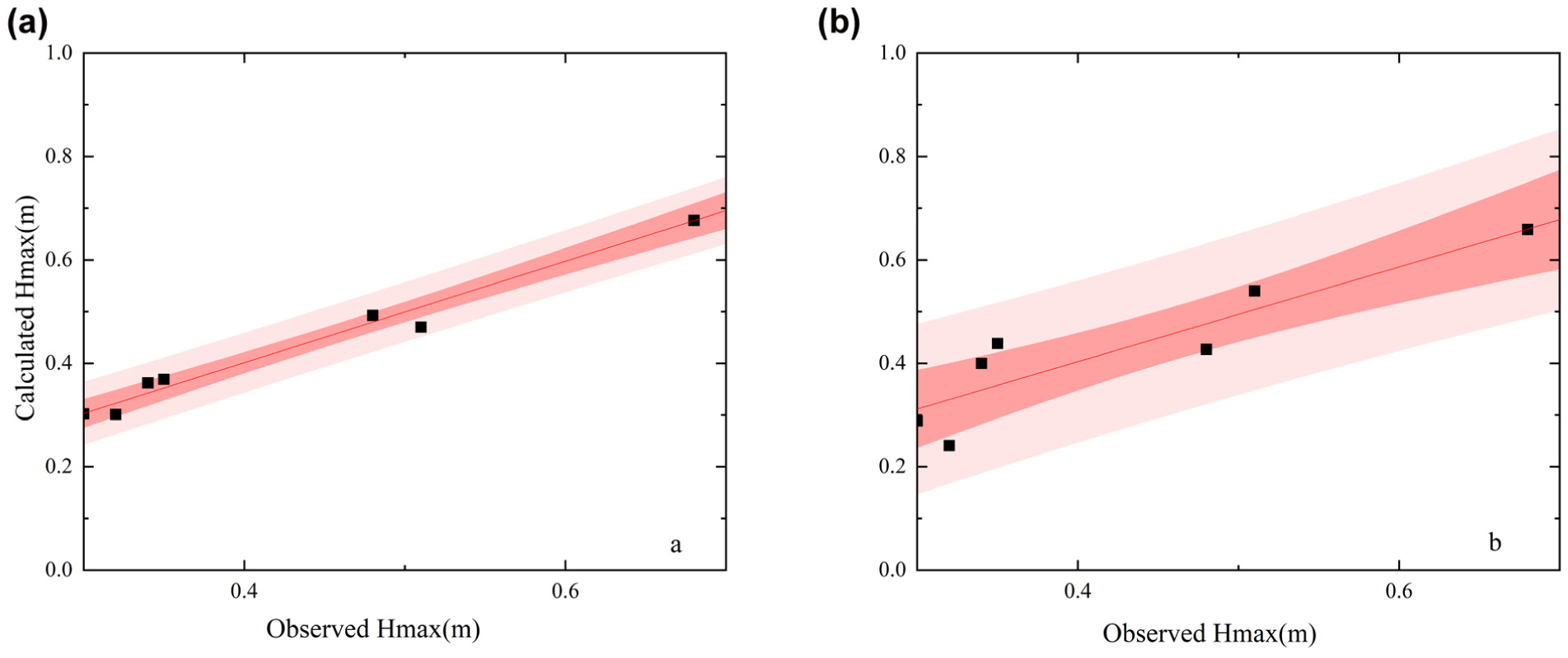
Comparison with field observations for: optimized estimation formula (left) and He et al. (right) ( 15 ).
According to Figure 4, the coefficient of determination (R2) for the modified Blaauw formula is calculated as 0.87, with an RMSE of 0.0535. With regard to the optimized estimation formula (Equation 8), the R2 and RMSE equal 0.98 and 0.0194, respectively. Therefore, the optimized estimation formula presents better predictive capability for the maximum ship wave height. Similarly, a comparative study has been conducted against the field observation data by Göransson et al., where the PIANC formula was adopted for maximum ship wave height estimation ( 16 ). The comparison against the field data is depicted for both formulae in Figure 5.
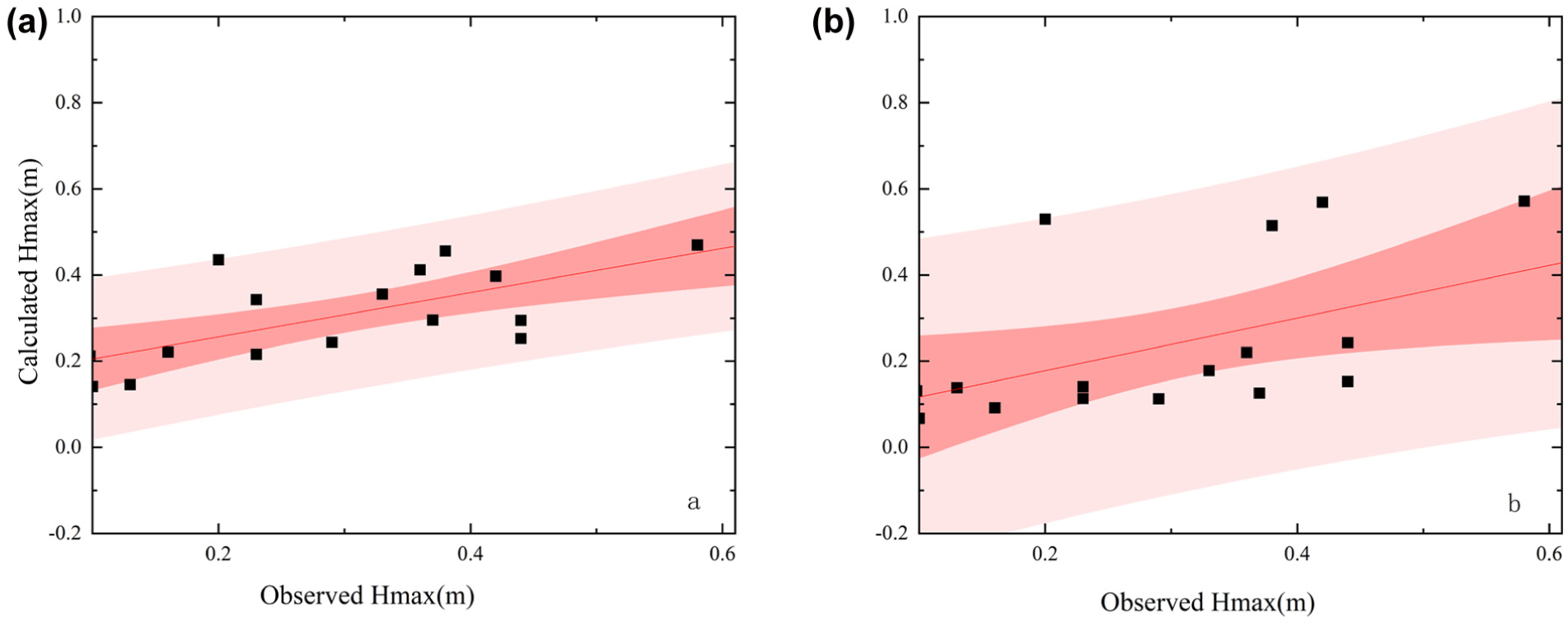
Comparison with field observations for: optimized estimation formula (left) and Permanent International Association of Navigation Congresses (PIANC) formula (right).
As shown in Figure 5, the data points were distributed discretely for both the PIANC and optimized estimation formulae. The RMSE was calculated as 0.174 for the PIANC formula, and 0.106 for the optimized estimation formula. Although the estimation accuracy is lower than expected, it shows a significant improvement over the classic PIANC formula. This might be attributed to the dimensions of navigating vessels and waterway involved in the literature ( 16 ). In relatively open waters, the generation and propagation characteristics of ship waves differ from those in constrained waters. Owing to bank effects and blockage effects, ship waves will undergo dynamic processes (e.g., superposition, reflection, and breaking), which are different from the dispersion characteristics of ship waves in open waters ( 26 ). This also highlights the importance of considering the vessel dimensions in the optimized estimation formula of maximum ship wave height.
Additionally, the study domain in the literature is a natural river with high annual runoff, and the riverbed is mainly composed of thick viscous sediments and a large amount of suspended sediment ( 16 ). The ship wave height would be influenced by river turbidity, leading to notable errors in wave height estimation. Based on the comparative study in Figure 5, the optimized estimation formula still outperforms the classic PIANC formula with an improved RMSE. Detailed discussions on the influencing factors of ship wave height estimation have been provided by Göransson et al. ( 16 ).
Discussion
Characteristics of Ship-Induced Waves
Refering to the optimized estimation formula (Equation 8), the impact of different influencing factors will be explored and further discussed. The spatial variations of maximum wave height with distances from the riverbank are compared with the field data derived by Mao ( 7 ). The author calibrated the modified Blaauw formula and analyzed the relationship between the maximum ship wave height and the distance from the riverbank. The variational patterns of maximum ship wave height with respect to the ratio of ship length to distance from riverbank and Froude number, is presented in Figure 6. The top three (hollow) symbols in the figure key represent the data from the literature, while the bottom three (solid) symbols represent the data derived from Equation 8 ( 7 ).
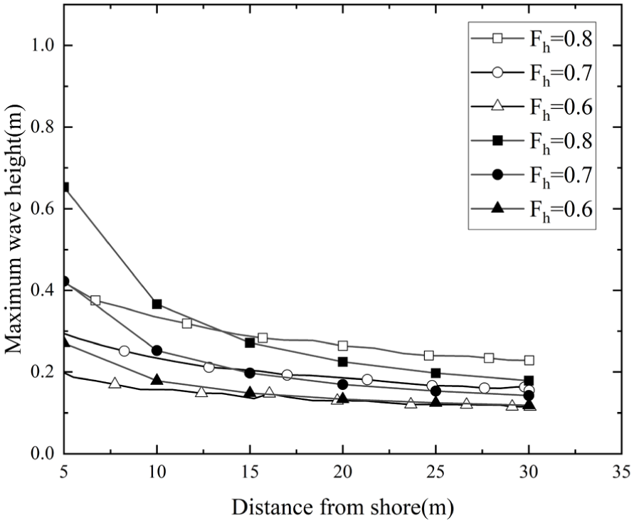
Spatial variations of the maximum ship wave height with different distances.
As shown in Figure 6, the maximum wave height gradually decreases as the distance from the riverbank increases. This indicates that, when a ship navigates from an open water area to a confined waterway, the maximum ship wave height would increase. This is consistent with the conclusion drawn by Mao ( 7 ). The spatial variations of maximum ship wave height generally agree with the field measurements, as shown in Figure 6. Besides, this finding demonstrates that a navigation route closer to the riverbank might result in greater hydrodynamic disturbances (e.g., ship wave energy and bank erosions). The increased shear stress associated with ship waves may result in the detachment of invertebrates and disturbance of littoral habitats ( 34 ). From the prospective of river ecology protection, minimum shoreline distances need be defined in inland waterways to mitigate the effects of ship waves.
Given an increasing Froude number, the variation of the maximum ship wave height is illustrated in the Figure 7. By comparing the results with literature, the best-fitting equations of the Froude number are further derived as below ( 4 ):

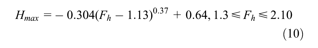
Very similar evolutionary features have been observed and the maximum ship wave height gradually increases with the Froude number (Figure 7).
Variation of maximum ship wave height with Froude number for optimized estimation formula and published literature.
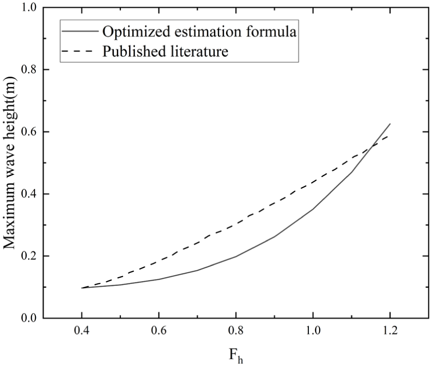
For different ship drafts, the variations of maximum ship wave height are illustrated in Figure 8. Following the results presented in the literature, it is noted that the maximum ship wave height would gradually decrease as the distance from riverbank increases ( 35 ). Furthermore, this decreasing trend remains for different ship drafts. Some deviations have been observed for both ship drafts, which might be attributed to the research domain of open water in the literature ( 35 ). The optimized estimation formula (Equation 8) is more suitable for research scenarios of inland waterways. Since the highest water level points are adopted as maximum wave heights by Li, the ship wave height estimations by Equation 8 fall below, as shown in Figure 8 ( 35 ). Overall, the evolutionary features are similar for both datasets.
Variation of maximum ship wave height with different ship drafts: 0.75 m (left) and 1.0 m (right).
Error Analysis of Ship Wave Estimation
The ship-induced wave height would be affected by the navigational conditions (e.g., river runoff, current, wind wave) in practical scenarios. In a river estuary, the tidal wave undergoes certain degrees of deformation along the waterway because of the influence of river discharge. The ship-induced wave propagation process becomes even more complicated as the tidal waves are superimposed ( 36 ). The field observations are divided into two categories: tidal river and natural river ( 20 , 27 ). Thus, the performance of the optimized estimation formula is evaluated and compared, as shown in Figure 9. RMSE is calculated as 0.0466 and 0.0624 for tidal river and natural river, respectively. The proposed estimation formula may achieve higher accuracy in the tidal rivers. Considering the complexity of wave propagation mechanism, more efforts need be made to incorporate various influencing factors (e.g., wind, riverbed geology).
Comparison of ship-induced wave height estimation for: natural river (left) and tidal river (right).
Practical Implications of the Optimized Estimation Formula
As IWT develops rapidly, the dynamic interactions between navigating ships and river revetments will become more intense. The accurate estimate of ship wave height will support the optimized design of ship hull form and engineering structures (e.g., river revetment and waterway training works). Following the innovative concept of a vessel train, developed by NOVIMAR, the estimation of ship wave height could guide vessel platooning in inland waterways, thus enhancing the economic feasibility and safety of waterborne transportation ( 37 ).
The optimized estimate formula of ship wave height (Equation 8) was obtained by adopting the π theorem and the coefficients were determined by the least square fitting method. Its current form could be applied in inland waterways and canals. Since the influence of various ship parameters (e.g., depth Froude number, ratio of ship length to water depth) have been incorporated in the optimized formula, its applicability could be further extended by fitting with extra field data and incorporating machine-learning-based models ( 38 , 39 ).
Conclusion
With the rapid development of IWT, the hydrodynamic impacts of ship waves cannot be ignored, especially in confined waterways. Although some classic estimation formulae have been proposed and adopted for maximum ship wave height, their applicability differs in practical scenarios. Considering the various influencing factors, an optimized estimation formula has been proposed based on the traditional Blaauw formula. Some preliminary conclusions have been drawn as follows:
Different dimensionless variables were introduced, and the estimation formula was optimized by adopting the π theorem. The coefficients of the optimized estimation formula were determined by the least square fitting method. A detailed comparison with field measurements further verifies its capability and versatility, with RMSE reduced by approximately 49% and R2 equaling to 0.88.
The maximum ship wave height would be influenced by various factors. It tends to increase as the distance from the riverbank decreases, which highlighting its potential impacts on inland waterway infrastructures. Besides, an increase in Froude number or ship draft would also lead to a higher maximum ship wave height. The comparative study demonstrates that more accurate estimation was obtained for tidal rivers. From a prospective of sustainable IWT, thresholds of ship speed and distance from the riverbank need be properly explored.
It is worth noting that the maximum ship wave height would be influenced by river runoff, wind waves, and shipping activities, which deserve further investigation in the future. Moreover, machine-learning-based models might be established to provide robust and accurate estimations of maximum ship wave height, regardless of the complexity in the practical scenarios of inland waterways.
Footnotes
Author Contributions
The authors confirm contribution to the paper as follows: study conception and design: S. Chen, Z. Jiang; data collection: H. Sun; analysis and interpretation of results: S. Chen; draft manuscript preparation: X. Yan, S. Chen, Z. Jiang. All authors reviewed the results and approved the final version of the manuscript.
Declaration of Conflicting Interests
The authors declared no potential conflicts of interest with respect to the research, authorship, and/or publication of this article.
Funding
The authors disclosed receipt of the following financial support for the research, authorship, and/or publication of this article: This work was supported by the National Natural Science Foundation of China (Grant Nos. 52071250 and 51709220) and the Science and Technology Program of Zhejiang Provincial Department of Transport (Grant No. 2023017).