
Abstract
It is indeed a prevalent fact that the inception of the rail transport system in the nineteenth century apparently reoriented the fate of numerous urban places of varying size classes. Towns which relished the visible regional prevalence for decades found themselves neglected when railways bypassed them. On the contrary, small market centres of purely local interest suddenly attained unprecedented gravity of importance as the railway lines rerouted the anterior business of the coaches towards them. Thus, on the one hand, the inception of railways and a consequent change in the former trade routes gave birth to a considerable number of new towns, on the other hand, it facilitated an urbanisation process in most of the existing important urban centres. This article aims to shed light on the traits of urbanisation and urban development in India, stimulated by the inception of railways and expansion of the network during the British period with a special focus on some select colonial cities and towns. Several archival and gazetteer sources have been consulted to establish a relationship between rail transportation and urbanisation in India during the colonial period. This study, after a careful analysis of the available information in the public domain, pertaining to the relationship between railways and urbanisation on both the Indian and worldwide scale, has inferred that railways undoubtedly induced some growth effects on the urban centres of India, but those effects were highly peculiar to the people and the places. The growth effect was magnificent in the principal chairs of colonial power, that is, the port cities, in the inland cities where trunk railway routes got converged upon the existing settlement and, finally, in the new towns which were cradled around some newly built railway stations and workshops.
Introduction
The rail transport system was one of the most extraordinary and resourceful imperial undertakings, which coincided with the social and economic growth of colonial India and made a massive contribution to their production. On 15 April 1853, Lord Dalhousie, the then Governor General of India, wrote a minute on the prospect of great trunk railway routes in India, which in the later decades became no lesser than a blueprint of colonial railway policies in the country. Lord Dalhousie, as the President of the Board of Trade in England, had gathered much valuable experiences on railway administration, by the time he became the Governor General of India.
1
He was not really satisfied with the initial proposals of the Court of Directors on short experimental lines. ‘I conceive’, as Lord Dalhousie wrote, ‘that experimental lines of small extent are at this day are no longer requisite’.
2
In his minute, he readily advocated for the necessity of great trunk railway routes in Indian Empire that in turn could link the prime chairs of colonial powers, that is, port cities with each other, with their hinterland and with other provincial towns and cities. He projected the first trunk line ‘from Calcutta by the valley of the Ganges to Delhi … touching every important military station from Calcutta to the Sutlej, connecting every depot, Allahabad, Agra, Delhi, Ferozepore, with the arsenal in Fort William’.
3
He further wrote:
…a line be formed in the Presidency of Madras by Menil (which point has already been sanctioned) by Vellore, Vaniyambadi, Coimbatore and thence to Western coast, with a branch to Singanallur and a branch also to the foot of the hills towards Ootacamund … another line should be constructed in the Presidency of Madras from the city of Cuddapah to Bellary, that surveys should be made with a view to its extension around the table land to Poonah in the Presidency of Bombay in order, thereby to form a junction with the Western Coast.
4
The trunk line from Bombay to Delhi was proposed through the Central Provinces.
The later decades from the appearance of Lord Dalhousie’s ‘railway minute’ experienced a strategic expansion of the railway network throughout the entire length and width of the British Indian Empire. The rapid and extensive establishment of railways involved the large-scale movement of private British capital to India between the 1840s and 1870s, which was the largest single unit of international investment in the nineteenth century. 5 Consequently, railways facilitated and cheapen the means of communication and production and led to rapid progress in the country both socially and materially. 6 It also enlivened the readiness of the administrative system and contributed to the formation of a national network of settlements. Clearly enough, the physical and functional proliferation of urban centres in British India was largely influenced by the colonial railways. A visible part of imperialist finance capitalism emerged in the form of railway investment, which shaped the urbanisation process in many pre-railway colonial cities such as Calcutta and Bombay, had also influenced the formation of new administrative centres like New Delhi and, most importantly, led to the creation of a new category of urban-industrial settlement known as ‘railway towns’. Thus, the geographical configuration of the railway infrastructure in urban places, spatialised by the imperial finance capitalism, spawned a new urban geography in Indian cities and towns during the colonial age. 7 Michael E. Bonine, for instance, referred to the contribution of railways to the population growth of urban centres due to employment opportunities created by it as well as its auxiliary economic undertakings. 8 Similarly, D. Goodman presented an enlightening discussion regarding the influence of railway lines on the morphology of cities. 9 In 1899, Robert Clarke, the then deputy commissioner of Delhi and the president of Delhi Municipality, proffered a memorandum in front of a select group of European and Indian municipal members, where he graciously pointed out that the urban responses to railway expansion affirm that how the proliferation and management of rail-borne traffic were seen as being intricately associated with the prosperity of Indian cities during the 1890s. 10 All these scholars have pointed out the impact of railways on the origin, functioning, growth and expansion of urban places from a variety of perspectives. However, there is no rule of generalisation in this regard. As Jack Simmons has asserted, ‘[t]owns and villages are as individual, as unpredictable, as human beings, and generalisations of this kind will seldom fit them all’. 11
The impact of the railway system on the accretion of an urban place could be comprehended in many ways. For instance, railways could lead to the expansion of the population by the aptitudes it offered, transporting people from other towns or from surrounding villages to live and work there, to provide and purchase or to carry them elsewhere. It could pave the path for suburbanisation, to accommodate such immigrants or enable prosperous urbanites to live away from the crowded city cores. It could assist prevailing industries or aid fresh industries to grow, through transporting raw materials and finished products from and to the places of interest. It might foster industries that ministered their own need, like manufacturing of railway tracks, locomotives, coaches, chairs, axles and many more. 12 Therefore, the importance of using railway services for movement in and between urban centres is a well-recognised fact, and it is also very true that railways played a transformative role in the economic and physical fabric of urban centres of different sizes, at a different scale. W. W. Rostow, in his book The Process of Economic Growth, stated that the railway system has induced a visible transformation of old urban places and led to the genesis of new ones, not only for direct railway-generated employment opportunities but also for the enormous commercial traffic and consequent marketing opportunities. 13 These lateral effects have led to an increase in the number of dynamic people in the total population and encouraged modern attitudes to the production process. 14
Railways, one can argue, constructed the infrastructural heart of British India after the mid-nineteenth century. The introduction of railways in India decisively contributed to the emergence of a national network of urban places, in which the metropolitan cities formed the primary foci, supported by 1 lakh cities which acted as satellite centres. 15 As a result of railway expansion in India, by the end of the nineteenth century, all the large inland and port cities of Indian Empire were connected via railway networks, which in turn linked a considerable number of intermediate small towns to the large urban centres of the territory. With the help of rail links, some new towns came into existence, while the existing units rose on urban scale. 16 Consequently, with the advent of railways, many obscure villages had grown into towns, several towns into cities and some cities have become so large as to collate graciously in population, area and modern services of living with some of the major metro centres of the world.
In order to recognise the existing urban landscape and the prevailing system of settlements in a country, an evaluation of the past changes is inescapable. However, there have been remarkably a scare number of attempts to appraise how urbanisation and urban development in colonial India were shaped by the inception and expansion of colonial railways.
17
The article aims to offer a general understanding of mechanism of geographical relationship between railways and urbanisation in colonial India, from a historical perspective. Since the present endeavour aims to explore the relationship between colonial railways and colonial cities, it takes a deep dive into the prevailing body of knowledge, produced by historians as well as varied government departments. To illustrate, the research is based on archival and gazetteer sources, where several official reports published during the British period, imperial and state gazetteers, historical accounts on select case studies etc. have been consulted, fused and eventually interpreted in a new manner, probably never contemplated before in the present sense. Thus, the research will enable us to conceptualise, with more clarity and coherence, the role that railways played in the urban map of India during colonial age. The study is grounded on some specific cases, where each case has a specific rationale for selection. The first group of urban places are suited for the scope of this study because they were the largest cities during colonial time and were the origin points of the Indian Railways. Calcutta, Bombay and Madras are the centres where Indian Railways steamed out its journey. Administratively, British India was organised in a hierarchy of places of descending power, prestige and geographical scope, with authorities of greatest power seated in these three colonial port cities of Bombay, Calcutta and Madras.
18
The second group of urban settlements, from Kharagpur to Jamalpur, are chosen for the present study because they are the sole creations of British Indian Railways and, therefore, fit well to Jack Simmons’s definition of railway towns:
It [ railway town] may be confined to those places that were developed by railways for their own purposes, either from nothing or by the addition of a new industrial plant to an existing village or market town, an addition so large as to engulf the older place and to make the combined settlement a town dominated by the railways.
19
A Brief Review of the Existing Historiography on Railways and Urbanisation in India
It is indeed a prevalent fact that the inception of the rail transport system in the nineteenth century brought about visible changes in the fate of British India’s urban places. Towns which relished a substantial regional prevalence for decades found themselves relegated when railways bypassed them. On the contrary, small market centres of purely local interest suddenly attained unprecedented importance as the railway lines rerouted the anterior business of the coaches towards them. Referring to the conspicuous imprint of the railway system on the transfiguration of Indian towns/cities, Ian J. Kerr,
20
in his book Railways in Modern India, pronounced, ‘[t]he socio-physical morphology of many of South Asia’s cities soon displayed the impress of railway development…’. He broached the demographic and social diversities brought about by railways to the urban centres of India. Similarly, Manu Goswami, in her seminal book Producing India: From Colonial Economy to National Space, shed light on the ‘ideologies of the postmercantilist colonial political economy of space’
21
by emphasising the transformative role of railways in eliminating ‘spatial barriers to circulation and production by opening up new sources for raw materials and markets for British manufactures’.
22
She has further emphasised that, by 1867, nineteen out of the twenty largest pre-railway urban centres of British India (as of Census 1872) were parts of the imperial railway network. While making sense of the spatialised political economy of colonial railways and the corresponding process of urbanisation, Goswami notes that
the regions most densely traversed by rail lines—from Karachi and Surat in the northwest into the Punjab through the Indus river basin, from Calcutta across the Gangetic plain into Punjab, and down the western coast from Bombay and Madras and inland into present-day Maharashtra, Karnataka, and the Deccan—became the dominant economic regions.
23
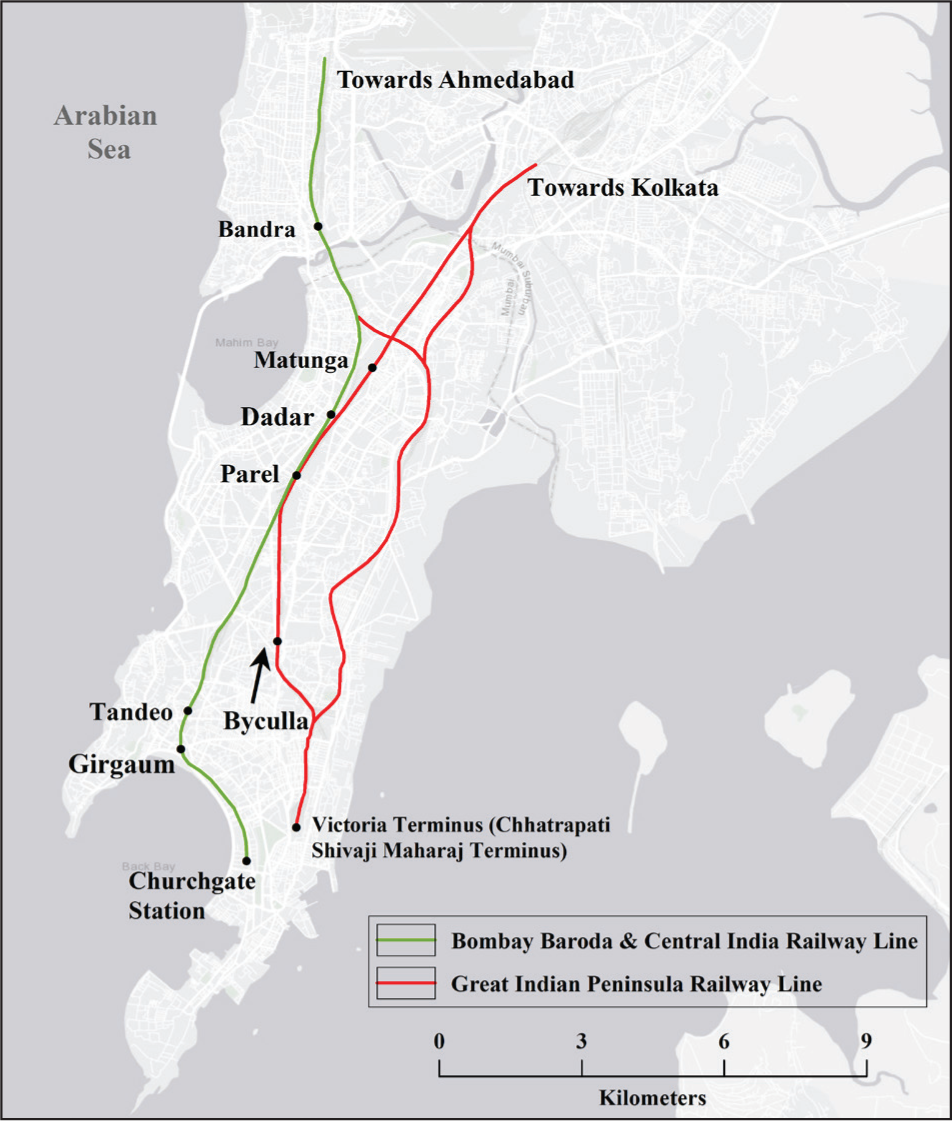
Moreover, Bandyopadhyay 24 took an initiative to exemplify the urbanisation and de-urbanisation effect of rail transport in western India by taking the reference of Bombay Baroda and Central India Railway system (BB and CIR). The study revealed that the BB and CIR had stimulated urbanisation in all the prominent urban clusters around it, such as Ahmedabad, Bombay, Surat and Bharuch, whereas the same railway system induced a de-urbanisation effect on some port centres, such as Cambay, Dhollera, Gogha and Tankaria, as these towns have lost their importance due to the alteration of former trade routes by the railways.
While drawing largely from the historical role of railways on the suburbanisation of major colonial port cities, Cristian Wolmar 25 extended the idea of a dialectic relation between railway expansion and urban growth in colonial India to a more comprehensive notion of railways as an element of national identity formation. Apart from these discussions, a considerable number of studies have focused attention to the individual Indian towns/cities that are the bright creations of colonial railways. 26
A parallel foregrounding of the historical–spatial imagination established by the existing historiographical studies has moulded the choice of particular case cities in this research to elaborate the impact of colonial railways on urbanisation in India. The principal aim is to expand the scope of historical and geographical thinking about colonial cities in India by unfolding new ways to comprehend how colonial railways could be historically conceptualised and geographically perceived as a pivotal element of technological and infrastructural intervention that has not only influenced but also directed the urbanisation trajectory in India during the last half of the nineteenth and early half of the twentieth centuries.
Discussion: Railways as a Spatial Agent of Urbanisation in Colonial India
Railways were at the technological and organisational core of a great deal of social, economic, political and institutional metamorphosis that contributed substantially to the production and transformation of urban space in colonial India.
…It [Railways] linked the centres of population; and the cities, which until then had been identified with their temples and forts, became identified with their railway stations, Howrah with Calcutta, Victoria with Bombay, Egmore and Madras Central with Madras. It involved millions of people, it required immense paperwork, the clipboard, the manifests in triplicate, the endless chain-of-command from Director to Sweeper-so it suited the complexity of Indian life, and it was an institution of limitless subtlety. Aesthetically, it was pleasing. 27
The colonial rule sought to engrave itself on the territorial space of the Indian Empire and implant the colony within a greater imperial political economy. 28 A graciously conceived urban history, grounded on the geography of railway tracks, therefore, is imperative to get an important insight into the fundamental dynamics of the urban historical geography of colonial India. Note that the railway system induced both urbanisation and de-urbanisation effects during the colonial period in India, but the de-urbanisation effect was largely limited to some of the small port centres that became relegated when the railway rerouted the former direction of trade and passenger traffic. On the contrary, the urbanisation effect was much more widespread, as railways were different from other forms of colonial undertakings like plantations or mines; they had a pan-India presence. 29
The first passenger train of India steamed out of Bombay, destined to Thana, for a distance of 21 miles on 16 April 1853. The route miles under operation became 838 in 1860 and 23,672 by 1900, becoming Asia’s largest and world’s fourth-largest railway network. 30 After the completion of five decades from the year of inception of passenger railways in India, it became evident that a large number of companies (e.g. East Indian Railway Company, Great Indian Peninsula Railway Company, Madras Railway Company, etc.), the imperial government and the native Indian states had persuaded the construction of railway tracks in different parts of the empire under a variety of management practices. However, it is undeniable that each railway company and every process of railway organisation gave a physical, demographic and functional growth impetus to the colonial cities by integrating labour markets, transporting people and facilitating the smooth flow of commodities across provincial boundaries.
Railways and the Principal Port Cities of Colonial India
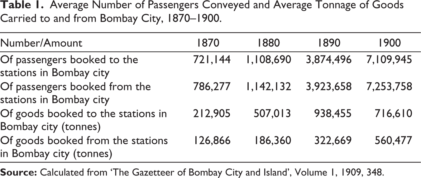
Railways were first gauged on a very limited scale in India and were conceived as experimental lines of short lengths: from Calcutta to Raniganj (120 miles), from Bombay to Kalyan (33 miles) and from Madras to Arkonam (39 miles). 31 Thus, of all the cities of colonial India, Bombay, Calcutta and Madras perhaps have substantial ground to feel pride in their railways. The alteration in trade routes initiated by the system of colonial railways brought about a corresponding transformation in the socio-functional organisation of port cities. 32 Improved means of communication had accelerated the importance of urban centres along the railway routes or junctions. Two railway systems, such as the Great Indian Peninsula Railway (GIPR) and the BB and CIR, played a transformative role in the economic and physical development of Bombay city. Raw materials were brought to Bombay via railways from the interior parts of peninsular India for being shipped to far-off places in the West, while the finished industrial products from Europe could be sent from Bombay to faraway places by the hands of railways. Furthermore, railway services stimulated industrial growth in Bombay, especially the growth of the cotton textile industry, by providing direct access to raw cotton tracts of Deccan Plateau on the one hand and the consumer market on the other hand. In 1850, even the model of a cotton mill could not have been found in Bombay, but shortly afterwards, the enormous imports of piece goods (Table 1) and yarns from Lancashire set the merchant community wondering whether it might not be feasible to fight Manchester with her own weapons and themselves supply the demands of the Presidency and the Island. 33 In 1854, the first cotton mill was introduced to Bombay and by the end of the decade, six more mills were opened. The quantity of cotton imported to Bombay by the railways had more than trebled since 1880, and the quantity carried in 1905 amounted to 339,047 tonnes as compared to 89,115 tonnes in 1880. 34 Railways not only contributed to the status of Bombay as the cotton polis of India, but it was also the part of a large industrial undertaking in the city, as specified by Kerr, ‘Railways provided India with the overall largest and the most dispersed form of industrial employment in colonial India: the railway workshop’. 35 By 1918, the railway workshop of GIPR in Bombay employed nearly 5,000 heads, 36 making it one of the largest individual industrial undertakings of colonial India. The GIPR’s goods terminus at Wadi Bunder, immediately contiguous to the docks, was aligned at right angles to the lines of a siding serving the dock berths; the BB and CIR was on the other side of the Frere Road and could connect with the dock berths only by running over a portion of the GIP Railway; goods intended for export, brought by either line, had to be first cart from the goods terminus to the owners’ godown, then unloaded and thereafter re-loaded and carted to the dock berths, a process involving the expense of double handling, which constituted a permanent and not inconsiderable charge on the trade. 37
Average Number of Passengers Conveyed and Average Tonnage of Goods Carried to and from Bombay City, 1870–1900.
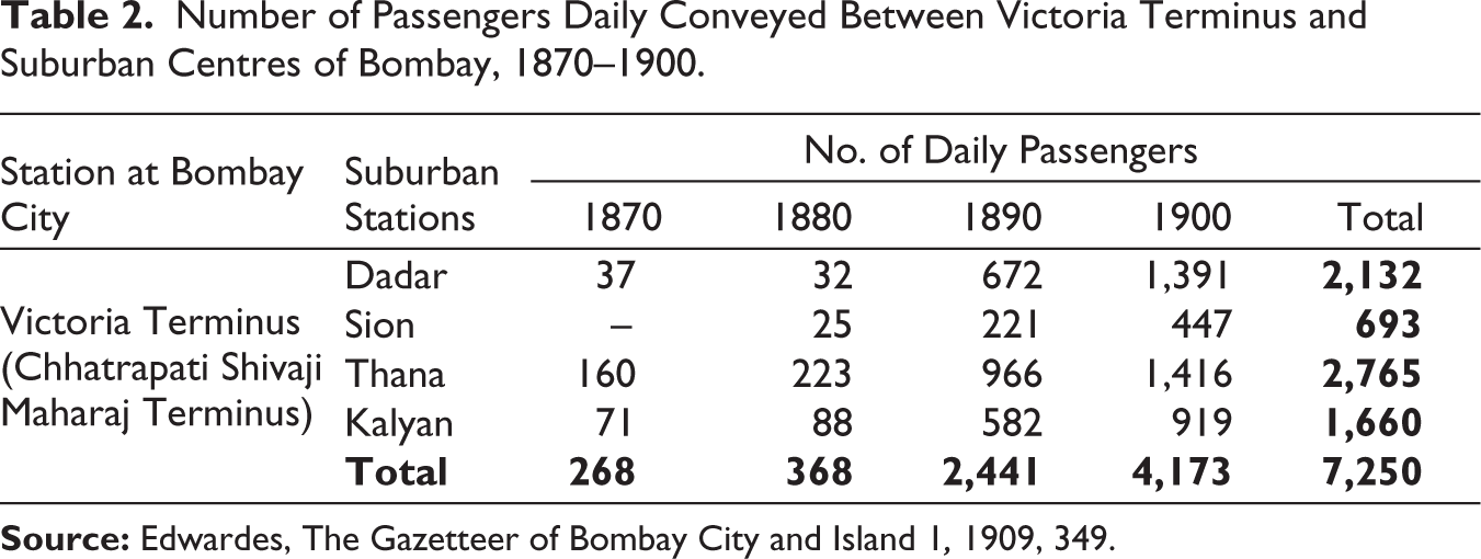
The same network of railways, which stimulated economic prosperity of the city of Bombay and reshaped its land-use pattern, simultaneously lent a hand to reorganise the socio-spatial configuration of the city through boosting suburbanisation (Figure 1). Bombay’s slender insular peninsular location, space crunch, increasing population and high rents forced many inhabitants to move towards the north of old Bombay to avail decent and economical residences. Railways at the same time provided opportunities for daily communication to and from the place of residence. Therefore, this new mode of transportation expedited the mobility of people towards the northern direction, outside the southern administrative, industrial and commercial core of the Island city (Table 2). The memorandum of the Bombay government in 1907 had referred to the feasibility of free and frequent communication by railways as well as of cheap workmen’s trains which would enable the working class to be accommodated in the less frequented portions of the Island, that is, the suburbs, where land was available on comparatively easy terms. 39 As a result, the suburban centres, such as Bandra, Thana, Kalyan, Kurla and Borivli, had started emerging as demographic and economic nuclei by virtue of the railways. As noted by Chattopadhyay, middle-class residences of Bombay ‘moved away from the city centre during the plague to set up suburban communities along the railway lines, which created the template for Bombay’s suburbanization in the twentieth century’. 40 Furthermore, railways endowed the city with their most magnificent station buildings, which later on added to the image and identity of the city. Recognising this image-forming role of the railway station, Hazareesingh stated:
Number of Passengers Daily Conveyed Between Victoria Terminus and Suburban Centres of Bombay, 1870–1900.
…During the late nineteenth century, there emerged a range of public edifices…. Most prominent of all was that architectural ode to the imperial venture, the Victoria Terminus building: with its deliberate, unsubtle symbolism—it featured mounted figures representing ‘Progress’, ‘Commerce’ and ‘Engineering’—the new railway terminal clinched the Fort’s function as the spatial embodiment of an emerging colonial industrial modernism. 41
Subsequently, the GIPR from 1925 and the BB and CIR from 1928 started the electrification of their respective suburban lines, which tremendously boosted the suburban passenger traffic of Bombay. In the GIPR, the increase in the number of passengers carried, following electrification, was 29%, compared to a 2% increase on the BB and CIR up to 1930. 42 Thus, the city of Bombay had started growing spatially and demographically. In 1872, the population of Bombay city was 644,405, which increased to 773,196 and 821,764 in 1881 and 1891, respectively.
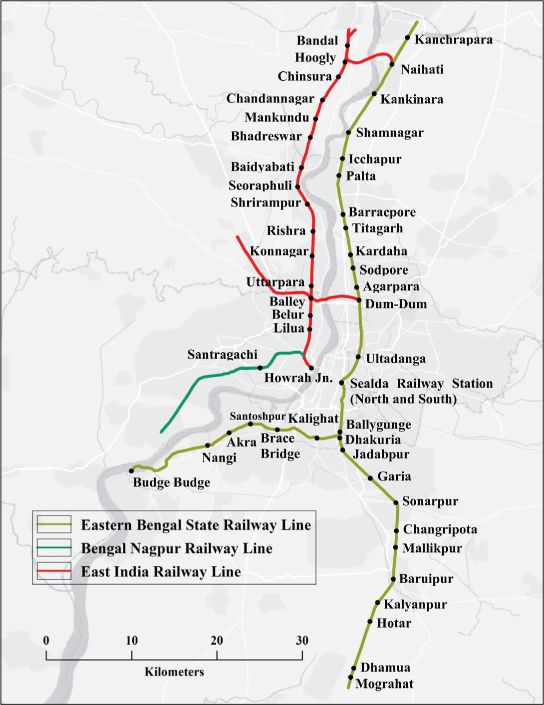
The initial development of the railway network in the eastern part of the British Indian Empire radiated out from the port city of Calcutta towards the rich, fertile tracts of the North Indian plain. The city of Calcutta was the principal seat of the British Government in India and the general residence and office of the Governor General during winter until 1911, when the winter capital of British India was shifted to New Delhi. Three great railway systems of India were built to converge on Calcutta. The East India Railway (EIR) connected Calcutta to the United Provinces, Punjab and later with Bombay; its terminus was on the west bank of the Hooghly River, at Howrah, which later became the largest and busiest railway station of India. The Bengal–Nagpur Railway (BNR), which ran through Odisha to Madras and westwards through Central Provinces to Bombay, also terminated at Howrah. And lastly, the Eastern Bengal State Railway (EBSR), which terminated at Sealdah Station, connected Calcutta with northern and eastern Bengal, with Assam and later with Diamond Harbour. This article argues that the railway transport systems in Calcutta were a bright contribution of colonial modernity, an absolute cause for the economic prosperity of the city, which in turn contributed to the status of the city as the ‘capital’ of the Indian Empire.
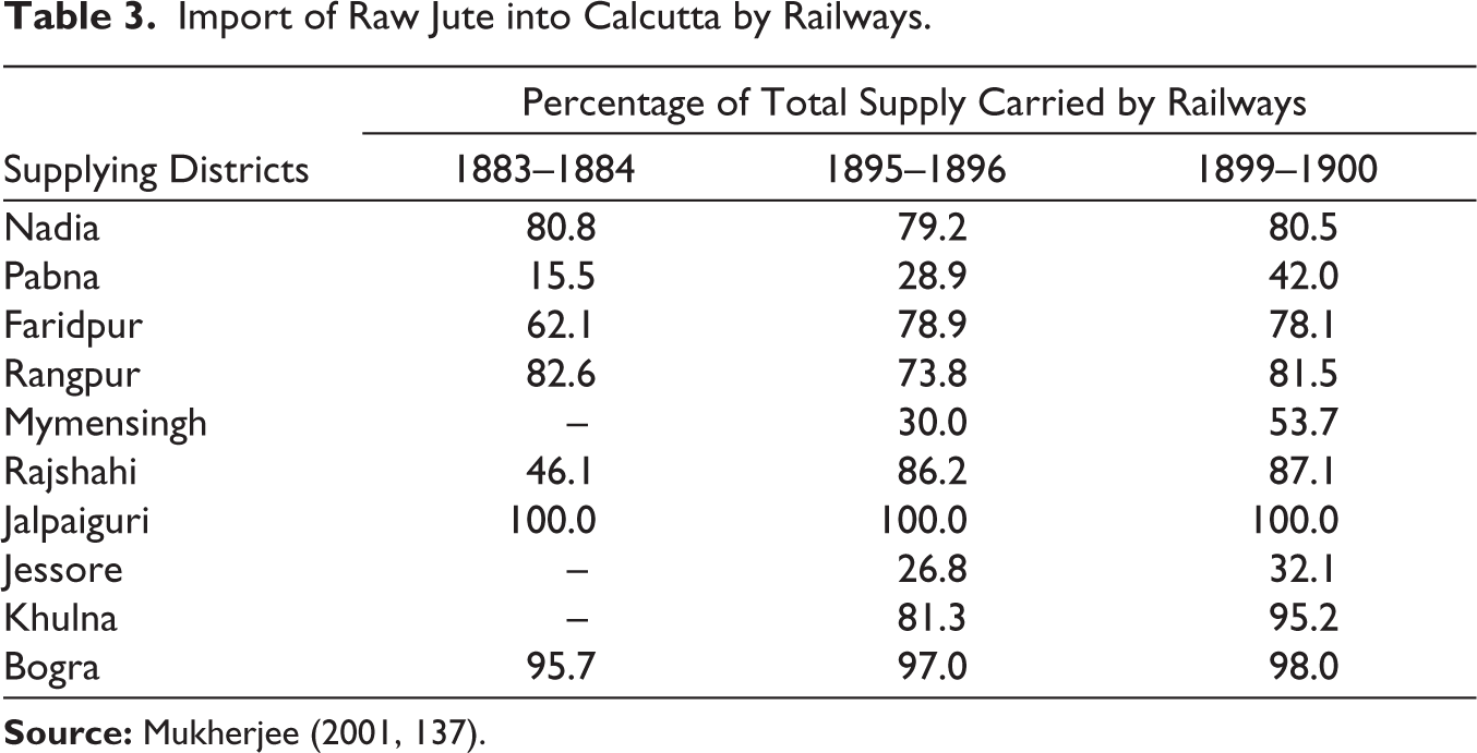
The first experimental railway line from Howrah to Hooghly was inaugurated on 15 August 1854, although its formal opening was delayed till February of the following year when the extension of the section up to Raniganj, the important coal-producing centre, was completed. 43 The selection of Howrah for the erection of the terminus station of EIR gave an impulsion to the industrial prosperity of the riparian stretch. Engineering firms and iron foundries were established, and they were closely followed by the erection of jute mills, cotton textile mills, cable factories, flour mills, etc. During the first decade of the twentieth century, Howrah station was renovated and remodelled after the formation of the joint terminus of EIR and BNR at Howrah station. The old station building had been made over the latter, where the EIR had constructed a large imposing building with six long platforms for trains; outside, a long row of godowns had been erected for the enormous goods traffic, especially in coal, wheat, rice and oilseeds which come to Howrah; quarters had also been built at Howrah and its suburb Bamangachi for European staffs. 44 To connect Khidirpur Dock, a branch line was constructed parallel to the river Hooghly, up to Shalimar. A considerable number of local trains started steaming from Howrah to Uttarpara to facilitate suburban passengers. Though from an administrative perspective, Howrah was an independent administrative body from Calcutta, but geographically, socially and economically, it had become an inseparable part of Calcutta. The EIR, BNR and EBSR evidently contributed to the economic development not only of Howrah and Calcutta but also of entire eastern India. They had been influential in harnessing the enormous agricultural as well as industrial prospects of the region by stimulating the collection, transfer and distribution of raw materials and finished products. Calcutta’s status as the jute hub of India, to a great extent, owes its existence to the system of railways (Table 3). The EBSR participated on a visible scale in the transportation of raw jute from the interior districts of eastern Bengal to the machines of Calcutta (Table 3), and very soon it dominated the other modes of transport in this regard on the grounds of frequency, convenience and reliability. Moreover, besides the visibly industrialised localities of Calcutta and Howrah, a considerable number of industries started mushrooming all along the railway tracks from Bally to Uluberia. In 1908, no less than 56 factories in Howrah district were registered under the Indian Factories Act (XV of 1881, amended by Act XI of 1891); in 1908, these factories employed 69,790 operatives or 8% of the total population of the district; the bulk of those factories was situated in Howrah town, only twelve being outside it. 45 The EIR and BNR had their engineering works in Howrah and Shalimar, respectively. Additionally, both companies had their own workshops for the construction and management of rolling stocks in Liluah and Howrah, respectively. In 1908, EIR’s Carriage and Wagon Construction and Repair Workshop had an average daily workforce of 5,097, and its Engineering Works had employed 313 operatives.
Import of Raw Jute into Calcutta by Railways.
Clearly enough, railways made a massive and tangible impact on the urban fabric of the city of Calcutta. Just like Bombay, in the case of Calcutta, railways also reshaped the urban morphology, directed the growth of the city and, of course, facilitated suburbanisation (Figure 2). There were many discrete residential areas, small towns and villages along both sides of the Hooghly River to the north of Calcutta, as far as Naihati on the east bank and Bandal on the west bank. Railways conveniently connected all these small settlement patches along both sides of the Hooghly River to Calcutta, leading to continuous urban development in the region. They tied up the whole great mass together. 46 At the same time, railways led to the expansion of the city towards the west. Before the introduction of railways, Howrah was nothing more than a village. But railway development and consequent formation of the terminus station at Howrah gave the area an impetus to grow. Following the EIR and BNR lines, the city started expanding towards the north and west, respectively. Similarly, Sealdah also attracted lots of commercial and residential developments. Thus, both Howrah and Sealdah became two nuclei that acted as the centripetal force, which in turn led to the rapid growth of the city.
Madras, another important colonial port city, began to notice its poison on the railway map of India in 1856. It was the terminating point of Madras Railway (MR) and South Indian Railway (SIR). The MR was on broad gauge and had three sections. Of these, the north-east section having its terminus at Royapuram connected Madras with Bezwada (Vijayawada); the north-west line from Madras Central Station, moved towards Bombay and the south-west line from the same station extended towards the West Coast of India. The SIR, which was on metre gauge, terminated at Egmore station, ran to Tuticorin. The Madras and South Indian Railways had a joint section on the Madras Beach, opposite the harbour, for the convenience of the shipping. 48 Later Southern Mahratta Railway also entered Madras Presidency to connect the Krishna and Godavari Deltas with Bombay via Bellary. Each of these railways played a distinctive role, the Madras and Southern Mahratta Railway (amalgamated form of MR and Southern Mahratta Railway) covered the states of Madras as well as Bombay and spatially tied them together by serving the north and south of peninsular India, while the SIR brought the states of Travancore Cochin and Madras together. 49 Thus, railways came in the form of infrastructural undertakings in Madras, intended to unite the city into a greater political-economic devise of territorial integration through its networks.
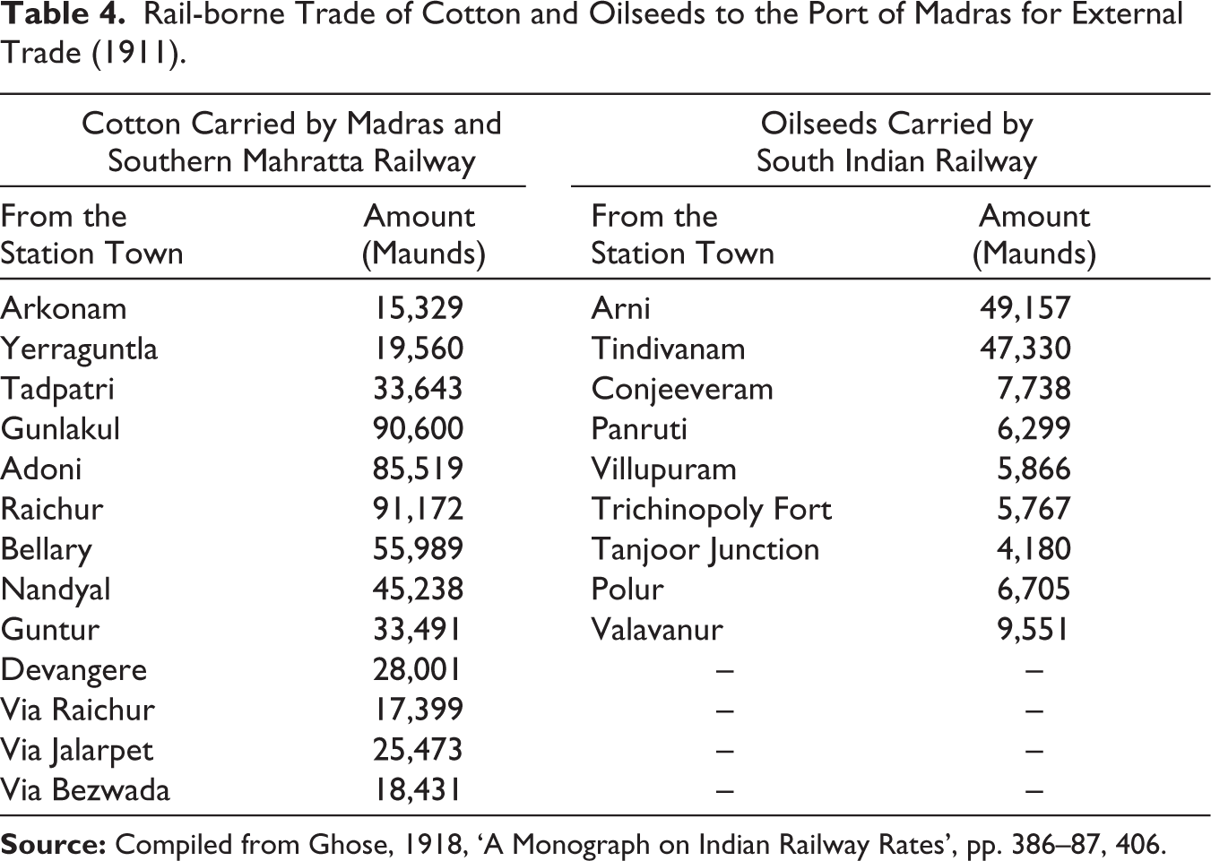
The expansion of the city of Madras had apparently quickened in the years followed the inception of railways, when railways shortly made it feasible to lead comfortably a suburban life, at a considerable distance from the city core (Figure 3). Along the railway lines and around the railway stations commercial activities and residential units started growing. The railway system expanded their range, amplified their frequencies and encouraged the growth of new ones too fluently that all distinguishing them, in accordance with an evidently fixed criterion, became almost impossible. The population started increasing very fast; in the year 1872 Madras was the home of 367,552 people, which was increasing by 509,346 in 1901. Thus, Royapuram, Tambram, Egmore, etc. became the major population and commercial clusters within the city. Here and there in the city, the railway companies shoulder public works, sometimes on their own or in cooperation with the municipal body that initiated a bonafide improvement of urban infrastructures. The stations, marshalling yards, sheds, signals, steam, diesel and electric locomotives, coaches, wagons, rail motors, steamers, telephones, wireless and telegraph equipment, powerhouses, workshops, printing presses 50 etc. provided a new dimension to the cityscape of Madras. With time railways had emerged as much necessary as roads, sewers or government buildings, to well-run the city. Certainly, the huge influx of rail-borne traffic was straight away an indicator of thriving trade and healthy circulation, although a reason of concern for local authorities like the municipal corporation. As the network of railways expanded, the city became inundated under immense goods traffic along with enormous volume of passengers, destined to and from the railway stations. This has evidently been increased after the 1880s when the railway system slowly began to dominate, but not replace, other modes of urban transport and there was an increasing preference for the usage of railway mode in terms of both goods (Table 4) and passengers. 51 Thus, all the three prime port cities of colonial India, Bombay, Calcutta and Madras, fit well with the argument and reasoning of Seema Sharma that

Rail-borne Trade of Cotton and Oilseeds to the Port of Madras for External Trade (1911).
In Europe, most of the railway stations are on the outskirts of the city. Goods and people would come and be carried into the city through other modes of transport such as roadways. In India, however, the railway stations were built in the heart of the city. Vast areas were and still are being used to construct stations, along with business centres to service the commerce concerned with the railways. The railways brought both the goods and customers to the city and gradually activity coalesced around the station and they became magnets for the developing city. Roads developed but only as feeders to the main transport hub’. 52
There were a sound number of Madras suburbs which flourished mainly as centres of industrial interest or of supplies upon which industries tend to rely upon. Perambur, a demographic nucleus next to the railway installations is the brightest name in this regard, which visibly directed the urbanisation process of Madras. A large railway workshop was founded in 1862 in Perambur, to serve the Madras and Southern Mahratta Railway Company. 53 It was a combined locomotive, coach and wagon building workshop. Naturally, Perambur attracted a huge volume of migrants towards the workshop and provided a new lustre to the city. Hence, railways and industries penetrated one another in Madras. They all were providers and purchasers, suppliers and consumers, borrowers and beneficiaries, alike. The interdependence among railways, industrialisation and suburbanisation needs to be constantly acknowledged if one seeks to get right insight into the question that what colonial railways did for the city of Madras. A lot more deeply and extensively than any other mode of transportation, railways permeated the entire economy of the city.
Railway Towns of Colonial India
Colonial railways had exercised their influence upon most urban settlements of India in some way, but the railway towns are unique in this respect since they owe their origin and growth as manufacturing centres and demographic clusters almost entirely to the system of railways and still depend, to a large extent, upon the later activity from the standpoint of employment. 54 However, historical inquiry and recognition of a specific category of town on the basis of occupational structures and employment statistics may be countered by deficiencies in data and evidence. Thus, occasionally, the definition of railway towns follows a largely subjective path, considering railways as the major force behind the origin and evolution of those towns.
Kharagpur
Kharagpur is one of the brightest names that can readily be designated as a product of colonial railways. Kashmir K. Koul, in his classic book (cum travelogue), demonstrated Kharagpur as really an output of the railway strategy of Bengal–Nagpur Railway, which later formed the parts of the South Eastern Railway Zone in independent India. 55 Kharagpur was an unheard name, devoid of any historical importance in the district of Medinipur (Midnapur) in Bengal Province. The last decade of the nineteenth century brought about a new revolution in the history of the area with the introduction of the Bengal–Nagpur Railway. 56 Kharagpur, which was 12 km away from the district headquarters, Medinipur, and 116 km away from Calcutta, was chosen as the appropriate site for the erection of a railway station, workshops and colonies. The availability of vast and cheap land was a lucrative factor behind the selection of the site. Soon after the opening of the Kharagpur Station in 1888, it became a junction in 1889, and by the end of the first decade of the twentieth century, it had become the centre from which railroads radiated in no less than four different directions, such as, in the east towards Calcutta, in the west towards Bombay, in the north towards Asansol and in the south towards Cuttack. The actual forethought was to serve the agricultural interest by transporting surplus agricultural products to the areas of deficit; however, with the realisation of the mineral wealth potential and consequent industrial prospect of the surrounding region, Kharagpur perhaps became a definite conviction of superiority. 57
Formation of the railway station in Kharagpur was closely followed by the development of the Railway Settlement Area and railway workshops. Secondary and tertiary employment facilities provided by the railway workshops and by the station, construction of quarters for railway employees and workers and consequent development of other infrastructural facilities, such as streets, markets, schools and recreational centres, led to a huge influx of migrants. The town started growing spatially and demographically. Soon it became evident that the town was largely headed up by the railway company, which either in its own right or through its auxiliaries had the lion’s share of the urban land under its control. By the year 1901, around 3,526 people were residing in the Railway Settlement Area, and the 1911 Census enumerated the population of the entire town as 18,957. Thus, Kharagpur was given the status of a ‘railway town’ by the Census of India, 1911.
The design of Kharagpur reflects the layout of railway colonies, designed during the 1860s, to accommodate European and Eurasian staff. The railway colony of Kharagpur stood distinctly from the adjacent unplanned bazars and settlements. On the south side of the railway station was the railway colony proper, consisting of a series of roads in a grid of six main avenues crosscutting with smaller roads; on the southernmost limits was the long street of widely spaced bungalows with large gardens for senior officers, so uncrowded and deserted was the area that it was known among lower-ranking employees as a night-time lovers’ lane. 58 Neighbouring these elite bungalows, there was an old ground of railway volunteers, where special employees were instructed and trained to defend the colony that is currently dealt with by the Railway Protection Force. The railway colony of Kharagpur had self-sufficiency in terms of water supply, cleanliness and sanitation. Nearly one-half of the railway workers were accommodated in the colony. Quarters were categorised under different ranks and were allotted to workers and employees based on their rank, status and salary levels. Most of the bungalows of the town followed British architecture, having large patios and precipitous, sweeping roofs. However, the residences for middle- and lower-income groups of employees and workers were planned in the barrack-style house, having two to three chambers with a patio encased by curved windows and Victorian ironwork. Moving northward back towards the station from this outer avenue, there was a sports track and arena, the Railway Institute, the Masonic Lodge and Protestant and Catholic churches. 59
Bhusawal
Being situated at the junction point of Nagpur and Allahabad branch of the GIPR, Bhusawal had become an active trading centre since the 1870s. Until the opening of this railway in 1863, it was an unimportant village in Sindhia’s territory, the property of a member of the Nimbalkar family. 60 Soon after the formation of the junction, trade increased considerably, a sub-judge’s court and a post office were developed, and the population had grown to 6,804 in 1872. Following the formation of the railway junction, Bhusawal had become an important nucleus with a large railway workshop and a sizeable European population. Very soon, Bhusawal appeared as the headquarters of Bhusawal division of GIPR. It was declared a municipality in 1882–83, with an area of 4.7 sq miles under the Bombay Municipal Boroughs Act.
Railways led to the amplification of the economy of Bhusawal by the construction of the workshop for repair works. The railway workshop at Bhusawal was truly large and contained running sheds and mending shops for Khandwa, Sheogaon and Nandgaon Railway Districts. Of 1,200 workmen who earned about ₹ 28,000 a month in wages, 100 were Europeans or Eurasians, almost all of them engine-drivers and mechanics; the rest were natives. 61 The considerable size of the railway employees had pulled a variety of retail businesses. The GIPR Company erected an adorable station and residences for its workers and employees. The railway station of Bhusawal was constructed in a hollow, around two miles away from the point where the branches of GIPR to Nagpur and Allahabad were diverging. The station and the workshop were built at a cumulative cost of ₹800,000, with sizeable refreshment halls and bathrooms, personable reading rooms, beautiful gardens and a gymnasium. In the year 1868, Bhusawal railway station transported 200,872 passengers and 4,056 tonnes of goods; the passenger traffic had increased to 369,775 by the year 1878. However, the goods traffic had shown a declining trend, that is, 1,955 tonnes in 1878. The chief import products were construction materials, milled cloth, iron and steel products, medicines, etc., most of which tend to come from Calcutta, Bombay and Nagpur. The export items mostly consisted of raw cotton, ghee, banana, groundnut and its oil, etc.
The water supply of the town of Bhusawal was based on the Tapti River, from which water had been lifted with the help of steam pumps and pipes. The water was driven up to a large tank in the gardens near the station, set on the top of a handsome two-storey building, the lower storey was in use as a billiard room and the upper as a railway library; in front of the tank house was a handsome fountain, near which the railway volunteer band used to play once or twice a week; outside of it, in the railway gardens, was a pavilion with a broad floor, which was much used for dances. 62 The entire railway premise was carefully surrounded by wire fences. The railway gardens and plantations of Bhusawal were planned in such a way that a formerly open country had become over-green with trees. Subsequently, the British Government had also planned a hospital, school, rest house, magistrate’s office, jail and Subordinate Judge’s Court, in suitable locations within the town.
Jamalpur
Located around 468 km north-west of Calcutta, on the loop line of the East Indian Railway, the town of Jamalpur is a bright formation of colonial railways. In 1862, the locomotive superintendent of the EIR Company, D. W. Campbell, determined to transfer the locomotive workshop of EIR from Howrah to Jamalpur in order to persuade better work ethics among British employees, including loco pilots, engineers, mechanics, as well as guards, because, reportedly, ‘during their working hours these men disappeared to pubs and billiard rooms of hotels and lodges spread across Howrah and Calcutta’. 63 Therefore, the labour pool would heavily rely on the railway company, and investing in the training for new railway engineering standards would not be wasted due to the loss of skilled workers to a growingly competitive market such as Calcutta. 64 Consequently, the site of Jamalpur was founded for the establishment of a locomotive and carriage workshop of the EIR Company.
Jamalpur neither had a convenient water supply, nor was it in close proximity to the coalfields or iron ores of Bengal and Bihar, but it had what was required the maximum: abundance of cheap, skilled labour. Jamalpur had a close propinquity to Monghyr (Munger), an important urban centre of eastern India during the seventeenth and eighteenth centuries. Later, the largest industrial establishment of the district of Monghyr was constructed around the railway workshop at Jamalpur. A considerable size of European population migrated to the town, who were mostly settled within the planned railway colony around the workshop. Thus, by drawing both from the expertise of skilled blacksmiths from nearby Monghyr and railway workers from the northern United Kingdom, Jamalpur came into view as a notable hub for a railway workshop in eastern India. 65
In Jamalpur, the railway company did everything and owned everything. The railway colony in Jamalpur was designed with neatness, consistency and geometric precision. There were a mechanics’ institute, a racket court, two Christian churches, recreation grounds, a library and a band, furnished with instruments from a tidy and voluntary fund, and in fact, every apparatus that could possibly contribute to the recreational needs of the men off work. 66 The workshop of Jamalpur covered an area of 99 acres and provided employment and accommodation to about 230 Europeans and 9,000 native mechanics and labourers. The average daily number of workers employed in 1906 was 8,797, the wages of the native workmen varying from ₹3 to ₹50. 67 With its large locomotive workshop, Jamalpur became headquarters of the Locomotive Department of EIR. It was constituted as a municipality in 1883 with a population of nearly 13,000, which increased by 18,089 in 1891, out of which the Europeans and Anglo-Indians did not account for more than one thousand. This indicates that the spatial expansion of the town essentially comprised the native residences and tenements despite the clear edict of the British Government that prohibited a vernacular market from blooming in close proximity to the station. However, the 1901 Census recorded the population of the town as 13,929. The decrease was chiefly due to many persons leaving the town on account of the plague which was raging at the time. 68 Though Jamalpur was a small town, the institutions and practices here had a fascinating similarity with what happened in railway towns of England and North America, where clubs, debating societies, lantern lectures, sports, churches and other social, recreational and educational activities had a shared and connected history. 69 Social life of the town was largely confined to the clubs and institutions.
The railways maintained a volunteer defence force (the Railway Volunteers) and it was a virtual condition of service that staff should volunteer to serve. They provided such sabre-rattling as might be necessary, but, apart from twice-weekly drill parades, their chief function was probably the dispensing of appropriate light music by their band in the evening and at week-ends. 70
To a large degree, railways not only shaped the physical morphology of the town but also visibly influenced the social lustre of the city. Following Rudyard Kipling’s observation, therefore, Jamalpur could truly be considered the ‘Crewe of India’.
Conclusion
The development and modernisation of transport infrastructure (roads and railways), as well as the development of energy supply and communication infrastructure, significantly affected settlement development. 71 British rule in India, and its grand imperial weapon, the railways, dramatically influenced the origin and development of modern India’s urban places not only as a mechanical instrument but also as a driver of social change. The system of railways was largely utilised by colonial authorities to generate and modify social space through the assortment of physical space. The initial trunk routes were lined up primarily between large cities and industrial districts. They ran directly, barring the places where the geographic barriers of the country imposed deviations. 72 However, with time the dendritic pattern of the railway network connected all the major port cities with their hinterland and with each other, which in turn helped to form a well-integrated national settlement system. Thus, the majority of the prominent cities prevailing before the advent of railways got additional benefits from the British colonial railways. Soon, they began to manifest the imprint of the railway system on their socio-spatial morphologies and cityscape. Smaller towns, avoided or bypassed by railway expansion, or which were included in the railway network much later, found themselves adversely affected. The railway’s focus on Calcutta, Bombay and Madras reinforced the colonial explorative interest of British rulers and accelerated the economic connection between India and Britain. At the same time, the development of some new railway settlements at some strategic points, around the railway stations and workshops, gave an impetus to the social and economic development of the country. Against this backdrop, the present article throws light on an alternative viewpoint of the interaction between railways and colonial urban history in which railways are typically treated as artefacts of urban change that sustain analytical weightages and plead for academic investigation in their own right.
The origin of railway settlements met the operational and logical requirements of the entire railway system. 73 These towns, which were the total creation of the railway companies, evolved as important economic and demographic nuclei over time and occupied significant positions in the network of urban settlements at the national and regional levels. As time elapsed, railways symbolised everything that they had, ranging from their identity to structure. Furthermore, at the intra-urban level, railways and associated infrastructures had a major influence on the land-use pattern and direction of growth of the existing urban places. The railway services acted like magnets, which attracted not only a large volume of the population but also a huge variety of social and economic institutions. Thus, it significantly affected the demographic size and social composition of the built environment of Indian towns and cities. Suburban railways, tram cars and city buses gave colonial cities a new status. 74 In each town, large or small, the economic base was affected by the fuller pursuit of specialisation which the cheap transport linkages made possible, and since the logistic problems of supplying towns with food, building materials, fuel, raw materials and labour were solved, a rapid rate of urban growth could be maintained. 75 Thus, railways literally induced a spatio-temporal restructuring of the urban centres of India.
Footnotes
Acknowledgements
We wish to express our deep gratitude to the late Professor Ravi S. Singh for his constructive ideas. This research is partly supported by the doctoral research fellowship (JRF/SRF) granted to Iman Banerjee by the University Grants Commission, New Delhi (ref no. 190510006296). Iman Banerjee is also a recipient of a Fine Postdoctoral Fellowship at the Technion, Haifa, Israel.
Declaration of Conflicting Interests
The authors declared no potential conflicts of interest with respect to the research, authorship and/or publication of this article.
Funding
The authors received no financial support for the research, authorship and/or publication of this article.