
Abstract
Architecture, landscape architecture and urban design are seldom merely benign aesthetic propositions. With its victory in the Spanish-American War (1898), the United States unexpectedly found itself in possession of an empire. Within a volcanic climate of patriotic fervour, Washington’s new imperial status galvanized interest in improving the city in a manner commensurate with its enlarged role. On the strength of his work at the World’s Columbian Exposition (1893), celebrated architect Daniel Hudson Burnham took the lead in Washington’s transformation (1901–2) and urban design became his medium for imperialist expression. This potent mechanism’s deployment would not be confined to the imperial hearth. The United States soon set its sights on modernizing, that is ‘Americanizing’, Manila, the antique capital of its newly-acquired Philippine colony, and similarly charged Burnham with the task (1904). Overtly emulating the British Raj in India, he was also to design a wholly new summer capital there. This essay canvasses Burnham’s work at the American and Philippine capitals, along with his vicarious hand in the design of a new model American town in the Panama Canal Zone, considering it through the lens of imperialism. The location and imperial purpose of these projects also reminds us that – at least from an antipodean perspective – in the early 20th century, Great Britain held no monopoly on empire.
Keywords
Imperial prelude
More than 120 years ago, in 1893, Daniel Hudson Burnham unveiled a miniature City Beautiful before an international audience at Chicago. Under his direction, the World’s Columbian Exposition and its White City had risen, mirage-like, on the shores of Lake Michigan. In jaw-dropping contrast to Chicago’s chaotic, soot-covered reality, Burnham drew from antiquity to formulate an urban vision in totality; one of harmony, unity and imperial grandeur. A set-piece Court of Honor lies at the exposition’s heart (Figure 1). This cross-axial terrace, demarcated with reflecting basins, gained spatial dimension from the enveloping, uniformly neo-classical buildings aligned along each of its axial armatures. The Court’s buildings, through their linear alignment, consistent cornice height of 18 metres (60 feet) and vertical mass, enclosed and directed lateral views, establishing spatial corridors. The east–west axis took the exposition’s administration building as its western terminus, with the domed structure (the only violator of Burnham’s height restriction as it was emblematic of ‘government’) also serving as a viewing platform. From here, the eye travelled east, following the aqueous corridor’s trajectory, past a monolithic, gilded allegorical statue of the Republic, through a backdrop peristyle colonnade and across Lake Michigan’s expanse to rest at the distant horizon – the nexus between the water’s shimmering surface and the blue dome of the prairie sky. The Court of Honor’s architectural source, one quite literally awe-inspiring, was not lost on at least one fair-going journalist. Writing some months after the exposition’s opening, Frederick Cook (1893), mesmerized, dubbed the ensemble a ‘City Beautiful’ (a very early use of the term) and enthused: ‘Reconstruct Athens as Pericles saw it! Restore the Rome of the Caesars! Renew the Carthage of Dido! Yet Chicago, the Chicago of 1893, whose material vauntings and untamed aspirations are the butt even of its own wits, presents a spectacle that outsplendors them all’. America had momentarily achieved urban, if not quite cultural, parity with the Old World.
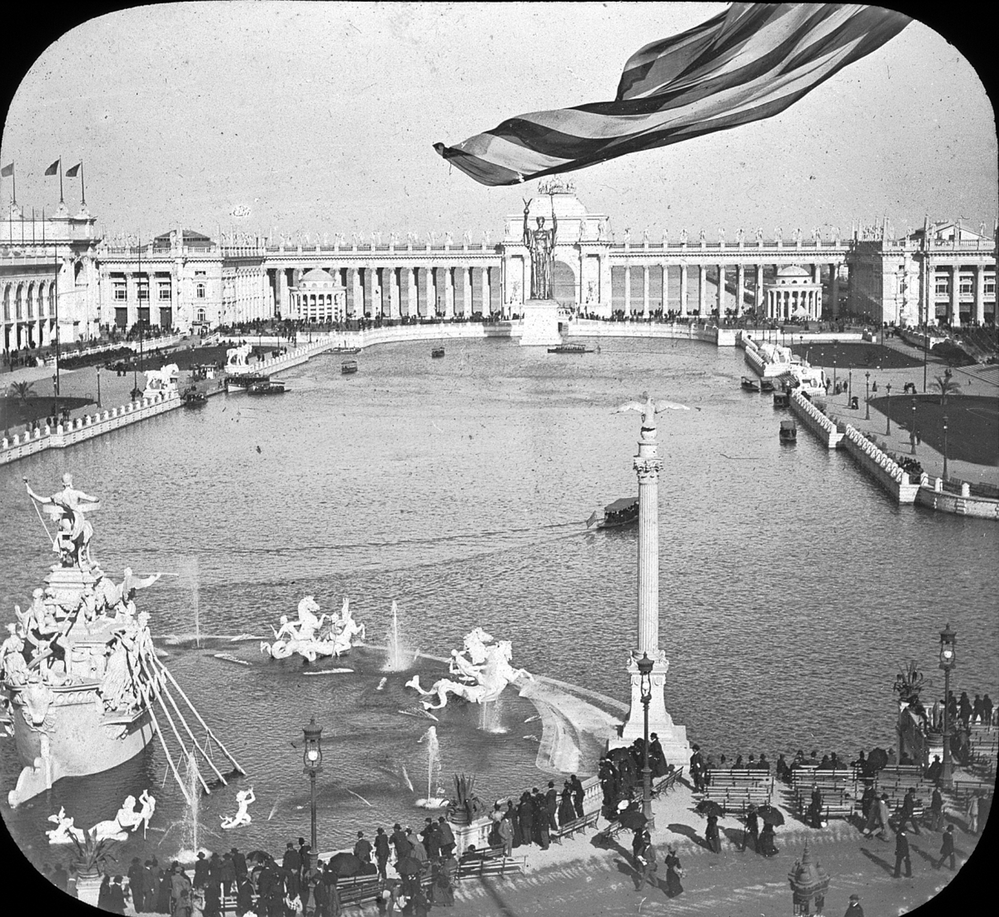
View from the Administration Building to the Court of Honor at the World’s Columbian Exposition, 1893. Available at: http://www.flickr.com/photos/brooklyn_museum/2784214063/sizes/o/) (accessed 8 October 2013).
Not all of the exposition grounds, however, evoked the heroicized ambience of imperial antiquity. North of the Court of Honor, the fair’s celebrated landscape architect Frederick Law Olmsted (then more nationally prominent than Burnham himself) created an oasis-like retreat. Unlike the White City’s excitement, intense animation and glare, this serene, green precinct featured a wooded isle, set amidst a lagoon. Foiling the geometry that otherwise typified the exposition grounds, here the planting was luxuriant, irregularly composed to create lush, exotic, tropical effects. When designing the island and its aqueous surrounds, Olmsted instructed his grounds superintendent ‘to make it appear that we found this body of water and its shores and have done nothing to them except at the landings and bridges’. 1 To achieve this effect, he desired the sinuous water body to be ‘rich, rank, luxurious, crowded with vegetation, like the banks of some tropical rivers’. On the face of it, Olmsted’s choice of a design source is a perplexing one. That he possessed a transcendentalist esteem for tropical nature, however, makes his selection fathomable. Olmsted’s preoccupation with the tropics originated some 30 years earlier, the outcome of his traverse across the Isthmus of Panama (en route to California). Panama’s ‘scenery’, he later mused, ‘excited a wholly different emotion from that produced by any of our temperate-zone scenery, or rather it excited an emotion of a kind which our scenery sometimes produces as a quiet suggestion to reflection, excited it instantly, instinctively and directly’. 2 ‘If my retrospective analysis of emotion is correct’, he concluded, then ‘it rests upon a sense of the superabundant creative power, infinite resource, and liberality of Nature – the childish playfulness and profuse careless utterance of Nature’. Still under a tropical spell in the 1890s, the impact of his Panamanian experience had proven lasting. For Olmsted, contact with an idealized, superabundant natural world remained a requisite quality of urban life – even in the futuristic White City. And, it is difficult to believe the landscape architect did not discuss his ‘tropical design approach’ with the fair’s Director of Works. Although he did not know it then, Burnham would later find himself ‘modernizing’ a city in the actual tropics.
At the World’s Columbian Exposition, architecture and landscape were, ultimately, continuous and intimately linked. Visitors to the fair, Burnham believed, ‘discovered the art of Landscape Architecture and were delighted’. 3 One of those who did so was Walter Burley Griffin, later co-author of Australia’s national capital, Canberra. His fair excursions lingering in his memory nearly two decades later, Griffin enthused that Burnham’s ‘restriction’ of buildings ‘to one colossal scale and single type of design around a rigidly formal, enclosed court produced an impression outliving those of all subsequent experiments, or of perhaps any architectural ensemble of modern times’. 4 Indeed, even before the fair closed, a South Australian newspaper had sensationalized Burnham as having ‘solved the greatest architectural problem ever presented’ ( Border Watch 1893).
Although the fair’s contribution toward fuelling the formation of the City Beautiful movement has long been recognized, its impact on the American urban scene was not immediate. Indeed, writing nearly three years after the event, Universalist minister John Coleman Adams (1896: 3) contended that ‘one whole aspect of the Exposition [had] received too little attention’ in the interim. ‘Nothing in any of the exhibits within the walls of those great buildings, illustrating the achievements of human skill and power’, he wrote, ‘was half so interesting, so suggestive, so full of hopeful intimations, as the Fair in its aspect as a city by itself’. Adams’ article was symptomatic of a larger phenomenon then at work. Around the time he penned his essay, movements in municipal art, civic improvement and outdoor art, up until then discrete, had begun to cross-fertilize and would soon produce the hybrid City Beautiful (Peterson 1976). In 1898, for instance, New York architect Charles Lamb (1898: 72) urged the unification of the varied improvement interests, believing the syncretic outcome would be the ‘dream of the Idealist, the City Beautiful’. In 1899, urban reform journal Municipal Affairs (vol. 3, issue 4) subtitled and devoted the contents of its December issue to ‘The City Beautiful’, entrenching the moniker (Peterson 1976).
It was 1899 that also saw one of the first reappearances of the World Columbian Exposition’s readily understandable architectural idiom, not in Chicago but in New York City (Brody 2010; Klare 1969). That year, acting upon Lamb’s suggestion, the New York-based National Sculpture Society erected a triumphal arch in Madison Square to welcome the return of Admiral George Dewey, hero of the Battle of Manila Bay (Figure 2). Whether consequence or coincidence, the Dewey arch resonated with the exposition in three aspects. First, like the fair’s structures, it was a temporary installation constructed of staff. Second, the arch’s design was similarly derived from classical antiquity; more precisely, its model was an imperial one, the arch of Titus at Rome. Lastly and most notably, as with the White City’s design, the arch was not conceived as an isolated object; its position within New York’s broader urban fabric was well considered. Located so as to become the ‘focal point of a vista that extended from several radiating avenues’, the arch was ‘visible from Washington Square to Central Park on Fifth Avenue, from Herald Square to 10th Street on Broadway, and from the East River to the Hudson on 24th Street’ (Bogart 1989: 103; Brody 2010). Although the Dewey arch was short-lived, the City Beautiful movement that produced it would soon gain momentum and national prominence (Wilson 1989).
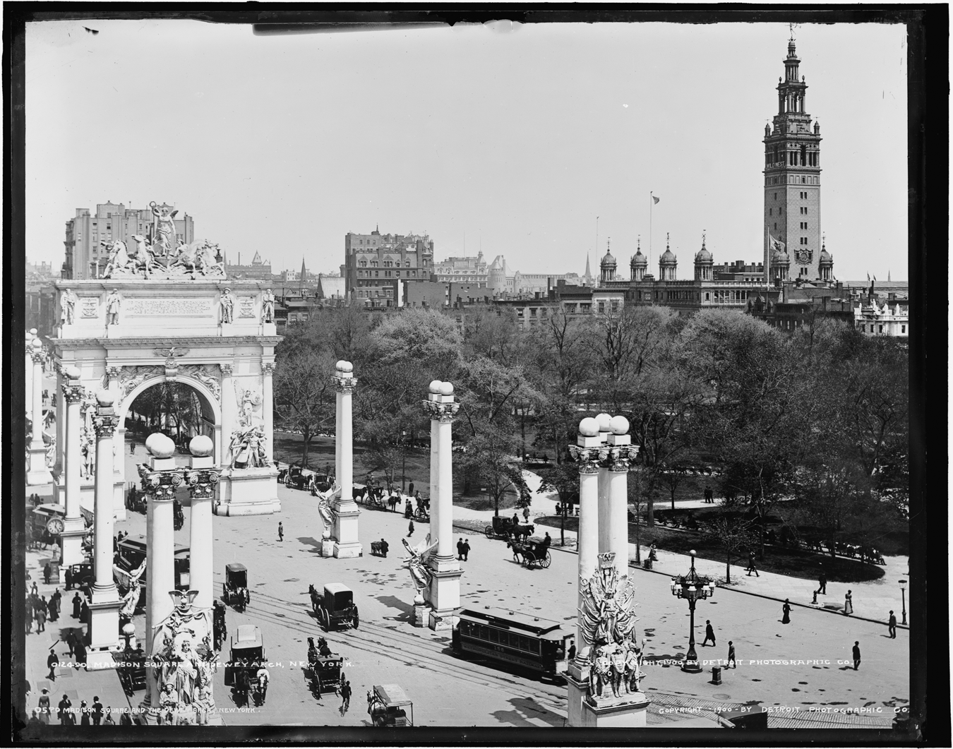
‘Madison Square and Dewey Arch, New York, NY’, 1899 (Library of Congress, Prints and Photographs Division, Detroit Publishing Company Collection).
Imperializing Washington, DC
With its victory in the Spanish-American War, the United States unexpectedly found itself in possession of an empire. Within a volcanic climate of patriotic fervour, at once frenetic and jubilant, Washington’s new imperial status galvanized interest in improving the city in a manner commensurate with its enlarged role. 5 In 1901, Senator James McMillan convened a new US Senate Park Commission to orchestrate the task, appointing Burnham its chair. He was joined by landscape architect Frederick Law Olmsted, Jr (Olmsted Sr’s retirement and failing health precluded his participation), fellow architect Charles F McKim, and sculptor Augustus St. Gaudens (Koehler 2006; Moore 1902a: 8–9). Burnham was awarded his prestigious position largely owing to his managerial success with the World’s Columbian Exposition. Actually, the commission’s formation amounted to a reunion of sorts: all of its members had contributed to the Chicago Fair. Now the coterie was charged with the restoration and expansion of Pierre Charles L’Enfant’s 1791 foundational plan for the national capital.
Far removed from the iconic urban landscape with which we are familiar today, Washington then registered not L’Enfant’s but the romantic, picturesque vision of pioneering American landscape gardener Andrew Jackson Downing. At President Millard Fillmore’s direction, Downing prepared a revisionist ‘Plan Showing Proposed Method of Laying Out the Public Grounds [today the Mall] at Washington’ in 1851 (O’Malley 1991). 6 Downing’s plan was implemented through time and, by 1901, instead of L’Enfant’s open Capitol vistas (west from the Capitol and south from the White House), Washington’s public grounds remained adorned with a sylvan mantle of meandering groves camouflaging the original plan’s spatial clarity (Figure 3). As Burnham was now poised to restore the foundational plan, an overview of the Frenchman’s design enables one to better discern the extent and scope of the commission’s revisions to it.
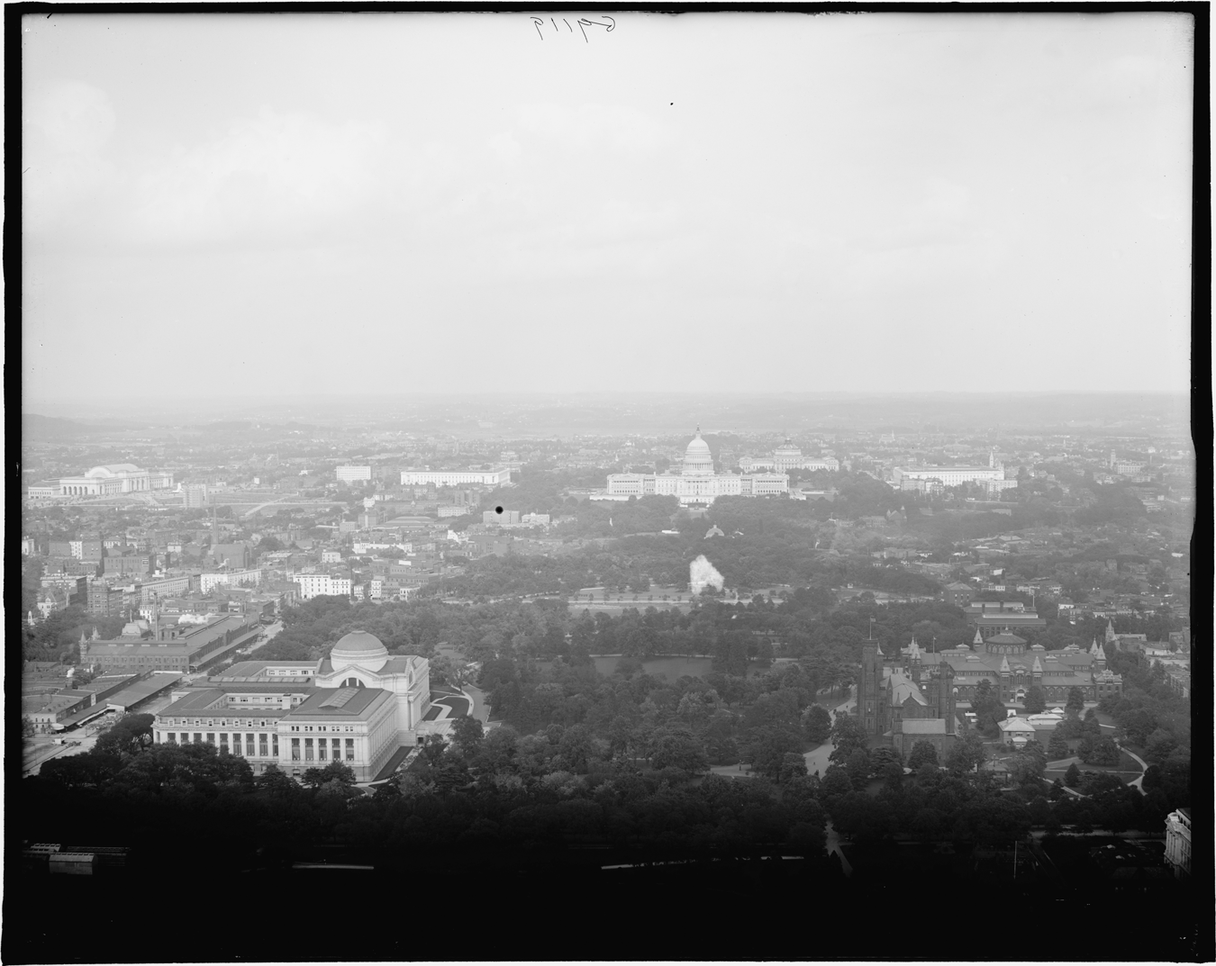
‘The Capitol from the [Washington] Monument, Washington, DC’, c.1910 (Library of Congress, Prints and Photographs Division, Detroit Publishing Company Collection).
L’Enfant’s layout is conventionally categorized as a Baroque plan, derived from André Le Nôtre’s royal gardens at Versailles (1661) – a somewhat pedestrian view apparently held by the commission itself. 7 L’Enfant’s design, however, was far from simply a mechanistic exercise in geometric abstraction. In fact, it encapsulated a nuanced response to the future capital’s physical site. Although almost unimaginable today, in the late 18th century the locale was distinguished as one of diverse picturesque beauty – a mosaic of ‘hilly and level, wet and dry, forested and cultivated, rocky and fertile’ (Hawkins 1991: 11). Indeed, many period accounts ‘extolled the unusual natural beauty of the area and L’Enfant was particularly sensible of its grandeur and variety’ (Scott 1991b: 37). After experiencing the site at first-hand, the architect himself diagnosed: ‘Nothing can be more admirably adapted for the purpose [of the federal city]; nature had done much for it, and with the aid of art it will become the wonder of the world’. 8 In L’Enfant’s urban vision for the new American capital, the natural world would be artfully accentuated, not subsumed.
When conceptualizing his layout, L’Enfant sought to reconcile a geometric template with the site’s undulating topography. The architect first strategically positioned government edifices and monuments on elevated sites or public squares ‘commanding’, as he put it, ‘the most extensive prospects’. 9 These were then linked with diagonal boulevards, enabling not only physical communication but also, again in L’Enfant’s words, ‘reciprocity of sight’. 10 Having established these reference points or anchors, he overlaid them with an irregular street grid, configuring it so that the orthogonals and the diagonals converged at the squares (Scott 1991a). At the epicentre of L’Enfant’s plan lay a rotated ‘T’-shaped parkland of sorts, its form the outcome of two interlocking axes – one north–south and the other east–west. Crucially, he awarded landscape foci to both armatures of his cross-axial composition, fixing its alignment in response to landforms and potential views. From the hill-top Congress House (now Capitol), L’Enfant projected an axial Grand Boulevard (today the Mall) westward, leading the eye down the greensward, past a diminutive equestrian statue of George Washington (not a monumental obelisk, as later realized), and then across the Potomac’s ‘middle ground’ waters to finally rest on the more distant ‘wilderness’. 11 Although aesthetically indebted to the picturesque, this sceno-graphic landscape appropriation was symbolically potent. Then, the continental interior was perceived as a pristine, superabundant, and seemingly limitless frontier, one beckoning the fledgling democracy’s expansion westward, an enterprise it soon considered to be its Manifest Destiny. In turn, from the elevated President’s House (today the White House), L’Enfant’s cross-axis extended south some 11 kilometres (7 miles) (terminating, on paper at least, at one of the cornerstones of the District of Columbia itself) and culminated with an aqueous prospect, the convergence of the Potomac River with its Eastern Branch (today the Anacostia River). And, ‘L’Enfant recognized that he must not sacrifice that vista to any architectural arrangement’ (Dougherty 1974: 33). By awarding landscape primacy in his cross-axial strategy, L’Enfant ultimately valorized America’s natural world.
After undertaking considerable historical analysis (which even included making a European study tour), the Senate Park Commission officially presented its new plan for the capital, also known as the McMillan plan (named after the commission’s congressional sponsor), in 1902 (Figure 4). Most fundamentally, the new layout emphatically underscored that in ‘L’Enfant’s day, the political and architectural allusions had been to republican Rome’ – now, however, the ‘rhetoric and rationale were unabashedly imperial’ (Hines 1991: 96). Despite its mandate to restore L’Enfant’s foundational layout, the commission made significant departures from it. Of these deviations, its proposal to disassemble L’Enfant’s sophisticated landscape optics was the most prominent. Eschewing his axial foci, the commission instead closed L’Enfant’s vistas, replacing their landscape termini with built objects. A memorial to Abraham Lincoln, envisaged, predictably, as a Greco-Roman temple, was now to anchor the western end of the east–west axis. Similarly, a ‘Pantheon’ accommodating statues of ‘illustrious men of the nation’ or ‘the memory of some individual’ (later realized as the Thomas Jefferson Memorial) usurped the Potomac as the southern terminus of the north–south axis (Moore 1902a: 50). Ultimately, in the new plan, L’Enfant’s open, expansive Grand Boulevard metamorphosed into a spatial corridor, a tapis vert. It was to be defined and accentuated, as at the Court of Honor, with neo-classical public edifices and flanking tree plantations aligned along both of its sides, becoming a linear courtyard of sorts. Eventually, with the McMillan plan’s incremental implementation, ‘all sense of the surrounding countryside [was] sacrificed to Federal monumentalism’ (Dougherty 1974: 36). 12
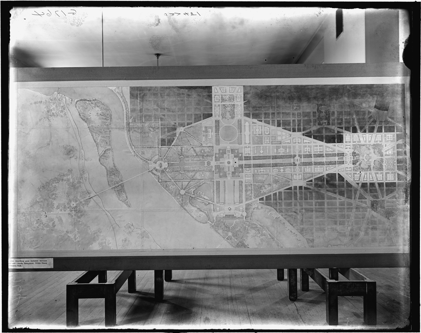
‘The future Washington, general plan, Washington, DC’, 1902 (Library of Congress, Prints and Photographs Division, Detroit Publishing Company Collection).
The McMillan plan’s spatially transformative monumentalization can be seen as symbolically underscoring the passing of America’s frontier, one Frederick Jackson Turner famously declared closed at, aptly enough, the World’s Columbian Exposition.
13
Instead, the Pacific now beckoned as America’s new expansion frontier. Seeing through what he believed to be an ‘Imperial façade’, critic Lewis Mumford (1924: 141–2) appreciated the gravity of the new plan’s symbolism. Writing shortly after the Lincoln Memorial’s completion (1922), he mused: The America that Lincoln was bred in, the homespun and humane and humorous America that he wished to preserve, has nothing in common with the sedulously classic monument that was erected to his memory. Who lives in that shrine, I wonder – Lincoln, or the men who conceived it; the leader who beheld the mournful victory of the Civil War, or the generation that took pleasure in the mean triumph of the Spanish-American exploit, and placed the imperial standard in the Philippines and the Caribbean? [the group is] represented as on their way with axes to make a ‘clean-sweep’, as they proclaim, of all the grand old trees on the Mall. They are costumed in architectural straight lines. Architect McKim heads the party. He is blowing a big horn – his own. He also has a big head. […] In the rear are men bearing a great number of tubbed trees [their canopies depicted as having been sheared into cube-like shapes] intended to replace the big trees destroyed. For further particulars inquire within.
Beyond the horrors of ‘butchering nature’, the protest was not simply the outcome of an aesthetic clash; the outcry had another more fundamental, albeit implicit, political dimension. Beginning in 19th-century America, picturesque landscapes – both naturally occurring as well as designed – came to be seen as emblematic of wilderness (but a memory in the Old World) and, in turn, American democracy (e.g. Marx 1964; Nash 1967). Indeed, the Washington Monument, for instance, was deliberately positioned asymmetrically off-axis – a decision motivated by a picturesque landscape aesthetic (Scott 1991b: 51–3). This was another optical effect the McMillan plan dismantled. 15 Alternatively, landscapes configured with regular, geometric layouts, especially at an expansive urban scale, were associated with European autocracies – as registered, for instance, by the inclusion of the name of King Louis XIV’s landscape gardener in the cartoon’s title (curiously, for cartoonist Berryman at least, Le Nôtre needed no introduction) and the potted topiaries in the image itself. And, this association may well have underpinned Downing’s decision to revise L’Enfant’s layout half a century earlier. As the furore enveloping the McMillan plan suggests, the picturesque’s American and democratic connotations apparently remained potent in the 20th-century’s opening decade. Nonetheless, the Senate Park Commission turned a ‘deaf imperial ear’ to the protest, and Washington as we know it today is largely the outcome of its plan.
Outposts of empire: Manila and Baguio
Americanizing Manila
On 8 September 1904, the front-page headlines of a newspaper in Daniel Burnham’s Chicago trumpeted: ‘Plan Queen City for the Far East: Uncle Sam Commissions Architect Burnham of Chicago to Make Manila the Gem of the Orient: Plan a Summer Capital: Spot in Mountains to Be Made the Philippine Simla [today Shimla]’ ( Chicago Daily Tribune, 1904). ‘It is seldom’, the newspaper sensationally enlarged, ‘that such an opportunity comes to make a “city beautiful”, but the opportunity lies waiting in the orient, and the government proposes to take advantage of it’. Burnham was now to ‘modernize’, that is ‘Americanize’, the centuries-old – and, by American (and Australian) measures, antique – city of Manila, capital of the United States’ newly-acquired Philippine colony. There, he was also to design a wholly new summer capital, Baguio. Still riding the wave of his Senate Park Commission success, Burnham was a logical choice for the job. 16 Indeed, the Philippine city building enterprise had been in the government’s imperial ether at least since 1901, when Burnham, the Tribune explained, was ‘president’ of the ‘Washington commission of architects’. ‘For the first time in our history’, a Chicago-based professional journal later boasted, ‘a private architect has been engaged to design public buildings and grounds in a distant territory’ ( Inland Architect and News Record 1904).
The Chicago Tribune also surveyed the newly acquired spoils Burnham was now charged to renovate and expand. The ‘elements of this puzzle’, the newspaper clarified, ‘consist of the old or “walled city” [known as the Intramuros], in which are situated the cathedral and the palace, and the outer or modern city, which is divided between the Europeans, Chinese, and Filipinos’. The city’s urban fabric was not limited to streets and buildings; it also contained, for instance, the Paseo de la Luneta (known commonly as the Luneta) (Plaza of the Lunette, in English), fronting Manila Bay. The Tribune distinguished this ‘fashionable driveway and park’ as Manila’s ‘only attempt at landscape architecture’. Ultimately, the scale and scope of the work Burnham was to undertake mandated assistance, and he conscripted fellow architect Peirce Anderson for the job; it also demanded the pair voyage to the Philippines (Hines 1974a; Moore 1921).
Disembarking at Manila in December 1904, Burnham found himself immersed in an exotic landscape of tropical nature, a world far removed from Chicago and its level prairie hinterland. The experience must have been at once ethereal and, perhaps, even somewhat foreboding for him. In early 20th-century America, as in Great Britain, conventional wisdom held tropical climes as sinister, disease ridden and home to primitive, indolent natives (e.g. Stepan 2001). In short, for some, the tropics were anathematic to civilization. Although Burnham was certainly not oblivious to this view, there is nothing to suggest he embraced it; his position was likely an ambivalent one. We do know that he did not dismiss the tropics as simply an obstacle to be overcome. Indeed, Burnham would soon judge Manila’s luxuriant setting to be ‘unparalleled and priceless’, an assessment glowingly resonant with his friend Olmsted’s esteem for tropical nature (Burnham and Anderson 1906b: 635).
Manila’s cultural landscape enchanted Burnham no less than did its tropical setting. To more fully appreciate his favourable response to Spanish Manila, one must remember that, by contrast, Burnham’s Chicago remained a ‘tumultuous place, building and rebuilding itself so fast that at times it must have seemed the entire city was under construction.…[It was] where travellers went to view the future’ (Bruegmann 1997: 3). In stark contrast to Chicago’s ephemerality or ‘perpetual youth’, Manila’s centuries-old Spanish mantle lent the city a palpable patina of antiquity and permanence. Burnham found the tropical Spanish architecture, doubly exotic to American eyes, to be ‘unusually pleasing’ (Burnham and Anderson 1906b: 627). He did not, however, explain precisely why he believed the pleasure he derived from them to be unusual; perhaps the buildings’ exoticism accentuated their allure. Beyond valuing these structures as picturesque archaeological curiosities, he assessed Spanish churches and government buildings as offering object-lessons for ‘future structures’ (at least for, as we will see, non-governmental ones), owing to their ‘practical suitability to local conditions’ (Burnham and Anderson 1906b: 627).
Along with individual buildings, even the broader urban tapestry of the Spanish city appealed. Burnham distinguished ‘the existing well shaded narrow streets’, for instance, as ‘picturesque’ and urged this character be conserved (Burnham and Anderson 1906b: 627). Of Manila’s Spanish architecture, Fort Santiago’s walls were the most prominent and brooding presence within the city’s urban landscape (Doeppers 1972, 2009). Prior to Burnham’s Manila involvement, calls were made to demolish them as some believed the walls impeded traffic, commerce and ventilation. In 1903, after much controversy locally and even back home in the United States, the government intervened and mandated the walls’ preservation ( New York Times 1903a, 1903b). Burnham, given his esteem for Spanish architecture, would probably have retained the ancient relics as well, had the decision been his to make; there is no evidence that he ever sought to overturn the government’s verdict. At least superficially, he thought the walls would ‘come in nicely for decorative purposes’ (Burnham 1906: 7). Retaining the walls, however, was not merely a matter of civic embellishment. For Burnham, the walls’ ‘imposing appearance’ gave them ‘great monumental value’, and by absorbing them into his new plan he appropriated their atmospheric antiquity (Burnham and Anderson 1906b: 630). 17 This, in turn, symbolically localized and legitimized the American colonial, if not imperial, presence and disguised its novelty.
Beyond the city’s walls, Burnham directed his professional gaze to the Paseo de la Luneta and soon learnt that it was far more than simply a parkland; the Luneta also played a vital role as the city’s social hub. It was the place where, as Helen Taft paraphrased her husband William’s (then Governor-General of the Philippines) description of it, ‘there were bands in the bandstands and that everybody in the world came and drove around and around the oval, exchanging greetings and gossip, while the children with their nurses played in the sand on the narrow beach’ (Taft 1914: 98). By the time Burnham called at the park, however, the size and number of docks had markedly increased and now, he diagnosed, ‘interfer[ed] with the view of the bay’, the Luneta’s ‘principal attraction’ (Burnham 1906: 8). This circumstance, he believed, ‘necessitates filling in a portion of the Bay and bringing the Luneta out to its former relative position [i.e. waterside]’ (Figure 5). Burnham’s decision to create a New Luneta confirms that he, like Taft, appreciated the original’s significance, assessing: ‘the existing [L]uneta plays such an admirable role in the social life of Manila that its advantages should be preserved unchanged’ (Burnham and Anderson 1906b: 628). This is precisely what he did. The New Luneta was laid out, as Burnham instructed, on reclaimed land to an elliptical form evocative of its Spanish counterpart. Like its predecessor, it took Manila Bay as its aqueous focus and similarly featured a bandstand. 18
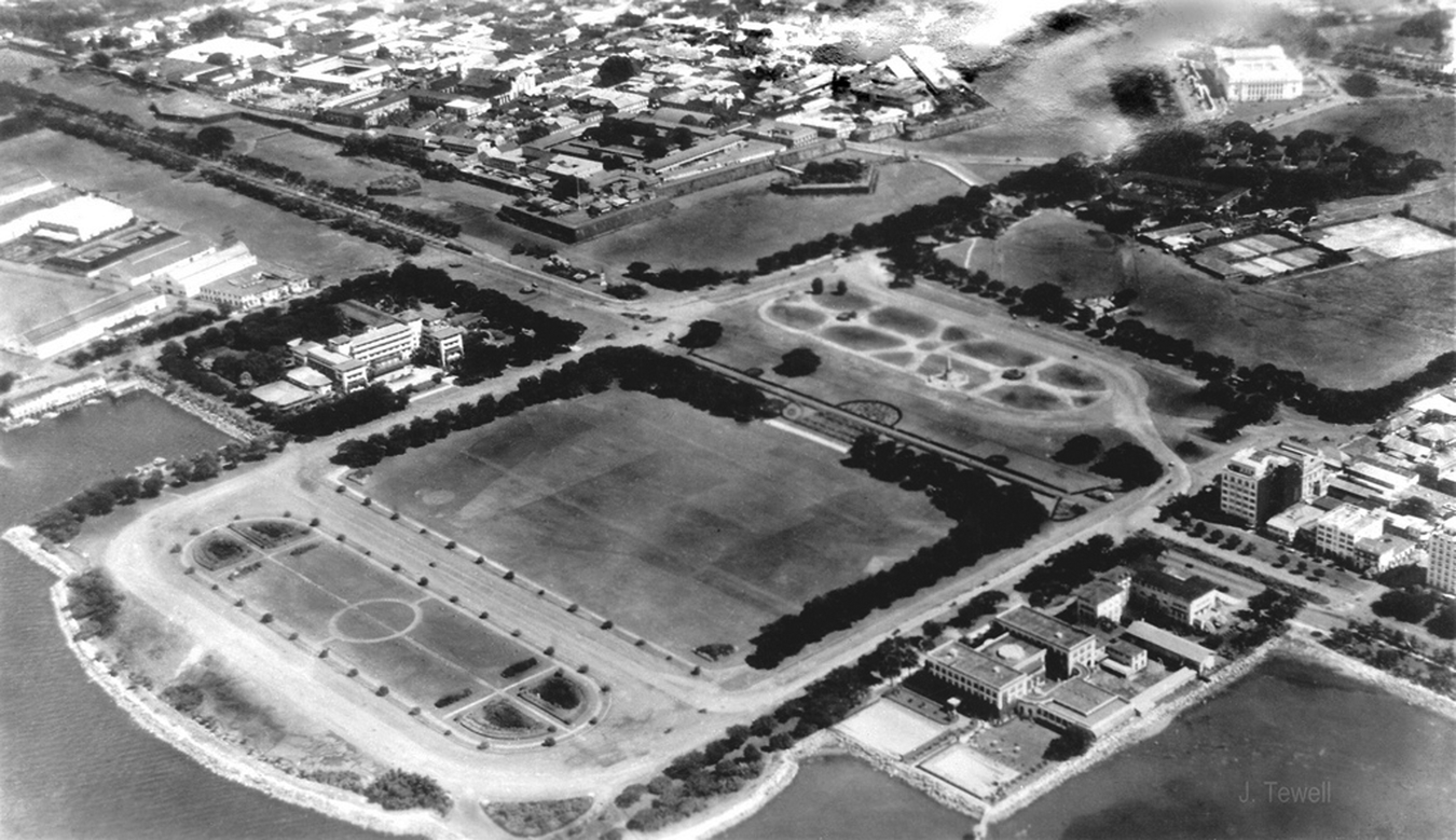
Aerial view of the New Luneta, c.1930. Available at: http://www.flickr.com/photos/johntewell/5200263761/) (accessed 8 October 2013).
Nearby the Luneta, again leaping the ancient city walls, Burnham proposed a new National or Government Group at their outskirts (Hines 1974b; Lico 2008). This inevitably neo-classical ensemble included, first and foremost, a domed Capitol, reminiscent of its Washington counterpart; this visual affinity, of course, was not accidental. The Group also featured a Hall of Justice, library, museum, exposition buildings and a post office. ‘Grouping itself [i.e. the array of buildings] closely about the Capitol at the center, it forms a hollow square, opening out westward toward the sea’ (Burnham and Anderson 1906b: 632). ‘The gain in dignity by grouping these buildings in a single formal mass has dictated the arrangement’, Burnham explained, ‘the beauty and convenience of which has been put to the test in notable examples from the days of Old Rome to the Louvre and Versailles of modern times’. Taking the Government Group’s eastern side as an epicentre, from there he projected a series of new radial avenues in the extant urban fabric, enabling ‘every section’ of the city to ‘look with deference toward the symbol of the nation’s power’. On the Government Group’s western side, Burnham projected an axial parkland corridor, taking the Capitol’s dome as its centreline, to physically and visually link it with the seafront Luneta – effectively creating a Philippine variant of Washington’s Mall (Figure 6). Indeed, the Luneta extension, like its American counterpart, was carpeted only with turf, ‘so as to give an unobstructed view of the sea [from the Capitol]’ (Burnham and Anderson 1906b: 628). This was a curious design manoeuver, given that only three years earlier at Washington’s Capitol, as we have seen, Burnham and the Senate Park Commission had proposed to effectively close L’Enfant’s axial ‘wilderness’ vista from the Capitol. Manila Bay, however, offered far more than just a beautiful prospect. It was, no less significantly, the site of Dewey’s naval victory and the birthplace of America’s empire. As such, the view compelled preservation and accentuation, from both an aesthetic and symbolic, imperialist stance. Having earlier dismantled L’Enfant’s Washington plan, Burnham now, somewhat paradoxically, reassembled it in Manila.
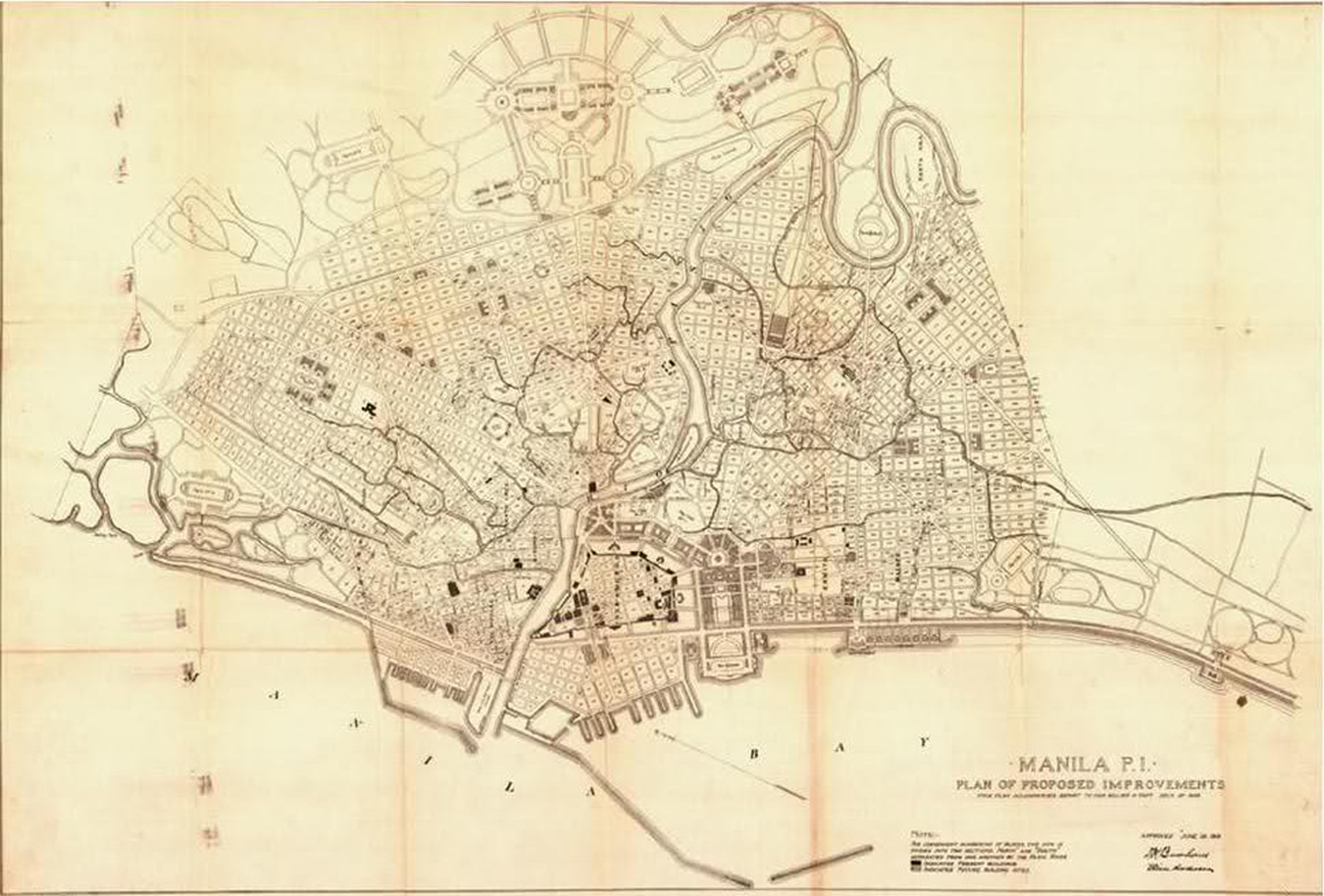
‘Manila, PI: Plan of Proposed Improvements’, 1905 (Avery Architectural and Fine Arts Library, Columbia University).
In the end, of all of Burnham’s revisions to Manila’s urban mosaic, his removal of the governmental presence from its walled Intramuros heart was of the greatest symbolic import. This extradition not only literally and physically distanced the American presence from that of their Spanish predecessors, it also emphatically proclaimed Burnham’s message that ‘the decrepit, oppressive rule of the Spanish, and all its articulations, was well and truly dispatched to history’ (Morley 2012: 14). Completion of Burnham’s new Government Group would take America one step closer to fulfilling its broader imperial agenda to assimilate, bind and ‘uplift’ the ‘primitive’, multi-ethnic Filipinos.
America’s Shimla
Although the idea of constructing a summer capital had originated with his predecessors, Burnham explained with American bravado: ‘it was always mañana with the Spanish rulers, and they never got around to actual work on realizing the dream’ ( Chicago Daily Tribune 1904). Taking a cue from their counterparts in British India, the Americans now set out to realize, according to the Tribune, a ‘Philippine Shimla’. At Baguio, unlike his earlier work at Washington and parallel transformations at Manila, Burnham would accentuate imperial monumentality not through grand ensembles of neo-classical architecture but by means of the configuration of the city itself.
So disparate from Washington and Manila’s intricate and constraining urban fabric, the future summer capital’s site was a tabula rasa. As such, it allowed Burnham to, in his words, ‘formulate [his] plans untrammelled by any but natural conditions’ ( Chicago Daily Tribune 1904). As he soon discovered, however, the site’s ‘natural conditions’ were formidable. Baguio confronted Burnham, otherwise more comfortably familiar with working on relatively level canvases, with a rugged terrain of topographical consequence. In response and in contrast to his growing repute for ‘thinking big’, if not bombastically, he rather unusually adopted the ‘controlling principle’ that his plan be ‘obedient to nature’ (Parsons 1915: 25). Adhesion to this tenet, however, did not preclude a formal layout. Burnham succeeded, quite remarkably, in nestling a neo-classical City Beautiful plan within the terrain’s warp and weft (Figure 7). Axes, for instance, were ‘developed along ridges, valleys and hilltops’ (Parsons 1915: 26). He effectively allowed landforms, not a predetermined template, to fix his layout’s geometric alignments.
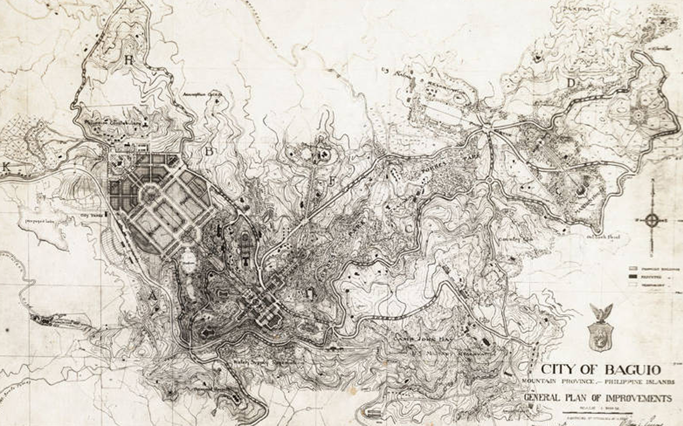
‘City of Baguio: General Plan of Improvements’, 1905 (Avery Architectural and Fine Arts Library, Columbia University).
Not unlike the topographical strategy L’Enfant employed at Washington, Burnham considered a pair of Baguio’s higher mounts to be pedestals beckoning governmental building ensembles. He allocated one summit to municipal government administration and the second to national; a ‘long main axis, expended by an open green esplanade’ linked the two hilltop groups (Burnham and Anderson 1906a: 405). ‘The intention is’, Burnham summarized, ‘to carry through the lines of the streets to commanding points on the hillsides and thus permit the location of monumental buildings where they command a view down neighbouring streets, and count for their full value as an important element in the general effect’ (Burnham and Anderson 1906c: 153). Crucially, he awarded visually commanding hilltops only to government buildings. Otherwise, to ubiquitously position ‘formal architectural silhouettes upon the summits of the surrounding hills’, Burnham cautioned, ‘would make a hard skyline and go far toward destroying the charm of this beautiful landscape’ (Burnham and Anderson 1906c: 155).
Alternatively, he advocated situating ‘buildings on the sloping hillsides’. There, they would ‘be seen against a solid background of green foliage’ and gain ‘the best possible setting without mutilating their surroundings’. By crowning summits with monumental government ensembles and subordinating all other buildings to the verdant slopes, Burnham ‘Americanized’ Baguio’s landscape. As the summer capital’s citizenry was largely to be American civil servants, Burnham’s governmental edifices no longer required a neo-classical architectural vocabulary; they were to be monumental in aspect, not in their architectural references. Consequently, Baguio’s buildings were constructed of timber, not stone, and in a fashion resonant with the American Stick style, Alpine-esque architecture of an ‘upstate New York resort town magically transplanted to this oasis of almost familiar weather and terrain’, if not Shimla itself (Robin 1992: 25) (Figure 8). The summer capital’s rugged topography, not its architecture, became Burnham’s medium for America’s colonial message (Sonne 2003: 93). At Baguio, the architect himself believed he had created ‘something unusual among cities’. 19
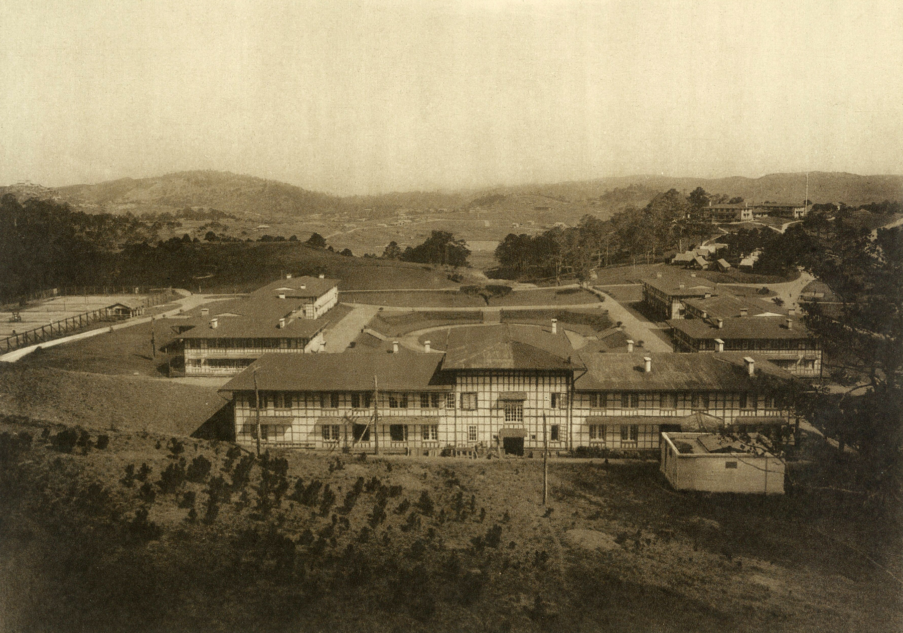
‘Government Center at Baguio — The Summer Capitol’, c.1915 (author’s collection).
Panamanian epilogue
The Philippines was not the only Pacific arena for American imperial city planning activity. The Hawaiian Islands, annexed by the United States in 1898, offered another theatre closer to the imperial hearth. In 1906, with the realization of Burnham’s visions for Manila and Baguio under way, journalist turned town planner Charles Mulford Robinson (1907) made a City Beautiful plan for the new American territorial capital of Hawai‘i, Honolulu (Ford and Warner 1917: 74–6). Apparently commissioned by the territorial, not national, government, Robinson’s plan for the city was more overtly decorative than imperial, at least superficially. 20 Nonetheless and in Burnham-esque fashion, he lavished attention on Honolulu’s administrative or governmental centre, perhaps responding to the city’s new status. Even further east from Hawai‘i and nearer to home, another imperial American city was about to rise in the Panamanian jungle.
Shortly after ascending to the office in the tragic wake of William McKinley’s assassination in 1901, President of the United States Theodore Roosevelt resolved: ‘No single great material work which remains to be undertaken on this continent is of such consequence to the American people as the building of a canal across the Isthmus connecting North and South America’. 21 The new president was determined to triumph where the French had earlier failed, to demonstrate American might, if not superiority. In 1903, having quickly ‘spoken softly and carried a big stick’, Roosevelt successfully (albeit not without heated contest) expedited Panama’s independence from Colombia. Later that year, the new republic recompensed, granting the United States perpetual rights to and sovereignty over a strip of land across the isthmus. This area, from then known as the Panama Canal Zone, took the canal as its centreline and was approximately 16 kilometres (10 miles) wide and 80 kilometres (50 miles) long (McCullough 1977).
Seven years later, in 1910, Roosevelt’s successor William Howard Taft established the Commission of Fine Arts – amongst other tasks, the new body was to advise on, most immediately, the McMillan plan’s implementation (Koehler 2006; Moore 1921). Predictably, Taft appointed Daniel Burnham its chairman. Although his health had begun to fail by then, the architect nonetheless accepted the post. Burnham’s friend Francis Millet joined him as the commission’s vice-chairman; the painter and sculptor had worked earlier with the architect as the World’s Columbian Exposition’s Director of Decoration. The other foundational members included fellow fair contributor and Senate Park Commission veteran Frederick Law Olmsted, Jr; sculptor Daniel Chester French; architects Thomas Hastings and Cass Gilbert, both unsurprisingly, neo-classicist in outlook; and layman Charles Moore, earlier the park commission’s secretary (and later Burnham’s biographer).
In 1912, however, the Commission of Fine Arts – now preoccupied with the Lincoln Memorial’s controversial design – received double blows. The first came in April. En route back to the United States from Rome, Vice-Chairman Millet tragically drowned with the sinking of the RMS Titanic. In an extraordinary coincidence, Burnham was at sea at the same time, bound for Europe on (‘thinking big’ again) the Titanic’s sister ship RMS Olympic. The two behemoths were to have passed one another midway across the Atlantic. At the anticipated passing time, Burnham attempted to send salutations to Millet via wireless, disturbingly without success. By way of explanation, Burnham was (somewhat surprisingly) informed of the disaster. In his 15 April shipboard diary entry, he lamented that as Millet’s name was absent from ‘the list of survivors’, he probably had ‘gone down, thus cutting off my connection with one of the best fellows of the Fair’. 22 ‘It will seem an empty world with no Frank in it’, he mourned in a letter (written around the same time) to fellow commissioner Cass Gilbert. 23 Burnham landed at Cherbourg five days later; although he was unaware of it then, he (like Millet) would never again return home.
Apart from its grievous personal impact on Burnham, the Titanic disaster was also, more broadly, of profound symbolic import. As Manieri-Elia (1979: 120–1) astutely discerned, the tragedy ‘seemed to portend the crisis of the world of Burnham and the “imperial city”’. When the Titanic, a ‘technological colossus’ and ‘floating City Beautiful’, he enlarged, ‘collided with an iceberg and was easily and inevitably overcome by a colossus of nature, the self-confidence of the Republican America of Roosevelt and Taft seemed to waver’. Twilight had descended upon the City Beautiful movement.
The commission’s second blow came in June, with Burnham’s death in Germany on the first of that month. The advisory body had lost its inaugural chairman and, at least for Chicago poet and critic Harriet Monroe (1912), ‘America [had] lost its Cecil Rhodes of [its] Art World’. President Taft, ‘greatly shocked’, publicly eulogized that it was he who had sent Burnham to ‘the Philippine Islands for the beautification of Manila and for the laying out of a capitol [sic] in the mountains in the fine climate of Aguio [sic]’ (Taft 1912). ‘There was no man in the professional life of the United States who has given more of his life to the public without having filled public office’, Taft grieved, ‘than Daniel Burnham’. Despite losing Burnham (and Millet), the commission persevered; it filled his vacant position with another imperially credentialed architect, Peirce Anderson. 24 Not without a degree of poignancy, the appointment of Burnham’s former Philippines assistant was made at Taft’s personal suggestion, possibly in tribute to the late architect. Anderson’s appointment, however, did raise professional eyebrows, simply ‘because he was known so little’ – Burnham had indeed left big shoes to fill ( Architectural Record 1912).
Balboa
In August 1912, only months after Burnham’s death, Congress passed the Panama Canal Act, a provision of which charged the Commission of Fine Arts (1913: 5) to advise it on the waterway’s ‘artistic character’. With the canal at long last nearing completion, the government could now indulge in the luxury of considering the herculean (and, for many, deadly) project’s aesthetic dimension. In February 1913, Daniel Chester French, now Commission Chairman, and Frederick Law Olmsted, Jr, were dispatched to the Canal Zone. 25 One suspects that the government’s ‘artistic’ Panamanian plans were already in the commission’s ken before Burnham’s death; whether or not this was the case, he would, nonetheless, have a vicarious Panamanian presence. After touring the Zone and consulting with their fellow commission members back home, French and Olmsted concluded: ‘The canal, like the Pyramids or some imposing object in natural scenery, is impressive from its scale and simplicity and directness. One feels that anything done merely for the purpose of beautifying it would not only fail to accomplish that purpose, but would be an impertinence’ (US Commission of Fine Arts 1913: 5; Reese and Reese 2013: 179–85). The commission, however, did not confine its attention to the canal itself.
When Olmsted and French departed for Panama, they did not sail alone. Isthmian Canal Commission architect Austin W Lord (and his assistant Mario Schiavoni), then New York-based, accompanied the pair (Reese and Reese 2013). MIT-educated, Lord started work for McKim, Mead and White in 1890, effectively launching his professional career (Wilson 1981). The young architect soon cultivated a special rapport with one of the firm’s partners, none other than Charles McKim. Lord was present in the office when his mentor designed the Agriculture Building for the World’s Columbian Exposition – no doubt with input from the fair’s Director of Works (McKim, as we have seen, later served with Burnham on the Senate Park Commission and the pair became close friends). Under McKim’s tutelage, immersion (if not inculcation) in neo-classical City Beautiful ideals would have been virtually inescapable. Indeed, Lord’s ‘close association’ with McKim, a professional journal later reported, was a ‘dominating influence’ on his career (JCL 1916: 23). From McKim, the magazine explained, Lord gained a ‘true understanding’ of the ‘proper application of historic precedent to modern conditions’. Olmsted and French had now encountered a kindred spirit. Their Panamanian voyage, around a week’s duration, provided the coterie with more than ample opportunity for ‘intense meetings and exchanges of ideas’ (these would, of course, continue once at the isthmus) (Reese and Reese 2013: 180). At the time the three men met, Lord was in the throes of producing a plan for the model town of Balboa, envisaged as the Panama Canal’s operational headquarters ( Canal Record 1914). As the town’s construction on a hilly site on the Pacific side of the isthmus was to begin in only a matter of months, this pressing project must have been one of the subjects of their shipboard deliberations (Isthmian Canal Commission 1914).
Positioned on a spur of Ancon Hill, a monumental Administration Building is Balboa’s visually omnipresent focal point and, as the Commission of Fine Arts (1913: 12) distinguished it, ‘controlling feature’ (Figure 9). From this commanding edifice and position, Lord projected, directly on axis nearly 25 metres (80 feet) below, an avenue, effectively a linear parkland, and named it the Prado (meadow, in English). Like Washington’s Mall, the Prado was to be accentuated by the buildings and tree plantations aligned on either side of it. Lord distributed the buildings hierarchically, according to the relative importance of their function. The police station and post office, for instance, are positioned in closest proximity to the Administration Building. Next followed, further down the axis, offices accommodating the Quartermaster and Chief Sanitary Department. He terminated the axial ensemble with a diminutive bandstand (Reese and Reese 2013: 171–8, 186–9; Wilson 1981). 26
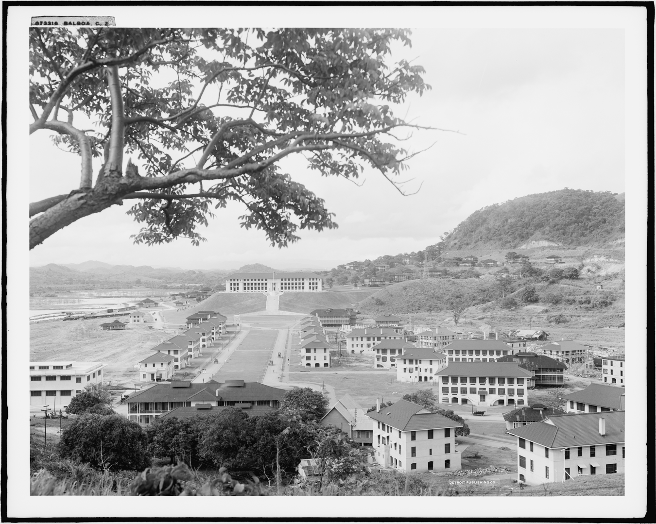
‘Balboa, CZ’, c.1920 (Library of Congress, Prints and Photographs Division, Detroit Publishing Company Collection).
Somewhat akin to Baguio’s circumstance, Balboa was to be an exclusively American enclave, if not a tropical ‘utopia’ (Missal 2008), populated by ‘white members of the [Canal’s] operating force’ – a highly-legible neo-classical architectural idiom was not needed ( Canal Record 1913c: 361). 27 Confident of the permanence of America’s occupation of the isthmus and perhaps in an effort to visually legitimize it, Lord now turned to Latin precedents. Indeed, this rationale may have also underpinned officialdom’s decision to name the town itself after a Spanish explorer and to award its parkland heart a Spanish title. When first visiting the Canal Zone in 1912, Lord diagnosed that ‘a modification of the Spanish renaissance, with appropriate adaptation of adjacent landscape’ was required ( Canal Record 1912). Panama’s intense tropical heat and stifling humidity, however, soon frustrated his efforts to formulate a modern hybrid, compelling him to change his mind (Wilson 1981). ‘Contrary to general opinion’, he later reported publicly, ‘it was impossible to adopt the type of architecture of southern climes – particularly of Mexico’ (Lord 1914: 101). Unlike its northern neighbour, Panama’s rainfall was so great that all of Balboa’s buildings required ‘colonnaded fronts and connecting colonnades, giving a continuous covered way from one end of the street to the other’ (Lord 1914: 114). 28 Now retreating into more familiar neo-classical territory, Lord decided instead to abstract Balboa’s architectural vocabulary from ‘Italian’ (if not Roman) sources ( Canal Record 1913c: 361). Apparently, ‘utility and confrontation with tropical weather and topography’ combined to motivate his new choice ( Canal Record 1913c: 361). Lord’s resultant ‘thick, light-colored, concrete-walled structures’, as Wilson (1981: 26) characterized them, ‘recalled a generalized classical origin’; nonetheless, ‘in their white stucco covering and [dark red clay] tile roofs, they evince a Latin American influence’.
With Balboa’s plan in place, the Isthmian Canal Commission was now in need of a landscape architect and, at Olmsted’s recommendation, it hired William Lyman Phillips (Jackson 1997; Reese and Reese 2013: 191–203). Harvard-educated (under Olmsted’s tutelage), Phillips was now to further develop and resolve Lord’s layout in detail. Arriving at the Canal Zone in July 1913, the landscape architect – like Olmsted Sr and Burnham before him – quickly grew enchanted with tropical vegetation, soon appreciating it as a medium to ‘indigenize’ America’s imperial enterprise. Analogous to Lord’s architectural strategy, Phillips set out to mantle, if not camouflage, the American Panamanian presence with a tropical veil. Phillips, like his architect counterpart, also saw Latin sources as rich in design potential and he made a point of exploring the Zone’s landscape, both natural and cultural. He came to esteem, for instance, the ‘charming plazas, parks, and squares built by the Spanish and French’ and hoped to mould Balboa’s landscape in their image (Jackson 1997: 35). ‘He may have been the only man on the isthmus’, his biographer asserted, ‘who understood the importance of making a visually harmonious tropical town, which would reflect the rhythm and style of life in Central America’. This was, of course, a somewhat hagiographical overstatement. Olmsted and Lord, for instance and most prominently, also knew the value of tropical harmony all too well, both aesthetically and politically.
Although not conceptualized as such, Balboa effectively became the ‘capital’ of the Canal Zone and, through its architecture and urbanism, cast the Zone’s die as American. This capital, as Wilson (1981: 26) discerned, with its ‘alignment of buildings, sequence of squares and tree-lined central axis with the raised focal point of the Administration Building, recalls many of the schemes of the City Beautiful and most especially the Mall from the McMillan Plan for Washington, DC, 1901–2, and ultimately the Court of Honor at the World’s Columbian Exposition of 1893’. ‘It personifies’, he concluded, ‘power’ – American power. Daniel Burnham would have been pleased.
Empire
Balboa, however, was not the largest town in the Canal Zone. That distinction went to a town of Spanish origin, ‘Emperador’ or ‘Emperor’, in English. Now, however, the Americans tellingly renamed it ‘Empire’. Was this new name simply a translation error or a deliberate act of misprision? In 1912, Australian writer Winifred Lewellin James (1913: 235) made a trip to Panama and visited Empire by rail (Greene 2010). There, she later told her readers, the ‘words “Welcome to Empire”, done [i.e. constructed] in letters man-size, on a slope behind the [railway station] platform, greet you hospitably’ (Figure 10). Around the same time, Ralph Percy Ashton (1914: 185–6), an English engineer then in service to the British Raj, toured the Canal Zone, studying the new American sanitation systems. Empire was on his itinerary as well. After returning to India, he publicly reported on his findings. When recounting his stop at Empire, the engineer digressed from his sanitation subject to recollect that he, like James, had been ‘struck’ by the monumental welcome sign, ‘set out in pebbles and plants in bold letters’. However, unlike the Australian, Ashton was not oblivious to the connotations, whether accidental or intentional, of the town’s English name. The sign, he explained, ‘referred to Empire town, but I think it has a deeper significance’. Offering an imperialist perspective and endorsing America’s Panamanian presence, he continued that the sign also ‘marks, one may hope, a first step on the path of the United States towards setting to rights that part of the globe’. As though now in a tirade, Ashton next fervently expounded: The United States have secured the independence of Panama by gripping her with a mailed fist. Their troops are in cantonment at Colón and Panama, and hold the central position at [the town of] Empire. Their great fortifications are in process of construction, and every thinking man who wishes for the progress of the world must thank God that it is so. In Panama since the occupation, there have been various ebullitions of self-styled patriots of the type that we know in India, some suffering from swelled head, and others from regret for the old disorder of things that has passed away, but the United States have soon put things right.

‘I[thmian] C[anal] C[ommission] Hotel at Empire, CZ’, c.1914 (Vicente Pascual collection).
In 1979, America relinquished its Canal Zone to the Republic of Panama, rendering Empire and Balboa symbolically ambivalent.
Footnotes
Acknowledgements
The author extends his thanks to and appreciation to Paulo Alcazaren, Gerard Lico, and Augusto Villalon for their assistance during his research in the Philippines. For his aid in Panama, he thanks Eduardo Tejeira Davis. Along with Davis, Carol Reese facilitated the author’s receipt of an advance copy of her (and her husband’s) study of the Canal Zone’s architecture (2013). He is also grateful to William P McLaughlin, Panama Canal historian, for securing an image of the ‘Welcome to Empire’ sign for him.