






Abstract
In many low- and middle-income countries, uneven service coverage across urban–rural gradients and tenure regimes produces highly heterogeneous household waste disposal behaviors, with important implications for public health, air quality, and environmental integrity. Using Eswatini’s 2017 National Population and Housing Census—the first national census in the country to include household waste disposal variables and the first opportunity for a georeferenced, countrywide, household-level assessment—we analyzed 2326 enumeration areas (EAs) and 6 disposal modalities: regular collection, irregular collection, public pit dumping, backyard pits, open burning, and undesignated dumping. We applied spatially explicit multivariate clustering to identify distinct disposal profiles and then evaluated geographic patterning using spatial autocorrelation and hotspot mapping. Five clusters were distinguished, revealing a pronounced urban–rural divide and strong tenure effects. Urban and company-town settings exhibited the highest reliance on regular collection (mean ≈52%) yet retained substantial open burning (≈43%), indicating persistent behavioral and/or service-quality gaps even where collection exists. Rural EAs, particularly on customary Eswatini Nation Land (both rural development areas (RDA) and non-RDA), were characterized by dominant backyard pit use (≈81%) alongside elevated public pit dumping (≈61%) and undesignated dumping (≈24%). Spatial statistics further showed concentrated rural hotspots of informal disposal practices, with notable clustering in parts of Lubombo and Shiselweni. These results support targeted, cluster-specific practical and policy interventions that combine rural service expansion, demand-side behavior change to reduce open burning, and governance arrangements that explicitly engage traditional authorities in planning, siting, and compliance.
Keywords
Introduction
Effective waste management is central to sustainable development because it directly underpins environmental protection, public health, and social equity. Yet rapid population growth, urbanization, and changing consumption have driven a steep rise in waste generation worldwide. The United Nations Environment Programme (2024) projects global waste will increase from 2.1 billion tons in 2023 to 3.8 billion tons by 2050, with low- and middle-income countries facing disproportionate impacts due to infrastructure and financing constraints. In many developing contexts, household waste disposal remains highly heterogeneous—ranging from formal municipal collection to informal and unmanaged practices such as open burning, backyard pits, and undesignated dumping—reflecting entrenched socioeconomic, cultural, and spatial disparities (Ferronato and Torretta, 2019). Such disparities intensify localized environmental degradation and health risks, reinforcing the need for context-sensitive, data-driven waste management interventions.
The environmental consequences of informal disposal are widely documented. Open burning releases toxic pollutants, including dioxins, furans, and fine particulate matter, and contributes to climate-relevant emissions such as black carbon. Wiedinmyer et al. (2014) estimate that open burning accounts for roughly 5% of global black carbon emissions, with implications for air quality and atmospheric warming. Evidence from densely populated regions indicates that these emissions can amplify regional haze events and radiative forcing (Kumar et al., 2022). Undesignated dumping, similarly prevalent, increases risks of soil and water contamination through leachate and persistent pollutants such as heavy metals and microplastics, with documented ecosystem disruption and contamination in rivers and estuaries in Latin America and Southeast Asia (Kumari and Raghubanshi, 2023; Mihai et al., 2022).
These environmental pathways translate into substantial public health burdens. Airborne emissions from burning waste are associated with respiratory and cardiovascular morbidity and heightened cancer risk. The Lancet Commission on Pollution and Health estimated that pollution contributes to approximately 9 million premature deaths annually, with the largest burden borne by low-income populations (Landrigan et al., 2018). In sub-Saharan Africa and South Asia, exposure linked to open burning is associated with elevated asthma and chronic obstructive pulmonary disease, particularly among children and older adults (Gordon et al., 2023). Uncontrolled dumping also contaminates drinking water sources and creates habitats for disease vectors, facilitating the spread of cholera, typhoid, and other waterborne diseases (Ayomoh et al., 2008; Ferronato and Torretta, 2019; Kitole et al., 2024; Raphela et al., 2024).
Waste disposal practices are shaped by interacting socioeconomic and institutional determinants. Limited household resources, constrained municipal budgets, and fragmented governance often impede the development of reliable collection, leaving households dependent on lower-cost informal alternatives (Adzawla et al., 2019; Uma et al., 2020). In rural India, for example, over half of households burn or dump waste in the absence of accessible services (Chaudhary et al., 2021). Education and awareness can modify these behaviors: higher literacy is generally associated with greater uptake of composting, recycling, and safer handling, whereas less-educated populations may continue long-standing practices despite environmental consequences (Anokye et al., 2024; Raghu and Rodrigues, 2020). At the same time, decentralized governance arrangements common in many African settings can produce uneven service delivery and inconsistent enforcement (Kumari and Raghubanshi, 2023; Osibanjo et al., 2019).
A pronounced urban–rural gradient remains a defining feature of the waste challenge. Urban areas typically have better infrastructure and more formalized collection than rural communities, yet coverage is often incomplete and strained by rapid urban expansion and informal settlement growth. In Nairobi, municipal collection reaches only about 60% of generated waste, and informal settlements rely heavily on self-managed systems (Loukil and Rouached, 2020). Rural areas across sub-Saharan Africa frequently depend on burning and dumping, and service coverage gaps can exceed 70% (Adedara et al., 2023). These disparities reflect logistical challenges, lower political prioritization of remote areas, and chronic underinvestment in rural infrastructure.
Behavioral norms and cultural expectations also sustain unsustainable practices, especially where formal alternatives are limited. In many traditional settings, burning or burying waste is perceived as practical and low-cost, and structural barriers, such as weak access to recycling infrastructure and unreliable services, can reduce the effectiveness of awareness campaigns even where health risks are recognized. Policy frameworks provide both direction and constraints. International agendas, including the Sustainable Development Goals—particularly SDG 11 on sustainable cities and SDG 12 on responsible consumption—call for inclusive waste systems, but implementation is frequently hindered by inadequate funding, weak enforcement, and limited interagency coordination (Osibanjo et al., 2019). Public–private partnerships and donor-supported initiatives can strengthen collection, as demonstrated in Ghana; however, such gains often concentrate in urban cores, leaving peri-urban and rural areas underserved (Volsuuri et al., 2022).
Eswatini, a landlocked Southern African country with a predominantly rural population (76%), exemplifies these intersecting challenges. Its coexistence of customary Eswatini Nation Land (ENL) and freehold/title-deed estates offers a useful setting for examining how land governance relates to service access. Rapid growth in cities such as Mbabane and Manzini has outpaced waste infrastructure development, producing a mixed landscape of formal and informal disposal. In rural areas, particularly those under customary tenure systems such as ENL, waste is commonly managed through open burning, backyard pits, or dumping, reflecting constrained infrastructure, entrenched practices, and governance complexity (Government of the Kingdom of Eswatini and United Nations Population Fund, 2019; Mabaso et al., 2022).
Against this backdrop, the present study maps and characterizes household waste disposal across Eswatini using the 2017 National Population and Housing Census, analyzed at the enumeration-area scale (2326 units). It applies multivariate clustering and spatial analysis to detect patterns across six disposal methods—regular collection, irregular collection, public pit dumping, backyard pits, open burning, and undesignated dumping—using the fine spatial resolution afforded by enumeration areas (EAs). By leveraging the first nationally complete, georeferenced household waste dataset in Eswatini, the study provides a baseline for identifying spatially differentiated service needs and tenure-linked disparities, with relevance for evidence-informed infrastructure planning and policy reform in Eswatini and comparable contexts.
Materials and methods
This study applies a spatially explicit multivariate clustering approach to analyze waste disposal practices in Eswatini, with the objective of identifying geographic and socioeconomic patterns related to urban–rural and land tenure disparities. The analysis is based on data from Eswatini’s 2017 National Population and Housing Census and is executed using ArcGIS Pro 3.5 (ESRI, 2025a) integrating statistical preprocessing, k-medoids clustering, and spatial visualization tools.
Data sources
The primary dataset is the 2017 National Population and Housing Census, obtained from the Central Statistical Office (CSO) of Eswatini. The census includes detailed information on household waste disposal practices across 2326 EAs—the smallest administrative units used in census collection, each averaging approximately 115 households. The dataset specifies the number of households in each EA using six waste disposal methods:
(a) Regular collection (formal municipal services),
(b) Irregular collection (sporadic or non-routine services),
(c) Public pit dumping (shared community sites),
(d) Backyard pits (on-site household burial),
(e) Open burning (combustion in open air),
(f) Undesignated dumping (unregulated discards in open areas).
These values were normalized to proportions (0–1 scale) within each EA, ensuring that the sum of all six proportions equaled 1.0. This normalization allows for comparative assessment across EAs irrespective of size and supports multivariate analysis. In addition, two contextual variables were included:
Urban/rural classification: Categorized based on national administrative boundaries as defined by the CSO and the Surveyor-General’s Office.
Land tenure type: Classified into five types—(1) Eswatini Nation Land (RDA), (2) Eswatini Nation Land (non-RDA), (3) individual tenure farms/title-deed land (ITF/TDL), (4) towns, and (5) company towns or estates. These classifications reflect the governance and land use systems influencing waste management.
Data preprocessing
To ensure data integrity, preprocessing began by validating the completeness of each EA’s household disposal data—confirming that the sum of method-specific household counts matched the total households recorded. Next, the six disposal method proportions were standardized using z-score transformation (equation (1)) to equalize variable influence and prevent bias during clustering:

where xi is the proportion of method i in an EA, μ i is the mean, and σ i the standard deviation across all EAs. Standardization is essential in multivariate clustering to prevent dominance by high-variance variables (Khan et al., 2025).
Multivariate clustering analysis
The core analysis utilized ArcGIS Pro’s Multivariate Clustering tool, which implements a k-medoids clustering algorithm tailored for multivariate spatial data (ESRI, 2025a). This algorithm partitions EAs into clusters based on similarities in their standardized waste disposal profiles. Unlike k-means, k-medoids is robust to outliers and more appropriate for non-spherical or skewed datasets, common in environmental and demographic studies (Kaufman and Rousseeuw, 2009).
The algorithm minimizes total dissimilarity within clusters by assigning each EA to a medoid—the most centrally located EA within its group—using the Manhattan distance metric, defined as:

where xik and xjk are the standardized proportions for disposal method k in EAs i and j, respectively. Manhattan distance is favored for proportion data due to its robustness to outliers and reduced sensitivity to extreme values.
The clustering follows these steps (ESRI, 2025b):
Initialization: Select k initial medoids (random or seeded).
Assignment: Assign each EA to the closest medoid.
Update: Identify the new medoid within each cluster that minimizes internal dissimilarity.
Iteration: Repeat steps 2–3 until medoids stabilize or iteration limit is reached.
To determine the optimal number of clusters (k), the Calinski–Harabasz pseudo-F statistic (Caliński and Harabasz, 1974) was used:

where SSB and SSW represent the between- and within-cluster sums of squares, k is the number of clusters, and n is the total number of EAs.
A worst-case seed strategy was used for initialization, selecting EAs with extreme values or highest proportion of undesirable waste management practices (e.g., 100% burning or dumping, 0% regular collection). This ensured that clusters captured high-risk areas critical to sustainable waste management planning.
Spatial analysis and visualization
Following clustering, spatial distribution was analyzed to explore geographic patterns across the entire Eswatini. Each EA was assigned a cluster label and visualized using ArcGIS Pro’s mapping tools. Key visualizations included:
A dominant method heatmap, identifying the disposal method with the highest proportion in each EA.
Thematic maps for each disposal method, using equal interval breaks: 0.00–0.20, 0.21–0.40, 0.41–0.60, 0.61–0.80, and 0.81–1.00.
To assess the influence of urbanization and land tenure, cluster-EA cross-tabulations were conducted. The results were visualized using:
Stacked bar charts (proportion of clusters by tenure and urbanity),
Heatmaps (intensity of disposal methods by context),
Violin plots (distributional spread of disposal method use).
Visualizations were produced using ArcGIS Pro 3.5 (Esri, Redlands, CA, USA) and R version 4.2 (R Foundation for Statistical Computing, Vienna, Austria) for statistical graphics and exploratory analysis.
Statistical validation
Clustering robustness was assessed using the silhouette coefficient, which quantifies the cohesion and separation of clusters:

where a(i) is the average dissimilarity of EA i to other EAs in the same cluster, and b(i) is the lowest average dissimilarity to any other cluster. The average silhouette coefficient across all EAs was 0.62, indicating strong and well-separated clusters (Rousseeuw, 1987).
Spatial autocorrelation was also assessed using Moran’s I statistic (Moran, 1950):

where xi and xj are cluster labels for EAs i and j,
Results
Cluster characteristics
The k-medoids clustering algorithm, applied to the standardized proportions of 6 waste disposal methods grouped the 2326 EAs into five clusters. Table 1 summarizes the mean proportions of these methods across the clusters, ordered by increasing reliance on regular collection. The clusters reveal a spectrum of waste disposal behaviors, from informal, traditional practices in rural areas to more formal systems in urban centers, with significant implications for waste management planning and policy development.
Cluster 1 (backyard pit dominance, 1042 EAs): This cluster, the largest, is characterized by a high reliance on backyard pits (mean proportion = 0.81), with minimal use of regular collection (0.02) and moderate burning (0.22). The seed EA, located in Siphofaneni (Lubombo region), exclusively used backyard pits (proportion = 1.0), reflecting traditional household-level disposal in areas with limited waste management infrastructure. This cluster represents 44.8% of EAs, indicating that nearly half of Eswatini’s EAs rely on informal, household-based methods, which can lead to numerous environmental and health issues as well as challenges in waste recovery or recycling. The prevalence of backyard pits suggests a lack of access to formal systems, highlighting the need for rural infrastructure development to transition these areas to more sustainable practices.
Cluster 2 (irregular collection dependence, 37 EAs): This cluster is defined by a high proportion of irregular collection (0.67), with low use of other methods (e.g., backyard pits = 0.05, open burning = 0.14). The seed EA, in Mpolonjeni (Hhohho region), had an irregular collection proportion of 0.957, suggesting areas with sporadic access to waste collection services, predominantly in peri-urban zones transitioning between rural and urban systems. Comprising only 1.6% of EAs, this cluster is the smallest but highlights a critical issue in waste management: the inconsistency of service delivery in transitional areas.
Cluster 3 (undesignated dumping hotspots, 65 EAs): This cluster exhibits significant undesignated dumping (0.24), alongside backyard pits (0.24) and open burning (0.20), with minimal regular collection (0.04). The seed EA had a proportion of 1.0 for undesignated dumping, indicating severe infrastructure deficits where waste is discarded in open spaces, posing environmental and health risks such as water contamination and disease vector proliferation. Representing only 2.8% of EAs, this cluster underscores the urgent need for intervention in areas with high-risk disposal practices, particularly in rural areas where formal systems are absent.
Cluster 4 (public pit dumping prevalence, 87 EAs): Dominated by public pit dumping (0.61), this cluster also shows moderate use of backyard pits (0.14) and open burning (0.18), with low regular collection (0.03). The seed EA had a public pit dumping proportion of 0.991, reflecting reliance on communal but often unmanaged disposal sites, typically in rural areas with limited formal systems. Comprising 3.7% of EAs, this cluster highlights the prevalence of communal disposal practices, which, while centralized, often lack proper management, leading to environmental hazards such as leachate contamination and the need for better waste site disposal practices.
Cluster 5 (regular collection and open burning mix, 1095 EAs): The second-largest cluster features a high proportion of regular collection (0.52) but also significant open burning (0.43), with minimal use of other methods (e.g., undesignated dumping = 0.01). The cluster as a whole reflects a mix of formal and informal practices, primarily in urban areas with municipal services. Representing 47.1% of EAs, this cluster indicates that even in areas with access to formal systems, informal practices like open burning persist, possibly due to gaps in service coverage, cultural preferences, or lack of awareness about the environmental impacts of open burning.
Mean proportions of households using waste disposal methods by cluster.
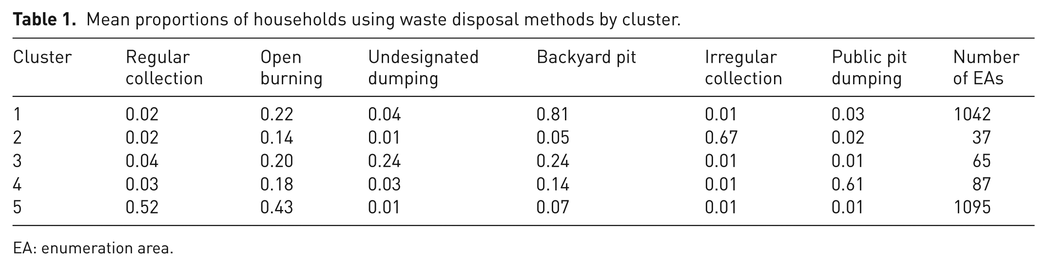
EA: enumeration area.
The clustering results were tested across values of k = 2 to k = 10, with k = 5 yielding the highest pseudo-F statistic (142.3, p < 0.001), indicating optimal separation between clusters, and the silhouette coefficient (average = 0.62), confirming good cluster cohesion and separation (Rousseeuw, 1987). These metrics ensure that the identified clusters are robust and meaningful for waste management applications, providing a reliable basis for policy targeting.
Urban/rural and land tenure distribution
The distribution of clusters across urban/rural and land tenure classifications reveals the influence of socioeconomic and governance factors on waste disposal practices, offering insights for policy targeting. Table 2 shows the percentage of EAs in each cluster across urban/rural classifications and five land tenure types: customary ENL under rural development areas (RDA), ENL non-RDA, ITF/TDL, towns, and company towns/estates.
Cluster 1 (backyard pit dominance): This cluster is overwhelmingly rural (99.2%) and associated with customary ENL RDA (60.0%) and ENL non-RDA (38.5%), reflecting traditional tenure systems in rural areas. The minimal presence in towns (0.5%), ITF/TDL (0.5%), and company towns/estates (0.5%) underscores the lack of formal waste management infrastructure in these predominantly rural, communally managed areas. The reliance on backyard pits in these regions suggests a need for decentralized waste management solutions.
Cluster 2 (irregular collection dependence): This cluster is mostly rural (83.8%) but has a notable urban presence (16.2%), with a balanced distribution across ENL RDA (40.5%), ENL non-RDA (40.5%), and towns (13.5%). The presence in towns and a small proportion in ITF/TDL (2.7%) and company towns/estates (2.7%) indicates that this cluster captures peri-urban areas where waste collection services are inconsistent. These areas represent a transitional zone where improving service reliability could facilitate the expansion of formal waste management systems, bridging the urban–rural divide.
Cluster 3 (undesignated dumping hotspots): Predominantly rural (96.9%), this cluster is associated with ENL RDA (55.4%) and ENL non-RDA (41.5%), with minimal representation in towns (1.5%) and company towns/estates (1.5%). The absence of this cluster in ITF/TDL highlights the lack of formal systems in traditional tenure areas, leading to reliance on undesignated dumping. This practice poses significant environmental risks, such as water contamination and ingestion of waste by domestic animals, necessitating urgent infrastructure development in these regions.
Cluster 4 (public pit dumping prevalence): This cluster is largely rural (94.3%), under ENL RDA (50.6%) and ENL non-RDA (43.7%), with small proportions in towns (2.3%), company towns/estates (2.3%), and ITF/TDL (1.1%). The reliance on public pits reflects communal disposal practices in rural areas with limited infrastructure, but the lack of proper waste management in these sites can lead to environmental hazards, such as leachate contamination.
Cluster 5 (regular collection and open burning mix): This cluster is predominantly urban (60.5%) and strongly associated with towns (55.0%), alongside smaller proportions in ENL RDA (15.0%), ENL non-RDA (20.0%), ITF/TDL (5.0%), and company towns/estates (5.0%). The urban dominance indicates access to municipal services, but the high open burning proportion suggests existing gaps in coverage, low collection frequency, or persistent informal practices, highlighting the need for education campaigns to reduce burning in urban areas.
Distribution of clusters by land tenure and urban/rural classification.
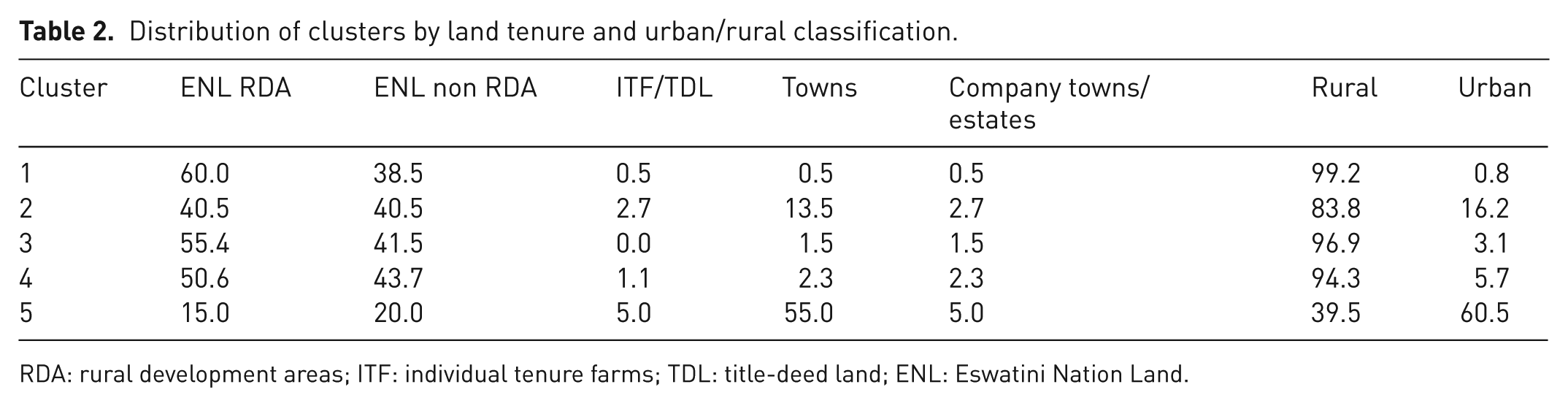
RDA: rural development areas; ITF: individual tenure farms; TDL: title-deed land; ENL: Eswatini Nation Land.
The heatmaps (Figure 1(a) and (b)) provide further insights into these patterns. Figure 1(a) shows that Towns have the highest mean regular collection proportion (0.47), while customary ENL non-RDA exhibits the highest open burning proportion (0.52). Company towns/estates have a high backyard pit proportion (0.66), reflecting unique waste management practices in these areas. Figure 1(b) indicates that urban EAs have a mean regular collection proportion of 0.50, while rural EAs show a open burning proportion of 0.49, underscoring the urban–rural divide in waste management infrastructure.
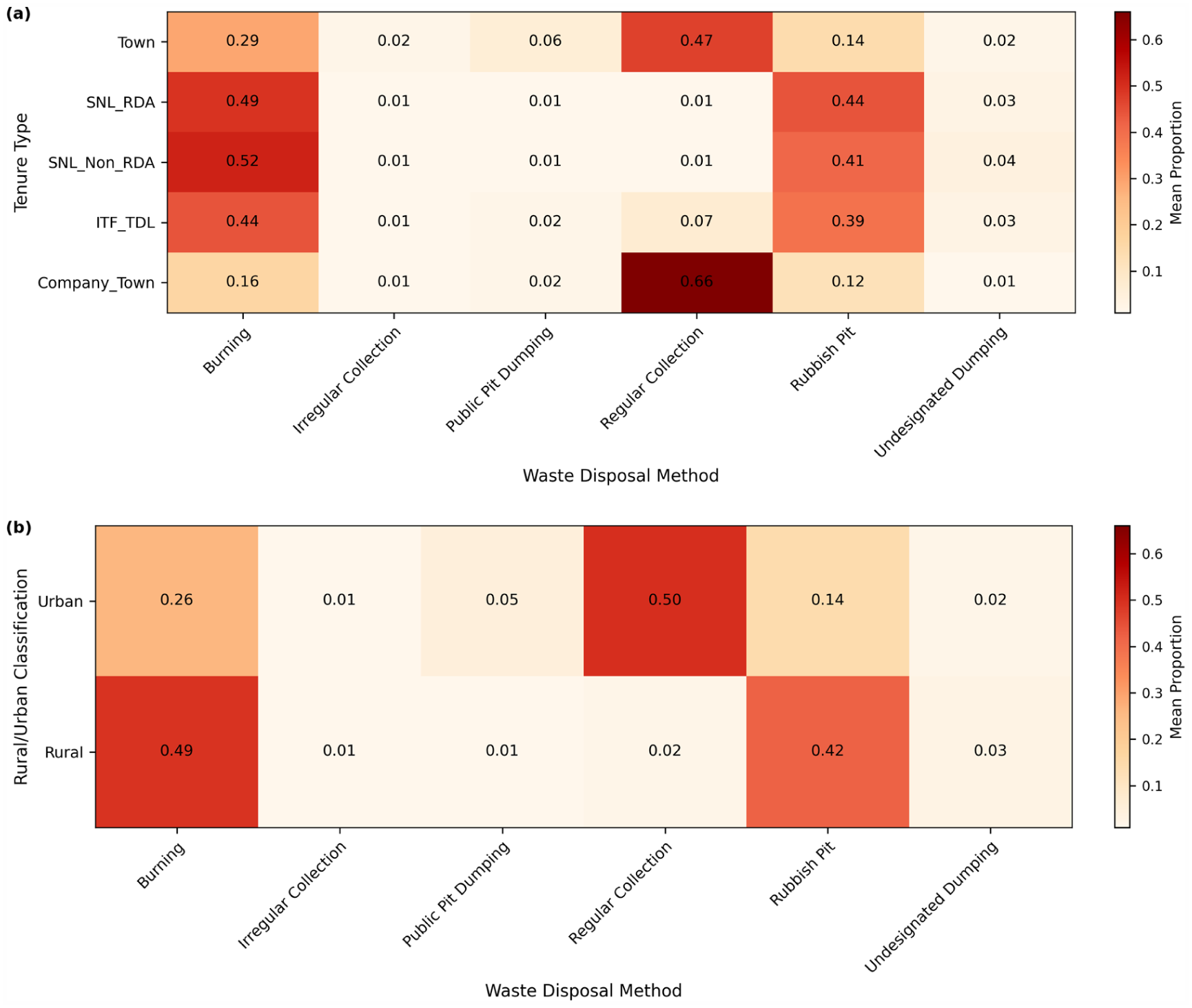
Mean proportions of household waste disposal methods across (a) land tenure categories and (b) rural–urban classification in Eswatini, based on the 2017 Population and Housing Census (enumeration-area level).
Spatial patterns of waste disposal
The spatial distribution of clusters and individual waste disposal methods provides critical insights for geographic targeting of waste management interventions. Figure 2 shows the geographic distribution of the five clusters across Eswatini, highlighting regional variations in waste disposal practices. Cluster 5 (regular collection) is concentrated in urban centers such as Mbabane (Hhohho), Ezulwini (Hhohho), Manzini (Manzini), and Nhlangano (Shiselweni), reflecting the availability of municipal services in these areas. Cluster 1 (backyard pits) dominates rural areas, particularly in Lubombo (e.g., Siphofaneni, Siteki) and Shiselweni (e.g., Hluti, Hlushwana), indicating widespread traditional waste disposal practices in regions with limited infrastructure. Cluster 2 (irregular collection) is evident in peri-urban areas near the major cities Mbabane (e.g., Mpolonjeni) and Manzini, where sporadic services may be common. Clusters 3 (undesignated dumping) and 4 (public pit dumping) are scattered across highly populated rural areas, with notable concentrations in Hhohho (e.g., Buhleni), Lubombo (e.g., Lomahasha), and Shiselweni (e.g., Hluti). Moran’s I statistic for the cluster labels was 0.48 (p < 0.001), confirming significant spatial autocorrelation and validating the geographic clustering of waste disposal practices.
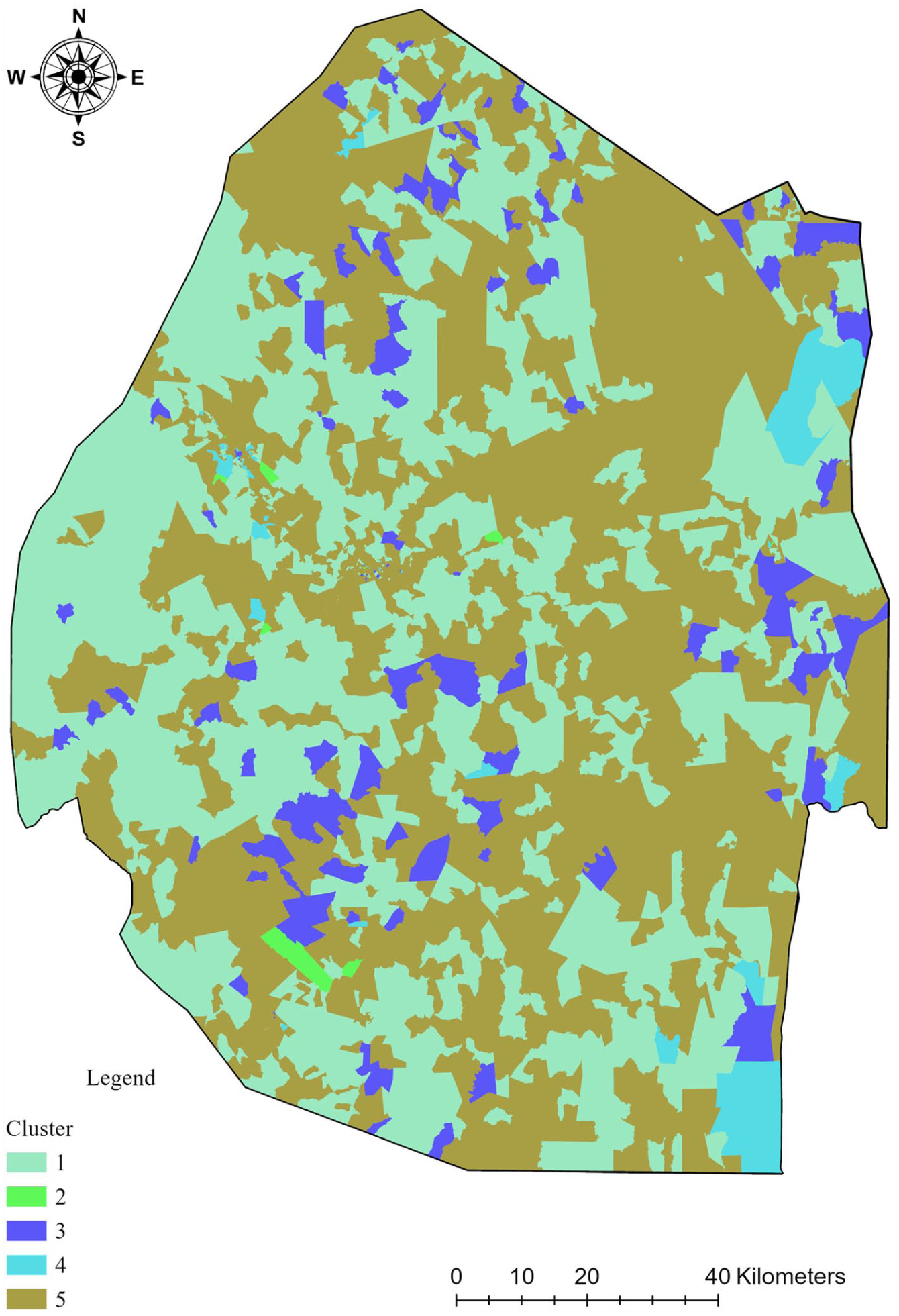
Spatial distribution of waste disposal clusters across Eswatini.
Open burning
As shown in Figure 3, the proportion of households using burning is highest (0.81–1.00) in rural areas across all regions, particularly in Hhohho (e.g., Pigg’s Peak), Manzini (e.g., Mafutseni), Lubombo (e.g., Mhlume, Siphofaneni), and Shiselweni (e.g., Nhlangano, Hluti). Urban centers like Mbabane and Manzini show lower proportions (= <0.20), reflecting access to formal systems. However, the high burning proportion in cluster 5 (0.43) indicates that even urban areas with regular collection engage in this practice, possibly due to gaps in service coverage, collection frequency, or cultural preferences. This widespread open burning poses significant air quality risks.
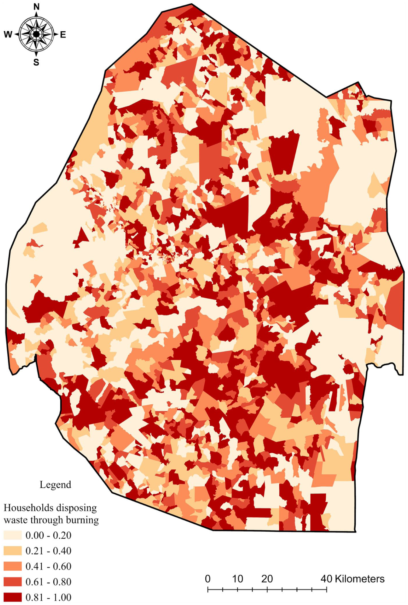
Spatial distribution of open burning proportions across Eswatini.
Irregular collection
As shown in Figure 4, irregular collection is most prevalent (0.61–0.80) in peri-urban households near Mbabane (e.g., Mpolonjeni, Langabhi) and Manzini (e.g., Matsapha), aligning with cluster 2’s dominance (mean proportion = 0.67). Rural areas in Lubombo (e.g., Siphofaneni, Big Bend) and Shiselweni (e.g., Hluti, Lavumisa) show minimal irregular collection (= <0.20), reflecting the absence of even sporadic waste collection services in these areas. The concentration in peri-urban areas suggests an opportunity to improve service consistency, which could facilitate the expansion of formal systems to nearby rural areas.
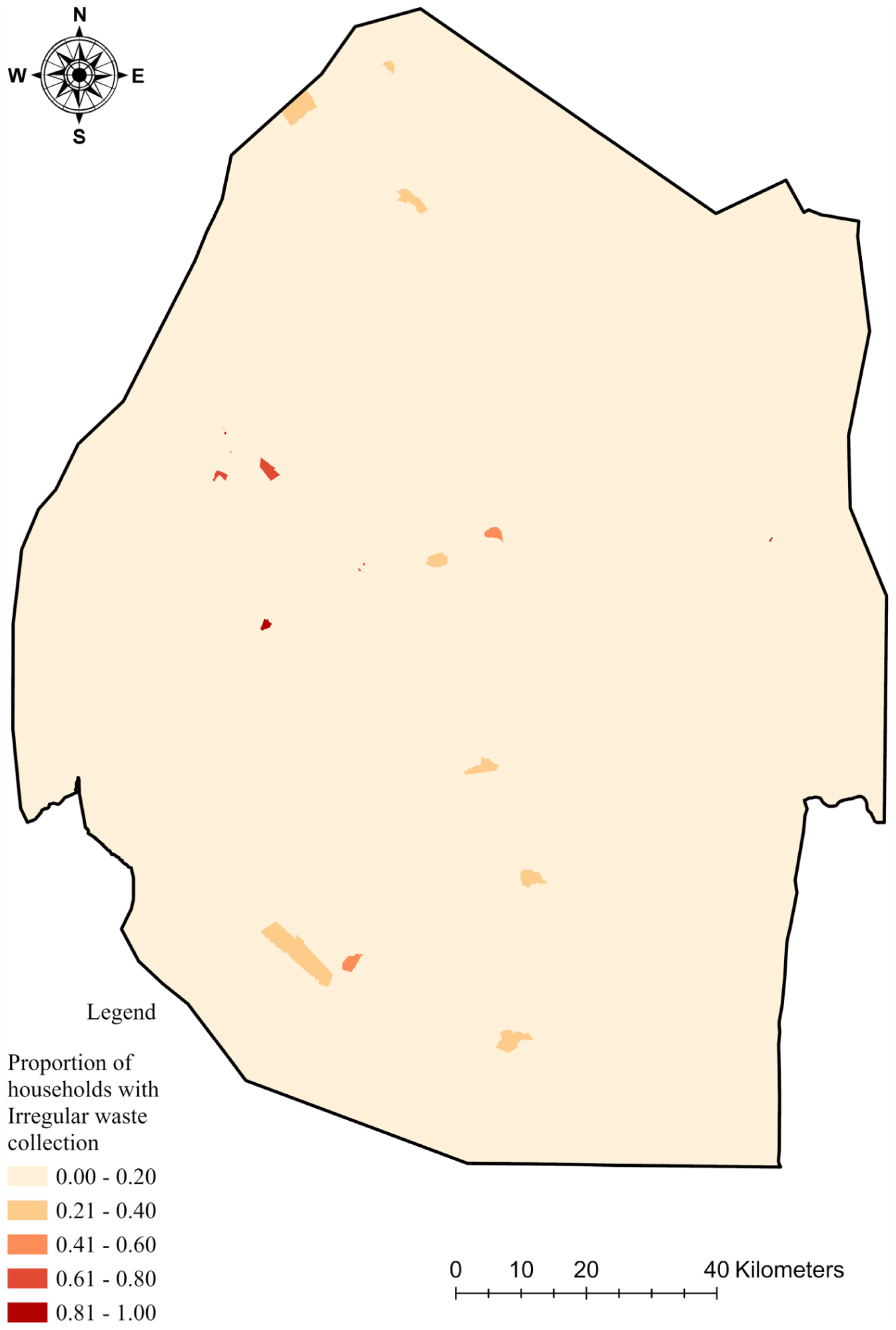
Spatial distribution of irregular collection proportions across Eswatini.
Public pit dumping
Figure 5 shows that public pit dumping is concentrated (0.61–0.80) in rural areas in Hhohho (e.g., Mhlume, Tshaneni), Lubombo (e.g., Siteki, Lomahasha), and Shiselweni (e.g., Hluti, Sithobela), corresponding to cluster 4’s prevalence (mean proportion = 0.61). Urban areas such as Mbabane and Manzini exhibit low proportions (= <0.20) of households using public pits, indicating reliance on formal systems (Figure 5). The prevalence of public pit dumping in rural areas underscores the use of communal but often unmanaged disposal sites, which can lead to environmental hazards like leachate contamination.
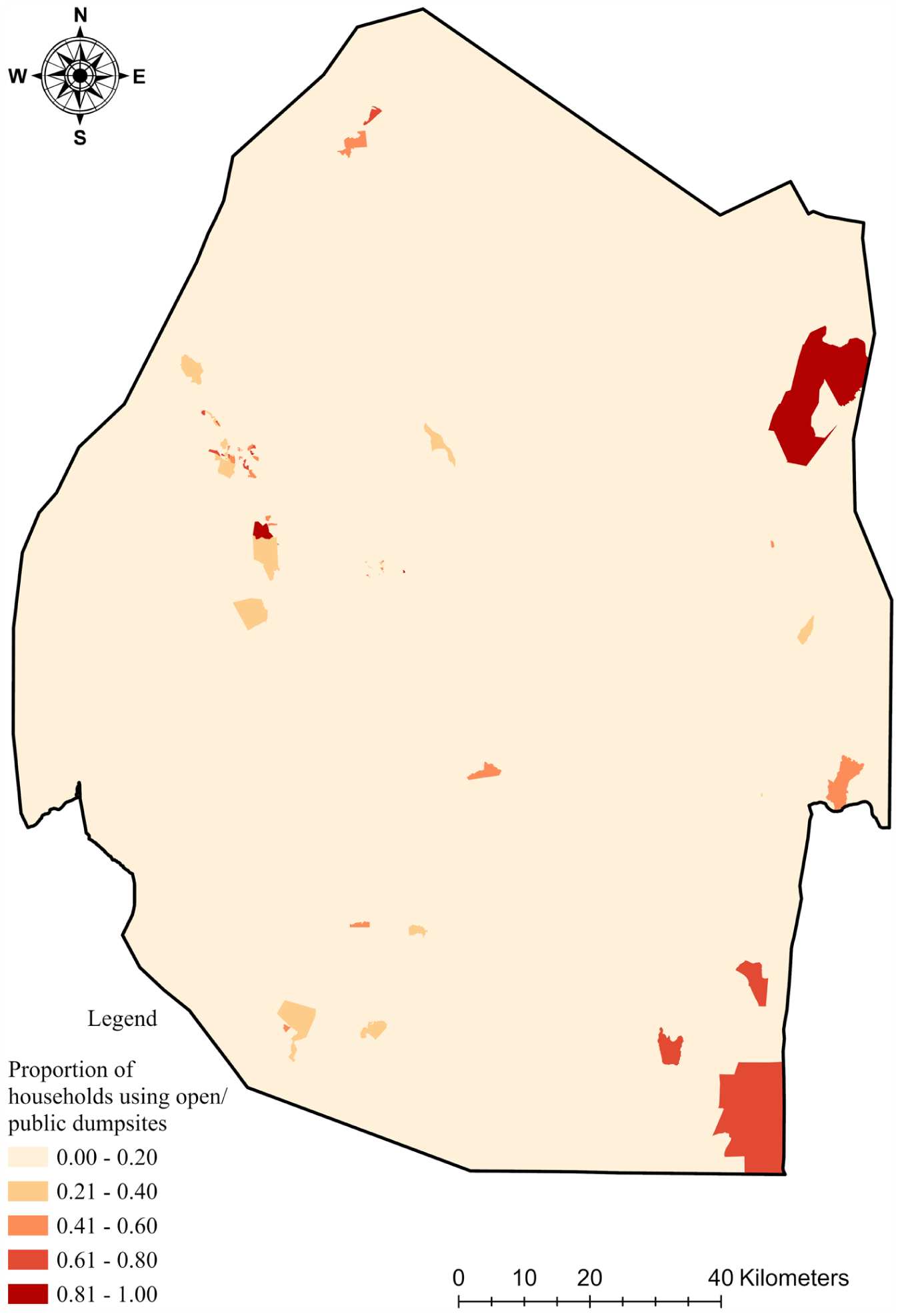
Spatial distribution of public pit dumping proportions across Eswatini.
Regular collection
Regular collection is highest (0.81–1.00) in urban centers like Mbabane, Manzini, and Nhlangano, as well as smaller towns like Matsapha and Ezulwini, corresponding to cluster 5’s dominance (mean proportion = 0.52) (Figure 6). High population density areas that are classified as rural but have emerging urban characteristics such as those in Lubombo (e.g., Siphofaneni, Big Bend) and Shiselweni (e.g., Hluti) show low proportions, highlighting the urban–rural disparity in formal waste management infrastructure. This disparity underscores the need for infrastructure expansion to rural areas to reduce reliance on informal methods. Some gazetted urban areas and other company towns such as Lavumisa and Big Bend also possess these characteristics.
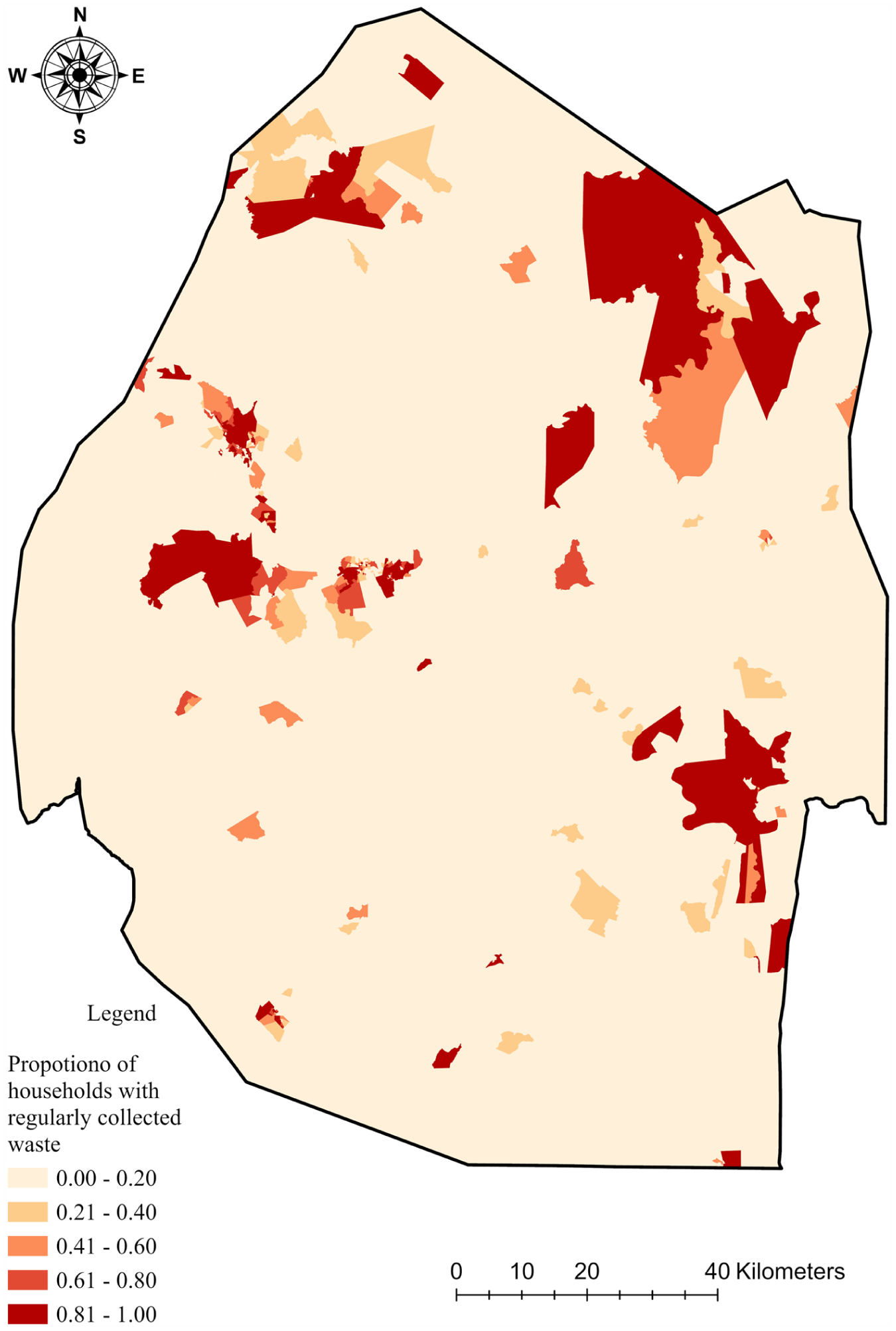
Spatial distribution of regular collection proportions across Eswatini.
Undesignated dumping
Figure 7 shows that undesignated dumping is most prevalent (0.61–0.80) in rural areas, particularly in Hhohho (e.g., Nkhaba), Lubombo (e.g., Mhlume, Siteki, Lomahasha), and Shiselweni (e.g., Hluti, Sithobela), aligning with cluster 3’s characteristics (mean proportion = 0.24). The major urban centers like Mbabane and Manzini show minimal undesignated dumping, reflecting better waste management systems. The prevalence of undesignated dumping in rural areas further highlights the lack of infrastructure and enforcement, posing significant environmental and health risks.
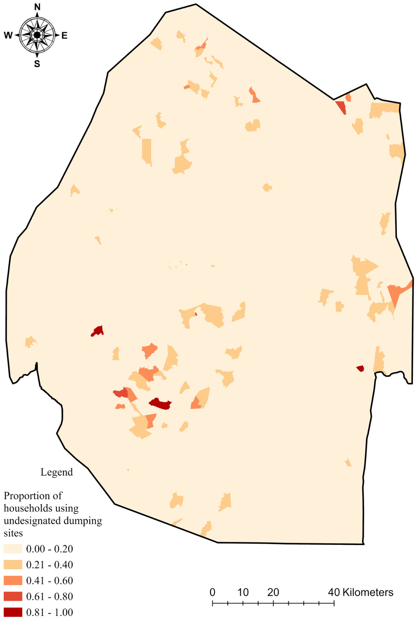
Spatial distribution of undesignated dumping proportions across Eswatini.
Discussion
The multivariate clustering and spatial analysis of Eswatini’s 2017 National Population and Housing Census data identified five distinct clusters of waste disposal behavior. These clusters reveal clear geographic, socioeconomic, and land governance disparities, which reflect broader systemic patterns observed across sub-Saharan Africa and the global south. The findings offer crucial insights for designing equitable and sustainable waste management interventions.
Urban–rural disparities in waste management practices
The urban–rural divide in waste disposal practices observed in Eswatini aligns with trends reported across sub-Saharan Africa, where urban areas typically benefit from formal waste collection services, while rural areas rely on informal or traditional methods (Azunre et al., 2022; Muheirwe et al., 2022). Cluster 5, characterized by a high reliance on regular waste collection and a predominantly urban environment, reflects the concentration of municipal services in major urban centers such as Mbabane and Manzini.
However, the persistence of open burning in urban clusters (43% in cluster 5) signals critical gaps in service coverage and behavioral adoption, especially in informal settlements. This mirrors findings from Accra, Ghana, where 35% of households resort to burning despite the presence of formal services due to inconsistency and lack of accessibility (Grangxabe et al., 2024).
In rural clusters (clusters 1, 3, and 4), informal methods dominate—e.g., backyard pits (81% in cluster 1), undesignated dumping (24% in cluster 3), and public pit dumping (61% in cluster 4). These patterns reflect the absence of infrastructure in rural areas, a reality documented in Ethiopia, where over half of households lack access to any structured waste collection (Wright et al., 2024). In Eswatini, such practices are especially prevalent in Lubombo and Shiselweni, where geographic isolation and poverty exacerbate infrastructure gaps. Cluster 2 represents peri-urban transition zones, with 67% relying on irregular collection—echoing experiences in peri-urban South Africa where fragmented service delivery is the norm (Breukelman et al., 2022).
Land tenure and waste disposal
Land tenure emerged as a critical structural determinant of disposal methods. Clusters with high rates of informal disposal (1, 3, 4) were predominantly associated with customary ENL, under both RDA and non-RDA categories. These customary systems, governed by local chiefs, often lack formal waste infrastructure due to weak institutional integration and minimal investment (Mushala et al., 1998; Sihlongonyane and Simelane, 2017). Similar tenure-linked disparities have been observed in Zimbabwe and Zambia, where communal land management correlates with over 70% reliance on unregulated disposal (Muheirwe et al., 2024).
In contrast, cluster 5 is concentrated in formal towns and titled lands, highlighting the role of statutory governance in supporting formal waste services. The underrepresentation of cluster 5 in ENL areas underscores the governance gap and the difficulty of expanding formal services without engaging traditional institutions. This aligns with the Botswana experience, where inclusion of tribal authorities into local governance structures significantly improved rural sanitation outcomes (Nyika and Dinka, 2023).
Environmental and public health implications
The dominance of open burning across all clusters (ranging from 14% to 43%) raises urgent environmental and health concerns. Open burning releases hazardous pollutants including dioxins, furans, and black carbon—contributing to regional air pollution and climate forcing. Wiedinmyer et al. (2014) estimate that such practices account for nearly 5% of global black carbon emissions, with sub-Saharan Africa being a major contributor. In Eswatini, where over 50% of the population lives below the poverty line (World Bank, 2025) exposure to burning emissions exacerbates existing health inequities. Recent studies link these emissions to a 40% higher risk of asthma and respiratory infections, particularly among children and the elderly (Lankoandé et al., 2024).
Undesignated dumping (especially in cluster 3) and unmanaged public pits (cluster 4) further threaten water quality and ecosystem health. These methods expose communities to leachate containing heavy metals and microplastics, as confirmed in aquatic systems across Kenya and Nigeria (Ali and Gujiba, 2024; Blettler et al., 2018).
Policy implications
The spatially explicit cluster typology provides a practical targeting framework for Eswatini: it identifies where specific combinations of disposal practices co-occur and where service gaps are most likely, enabling municipalities and national agencies to prioritize investments and enforcement geographically rather than applying uniform interventions. Because the evidence is cross-sectional, the recommendations below are framed as place-based priorities aligned with observed spatial configurations, not as causal claims.
Cluster-targeted priorities
Remote rural areas dominated by backyard pits and associated informal practices should be prioritized for decentralized service models (e.g., scheduled mobile/communal collection points, low-cost containment and safe handling guidance for pits) supported by basic equipment and training for local operators.
Peri-urban and transitional settlements characterized by irregular collection require service extension and reliability improvements (route optimization, predictable schedules, and last-mile access), coupled with spatial planning controls to avoid further growth without commensurate waste services.
Semi-rural zones with elevated undesignated dumping would benefit from regulated drop-off/transfer points, routine monitoring of known dumping corridors, and targeted behavior change communication that focuses on convenience, enforcement visibility, and local norms.
Collectivist rural contexts using unmanaged public pits should be supported through formal designation and minimum engineering/operational standards for communal sites (fencing, access control, periodic cover/clean-out where feasible), with locally appointed stewards and integration into broader WASH/community health programs.
Urban areas with high formal collection yet persistent open burning call for service-quality audits (missed areas, affordability barriers, and container access), strengthened by accessible diversion options (sorting/collection for recyclables where viable) and enforceable restrictions on open burning.
The tenure gradient indicates that interventions must be institutionally differentiated: in predominantly rural and customary ENL settings, co-production with traditional authorities and community structures is likely essential for siting communal facilities, enforcing by-laws, and sustaining local stewardship; in towns and estates, municipal performance management and contractor accountability are more decisive. Across all contexts, a small set of cluster-specific indicators (coverage, collection reliability, observed dumping/burning incidence, functionality of communal sites) can support monitoring and adaptive management. While waste practices can vary seasonally and households may mix methods, the cluster outputs offer a baseline for targeting and benchmarking. Although this analysis is based on the 2017 census, subsequent Eswatini-focused waste-characterization evidence suggests continued reliance on informal disposal pathways in the absence of major service transformations, supporting the value of the census as a national baseline (Mabaso et al., 2022; Nxumalo et al., 2020). Future iterations of census or comparable surveys, alongside localized waste composition and qualitative studies, can test change over time and better explain the social dynamics underpinning method choice.
Conclusions
This study delivers the first georeferenced, countrywide, household-level assessment of waste disposal practices in Eswatini using the 2017 National Population and Housing Census—the first census in the country to include waste disposal variables and the only dataset with complete national household coverage for this purpose. By applying spatial multivariate clustering to 2326 EAs, we derived five empirically distinct waste disposal profiles that expose pronounced inequalities in access to formal services and the persistence of informal practices along urban–rural and land tenure gradients.
Across the country, formal collection is concentrated in urban centers and in towns/estate contexts, whereas rural and communally governed areas—particularly on ENL (RDA and non-RDA)—remain dominated by backyard pits, public pit dumping, open burning, and undesignated dumping. These spatially coherent patterns indicate persistent infrastructure and institutional gaps and imply heightened risks of air pollution, soil and water contamination, and conditions conducive to vector breeding. At the same time, we acknowledge that household waste disposal is shaped by social dynamics—convenience, cultural norms, and seasonality—and households may combine methods within the same locality. While our results provide a robust national baseline, future mixed-method work and updated longitudinal datasets are needed to validate micro-level spatio-temporal dynamics and to assess change over time.
Policy relevance lies in translating heterogeneous behaviors into actionable, place-based typologies. The cluster map provides a practical targeting tool for prioritizing investments, auditing service reliability in ostensibly serviced urban areas, and designing tenure-sensitive governance arrangements. In customary SNL settings, effective implementation is likely to depend on co-production with traditional authorities for siting, compliance, and local stewardship, while peri-urban transition zones require reliable service expansion to prevent persistent informal disposal. Overall, the framework offers a replicable approach for other low- and middle-income countries seeking equitable, data-informed pathways toward safer and more sustainable waste governance.
Footnotes
Acknowledgements
We are grateful to the Central Statistical Office (Government of the Kingdom of Eswatini) for availing the data used in this work.

Funding
The author received no financial support for the research, authorship, and/or publication of this article.
Declaration of conflicting interests
The author declared no potential conflicts of interest with respect to the research, authorship, and/or publication of this article.
Data availability statement
The primary data analyzed in this study (Eswatini’s 2017 National Population and Housing Census data) were obtained from the Government of Eswatini’s Central Statistical Office (CSO) and are available upon reasonable request and subject to approval from the CSO.