
Abstract
The neighborhood has been the dominant spatial unit in urban planning since the early 20th century. Criticisms of the neighborhood unit include disagreements about defining boundaries, methodological challenges in capturing neighborhood effects, and negative impacts on communities. With advancements in data management, and public data available at smaller units (street block or property), quantitative analyses are possible at the micro-scale. This commentary draws on crime research and prevention to illustrate the benefits of micro-scale approaches to quantitative analyses in the field of urban planning, arguing that the devolution to smaller scales may be a vehicle for efficient resource allocation.
Introduction
Conceptualizing neighborhoods as organized units in urban society has been a dominant perspective in the social sciences. Neighborhoods, also referred to as the meso spatial scale, were originally defined as areas with 5,000 to 9,000 residents within approximately 160 acres containing local public and private services that contribute to a shared social life (Perry 1929). The introduction of the term neighborhood unit (Johnson 2002), the discourse on the organization of city life (e.g., R. E. Park 1915; R. E. Park, Burgess, and McKenzie 1925), and the rise of the neighborhood unit theory (Perry 1929) positioned the neighborhood as the standardized unit of analysis used in quantitative urban planning research (Chaskin 1997, 1998; Coulton et al. 2001; Isaacs 1948; Jenks and Dempsey 2007; Kallus and Law-Yone 1997; Lawhon 2009; Mehaffy, Porta, and Romice 2015; Minnery et al. 2009). Accordingly, the neighborhood concept has influenced how cities have managed urban growth for many decades. With neighborhoods as units of analysis and action, policymakers and practitioners often focus on neighborhood-based interventions (Chaskin 1997). A primary justification for neighborhood-based interventions is the theory of neighborhood effects, which identifies the neighborhood as a discrete scale with meaningful impacts on life outcomes (Ellen and Turner 1997; Mayer and Jencks 1989; Sampson 2012; Sampson, Morenoff, and Gannon-Rowley 2002; van Ham et al. 2012).
Given the policy relevance attributed to neighborhoods, a primary challenge for urban planning research and practice is the definition of neighborhood boundaries. Neighborhoods are socially constructed, and their use, activity, identity, and expression of community have no set boundaries, take on various roles, adapt to trends and practices, and change over time (Chaskin 1997; Kallus and Law-Yone 1997; Martin 2003; Talen 2000). Local actors often disagree on how to properly define boundaries (Galster 2001). Therefore, “the delineation of boundaries is a negotiated process; it is a product of individual cognition, collective perceptions, and organized attempts to codify boundaries to serve political or instrumental aims” (Chaskin 1997, 539). These socially defined neighborhood boundaries may also be identified via participatory strategies and cognitive mapping, often identifying an array of overlapping conceptualizations (Campbell et al. 2009; Coulton et al. 2001; Hwang 2016).
Nonetheless, neighborhood analyses are most often operationalized by Census-defined boundaries, and census tracts specifically, in the context of quantitative planning research. Consistent with Perry’s (1929) neighborhood unit theory, census tracts generally contain 1,200 to 8,000 residents, but their spatial extent varies widely depending on the density of the area (U.S. Census Bureau 2022). Although census tracts are frequently used to represent neighborhoods in quantitative research due to data availability from the U.S. Census (Allen 2018; Coulton et al. 2001; Talen 2017), the broad application of this scale has been criticized in the literature for its conceptual inflexibility (e.g., Coulton et al. 2001; Jenks and Dempsey 2007; Lee et al. 2008; Logan 2018).
Criticisms regarding administrative boundaries and use of neighborhood scale range from representational to methodological issues. Census tracts and other commonly used neighborhood boundaries may not accurately represent social life, thus introducing bias or underestimating neighborhood effects (Coulton et al. 2001; Jenks and Dempsey 2007). Neighborhood attributes (e.g., structural, sociodemographic, political, and environmental) can vary considerably and each of these attributes may not be available at the same spatial scale (Galster 2001). Yet spatial aggregation treats these attributes as homogeneous and masks within-neighborhood heterogeneity across a range of important features. This leaves neighborhood research subject to the modifiable areal unit problem, in which results are sensitive to the spatial scale and spatial arrangement used in the analyses (Openshaw and Taylor 1979). Furthermore, not all neighborhood characteristics are available at the same spatial scale, nor can they be delineated within the same boundaries (Galster 2001). Spatial aggregation with attributes operating at different scales may result in unevenly distributed data and spatial bias that over- or underrepresents an attribute in a neighborhood.
These criticisms extend to the impact of the neighborhood unit approach on urban morphology, the functioning of cities, and the formation of social structures within urban areas. Some scholars argue neighborhood-oriented planning promotes homogeneity, advances social sorting, and contributes to the perpetuation of residential segregation (Isaacs 1948; Lawhon 2009). Indeed, Perry advocated for homogeneous neighborhoods within the neighborhood unit theory to create a sense of community and feeling of belonging (Lawhon 2009). Consequently, this notion of the homogeneous neighborhood was used to enforce racially restrictive covenants and deed restrictions as instruments for segregation (Gotham 2008; Isaacs 1948). In addition to the lack of social interaction and inclusion, there are numerous examples of how the neighborhood unit undermines the efficient use of resources and functional movement within urban areas, including public transportation and walkability (Mehaffy, Porta, and Romice 2015). Alexander (1965) contends that planning focused squarely on the neighborhood misapprehends the complex and interrelated nature of the urban fabric:
When we describe the city in terms of neighborhoods, we implicitly assume that the smaller elements within any one of these neighborhoods belong together so tightly that they only interact with elements in other neighborhoods through the medium of the neighborhood to which they themselves belong.
Urban planning scholars have long acknowledged the potential of the micro-scale—spatial units smaller than neighborhoods such as properties, blocks, or street segments, for example, used as the unit of analysis—for studying urban dynamics and planning application to unmask variation within neighborhoods. For example, Suttles (1972) proposed that neighborhoods are first defined at the micro-level with the face-block (i.e., two sides of one street between intersecting streets, or what is often referred to as a “street segment”). Consistent with this approach, Webster (2003) explored the concept of micro-neighborhood attributes (i.e., the aggregation of a small number of adjacent properties), and Kearns and Parkinson (2001) captured function at different scales across time and space using a multilayered approach. Recognizing the importance of scale when designing place-based interventions, Ellickson (1999, 76) warned that “the way to multiply big problems is to neglect small ones.”
The micro-scale also plays an important role in theories of urban space. Jane Jacobs’s (1961) classic critique of modernist planning highlights the spatial form of the city block as a crucial catalyst of urban community, with short blocks and a highly concentrated diversity of uses leading to greater street activity and vitality. The city block is also the scale at which urban residents frequently experience urban space, and consequently the scale at which the “neighborhood” is most often experienced. As Tuan (1975, 158) notes, “To many people of Boston’s working-class West End neighborhood . . . neighborhood is not the West End but a small part of it, a segment or a street corner in which they live and carry on their neighboring activities.” Micro-scale conceptualizations may thus offer more comprehensive understandings of the experience of urban space than geographies devised at larger spatial scales.
Nonetheless, the micro-scale approach—that is, the use of units of analysis such as properties, street segments, or blocks—is underused in quantitative urban planning research and practice. Despite the representation challenges and methodological issues associated with aggregated data at the meso-scale, as well as the documented negative impacts of the neighborhood unit concept, neighborhoods continue to dominate quantitative urban research, planning practice, and the distribution of local resources. We argue there is much to be gained from urban planning micro-scale analyses and application. Moreover, advancements in technology and data management, as well as the availability of public administrative data sets (e.g., property assessor, building permits, land use and zoning, code violations), have removed the need to rely on larger spatial aggregations and allow more targeted interventions.
The field of criminology, with its increasing focus on quantitative research at small spatial scales to understand and respond to crime, offers an instructive example. Similar to urban planning, the study of crime and place is interdisciplinary, with a historical tradition of relying on meso-level neighborhood units to understand spatial patterns (for review, see Wilcox, Tillyer, and Ousey 2023). Yet research and practice over the past three decades have demonstrated the importance of micro-scale analysis and intervention. Criminology serves as more than an analog here: a growing body of empirical evidence documenting the relationship between crime and the built environment and other urban planning factors (e.g., environmental design, private investment, community and economic development initiatives, vacant lots, business activity) underscores potential benefits in the devolution to a smaller scale in quantitative research.
The Devolution of Crime and Place Research to Smaller Scales
Similar to other fields, criminology has relied on the concept of neighborhood to study “place” and its connection to social and urban life. Historically, criminologists explored the effects of neighborhood-level social disorganization (Shaw and McKay 1942) and more recently, collective efficacy (i.e., norms used in a community to achieve public order) (Sampson, Raudenbush, and Earls 1997), on crime in cities. Yet this neighborhood focus was unable to account for what has become a consistent empirical finding in crime and place studies: there is considerable within-neighborhood variability in crime (Groff, Weisburd, and Yang 2010), with a small proportion of micro-places (e.g., street blocks or street segments) accounting for a disproportionate amount of a city’s crime (Sherman, Gartin, and Buerger 1989), or what Weisburd (2015, 2018) has termed the law of crime concentration at places. A recent study examining spatiotemporal crime patterns in six large U.S. cities revealed that between 3.4 and 10.4 percent of street segments within a city generate 50 percent of all crime over an 11-year period (Walter, Tillyer, and Acolin 2022). One implication of this concentration is that changes in crime at a small number of locations can have an outsized impact on a city’s overall crime levels (Braga, Hureau, and Papachristos 2011; Braga, Papachristos, and Hureau 2010; Weisburd et al. 2004). As Weisburd (2018, 7) argues, “This empirical reality suggests that crime prevention resources should be concentrated at hot spots of crime rather than at larger geographies such as [police] beats or neighborhoods for the maximum crime prevention outcomes.”
Consistent with this empirical reality of crime concentration, research and practice have shifted in a way that is relevant to the proposed devolution of urban planning research and practice to smaller spatial scales. First, and in line with criticisms outlined above, criminological scholarship challenges the treatment of neighborhoods as static, homogeneous units, noting the variability in social life and built environment characteristics within such aggregates and acknowledging the limitations of analyzing correlates of crime using tract-level measures (Barton, Valasik, and Brault 2021; Hipp 2007; Tita and Radil 2010; Vogel 2016). As an example, Figure 1 highlights crime incident 1 variation within high and low crime census tracts in the City of Chicago. The variation that is lost by embracing the meso-level only approach is apparent in both census tracts. The census tract with low crime has several segments 2 with a high number of crime incidents, whereas the census tract with high crime contains several segments with only one or no crime incidents.
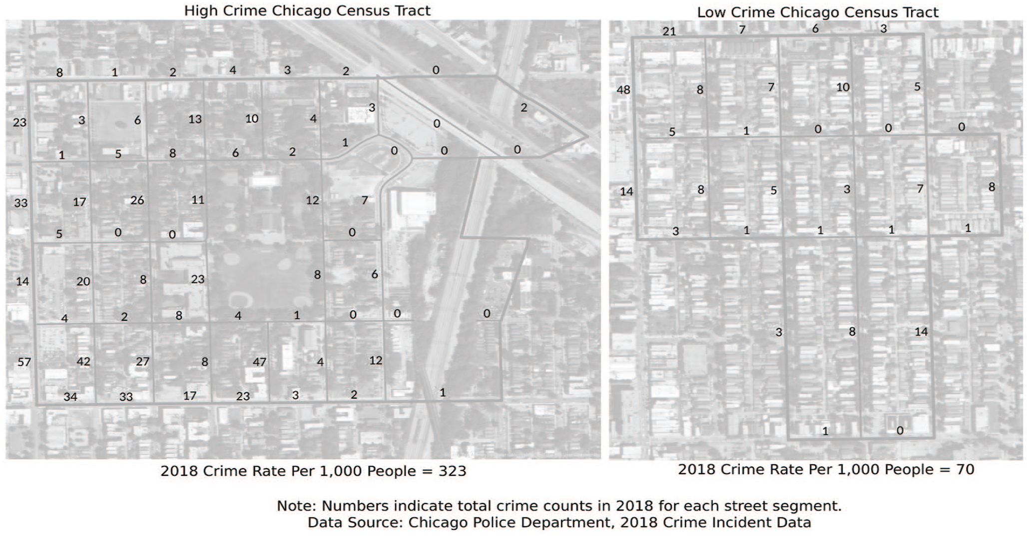
Street-to-street crime incident variation in census tracts.
In this vein, some researchers have conceptualized neighborhoods not as self-contained distinct geographic units, but as areas that may produce spillover effects to surrounding areas (Cohen and Tita 1999; Guerette and Bowers 2009; Morenoff, Sampson, and Raudenbush 2001; Wilcox, Tillyer, and Ousey 2023). Others have promoted the use of “egohoods,” in which each focal point is made the center of a neighborhood, with a buffer that captures near neighbors (Hipp and Boessen 2013). Most relevant for our purposes, others have measured indicators of social life and the built environment at smaller spatial scales, arguing that the processes that produce crime patterns are more applicable at smaller units of analysis, such a street segments, where residents enjoy a greater degree of familiarity with one another (e.g., Groff 2015; Weisburd, Groff, and Yang 2012). Similarly, multilevel investigations of spatial crime patterns explore how micro- and meso-level features work in conjunction to produce spatial crime patterns (Tillyer, Wilcox, and Walter 2021; Wilcox and Tillyer 2018). In sum, the field has shifted away from viewing crime—and the features and processes that produce its patterning—as homogeneous within neighborhoods (Weisburd, Groff, and Yang 2012; Wilcox, Tillyer, and Ousey 2023).
Second, and consistent with Weisburd’s (2018) assertion above, micro-level crime concentrations highlight how research and the spatial scale at which it is conducted can inform practice. Given within-neighborhood heterogeneity, targeted responses to crime that focus on small units tend to be both more effective and efficient. An established body of empirical studies shows that hot spots policing, in which law enforcement efforts are targeted at small geographic units with high levels of crime concentration, significantly reduces crime (Braga and Weisburd 2022). Moreover, recent evidence suggests hot spots policing strategies may also improve collective efficacy at crime hot spots by increasing informal social control to promote societal norms and rules among residents (Kochel and Weisburd 2019).
Third, research on the spatial distribution of crime within cities offers more than an example; it has direct public safety implications for urban planning, development, and city management. There is a growing body of research that shows placed-based improvements and environmental design are effective in reducing fear of crime and improving public safety (Cozens, Saville and Hillier 2005). Recent research shows that investment activity and code enforcement are significantly and negatively related to crime on street segments over time (Tillyer, Acolin, and Walter 2022), suggesting that cities can direct, incentivize, or even compel various activities to maximize public safety benefits, with such interventions best suited for small spatial scales. Moreover, investment activity and code enforcement also produced modest reductions in crime over time on adjacent street segments (Tillyer, Acolin, and Walter 2022), demonstrating that targeted intervention can produce a diffusion of crime prevention benefits rather than displacing crime to nearby locations (see also Guerette and Bowers 2009; Weisburd et al. 2006). Additional research has demonstrated public safety benefits associated with housing repair programs (South, MacDonald, and Reina 2021), housing demolition (Wheeler, Kim, and Phillips 2018), and restoration of blighted abandoned buildings and vacant land (Branas et al. 2016; Branas et al. 2018; Kondo et al. 2015).
Finally, while public safety represents just one priority of municipalities, recent research reveals within-neighborhood variability among other relevant social and health outcomes that may call for more nuanced approaches to understanding and addressing the diverse and varied needs of communities. For example, works by Weisburd et al. (2018) and Weisburd and White (2019) demonstrate that residents at crime hot spots also experienced significantly greater adverse mental and physical health outcomes. In the section that follows, we explore how the lessons from crime research and prevention can inform urban planning scholarship and practice.
Call to Action
This planning commentary does not deny the vital role neighborhoods play in urban planning scholarship and practice, or the important role of qualitative and participatory methods in highlighting micro-level urban phenomena. Rather, it seeks to encourage spatially nuanced approaches in quantitative planning research and practice by emphasizing the benefits of embracing the micro-scale in urban data collection and analyses. In recent years, there has been urban planning scholarship that promotes and/or conducts analyses using a micro-scale approach (e.g., Mehta 2007; Mehta and Bosson 2018; Newman 2010; K. Park et al. 2020; Sevtsuk 2021). These studies offer more inclusive planning through micro-scale participatory methods (Biglieri 2021) or “spatial ethnographies” of specific streets (Kim 2015), use micro-level land use models (Bell and Irwin 2002), and propose ultralocal, bottom-up land use decisions and hyperlocal zoning with “street vote” or “block vote” (Myers 2020, 2021).
Still, many quantitative research studies that use scales smaller than the neighborhood often assign meso-level attributes to micro units. Furthermore, theoretically explicated micro-scale models that are needed to inform analyses and practice require further development. Evaluation methodologies do not always match the scale of the hypothesized social processes and intervention, potentially masking the social benefits of intervention. As MacDonald and colleagues have argued, there is a need for high-quality scientific experiments and evaluation of placed-based programs on a small scale (MacDonald, Branas, and Stokes 2019). Indeed, even when randomized controlled studies are not possible, a micro-scale approach can improve the rigor of evaluative methods. Focusing on smaller spatial scales for intervention and observation may permit an increase in sample size and power, thus allowing researchers to introduce a range of statistical controls into models to minimize threats to internal validity that confound causal inference.
One concern that accompanies a devolution to smaller scales is related to privacy and confidentiality issues. As technological advancements in data management make administrative data sets publicly available and much easier to access and share, researchers should follow protocols and practices to safeguard confidentiality when using private household and individual-level data. Historically, micro household data such as the U.S. decennial census have been collected and used in social science research and policy analysis with privacy and confidentiality protections in place. Similar practices should be followed for administrative data sets even when they are publicly available to protect privacy and confidentiality. For example, frameworks such as Five Safes (Desai, Ritchie, and Welpton 2016) may be used to balance validity and privacy when making decisions about sensitive data. A range of statistical disclosure limitation techniques are also available to researchers. Several common techniques include de-identification, which is the removal of personal identifying information such as names and social security numbers from observations (Garfinkel 2015); data suppression, which prevents the release of information that can lead to disclosure risk (Fellegi 1972); or coarsening (also referred to as generalizing or masking), which collapses the attributes into a smaller number of categories (Sweeney 2002).
Beyond privacy and confidentiality concerns, there are potential limitations to the micro-scale approach that are important for researchers to consider. Although micro-scale analyses reveal heterogeneity masked at the meso-scale, any unit of analysis that uses an aggregation method (e.g., streets, blocks) creates some level of homogeneity. Furthermore, micro-scale approaches are not invulnerable to methodological challenges or data errors. Issues like ecological fallacy (i.e., when characteristics are ascribed improperly to individuals based on the values for the groups to which they belong) may transpire with smaller scales. Administrative records may suffer from data quality issues (e.g., missing values, entry and coding errors, lack of consistency in variable collection and reporting over time). Last, micro-scale research can take substantial resources to prepare for statistical analyses in comparison with tract-level American Community Survey estimates, for example. Nonetheless, the potential benefits associated with micro-scale urban research are substantial, and careful attention should be paid to minimize these limitations.
Closing Remarks
The neighborhood meso-scale dominates both planning scholarship and practice, and the micro-scale approach has not been systematically explored, evaluated, or embraced in quantitative urban research. At the same time, community intervention at smaller spatial scales is plausible, as several local initiatives have demonstrated. For instance, local municipal economic development departments employ strategies targeted at vacant lots and foreclosed properties. The City of San Antonio is one of the numerous municipalities that has a vacant lot initiative that supports reinvestment in properties that threaten public health and safety by providing aid to resolve liens and other title defects. Community watch and cleanup programs represent smaller scale interventions organized at a localized level. The City of Philadelphia’s block captain program, for example, assigns each participating block a captain that oversees organized cleanups and helps with other sanitation services.
Featured in this viewpoint are four benefits that support the call for micro-scale approaches to quantitative analyses in the field of urban planning. First, micro-scale approaches address boundary delineation arguments and the associated methodological challenges of bias in measuring neighborhood effects. Second, micro-level analyses allow for the rigorous investigation of heterogeneity and uncover variation within neighborhoods. Third, micro-scale approaches abandon the ethos of neighborhoods as homogeneous enclaves, which has perpetuated social sorting and imposed other adverse impacts on urban morphology and the functioning of cities. And finally, devolution to smaller spatial scales can target precise and nuanced interventions in practice for the efficient and effective allocation of scarce resources, in policy areas including public safety, land use, and real estate development. These small-scale interventions may also lead to increased community engagement since it is easier to mobilize smaller groups of residents that are directly impacted by the activities on their own block rather than entire neighborhoods. Given these unrealized benefits, quantitative researchers should capitalize on advancements in technology and data management by rigorously adopting micro-scale approaches that can inform both planning research and practice.
Footnotes
Declaration of Conflicting Interests
The author(s) declared no potential conflicts of interest with respect to the research, authorship, and/or publication of this article.
Funding
The author(s) disclosed receipt of the following financial support for the research, authorship, and/or publication of this article: This material is based upon work supported by the U.S. Department of Homeland Security under Grant Award Number 17STCIN00001-05-00. The views and conclusions contained in this document are those of the authors and should not be interpreted as necessarily representing the official policies, either expressed or implied, of the U.S. Department of Homeland Security.