
Abstract
Research in the field of ecology suggests that two main strategies, corridors and stepping-stones, can enhance urban habitat connectivity. While highly relevant to planning, no synthesis of this literature addresses planning research or implications. This review describes the effectiveness of corridor and stepping-stone strategies, actions that could enhance their ability to support animal movement, and the state of knowledge on connectivity planning, implementation, and outcomes. It concludes by identifying four significant gaps in our knowledge of planning for urban connectivity. Most critically, few studies assess the on-the-ground results of habitat connectivity planning and none examine the long-term outcomes.
Introduction
Many of the benefits and services that residents derive from urban green spaces can be attributed to biodiversity (Daily, Alexander, and Erlich 1997; Cardinale et al. 2012; Hector and Bagri 2007). Even the psychological and well-being benefits that accrue to green space users may increase with species richness (Fuller et al. 2007). Humans have also settled preferentially in areas of high biological diversity, so cities have significant potential to protect or extinguish important species (McKinney 2008).
Biodiversity requires habitat. Yet centuries of development have reduced continuous natural landscapes to small, low-quality patches. Planners can support urban biodiversity by giving animals access to more habitat, either by preserving large patches of core green space—an action that is impractical in cities—or by increasing connections between existing habitat patches (Hay 1991). This review focuses on the latter: the critical connections that allow wildlife to thrive in human-dominated landscapes. Even moderate connectivity between patches of habitat maintains high biodiversity, which increases the stability and function of ecosystems (Gonzalez, Mouquet, and Loreau 2009). Furthermore, the pathways that allow animals to pass into and through urbanized areas will become even more important as the climate changes and organisms seek out more suitable environments (Noss 1991).
The idea of enhancing urban habitat connectivity to support biological diversity is not new. Frederick Law Olmsted began connecting green spaces into Boston’s Emerald Necklace in the 1870s (Randolph 2012). Decades of more recent ecological research concludes that two main strategies, corridors and stepping-stones, can provide functional habitat connectivity in developed areas. Studies further identify a variety of characteristics that would enhance the connectivity functions of these features. But planning research on the topic has stagnated. No studies conducted within the past ten years examine the on-the-ground results of corridor projects such as greenways, and only one tool for creating corridors has been assessed in any depth. Some evidence suggests that the very goals of features such as greenways have shifted from conservation to recreation (Erickson 2004; Lindsey 2003). Research on stepping-stones has a contrasting time line. Most of it is from the past ten years. Planners and ecologists highlight the role of small green spaces such as green roofs and residential yards in supporting biodiversity and facilitating species movement across an urban landscape (Braaker et al. 2014; Goddard, Dougill, and Benton 2009). But this research is still nascent and has just begun to examine implementation techniques and how these spaces function in an ecological network.
It would be reasonable to conclude from these results that cities are moving away from corridor strategies such as greenways and toward stepping-stones. But there is no evidence of this shift. Greenways appear to be increasing, and stepping-stones are not a prominent urban connectivity strategy. This suggests a critical disconnection between urban connectivity practice and the research that would support it. In addition, research on strategies for enhancing connectivity in space-constrained urban areas has grown significantly in the past twenty years, but no recent synthesis connects this research with practical planning strategies. Consequently, this review has two objectives. The first is to examine ecology and planning literature on urban connectivity features and provide recommendations for planners. It describes the effectiveness of corridor and stepping-stone strategies, actions that could enhance their ability to support animal movement, and the state of knowledge on connectivity planning, implementation, and outcomes. The second objective is to synthesize these studies to identify gaps and propose a research agenda for future urban connectivity research.
Method
This review is based on a search of Web of Science databases (January 2018) using the key words identified below in the following string: Search Term 1 (AND) Search Term 2 (AND) Search Term 3. The asterisk allows for multiple endings for the search term, for example, biodiversity and biodiverse.
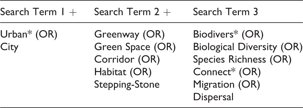
After the original search, terms associated with specific connecting features (e.g., road, green roof, garden) were added in place of Search Term 2 to ensure that no type of connecting feature was overlooked. This review was limited to English language literature and augmented with snowball sampling where necessary to fully address the research questions.
This study is also limited to features that allow animals to traverse the urban landscape. Habitat connectivity also impacts plants, both directly and through services provided by animals, such as pollination, seed dispersal, and pest control. Due to the connection between flora and fauna, many of the strategies that facilitate animal movement will also support plants. But other mechanisms of floral migration are different (Bennett 2003) and beyond the focus of this review. The same is true of aquatic biodiversity. Land use actions do impact the diversity and success of aquatic organisms, but they are not included in this study.
The search described above resulted in 114 books and articles relevant to urban habitat connectivity planning. Publications fall into five natural groupings (Table 1). These categories form the framework for the review that follows. The first section briefly describes the relationship between urban connectivity and biodiversity, and options for planners seeking to create or support functional habitat connections. Sections two through five describe the state of knowledge on the design and planning of each of those options: greenways and stepping-stones. The review concludes by identifying knowledge gaps and suggestions for future research.
Natural Groupings of Review Results and the Criteria for Inclusion in Each Category.
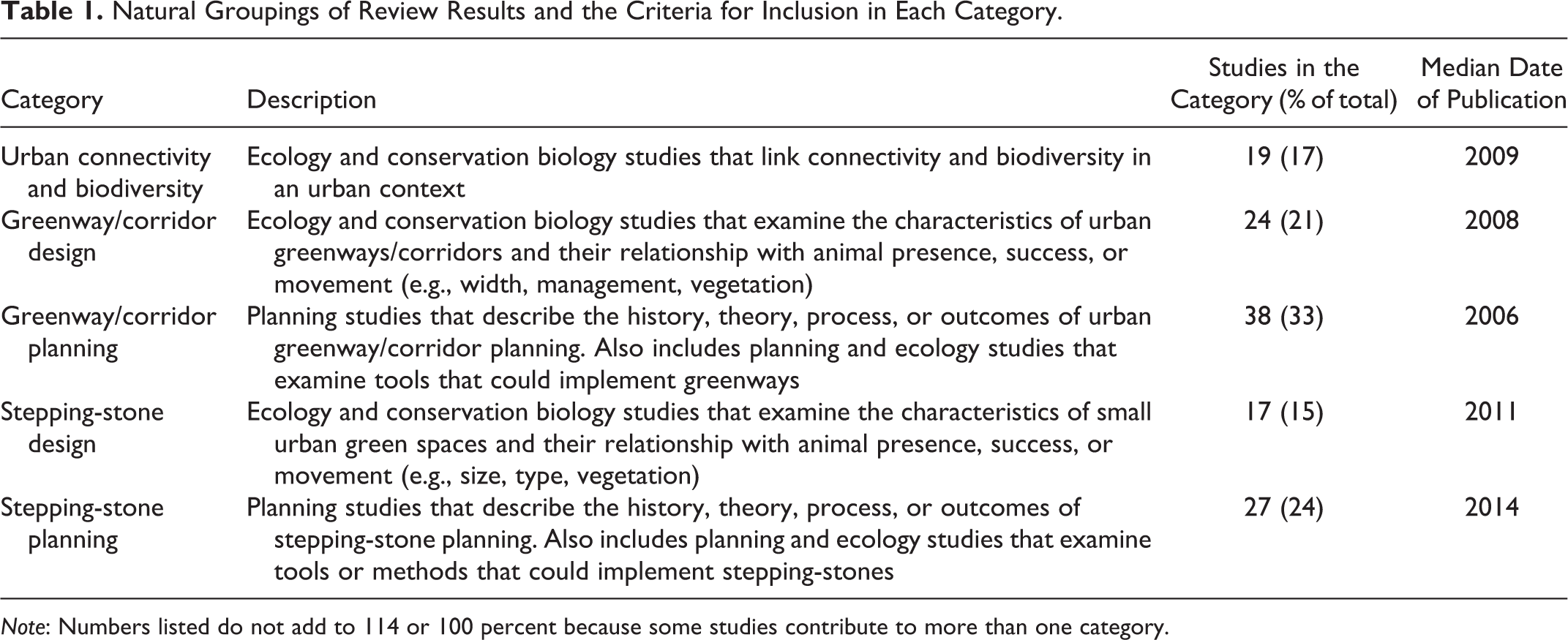
Note: Numbers listed do not add to 114 or 100 percent because some studies contribute to more than one category.
Urban Connectivity Supports Biodiversity
Habitat connectivity is often conceptualized as spatial continuity. The fewer the gaps in a habitat, the greater its connectivity (Forman 1995) and the more it facilitates the movement of wildlife (Crooks and Sanjayan 2006; Mitchell, Bennett, and Gonzalez 2013; Rudnick et al. 2012; Tishendorf and Fahrig 2000). A landscape with high connectivity is one in which organisms can move freely between suitable habitats, and a landscape with low connectivity is one in which their movement is constrained (Bennett 2003). But habitat connectivity can also be achieved without physical landscape continuity.
Structural connectivity describes the spatial arrangement of habitats in a landscape and their physical characteristics that impact movement. Measures of the landscape and characteristics that can be mapped fall into this category, such as the size and extent of gaps, vegetative cover, hydrology, development patterns, and average patch size. Functional, or behavioral, connectivity is how individuals and populations respond to the physical characteristics. Functional connectivity is a result of interactions between the characteristics of an organism and the structure of the landscape. In short, different species respond differently to the same physical environment (Rudnick et al. 2012; Bennett 2003). Because of this, “a structurally connected landscape may be functionally connected for some species and not for others” (Crooks and Sanjayan 2006, 3). But it also means that structurally disconnected habitat patches could be functionally connected, if organisms are able to move between them. This duality of connectivity creates a challenge for planners, researchers, and land managers, alike. One of the most significant results for planners, managers, and geographic information scientists is that landscape characteristics do not fully describe connectivity. Organism characteristics are as important. But it also provides an opportunity, particularly for urban areas. Spatially disconnected green spaces can be functionally connected.
Evidence from functional connectivity studies of carnivores (FitzGibbon, Putland, and Goldizen 2007), arthropods (Braaker et al. 2017), and birds (Kang et al. 2015) concludes that urban connectivity is strongly correlated with species richness and abundance. Authors highlight the importance of functional connections between habitat patches for species survival and suggest that restoring or preserving connectivity could enhance the diversity of particularly sensitive taxa like birds (FitzGibbon, Putland, and Goldizen 2007; Kang et al. 2015). Other studies outline the relationship between fragmenting urban land uses and the dispersal of organisms. For example, level of urbanization has a greater impact on the ability of sugar gliders—an arboreal species—to traverse the landscape than does the level of tree cover (Caryl, Katrina, and van der Ree 2013). Wildlife as diverse as bumblebees (Jha and Kremen 2013), prairie dogs (Magle, Theobald, and Crooks 2009), and toads (Hitchings and Beebee 1998) are also sensitive to urban fragmentation. Another category of functional connectivity study addresses the barrier effects of specific linear features such as roads and railways. Such features can impede the movements of sensitive species (Poessel et al. 2014; Tremblay and St. Clair 2009). These studies seek to understand what happens when fragmentation bars organisms from undertaking movements and migrations. Even studies of large, highly mobile carnivores find that roadways provide significant barriers (Poessel et al. 2014; Riley et al. 2006).
Urban Connectivity Strategies: Corridors and Stepping-stones
Strong empirical evidence suggests that functional habitat connectivity impacts urban species richness. Less clear is what functional connectivity looks like in developed areas. Creating sizable patches of habitat in urban centers is both infeasible and undesirable. Adding large amounts of green space would reduce the density of cities and its associated efficiencies. A more practical strategy is to create a configuration of green space that connects small habitats to each other and—more importantly—to core natural areas. There are two broad, conceptual strategies for creating these connections in fragmented landscapes: corridors and stepping-stones.
Corridors create structural connectivity. They are direct, linear connections between habitats. There has been significant debate over the years on whether organisms successfully use corridors or whether they lead to increased mortality (Beier and Noss 1998). The most recent consensus for urban areas is that they do create functional connectivity in otherwise fragmented areas (Vergnes, Kerbiriou, and Clergeau 2013; Munshi-South 2012; Lee and Peres 2008; Beier and Noss 1998). The other option, stepping-stones, is small islands of habitat that serve as refuges between larger habitat patches (Carbo-Ramirez and Zuria 2011; Fernandez-Juricic and Jokimaki 2001). To support animal dispersal, stepping-stones must be functionally connected, which means that organisms must be able to move through the landscape between the refuges (Baum et al. 2004). A recent and extensive meta-analysis indicates that corridors—structural connections—are more effective at supporting urban biodiversity than stepping-stone habitats (Beninde, Veith, and Hochkirch 2015). But evidence does support the benefits of stepping-stones, particularly where the landscape between patches is relatively benign. If corridors are not possible, stepping-stones could provide habitat that allows urban organisms to move across the landscape (Leidner and Haddad 2011).
A variety of urban green spaces can serve as corridors or stepping-stones. Munshi-South (2012), for example, found that small animals use environments as diverse as cemeteries, vegetated road medians, and forested residential areas to move between city parks. The list of candidates for corridors and stepping-stones in cities is long: greenways, cemeteries, public parks and gardens, road and rail corridors, spontaneous green space (vacant lots, brownfields), green roofs, residential gardens, and residential and commercial open spaces (Ignatieva, Stewart, and Meurk 2011). The following sections review research on the state of our understanding of how they can be planned and designed to foster the movement of urban wildlife.
Urban Greenway Corridors: Rivers, Rails, Roads, and Trails
In urban areas, the majority of open space corridors are referred to as greenways. Some cities and authors discuss corridors in urban areas without applying the term, but the features have similar characteristics (Hellmund and Smith 1996). Greenways are linear green spaces that typically follow natural or man-made features such as rivers or railways (Erickson 2004; Hay 1991; Viles and Rosier 2001). They are most common in cities and suburbs where natural green space and human contact with nature are limited (Hay 1991). William Whyte coined the term “greenway” in an urban context, in his 1959 book Securing Open Space for Urban America. Little (1990) presented sixteen greenway case studies and a cohesive movement thirty years later in Greenways for America. By 1995, there were over 500 greenways in the United States (Ignatieva, Stewart, and Meurk 2011). That year, Landscape and Urban Planning published a special issue on greenway planning, which was adapted into an edited volume, appropriately titled, Greenways: The Beginning of an International Movement (Fabos and Ahern 1996). Over twenty years later, we are firmly in the middle of that movement. Most major cities have greenways. Green wedges, for example, which predate the greenway movement and have a similar linear design, are popular among European communities (Lemes de Oliveira 2017). Greenway and trail organizations in the southeast and mid-America regions of the United States and states such as California and Pennsylvania organize annual conferences that attract hundreds of practitioners, mainly from the public and nonprofit sectors.
To many planners and urban dwellers, greenways bring to mind walking and biking paths (Bryant 2006; Hay 1991). In a survey of British greenway planners, just 37 percent identified “nature conservation and habitat creation” as a greenway project objective, while 74 percent selected recreation and leisure (Turner 2006). However, as Hay (1991) noted over twenty-five years ago, “A narrow hiking or bike path, lined with ornamental trees and mowed grass, is not a greenway…. Trails are not greenways unless…they are bounded on both sides by wide (wider than 50 feet) protected natural corridors” (p. 163). Few modern greenways meet these criteria. One way to resolve diverging greenway definitions and characteristics is to divide them into three types: ecologically significant greenways, recreation greenways, and cultural greenways (Fabos 2004). Some separate active transportation greenways from recreation corridors, but the design of the two is the same. There are a variety of other typologies (see Ahern 1995), but these cover the majority of green space corridors in urbanized areas.
The characteristics of a community’s greenways depend upon its goals, typically some combination of conservation, economic development, recreation, active transportation, and, most recently, community health. But, as Erickson (2004) notes, “While the three-legged stool of recreation, [active] transportation and conservation has supported greenway efforts across the continent, it is rare that each leg is equally weighted” (p. 219). Recreation components are attributes of most types of greenways, but are the double-edged sword of greenway planning, from an ecological perspective. A recreation element such as a trail builds public support for greenway development (Erickson 2004; Lindsey 2003). As William Whyte wrote in 1968, “…open space must have a positive function. It will not remain open if it does not. People must be able to do things on it or with it – at the very least, to be able to look at it” (p. 162). Public support is necessary to create a greenway system large and connected enough to support species movement. But if the public use components are too wide, disruptive, or trafficked, they can undermine the ecological benefits of the greenway. Recent evidence suggests that Erickson’s concern was well founded. Greenway and trail conference presentations from the past year (2017–2018) include all of the aforementioned goals—recreation, economic development, health, and transportation—and go a step further to consider equity and how cities might better connect low-income areas and communities of color to the networks. 1 The fewest presentations focused on conservation. Just two (at the 2017 and 2018 California Trails and Greenways Conferences) addressed habitat connectivity.
The defining feature of an urban greenway is not its location but its linearity. As greenway systems are increasingly connected regionally and across borders, they span urban and rural environments. The resulting systems have significant potential to create connectivity within urban landscapes and between fragmented urban green spaces and larger habitats at the periphery. Modern ecological greenway planners can take advantage of this potential to build networks based on landscape ecology, landscape architecture, and conservation biology principles (Ignatieva, Stewart, and Meurk 2011). But if communities do not prioritize conservation goals, these plans are unlikely to come to fruition. Another important factor is our understanding of how greenways can support wildlife movement and the most beneficial planning processes and corridor design characteristics.
Do Urban Greenways Create Connectivity?
Over the past twenty-five years, biologists and ecologists have examined the connectivity functions of several types of urban greenways. Publicly owned linear parks and riparian corridors are among the most studied. As previously discussed, the ability of a natural feature to support wildlife movement will depend upon the characteristics of focal species as well as the qualities of the green space. Consequently, a useful way to discuss the impact of greenways on animals is to divide studies into taxonomic groups: arthropods, mammals, and birds. These divisions are broad, but the groups have diverging dispersal characteristics, so they provide a general idea of greenway success in supporting animal movement.
For small species such as arthropods, the quality of habitat within greenways may be as important as any movement they facilitate (Angold et al. 2006; Chovanec et al. 2002). One study found that habitat patches that were connected to railway and river corridors had butterfly and beetle communities similar to those that were disconnected. The authors concluded that “for many species of invertebrates in the urban environment…good quality habitat is the key to their continued survival rather than the more difficult task of increasing habitat connectivity” (Angold et al. 2006, 203). But other research suggests that linear landscape elements do facilitate movement by arthropods and may be crucial in maintaining urban biodiversity (Van Rossum and Triest 2012; Vergnes, Le Viol, and Clergeau 2012). The results suggest that stepping-stone habitats impact arthropod movement, and corridors probably do, but the two could work best synergistically.
Evidence that linear landscape elements help small mammals move throughout an urban landscape is less equivocal. Several studies suggest that connectivity provided by urban greenways could be beneficial for small- to medium-sized mammals—particularly those with limited habitat availability and dispersal capabilities (Angold et al. 2006; Schiller and Horn 1997; Vergnes, Kerbiriou, and Clergeau 2013). A study of suburban Paris, for example, concluded that without vegetated corridors, the movement of shrews between habitats would be limited and shrew populations genetically compromised (Vergnes, Kerbiriou, and Clergeau 2013). Evidence for larger mammals depends upon the species in question (Vergnes, Kerbiriou, and Clergeau 2013). Some suggest that large mammals move between habitats with ease and do not benefit from greenway corridors (Angold et al. 2006). A study of thirty-eight greenways in the southeastern United States concluded that a primary factor in the presence of white-tailed deer within the corridor is connectivity to large-scale natural areas beyond the greenway. The authors conclude that some greenway segments are valuable for large mammals because they provide access to adjacent lands with high habitat value (Schiller and Horn 1997).
Greenways are also supportive of bird populations—both local and migrating. A study of vulnerable bird species in suburban North Carolina found that landscape connectivity was an important predictor of bird richness and abundance in greenways but not as significant as forest size and characteristics (Mason et al. 2007). A study in Tokyo compared three urban greenways with different vegetation profiles and found that the corridors were effective at facilitating the movement of most birds. They concluded that corridors with supportive vegetation structure, even if they were originally intended for recreation, are important factors in the persistence of urban bird species (Matsuba, Nishijima, and Katoh 2016). Greenways also serve as stopover locations for migrating birds. In another study of North Carolina greenways, migrating birds used greenways of all characteristics but were more abundant in wider corridors with greater vegetation complexity and interior habitat (Kohut, Hess, and Moorman 2009).
Research on the relationship between urban greenways and wildlife movement is oriented toward river, rail, and public trail corridors. This is unsurprising because urban greenways are most common in areas where green space is limited, and creating corridors along existing linear features or recreational amenities is a practical strategy. Studies on roadside and residential subdivision greenways also exist but are largely conceptual (Viles and Rosier 2001; Arendt 2004). Few studies examine the ecological differences between the types of greenways and whether one type may have advantages over others. This research could be useful for planners charged with deciding between multiple corridor options. For greenways with transportation features, such as railways, roads, or trails, the width of the feature could make a difference. Greenways built around narrow transportation pathways could support species movement more effectively than alignments with wider features. In one study of urban barriers, for example, railways allowed for the greatest passage by forest birds because the transportation component was the narrowest (Tremblay and St. Clair 2009). Other studies conclude that riparian areas are particularly associated with native bird presence (Palmer et al. 2008) and retain their high-quality native habitat in otherwise disturbed landscapes (Jim and Chen 2003; Parker et al. 2008). However, some evidence suggests that the quality or diversity of habitat in a greenway is more important than the type of corridor. In their study of a riparian corridor in England, Dallimer and colleagues (2012) suggest that the dynamics of urban riparian zones are no different from nonriparian zones, and that other forms of urban green space such as parks or “other linear features such as abandoned railway lines, could be equally able to enhance connectivity in urban settings” (p. 751). Given the spatial constraints of greenway routes in cities, ecological greenway planners may find this reassuring.
Linear Transportation Infrastructure: A Fourth Type of Greenway
One of the more pervasive modes of disturbance and fragmentation in urban areas is transportation, particularly roads. Yet transportation corridors are linear elements and often edged with trees or other managed vegetation. Several authors note the potential for roadsides to serve as greenways (Ignatieva, Stewart, and Meurk 2011; Jim and Chen 2003; Viles and Rosier 2001) Others do not use the term “greenway” but note similar potential connectivity benefits (Carbo-Ramirez and Zuria 2011; Davies, Frandsen, and Hockridge 2014; Fernandez-Juricic and Jokimaki 2001; Munshi-South 2012; Oprea et al. 2009; O’Sullivan et al. 2017). Linear transportation infrastructure such as roads, railways, and pipelines consists of a transportation lane and a “verge,” a vegetated strip around or on top of the alignment. Some also include power lines, canals, and navigable rivers in this category (Jeusset et al. 2016). Where verges are vegetated, they could create corridors that support species richness in adjacent areas, particularly if they are designed and managed to do so (Ikin et al. 2013; Saumel, Weber, and Kowarik 2016; Viles and Rosier 2001) or if they are no longer active (Foster 2014). A case study of an abandoned railway corridor in Paris, for example, notes that the “vacant” space has biodiversity comparable to the city’s two large woodlands and facilitates ecological connectivity along its length (Foster 2014). But active road corridors are much more common, particularly in urban areas, and the topic of most studies of transportation verges.
As with many facets of connectivity, the success of road verges in facilitating wildlife movement depends upon the vegetation and focal species. Studies of bats (Oprea et al. 2009), birds (Carbo-Ramirez and Zuria 2011; Fernandez-Juricic and Jokimaki 2001), and mammals (Munshi-South 2012) have concluded that road corridors could increase connectivity in urban areas, although the effect is not always strong (Oprea et al. 2009). But public roads also have safety and utility management standards that constrain management for wildlife (Carbo-Ramirez and Zuria 2011; Viles and Rosier 2001), particularly since native street vegetation is more supportive of some animals than exotic vegetation (Ikin et al. 2013). Two recent reviews (Davies, Frandsen, and Hockridge 2014; O’Sullivan et al. 2017) discuss the environmental benefits of transportation verges in the United Kingdom and identify management strategies such as tree retention and reduced mowing frequency, which could enhance their ability to support biodiversity. These strategies would also augment the verges’ ability to support species movement. While the body of evidence is still developing, existing information suggests that the relationship between transportation verges and connectivity is sufficient to create a fourth category of greenway, a transportation greenway.
Greenway Characteristics that Enhance Connectivity
Planners can support biodiversity by creating greenways that allow species to traverse the landscape and to access large, core habitat patches. The design of a conservation corridor determines many of its ecological benefits. As Noss and Harris noted in 1986, “In almost any landscape are linear or sinuous structures…that can potentially connect or sever landscape patches and nodes. Whether a given feature serves as a barrier or as a dispersal corridor depends on habitat structure within the corridor, corridor width, [and] the position of the corridor relative to habitat patches in the landscape” (p. 304). Based on a review of existing evidence, recommendations for greenways that support animal movement are identified below and discussed in the following section. These could be described as best practices of greenway design. Some of the actions (e.g., wide greenways with connections to core habitat areas) are well supported by empirical observations, and others (e.g., encouraging private landowners to manage their land as habitat) are frequently recommended but rarely examined.
Greenway planning recommendations: Create wide greenways with narrow trails that are located near the edge of the corridor. Manage greenway land as habitat, not just as a conduit between habitats. Encourage private landowners around greenways to manage their land as habitat. Provide stepping-stone habitats along the greenway corridor. Create greenways that go somewhere (i.e., connect larger habitat patches).
Many studies highlight the importance of width in the ability of greenways to support animal movement. A corridor should be wide enough to provide space for resources such as food and shelter, minimize disturbance from surrounding land uses, and facilitate travel between habitat patches (Parker et al. 2008). Yet studies on the minimum width standards for any type or location of corridor are rare (Harris and Atkins 1991; Lee and Peres 2008; Parker et al. 2008). The primary reason for this is probably the practical considerations of green space delineation in cities. Open space availability rather than a designer often dictates urban greenway widths (Parker et al. 2008). A second reason is that greenways should be designed to provide functional connectivity for a specific focal species, so the appropriate dimensions vary. Wider may not even be better for some species (Andreassen, Halle, and Ims 1996). Harris and Atkins (1991) note that, “the width of corridors should be gauged in units of the landscape, not simple, human-imposed numbers…a vegetation strip along a creek may be extremely great for small creatures [but]…totally useless for other species…” (p. 124). They go on to cautiously propose a scale running from a width of 30–300 feet (9–90 meters) for a few well-known species and short-term function to 3,000+ feet (900+ meters) for greenways that will support the movement of a broad number of species over the long term (Harris and Atkins 1991). All studies that discuss urban greenway width note that wider is better, and several do suggest minimum thresholds, particularly for bird populations. Austin (2012) suggests 10–30 meters for moderately human-adapted species, while Schiller and Horn (1997) classify greenways of less than 30 meters as narrow and greater than 30 meters as wide (Austin 2012).
Species that are more sensitive to disturbance will require wider corridors. One study found that interior bird species were not present in urban greenways narrower than 50 meters, and more sensitive species were only present in greenways wider than 300 meters. The authors suggest greenways wider than 100 meters (Mason et al. 2007). Another avian diversity study suggests that 150 meters or wider is most desirable (Kohut, Hess, and Moorman 2009). One way to add width without investing in additional greenway space is to encourage adjacent property owners to retain vegetation (Kohut, Hess, and Moorman 2009; Parker et al. 2008). Not only would this widen the effective greenway, but evidence suggests that adjacent land uses are a factor in the ability of greenways to support birds and mammals (Kohut, Hess, and Moorman 2009; Schiller and Horn 1997). Several authors recommend the strategy, but no peer-reviewed literature directly examines its implementation or outcomes.
Another factor in greenway planning is disturbance. Greenways are often designed to support recreation as well as wildlife, so many have landscaped, paved, and mowed areas (Turner 2006; Hay 1991). Evidence suggests that arthropods (Angold et al. 2006), birds (Mason et al. 2007), and mammals (Schiller and Horn 1997) can be impacted by disturbance from recreation uses of trails and paths. As Schiller and Horn (1997) note, the creation “of greenways can potentially reduce habitat value…if remnant urban wildlands are converted to highly managed greenways” (p. 114). More generalist species are present, and overall species abundance and richness is lower in greenway segments with more managed surface (Mason et al. 2007). The result is concerning but unsurprising. Avian and insect species are known to decline as impervious surfaces increase (Dallimer et al. 2012; Schutz and Schulze 2015). Mason and colleagues (2007) argue that greenways with small amounts of managed area may support up to twice as many development-sensitive bird species as those with two to four meter wide trails surrounded by a mowed area (p. 159). Narrow forest greenways with wide paved trails are also associated with high risks of avian nest predation (Sinclair et al. 2005). Planners can support development-sensitive species by minimizing the width of greenway trails and adjacent mowed, paved, and bare surfaces (Mason et al. 2007; Kohut, Hess, and Moorman 2009; Mortberg and Wallentinus 2000). One simple action would be to locate trails near the edge of a greenway instead of in the center (Mason et al. 2007). The action would maximize the width of the undisturbed area without impacting recreation uses. It is unclear whether this strategy has been adopted. It has not been examined empirically.
To support species movement, land within a greenway should be managed as habitat. Matsuba, Nishijima, and Katoh (2016) found that corridor vegetation could have a greater impact on corridor effectiveness than width. The risk of organism mortality can also be greater when a corridor does not provide important resources such as food and shelter (Parker et al. 2008). Ideally, a greenway network would protect a representative array of regional ecosystems (Flores et al. 1998). Forest cover is a prominent feature in many greenway ecology studies. Tree cover is often associated with species movement, abundance, and diversity (Harris and Atkins 1991; Kohut, Hess, and Moorman 2009; Mason et al. 2007; Matsuba, Nishijima, and Katoh 2016; Mortberg and Wallentinus 2000; Schiller and Horn 1997; Tremblay and St. Clair 2009). Many of the studies on corridor vegetation focus on sensitive bird species. Urban green space corridors that contain mature and decaying trees are supportive of vulnerable bird species (Mortberg and Wallentinus 2000). Another study suggests that tree cover and understory vegetation support the movement of sensitive, urban-avoiding birds. The latter could be problematic for greenway planners, as a thick understory can appear unmanaged or dangerous and undermine aesthetic and recreation values. The authors suggest a practical strategy of managing greenway vegetation based on the goal of individual segments. Corridors near large undisturbed green spaces could be managed for urban averse birds, and corridors near more developed land use for recreation and urban-adapted species (Matsuba, Nishijima, and Katoh 2016). The quality of green spaces that are adjacent to greenway corridors is also important. Corridors surrounded by natural land cover are more likely to support wildlife (Kohut, Hess, and Moorman 2009; Schiller and Horn 1997). One way to maximize the amount and quality of natural land cover surrounding a greenway is to ensure that it connects to large protected core habitat patches. Ideally, these core areas would serve as nodes and be located throughout a greenway network (Kohut, Hess, and Moorman 2009). Connections to larger habitat areas are associated with wildlife presence in a greenway (Schiller and Horn 1997) and critical in supporting species that are not adapted to disturbance (Austin 2012; Matsuba, Nishijima, and Katoh 2016).
Planning Greenways for Animal Movement
There are a variety of strategies for identifying, connecting, and preserving a network of greenway corridors (Ndubisi, DeMeo, and Ditto 1995; Arendt 2004). Use of a network concept in green space planning is positively associated with on-the-ground connectivity (Lynch 2016). Research also suggests that delineating corridors and patches in advance of development yields greater landscape connectivity and network attributes that are more supportive of goals such as biodiversity (Benedict and McMahon 2006). In growing suburban areas, preservation can occur along with development, for example, through conservation subdivisions and open space requirements, but the scale of the resulting greenways is still relatively small. Truly landscape-scale strategies are only feasible in rural and fringe areas where significant natural land is still available. Several techniques, however, can be applied or adapted to more urban areas. This section describes the state of knowledge of greenway planning for connectivity. The median publication date of the thirty-eight included studies (2006) is notable as the oldest in the review.
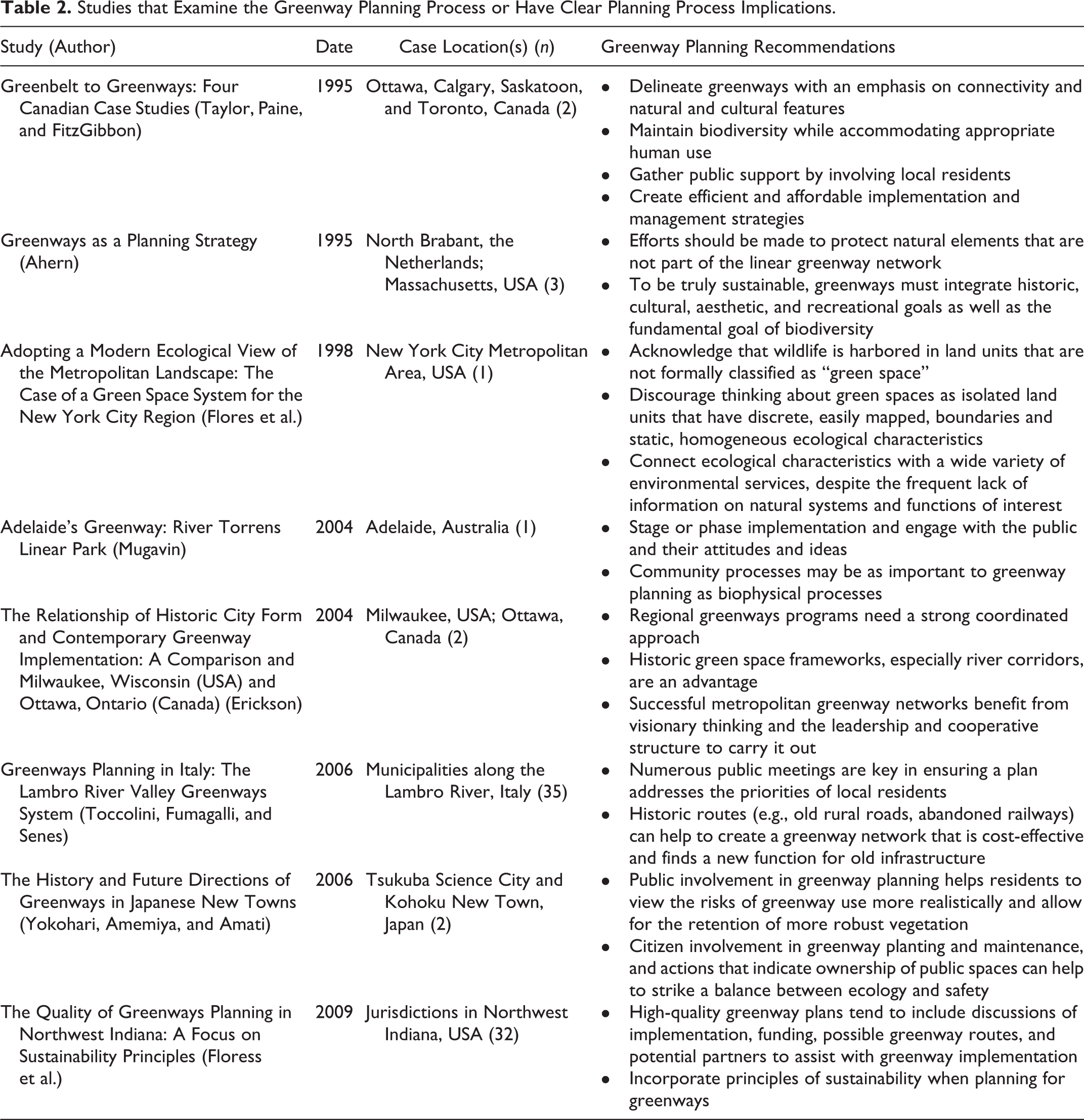
Greenway planning typically includes three steps: (1) identify important natural or cultural areas, (2) identify a network of greenways that includes or connects them, and (3) identify planning strategies to create and protect the network. Several studies also recommend public involvement as a standard greenway planning component, which enhances local support and could impact ecological outcomes (Mugavin 2004; Taylor, Paine, and FitzGibbon 1995; Toccolini, Fumagalli, and Senes 2006; Yokohari, Amemiya, and Amati 2006). Greenway planning process studies (Table 2) also highlight the importance of identifying avenues for implementation (Floress et al. 2009; Mugavin 2004; Taylor, Paine, and FitzGibbon 1995), balancing natural with cultural or recreation goals (Ahern 1995; Mugavin 2004; Taylor, Paine, and FitzGibbon 1995), and taking advantage of historic corridors such as rivers (Erickson 2004) and abandoned railways (Toccolini, Fumagalli, and Senes 2006).
Studies that Examine the Greenway Planning Process or Have Clear Planning Process Implications.
The first two steps in the greenway planning process can best be described as delineation. While there are many ways to accomplish the tasks, they are straightforward. The process involves data collection, mapping, analysis, and often modeling. The third step in the greenway planning process presents a greater challenge. Environmentally significant land is often privately owned. A Georgia study found that 75 percent of environmentally sensitive features that researchers identified for inclusion in a greenway network were located on private lands (Ndubisi, DeMeo, and Ditto 1995). As a consequence, supporting greenways in the long term is a complex issue. Communities can rarely acquire an entire greenway network from private landowners and must often prioritize the preservation of key segments (Ndubisi, DeMeo, and Ditto 1995). Furthermore, common land conservation tools such as conservation easements are more complicated if the land is planned for public use and are expensive to use near urban areas where land value is high. A larger issue is that studies oriented toward mapping greenways often stop short of identifying concrete strategies for retaining them, much less monitoring the strategies’ effectiveness. Perhaps as a consequence of this, most greenway planning studies emphasize delineation, few examine implementation tools, and even fewer directly assess the connectivity outcomes of greenway projects. Seven of the thirty-eight greenway planning studies included in this review are broad theoretical or historical texts. For ease of summary, I divide the remaining thirty-one into three categories: delineation, implementation, and outcomes.
A delineation study is one that proposes or demonstrates a process for identifying or demarcating a greenway. Of the thirty-one studies relating to urban greenway planning and connectivity, the largest number (fifteen) fall into this category (Appendix Table A1). These publications are well distributed over time and geographically. The features that guide greenway delineation depend upon the goals of the future corridors. Common ecological selections include riparian areas, wetlands, prime farmland, and wildlife habitat (Arendt 2004; Ndubisi, DeMeo, and Ditto 1995) but may also consider attributes such as size, current condition, stormwater needs, development pressure, and other locally important features (Conine et al. 2004; Oh, Lee, and Park 2011; Rudd, Vala, and Schaefer 2002). Orsini and colleagues (2014), for example, delineated greenway corridors that connect roofs that have the potential to support rooftop agriculture. For greenway projects with stronger recreation or cultural goals, characteristics could include potential pedestrian destinations such as residential areas, commercial centers, or recreation facilities (Conine et al. 2004; Rudd, Vala, and Schaefer 2002). Several planning studies emphasize the importance of balancing natural and cultural features and not overlooking the importance of culture and recreation in ecologically successful greenway planning (Ahern 1995; Mugavin 2004; Taylor, Paine, and FitzGibbon 1995).
Strategies for connecting greenway corridors also depend upon the overall goals of the network, but generally assume either the “core strategy” of connecting a few large habitat patches or the “node strategy” of connecting many small habitat patches, either with each other or with the core habitat patches (Orsini et al. 2014; Parker et al. 2008; Rudd, Vala, and Schaefer 2002; Zhang and Wang 2006). Many of these methods are technologically demanding and not frequently applied in practice. Least-cost path analysis is a core strategy and is often used for networks intended to facilitate wildlife movement (Hong et al. 2013; Oh, Lee, and Park 2011; Teng et al. 2011). Least-cost path analysis, as applied to species mobility, is a Geographic Information System (GIS) analysis that identifies the most likely (i.e., “least cost”) path for an organism between designated source and destination green spaces. The technique identifies a network of greenways that are likely to facilitate species movement between habitat patches. Integrating field survey data on indicator species could improve upon the strategy for urban areas (Hong et al. 2013). Other greenway mapping strategies, typically of the node variety, are network analysis and graph theory. Graph theory conceptualizes the environment as a series of nodes (e.g., habitat patches) and the links (e.g., greenway corridors) that facilitate flow between them. Network analysis describes these elements and their interrelationships and helps users to identify a network that maximizes desired characteristics such as interconnectivity (Hellmund and Smith 1996; Zhang and Wang 2006). The strategy can, for example, identify a network that creates the greatest connectivity between nodes such as public parks with the smallest number of preserved greenways (Zhang and Wang 2006) or between nodes that are the most ecologically significant (Rudd, Vala, and Schaefer 2002). A benefit of the node strategy is that connections to other natural areas buoy the ecological function of small ecological features (Jennings and Lev 1986). More multipurpose greenway models must integrate recreation, ecology, and cultural values (Conine et al. 2004; Teng et al. 2011). Models with recreation goals may incorporate data on greenway use or demand rather than the ability of wildlife to traverse the landscape.
Greenway projects in highly urbanized areas are likely to have a combination of recreation, cultural, and ecological goals and to be space constrained. In these environments, the delineation process described above will be challenging. Planners can accomplish multiple greenway goals in such environments, but they must take advantage of existing linear features such as roads, railways, and rivers (Erickson 2004; Jim and Chen 2003; Teng et al. 2011; Toccolini, Fumagalli, and Senes 2006). The width of available green spaces and linear features in such environments often dictates the size and location of greenways rather than the landscape itself (Parker et al. 2008). This practical and opportunistic strategy helps to address urban land cost and availability challenges (Teng et al. 2011). A greenway study in urban Australia found, for example, that the most continuous corridor scenarios included riparian areas that were set aside as drainage when the area was originally developed (Parker et al. 2008). Erickson’s study of Milwaukee and Ottawa further supports this strategy. She finds that a preexisting connected open space pattern can be retrofitted for social and ecological needs and “is an enormous asset on which to build contemporary greenway corridors” (Erickson 2004, 220).
Similarly, a study on the potential for an ecological network in a highly developed city in China identified a road corridor, city wall corridor, and a river corridor as possible greenways. The authors suggest that these greenways could serve both recreation and urban wildlife dispersal functions and connect to other scales of green space (Jim and Chen 2003). An additional benefit of including road verges is that they are within the public right-of-way and have one landowner: the government. Public ownership simplifies the acquisition, management, and maintenance processes. Public land can also foster connectivity in areas where private property owners are not participating in actions to support urban wildlife (Viles and Rosier 2001). Roads are pervasive in urban and suburban areas and thus could create an extensive corridor network if a community can create a wide enough verge and strike a successful balance between the disturbances of traffic and management for habitat (Viles and Rosier 2001).
Studies that delineate greenways, almost half of the greenway planning research described in this study, rarely identify specific strategies for preserving the corridors. Some suggest incorporating greenways into the comprehensive plan (Conine et al. 2004; Ndubisi, DeMeo, and Ditto 1995), which does not necessarily ensure protection, particularly when the information on what should be added is vague. Local plans, such as comprehensive plans, that guide greenway development tend to lack specific implementation recommendations (Floress et al. 2009). As the authors of a greenway plan quality study note, “Because implementation is the ultimate goal of planning, this aspect is one of the greatest strengths of excellent plans” (Floress et al. 2009, 70). The majority of plans they examined (70 percent) did not meet their standards for “excellent” and provided little to no discussion of actual implementation or funding. Even plans rated as “good” presented greenways as “more of a ‘good idea’ and less of a feasible option” (Floress et al. 2009).
Prominent options for protecting delineated greenway corridors are land acquisition, land use regulation (Erickson 2004; Taylor, Paine, and FitzGibbon 1995), development review (Erickson 2004; Maruani and Amit-Cohen 2009), incentives, and education (Maruani and Amit-Cohen 2009; Ndubisi, DeMeo, and Ditto 1995). Milwaukee, Wisconsin, limits development by preventing the extension of urban services into greenway corridors (Erickson 2004). Adelaide, Australia, found success with a phased, section-by-section approach (Mugavin 2004). Ndubisi, DeMeo, and Ditto (1995) surveyed local public- and private-sector stakeholders in a greenway planning project and found that most preferred regulatory measures. The rules typically require development permit applicants to satisfy a series of regulatory requirements (Ndubisi, DeMeo, and Ditto 1995). But Ndubisi also suggests that the large percentage of potential greenway land that is privately owned indicates that incentives and education would be more promising strategies.
More greenway protection strategies exist than are examined in peer-reviewed literature. As with several of the aforementioned greenway design best practices, implementation measures are quite often recommended but rarely examined for connectivity outcomes. As a result, the outcomes of many greenway implementation measures are unknown or unclear. It is difficult to tell where and how well they work, much less whether they are successful in creating greenways with the design characteristics that best support connectivity.
An implementation study is one that describes a specific strategy or tool for creating, protecting, or maintaining a greenway. Thirteen studies fall into this category (Table 3). In four of them, implementation is a relatively minor component. They identify or suggest implementation tools but do not examine them in any depth. Three are historic case studies that identify implementation tools and their outcomes indirectly. Viles and Rosier (2001) do directly discuss the benefits and challenges of roadways as an urban corridor strategy, but they suggest rather than assess the tool. The remaining eight studies are designed specifically to examine the effectiveness or potential of a tool that could implement greenways. Seven of those examine just one tool: conservation subdivision regulations. The eighth examines the success of riparian corridor protection policies in Israel. But while eight studies examine implementation tools, only half of those use ecological measures to understand connectivity outcomes.
Greenway Studies with Implementation Conclusions or Implications.
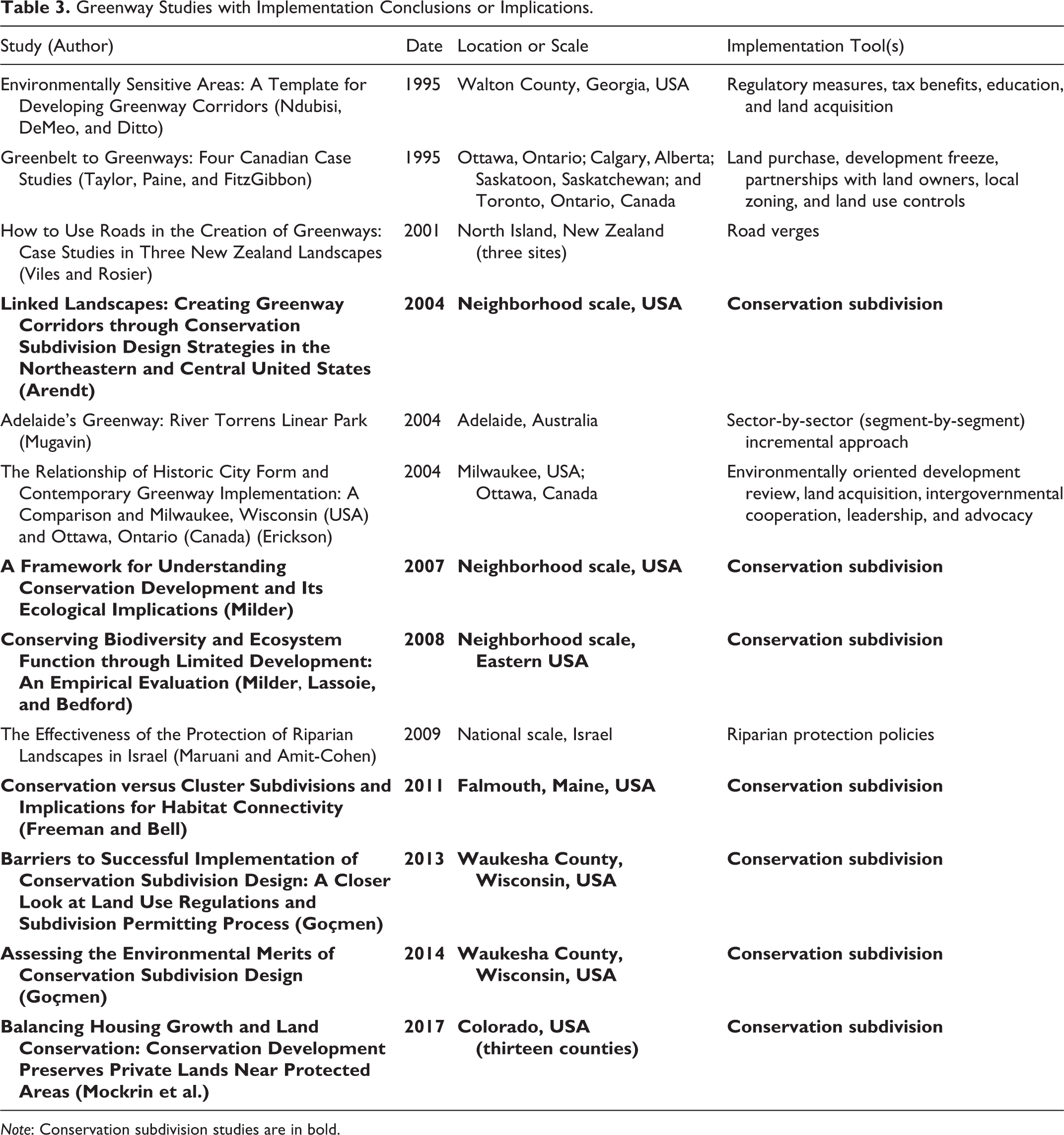
Note: Conservation subdivision studies are in bold.
Conservation subdivision strategies are only useful in undeveloped fringe areas but are prominent in the greenway planning literature. The seven studies included in this review suggest that the strategy has the potential to support connectivity (Arendt 2004; Ndubisi, DeMeo, and Ditto 1995). Furthermore, this literature has two remarkable qualities. First, four of the studies directly measure on-the-ground connectivity outcomes, a rarity in urban habitat connectivity research (Table 4). Second, these assessments comprise one of the few areas of strong overlap between urban planning and ecology literature. Studies of conservation subdivision developments are, for example, published in Conservation Biology and BioScience. It is unclear why research on this particular regulatory strategy has been able to bridge natural and social sciences research while others have not, but it can serve as a model. These studies suggest ecologists and conservation biologists recognize the impact and importance of land use planning tools.
Conservation Subdivision (Implementation) Studies that Directly Measure Connectivity Outcomes.
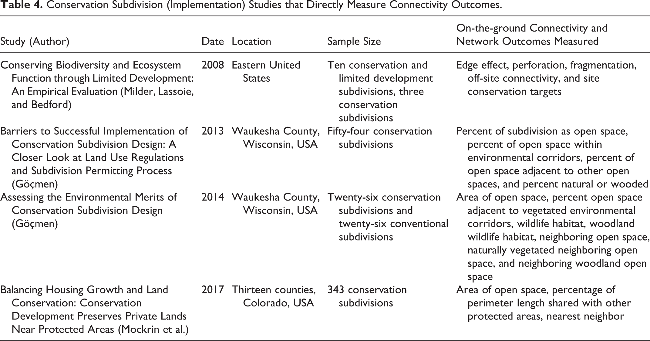
A conservation subdivision is a type of cluster development that delineates residential open space based upon the location of environmentally sensitive and important features (Arendt 2004; Göçmen 2014). If designed to be continuous, these ecological spaces could form effective corridors. The strategy has the most promise in fringe suburban areas with high development pressure. As the region develops, each new residential area would add a segment to a growing greenway network (Arendt 2004), effectively preserving important landscape features that would otherwise be developed. Evidence suggests that conservation subdivision design provides more functional landscape connectivity than conventional development and cluster development that is not based on natural features (Freeman and Bell 2011; Milder, Lassoie, and Bedford 2008). However, it is usually not the function of conservation development to implement a greenway plan. The strategy adds green space in an ad hoc, piecemeal manner.
Evidence supports the ability of conservation subdivisions to create and preserve connections between protected open spaces. Preserved open space within the subdivisions is often located adjacent to existing wildlife habitats, environmental corridors, and other conservation subdivision open spaces (Göçmen 2014; Mockrin et al. 2017). Mockrin and colleagues examined 343 conservation developments in Colorado and found that 76 percent were adjacent to at least one protected area. Variations of conservation subdivisions such as limited development projects appear to result in less green space fragmentation, more connectivity, and create refuges for wildlife (Milder 2007; Milder, Lassoie, and Bedford 2008). But the strategy does not necessarily create functional habitat (Hostetler and Drake 2009) or corridors. With natural features such as farmland, recreation trails, and steep slopes competing for consideration as preserved green space, retaining a wide corridor with diverse, high-quality habitat that supports organism movement could be a challenge. Connectivity with large core open spaces could also be an issue, particularly as development does not always occur with order and adjacency. Short greenway segments that do not connect to larger protected areas would have little value for species movement. In addition, as Hostetler and Drake point out in their 2009 review, planners and developers often focus on the design phase of conservation subdivisions and deemphasize the impact of construction and postconstruction management. As previously discussed, the management actions of private landowners and the quality and characteristics of green space have a significant impact on the ability of all types of wildlife to use and traverse a landscape. Furthermore, while conservation subdivision research is the most advanced of the implementation tools examined in this review, Milder (2007) finds that more “empirical work is needed to evaluate…the conservation outcomes of all four conservation development techniques” (p. 766).
While literature on the success of other regulatory implementation options is thin, two possibilities are zoning and riparian or floodplain regulations. Overlay zones that follow designated linear features, for example, could protect greenway corridors in the subdivision and land development process. Riparian buffers with vegetation and management requirements could assist in creating stream corridors that facilitate wildlife movement (Jim and Chen 2003; Parker et al. 2008). A study of riparian corridor protection policies in Israel suggests that protecting river corridors through local planning and permitting has limitations (Maruani and Amit-Cohen 2009). More research is needed on the effectiveness of these strategies for creating corridors and the width, habitat quality, and core green space connectedness that results.
Several additional strategies with significant potential are not traditional regulatory or public ownership-based protection but collaborative approaches where private landowners or groups of landowners such as horticulture clubs or community groups manage sections of a corridor system (Colding, Lundberg, and Folke 2006). Conventional public land preservation and regulation reinforces a dichotomy between conservation land and exploitable or private land that is not helpful in supporting biodiversity (Colding, Lundberg, and Folke 2006). As several delineation studies note, effective corridors are likely to include both public and private lands (Parker et al. 2008; Rudd, Vala, and Schaefer 2002). One option is co-production, a cooperative process between a government entity like a city and local citizens. Through co-production, local residents can help to fill the gap between what the city can provide and what is needed. These initiatives can work on large scales. A watershed stewardship program in Portland, Oregon, for example, resulted in 800 contributing organizations and 130 community projects including installations such as green roofs and bioswales, many of them on private property (Shandas and Messer 2008). Supported by a strong public planning process and municipal support, collaborative management could help to create more functional and biodiverse greenways. Given the visibility, popularity, and community benefits of greenways, they may be ideal candidates for co-production.
The final category of greenway planning studies is outcomes, encompassing both monitoring and assessment. Monitoring is often underemphasized in the planning process but can help to “close the loop” on planning and ensure that planning processes and outcomes continue to improve. Few studies examine the outcomes of greenway or urban corridor planning efforts. The deficiency is in line with a general lack of monitoring and empirical evaluation of urban green space plans (Ahern 2013). Gippoliti and Battisti (2017) note, for example, that “monitoring program[s] testing the effectiveness of ecological network plans using a project cycle logic are totally lacking, at least in a large part of Europe” (p. 687). Ten articles and chapters identified in this review examine the connectivity or habitat results of existing, on-the-ground greenways or green space networks and can be classified as outcome studies. Four of them examine conservation subdivisions and have already been discussed (Table 4). They are recent and based in the United States. The remaining six studies (Table 5) are more geographically diverse; only one examines a greenway in the United States. But all are more than ten years old.
Greenway Planning Outcome Studies.
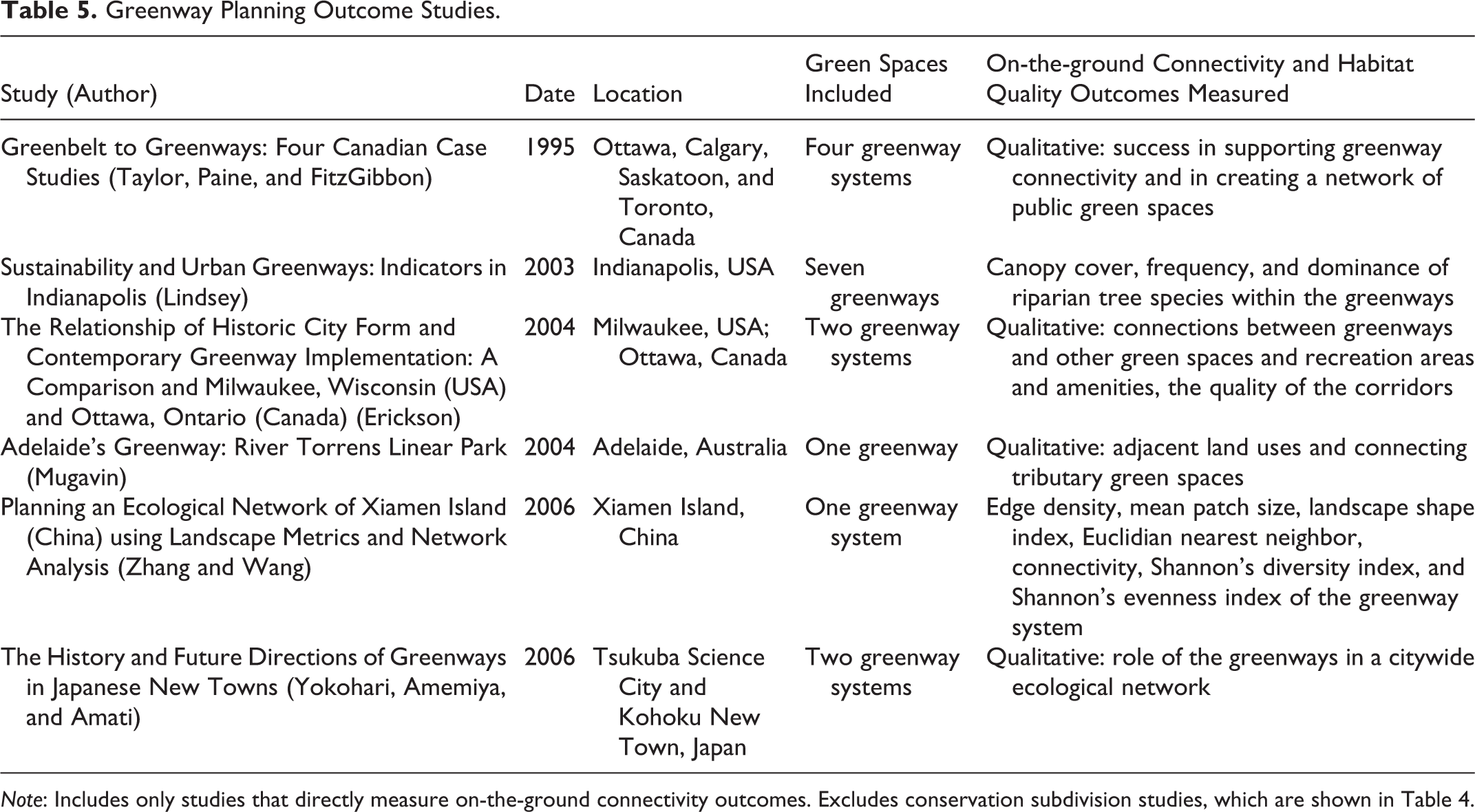
Note: Includes only studies that directly measure on-the-ground connectivity outcomes. Excludes conservation subdivision studies, which are shown in Table 4.
Of the six studies shown in Table 5, four are longitudinal, historical case studies that describe connectivity outcomes qualitatively and not as a major focus. Only two studies assess the habitat and connectivity outcomes of an existing, on-the-ground, greenway network. The more recent of the two, a 2006 article by Zhang and Wang, examines the landscape ecology of an existing and a planned greenway system. The goal of their study was not to assess the existing system but to understand the potential impact of the new plan and the utility of landscape metrics and network analysis. While this does not detract from the strength of their analysis, it does impact their recommendations, which look forward to the benefits of a new plan rather than closing the loop on the existing system.
A 2003 study more directly examines the results of a greenway system and is more similar to the types of outcome assessments that a community might conduct. Lindsey (2003) compares the goals and outcomes of Indianapolis’s seven greenways. A major goal of the greenways was to “Protect important wildlife and promote the conservation of open space, forest, and wetland areas” (p. 171). But the city did not systematically collect data on ecological indicators, so information on attributes such as canopy cover or vegetation diversity within greenways was unavailable. Indianapolis is not alone; few cities routinely collect ecological data (Berke 2007). In their study of the New York City region’s green space plan, Flores et al. (1998) note that their success in incorporating ecological knowledge into connectivity planning was “often limited by the availability of ecological information on the systems and functions of interest” (p. 307). A study of three New Zealand road corridors encountered similar challenges (Viles and Rosier 2001). The Flores study, however, goes on to note the existence of a “rich history of biological scholarship in some North American urban areas that is often glossed-over or underutilized in planning efforts” (p. 307).
Lindsey did make use of biological data collected through other studies. It was limited and covered only a few greenway segments but indicated that greenway ecosystems were degraded. Together, this and the general lack of environmental data suggest two things. First, greenways were not meeting ecological goals, and second, ecological conditions were not a particular emphasis of the Indianapolis Greenway Division, despite their stated conservation goal. Lindsey (2003) confirms that the data (or lack thereof) reflected the priorities of the Greenway Division. He notes that the Division sought to build user support for expanding the system by emphasizing recreation corridors over conservation corridors. While identified here as a monitoring and assessment deficiency, this is also an implementation issue. In scenarios where the multiple goals of urban greenways are competing, recreation objectives, the more visible of the two, can overtake conservation objectives. Erickson reports a similar shift with Milwaukee’s greenway system. The initial greenway corridors were protected to meet recreation and environmental objectives, but by 2004, recreation and active transportation were more important. This was despite the regional environmental quality goals that drive the broader corridor program (Erickson 2004). These types of shifts contribute to the erroneous view that greenways are merely trails.
Hundreds of communities are engaged in greenway projects, but no recent literature describes their ecological results, much less longer-term connectivity outcomes. None of the greenway studies that examine on-the-ground features use connectivity or habitat metrics comprehensively and all are over ten years old. With monitoring technologies constantly changing and new greenways being added and connected, literature from a decade ago has waning relevance to modern greenway planning. Research on conservation subdivision outcomes, however, does exist and draws upon a variety of connectivity and habitat metrics. Greenways have even more connectivity potential and would benefit from similar assessments.
Urban Stepping-stones: Parks, Yards, Green Roofs, and Informal Green Spaces
Nonlinear green spaces that are too small to function as core habitat can also play a connecting role in urban landscapes (Carbo-Ramirez and Zuria 2011; Fernandez-Juricic and Jokimaki 2001; Huang et al. 2015). A study of Beijing parks of various sizes concluded that small parks, for example, are valuable for conserving breeding birds and could provide important links within an urban green space system (Huang et al. 2015). Similarly, Hüse et al. (2016) finds that urban green spaces in Debrecen, Hungary, are clustered enough to allow species to disperse between them to reach ecological networks at the urban periphery. These spaces function as stepping-stones, which are used temporarily by sensitive birds and other urban-averse taxa moving through the landscape (Carbo-Ramirez and Zuria 2011; Fernandez-Juricic and Jokimaki 2001). The majority of literature on urban connectivity examines continuous corridors such as greenways. But a wide variety of species can be found in urban green spaces smaller than 2,000 square meters (Palmer et al. 2008; Rudd, Vala, and Schaefer 2002). Evidence suggests that many of these species do not require structural connections to disperse through cities (Angold et al. 2006; Chovanec et al. 2002; Leidner and Haddad 2011).
Stepping-stones have clear practical benefits in urban areas. Small green spaces do not require a substantial commitment of land and resources and are more available than continuous corridors. Leidner and Haddad studied the movement of a rare butterfly through a partially developed coastal area and compared the success of stepping-stone and corridor strategies. They concluded that both provided connectivity, but “given the logistical and financial constraints of establishing corridors in urban landscapes (Beier et al. 2008, cited by Leidner and Haddad), we believe stepping-stones offer a more realistic strategy” (Leidner and Haddad 2011, 1029).
The most common type of stepping-stone is an urban park or garden. Several studies show that urban and suburban gardens are as supportive of bumblebee species richness as rural areas (Osborne et al. 2008) and more so than some core green spaces (McFrederick and LeBuhn 2006). Other types of green space could also provide refuges. Research on the connectivity benefits of two types, informal green spaces and green roofs, is on the rise. Literature on the two is principally from the past five years.
Informal Green Spaces
An informal green space is a vacant site with unmanaged or spontaneous vegetation. Also known as wasteland (Bonthoux et al. 2014) or liminal green space (Rupprecht and Byrne 2014), the most common type is a brownfield, but wastelands also include vacant land and interstitial spaces such as railway and canal sidings. Due to their vegetation diversity and lack of management, wastelands support a variety of wildlife (Angold et al. 2006; Bonthoux et al. 2014). Research on the role that wastelands play in cities is still coalescing (see reviews by Bonthoux et al. 2014; Rupprecht and Byrne 2014), but current evidence suggests that wastelands support more species than managed urban green spaces such as parks and lawns (Bonthoux et al. 2014 and Rupprecht and Byrne 2014) and are sometimes biologically comparable to a city’s core natural areas (Foster 2014).
Large vacant lots and brownfields have characteristics that could make them effective stepping-stones, but this role of informal green spaces is understudied outside of transportation verges and local residents may find unmanaged areas undesirable or even unsafe (Burkholder 2012). Research does examine the role of abandoned lots and how shrinking cities can reclaim them for open space (Burkholder 2012; Frazier and Bagchi-Sen 2015). Frazier and Bagchi-Sen, for example, use landscape ecology metrics to inform a residential demolition strategy that increases green space connectivity. As the authors note, urban residential properties are typically too small (>0.1 acres) to be considered as part of a green space network (Frazier and Bagchi-Sen 2015). By aggregating them, the properties could provide more significant refuge to species passing through the landscape.
Green Roofs
Strong evidence suggests that green roofs also support urban habitat connectivity. Green roofs can be categorized as intensive or extensive. Intensive roofs have deep growing media and could be better described as rooftop gardens. They can support shrubs, trees, and even food production. Extensive roofs are lighter, less expensive, and more common. They have shallow growing media and most often a low-growing succulent called sedum. But extensive “biodiverse” green roofs are possible and can support grasses, flowers, or other small plants that can withstand the harsh roof environment. Because they are more common, most research addresses extensive green roofs. Studies of bats and arthropods conclude that green roofs are functionally connected to nearby ground-level green spaces (Braaker et al. 2014; Pearce and Walters 2012) and to each other (Braaker et al. 2014). As one would expect, connections between green roofs and surrounding features are most pronounced for high-mobility species such as bees and bats (Braaker et al. 2014; Pearce and Walters 2012), but species such as spiders are also functionally connected to ground-level vegetation (Braaker et al. 2014). Results suggest that green roofs function as nodes in urban ecological networks.
The green roof attributes that most contribute to their support of wildlife are site connectedness (Braaker et al. 2017) and vegetation diversity (Braaker et al. 2017; Pearce and Walters 2012). These characteristics matter more than the age, size, or design of the roof (Braaker et al. 2017). Furthermore, the connectivity role of green roofs can be augmented if green roofs are planned as part of an ecological network (Braaker et al. 2014). While field-based studies of intensive green roofs are absent, models suggest that they too can serve as stepping-stones or nodes in a green infrastructure network (Orsini et al. 2014). Orsini and colleagues (2014) argue that rooftop gardens designed with appropriate shelter and vegetation can support beneficial species such as pollinators. They go on to map out a corridor system that connects rooftops with garden potential (i.e., flat) to each other and to core green spaces at the urban periphery using ground-level features such as street trees.
Stepping-stone Characteristics that Enhance Connectivity
Evidence suggests that planners can support biodiversity by creating a series of stepping-stone habitats that help organisms to traverse the landscape and to access core habitat patches. Actions and characteristics that will augment the function of stepping-stones are identified below and discussed in the section to follow. Several of the characteristics are similar to those that support species movement through greenways (e.g., diverse, native, structurally complex vegetation), but others (e.g., taking advantage of informal green spaces) are distinct.
Stepping-stone planning recommendations: In more developed areas, create larger stepping-stones at closer intervals. Stepping-stone vegetation should be diverse, native, and structurally complex. Where possible, allow informal green spaces to remain minimally managed. Create stepping-stones that go somewhere (i.e., lead to larger habitat patches). Encourage private landowners in key areas to cluster gardens and manage their land as habitat.
Stepping-stones best facilitate the dispersal of species that are able to traverse some distance through an urban area (Leidner and Haddad 2011; McFrederick and LeBuhn 2006). Corridors are continuous, but stepping-stones are surrounded by other land uses. The ability of an organism to migrate from one small habitat patch to another therefore depends upon its ability to move through the intervening landscape. For flying organisms, the distance may not be limiting. Urban birds forage in tree patches as far away as 85 kilometers (Hostetler and Holling 2000). But terrestrial organisms move more slowly and must pass directly through nonhabitat areas. A reasonable dispersal distance for small mammals from patch to patch, through a corridor, or in the open, for example, is just one kilometer (Bennett 1990). Some put that value far lower, at 100 or 200 meters (Hüse et al. 2016). Baum and colleagues (2004) suggest that both stepping-stones and corridors support high levels of connectivity when the intervening land—the matrix—does not provide significant resistance to species dispersal. In environments where the matrix is hostile to the species of concern, corridors are a better choice. But if an animal can successfully traverse the spaces between patches, stepping-stones may be sufficient. The result suggests that stepping-stones should be closer in environments where the matrix is difficult to traverse, such as an urban center, but farther in suburban areas, which are greener and more generally supportive of animal movement. A second implication is that stepping-stones are likely to be unsuccessful at facilitating movement in environments that are hostile to wildlife. In these areas, the structural connectivity afforded by corridors is necessary. Planners should consider the matrix and mobility characteristics of local species of concern and strike a careful balance with refuge locations.
Area of green space is also important and has a strong positive association with bird species richness (Carbo-Ramirez and Zuria 2011; Fernandez-Juricic and Jokimaki 2001; Schutz and Schulze 2015; Strohback, Lerman, and Warren 2013). Minimum thresholds for a successful stepping-stone are commonly set between 1,000 and 2,000 square meters (Palmer et al. 2008; Rudd, Vala, and Schaefer 2002), although habitats smaller than 2,000 square meters may support mainly disturbance-tolerant species (Palmer et al. 2008). Very small green spaces are predominately edge habitat, which even in optimal vegetation conditions facilitates predation and disturbance (Fernandez-Juricic and Jokimaki 2001; Schutz and Schulze 2015). So while sensitive species may be attracted to small urban parks and gardens, use of the areas could lead to increased mortality (Carbo-Ramirez and Zuria 2011). This result indicates that a patch of habitat can be “too small” to serve as a refuge and that every effort should be made to create and retain larger green spaces in the development process and to increase the size of very small green space patches (Palmer et al. 2008). This also impacts stepping-stone placement. Small patches must be placed where organisms from larger core green spaces can continually repopulate them (Rudd, Vala, and Schaefer 2002). More ecological studies are needed to understand how successfully small green spaces support wildlife (Carbo-Ramirez and Zuria 2011) and the appropriate size for functional urban stepping-stones in different environments and for various species of concern.
Another important characteristic of stepping-stones is vegetation diversity. Evidence suggests that increasing vegetation diversity and complexity enhances species diversity in small green spaces (Belaire, Whelan, and Minor 2014; Fernandez-Juricic and Jokimaki 2001; Palmer et al. 2008). Bird communities appear particularly affected (White et al. 2005). Vegetation diversity is also an important factor in the ability of green roofs (Braaker et al. 2017) and informal green spaces to support of wildlife (Angold et al. 2006). Angold and colleagues (2006) argue, for example, that planners could best support urban connectivity and biodiversity “by not hurrying to tidy up and redevelop brownfield sites” (p. 203). These results suggest that maximizing the plant diversity of stepping-stones can make them more effective at providing refuge services and consequently at facilitating animal dispersal. But while informal green spaces are appealing to animals, humans may not find them attractive. Local residents may see unmanaged land that could attract crime or pests and reduce property values. Some research exists on integrating informal green spaces into formal environments in a way that legitimizes them (Burkholder 2012), particularly in the field of landscape architecture. More is needed to connect this work to planning.
Native vegetation is also important. As White and colleagues (2005) put it, “remnants of native vegetation act as vital refugia of indigenous fauna in the urban landscape” (p. 133). Evidence indicates that native vegetation facilitates the movement of species through an urban landscape to a greater extent than exotics (White et al. 2005). A variety of studies suggest that public and private individuals can support stepping-stones by planting native vegetation in refuge areas (Beumer and Martens 2016; Hüse et al. 2016; Ikin et al. 2013; Leidner and Haddad 2011; Mason et al. 2007; Parker et al. 2008; White et al. 2005).
Planning Stepping-stones for Animal Movement
Stepping-stones are smaller and simpler to create, retain, and manage than larger linear features. Most cities already have a variety of them, in the form of small public parks, residential yards or gardens, and other vegetated areas. Literature on urban stepping-stones is still developing. Most (79 percent) of the forty-two stepping-stone publications included in this review are from the past decade. The median publication date of the twenty-seven planning-oriented studies is 2014, the most recent of the five categories. Many of these examine ecological value or potential. The most common research question is some variation of “does (or how does) this type of small green space support local biodiversity?” Ten studies go further to identify the role of the stepping-stones in supporting habitat connectivity (Table 6), but connectivity is rarely the subject of the analysis. Just two European studies (Braaker et al. 2014; Ioja et al. 2014) directly examine the role of the focal green space in connecting urban habitats.
Stepping-stone Studies with Connectivity Conclusions or Implications.
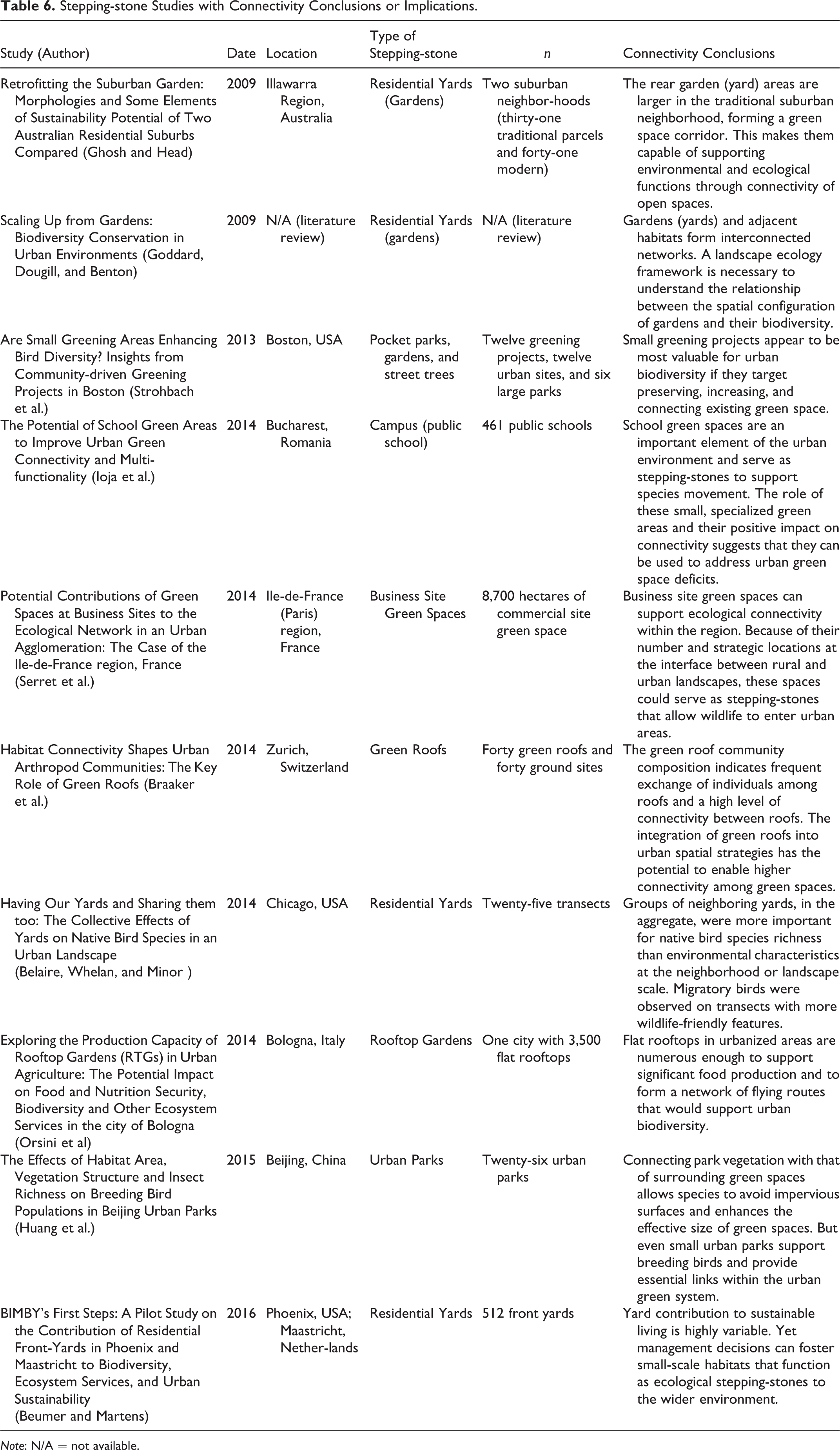
Note: N/A = not available.
One method for distributing small green spaces throughout an urban landscape is to use existing well-distributed public features such as school yards. A study of Bucharest, Romania, found that public school green spaces served as stepping-stones that increased the connectivity of the city’s green infrastructure (Ioja et al. 2014). Other studies suggest that college campuses (Alexio et al. 2014) and commercial green spaces (Serret et al. 2014) can also serve as refuges for urban wildlife and facilitate movement to more supportive habitats.
Another strategy is to take advantage of residential gardens. A large percentage of land in suburban communities is yard space, so it is unsurprising that conservation network models often include residential green spaces (Rudd, Vala, and Schaefer 2002; Parker et al. 2008). Studies of residential subdivision configurations find that many traditional gridded developments have mature trees and backyards that connect to form blocks of vegetated open space (Ghosh and Head 2009). But management is still an issue. Many yards are lawns, which are monocultures, and do not support urban wildlife. Intensive management can also stress and disturb animals (Beumer and Martens 2016). But if managed to support wildlife, gardens can serve as effective stepping-stones and form nodes in a broader conservation network (Goddard, Dougill, and Benton 2009; Rudd, Vala, and Schaefer 2002; White et al. 2005).
Gardens are commonly clustered in residential neighborhoods, particularly among adjacent properties (Hunter and Brown 2012). Due to their size, groupings form more ecologically significant stepping-stones than isolated gardens. A study of the Chicago area by Belaire, Whelan, and Minor (2014) found that groups of yards were more important for native bird species richness than neighborhood- or even landscape-scale environmental characteristics. Planners can support biodiversity by encouraging landowners to cluster gardens and to create gardens near adjacent habitat areas such as parks (Goddard, Dougill, and Benton 2009). Landowners can further facilitate habitat connectivity by creating gardens with supportive characteristics such as native vegetation in locations where a need for stepping-stones is identified (Belaire, Whelan, and Minor 2014; Beumer and Martens 2016; Ikin et al. 2013; Leidner and Haddad 2011; Mason et al. 2007; Parker et al. 2008).
Given the number of stepping-stones needed to provide connectivity in large urban areas, some level of co-production of urban refuges will be necessary. As with corridors, programs that encourage landowners in key areas to manage their land for habitat effectively expand conservation networks without the need for public land acquisition and management. In one of the few stepping-stone studies to examine an implementation strategy, Hunter and Brown (2012) suggest that social contagion is at play in the clustering of residential gardens and could be used as a mechanism to spread sustainable practices and create the groupings needed to support biodiversity. A variety of initiatives by nonprofit organizations support biodiversity on private property through programs that acknowledge homeowner efforts. The National Wildlife Federation, for example, consults with property owners on characteristics that support wildlife and certifies private landscapes that provide necessities such as food, water, and cover as “Certified Wildlife Habitat” (2018). However, an examination of the program by Widows and Drake (2014) noted “little to no connectivity between certified yards or between certified yards and larger areas of protected habitat” (p. 37). Connectivity was not the subject of their study, but the finding suggests that more purposeful planning will be necessary to create functional clusters of private habitat.
While no literature directly links them to connectivity, development regulations can also support stepping-stones. Local ordinances impact the type and extent of vegetation in new developments and could be used to retain trees and encourage native plantings. To manage stormwater, cities also increasingly incentivize or require decentralized stormwater facilities such as rain gardens and green roofs. Like stepping-stones, the effectiveness of these natural stormwater solutions may be dependent upon their critical mass and distribution throughout the landscape (Roy et al. 2008). The same network that manages stormwater could support wildlife. Research on green roofs confirms their role in urban connectivity (Braaker et al. 2014) and rain gardens, while smaller, typically include dense and diverse vegetation and could also play a role.
Stepping-stones are typically added opportunistically rather than through an ecological network planning process. But, like corridors, stepping-stones are most effective at supporting species when planned as part of a broader network (Braaker et al. 2014; Goddard, Dougill, and Benton 2009; Strohback, Lerman, and Warren 2013). Goddard, for example, highlights the role of a structurally disconnected, but functionally connected, network of residential gardens in supporting urban bird populations (Goddard, Dougill, and Benton 2009; White et al. 2005). The challenge for planners is that very few studies directly examine the role of stepping-stones in a network. This review identifies only four.
Two studies (Rudd, Vala, and Schaefer 2002 and Parker et al. 2008) examine stepping-stones as a step in the process of delineating habitat corridors. In Parker et al.’s (2008) study of urban Australia, the authors use rapid assessment methodologies to identify “conservationally significant stepping-stone sites” between two core habitat patches and the corridors that could connect them (p. 49). Rudd and colleagues (2002) use network analysis to examine the patterns of corridors necessary to link urban green space nodes in greater Vancouver, Canada. They concluded that smaller nodes provide important peripheral habitat and consider their most appropriate position in the habitat network. Other urban network analyses use similar strategies to highlight the role of nodes such as green roofs and public parks in providing functional connectivity in urban areas (Huang et al. 2015; Orsini et al. 2014), but they are limited by a focus on just one type of green space.
A 2016 study of Debrecen, Hungary, examined the role of a variety of discrete public and private green spaces in supporting urban biodiversity. The authors found that 65 percent of structurally disconnected urban habitat patches are within a reasonable dispersal distance and consequently close enough to be functionally connected. This creates the possibility for species to disperse between them and to connect to broader ecological networks at the urban periphery. They suggest that including ecologists in the process of urban development can facilitate these connections (Hüse et al. 2016). An earlier study by van Langevelde, Claassen, and Schotman (2002) modeled two conservation strategies for human-dominated areas: enlarging existing core green spaces and allocating stepping-stones between the sites. They found that both models increase the percentage of occupied habitat, but stepping-stones are more important where the amount of habitat available for animals is relatively low. In this situation, small green spaces increase functional connectivity and consequently the population of empty patches. Stepping-stones are less useful when good habitat is widely available (van Langevelde, Claassen, and Schotman 2002). To this, Rudd, Vala, and Schaefer (2002) add that smaller habitat nodes have higher rates of extinction and require close proximity to core habitat areas to replenish them. As fragmentation increases, smaller nodes become farther away, making dispersal difficult. Together, Rudd and van Langevelde suggest that stepping-stones are most useful in areas with a moderate level of fragmentation. When small nodes are too dispersed, they cannot be replenished and when good habitat is plentiful they are unnecessary. Research that could provide further clarification on the level of fragmentation at which for stepping-stones would be most helpful would benefit planners. Where, for example, are these spaces typically located along the urban–rural continuum? An answer to this question could help prioritize future stepping-stone research and green space funding and programs.
Urban Connectivity Research Needs
Much of an urban community’s habitat connectivity strategy will depend upon practical considerations such the pattern of land use and ownership and availability of core habitat areas. But even the most urban of cities has remnant habitat and managed or unmanaged green spaces that could be used to support connectivity. Evidence from this review of 114 planning and ecology studies shows that vacant lots, small parks, rail corridors, riparian greenways, road verges, and many other urban spaces can facilitate the movements upon which faunal biodiversity depends. These are spaces of ecological opportunity. Many of these areas are already publicly owned and need only be folded into a larger network strategy and managed as habitat. Ecology and conservation biology research can guide these actions. This is particularly true of stepping-stones, which are often undervalued or overlooked as an urban connectivity strategy. Yet this review also finds that few studies examine the results of local or regional efforts to create greenways and stepping-stones and even fewer monitor the long-term outcomes. Research is particularly needed in four areas.
The Implementation and Impacts of Best Practices
Research in the fields of ecology and conservation biology suggest a variety of design strategies for creating functional habitat connectivity in urban and suburban areas. This review summarized the findings into two sets of best practices that could enhance the connectivity outcomes of greenways and stepping-stones, respectively. Among them, connecting features should be managed as habitat, rather than paths between habitats, and include vegetation that is as diverse, native, and structurally complex as possible. One way to accomplish this is to allow informal green spaces such as vacant lots to remain minimally managed. When complex vegetation is not feasible along the entire length of a greenway, patches of high-quality habitat can support species movement. Communities should also encourage private landowners to manage land along greenways and within their own yards and gardens as habitat to create functionally larger stepping-stones and wider corridors. Ecology research further highlights the importance of connecting greenways and stepping-stones to larger core habitat patches. To facilitate access to these spaces and among patches of green space, stepping-stones should be larger and closer in more developed areas, and greenways should be as wide as possible with narrow active transportation lanes that are located near the edge of the corridor rather than the center.
But while ecological research suggests that connecting features incorporate these characteristics, planning studies rarely examine their implementation and impact. Planning literature, for example, does recognize the need for connections between greenways and core habitat areas, but the emphasis results mostly in conceptual delineation studies. Research rarely describes communities’ success in creating actual, functional connections to larger patches. Vegetation management is also a frequent recommendation in both planning and ecology literature. But few studies examine associated planning strategies or the degree to which resulting green space networks incorporate diverse, native, and structurally complex spaces. Many greenways, for example, are mown for practical and safety reasons. For stepping-stones, spacing is also an unknown. Generally, closer is better. And to an extent, the spacing of stepping-stones depends upon the species of concern. But research by van Langevelde, Claassen, and Schotman (2002) and Rudd, Vala, and Schaefer (2002) suggests that there is a moderate level of development in which they could be particularly effective. Studies of communities that have adopted a stepping-stone approach could help to illuminate the effectiveness of the strategy in various conditions and create models that would encourage implementation.
Best practices that depend upon the actions of private landowners have great potential but are also understudied. When landowners vegetate the spaces adjacent to greenways, parks, and private gardens, they increase the effective size of conservation features. Programs that encourage property owners to create habitat, such as the National Wildlife Federation’s certified habitat program, enhance human contact with nature and add to wildlife space without the need for additional public land acquisition. But additional incentives may be needed to ensure that individual landowner decisions add up to an ecologically sound whole. For greenways, private management actions could work well because public ownership is most necessary for recreation access. Communities could feasibly acquire narrow greenway trail corridors and create wide vegetated buffers around them through private land management. Trail users would enjoy visual access to the space, and animals could make use of additional private greenway width with minimal human disturbance. These types of strategies are promising, but more research is needed to understand their feasibility, implementation, and level of success in supporting connectivity goals.
Corridor and Stepping-stone Implementation Strategies
A significant deficiency in urban connectivity planning research is implementation. It is particularly notable for greenways. The purchase of land in-fee is the simplest and most expensive way to create corridors, but there are a variety of regulatory, partnership, and private land management possibilities. Riparian regulations and greenway co-management, for example, have potential but are understudied. One tool that does appear regularly in urban connectivity planning literature is conservation subdivision design. Ecologists, not planners, have conducted about half of existing research on the strategy. While the strategy itself has significant limitations, the shared interest in the outcomes of a land use tool is promising. More research is needed on how land use and land management tools can create effective corridors and stepping-stones, from both a planning and an ecological perspective. Studies that examine the effectiveness of implementation strategies at creating connective features with best practice characteristics are particularly needed.
The Characteristics and Outcomes of On-the-ground Connectivity Features
The most significant gap in urban connectivity planning research is the lack of information on outcomes. Stepping-stones are a relatively new addition to planning literature, so the lack of outcome assessments is unsurprising. There are few, if any, planned stepping-stone-based networks to examine. But the absence of recent greenway outcome assessments is more remarkable. The problem is not a lack of subjects. If urban plans and designs have sought structural connectivity since the eighteenth century, there is much to study. Revisiting former research sites, for example, would be illuminating. Even short-term studies that examine whether greenway plans lead to landscapes that support wildlife or whether riparian regulations create ecologically sound corridors would add significantly to the field.
This review could identify no study of the ecological results of an on-the-ground greenway that has been published in the past ten years. Only one, from 2003, attempts to close the loop on greenway planning by comparing a project’s conservation goals to its outcomes (Lindsey 2003). That study did not examine connectivity and relied upon incomplete secondary data. There are two possible explanations for the lack of greenway outcomes in the literature. Planners—academics or practitioners—are not performing these studies or they are conducting the assessments for internal use but not publishing them. Either is possible, but a brief review of the presentations at greenway and trail conferences suggests that the former is more likely. As previously discussed, very few presentations address habitat connectivity. In addition, both planning and ecology literature do assess the configuration of conservation subdivisions, so connectivity outcome studies are achievable and can produce meaningful results.
Shifting Greenway Goals
Some evidence suggests that the goals of greenway planning have changed over time from conservation to recreation and active transportation (Erickson 2004; Lindsey 2003). But many greenway planning studies are over ten years old or are historical longitudinal studies, which makes it difficult to track shifts in goals. The lack of connectivity outcome studies suggests there has been at least some movement away from ecological objectives. If greenway goals have shifted from conservation to recreation or active transportation, the impacts on urban habitat connectivity could be significant. Recreation greenways have a different configuration than ecological greenways, with more mowed and paved area and less green space. The “green” aspects of trail or bike path networks will derive from improvements in areas such as energy consumption, air quality, and public health rather than natural green space. More research is needed on current greenway planning goals and how recreation can be balanced with ecology. A 2016 study, for example, suggests that different segments of the same greenway can be managed to meet different goals (e.g., biodiversity, recreation; Matsuba, Nishijima, and Katoh 2016). As greenways become more popular, and consequently more extensive and interconnected, they will have a greater capacity to support goals such as economic development and public health but also to connect urban habitat patches and core green spaces. Currently, there is no evidence of communities taking advantage of this opportunity. More research on both greenway and stepping-stone strategies could help communities to revalue urban habitat connectivity and adopt planning goals and strategies that support biodiversity and balance the needs of wildlife and humans.
Footnotes
Appendix
Greenway Planning Delineation Studies.
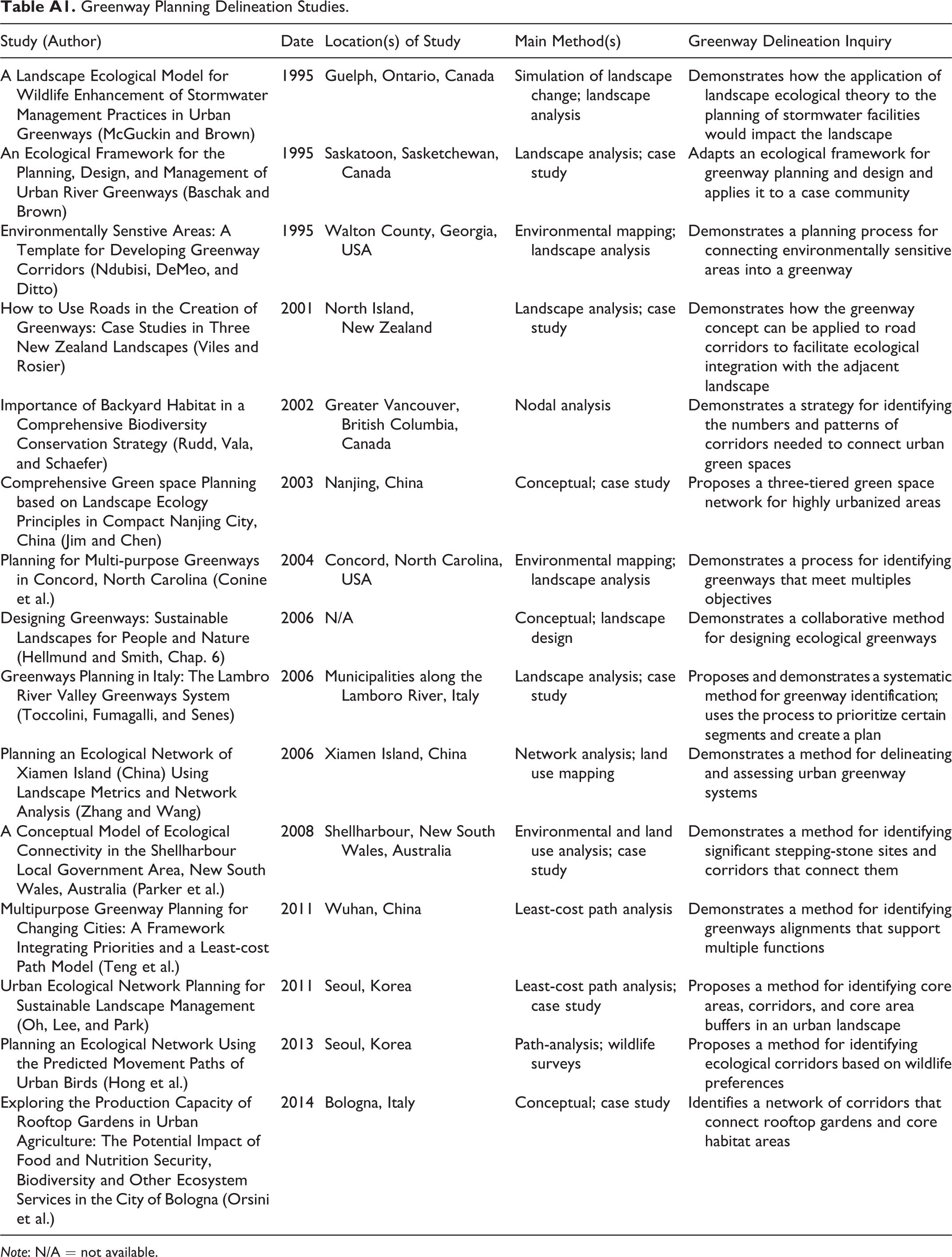
| Study (Author) | Date | Location(s) of Study | Main Method(s) | Greenway Delineation Inquiry |
|---|---|---|---|---|
| A Landscape Ecological Model for Wildlife Enhancement of Stormwater Management Practices in Urban Greenways (McGuckin and Brown) | 1995 | Guelph, Ontario, Canada | Simulation of landscape change; landscape analysis | Demonstrates how the application of landscape ecological theory to the planning of stormwater facilities would impact the landscape |
| An Ecological Framework for the Planning, Design, and Management of Urban River Greenways (Baschak and Brown) | 1995 | Saskatoon, Sasketchewan, Canada | Landscape analysis; case study | Adapts an ecological framework for greenway planning and design and applies it to a case community |
| Environmentally Senstive Areas: A Template for Developing Greenway Corridors (Ndubisi, DeMeo, and Ditto) | 1995 | Walton County, Georgia, USA | Environmental mapping; landscape analysis | Demonstrates a planning process for connecting environmentally sensitive areas into a greenway |
| How to Use Roads in the Creation of Greenways: Case Studies in Three New Zealand Landscapes (Viles and Rosier) | 2001 | North Island, New Zealand | Landscape analysis; case study | Demonstrates how the greenway concept can be applied to road corridors to facilitate ecological integration with the adjacent landscape |
| Importance of Backyard Habitat in a Comprehensive Biodiversity Conservation Strategy (Rudd, Vala, and Schaefer) | 2002 | Greater Vancouver, British Columbia, Canada | Nodal analysis | Demonstrates a strategy for identifying the numbers and patterns of corridors needed to connect urban green spaces |
| Comprehensive Green space Planning based on Landscape Ecology Principles in Compact Nanjing City, China (Jim and Chen) | 2003 | Nanjing, China | Conceptual; case study | Proposes a three-tiered green space network for highly urbanized areas |
| Planning for Multi-purpose Greenways in Concord, North Carolina (Conine et al.) | 2004 | Concord, North Carolina, USA | Environmental mapping; landscape analysis | Demonstrates a process for identifying greenways that meet multiples objectives |
| Designing Greenways: Sustainable Landscapes for People and Nature (Hellmund and Smith, Chap. 6) | 2006 | N/A | Conceptual; landscape design | Demonstrates a collaborative method for designing ecological greenways |
| Greenways Planning in Italy: The Lambro River Valley Greenways System (Toccolini, Fumagalli, and Senes) | 2006 | Municipalities along the Lamboro River, Italy | Landscape analysis; case study | Proposes and demonstrates a systematic method for greenway identification; uses the process to prioritize certain segments and create a plan |
| Planning an Ecological Network of Xiamen Island (China) Using Landscape Metrics and Network Analysis (Zhang and Wang) | 2006 | Xiamen Island, China | Network analysis; land use mapping | Demonstrates a method for delineating and assessing urban greenway systems |
| A Conceptual Model of Ecological Connectivity in the Shellharbour Local Government Area, New South Wales, Australia (Parker et al.) | 2008 | Shellharbour, New South Wales, Australia | Environmental and land use analysis; case study | Demonstrates a method for identifying significant stepping-stone sites and corridors that connect them |
| Multipurpose Greenway Planning for Changing Cities: A Framework Integrating Priorities and a Least-cost Path Model (Teng et al.) | 2011 | Wuhan, China | Least-cost path analysis | Demonstrates a method for identifying greenways alignments that support multiple functions |
| Urban Ecological Network Planning for Sustainable Landscape Management (Oh, Lee, and Park) |
2011 | Seoul, Korea | Least-cost path analysis; case study | Proposes a method for identifying core areas, corridors, and core area buffers in an urban landscape |
| Planning an Ecological Network Using the Predicted Movement Paths of Urban Birds (Hong et al.) | 2013 | Seoul, Korea | Path-analysis; wildlife surveys | Proposes a method for identifying ecological corridors based on wildlife preferences |
| Exploring the Production Capacity of Rooftop Gardens in Urban Agriculture: The Potential Impact of Food and Nutrition Security, Biodiversity and Other Ecosystem Services in the City of Bologna (Orsini et al.) | 2014 | Bologna, Italy | Conceptual; case study | Identifies a network of corridors that connect rooftop gardens and core habitat areas |
Note: N/A = not available.
Declaration of Conflicting Interests
The author(s) declared no potential conflicts of interest with respect to the research, authorship, and/or publication of this article.
Funding
The author(s) received no financial support for the research, authorship, and/or publication of this article.