
Abstract
The vast Dongting Lake in the middle Yangtze River basin, China, was occupied by Chinese Neolithic settlements starting 10 000 years ago, and rice cultivation there is probably the earliest in the world. The numerous Neolithic settlements identified by previous archaeological surveys represent the five major Neolithic cultural stages, i.e. the Pengtoushan (9000–7900 cal. yr BP), Zaoshixiaceng (7900–6800 cal. yr BP), Daxi (6800–5500 cal. yr BP), Qujialing (5500–5000 cal. yr BP), and Shijiahe (5000–4000 cal. yr BP). Using sedimentological and geoarchaeological approaches, this paper analyses the drivers of basin-scale settlement relocation in relation to lake-level fluctuations and monsoon climate variations in the Holocene. The relocation of Neolithic sites around the lake shoreline and on the adjacent floodplain, together with radiocarbon-dated stratigraphy, clearly indicates that the shape of the lake basin was an incised and elongated valley occupied by a lake in the early Holocene, which became a broader and shallower depression in the mid to late Holocene. The established lowest habitable base of the settlements positioned on the lake shore assists reconstruction of the change in lake level from 22 m at 9000 cal. yr BP to 26 m at 5500–4000 cal. yr BP, although higher and lower lake levels occurred during the intervening cultural stages. The pollen spectra reveal a warming trend throughout the Holocene with at least four major temperature cycles, driven by monsoon variations between temperate- and warm-humid conditions. In the early Holocene the climate changed from cool-dry to warm-humid, and this played a key role in developing the earliest Pengtoushan culture in the region. Subsequent climate fluctuations fit well with the advance and retreat of the lake shore, also coevally with Neolithic site movements in the lake region. In this study we show how geoarchaeological evidence can be used in environmental reconstruction during the Holocene.
Introduction
Neolithic settlements in riverine and coastal locations have been substantially influenced by the climate changes that have occurred throughout the Holocene. Both traces of early human settlements and environmental records can be used to reconstruct the regional environment setting. Recent research in river basins and delta coastal areas has focused on reconstructing the environment history based on evidence of human occupation (Innes et al., 2009; Mandel and Simmons, 2001; Rigsby et al., 2003; Stanley and Warne, 1993). Undoubtedly, using physical and biological proxies can help identify the nature of the environment; therefore, through combining evidence of human occupation, landform change can be better understood. Recent studies of human adaptation to Holocene climate change show good examples that address this interlinkage at basin-wide (including delta coast) scale. Relevant examples that can be given include Lake Maliq in South Albania (Fouache et al., 2001), the lower Yangtze basin (Fuller et al., 2009; Zong et al., 2007), the Yellow and Yangtze River deltas (Chen et al., 2008; Qin et al., 2011), the Mediterranean basin (Berger and Guilaine, 2009); and the Song Hong River delta (Li et al., 2009).
The regional uniqueness of physical settings, primarily climate, hydrology and geomorphology, has driven the varieties of early agricultural patterns in the world. In the central Yellow River basin of northern China, a semi-arid climate and seasonal large floods fostered nomadic grazing in the early Holocene and the settlements there appear more scattered around the basin because of frequent river channel migration (Zhou and Gong, 1991). In comparison, a warm-humid monsoon climate in the Yangtze River basin, including along the delta coast, permitted relatively permanent occupation in association with rice cultivation (Chen et al., 2008; Hunan Provincial Institute of Archaeology and Cultural Relics and International Research Center of Japanese Culture, 2007; Itzstein-Davey et al., 2007; Zong et al., 2007). Also, in the context of climate effects, it is noted that a large spatial and temporal migration of Neolithic settlements occurred in western Egypt and northern Sudan in the Nile River basin, as a result of the climate changing from humid to arid from the early to mid–late Holocene (Nicoll, 2004). Accordingly, there were lifestyle adaptations from early cultivation (sorghum, millet and legumes) to opportunistic hunting and livestock rearing. In mid-Europe, climatically driven lake-level fluctuations in the Holocene affected prehistoric human settlements, marked by the increased frequency of occurrence of prehistoric lake-dwellings in relation to a warmer climate and falling lake levels (Magny, 2004). This evidence of early human activities, including settlement migration through time, can assist with Holocene environmental reconstruction.
The development of agricultural activities in Neolithic civilizations is closely associated with the major river basins in China (Gong et al., 2007; Zhou and Gong, 1991). Numerous excavated settlements and associated relics have been reported in the river basins and on the delta coast (e.g. The Bureau of Chinese Cultural Relics, 1997; Chen et al., 2008). Most settlement migration at a basin-wide scale has been attributed to climate change, flooding, and sea-level fluctuations (Du and Yin, 2003; Zhang et al., 1994). Climate fluctuations during the Holocene have led to changes in lake levels and lake bed sedimentation. This study focuses on the Dongting Lake area of the middle Yangtze River basin where early Neolithic civilization occurred c. 10 000 years ago, and subsequently experienced dramatic movements of their settlement sites (Wu and Wu, 1998). To establish the pattern of settlement migration through time and to identify possible environmental controls are the key objectives of the present study related to climate fluctuations and lake levels.
Physical setting
Dongting Lake is located in the middle Yangtze River basin, eastern China (Figure 1). The lake water surface area at present is c. 2500 km2 but was greater than 6000 km2 in the mid–late Holocene (Chen et al., 2001; Li et al., 2006; Zhang et al., 1994). The region experiences a monsoon climate with high annual precipitation (1200–1400 mm/yr), mostly concentrated in the summer season (May–September). The mean annual temperature of the mid-Yangtze basin at present is about 17°C (Wang et al., 2006).
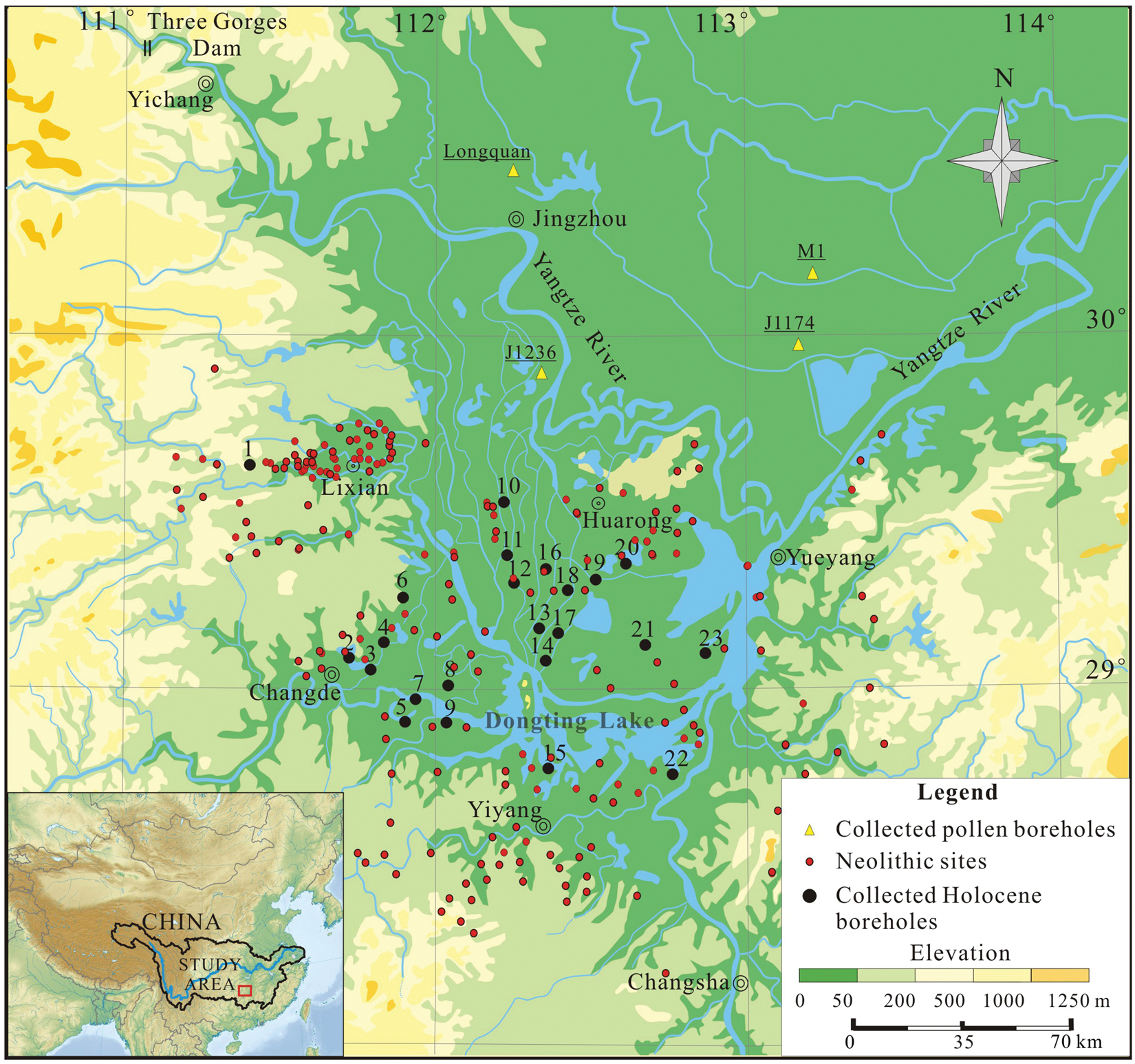
The mid Yangtze River basin showing the location of Neolithic sites and boreholes used in this paper. Inset: location map of the study area within China and the Yangtze basin
The lake has long been connected with the Yangtze main channel via four major inlets, though at present only three are operational (Figure 1). There is a single outlet at the downstream end of the lake, near Chenglingji, through which water returns to the Yangtze. The lake has its own drainage basin in south-central China. Dongting Lake has served as a natural reservoir for accommodating floods of the Yangtze (often >40 000–50 000 m3/s during the summer season) or providing extra flow to the mid-lower Yangtze basin during drier conditions (Changjiang Water Conservancy Commission, 2000).
The present Yangtze River is located between two large flood basins, the Jianghan Basin to the north and Dongting Basin to the south (Figure 1). Dongting Lake is situated in a floodplain of 18 000 km2 whose average elevation is 34 m above mean sea level (a.m.s.l.) and the plain is approximately 1–2 m higher than the mean lake water level. As a result of recent human interventions, such as dyking and damming, exchange of water between the channels in the network has been restricted. Dongting Lake at 33 m a.m.s.l., lies 1360 km from the coast and the riverbed gradient averages at 2.4 × 10⁻⁵. Dongting Lake and its floodplain are surrounded by mountains, ranging up to >1000 m in elevation (Huang, 1965).
Neolithic cultural stages
The Dongting Lake area has a long history of occupation during the Neolithic period. Five major cultural stages have been identified (Guo, 2005): Pengtoushan (9000–7900 cal. yr BP), Zaoshixiaceng (7900–6800 cal. yr BP), Daxi (6800–5500 cal. yr BP), Qujialing (5500–5000 cal. yr BP), and Shijiahe (5000–4000 cal. yr BP). The archaeological chronology of the cultural stages (cal. yr BP) has been established through examining pottery series and associated radiocarbon dating (Chen, 1994; Guo, 2005; Pei, 2004). The archaeological characteristics of these five cultural stages have been described by Pei (2006), Hunan Provincial Institute of Archaeology and Cultural Relics and International Research Center of Japanese Culture (2007) and Pei and Zhang (2009).
Methods and data base
For this study, information and data relating to 215 Neolithic sites and 178 dynastic (Shang-Zhou) sites in the Dongting Lake area (111°6.98′–113°32.61′E, 28°11.00′–29°57.55′N) were extracted from the research literature (Bureau of Chinese Cultural Relics, The, 1997). The Neolithic sites cover the five cultural stages but there appear to be few sites that have persisted through all five cultural stages (The Bureau of Chinese Cultural Relics, 1997). Some sites do contain several cultural stages. The Neolithic sites were further separated for the different cultural stages, totaling 243 for the present study. A worksheet of relevant information of the five Neolithic cultures for all sites was established and the sites were mapped for each cultural stage to show the trend of the migration pattern of Neolithic settlements in the Dongting Lake area throughout the Holocene.
In this study, a ‘lowest habitable base’ is proposed for each cultural stage, meaning the lowest level of habitation of sites on the lakeshore plain. This excludes those sites mounted artificially on the plain or hills. Using the modern habitable base and the present Dongting Lake water surface elevation as a guide, it is proposed that the lake water level is 1–2 m below the lowest habitable base in each cultural period. The number of sites available for reconstructing the lowest habitable base in each cultural stage is as follows: Pengtoushan (3), Zaoshixiaceng (4), Daxi (11), Qujialing (6) and Shijiahe (13). The burial depth (elevation) of a habitable base is the elevation of present ground surface at a site minus the total sediment thickness, including overlying cultural layers and soil. This has been used to reconstruct the lake water levels during Holocene and help define changes in the lake surface area through time.
Records of >200 boreholes drilled in the study area in recent decades, mostly for sedimentological and hydro-engineering surveys, were found in the literature (Cai et al., 1984; Lu 1991; Yang 1986; Zhang 1991), of which 23 boreholes were selected here on the basis of the useful data they provide for environmental reconstruction (Nos 1–23, Figure 1). The selection of the boreholes was based on: (1) availability of radiocarbon-dated sediment sequences, (2) identified Holocene subsections with regional comparability, (3) feasibility of sediment proxies, such as grain size and fauna/floral indicators, etc., and (4) proximity to the lake. Nine radiocarbon dates are available from these boreholes, all calibrated to the calendar year (cal. yr BP). In addition, the Holocene sediment thickness and stratigraphy of the Dongting Lake area is incorporated into the present data base (Lu, 1991; Yang, 1986). Details of these 23 cores and their locations are shown in Figure 2. In addition, a Holocene sediment isopach map of the Dongting Lake area is also available (Liang et al., 2001).
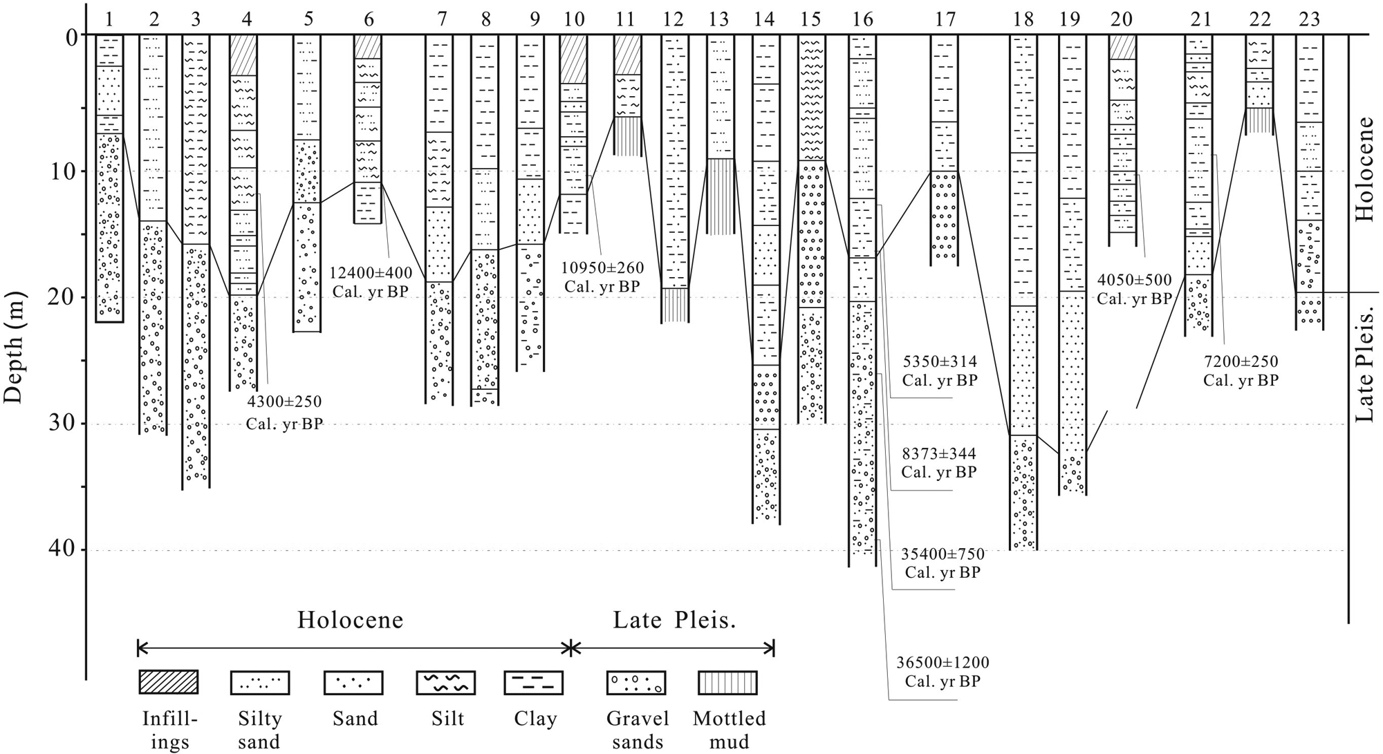
Twenty-three Holocene sediment boreholes collected from previously published studies. Also shown are the radiocarbon-dated sediment sections
Four Holocene pollen records are derived from boreholes J1236, J1147, M1 and Longquan, (Figure 1) located in the study area, and these contain 11 radiocarbon dates (Lu, 1991; Zhu et al., 1999). These dates were also calibrated to the calendar year (cal. yr BP). The age–depth profile was then converted for the pollen boreholes by means of interpolated average sedimentation rate between the radiocarbon-dated sediment sections. Ten (I–X) pollen-climate zones of the Holocene, together with inferred temperatures, discussed in this study were primarily derived from Lu (1991) on the basis of the dominant pollen species regionally representative in the three boreholes J1236, J1147 and Longquan. The number of the total sites and sites on the lake plain/coast separately were mapped for each of the climate periods identified.
Observation
The 23 sediment boreholes have demonstrated the distribution of Holocene sediment in the Dongting Lake area (Figure 2). The thickest Holocene sediment ranges from 20 m to 35 m (e.g. Nos 4, 7, 19), and thinner sediment is only 5–7 m. However, the isopach map shows the thickest Holocene sediment, ranging from 30 m to 50 m, which occurs along a paleo-river valley extending from the west to the northeast (Figure 3). Sediment 10–20 m thick occurs in the limited lake valley and extends northward to link with the Yangtze main stream. Most of the lake area is covered with sediment <10 m thick. Obviously, the former Holocene depocenter lies to the north of the present Dongting Lake (Figure 3).
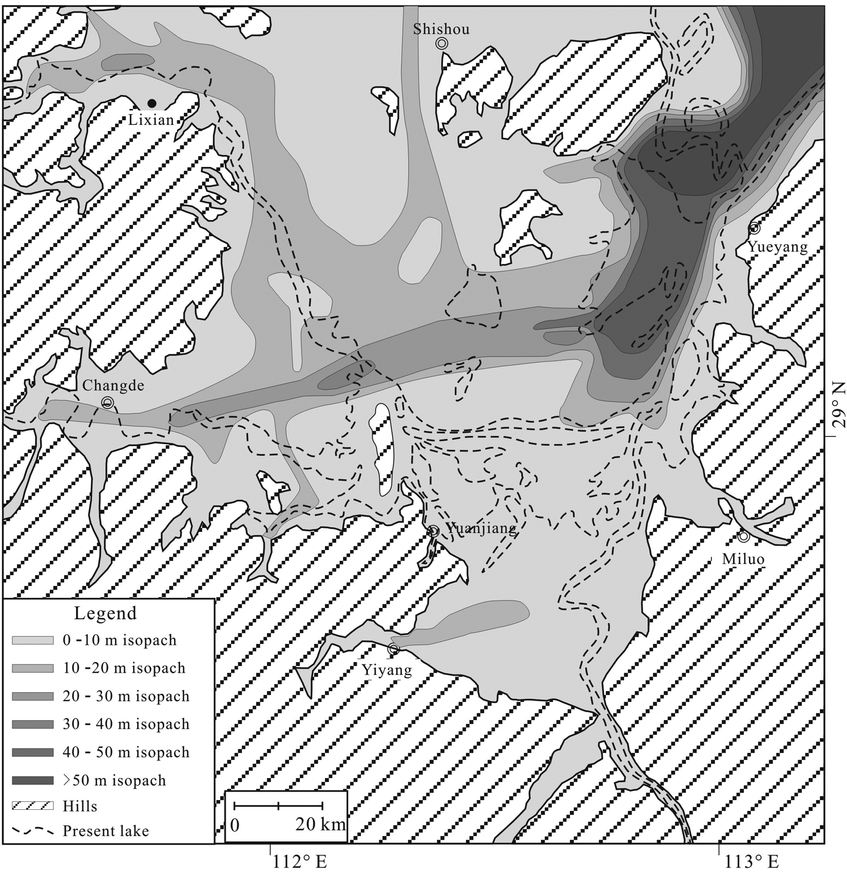
Isopach map showing the Holocene sediment thickness in the Dongting Lake area (data sources: Liang et al., 2001; Lu, 1991; Yang, 1986)
On the basis of the distribution of settlements and the calculated lowest habitable base, together with the sediment isopachs, five stages of the settlement-positioned lake-level fluctuations are identified in the study area, each denoting a close interlinkage between the settlement distribution and the lake coast. The data have revealed that during the Pengtoushan cultural stage (9000–7900 cal. yr BP), Neolithic sites were limited in number (12), mostly clustered in the northwestern tributary valleys and the lake plain adjoining the western hills. Only two appeared on the northern lake shore and one in the valley of an eastern tributary (Figure 4a). There are 14 sites identified in the Zaoshixiaceng cultural stage (7900–6800 cal. yr BP) with a cluster still in the western tributary valley and the plain adjoining the foothills as for the Pengtoushan stage. Sites increase in number on the northern and western lake shore and there is one site on the southern lake shore near a tributary river mouth (Figure 4b). The number of sites increases dramatically to 45 on the lake plain and the lake shore during the Daxi cultural stage (6800–5500 cal. yr BP). During this stage new sites appear for the first time on the plain south of the lake while the concentration of sites in the northwest persists. (Figure 4c). The number of sites identified for the Qujialing cultural stage (5500–5000 cal. yr BP) has decreased to 33 and particularly notable is the absence of sites south of the lake (Figure 4d). There are 139 sites located in the Shijiahe cultural stage (5000–4000 cal. yr BP) and these are widely spread in the lake area (Figure 4e). During the Shang-Zhou dynastic period (<4000–2700 cal. yr BP) numerous sites emerge in the lake area. Notably, there are fewer sites on the lake plain during this period and settlements are more concentrated on higher ground (Figure 4f).
The lowest habitable bases of the five Neolithic cultural stages denote the changes in lake elevation (Figure 4a–e). It seems that the habitable base remains higher (27.2 m) during the earliest Pengtoushan cultural stage, and then falls to 26.9–26.3 m in the subsequent Zaoshixiaceng and Daxi cultural stages. The base becomes highest during the Qujialing (27.6 m) and then falls to its lowest level (24.8 m) in the Shijiahe cultural stage. Of note, the change in elevation of the reconstructed lowest habitable base is coincidental with the spatial and temporal migration of Neolithic settlements of the five cultural stages (Figure 4a–e), reflecting rising and falling lake levels through Holocene.
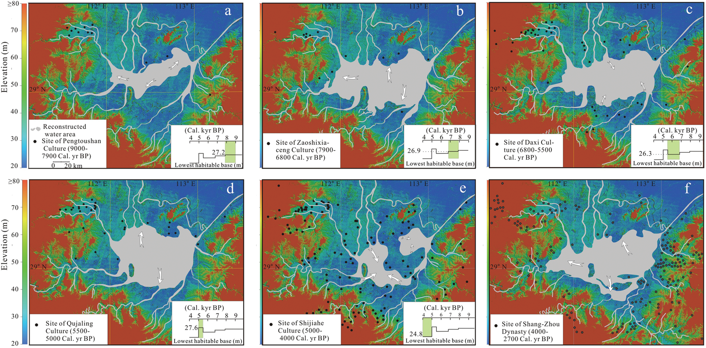
Spatial and temporal migration of Neolithic settlements and related lake level fluctuations: (a) Pengtoushan cultural stage (9000–7900 cal. yr BP), (b) Zaoshixiaceng cultural stage (7900–6800 cal. yr BP), (c) Daxi cultural stage (6800–5500 cal. yr BP), (d) Qujialing cultural stage (5500–5000 cal. yr BP), and (e) Shijiahe cultural stage (5000–4000 cal. yr BP). Settlement of the historical stage (Shang and Zhou dynasty, 4000–2700 cal. yr BP) is also shown as (f). The lowest habitable base, derived from those sites on the lake shore and floodplain is also shown. The Holocene sediment stratigraphy and sediment isopachs as used in reconstructing lake levels
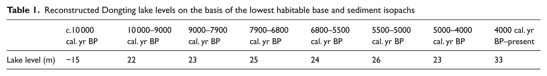
Using the Holocene sediment boreholes and isopach map together with the established habitable bases, it is estimated that the lake level at c. 10 000 yr BP stood at c. 15 m below a.m.s.l. and then the lake level has risen to c. 22 m (a.m.s.l.) at 9000 yr BP. The lake level fluctuated between 23 m and 26 m (a.m.s.l.) during Neolithic cultural stages, and then continued to rise to 33 m (a.m.s.l.) at present (Table 1).
Reconstructed Dongting lake levels on the basis of the lowest habitable base and sediment isopachs
On the basis of observation by Lu (1991) and Zhu et al. (1999), the Holocene pollen spectra of the study area indicate ten climate zones (I–X; Figure 5). Pollen assemblage of each zone can be summarized as: Zone I, Pinus – Betula – Artemisia; Zone II, Quercus – Pinus – Castanea – Artemisia; Zone III, Pinus – Quercus – Betula – Artemisia – Polypodiaceae; Zone IV, Quercus – Pinus – Castnea – Artemisia – Polypodiaceae; Zone V, Pinus – Quercus – Betula – Artemisia – Gramineae – Polypodiacea; Zone VI, Quercus – Pinus – Carpinus – Gramineae – Artemisa – Polypodiaceae; Zone VII, Pinus – Quercus – Ulmus – Artemisia – Polypodiaceae; Zone VIII, Quercus – Cyclobalanopsis – Castanea – Gramineae – Artemisia; Zone IX, Artemisia – Polypodiaceae – Pinus – Quercus; and Zone X, Quercus – Pinus – Polypodiaceae. These pollen zones have been interpreted as being related to Holocene climate temperature fluctuations (Figure 5), in terms of the four periods of warmer/wetter conditions separated by shorter periods of drier/cooler conditions (Figure 5).
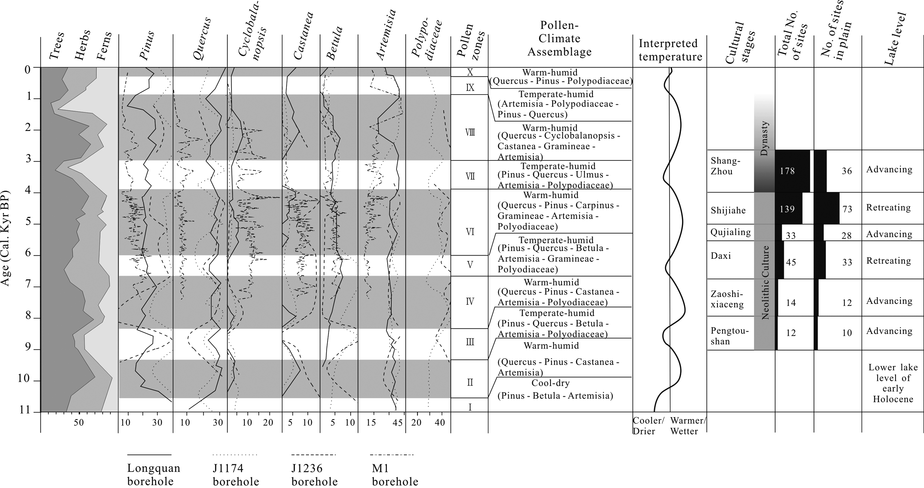
Comprehensively interpreted Holocene pollen zones (I–X), and associated climate trends, cultural stages and lake level fluctuations in the middle Yangtze basin (data sources: Bureau of Chinese Cultural Relics, The, 1997; Lu, 1991; Zhu et al., 1999)
Discussion
Neolithic civilizations in the middle Yangtze River basin, primarily associated with rice cultivation, can be traced back to c. 10 000 yr BP (Guo, 2005; Pei, 2004; Xiang, 1998). The vast fertile floodplain of the lake area, nourished by sediment from the Yangtze and watered by the summer monsoon rains, supported this early development of human societies (Jiang and Piperno, 1999; Pei, 2006; Pei and Zhang, 2009). It has been considered as one of the two major river basins, along with the Yellow River basin, where the earliest Chinese civilizations were established (Yan, 2008; Zhou and Gong, 1991).
The isopach map and sediment boreholes show that the Dongting Lake area was an incised valley in the early Holocene some 20 to 50 m below the present ground surface and the bed of the present lake (Figure 2). The depocenter of the lake has shifted southward, probably indicating a southward trend of lake basin siltation due to the concentration of sediment into Dongting Lake from the Yangtze mainstream since the mid Holocene (Liang et al., 2001). Many earlier studies have reported a southward shift of the depocenter as a result of tectonic tilting that has caused the middle Yangtze mainstream to migrate southward (Huang, 1965; Liang et al., 2001; Pi et al., 2001) (Figure 1). This also corresponds with the shrinking of Dongting Lake from >6000 m2 to c. 2500 m2at present, notably through the southward migration of the northern shore of the lake.
Presumably the incised and elongated lake valley with limited water surface area in the early Holocene confined early agriculture and associated human occupation to higher land and hillsides less conducive to the cultivation of paddy rice (Figure 3). The limited number of settlements of the Pengtoushan cultural stage (9000–7900 yr BP) in the upstream area north of the lake probably corroborates this observation (Figure 4a). Limited, but more northerly scattered settlements of the Zaoshixiaceng cultural stage (7900–6800 yr BP) indicate a further lake-level rise. The wider coverage of Holocene sediment of 10–20 m thick supports this observation (Figure 3). The valley occupied by the lake became wider and flatter in topography, enabling wider coverage by a small rise in lake level.
The habitable base in the Pengdoushan cultural stage was not so sensitive to lake level fluctuation. The reconstructed lowest habitable base of 27.7 m may not be closely associated with lake level, because of a lower population with less intensive agricultural activities in the early Holocene. Settlements at that time period were located on the widely available hill slopes rather than the limited lake shore sites (Pei, 2004). Although the lowest habitable base of the subsequent Zaoshixiaceng cultural stage fell to 26.9 m, the lake area appears to have expanded in that time, presumably by a rise in lake water level (Figure 4a,b).
Many newly emerged settlements of the Daxi cultural stage (6800–5500 cal. yr BP) on both the north and south Dongting Lake shore and floodplain clearly indicate lowering lake level relative to the previous stage. Accordingly, the lowest habitable base fell to 26.3 m a.m.s.l. (Figure 4c). It seems that delta and coastal progradation developed quickly on the north and south lake shores in the mid Holocene. A 10 m thickness of sediment expends across the lake area (Figures 2, 3).
The disappearance of settlements in the following Qujialing cultural stage (5500–5000 cal. yr BP) probably reflects the expansion of the lake area. Settlements on the south shore and floodplain mainly vanished while some persisted on the north shore. Corresponding to this, the lowest habitable base rose to 27.6 m a.m.s.l., suggesting lake shore advance during this short time period in the mid Holocene (Figure 4d). Immediately following this stage a swarm of settlements appeared in the Shijiahe cultural stage (5000–4000 cal. yr BP), spread across the lake region (Figure 4e). The lowest habitable base of this time period fell to 24.8 m a.m.s.l., indicating contraction of the lake. The lake expanded again into historical time, as illustrated by the settlement distribution of the Shang-Zhou dynastic time period (4000–2700 cal. yr BP; Figure 4f).
The pollen spectra of Dongting Lake indicate the shifts of climate through the Holocene, and ten pollen-climate zones (I–X, from old to young; Figure 5) have been identified (Lu, 1991). This primarily reflects the mid-Holocene climate warming trend and climate optimum, which was suitable for human occupation (Chen et al., 2005; Shi et al., 1993). Climate fluctuations in the Holocene, as interpreted from the pollen spectra, consist of alternating periods of warm-humid and temperate-humid climate across the mid Yangtze River basin. Lu (1991) argued that the temperature in the mid Holocene could have reached 2–3°C higher than the present. Of note, the overall warming trend observed in this area corresponds with that observed more widely across eastern China (Yang and Xie, 1984).
The climate fluctuations generally correspond to rise and fall of lake level with a tendency for the lake to expand with the onset of warmer and wetter conditions and contract under cooler and drier conditions (Figures 4, 5). The total number of Neolithic settlements (both hill sites and plain sites) increase from early to late Neolithic cultural stages along with the overall trend of climate warming, but those located on the lake shore and floodplain coincide fairly well with the rise and fall of the lake level (Figure 4). Also, it appears that the lake level rise accelerated from the early to mid Holocene as indicated by the lowest habitable base data (Table 1). This can be interpreted in terms of the limits on the capacity of the lake to store water, from the incised lake valley in the early Holocene to the broader lake valley with lower gradient in the mid and late Holocene, as the lake has been gradually filled up with sediment from the Yangtze mainstream (Figures 2 and 3).
Variations in the monsoon climate have influenced the lake levels that offered selectivity for the early human occupation in the Dongting Lake basin area, together with rice cultivation, but societal advancement, including migration of settlement and livelihood pattern, had to adapt to climate-related lake level change (He, 1997; Pei, 2006). Previous research in this area indicates that rice cultivation began as early as 10 000 years ago, probably the earliest rice cultivation in the world (He, 1997; Zhang and Yuan, 1998). The rise in lake level and associated Yangtze sediment deposition has nourished the Dongting basin, and the warming climate since the early Holocene has stimulated the development of agriculture. From Figures 4 and 5, it can be seen that the emergence of the Pengtoushan culture (9000–7900 cal. yr BP), the earliest human society in the mid Yangtze River basin, occurred when the climate warmed and became more humid in the early Holocene.
Of great interest is the observation that the majority of Neolithic settlements in the study area persisted across just one cultural stage (Figure 4) (The Bureau of Chinese Cultural Relics, 1997). This obviously differs from what was observed on the lower Yangtze River delta coast, where numerous Neolithic settlements had been relatively permanently located for several thousands of years (~7000–5000 yr BP; Chen et al., 2008) before limnolization due to sea invasion (see Zong et al., forthcoming). It is thus reasonable to propose that in addition to adaptation to climate change, settlement relocation, together with social sophistication, would have to meet the rapid environmental changes occurring in the region (see examples in the lower Yangtze basin in Atahan et al., 2008; Qin et al., 2011). For instance, the vast newly emerged delta system on the southern lake coast during the Daxi cultural stage (8600–5500 yr BP; Figure 4c) would have attracted the Neolithic community there, and the later Shijiahe settlement occupation could be associated with coastal reclamation because of increasing population (Figure 4e).
Although the climate has fluctuated throughout the Holocene in the middle Yangtze River basin between warm-humid and temperate-humid (Figure 5), these shifts have never been sufficiently large to inhibit the development of rice cultivation. This greatly contrasts with the Nile River basin, where changing climate from pluvial to arid from early to mid–late Holocene dramatically altered the pattern of human settlement, i.e. from agriculture to a grazing and hunting society (Nicoll, 2004).
Conclusion
Our sedimentological data base has shown that Dongting Lake in the mid Yangtze River basin began as an incised and elongated valley in the early Holocene. The lake valley was then filled in with Yangtze River sediment as the river shifted southward in response to regional tectonic tilting. The lake became broader and shallower, facilitating the spread of early human habitation.
Five major Neolithic cultural stages occurred in the lake region; the Pengtoushan (9000–7900 cal. yr BP); Zaoshixiaceng (7900–6800 cal. yr BP); Daxi (6800–5500 cal. yr BP); Qujialing (5500–5000 cal. yr BP); and Shijiahe (5000–4000 cal. yr BP). The Neolithic settlements first appear clustered in the northwest of the lake region, and then are evident on the northern lake shore and floodplain. Many settlements appeared on the southern lake shore and floodplain in the mid Holocene, but disappeared within a short time (c. 500 years), before a significant increase in settlement numbers 5000–4000 years ago.
The Holocene pollen-spectra of the Dongting Lake area denote an overall warming trend in climate, characterized by four cycles of temperature and moisture fluctuations. A monsoon climate fluctuating between warm-humid and temperate-humid conditions in the Holocene has provided a favourable physical setting for human adaptation as represented by the basin-wide spatial and temporal migration of Neolithic settlements in response to the waxing and waning of the lake level.
Footnotes
Acknowledgements
We are sincerely grateful to Dr Guo Weimin and Mr Feng Jianping for their kind assistance with fieldwork, and for providing constructive comments. The ECNU Fostering (Grant no. PY2011008), the Ministry of Science and Technology, China (Grant no. 2010RCDW02), The Creative Research Groups of the China Natural Science Foundation (40721004), and The Ministry of Education of China-111 Project supported this study.