
Abstract
Holocene glacier activity in the northern British Columbia Coast Mountains, Canada, is described following investigations in the recently deglaciated forefields of White and South Flat glaciers spilling from the Cambria Icefield. Glacially overridden stumps and detrital wood was radiocarbon and dendrochronologically dated to describe an advance between
Introduction
The rapid retreat and downwasting of glaciers in the Pacific Northwest (PNW) of North America over the last few decades has exposed land surfaces and glacially killed tree remains that provide insights into periods of glacier activity during the Holocene epoch. These discoveries provide rich evidence of glacial activity and highlight a complex story of glacial advance and retreat. These findings serve to increase our understanding of glacier expansion within the Neoglacial period in this region (Clague and Matthews, 1992; Denton and Stuiver, 1966; Ryder and Thomson, 1986).
Evidence for Holocene glacier activity is widespread in the British Columbia (B.C.) Coast Mountains. Recent investigations show that glaciers in this region repeatedly advanced and retreated over the Holocene (Calkin et al., 2001; Menounos et al., 2009; Wiles et al., 2008). Eight periods of expansion are recognized: at c. 8000 14C yr BP (Menounos et al., 2009); between 6000 and 5000 14C yr BP (Ryder and Thomson, 1986); at 4900 14C yr BP (Menounos et al., 2009); at c. 4200 14C yr BP (Osborn et al., 2007); at c. 3000 14C yr BP (Ryder and Thomson, 1986); at c. 2300 14C yr BP (Smith and Koehler, 2011); at c. 1700 to 1500 14C yr BP during the First Millennium Advance (FMA: Reyes et al., 2006); and, during the ‘Little Ice Age’ (LIA) from c. 900 to 100 yr BP (Larocque and Smith, 2003). Despite this growing body of evidence, there remain regions in the Coast Mountains where little or no research has been completed (Menounos et al., 2009).
This paper describes the late-Holocene history of two glaciers flowing from the relatively unstudied Cambria Icefield (Figure 1). Reconnaissance investigations in July 2008 led to the discovery of fresh exposures of subfossil wood buried in and below glacial sedimentary units. Additional sites and detrital subfossil wood deposits were discovered in July 2009. Dendroglaciological research methodologies were applied to describe the ice front behavior of these two glaciers and to consider the climatological context of their Holocene behavior.
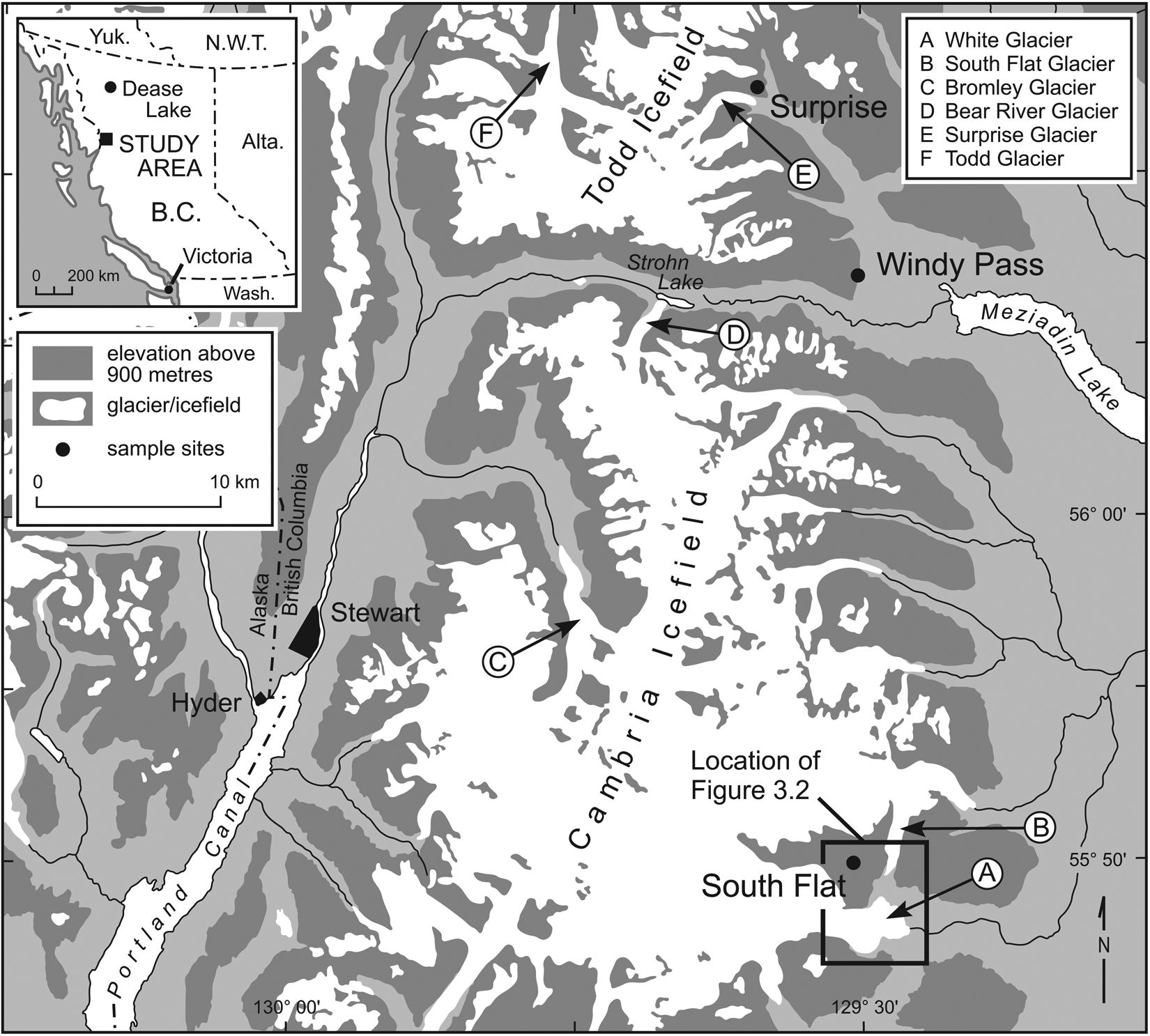
Location of White Glacier (A) and South Flat Glacier (B) in the Cambria Icefield, B.C.
Study site
White and South Flat glaciers are outlet glaciers along the eastern Cambria Icefield situated 35 km southeast of Stewart, B.C. (Lat 55°47′N, Long 129°29′W; Figure 1). Located within the Boundary Ranges, the icefield covers 715 km2 and includes within its boundaries the summit of Treble Mountain at 1830 m a.s.l. A number of large outlet glaciers spill into surrounding valleys to present-day terminus positions at 885 to 510 m a.s.l. High-elevation montane forests surrounding the icefield are characterized by mixed stands of mountain hemlock (Tsuga mertensiana [Bong.] Carr.) and subalpine fir (Abies lasiocarpa [Hook.] Nutt.; Meidinger and Pojar, 1991). The upper treeline is found at around 1500 m a.s.l.
Within the last century the outlet glaciers within the Cambria Icefield area have down-wasted and receded between 2.5 and 6 km upvalley from LIA terminal positions at 815 to 380 m a.s.l. McConnell (1913) recorded 50 m of retreat at the north-facing Bromley Glacier from 1910 to 1911; Field (1975) notes that the glacier continued to retreat 30 m/yr up valley from 1911 to 1946. Matthews (1965) reports on the retreat of Bear River Glacier in the 1940s and 1950s and the impoundment of ice-proximal Strohn Lake. In the adjacent Todd Icefield area, Jackson et al. (2008) recorded terminus retreat rates at five glaciers from 1974 to 1997 at rates varying from 9 to 76 m/yr.
White Glacier
White Glacier (Lat 55°51′N, Long 129°31′W; Figure 2) flows eastward from the Cambria Icefield and in 2009 terminated at 820 m a.s.l. adjacent to South Flat River, a tributary to White River. The recently deglaciated terrain in front of White Glacier is characterized in the north forefield area by massive unconsolidated sedimentary deposits eroded by abandoned stream channels and in the southern forefield area by exposed bedrock outcrops.
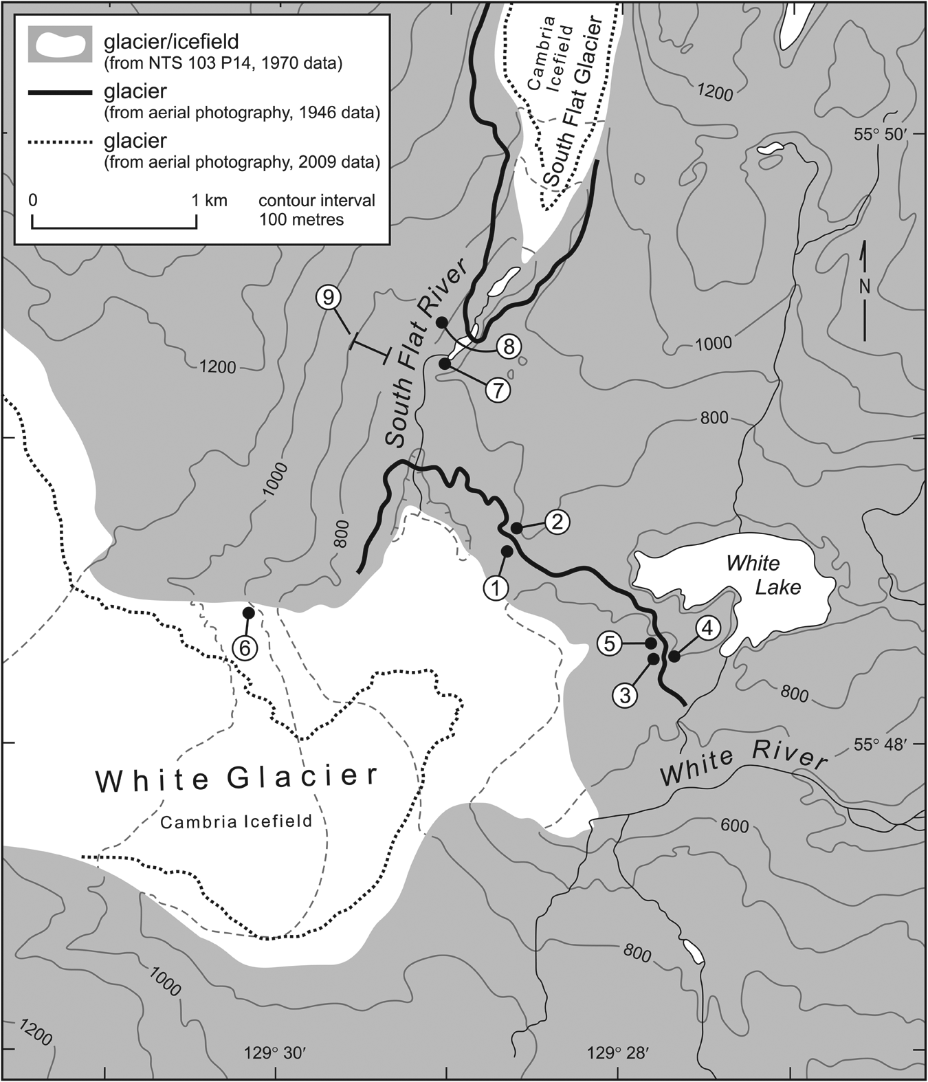
Site map of White and South Flat glaciers and study sites from 1946 aerial photo data.
The LIA extent of White Glacier is demarcated by a terminal moraine 2.5 km from the 2008 glacier terminus at 715 m a.s.l. The moraine dams White Lake and is colonized by Sitka alder (Alnus sinuata [Regel] Rydb.). As the glacier advanced, retreated, and periodically blocked meltwater flowing down-valley from South Flat Glacier to the north, it is likely that a glacially dammed lake formed adjacent to White Glacier and drained a number of times. Aerial photographs from 1946 (A12276) show grounded icebergs north of White Glacier. During geological investigations in the early 1960s, Grove (1973) described a glacially dammed lake close to the confluence of White and South Flat glaciers. Field investigations in 2008 found evidence suggesting the very recent draining of a glacially dammed lake
South Flat Glacier
South Flat Glacier (Lat 55°51′N, Long 129°27′W; Figure 2) is a distributary of the larger Flat Glacier (unofficial name) that flows from the Cambria Icefield to drain into South Flat River. South Flat Glacier spills over the hydrological divide south into South Flat valley. Downvalley of the 2008 glacier terminus, the valley is characterized by prominent bedrock outcrops and extensive bedded sedimentary units. Cross-sections in abandoned outwash channels show the latter unit consists of >10 m thick silt-dominated glaciolacustrine deposits, with interbedded units of steeply dipping sand and gravel delta deposits. The sedimentary units terminate down-valley adjacent to an interlobate moraine marking the confluent late-LIA extent of White and South Flat glaciers.
Research methods
Tree-ring records were collected from living trees and subfossil wood remains exposed at nine sites (Figure 2). Increment core samples were collected from a stand of living mountain hemlock trees positioned west of the 2008 terminus of South Flat Glacier. A chainsaw was used to collect cross-sectional samples from subfossil stumps and detrital wood. After air drying and mounting the samples were sanded to a fine polish at the University of Victoria Tree-Ring Laboratory. The samples were scanned and the total ring-widths measured to the nearest 0.01 mm using WinDENDRO™ software. For samples with narrow annual rings, the ring-widths were measured to the nearest 0.01 mm with MeasureJ2X (VoorTech Consulting 2009) using a Velmex-stage equipped with a microscope and CCD video display.
The living tree-ring samples were internally cross-dated using CDendro software (Ver. 7.1, Cybis Elektronic & Data AB). Following this the International Tree Ring Database (ITRDB) software program COFECHA was used to verify the cross-dating using block correlations between each tree-ring series and the master chronology (Holmes et al., 1986). COFECHA correlations were calculated using a 50-year segment length lagged successively by 25 years at a one-tailed 99% confidence level (Grissino-Mayer, 2001). A living tree-ring chronology was constructed using double detrending options (negative exponential option 2 and cubic smoothing spline option 4) in the ITRDB software program ARSTAN (Cook and Holmes, 1986) to retain low-frequency variability within the resulting chronology (Cook et al., 1990). To create a single dimensionless value for each growth year, each ring-width index series was prewhitened using autoregressive and moving average models to remove autocorrelation effects (Biondi and Swetnam, 1987; Cook, 1985).
The species of subfossil wood samples was identified using a 40× microscope and a standard reference key (Hoadley, 1990). Site-specific floating tree-ring chronologies were constructed from the subfossil samples following established cross-dating protocols (Stokes and Smiley, 1968) and CDendro software. An attempt was first made to determine the absolute age of each floating chronology by cross-dating to the standardized living chronology. Where this failed, calibrated ages determined from perimeter wood samples submitted to Beta Analytic Inc. for standard radiocarbon dating were assigned to the floating chronologies (Luckman, 1995; Smith and Lewis, 2007). A calendar age is represented by taking the midpoint of the calibrated age range dates, except in the case of multiple age intercepts where all possible ages are reported (Koehler and Smith, 2011).
Observations
Tree-ring chronology
Twenty-seven ring-width series from 17 trees were used to construct a living tree-ring chronology spanning 373 years (
Dendroglaciological samples
Glacially sheared stumps and woody debris were found at six locations proximal to White Glacier and three sites downstream of South Flat Glacier (Figure 2).
Site 1 was located c. 750 m from the 2007 terminus of White Glacier within a 25 m high abandoned channel cutbank at 653 m a.s.l. (Figure 2). Distinguished by three stratigraphic units, the lower unit (Unit 1A; Figure 3) consists of a massive 10 m thick matrix-supported till with an upper surface truncated by a laterally extensive wood mat. The mat extends for c. 15 m and contains glacially transported bole, branch and stump fragments inter-mixed with till. The wood mat is overlain by a weakly bedded 7 m thick till unit (Unit 1B; Figure 3) capped by an oxidized sedimentary horizon dipping up-slope 20° west–east. At this juncture a thin composite horizon consisting of small detrital wood pieces and gravels extends across the cut face. Resting on the surface of this horizon is a 7 m thick till unit (Unit 1C; Figure 3) whose upper surface features small-scale northwest-trending flutes. Cross-sections from boles found at the boundary between Units 1A and 1B indicate the trees were from 126 to 160 years old when killed. An age of
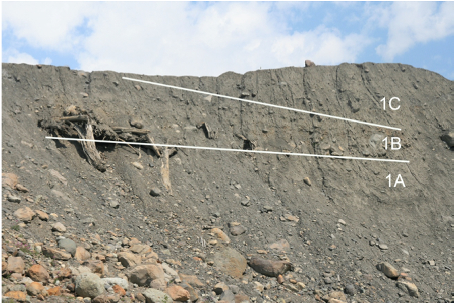
Looking north towards site 1. Three units are highlighted: A 10 m thick matrix-supported till (1A), wood samples collected from the wood mat (WG01_01) on the surface of 1A date to ad 605. This unit is overlain by a 7 m thick till unit (1B) capped by an orange-stained sedimentary horizon. Resting on the surface of this horizon is a 7 m thick till unit (1C) whose upper surface features small northwest-trending glacial flutes.
Summary of conventional age radiocarbon dated samples from White and South Flat glaciers. A calander age is represented by taking the midpoint of the calibrate age range dates (from Koehler and Smith, 2011).

saf: subalpine fir; mh: mountain hemlock. Species were identified by their gross anatomical characteristics (Hoadley, 1990).
All radiocarbon dates and 2σ ranges calculated by Beta Analytic Inc. using INCAL04.
The floating tree-ring chronologies created and their conventional age dates assigned after unsuccessful cross-dating into the living tree-ring chronology. If the sample was used in the FMA Chronology then the perimeter age date is recorded.
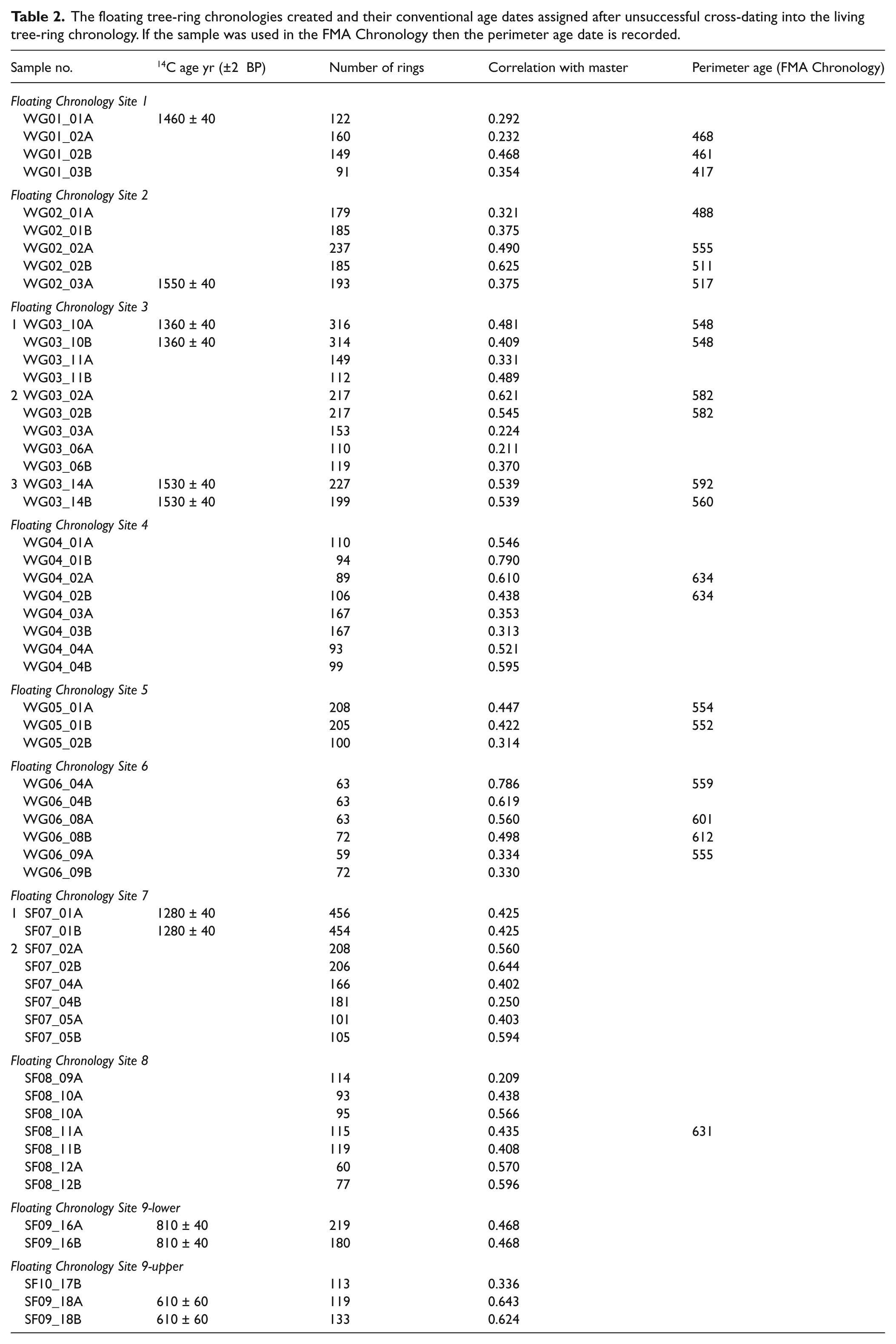
Site 2 is located 25 m upstream from Site 1 at 673 m a.s.l. (Figure 2). Exposed in a vertical cutbank is a 20 m thick section of till containing 2–3 m long boles with masticated surfaces. Cross-sections were collected from four boles positioned 12 and 17 m above the abandoned channel floor. The samples contain from 185 to 237 annual rings, and three cross-date to form a 250 year long floating mountain hemlock chronology (Chronology 2, Table 2). Radiocarbon dating of perimeter rings from WG02_03 indicate the chronology extends from c.
Site 3 is positioned below the proximal face of a prominent 10 m high glacially eroded bedrock outcrop at 679 m a.s.l. (Figure 2). The colluvial footslope consists of diamicton intermixed with partially buried broken and fragmented bole segments up to 6 m in length. Cross-sections from 15 samples led to the construction of two chronologies. A subalpine fir chronology (Chronology 3-1, Table 2) extending over a 316 yr interval is anchored by perimeter wood dating to
Site 4 is located 25 m west of Site 3 at 675 m a.s.l. on the east face of a prominent bedrock outcrop. The site was ice-free prior to 1946 and contains 0.5–1 m long bole segments (99 to 110 rings) pressed into a small pocket of organics. Three subalpine fir samples cross-date to form a floating 110 yr long chronology (Chronology 4, Table 2) that cross-dates to Chronology 3-3 at Site 3 (Table 2), indicating that they were killed c.
Site 5 is located c. 20 m north of sites 3 and 4, in an 6 m deep east–west facing bedrock gully at 660 m a.s.l. A large accumulation of broken and fragmented detrital wood appears to have been pushed into the gully as White Glacier advanced over the surrounding bedrock surface. Although most of the wood at Site 5 was rotted and in poor condition, cross-sections from two boles (WG05_01 and WG05_02; Table 2) cross-date to form a 205 yr long chronology killed in c.
Site 6 is found north of White Glacier at 1002 m a.s.l. on the west side of a prominent bedrock ridge separating the White and South Flat glacier forefields, where a pocket of till was lodged into a bedrock gully. Cross-sections retrieved from five partially buried 2–7 m long boles (63–72 rings) cross-date to form an 81 year long floating chronology killed c.
Site 7 is located 2 km downstream from the 2007 terminus of South Flat Glacier at 762 m a.s.l. where meltwater incised through over 70 m of till and glaciolacustrine sediment. A sheared stump with 456 annual rings (WG07_01; Table 1) in growth position exposed along the channel bank of South Flat River was killed c.
Site 8 is found 900 m from the 2007 terminus of South Flat Glacier at 820 m a.s.l. Adjacent to a prominent bedrock gorge is a 25 m thick exposure of steeply dipping laminated sands and gravels capped by till. The latter extends upwards to a non-conformable contact with fine-grained horizontally bedded rhythmites. Numerous woody fragments and bole segments were exposed within the upper section of the lower laminated unit. Cross-sections collected from five small logs cross-date (59-117 rings; Table 2) and sample WG08_11 indicates all the trees died c.
Site 9 refers to a 60 m high vertical cross-section located c. 50 m above Site 7 consisting of a horizontally bedded laminates with alternating units of gravel and silty-sands. Woody horizons at several levels appear matched by equivalent units visible on the other the side of the valley. Cross-sections from detrital wood collected at 840 m a.s.l. (130–219 rings; Chronology 9 lower, Table 2) indicates the trees were killed in
Results
Twelve site- and species-specific floating chronologies were created from subfossil wood found at recently exposed sites in the White and South Flat glacier forefields (Table 2). Cross-dating to the regional mountain hemlock and an archived subalpine fir chronology (Jackson et al., 2008) was unsuccessful, indicating that the subfossil samples were killed prior to
Seven floating chronologies cross-date to one another and were combined to form the ‘Cambria’ chronology (Table 2; Figure 4). The chronology spans a 393 year interval and includes numerous radiocarbon-dated samples (Tables 1 and 2) indicating the trees were killed at various times between
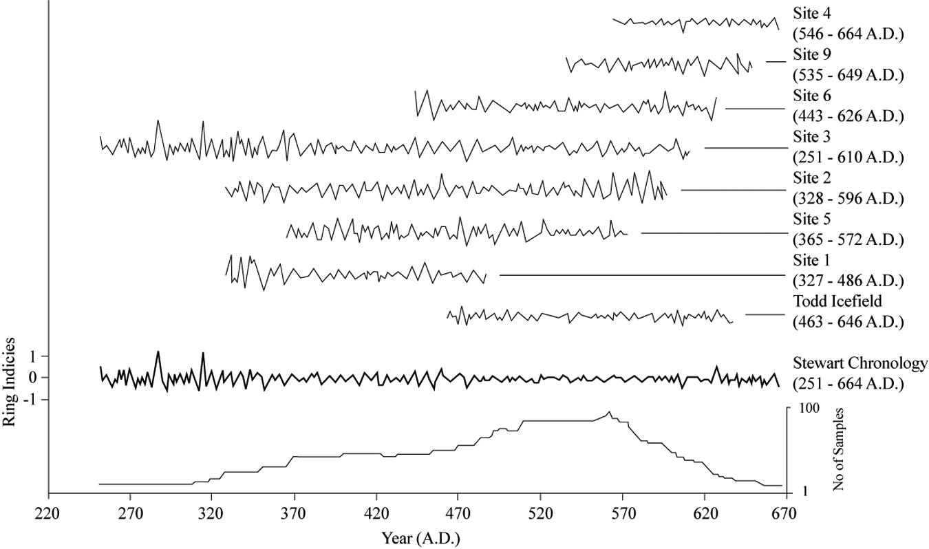
First Millennial Advance chronology anchored by conventional radiocarbon date from WG03_10 (Table 1). The chronology consists of samples from White and South Flat glaciers, as well as previously collected samples from the Todd Icefield area (from Jackson et al., 2008). The chronology extends from
The floating ‘Cambria’ chronology was subsequently cross-dated with 15 floating subfossil samples previously collected in the nearby Todd Icefield area (Jackson et al., 2008). The resulting ‘Stewart’ chronology contains 38 tree-ring records, spans a 393 year period, and includes six radiocarbon-dated perimeter wood samples (Table 1). Perimeter wood from WG03_10 records the most recently killed sample (
Interpretation
Field investigations were used to document an FMA advance of White Glacier from c.
Evidence from the White Glacier forefield (sites 1–6) describes an FMA ice front advance from
Following this the snout of White Glacier continued to thicken and extend up the valley site, reaching Site 3 by c.
The distal position of the woody detritus at Site 4 indicates that White Glacier advanced over the ridge crest and was flowing downslope toward White Lake after
FMA expansion and thickening of White Glacier eventually resulted in an ice dam that blocked the drainage of meltwater flowing from South Flat Glacier down South Flat valley (Figure 5). The timing and nature this ice dam is constrained by the in-situ stump located at Site 7 (WG07_01; Table 1). Killed when submerged by proglacial lake water in
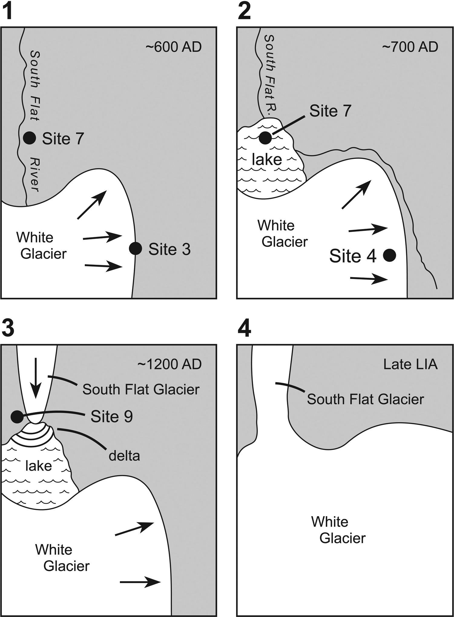
Schematic of the expansion of White Glacier and the subsequent interaction of White Glacier with South Flat Glacier between c.
Abandoned bedrock channels at c. 800 m a.s.l. indicate that water from the lake spilled over the intervening ridge to White Lake at a late high-elevation stage (Figure 5). The existence of an ice-dammed lake in
The initiation of LIA glacier activity at White and South Flat glaciers is recorded by detrital wood found within the thick unit of glaciolacustrine deposits that unconformably overlie FMA-aged sediments at Site 9. The large bole segments recovered within alternating sand and gravel units at the base of the unit (840 m a.s.l.) are interpreted to record a proglacial subaerial setting (WG08_12; Table 1). Overlying this deposit is a thick unit of coarsely laminated sand facies that records sedimentation in a shallow ice- or moraine-dammed lake associated with the extension of White Glacier into South Flat valley. Broken bole fragments dating to
Discussion and synthesis
Although previous research in the region indicates the FMA is distinguished by an early (
Thick bottomset and delta foreset sedimentary units describe an interval of sustained infilling of the lake that persisted until after
The reconstructed FMA and LIA glacial history of White and South Flat glaciers is comparable with that reported at other sites in the region (Reyes et al., 2006). Clague and Matthews (1992) note that Frank Mackie Glacier was in an advanced state from
The early-LIA activity of South Flat and White glaciers appears contemporaneous with activity documented at nearby Beare River (
The apparent regional synchronicity of these FMA and early-LIA advances prompted an examination of ring-width variability within the two climate-sensitive tree-ring chronologies constructed as part of this study. To highlight temporal rhythms retained within the subfossil and living chronologies, an interactive wavelet analysis (http://paos.colorado.edu/research/wavelets; Torrence and Compo, 1998) with a Gaussian 2 function and a 10% white noise reduction was completed.
As shown in Figure 6, both chronologies retain a repetitive 8 year event thought to be associated with climate forcing mechanisms described by the El Niño Southern Oscillation (ENSO). This mode of variability persists throughout the duration of the live chronology (Figure 6a), but appears to weaken in the Stewart chronology as FMA glacier expansion began prior to

The wavelet power spectrum for the (a) Live Chronology, and (b) the Stewart Chronology. The contour levels are chosen so that 75%, 50%, 25%, and 5% of the wavelet power is above each level, respectively. The cross-hatched region is the cone of influence, where zero padding has reduced the variance. The black contours demark the 15% significance level, using a white-noise background spectrum (Torrence and Compo, 1998).
Within shorter timescales, the year-to-year radial growth of trees in this region positively correlated to mean summer (June–July–August) air temperature. These temporal signals retained within the living and subfossil chronologies indicate that climate forcing events originating over the Pacific Ocean have persistently influenced the radial growth of trees in this region. As glacier mass balance changes in this region are principally influenced by climate variables (Larocque and Smith, 2005), the correspondence of shifts in the character of these relationships prior to the FMA and early-LIA advances documented in this study hint at the role that La Niña events may have played in generating positive glacier mass balance states and glacier advances over the last two millennium (c.f. Villalba et al., 2001; Watson et al., 2006). Documentation of enhanced PDO activity after
Proxy evidence of this relationship comes from western hemlock (Tsuga heterophylla [Raf.] Sarg.) pollen deposited in Pyramid Lake in the Cassiar Mountains of B.C. (Spooner et al., 2003). Increases in the influx of coastal pollen types beginning c. 1500 yr BP is interpreted to be a consequence of changes in regional air-mass circulation patterns that brought cooler and wetter weather to PNW (Overland et al., 1999). If this interpretation is correct, the FMA advances recorded throughout PNW at this time may be associated with persistence of deeper Aleutian Low pressure systems (Trenberth, 1990).
Summary
Glaciers flowing from the Cambria Icefield in northwestern B.C. have receded and down-wasted significantly in the last 60 years. Investigations completed in the recently deglaciated forefields of White and South Flat glaciers led to the discovery of two late-Holocene intervals of glacier expansion. Dendroglaciological evidence from the White Glacier forefield describes an FMA ice-front advance from
The late-Holocene glacial history of White and South Flat glaciers appears synchronous with those of the other glaciers in northern portion of PNW. An assessment of living and subfossil tree-ring records from the Cambria Icefield area was used to infer the climate forcing mechanisms that resulted in the documented FMA and early-LIA advances. Persistent temporal relationships to the ENSO and PDO climate indices are reflective of the strong maritime influence that the Pacific Ocean has on glacier mass balance regimes in the region. Whereas decadal–interdecadal shifts in these relationships result in ice front fluctuations, it seems likely that sustained events like the FMA arose following pronounced reconfigurations of regional air-mass circulation patterns.
Footnotes
Acknowledgements
We extend our thanks to the UVTRL for field assistance in 2008 and 2009. We thank two anonymous reviewers for their helpful comments and suggestions to earlier drafts of our paper.
Funding
D Smith received project support through a grant from the Natural Sciences and Engineering Research Council of Canada (NSERC) and from an award made by the Canadian Foundation for Climate and Atmospheric Sciences (CFCAS) to the Western Canadian Cryospheric Network.