
Abstract
Based on Optically Stimulated Luminescence (OSL) and radiocarbon dating we establish chronologies of colluviation and alluviation in different floodplain sections of the northwestern Wetterau loess basin (Germany). Similar to some other European valley floors, Holocene floodplain aggradation is marked by two important breaks: (1) a millennial-scale delay between the Neolithic agricultural colluviation and floodplain aggradation. In loess catchments agricultural colluviation started at about 7000 cal. BP and anthropogenic floodplain aggradation only at about 2200 ± 200 cal. BP; (2) a centennial-scale variability in a temporary rise in rates of anthropogenic floodplain aggradation (up to 3.6 ± 1.7 mm/yr) during the High Middle Ages in directly neighbouring reaches. Independent archaeologic, historic, and vegetation records document distinct agricultural histories of hillsides and floodplains and highlight the importance of hydrosedimentary connectivity as compared with land use intensity. The late Iron Age start of alluviation can be linked to the introduction of an integrated land use system with intense cultivation on hillsides and immediate neighbouring floodplains. The centennial-scale variability of medieval peak aggradation is a result of the successive introduction (or temporal failure) of hydraulic water milling infrastructure. Using palaeoecological and geomorphological information for reconstructing cause and consequence of sediment redistribution in coupled human–natural systems requires firm information about the spatial organisation and technological abilities that are associated with socio-agricultural transformations.
Introduction
The constructional floodplains of temperate central Europe mostly consist of an upper, meter-scale thick, tabular sediment body of overbank fines that is blanketing older, Pleistocene to early-Holocene fluvial sediments of more variable facies. The mostly mid- to late-Holocene upper fines originate from an amplified supply of soil-derived sediment from cultivated hillsides, and their lithogenetic relationship with prehistoric and/or historic settlement and agriculture has long been recognised (e.g. Mensching, 1957; Robinson and Lambrick, 1984). The processes of cultivation-related sediment redistribution form part of a coupled human–natural system, which can be described as cascade of interconnected landscape components, e.g. hillslope and floodplain settings, along which sediment is transferred (Trimble, 1974). Each system component is characterised by production, retention, and delivery of colluvial or alluvial sediment at variable rates. This inherently conditions spatially non-uniform sediment redistribution along the sediment cascade. Changes in thickness and timing of colluvial and alluvial sedimentation at any point depend on (1) changes in rates of sediment redistribution within a landscape component, (2) the spatial organisation of landscape components relative to each other, and (3) elements of hydrosedimentary connectivity between tied landscape components (e.g. Brierley et al., 2006; Lexartza-Artza and Wainwright, 2009).
In the case of tilled hillside settings, it is generally agreed that close temporal and spatial relationships exist between the timing of agricultural activities and colluvial deposition (see overviews by Dotterweich, 2008; Dreibrodt et al., 2010; Lang, 2003). This is different for the timing of anthropogenic alluvial deposition on contiguous valley floors. A growing number of authors point out that in floodplain settings the timing of stratigraphic changes from natural to human-amplified overbank sedimentation, as well as changes in rates of anthropogenic sedimentation, do not correlate with changes in the history of clearance, settlement, and/or agricultural activities (e.g. Allée and Lespez, 2006; Brown and Barber, 1985; De Moor et al. 2008; Fuchs et al., 2010; Niller, 2001; Notebaert et al., 2009; Verstraeten et al., 2009; see overview by Notebaert and Verstraeten, 2010). Frequently, a kind of ‘overflow hypothesis’ is used to explain the often millennial-scale lag between hillslope colluviation and alluviation on contiguous floodplain sections (Fuchs et al., 2010; Kadereit et al., 2010; Notebaert et al., 2009; Rommens et al., 2006; Stolz and Grunert, 2008) implying a process–response mechanism by which crossing a morphological threshold of maximum downslope colluvial aggradation promotes the breaching of hillside/valley floor barriers and delivers soil-derived material to contiguous valley floors.
From a cascade system perspective, asynchronous records of hillside colluviation and down-cascade alluviation can be interpreted as resulting from temporally variable coupling of hillslope and floodplain components. Here, we explore the temporal variability in spatial organisation of active and inactive landscape components because hydrosedimentary connectivity plays a crucial role for the formation of down-cascade alluvial records (Harvey, 2002). By using the example from the long-cultivated Rockenberg catchment in central Germany, we compare the deposition chronologies of within-catchment colluviation with the alluvial record of the higher-order valley floor of the Wetter river. Moreover, the highlighted interreach-scale variability of the timing of medieval rapid floodplain aggradation is evaluated against the background of the prehistoric and historic spatial (re)organisation of land use systems as derived from available archaeologic, historic, and palaeobotanical records. Finally, we discuss the role of land use and connectivity changes through internal system conversion for the two most prominent facies changes of the anthropogenic sediment record of the middle Wetter valley, Germany.
Study area
The 2nd-order Rockenberg catchment and the contiguous higher-order floodplain stretches of the Wetter river lie in the Wetterau loess basin (central Germany; Figure 1). The Rockenberg catchment covers 10.2 km2 of typical subdued topography of rolling-hill loess landscapes (Figure 1b, c) and joins the Wetter river floodplain south of the village of Rockenberg. The Wetter river is a 5th-order stream draining the north/northwestern Wetterau loess basin and parts of the neighbouring Vogelsberg Mountains. Fluvial and lacustrine sediments of Tertiary age with some interstratified Miocene flood basalts and tephra layers constitute the bedrock lithology of the Wetterau basin. Soil parent materials are derived from constructional surfaces originating from periglacial sedimentation during Pleistocene cold phases (e.g. Schenk, 1961; Semmel, 1968). A fundamental change in parent materials accompanies the main changes in topographic position: (1) a loess mantle in the larger, low-lying part, and (2) stratified gelifluction sheets on more elevated interfluves (Semmel, 1968). Loess sediments comprise a range of 1 m to 2 m thick deposits of calcareous aeolian-flat silts to weathered or reworked loess-derived clayey silts with varying contents of CaCO3 (Bibus, 1973; Kümmerle, 1981; Schrader 1978). Luvisols and Humic Luvisols developed in these loessic deposits (Sabel, 1982; WRB, 2007). In the more elevated areas, lithologically stratified Cambisols developed from the gelifluction sheets.
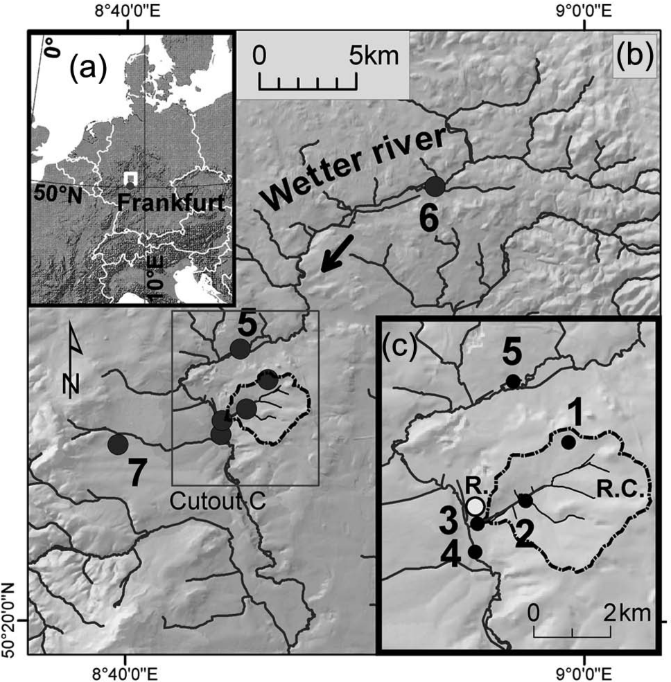
(a) Location of the study area. (b) A cutout of the course of the Wetter river in the Wetterau basin and the location of the Rockenberg catchment. (c) The Rockenberg catchment and the contiguous Wetter floodplain reaches. R.C.: Rockenberg catchment; R.: town of Rockenberg. Sampling locations: 1: Fehrgarten soil pit; 2: Seeacker soil pit; 3: alluvial (fan) section at the catchment outlet; 4: floodplain cross-section (Nolte, 2000); 5: floodplain cross-section, Ohoe, (Lang and Nolte, 1999); 6: floodplain cross-section, NB2 (Houben, 2007); 7: dated hillslope colluvia (Fengler, 2007; Fülling and Fengler, 2009)
The generally humid temperate climate with mild winters and warm summers and the fertile soilscape have supported a 7500 yr long history of continued arable cultivation (Saile, 1998; Stobbe, 1996). Small-scale, scattered clearance started with the establishment of Neolithic agricultural settlements (7500–4100 cal. BP), successively expanded and achieved an almost landscape-scale state ~ 2700 years ago (early Iron Age; Stobbe, 1996; Stobbe and Kalis, 2010). As a result, cultivation-related sediment redistribution occurred leaving a nearly ubiquitous cover of anthropogenic colluvia that bury a highly variable pattern of truncated soils (Houben, 2008). The present-day soilscape, thus, comprises a wide range from (few) near-complete Luvisols, Colluvic Luvisols and Dystric or Calcaric (Colluvic) Regosols (Entisols) with Ap epipedons to thick colluvial (cumulic) soils (cf., Schrader, 1978; WRB, 2007). The average thickness of anthropogenic colluvia is ~ 0.4 m to 0.5 m but may attain thicknesses of up to 3 m in topographic concavities. Stratified colluvia occur mainly in typical sediment- trapping positions (e.g. topographic concavities, uphill from long-term field borders; Houben, 2008). On floodplains, anthropogenic alluvium originates from silty-clayey overbank sedimentation and shows thicknesses of 1 m to 1.5 m in the subcatchments and up to 2.5 m in the Wetter river floodplain (Houben, 2003; Lang and Nolte, 1999; Nolte, 2000). The anthropogenic alluvia cap older Pleistocene to Holocene alluvial sequences, which consist basally of Pleniglacial sands and gravels that are overlain by Lateglacial overbank fines in places (Houben, 2003), gravely sands of Younger Dryas age, and greyish to blackish clays that represent the early Holocene, undisturbed alluviation (‘Black Floodplain Fines’; Houben, 2003; Kalis et al., 2003; Rittweger, 2000).
Although the northwestern Wetterau basin represents an archaeologically well documented area (e.g. Saile, 1998), the number of sites with chronometrically dated colluvial or alluvial strata of anthropogenic origin is relatively low. Kadereit et al. (2006) provide chronostratigraphic data of anthropogenic, late Bronze Age, Iron Age and later medieval colluviation at an archaeologic hillfort site at the eastern Wetterau basin margin using Optically Stimulated Luminescence (OSL) dating. Fülling and Fengler (2009) present OSL data for Neolithic to medieval colluvia on a loess hillslope in the western Wetterau basin (c. 5 km west of the Rockenberg catchment). There, a footslope colluvium was dated to the Migration period using radiocarbon dating (Fengler, 2007). For the Wetter river floodplain fills, chronologic data based on radiocarbon and OSL dating are available for an upper reach (Houben, 2002, 2007), the middle reach as well as some lower reaches (Filzinger and Dohrn, 1993; Lang and Nolte, 1999; Nolte, 2000).
Methods
Field-data collection
Two colluvial sites within the Rockenberg catchment were chosen for age determination by OSL dating because of their distinctive stratification (Figure 1c, sites 1, 2). The alluvial record at the catchment outlet was studied at an open section of 5 m depth c. 150 m downstream of the confluence of the catchment with the Wetter river floodplain (Figure 1c, site 3). Geographical coordinates were determined by handheld GPS survey. Recording pedo- and lithostratigraphic data comprised logging of depth intervals of distinct layers and horizons, texture class, structure, stoniness, colour, HCl effervescence, coatings, redoximorphic features, charcoal abundance, precipitates, concretions, and potsherd fragments (AG Boden, 1994; profile descriptions and texture codes after Schoeneberger et al., 2002). Sampling focused on retrieving one or more representative bulk samples from each soil horizon and layer of parent material.
Laboratory analytical procedures
Particle-size analysis was conducted by sieving of sand-grade fractions and applying a pipette method to silt- and clay-grade materials (Köhn pipette method as described in Hagedorn and Rother, 1992). The summary statistical parameters of mean and sorting (standard deviation) refer to moment measures as described in Tucker (1996). Total organic carbon was measured with a LECO carbon analyzer. Dithionite- and oxalate-extractable Fe, Al and Mn and pH were determined following standard procedures (Mehra and Jackson, 1960; Schwertmann, 1964), pH was measured electrometrically. Soil colour was obtained from moist samples and is given as moist Munsell colour.
Dating
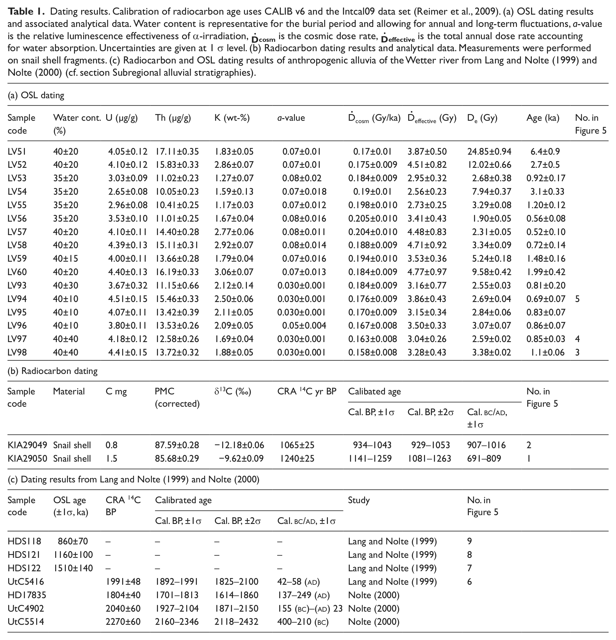
Samples for luminescence dating were taken from the centre of an individual stratum. For samples LV51-LV60 (Figure 1, sites 1, 2) a polymineral fine grain approach was used and for samples LV93-LV98 (Figure 1, site 3) quartz fine grains were extracted. Samples were treated applying conventional preparation procedures for silt-sized samples (Lang and Wagner, 1997; Mauz et al., 2002). LV91-98 were subsequently etched in 20% hydrofluoric acid for 20 min and tested to ascertain quartz purity (Mauz and Lang, 2004). Two milligram sample material was pipetted in acetone suspension onto 1 cm diameter aluminium discs. The equivalent dose (De) was derived using (1) a multiple aliquot additive dose (MAAD) protocol, IR stimulation, careful emission wavelength selection and long storage times (Lang and Wagner, 1997) for polymineral samples or (2) a standard SAR protocol (Murray and Wintle, 2000) for quartz separates. The arithmetical mean of SAR equivalent doses was used for age calculation. The activity of K, Th and U in the sediment was determined using high resolution low-level gamma spectrometry. In none of the samples was significant radioactive disequilibrium detected. Activities were converted to dose rate using conversion factors provided by Adamiec and Aitken (1998) and beta attenuation factors from Brennan (2003). The cosmic dose rate was derived from the mean burial depth of the samples (Prescott and Hutton, 1994) and a 5% uncertainty. The alpha dose of fine silt samples was corrected for alpha efficiency adopting a-values between 0.03 and 0.04 for quartz (Mauz et al., 2006) and determining a-values for polymineral samples using a calibrated 241Am alpha source. The water content was estimated on the basis of the measured field water content taking into account potential fluctuations during burial. The OSL ages are given as ka (before
To cross-check the OSL-derived chronology, at the outlet site additional AMS radiocarbon dating was performed on interbedded snail fragments and a bone fragment in the basal stratum of the anthropogenic alluvium. Radiocarbon dating was carried out by the Leibniz Laboratory, C.-Albrechts University Kiel. Radiocarbon ages are reported as calibrated ages (cal. BP) using CALIB v6 and the Intcal09 data set (Reimer et al., 2009). Radiocarbon data taken from other studies were recalibrated following Reimer et al. (2009). Other chronologic intervals are expressed as years before present and referenced to 1950, and, where appropriate, common historic dates are expressed as years
Results and discussion: Stratigraphies and chronologies of anthropogenic sedimentation
Hillslope colluviation
Two sites were investigated to unravel phases of hillslope colluviation. The first site (‘Fehrgarten’, site 1, Figure 1c) is located where a historic pilgrimage path (Gesser, 1950) perpendicularly traverses the axis of a hillslope hollow. The path has been acting as an effective barrier to sediment transfer, resulting in a flat-topped infill of the hollow uphill from the path.
A 2.5 m deep soil pit exhibited a 1.7 m thick sequence of anthropogenic colluvia showing seven distinct layers (Figure 2). The colluvial layers generally display a predominantly silty texture inherited from the erosion of loess-derived Luvisols. Towards the top, the colluvial sequence shows a gradually increasing sand component, due to incorporation of higher percentages of Tertiary bedrock when successively more and more of the silty loess-derived cover was stripped off and increasing proportions of underlying strata were eroded. The anthropogenic colluvial sequence rests upon a truncated Humic Luvisol with a dark brown argillic, 0.07 m thick remnant of a mollic epipedon and a 1 m thick sequence of two humic Bth horizons. The preserved pedostratigraphy indicates that the pre-human-impact land surface in the hillslope hollow was truncated by about 0.6–1.0 m prior to the deposition of the lowermost anthropogenic colluvium. Augering at the base of the soil pit showed that the Btb subsoil horizon is part of a Mollisol–Luvisol intergrade that developed from calcareous Pleistocene loess. The contact between late Quaternary loess and Tertiary bedrock strata lies at 3.5 m below surface (m b.s.).
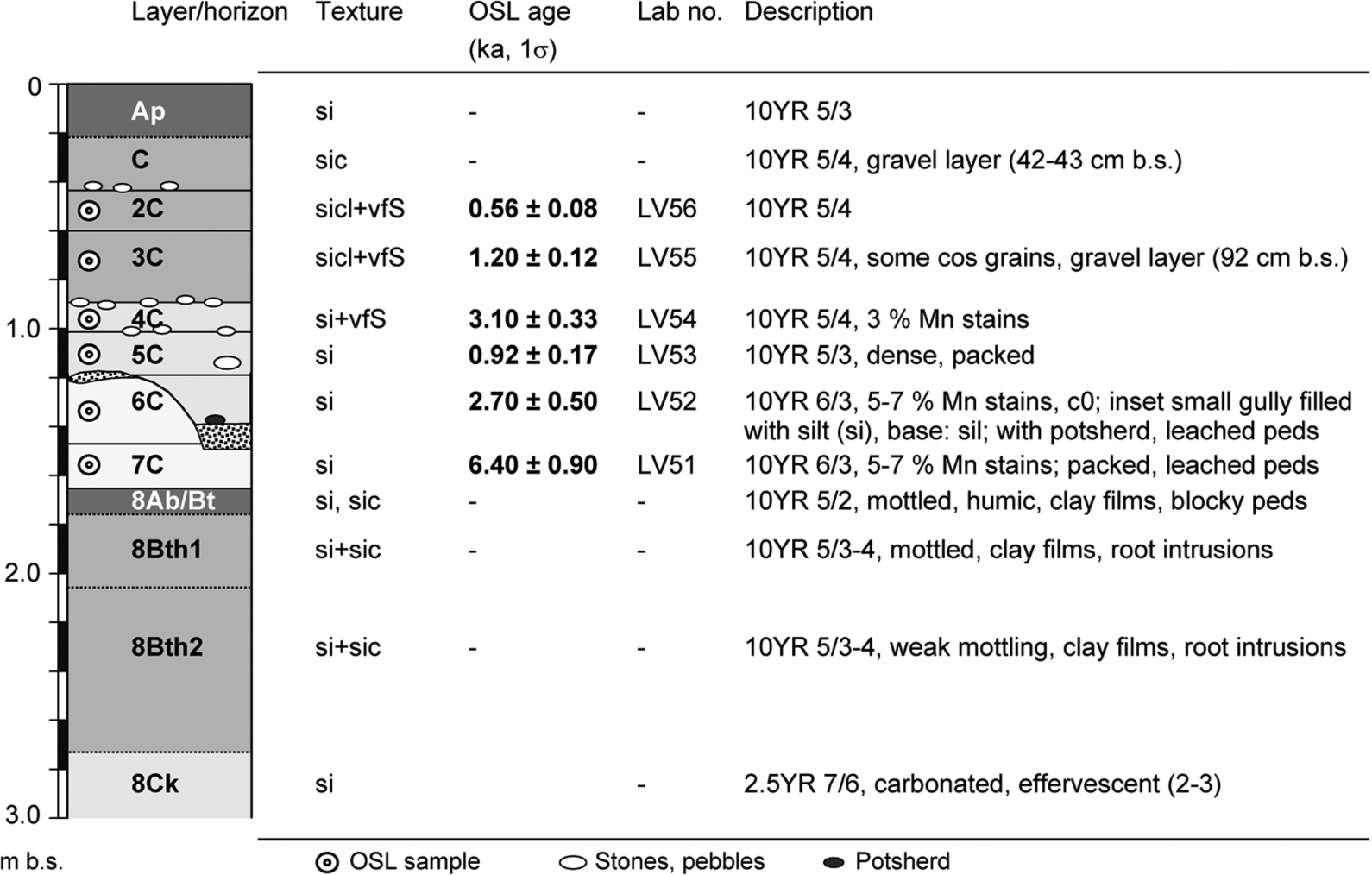
Colluvium sediment succession and analytical results of site 1, ‘Fehrgarten’ (Figure 1c). A 1.7 m thick sequence of seven anthropogenic colluvial layers rests upon a truncated Humic Luvisol. The latter marks the approximate pristine land surface prior to human settlement. The depositional age of the lowermost colluvium corroborates the presence of Neolithic agricultural activities in the study area. For further explanation see text.
Dating of the lowermost anthropogenic colluvial layer returned an age of 6.40 ± 0.90 ka (Figure 2; Table 1). The silty texture of this layer stems from the erosion of silty E horizons. In general, the lowermost colluvium is marked by a pale colour, moderate to strong grade, and abundant redoximorphic features (RMF; mostly Mn concretions, some Fe stains). With the exception of the age for LV54 OSL dating results for the sequence are stratigraphically consistent (Table 1a). Most probably this OSL age overestimates the depositional age because of poor bleaching during rapid deposition. The OSL ages of LV53 and LV55 overlap on the 1σ level. This may point to a sequence of rapid successive colluviation at some time about 1 ka ago after a small gully cut into layer 6C (Figure 2). The residual concentration of stones on the upper surfaces of the strata 4C and 2C and a relative enrichment of phosphate in 4C and 2C are indicative of longer-term stable cultivated land surfaces. To summarize, the colluvial chronology of site 1 (‘Fehrgarten’) comprises anthropogenic strata that can be attributed to four distinct depositional episodes (or perhaps events), which are probably separated by longer-term hiatuses. Concerning cultural epochs, the depositional age of the lowermost layer falls into the middle Neolithic and corroborates an early start of agricultural activities in accordance with subregional records of land use history. The overlying sequence of three colluvial beds was deposited during the late Bronze Age (Urnfield Culture) into the early Iron Age; the upper colluvial layers date to the early Middle Ages (LV53 and LV55) and Modern Times (LV56).
Dating results. Calibration of radiocarbon age uses CALIB v6 and the Intcal09 data set (Reimer et al., 2009). (a) OSL dating results and associated analytical data. Water content is representative for the burial period and allowing for annual and long-term fluctuations, a-value is the relative luminescence effectiveness of α-irradiation, D͘
The second hillslope site is the ‘Seeacker’ site (place name relates to a pond) and lies in a footslope position that became buried by a thick colluvial cover (site 2, Figures 1c, 3). Here, the Quaternary litho- and pedostratigraphy starts with calcareous loess overlying Tertiary (and/or Mesozoic) saprolite (Figure 3). In the upper part of the loess a non-calcaric Chernozem-like topsoil is preserved that marks the pristine footslope surface. Four colluvial layers overlay the buried soil: The two lower colluvial beds returned OSL ages that overlap at 1σ level (LV60 and LV59). This applies also to the next pair of colluvial strata from which the samples LV57 and LV58 were taken. Similar to site 1, the preserved stratigraphy and chronology represent local, depositional events, which here occurred during the Roman period and the late Middle Ages to Modern Times.
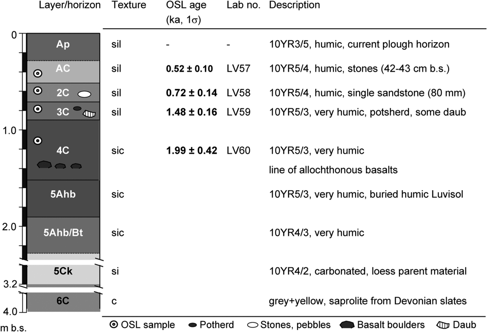
Schematic colluvial profile and analytical results of site 2, ‘Seeacker’ (Figure 1c). In a footslope position four anthropogenic colluvial layers overlay a pristine land surface that consists of a non-calcaric Chernozem-like topsoil material. For explanation see text.
Alluvial stratigraphy at the catchment outlet
To obtain a record of fluvial sediment delivery from the Rockenberg catchment, the third sample site was chosen at the confluence of the catchment with the higher-order floodplain of the Wetter river (site 3, Figure 1c). In total, the anthropogenic succession shows 12 distinct layers, two of which include buried topsoil horizons (Figure 4). The alluvial sequence starts with Lateglacial silty fines, which typically include a bed of Laacher See Tephra (at 3.44 m b.s.) and are overlain by coarse-grained Younger Dryas deposits and early-Holocene Black Floodplain Fines (BFS; Figure 4). The overlying anthropogenic alluvium is about 2.75 m thick and marked by brownish silty-clayey sediment except for the two uppermost strata that are loamier in texture. The alluvial record is not a straightforward indicator of catchment sediment delivery only. The lithologies of the anthropogenic strata vary and some strata may be derived from overbank deposition of the Wetter river, while other strata (between ~ 1.60 and 2.45 m b.s.; Figure 4) can be attributed to fan-like, fluvial deposition from more energetic flows coming from the Rockenberg catchment. The latter are obvious in the middle part and show multiple sand layers with intercalated fine gravel and thin silty beds between 1.8 m b.s. and 2.4 m b.s. In contrast, the massive clayey fines, the better-sorted lowermost anthropogenic stratum (2.45–2.78 m b.s.) and the stratum directly overlying the buried topsoil (1.3–1.7 m b.s.) may derive from fine-grained alluvial deposition on the fan-surface or from flood waters of the Wetter river.
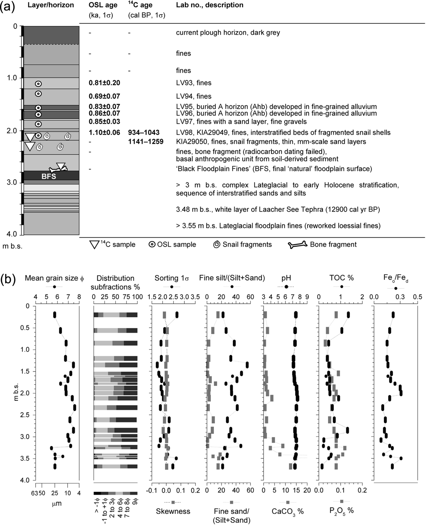
(a) Schematic representation of the alluvia found at the intersection of the Rockenberg catchment and the contiguous Wetter floodplain (site 3; Figure 1c). Differing from the colluvial sites (Figures 2, 3), at the catchment outlet anthropogenic alluviation only started about 1900 ± 100 cal. BP. The bulk of anthropogenic alluvia between 1 m b.s. and 2.45 m b.s. was deposited between
An attempt to approximate the age of the start of anthropogenic alluviation by radiocarbon dating of a bone fragment failed (Figure 4a). The beginning of local anthropogenic alluviation, nevertheless, can be approximated to 1900 ± 100 cal. BP based on lithostratigraphic correlation with a nearby dated floodplain site (OPP, site 4, Figure 1c; see next section). An OSL age is available for the directly overlying anthropogenic strata (~ 1.10 ± 0.06 ka, LV98; Table 1A; ~ High Middle Ages). Radiocarbon dating was performed on snail-shell fragments that were retrieved from the same alluvial unit (2.02–2.17 m b.s.; LV98, KIA29049; Table 1b) and its underlying stratum (2.17–2.45 m b.s; KIA29050; Figure 1a; Table 1b). The 14C ages seem reliable, were not corrected for reservoir effect because the δ13C values of the samples lie within the expected range for freshwater carbonates and confirm the OSL age estimate (LV98).
The three OSL ages (LV97, LV96, and LV95) following above are the same within error and indicate rapid aggradation around 850 years ago. The Feo/Fed ratios point to relative maturity of in situ iron (hydr)oxide weathering and support rapid aggradation: low Feo/Fed ratios (such as those of the basal anthropogenic unit between 2.3 m b.s. and 2.8 m b.s.) can result from soil-derived sediment or a longer-term in situ production of crystalline iron (hydr)oxides. High ratios (such as those between 1.8 m b.s. and 2.3 m b.s.) indicate the supply of unweathered sediment that was rapidly buried and not affected by post-sedimentary pedogenesis. Two buried humic topsoil horizons point to longer periods without alluviation. Furthermore, a higher content of phosphate indicates the presence of a longer-term used floodplain surface (Figure 4). The OSL age of 0.69 ± 0.07 ka (LV94) of the alluvial sediment overlying the A-horizons limits the period of stability to around 100 years. Allowing for a wide variability in water content resulted in a large uncertainty for the uppermost OSL age (LV93) hampering its use for constraining the sedimentation history. To summarize, the chronometric information shows that the sediment between 1 m b.s. and 2.45 m b.s. was deposited between
Subregional alluvial stratigraphies
The studies by Lang and Nolte (1999) and Nolte (2000) provide detailed stratigraphic and chronologic information from numerous drill core analyses and cross-section surveys of the middle course of the Wetter river floodplain. We use these data for a stratigraphic correlation to approximate the beginning of anthropogenic aggradation at the catchment outlet and to place changes in rates of anthropogenic alluvial aggradation in a subregional context. Total thickness of anthropogenic alluvium amounts to 2.0 m to 2.5 m on the Wetter valley floor (Lang and Nolte, 1999; Nolte, 2000). Following a millennial-scale hiatus after the formation of the early-Holocene BFS, the overlying first anthropogenic alluvium started depositing about 2200 years ago (Lang and Nolte, 1999). More than two-thirds of post-Roman alluvium accumulated within seven centuries until about 900 BP, and the thickness of the topmost modern alluvium is at most about 0.5 m.
The stratigraphic sequence and lithofacies of cross section OPP (Nolte, 2000; site 4, Figure 1b, c) ~ 490 m downstream of the confluence with the Rockenberg catchment and within the same floodplain reach shows an architecture very similar to that exposed at the outlet of the Rockenberg catchment. At the OPP site, the start of anthropogenic alluviation is dated to 1701–1813 cal. BP (HD17835; Table 1c). This dating fits into a consistent picture for the start of anthropogenic alluviation along the middle Wetter river floodplain at about 2000 years ago with some minor centennial-scale local variation (Lang and Nolte, 1999; Nolte, 2000). In the upstream preceding river reach, the beginning of anthropogenic alluviation was dated to 1892–1991 cal. BP (UtC5416), 1927–2104 cal. BP (UtC4902), and 2160–2346 cal. BP (UtC5514) for a marginal valley-floor site with possible colluvial influx (Lang and Nolte, 1999; Nolte, 2000).
The consistent alluvial lithostratigraphies on the Wetter floodplain reach of Rockenberg (sites 4, 5, Figure 1) allow using the chronostratigraphic data from Nolte (2000) to approximate the age for the basal anthropogenic alluvium at site 3 (Figures 1c, 4). Assuming that the basal layer forms a larger blanket of overbank fines, an age of ~ 1900 ± 100 cal. BP can be deduced and used for estimating conservative rates of anthropogenic alluviation at the outlet site. The approximate sedimentation rate is 0.9 ± 0.1 mm/yr for the time from the late Iron Age/Roman period to the early Middle Ages (1200 ± 100-KIA29050; Figure 5c). Calculated rates of sedimentation are 1.2 ± 0.5 mm/yr (KIA29050-KIA29049) for the early Middle Ages, 0.9 ± 0.2 mm/yr (LV98-LV97) during the early to high Middle Ages, and peak with 3.6 ± 1.7 mm/yr (LV97-LV94) in the late high to late Middle Ages. Thereafter, rates of sedimentation decrease while remaining on a relatively high level of 2.0 ± 0.3 mm/yr (LV94-present) from the late Middle Ages to the present.
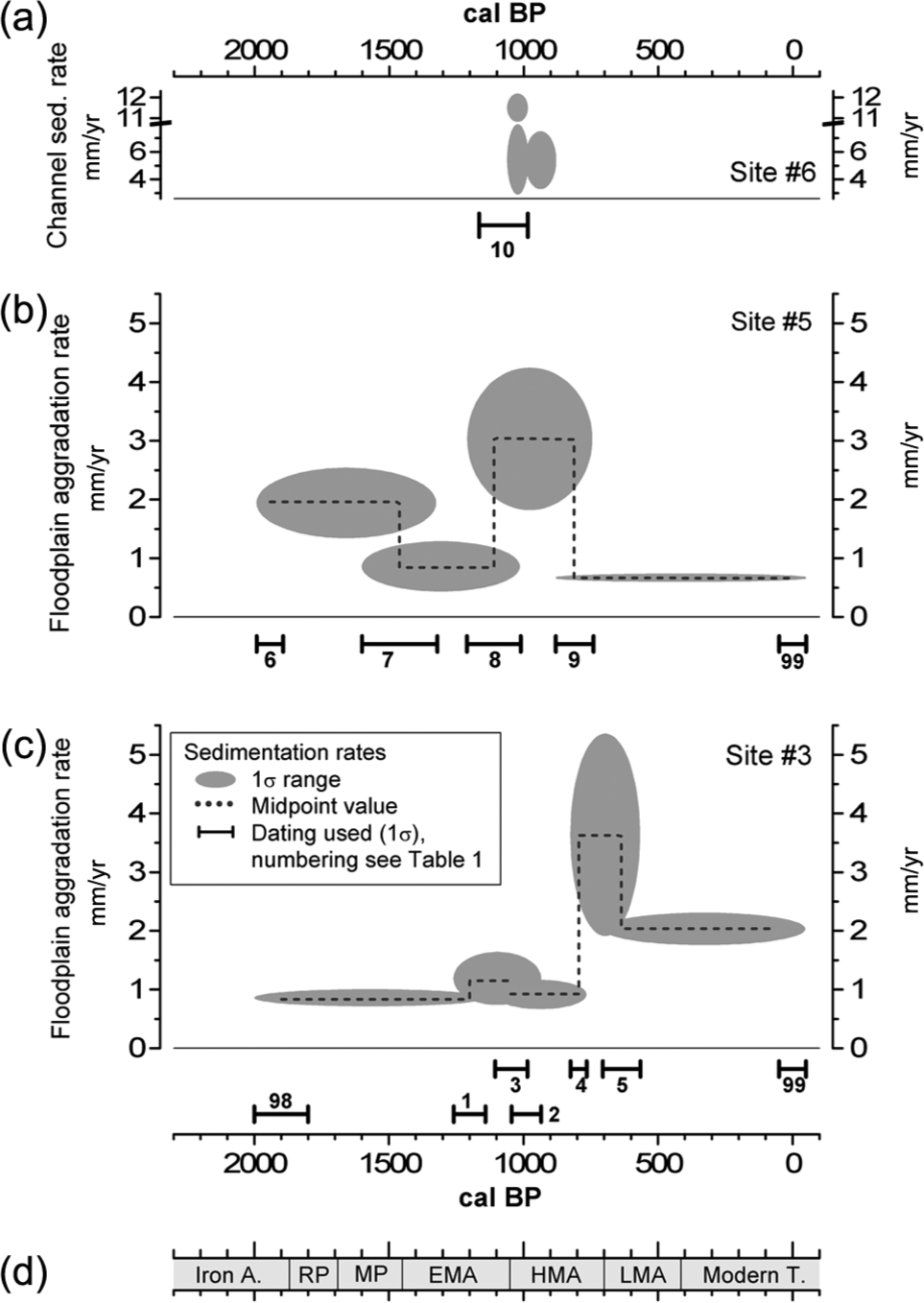
Rates of alluvial sedimentation for three different reaches in the Wetter valley (see Figure 1). (a) Upper Wetter floodplain in the piedmont zone of the upstream mountainous circum-basin area (site 6). (b) Anthropogenic floodplain aggradation in the middle Wetter river floodplain (site 5). (c) Anthropogenic floodplain aggradation in the middle Wetter river floodplain of Rockenberg (site 5). (d) Regional chronology of cultural periods (see section Study area): Iron A.: Iron Age; RP: Roman period; MP: Migration period; EMA: early Middle Ages; HMA: High Middle Ages; LMA: late Middle Ages; Modern T.: Modern Times. The 1σ confidence limits are plotted as grey ellipses. The dotted line is for visual orientation only (plotted by connecting mean values). All OSL ages are referenced to
For comparison, rates of anthropogenic alluviation at a site 6.5 km upstream based on chronologic data from Lang and Nolte (1999; site 5, Figures 1b, 5b) show initial rates of anthropogenic alluviation around 2.0 ± 0.6 mm/yr, 0.9 ± 0.4 mm/yr in the early Middle Ages, and a rise to 3.0 ± 1.2 mm/yr during the High Middle Ages. Thereafter, rates plunged down to 0.7 ± 0.1 mm/yr. A third example of a medieval interval of peaking fluvial sedimentation is reported from a floodplain reach of the upper Wetter river (site 6, Figure 1b; 15 km upstream of site 5). There, a period of rapid channel-bed aggradation occurred with rates from 5.4 ± 2.1 mm/yr to 7.4 ± 4.5 mm/yr occurring over a period of about 100 ± 30 years at around 1050–880 cal. BP (High Middle Ages; Figure 5a; Houben, 2007). These findings are corroborated by a radiocarbon age of charred wood from the basal anthropogenic alluvium that returned an age of 1166–985 cal. BP. This provides a terminus post quem for the beginning of local anthropogenic alluviation in this reach and demonstrates concurrence of floodplain and channel aggradation (Houben, 2002). Although the timing of peak alluvial aggradation is broadly synchronous for the upper and the middle reach (sites 5, 6), in the lower reach and only 5 km downstream at Rockenberg the peak sedimentation occurred about 100 to 200 years later (site 3 in Figure 1b).
In summary, within the anthropogenic aggradation history three facets are most striking: (1) the asynchronous timing of within-catchment colluvial deposition and geomorphologically effective alluvial aggradation is delayed by more than a thousand years; (2) more than 50% of the total vertical stack of anthropogenic alluvia was deposited during a 500 year period from ~ 1200 to 700 cal. BP and, thus, highest rates of floodplain aggradation occur during the High Middle Ages, which (3) still show a centennial-scale variability between different reaches of the Wetter river.
Changes of connectivity in past human–natural sediment systems
Chronologies of hillslope colluviation
The results on anthropogenic hillslope colluvia provide a chronologic snapshot of localized colluviation out of a wide range of potential chronologies of anthropogenic colluviation in the Rockenberg catchment. They are not suitable to extract larger-scale chronologies of colluviation for contiguous upslope areas or for the whole-catchment scale. The findings represent localised deposits that lack a lateral stratigraphic continuation. As shown by Houben (2008) laterally consistent colluvial lithostratigraphies extend rarely over more than 10 m to 20 m. In addition, the presence of longer-term hiati and disconformities within the colluvial sequences also hinders extracting larger-scale chronologies of colluviation. Nevertheless, from the hillside dating records it is unambiguous that anthropogenic colluvial deposition began as late as ~ 6400 years ago (Neolithic) in the Rockenberg catchment.
Our findings agree with Fülling and Fengler (2009) who report colluviation at a loess hillslope ~ 5 km to the W of the Rockenberg catchment starting in the early Neolithic and spatially complex colluvial stratigraphic layers representing all subsequent land use phases. The timing of local anthropogenic colluviation seems in phase with arable cultivation as deduced from archaeologic and palynologic evidence, a common feature of loess watersheds in central Europe (e.g. Kadereit et al., 2010; Lang, 2003)
Millennial-scale asynchrony of colluviation and alluviation
In the northern Wetterau basin, no close temporal relationship occurs between the beginning of arable agriculture and the beginning of subregional anthropogenic alluviation. Periods of highest settlement densities occurred ~ 7200 ± 100 to 6800 ± 100 cal. BP in the early Neolithic (Linear Pottery Culture), 2800 ± 150 cal. BP to 2700 ± 150 cal. BP during the late Urnfield period, and 1870–1690 cal. BP in the Roman period (cf. Saile, 1998; Zimmermann et al., 2009) and pre-date periods of significant anthropogenic floodplain aggradation. Also, maximum land clearance, maximum extent of open grazing and arable land on the loess hillsides occurred from about 3100 ± 100 to 2350 ± 100 cal. BP (Stobbe, 1996, 2008) – pre-dating the onset of anthropogenic floodplain sedimentation by several centuries. Even the Roman period (1870–1690 cal. BP), characterised by widely open, intensely used, and densely settled loess hillsides is not linked chronologically to a phase of pronounced floodplain alluviation or minerogenic sediment supply to peat bogs (Nolte, 2000; Stobbe, 1996, 2009).
A significant temporal offset between the beginning of agricultural hillslope colluviation and a geomorphologically significant alluvial aggradation through the supply of soil-erosion derived sediment to floodplains is an often recorded phenomenon of European watersheds. A variety of authors report a millennial-scale lag of alluvial aggradation beginning only in the Bronze Age (Brown and Barber, 1985; Fuchs et al., 2010), the Iron Age (Allée and Lespez, 2006; De Moor et al., 2008; Lang and Nolte, 1999; Lespez et al., 2008; Niller, 2001; Notebaert et al., 2009; Verstraeten et al., 2009), or even later in the Middle Ages (Brown, 2009; Hagedorn and Rother, 1992; Havlícek, 1983; Kukulak, 2003; Macklin et al., 2010).
While Brown (2009) points out the potential of land-use factors to change the hydrosedimentary connectivity between tilled landscape components, more commonly, a direct causal relationship between alluvial aggradation and clearance and subsequent cultivation of previously forested areas is assumed from the broad coincidence of fluvial change and regional settlement history (Bichet et al., 1999; De Moor et al., 2008; Fuchs et al., 2010; Rommens et al., 2006). Settlement density and the degree of open ground in a landscape, however, represent some attributes of land use only. They do not substantiate information on how the sediment transfer is operating across hillslope surfaces and along valley axes. The effective physical pathways of anthropogenic sediment redistribution depend on: (1) changes in rates of sediment redistribution in a landscape component, (2) the spatial organisation of landscape components (structural connectivity), and (3) the degree of hydrosedimentary connectivity between tied landscape components (functional connectivity; cf. Brierley et al., 2006; Lexartza-Artza and Wainwright, 2009; Van Rompaey et al., 2001). Whereas processes of colluvial deposition are characterised by a close spatio-temporal proximity (Lang et al., 2003), alluvial sedimentation results from spatially and functionally more complex fluxes of sediment between different landscape components. Changes in alluvial sedimentation are strongly influenced by the spatial organisation as well as the functional (hydrosedimentary) connectivity between upcascade components, and, thus, largely independent from processes of sediment redistribution on hillslopes (e.g. Trimble, 1983).
In the northwestern Wetterau basin, the boundary conditions of anthropogenic sediment redistribution on cleared hillsides have remained almost constant from late Bronze Age into Iron Age prehistory (Saile, 1998; Stobbe, 1996). It is likely, therefore, that the start of late Iron Age alluvial sedimentation was not related to changing boundary conditions but a landscape-scale change of hillslope–floodplain connectivity. The latter can be inferred from a novel spatial organisation of land use that is reflected in the regional vegetation record (Stobbe, 1996, 2008, 2009): The establishment of a land-use system that linked widely cultivated loess hillsides with extensive pastoral and grassland farming on cleared valley floors. A widely open loess landscape was present since ~ 3100 cal. BP (late Bronze Age, Urnfield Culture), but on low- and higher-order floodplains localised grassland farming only started in the middle Bronze Age and gradually expanded from ~ 3700 cal. BP onwards (Stobbe, 1996). Intensified floodplain use with first hay meadows came into existence about 2800 ± 150 cal. BP to 2700 ± 100 cal. BP with the culturally distinctive late Urnfield Culture (late Bronze Age). The final intensification and diversification of floodplain use with expanding meadowlands and pastoral farming took place in the Iron Age from 2700 ± 100 cal. BP to 1950 ± 100 cal. BP and eliminating floodplain forests (Hallstatt and La Tène Culture, Iron Age; cf. Stobbe, 1996, 2008, 2009; Stobbe and Kalis, 2010). In this period, first occasional influxes of soil-derived sediment into Holocene floodplain swamps are noted (Stobbe, 2009). Additional indicators of a novel proximity of arable cultivation on hillslopes and increasingly open, used floodplain areas are higher values of pollen of Poaceae, Cyperaceae, and classic wetland species.
We postulate that the onset of anthropogenic alluvial aggradation was related to the introduction of a land use system of intense cultivation on hillsides and immediate floodplains starting from the Iron Age. The spatial proximity brought about novel structural elements of hillslope–floodplain connectivity. The connectivity is provided by dirt roads, paths, animal tracks, as well as the removal or breaching of valley-side vegetational barriers to sediment flux, and possibly simple technical field drainages as reported for Iron Age cultivation (Brown, 2008). All these represent efficient conduits for sediment transfer at the hillside–floodplain interface (see also Brown, 2009; Froehlich and Walling, 1997; Jackson et al., 2005). Later, starting a few decades before the Roman period, woody vegetation resurged on valley floors and subsequently was not part of the Roman land use system (Stobbe, 1996, 2009; Stobbe and Kalis, 2010). This interval of decoupled hillslope–floodplain settings is associated with the lack of minerogenic sediment supply into marginal floodplain swamps (Stobbe, 2009). Furthermore, Lang and Nolte (1999) and Nolte (2000) report a corresponding decrease of rates of alluvial sedimentation during the Roman and the Migration periods. Ceasing alluviation while prominent colluvial deposits develop on hillslopes has also been observed by Lang (2003), Kalis et al. (2003), Dreibrodt et al. (2010), Kadereit et al. (2010) in other Roman occupied landscapes of southwestern Germany. It reflects the contrastive Roman land use system with well-organized agriculture on hillsides and abandoned floodplains. It also underpins the significance of the spatial reorganisation of land use that comes along with important socio-(agri)cultural transformations (e.g. Brown, 2009).
Some studies show a first occurrence of anthropogenic alluvium in parallel with Neolithic settlement activities (e.g. Hiller et al., 1991; Tinapp et al., 2008). These studies focus on Neolithic settlements that border directly on alluvial sediment sinks, indicating that the close temporal relationship of settlement and alluvial stratigraphy relates to the close spatial proximity (Lang, 2003).
Medieval sediment pulses: A side-effect of medieval energy production?
Many authors have attributed the build-up of thick, soil-derived alluvium to medieval settlement and intense cultivation in previously forested areas (e.g. Allée and Lespez, 2006; Bertran, 2004; Klimek et al., 2006; Lewin, 2010; Mensching, 1957; Stolz and Grunert, 2008), independent of climatic factors or the clustering of extreme rainfall events (Brown, 2008; Macklin et al., 2010; Robinson and Lambrick, 1984; see overview in Notebaert and Verstraeten, 2010). This accords with histories of settlement and alluviation in the mountainous surroundings of the upper Wetter watershed. In these circum-basin areas, following the decline of Roman rule in the 3rd century
By contrast, deforestation cannot explain the occurrence of high medieval sediment pulses in the middle to lower Wetter valley floors in the basin area (Figure 5b, c). Here, the surrounding loess hillsides show continuing intense cultivation and settlement from Roman times through the Migration period and into the Middle Ages (~ 1700 to 1350 cal. BP; Austermann, 1999; Fengler, 2007, see site 7 in Figure 1bB; Singer, 2009; Steidl, 2000; Stobbe, 1996). In southern Germany, intense post-Roman land use focused on the loess areas within the formerly fortified Roman border (limes). This area includes the loess catchments of the middle and lower Wetter river but excludes the upper circum-basin sub-watersheds. The post-Roman social transformation involved a return to a pre-Roman style of cropping and land use pattern (Stobbe, 1996). Later, settlement activities intensified from 5th century
In the case of the loess areas of the northwestern Wetterau basin, nevertheless, the introduction of the socio-agricultural transformation of the High Middle Ages precedes peak floodplain aggradation in the middle Wetter valley by about 200 ± 100 years (floodplain site 5) and 400 ± 100 years in the Rockenberg reach (sites 3, 4; Figure 1c). Thus, the temporally and spatially variable occurrence of peak floodplain alluviation cannot be attributed to the introduction of intensified cultivation alone because the latter started earlier and continued in existence until the late 18th century
Given the spatio-temporal variability of the medieval sediment pulse, it seems likely that localised human activities temporally changed the structural controls of hillslope–floodplain and floodplain–floodplain connectivity. A plausible explanation is the introduction and subsequent alteration of hydraulic water milling infrastructure on valley floors (cf. Walter and Merritts, 2008). Water milling was essential to the medieval socio-economic transformation as much as the novel field system. Hydraulic milling spread across temperate Europe in the 8th and 9th century
The earliest mention of a water mill on the Wetter floodplain in Rockenberg dates to
Water milling activities may have played a significant role for causing the observed spatial variability and diachrony of peaking floodplain aggradation in the High Middle Ages. The technology was available and its immediate and sizeable impact on sediment transfer would fit well to the pattern observed in the sedimentary records. A test of this hypothesis will have to await better archaeological and historical information about medieval water milling in the different reaches of middle Wetter river.
Conclusions
Thick, tabular sediment bodies of cohesive fines are characteristic for floodplains in the loess regions of Central and Western Europe. The blanket-like deposits are often of several meters thickness and have long been recognised as anthropogenic deposits. We show that the evolution of these deposits is clearly linked to human impact, is far more heterogeneous than the prevailing theory suggests and is highly variable spatially and temporally. In the middle Wetter valley two most prominent changes in Holocene alluviation can be related to changing system connectivity resulting from socio-agricultural transformations. Our findings indicate that for millennia agricultural activities caused sediment redistribution on hillslopes while floodplain morphology was hardly affected. From prehistoric times to the Migration period little or no sediment connectivity between slopes and adjacent floodplains existed and channels within vegetated wetlands characterised the valley bottoms. Here, little clastic sediment accumulated but substantial amounts of organic carbon. During the medieval period novel spatial organisation of land use and the widespread introduction of hydropower with direct human alteration of the functional connectivity completely transformed the sediment transfer from tilled hillslopes to floodplains. Floodplain sedimentation rates strongly increased beyond the range of 1 mm/yr to 2 mm/yr, that had persisted before and re-established after the medieval sedimentation maxima (and which may be interpreted as the regional ‘anthropogenic background rate’ of floodplain sedimentation). During the medieval period and owing to the small-scale character of individual hydro power structures sedimentation was spatially highly variable. The medieval sedimentation of about 1.2 ± 0.3 m of anthropogenic alluvium significantly transformed the morphological, hydrological, ecological, and agricultural conditions of the subregional floodplain setting. This environmental transformation of floodplains took place over an interval of a couple of centuries only. By the end of the Middle Ages a thick, tabular sediment body of fines blanketed older floodplain surfaces and floodplain wetlands had disappeared. Owing to the cohesive nature of the alluvium stream flow is since channelised along stable, laterally immobile and relatively entrenched channels. The correponding lower groundwater-tables ease the drainage of temporally wet floodplain areas, and turn former wet low-lying land into terrace-like landforms allowing warping and seasonally longer periods of pastural and grassland farming. Regarding cause-and-effect in a sequence of human–environment interactions, the medieval floodplain aggradation improved the land use potential in the valley bottoms and constitutes a positive but unintended side effect. Furthermore, the maintenance of mill sites probably also benefited from the novel fluvial settings that were marked by stable channel morphologies.
The causal understanding of sediment redistribution and alluvial records in coupled human–natural systems requires firm information about the spatial organisation as well as the (socio-agricultural) management of land use (Brown, 2008; Houben, 2012; Trimble, 1983; Trimble and Lund, 1982). Unravelling the evolution of historical landscapes in central Europe – including problems of interdependencies of environmental transformation and the exploitation of ‘natural’ resources by human societies – will have to focus more on establishing spatially and temporally commensurable records of land use and anthropogenic environmental change through collaborative efforts of historical and natural sciences.
Footnotes
Acknowledgements
Uwe Radtke, Heinrich Thiemeyer, Simone Hahn, Tobias Schrod, Jan Voss, Jürgen Wunderlich, and Michael Schmidt are thanked for assisting in the field. In particular, Heinrich Thiemeyer is thanked for his can-do attitude and enabling rather big exposure pits and for generously supplying funds for OSL dating of the alluvial-fan sequence. Warm thanks are due to Ingo Schulz and Berthold Antony who granted access to cropped fields at any time and occasion. Doris Bergmann-Dörr and Dagmar Schneider are acknowledged for conducting the sediment and soil laboratory analyses. Pieter Grootes and his co-workers of the Leipniz Laboratory (University of Kiel) are thanked for the collaborative conduct of radiocarbon dating. Finally, we are grateful to the anonymous reviewers who made helpful comments.
Funding
This work was supported by the Deutsche Forschungsgemeinschaft (DFG grant no. TH-572/1-1).