






Abstract
Sand dune stratigraphy, radiocarbon-dated charcoal layers, palaeosol development and luminescence dating are used to reconstruct the Holocene environmental history of the dune fields in Finnish Lapland since deglaciation in the early Holocene (~10,900–10,200 cal. BP). After rapid formation and stabilisation of parabolic dunes and the immigration of Scots pine (Pinus sylvestris), forest fires are inferred to have played a key role in triggering episodes of aeolian erosion of the dunes (deflation) leading to 16 sand dune re-activation events. These events were widespread in the dune fields from ~8300 cal. BP and occurred with increasing frequency towards the late Holocene. Each event is interpreted as relating to local fires that occurred up to 100–400 years after the date of each charcoal layer; the radiocarbon age of the charcoal being affected by the age of the wood when burned, and the accumulation and/or recycling of charcoal from earlier fires. Well-developed buried iron podzols, which can develop within 500–1000 years, indicate prolonged phases of dune stability, four of which are dated to between 4500 and 1050 cal. BP. Indirect associations are evident between the sand dune re-activation events and climatic phases that were relatively cold and/or wet. These associations are explained by a conceptual geo-ecological model in which the effects of century- to millennial-scale climatic variability are modulated by the interactions between fire and vegetation. Thus, the subarctic dune field is viewed as a heterogeneous landscape of stable and unstable areas in space and through time. The unstable elements of this spatial mosaic become more extensive at times when the climatic environment promotes fire and deflation.
Keywords
Introduction
Generally, aeolian activity is an important geomorphological process in the subarctic and periglacial environments (Seppälä, 2004). Such activity affects and is affected by other aspects of the geo-ecological system and is a sensitive indicator of environmental, including climatic change (Koster, 1988; Mason, 2012). In particular, extensive dune fields may dominate the landscape where a sparse vegetation cover is combined with sufficient unconsolidated sediment for erosion, transport and deposition of sand by wind, or where dense vegetation is disturbed sufficiently to expose the underlying sediments to aeolian activity.
In Finnish Lapland, fields of parabolic dunes were formed shortly after early-Holocene deglaciation (Johansson, 2007), aeolian activity being promoted by extensive, sparsely vegetated glacial, glaciofluvial and glaciolacustrine sediments. The subsequent stabilisation and re-activation history of the dune fields have been investigated by several authors, including Seppälä (1971, 1995), Kotilainen (1991, 2004), Vliet-Lanoë et al. (1993), Tikkanen and Heikkinen (1995) and Käyhkö et al. (1999). In this and other regions, re-activation has been attributed to various environmental disturbances often involving interactions between forest fires and climatic change (see, for example, Barrett et al., 2013; Filion, 1984; Gavin et al., 2006; Hu et al., 2006; Krawchuk et al., 2009a; Parisien and Moritz, 2009; Seppälä, 1981; Wotton et al., 2010).
Although the evolution of subarctic aeolian landscapes is still poorly understood, knowledge of the chronology of events has benefited from the development of radiocarbon dating and, more recently, luminescence dating. The former has been applied to buried charcoal layers and palaeosols in the dunes, while the latter has been applied to the sand matrix itself (see, for example, Käyhkö et al., 1999; Kotilainen, 2004; Seppälä, 1971; Vliet-Lanoë et al., 1993). Thus, there is the possibility of investigating the history of stable phases of vegetation and soil development, and unstable phases represented by dune re-activation triggered by forest fires and affected by climatic changes. Most previous studies have been limited, however, by their chronological control, which has been insufficient to produce a representative picture of the events that have occurred throughout the Holocene.
The overall aim of the present study is to reconstruct the Holocene environmental history of the dune fields of Finnish Lapland in greater detail than has been attempted hitherto and hence to understand better the palaeoenvironmental implications of subarctic aeolian landscapes. This has been possible by focusing on a reliable chronology of events from numerous stratigraphic profiles within and between dune fields. Specific objectives include the following: (1) dating the formation and stabilisation of the original parabolic dunes using luminescence dating, (2) radiocarbon dating of the sequence of forest fires and dune re-activation events based on buried charcoal layers, (3) dating buried palaeopodzols indicative of phases of dune stabilisation, (4) determining whether or not there was a general centennial- to millennial-scale pattern of events across the dune fields related to climate (taking into account earlier research as well as the new data from this study) and (5) exploring and elucidating the dynamic interrelationships between vegetation, soil development, forest fires, dune re-activation, palaeosol formation and climatic change.
Study area, materials and methods
This study focuses on six dune fields in all (Figure 1). New data are presented from four dune fields: Hietatievat (H), Kahilatievat (K), Pasmajärvi (P) and Kuttanen (Ku). Extensive use is also made of previously published dates, most notably those from two dune fields investigated by Kotilainen (2004): Iijärvi (I) and Mutusjärvi (M).
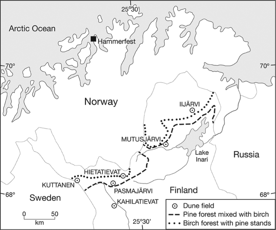
Location of the dune fields investigated at Hietatievat, Kahilatievat, Pasmajärvi and Kuttanen in this study, and by Kotilainen (2004) at Iijärvi and Mutusjärvi. The present northern limits of pine forest mixed with birch and birch forest with pine stands are based on the Atlas of Finland (Alalammi, 1988: map 5a).
Deglaciation of the areas occupied by these dune fields, which range in altitude from 200 to 350 m a.s.l., took place between 10,900 (Iijärvi) and 10,100 (Kuttanen) years ago, as the last ice sheet retreated across the region from the north-east towards the south-west (Johansson, 2007; Johansson et al., 2011). The present mean annual air temperature ranges from −0.5°C to −1.5°C (Alalammi, 1987). Winters are severe, and the mean annual precipitation is about 400 mm, >50% of which occurs from June to September. Frozen ground and a snow cover in winter mean that sand redistribution is confined to the summer months (Seppälä, 1971, 1995).
All sites are north of latitude 68°N and close to the present limit of pine forest as defined in the Atlas of Finland (Alalammi, 1988) (Figure 1). The dune fields are today in either the Scots pine (Pinus sylvestris), downy birch (Betula pubescens) or mixed pine–birch forest zones and have been under pine forest for most of the Holocene (Hyvärinen, 1976; Kultti et al., 2006; Seppä, 1996). Pine invasion into Finnish Lapland occurred by about 9000 years ago, the pine forest attaining its maximum extent and density ~8000–6000 years ago and retreating subsequently (possibly with fluctuations) to its present northern limit (Kultti et al., 2006).
Stratigraphy was examined in sample trenches at sites where redeposited sand was most likely to have buried and preserved palaeosols and charcoal layers. These depositional sites were on the lee side of active or revegetated blow-outs where evidence of erosional activity was usually absent. In all, 17 trenches were then enlarged and the profiles logged in detail. Where possible, the trenches were extended down to the stratified sand (foreset bedding) of the original parabolic dune. The latter could be clearly differentiated from the unstratified nature of redeposited sand produced by dune re-activation (Kotilainen, 2004; Seppälä, 1995). Buried iron podzols were identified and characterised by the thickness and intensity of the bleached A2 horizon and the underlying dark brown to orange-brown Bs horizon (cf. Mokma et al., 2004; Schaetzl and Anderson, 2005). Presence of charcoal was recorded as distinct layers of almost pure charcoal and, less commonly, dispersed specks and streaks of charcoal within redeposited sand.
Charcoal samples for radiocarbon dating were taken from all charcoal layers from each profile. Some layers were too thin to be dated or a combined date was obtained for two closely spaced layers. Occasionally, additional dates were obtained to test for reliability. These additional dates included (1) replicate samples from the same layer, (2) fine and coarse charcoal fractions of the same sample, (3) partially charred wood associated with a charcoal layer and (4) charcoal widely dispersed within a sand layer. Conventional radiocarbon dating was carried out at the Swansea Radiocarbon Dating Laboratory. Pretreatment involved wet-sieving and flotation to separate the charcoal from the sand; the quantity of the latter having been minimised by careful scraping of the charcoal layers with a trowel from the pit walls. Rootlets were removed from the samples by hand-picking, and a standard acid/alkali/acid wash sequence was used to minimise chemical contamination from humic substances. The 68 radiocarbon dates were calibrated using the programmes and data sets of Stuiver and Reimer (1993), Stuiver et al. (1998) and Reimer et al. (2004) using calibrated age ranges (±2σ) and most probable age ranges alongside intercept ages.
In order to identify temporal patterns in the age distribution of the calibrated radiocarbon dates, forest fires and sand dune re-activation events, our dates were combined with 61 dates published by Kotilainen (2004) and others in simple cumulative and cumulative weighted distributions using 100-year class intervals consistent with the statistical and interpretive errors discussed in the following. Individual dates were represented in the weighted distributions by a range of 300 years, centred on the intercept age weighted twice, using a modification of the approach first proposed by Occhietti and Hillaire-Marcel (1977), see also (Matthews et al., 2005; Morin and Payette, 1988). Although this simple graphical technique ignores the potentially complex shapes of probability density functions (cf. Telford et al., 2004), when combined with careful analysis of the individual calibrated dates, it provides a powerful method for identifying interpretable age clusters. In order to check that the clusters are real, they were analysed, using one-sample χ2 tests, with the null hypothesis that the dates represent a random sample from an underlying population of dates with an even temporal distribution. Rejection of the null hypothesis would, therefore, suggest the existence of clusters.
Luminescence dates were obtained from laminated sand at the base of four profiles (one profile from each of the Hietatievat, Kahilatievat, Pasmajärvi and Kuttanen dune fields) and from redeposited sand at higher levels. Samples of sand (volume of 1000 cm2) were taken from the exposed profiles using sections of plastic drainpipe with a square cross section. Thermoluminescence (TL) and/or infrared-stimulated luminescence (IRSL) dates were obtained from nine sand samples at the Cheltenham Luminescence Dating Laboratory, with the expectation that the IRSL dates would be the more reliable because of relatively rapid bleaching of the luminescence signal on exposure of sand grains to sunlight (Aitken, 1998; Clarke, 1996; Liridzis et al., 2013; Madsen and Murray, 2009).
Results
Dune stratigraphy
All stratigraphic profiles are summarised in Figure 2, focusing on the position of the radiocarbon and luminescence dates in relation to the charcoal layers and palaeosol horizons. Photographs of selected profiles are shown in Figures 3–5. Details of the dates are listed in Tables 1 and 2. Excavations were sufficiently deep to locate laminated sand at the bases of at least two profiles from each dune field. Above this, unlaminated, redeposited sand extends to the surface and is generally covered with a complete vegetation cover but little or no modern soil development. The charcoal layers and palaeosols within the redeposited sand vary in thickness but generally exhibit little evidence of disturbance and are often laterally continuous for tens of metres.
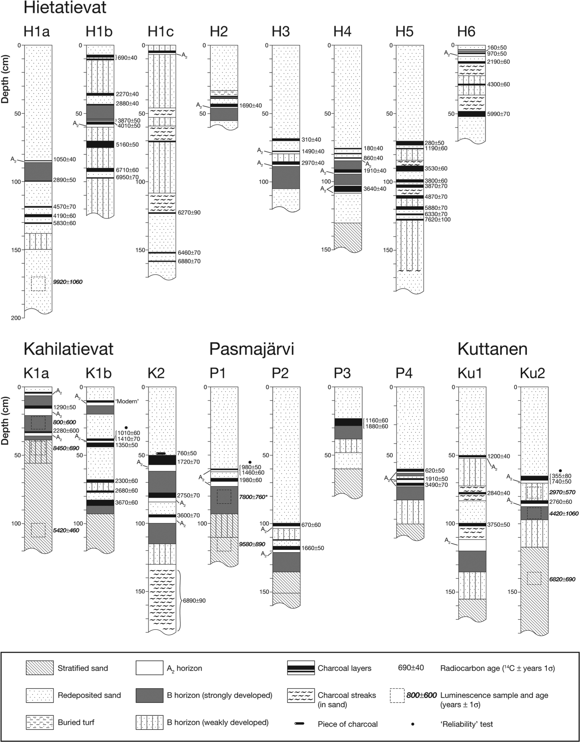
Stratigraphic profiles from four dune fields: Hietatievat (H), Kahilatievat (K), Pasmajärvi (P) and Kuttanen (Ku). Note that profile H1a is from the crest and H1b and H1c are from the foot of the distal slope of the same dune. K1a and K1b are also from the crest and distal slope of a single dune. Details of the radiocarbon dates, including explanations for more than one date from the same level, are given in Table 1. With one exception (*) luminescence dates shown are IRSL dates (see also Table 2 and text).
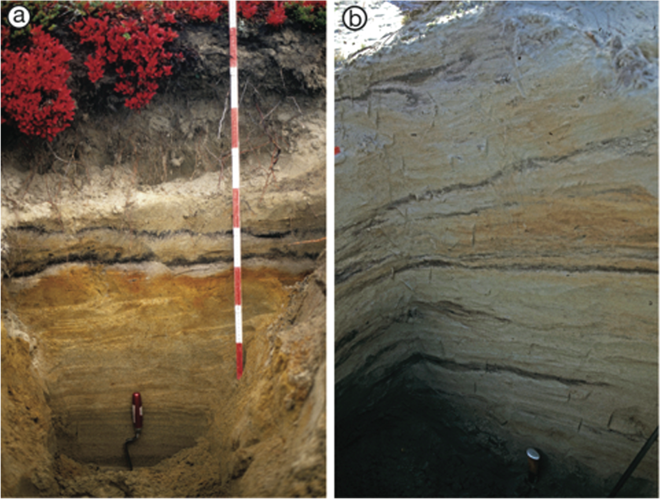
Photographs of (a) a relatively simple profile from the Pasmajärvi dune field (P1), showing a well-developed palaeopodzol beneath the lower of two distinct, horizontal charcoal layers dated to 1980 ± 60 radiocarbon years BP (an IRSL date of 9580 ± 890 years was obtained from laminated sand at the base of this profile) and (b) the most complex profile from the Hietatievat dune field (H1b), where there is evidence of 10 charcoal layers dipping at 22° and dating from 690 ± 40 to 6950 ± 70 radiocarbon years, and several poorly developed palaeopodzols (see Figure 2 for further interpretation).
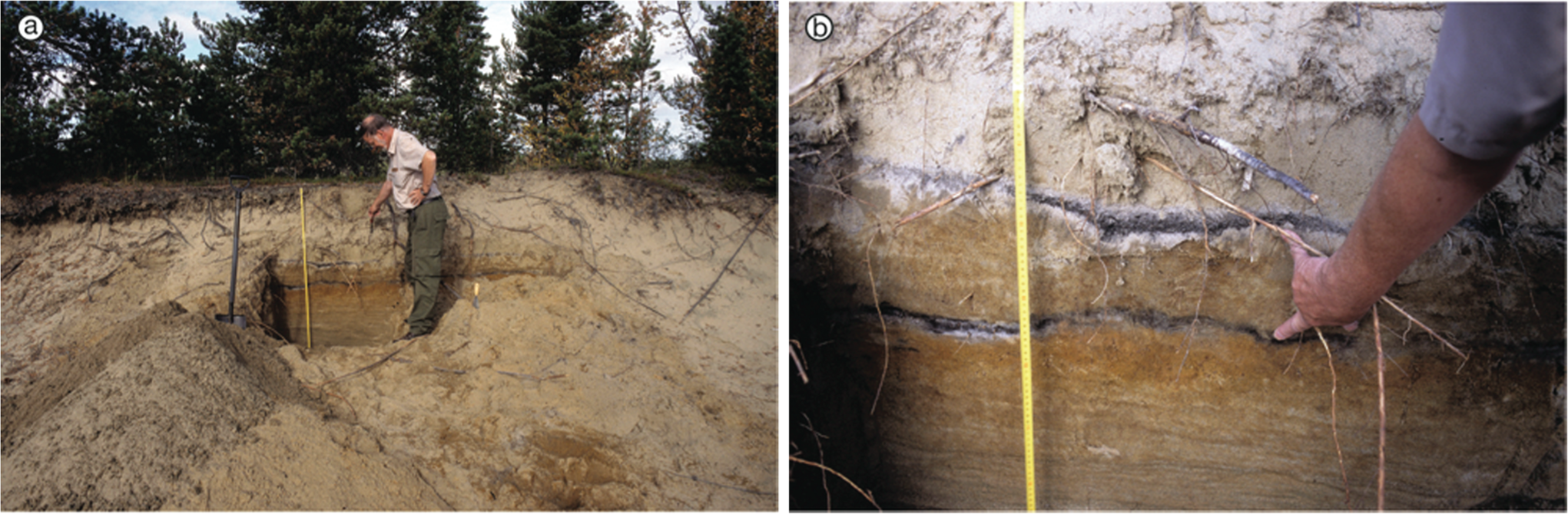
Photographs of profile Ku2 from the Kuttanen dune field: (a) the setting of the site with pine and birch trees growing on the dune and (b) two palaeopodzols, beneath charcoal layers dated to between 355 ± 80 and 2760 ± 60 radiocarbon years, respectively. Note the weak Bs horizon despite a clear A2 horizon associated with the upper charcoal layer. An IRSL date of 6820 ± 690 years was obtained from laminated sand at the base of the profile (see also Figure 2).
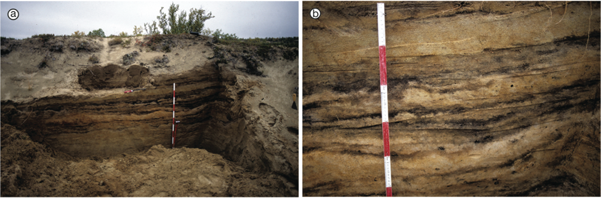
Photographs of profile H5 from the Hietatievat dune field: (a) the setting of the site with birch scrub growing on the dune and (b) evidence of nine charcoal layers dated to between 280 ± 50 and 7620 ± 100 radiocarbon years BP, zones of sand containing streaks of charcoal and some weak podzolisation. An IRSL date of 9920 ± 1060 years was obtained from laminated sand at the base of this profile (see also Figure 2).
Radiocarbon dates from buried charcoal layers at four dune fields: Hietatievat, Kahilatievat, Pasmajärvi and Kuttanen. Calibrated age 1 (Stuiver et al., 1998) gives the intercept age (in brackets) ±2σ. Calibrated age 2 (Reimer et al., 2004) gives the most probable age range and its probability (p, in brackets).

Two distinct charcoal layers.
Mainly uncharred wood.
Fine fraction (<2 mm).
Coarse fraction (>2 mm, hand-picked from the sample).
Single piece of partially charred wood on top of charcoal layer.
Partly charred wood within charcoal layer.
Two dates on apparently the same charcoal layer, 20 m apart.
Replicate dates on same charcoal layer, 2 m apart.
Infrared-stimulated luminescence (IRSL) and thermoluminescence (TL) dates from four dune fields: Hietatievat, Kahilatievat, Pasmajärvi and Kuttanen (see also Figure 2).

Palaeosols
Most profiles are characterised by evidence of podzolisation in the form of bleached (albic) A2 horizons of 0.5–5.0 cm thick and well-developed orange (spodic) Bs horizons up to 20 cm thick (Figure 2). However, the lower limit of the Bs horizon is often difficult to define as weak iron staining may extend much deeper in the profile. In Figure 2, therefore, the distinction is made between well-developed and weakly developed Bs horizons. One or two well-developed Bs horizons occur in most profiles, with particularly good examples at Pasmajärvi (Figure 3a) and Kuttanen (Figure 4b).
Charcoal layers
Charcoal distribution within the profiles tends to be concentrated as distinct layers of macroscopic particles ranging from 0.5 to 7.0 cm thick but mostly 1–2 cm thick (Figure 2 and Table 1). Zones of sand containing charcoal fragments or streaked with charcoal (see, for example, H5 in Figures 2 and 5b) are less common. Three to 10 discrete charcoal layers characterise the profiles at Hietatievat, the radiocarbon age of which range from 160 ± 50 to 7620 ± 100 radiocarbon years (±1σ). There are fewer charcoal layers at Kuttanen, Kahilatievat and Pasmajärvi, where the oldest charcoal dates are 3750 ± 50, 3670 ± 60 and 1980 ± 60 radiocarbon years, respectively (Figure 2 and Table 1).
Radiocarbon dates
Importantly, the radiocarbon dates from the charcoal layers are in chronological order within all profiles (Figure 2). Moreover, age differences between adjacent layers are mostly statistically significant. On account of 1σ confidence intervals of ±70 radiocarbon years or less for almost all dates, an age difference between samples of ~200 and 300 years (±2σ) is necessary for it to be regarded as statistically significant. Thus, in the few cases where adjacent charcoal layers differ in age by <300 years, they cannot be regarded as significantly different in age.
This statistical interpretation is reinforced by additional information available from Kahilatievat (dune K1). In this dune, the uppermost three charcoal layers in profile K1a were traceable laterally into profile K1b (at 7 m horizontal distance), where the middle layer bifurcates to form two separate layers (Figure 2). Apart from the upper charcoal layer, these layers were dated in both profiles. The radiocarbon date of the second layer in profile K1a of 1290 ± 50 radiocarbon years BP (SWAN-315) differs by about 310 and 60 cal. yr, respectively, from the two dates on the equivalent layers in profile K1b (SWAN-474a and SWAN-474b; Table 1). Similar physical connections between adjacent charcoal layers within the larger dune at Hietatievat (profiles H1a–H1c) could not be established because of erosion in the blow-out between the profiles. Physical connection between adjacent charcoal layers was also not established between what nevertheless appeared in the field to be the same charcoal layer at 20 m horizontal distance at Pasmajärvi (profile P3; SWAN-484 and SWAN-485; Table 1).
Another ‘reliability test’ of the age variability within the same charcoal layer was made at Kuttanen (profile Ku2), where samples at 2.0 m apart horizontally yielded ages of 350 ± 80 and 740 ± 50 radiocarbon years (SWAN-492 and SWAN-491, respectively): the calibrated age difference of about 320 years (Table 1) is statistically significant. Within-layer age variability of a different type is exemplified by the ages of 1410 ± 70 (SWAN-474a) and 1010 ± 60 (SWAN-474b) radiocarbon years obtained for finer and coarser fractions, respectively, from the same layer at Kahilatievat (profile K1b; Table 1); the age difference of about 375 calendar years is again statistically significant.
Partially charred wood at Pasmajärvi (profile P1; SWAN-321; 1460 ± 60 radiocarbon years; Table 1) is about 415 calendar years older than the charcoal layer in which it was embedded (SWAN-320; 980 ± 50 radiocarbon years). Interestingly, the partially charred wood at Kahilatievat (profile K2; SWAN-481; 760 ± 50 radiocarbon years) is about 1000 years younger than the underlying charcoal layer (SWAN-479; 1720 ± 70) on which it rested.
Luminescence dates
The luminescence dates are far less accurate than the radiocarbon dates, confidence intervals being an order of magnitude greater (Table 2). The large confidence intervals mean that (1) the apparent age differences between IRSL and TL dates (where both are available) are not statistically significant at the 2σ (95%) confidence level and (2) the luminescence dates are compatible with the radiocarbon ages of adjacent charcoal layers. Furthermore, with one exception (the basal sample at Kahilatievat), the luminescence dates are generally in chronological order within the profiles. They, therefore, complement the radiocarbon dating, especially in providing constraints on the age of the laminated sand. Excluding the basal sample from Kahilatievat owing to an unexplained age inversion, the four remaining IRSL dates on the laminated sands range from 6820 ± 690 (profile Ku2) to 9920 ± 1060 (profile H1a) years.
Discussion
Luminescence dates and the formation and stabilisation of the original parabolic dunes
The oldest IRSL dates of 9920 ± 1060 years at Hietatievat (profile H1a) and 9580 ± 890 years at Pasmajärvi (profile P1) located near to the surface of the original parabolic dunes are consistent with their formation and stabilisation shortly after Fennoscandian Ice Sheet deglaciation of these areas around 10,250–10,300 years ago (Johansson, 2007). Kotilainen (2004) obtained even older IRSL dates from dune sands lying immediately above glaciofluvial sediments at Mutusjärvi (10,700 ± 1200 years) and Iijärvi (10,200 ± 1200 years), which relate to the initial stage of dune formation at these sites following their deglaciation 10,600–10,900 years ago. However, the wide confidence intervals (±1σ) of all four dates mean that parabolic dune growth and activity could have continued until much later. This possibility is consistent with the younger dates of 8450 ± 690 and 6820 ± 690 years obtained from laminated sand at Kahilatievat (profile K1a) and Kuttanen (profile Ku2), respectively, and also with the luminescence dates published by Seppälä (1995), Vliet-Lanoë et al. (1993) and Käyhkö et al. (1999).
Kotilainen (2004) concluded that the original post-glacial dunes stabilised by about 8700 years ago, based on her earliest calibrated radiocarbon ages at Mutusjärvi and Iijärvi, while earlier authors (Käyhkö et al., 1999; Seppälä, 1995) favoured somewhat later dates for the initial stabilisation. Although the earliest calibrated radiocarbon age from Hietatievat (profile H5) of about 8400 years (SWAN-318; Table 1) is consistent with stabilisation some 2000 years after deglaciation, the charcoal layer involved (and presumably those investigated by the other authors) occurs in redeposited sand, which is likely to be the result of later dune re-activation.
Thus, the evidence currently available suggests that the earliest parabolic dunes of at least some dune fields formed and stabilised shortly after deglaciation. Although parabolic dune formation requires at least a partial vegetation cover (Seppälä, 1971, 2004), rapid vegetation development stabilises dunes by reducing sand supply. Under the rapidly warming climate that followed deglaciation, it is likely that a tundra vegetation and later birch and then pine trees were involved in stabilising the dunes (Hyvärinen, 1976; Seppä, 1996; see also Barnekow et al., 2008; Carcaillet et al., 2012). Consequently, in favourable sites, dune surfaces may have stabilised within as little as a few hundred years after deglaciation. However, at less well-vegetated sites, particular dunes may have remained active for much longer (possibly up to 2000 years or more).
Interpreting the radiocarbon dates from the buried charcoal layers
The interpretation of radiocarbon dates derived from charcoal involves five important interrelated questions, as follows:
To what extent is the charcoal inert?
What was the age and type of wood from which the charcoal was derived?
Do the charcoal layers represent single fires?
Was the charcoal produced locally (more or less in situ)?
Do the charcoal layers contain recycled (allochthonous) carbon?
Charcoal is generally considered a highly suitable medium for radiocarbon dating because it is relatively inert (Forbes et al., 2006; Preston and Schmidt, 2006; Schmidt and Noack, 2000; Stout et al., 1981) and therefore avoids many of the complex problems associated with dating most other forms of soil organic carbon, which decompose over time (Matthews, 1985). Although recent studies have shown that the charcoal content of boreal forest soils decreases with time (Ohlson et al., 2009), with decomposition by fungi and bacteria playing a role (Pietikäinen et al., 2000), this destruction of charcoal is likely to diminish or cease after burial and to be at very low levels during the cold winter months at and near the treeline ecotone. The survival of the buried charcoal layers in the dune fields demonstrates, moreover, that charcoal can survive over the Holocene timescale.
Charcoal originating from wood has an apparent or ‘inbuilt age’ (Gavin, 2001; Gavin et al., 2003), which is inherited from the age of the wood when the charcoal is produced. The maximum age of living Scots pine trees is about 800 years, but most very old pines attain ages of little more than 300 years, and the oldest birch trees are much younger (Farjon, 2005; Finnish Forest Research Institute, 2007; Kirchhefer, 2001). Most of the charcoal is believed to have originated from pine rather than birch. This is consistent with extensive investigations of the palaeobotany of charcoal samples from Finnish Lapland, including many samples from the dune fields (Rudner and Seppälä, 2005). The predominance of pine charcoal can be attributed to the presence of pine at most sites for most of the Holocene, the greater volume of wood in the pine trees (even in mixed pine–birch forest), the open structure of birch forests and low stature of birch trees beyond the pine treeline (and hence the corresponding lower susceptibility of pure birch forest to fire) and the tendency of birch to produce ash rather than charcoal (Matthews et al., 1995). Standing or fallen dead pine trees, which occasionally exist for millennia, may exceptionally contribute to charcoal production (the charred wood of SWAN-481 at Kahilatievat possibly being an example of this), but survival of such old dead wood is more likely in waterlogged sites (Eronen et al., 2002). However, as pine trees of these ages are rare, and much of the charcoal produced is likely to originate from forest floor material, sub-canopy trees and young branches (Fréjaville et al., 2013; Niklasson and Granström, 2000; Scott, 2010), the inbuilt age factor is considered unlikely to exceed ~100–150 years.
The presence of distinct, relatively thin charcoal layers in chronological order in the dunes is consistent with single, local fire events producing charcoal rapidly buried by accumulating sand. Macroscopic charcoal is generally considered a reliable environmental indicator of local fires (Clark and Royall, 1995; Clark et al., 1998; Lynch et al., 2004; Ohlson and Tryterud, 2000; Ohlson et al., 2006; Whitlock and Larsen, 2001; Whitlock and Millspaugh, 1996; but see Scott et al., 2000; Tinner et al., 2006). Furthermore, the much less common occurrence of charcoal particles dispersed among the redeposited sand in Finnish Lapland argues against its widespread redistribution by wind. Most of our layers are therefore correctly described as ‘charcoal layers’ rather than ‘charcoal-rich layers’, a term that has been used elsewhere (e.g. Jansen et al., 2013) for layers with a substantial sand content. However, the existence of very thin, closely spaced charcoal layers suggests not only that relatively thick layers could represent the accumulation of charcoal from more than one fire but also that thin layers might not be preserved unless rapidly buried.
Charcoal lying on the ground surface is likely to be consumed partly or completely by the next fire (Payette et al., 2008). However, significant age variations within individual charcoal layers of ~300–400 years (revealed by the ‘reliability tests’) suggest that some layers (especially the thicker ones) contain appreciable quantities of charcoal produced by more than one fire. The charcoal could have been emplaced by the in situ accumulation of autochthonous charcoal from successive fires, or the recycling of allochthonous charcoal from previous fires by subaerial surface processes. Unfortunately, no tests were made for an age–depth relationship within the layers (cf. Matthews and Dresser, 1983), which has the potential to distinguish between these two possibilities.
Although the possibility of larger errors affecting particular dates cannot be ruled out in dune fields where extensive blow-outs show that wind action is significant, we presume that the charcoal was locally derived and more or less in situ, and that the charcoal layers relate to single fires (in which case each layer may be up to 100–150 years older than the age of the fire that created it) or, in some cases, a number of fires that occurred over ~300–400 years. Thus, the charcoal ages are interpreted as close maximum age estimates of the fires that created the charcoal layers.
Relationships between the ages of charcoal layers, forest fires and redeposited sand
If the age of a charcoal layer represents a maximum age estimate of the fire(s) affecting the vegetation on the dunes, it leads to the question of the relationship between the charcoal age and the age of the redeposited sand. This requires consideration of the crucial role of the vegetation cover in determining the stability of sand dunes. Wind erosion is usually rare in densely vegetated areas (Wondzell and King, 2003). Forested dunes typically remain stable until the vegetation cover is disturbed by fire (or some other environmental factor), and the sand is exposed to aeolian erosion (i.e. the process of deflation; Seppälä, 2004). Deflation is most intense immediately after a fire, and may continue until the dune becomes protected by vegetation following recolonisation and succession.
The process of succession, which is generally slow in subarctic and subalpine environments, and on sand, probably requiring many hundreds of years to restore a forest cover, may nevertheless produce a more-or-less complete cover of mosses, lichens, grasses and scattered shrubs in less than a century (cf. Matthews, 1992, 1999; Walker and del Moral, 2003). However, as shown by Vliet-Lanoë et al. (1993), there is evidence of deflation and sand drifting associated with blow-outs continuing in certain places at Hietatievat for at least 700 years. A new re-activation of deflation could, therefore, occur from an existing, open blow-out without the intervention of fire.
In general, after a fire, residual material, including charcoal, forms a fragile surface layer that is often redistributed rapidly by wind and subaerial processes and can be removed from hillslopes within weeks after burning (Doerr and Shakesby, 2013). Seppälä (1984) showed that a 2- to 3-cm-thick layer of sand was commonly drifted each year from open blow-outs at Hietatievat dune field, which indicates that the charcoal layers could be rapidly buried by the redeposited sand in accumulation areas. Where a light surface vegetation of mosses and lichens survives a fire, this provides ideal condition for temporary charcoal storage because vegetation holds the charcoal in situ until it is covered by sand. Conversely, the absence of vegetation may explain why charcoal layers are absent from active blow-out surfaces shortly after fires.
It is proposed, therefore, that the age of a charcoal layer represents not only a near maximum age for the forest fire(s) that created it, but also a near maximum age for the sand dune re-activation event(s) that buried and preserved it. Indeed, each radiocarbon date is likely to be as close an estimate of the age of the re-activation as it is of the fire that created it. Although the luminescence ages from redeposited sand (Figure 2; Table 2) are also compatible with this proposal, the precision of luminescence dating is too poor to test it.
Sand dune re-activation events during the Holocene
The age distribution of the calibrated radiocarbon dates from the charcoal layers is analysed in Figure 6 with a view to identify temporal patterns in the frequency of both forest fires and dune re-activations. Temporal patterns are unclear in the data from the four dune fields shown site by site in Figure 6a, but begin to emerge in the cumulative distribution of Figure 6b (upper graph, H-Ku; n = 77) in which these dates (n = 68) are combined with a further nine from the literature. The dates are widely spread throughout most of the Holocene but tend to increase in frequency towards the late Holocene with peak frequency between about 500 and 1000 years ago. The same general pattern is recognisable in the data from two other dune fields (Figure 6b, middle graph, M/I; n = 61), mainly from Kotilainen (2004), and accentuated by combining all the data together (Figure 6b, lower graph, all; n = 138), which also suggests some clustering of dates.
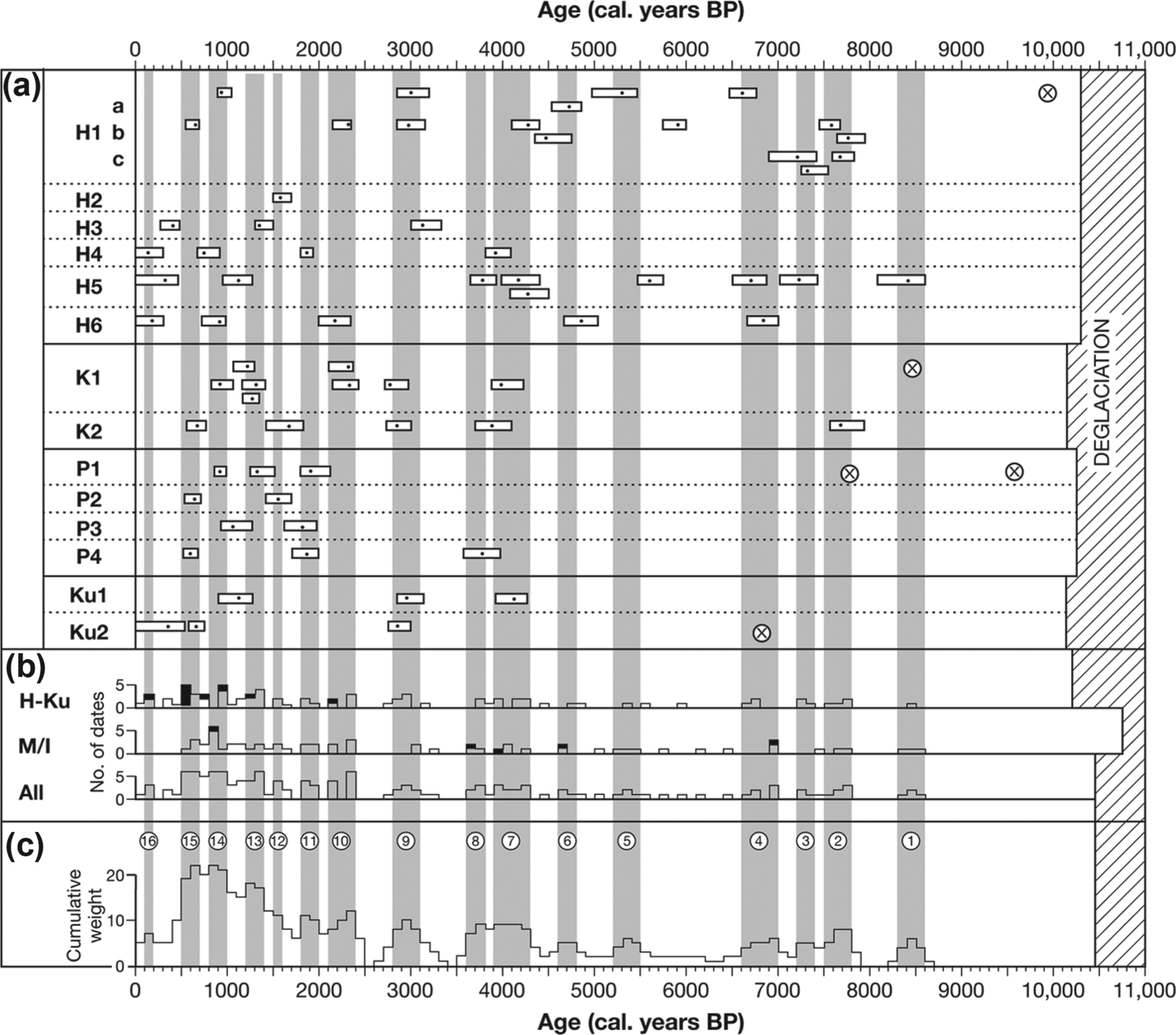
Age distributions of calibrated radiocarbon dates on buried charcoal layers in sand dunes in Finnish Lapland: (a) individual radiocarbon dates and their 95% confidence intervals for each profile at four dune fields: Hietatievat (H), Kahilatievat (K), Pasmajärvi (P) and Kuttanen (Ku). Note also IRSL dates for laminated sand indicated by crosses. (b) Cumulative distributions of intercept ages of the radiocarbon dates from all profiles at the four dune fields using a 100-year class interval (upper distribution); similar data from Kotilainen (2004) for the Mutusjärvi (M) and Iijärvi (I) dune fields (middle distribution), and the combined data set from all six dune fields (lower distribution). Black shading in the upper and middle distributions indicates additional published radiocarbon dates from Seppälä (1995) and Käyhkö et al. (1999). (c) Cumulative weighted distribution of the intercept ages for the combined data from the six dune fields (each date is plotted over a 300-year interval with the middle class weighted twice). Diagonal shading to the right indicates coverage by the Fennoscandian Ice Sheet based on Johansson (2007). Grey columns identify 16 numbered centennial- to millennial-scale clusters of charcoal dates and hence forest fires: sand dune re-activation events (Table 3) correspond to the end-date of these clusters (see text for further explanation).
In all, 16 centennial- to millennial-scale clusters of radiocarbon dates can be recognised primarily on the basis of the weighted cumulative distribution (Figure 6c). Definition of these clusters takes into account the unweighted distributions and whether closely spaced charcoal layers differ significantly in age. One-sample χ2 tests, based on the use of all available dates from the six dune fields in Figure 6b (lower graph), 250-, 500- and 1000-year class intervals over 9000 years, and a probability level of p < 0.05, lead to rejection of the possibility of a uniform distribution of dates through time in all three tests and hence point to the validity of seeking clusters in these data. The timing of the 16 clusters is summarised in Table 3 along with the timing of the associated sand dune re-activation events. The latter are defined as the end-dates of the numbered age clusters shown in Figure 6c. Defining dune re-activation events in this way as single points in time recognises that deflation is initiated immediately after each forest fire, while allowing for an age overestimate of 100–400 years (depending on the age range of the cluster).
Centennial- to millennial-scale clusters of forest fires and sand dune re-activation events defined in radiocarbon-dated charcoal horizons from six dune fields in Finnish Lapland (see also Figure 6).

Although Kotilainen (2004) distinguished only five ‘re-activation phases’ of 300–1700 years duration (and fewer clusters are distinguished if a wider class interval is used to construct the histograms), recognition of a relatively large number of re-activation events can be justified on three main grounds. First, the large data set presented here increases the potential for recognising events that are closely spaced in time. Second, the results from the individual profiles and dunes demonstrate the existence of many more events than have been recognised in previous studies (Käyhkö et al., 1999; Kotilainen, 2004; Seppälä, 1995). For example, at least 8 separate events are present in a single profile (H5) and at least 10 in a single dune (H1) at Hietatievat, where there is evidence to support all 16 events (Figure 6a). However, because of the local extent of fires, dependence of the spread of each fire on the contemporaneous wind direction and the potential for erosion, no charcoal layer is found consistently across all profiles, even in a single dune. Third, the high frequency of forest fires in the boreal forest is consistent with a large number of re-activation events in a heterogeneous landscape. Although the frequency of fires varies greatly in space and time (Barrett et al., 2013; Payette et al., 2008), various estimates indicate that fire frequency or recurrence interval in Fennoscandian and North American boreal forests is normally within the range of 1 in 50–250 years (Haapanen and Siitonen, 1978; Pitkänen and Huttunen, 1999; Pitkänen et al., 2002; Sirén, 1961; Terasmae and Weeks, 1979; Zackrisson, 1977). Values tend to be near the high end of this range within fully developed pine forest (Tolonen, 1983). Fire frequency, however, is likely to have been lower in the treeline ecotone, in mixed pine/birch forest and in birch forest (for reasons relating to forest structure and composition discussed earlier).
The available charcoal data from the dune fields indicate fairly frequent fire activity and associated dune re-activation throughout the Holocene. It must remain an open question as to whether the first dune re-activation event (8700–8300 calendar years BP) was preceded by others that have not been recorded because of the lack of sufficient trees, especially pine trees, in the early Holocene. It should be borne in mind, however, that fires may occur in shrubby tundra, in the absence of trees, although at reduced frequency (Filion et al., 1991; Hu et al., 2010; Landhäusser and Wein, 1993; Payette et al., 1989). Pollen analysis indicates that pine migrated into Finnish Lapland by ~9000 cal. BP (Hyvärinen, 1976; Kultti et al., 2006; Seppä, 1996) preceded by birch, while pollen and pine megafossil evidence suggests the pine forest reached its maximum extent and density of ~8000–4500 cal. BP and then retreated towards its present position (Eronen et al., 2002; Kultti et al., 2006).
Systematic differences in the evolution of the dune fields have been suggested in previous studies by both Käyhkö et al. (1999) and Kotilainen (2004). They attributed such differences to such factors as location within the birch or pine forest zones and the pattern of pine immigration. In the present study, for example, Pasmajärvi appears to have been unstable only during the last 2000 years. However, the high level of variability encountered within a relatively small number of profiles cautions against such generalisations. In particular, the history of such studies shows that the length and complexity of the record of sand dune re-activation events have increased in direct proportion to the intensity of sampling.
Podzolic soil formation and prolonged episodes of landscape stability
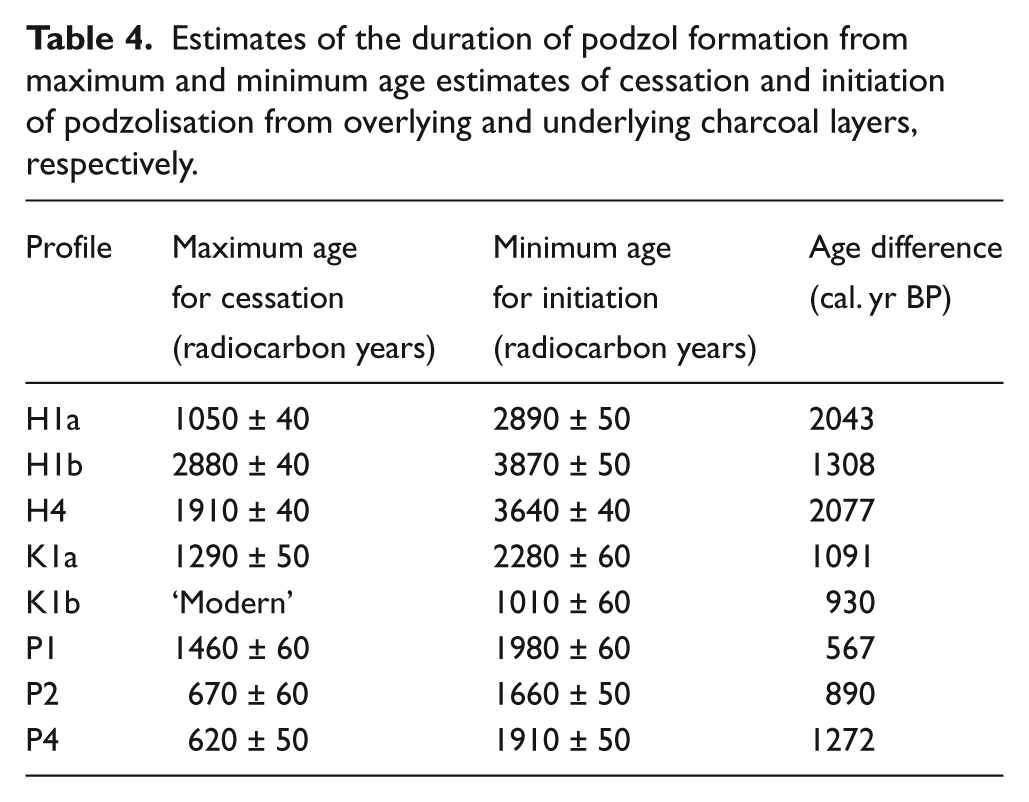
In contrast to dune re-activation events, podzolisation results from the relatively long-term soil forming processes of leaching of minerals and/or organic compounds from the A2 horizon and their precipitation in the illuvial Bs horizon (Schaetzl and Anderson, 2005). Nevertheless, the charcoal horizons place constraints on when the podzols began to form (their absolute age) and when their formation ceased following burial (cf. Matthews, 1985). Radiocarbon dates from charcoal layers overlying podzols provide maximum age estimates of when the latter ceased to form, whereas radiocarbon dates underlying them provide minimum age estimates for when formation commenced (although the latter are less likely to be close estimates). Table 4 shows the eight cases from the dune profiles where both maximum and minimum age constraints can be applied to podzols defined by us as having well-developed Bs horizons. The resulting conservative estimate for the duration of development of these podzols has a mean of 1272 years with a range of 567–2077 years.
Estimates of the duration of podzol formation from maximum and minimum age estimates of cessation and initiation of podzolisation from overlying and underlying charcoal layers, respectively.
Such durations are similar to or slightly longer than independent estimates obtained on the emergent coastal plain of northwestern Finland, where ‘visually apparent’ podzols form within 400–500 years (Jauhiainen, 1973) and a ‘typical’ podzol may take 500–1000 years (Aaltonen, 1952). In northern Sweden, ‘perceptible’ podzols can form within 100 years, while a ‘normal’ podzol with 10-cm-thick A2 horizon and 25- to 50-cm-thick B horizon requires 1000–1500 years (Jenny, 1941; Tamm, 1950). These estimates for the duration of podzol formation are fully compatible with much larger absolute ages for podzols with similar horizon thicknesses that are fully developed (see, for example, Ellis and Matthews, 1984; Mokma et al., 2004).
Using the assumption that our well-developed Bs horizons require ~750 years to develop, phases of podzolic soil formation in the dunes are shown in Figure 7 with reference to the 18 calibrated radiocarbon dates from charcoal that provide close maximum estimates for the cessation of podzol formation. The phases of podzol formation (depicted by shaded columns in Figure 7) are defined as the maximum overlap between the presumed duration of development of 16 of the podzols. Each of the four phases (1500–1050, 2300–1800, 3600–3000 and 4500–3900 calendar years BP) is based on at least three of the individual estimates. Traces of earlier phases of podzolisation exist in the profiles but cannot be defined in the same way because the record is too fragmentary.
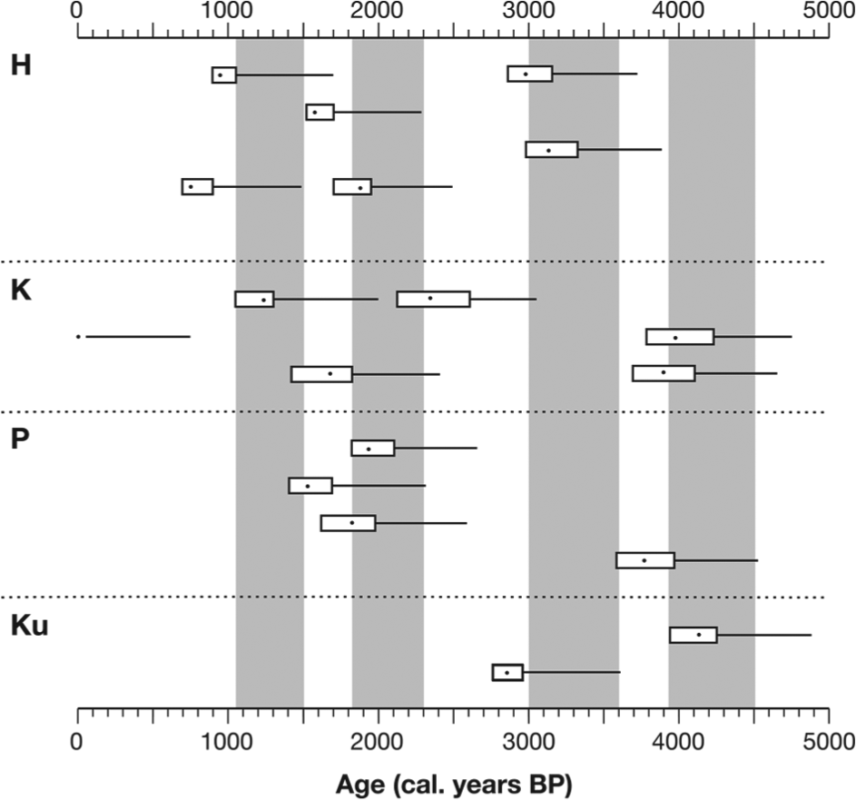
Four phases of podzol formation (shaded columns) defined by radiocarbon dates from buried charcoal layers at Hietatievat (H), Kahilatievat (K), Pasmajärvi (P) and Kuttanen (Ku) dune fields, assuming that well-developed podzols require ~750 years to form. Individual calibrated radiocarbon dates are shown with 95% confidence intervals. Horizontal lines extending from each date indicate a time interval of 750 years before the intercept age of the charcoal sample (see text for further explanation).
Relationships to climatic variability during the Holocene
Substantial climatic variability during the Holocene is now firmly established both regionally (Bakke et al., 2008; Gunnarson et al., 2003; Jansen et al., 2008; Jensen and Vorren, 2008; Korhola and Weckström, 2004; Matthews and Dresser, 2008; Matthews et al., 2005; Seppä and Birks, 2001, 2002; Snowball et al., 2004; Vorren et al., 2012) and globally (e.g. Bond et al., 2001; Mayewski et al., 2004; Renssen et al., 2012; Verschuren and Charman, 2008; Wanner et al., 2008, 2011). The extent to which centennial- to millennial-scale climatic variations play a role in accounting for the temporal pattern of forest fires, sand dune re-activation events and phases of podzolisation in Finnish Lapland, therefore, presents an intriguing research problem. Some suggestions arise from considering the proxy records of Holocene climatic variations summarised in Figure 8.
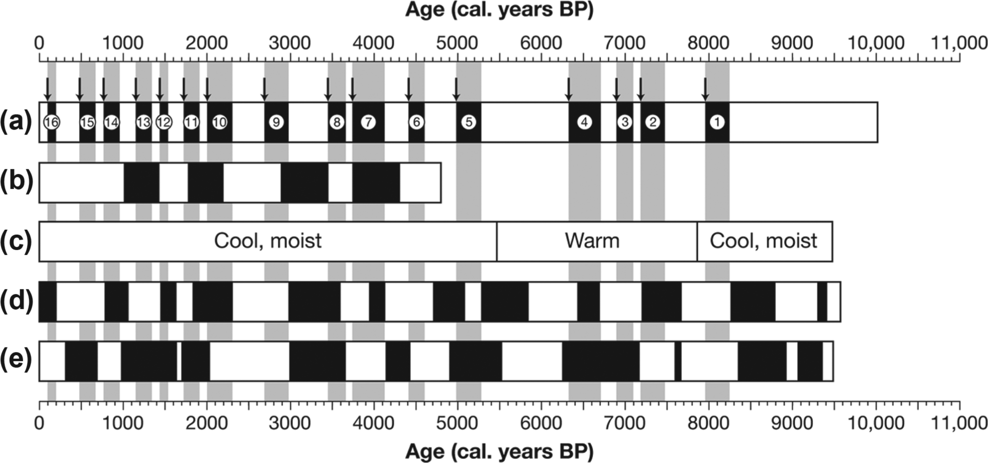
Holocene temporal pattern of charcoal dates, sand dune re-activation events and palaeosol development in Finnish Lapland in relation to proxy indicators of palaeoclimatic variations: (a) centennial- to millennial-scale clusters of charcoal dates (numbered) and hence forest fires and dune re-activation events (arrows) in Finnish Lapland from Figure 6; (b) phases of podzol formation in Finnish Lapland from Figure 7; (c) multi-millennial pattern of climate in Northern Finnish Lapland (after Seppä and Birks, 2001); (d) warm (shaded) and cold (unshaded) temperature anomalies in Greenland, based on ice-core data (Alley, 2004) and (e) wet (shaded) and dry (unshaded) precipitation anomalies in northern Finland, based on pollen analysis (Seppä and Birks, 2002; Wanner et al., 2011) (see text for further explanation).
In relation to long-term (Holocene) millennial-scale variability in climate in Finnish Lapland, the number and frequency of forest fires and sand dune re-activation events (Figure 8a) increased in the late Holocene, which was increasingly cool and moist (Seppä and Birks, 2001). All four phases of podzol formation also occurred in the late Holocene (Figure 8b). However, three of the four earliest dune re-activation events occurred during the warmest part of the Holocene, which is defined by Seppä and Birks (2001) as 8200–5700 cal. BP in Finnish Lapland (Figure 8c; see also Seppä et al., 2004). Clearly, therefore, any relationship between fire, aeolian activity, podzol formation and climate cannot be a simple one.
Similarly, there is no close agreement between dune re-activation events and the shorter, centennial- to multi-centennial patterns in climate summarised in Figure 8d and e. The warm and cold phases shown in Figure 8d are positive and negative temperature anomalies, respectively, derived from GISP2 ice-core data (Alley, 2004) as standardised by Wanner et al. (2011), which are believed to be representative of the North Atlantic region, including Northern Europe. The wet and dry phases shown in Figure 8e are comparable positive and negative precipitation anomalies, respectively, derived for northern Finland from pollen transfer functions for northern Finland (Seppä and Birks, 2002), again standardised by Wanner et al. (2011). Analysis of the number of dune re-activation events falling within the warm, cold, wet and dry phases indicates a preference for cold phases and a weaker preference for wet phases: 66% of the 16 dune re-activation events occurred within cold and 56% within wet phases. Forest-fire clusters also exhibit a slight preference for cold and wet phases: while 53% of the forest-fire clusters occurred in cold phases, 56% occurred within wet phases.
An explanation for these weak associations may be provided by the complexity of the interactions between climate, vegetation cover and fire. Cold and wet conditions, for example, are likely to be associated with weather systems bringing strong (and drying) winds that would promote both deflation and fire, while elevated precipitation would increase vegetation growth, which would also enhance fire. However, during summer 1972, which was very hot and dry in Utsjoki, northernmost Finnish Lapland, some 60 local forest fires occurred in July, initiated by lightning strikes during thunderstorms (staff of the Kevo Subarctic Research Station, personal communication, 1982). Thus, short-term weather conditions are likely to be highly influential on the occurrence of fire and dune re-activation events, which would also be affected by local habitat conditions within and between dune fields (see also Barrett et al., 2013; Gavin et al., 2006; Hu et al., 2006; Krawchuk et al., 2009a; Payette et al., 2008).
A geo-ecological model for dune field evolution
A schematic model of the main geo-ecological factors affecting sand dune re-activation events and dune field landscape stability in Finnish Lapland is given in Figure 9. In this model, vegetation–fire interaction is placed ‘centre-stage’ and modulates the indirect effects of climate (Figure 9). Forest fires act as the main trigger leading to destruction of the vegetation cover (cf. Filion, 1984; Seppälä, 1981). On the other hand, a decrease in vegetation cover or density would be expected to reduce fire through decreasing the fuel load (e.g. Higuera et al., 2009), completing a negative feedback loop. The direct effect of vegetation on sand dune re-activation is through a positive feedback loop in which reduced vegetation cover increases deflation, which in turn may accelerate vegetation loss (a process clearly seen in the development of blow-outs). In contrast, succession leads to an increase in the vegetation cover, imposing stability and initiating prolonged episodes of podzolisation (part of another negative feedback loop).
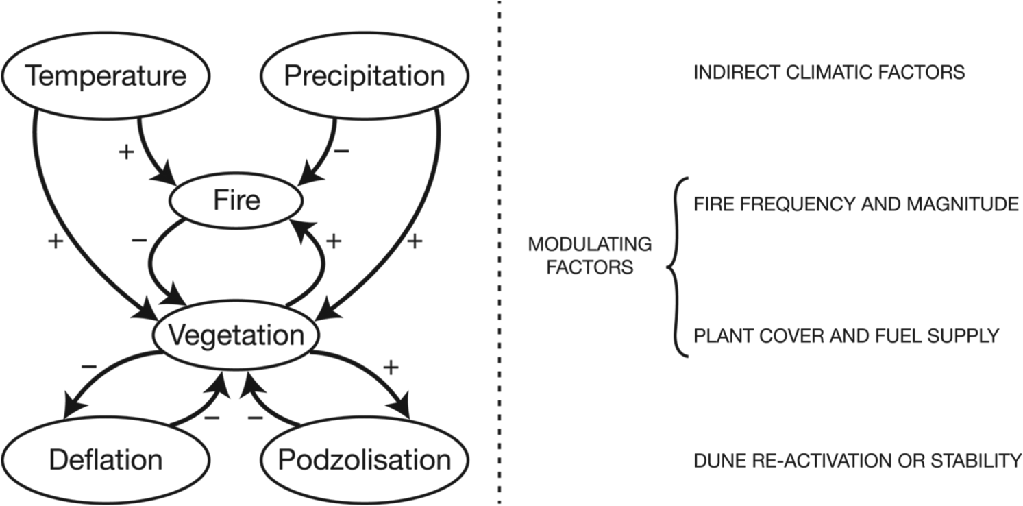
Schematic model of the main geo-ecological interactions affecting sand dune re-activation events and dune field landscape stability in Finnish Lapland.
Effects of the climatic factors are complex, and indirect effects are likely to be at least as important as the direct effects. The direct effect of an increase in temperature would be expected to increase the frequency of fire (e.g. by increasing the frequency of lightning strikes and drought), which is consistent with an overall monotonic increase in fire with temperature at the global scale (Daniau et al., 2012). The indirect effect of temperature in the dune fields of Finnish Lapland is likely to have been promotion of the severity of fires by increasing fuel availability, especially in the undergrowth, as a result of increased vegetation productivity and a longer growing season (cf. Krawchuk et al., 2009b; Westerling et al., 2006).
Similarly, a direct effect of an increase in precipitation would be to reduce fires by wetting fuel, a process that operates at the same time as the indirect promotion of fires by enhancing vegetation growth through enhanced soil moisture (e.g. Pitkänen et al., 2002; Whitlock, 2001). It is therefore no surprise that relationships between particular temperature and precipitation proxies and fire frequency are weak (as discussed in the previous section). This does not mean that temperature and precipitation are not influential factors, only that the indirect effects and interactions between particular processes can lead to variable outcomes that may appear ambiguous or contradictory.
Further complications arise from the operation of the various processes at varying scales in space and time. The phases of podzol development, for example, co-exist with late-Holocene dune re-activation events in dune fields where fires may create unstable patches in an otherwise stable landscape. More generally, fire and dune re-activation produce a highly heterogeneous landscape in which the elements of the mosaic vary in their relative proportions through time. During the Holocene, there appears to have been very little opportunity for the development of a uniformly stable dune landscape. The longest time interval of apparent stability was from 6500 to 5500 cal. BP, towards the end of the Holocene thermal maximum, when high temperatures and declining moisture were combined with extensive and high-density pine forest in Finnish Lapland. A lack of fires in the dune fields at this time may be accounted for by a less dense forest cover on the dunes relative to other habitats. Shorter intervals of relative stability, which were also associated with a low numbers of forest fires, occurred about 8300–7800, 5200–4800, 4600–3800, 3600–3100 and 2800–2400 cal. BP (Figure 6).
The human impact on vegetation and the dune fields of Finnish Lapland is generally considered to have been minor and not sufficient to have affected re-activation of sand dunes until the last 500 years, which saw the onset of semi-domesticated reindeer husbandry (Kotilainen, 1991, 2004; Seppälä, 1995). However, repeated anthropogenic use of fire is known to have been established by about 2000 years ago in northern Sweden initially to attract game and later to improve winter reindeer grazing (Hörnberg et al., 1999) and local effects of the use of fire by Palaeolithic and later people for hunting, cannot be ruled out (cf. Kotilainen, 2004; Tolonen, 1983).
Conclusion
The following conclusions are drawn:
Evidence from sand dune stratigraphy combined with a firm chronology based on radiocarbon-dated charcoal layers, supplemented by luminescence dating of sand, indicates a complex environmental history for the dune fields in subarctic Finnish Lapland. Our new data from four dune fields at Hietatievat, Kahilatievat, Pasmajärvi and Kuttanen significantly improve the available palaeoenvironmental record.
After deglaciation between 10,900 and 10,200 cal. BP, parabolic dunes, derived from extensive till, glaciofluvial and glaciolacustrine deposits, formed in a sparsely vegetated tundra landscape but were rapidly stabilised by vegetation (possibly within a few hundred years in favourable sites and up to about 2000 years in unfavourable sites).
The first sand dune re-activation event is radiocarbon dated to about 8300 cal. BP. However, the relatively low precision of luminescence dating, and the absence of charcoal layers prior to this time, means the existence of earlier re-activation events cannot be ruled out. The immigration of Scots pine (P. sylvestris) into Finnish Lapland, which occurred from about 9000 cal. BP, appears to have been the main reason for the first appearance of charcoal layers after that date.
Subsequently, on the basis of radiocarbon-dated charcoal layers, 15 further sand dune re-activation events occurred about 7500, 7200, 6600, 5200, 4600, 3900, 3600, 2800, 2100, 1800, 1500, 1200, 800, 500 and 100 cal. BP. Each re-activation event is inferred to have been triggered by one or more local fires that may have occurred up to 100–400 years after the date of each charcoal layer. Two factors account for this time lag: first, the charcoal has an inbuilt age (dependent on the age of the wood at the time the charcoal formed); second, charcoal may accumulate and/or recycle from earlier fires.
Sand dune re-activation events are indirectly related to centennial- to millennial-scale climatic variations, the effects of which are modulated by vegetation–fire interactions. Complex geo-ecological interactions account for weak associations detected between the re-activation events and Holocene climatic phases that are relatively cold and/or relatively wet in the Finnish subarctic environment. Cold intervals promoted deflation (aeolian erosion) by reducing the vegetation cover, while wet intervals promoted forest fires by increasing the biomass and hence fuel availability. However, other causal mechanisms are recognised.
Although forest fires were frequent throughout the Holocene, they were probably less frequent than in the boreal forest south of the treeline ecotone. The longest interval with an apparent very low number of fires in the dune fields was about 1000 years (6500–5500 cal. BP), towards the end of the Holocene thermal maximum, when high temperatures and declining moisture were combined with extensive and generally high-density pine forest in Lapland but forests may have been less dense in dune habitats. Shorter intervals of very low forest-fire frequency and hence relative stability of the dunes occurred about 8300–7800, 5200–4800, 4600–3800, 3600–3100 and 2800–2400 cal. BP.
Relatively long intervals of dune stability are indicated by well-developed buried iron podzols, which require 500–1000 years to develop. Four phases of podzol formation have been dated to the late Holocene based on maximum and minimum estimates of soil age from underlying and overlying charcoal layers, respectively, 1500–1050, 2300–1800, 3600–3000 and 4500–3900 calendar years BP. Earlier phases of podzolisation could not be defined because of insufficient evidence.
The results are explained using a conceptual geo-ecological model of the environmental factors affecting sand dune stability and instability in this subarctic environment. By emphasising the central role of vegetation–fire interaction and the indirect effects of temperature and precipitation on both dune re-activation and podzol development, the model provides a framework for understanding subarctic dune field landscape evolution and may help future predictions. A similar approach may well be applicable not only elsewhere in the subarctic but also in other types of aeolian landscapes at lower latitudes and in coastal environments.
Footnotes
Acknowledgements
The authors are also grateful to P Quentin Dresser who carried out the radiocarbon dating, to Manfred Frechen who supplied the luminescence dates, to Anna Ratcliffe for drawing up the figures for publication and to Stefan Doerr, Cristina Santín and Richard Shakesby for comments and advice. Accommodation at Hetta base camp during our field work was kindly provided by the Forest Research Institute of Finland.
Funding
The field work and age determinations were funded by the University of Helsinki in 1996 and by the Leverhulme Trust (grant RF&G/4/9800131 to JAM) in 1998 and 1999.