
Abstract
New pollen, phytolith, charcoal and diatom data from 14C AMS-dated sediments from three clusters of former occupation sites on the southern Yangtze Delta – Liangzhu, Majiabang and Chuodun – reveal that hydrological conditions were a key factor influencing early food production on the southern Yangtze Delta. At least two episodes of inundation are recognized, the first occurring at c. 7200–5700 cal. yr BP and a second from c. 4700 cal. yr BP. The first involved increasing salinity of surface waters, likely associated with marine intrusion linked to post-glacial sea-level change (meltwater pulse (MWP) 2). The second appears to have been freshwater in nature and driven at least in part by extreme meteorological events of high levels of precipitation in combination with impeded drainage. These two episodes had profound impacts on Neolithic settlement and farming. Further hydrological changes, presumably linked to changes in sedimentary regime, geomorphology and drainage of the Taihu depression, recorded at the Chuodun site after c. 3000 cal. yr BP, appear to have had a major effect on technologically relatively advanced food production systems. While environmental pressures appear to have played an important role in shaping human activities and settlement on the southern Yangtze Delta, people responded by adopting strategies that included an increased reliance on food production, migration to more clement locations and implementation of new technologies, which possibly included the construction of flood defence works.
Introduction
The lower Yangtze River was a focus for the emergence of early food production and civilization in what became China (Figure 1a; Qiu, 2008). Although early farming communities would have been dependent upon a broad-spectrum of nutritional sources (Fuller et al., 2010), rice became increasingly important during the early Neolithic (Zhao, 2010). A reliance on rice as a source of nutrition is likely to have commenced with the collection of wild ancestors of the domesticated form (Oryza sativa), such as the perennial Oryza rufipogon and annual Oryza nivara (Crawford and Chen, 1998; Nakamura, 2010; Vaughan et al., 2008). Climatic amelioration and associated changes to the water table during the late-Pleistocene and early-Holocene periods may have facilitated a range expansion of wild rice to the north from its glacial refugia in the tropics, with subsequent increases in temperature and humidity raising the productivity of rice-based food production systems (Nakamura, 2010; Sun et al., 2010; Wang et al., 2010) and resulting in agricultural surpluses that enabled diversification of society (Fuller and Qin, 2010).
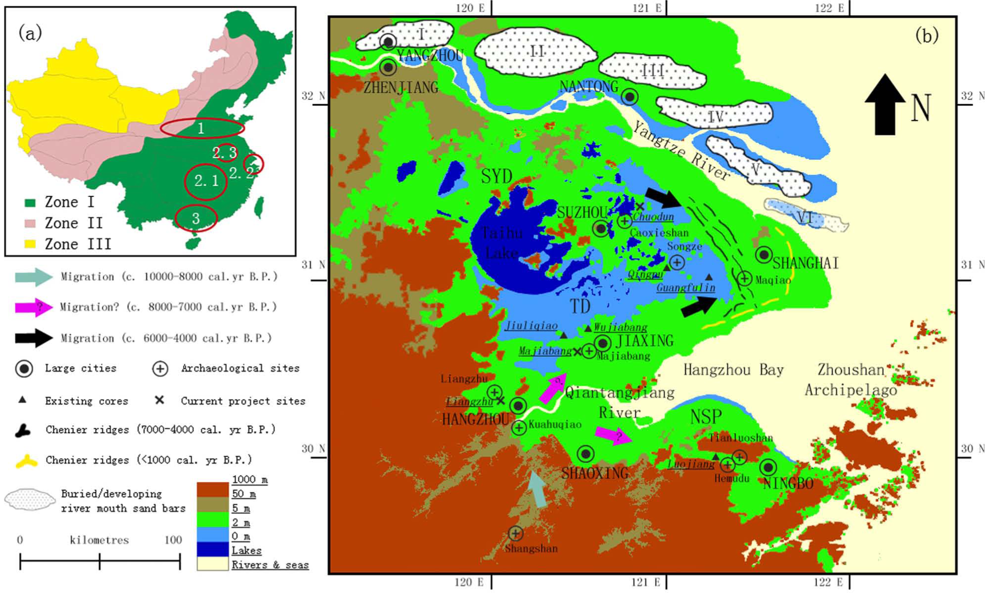
Location of the three current research sites and selected Neolithic Age–Bronze Age sites on the lower Yangtze. (a) Vegetation zones of continental China (Hainan and Taiwan Islands also illustrated on the map; modified from Map of Vegetation Regionalization of China in Liu (1998: 69)): Zone I is a humid/semi-humid forest zone, Zone II is a semi-arid steppe zone and Zone III is an arid desert zone. Major centres of early agriculture in China are shown (1: Yellow River Basin millet-based dry-land agriculture, 2.1: middle Yangtze rice-based agriculture, 2.2: lower Yangtze rice-based agriculture, 2.3: Huai River Basin rice-based agriculture, 3: Pearl River Basin tropical roots and tubers-based agriculture (Zhao, 2011)). (b) The lower Yangtze area: dashed lines are chenier ridges laid down during coastline progradation (Zhao, 1989), whereas river mouth sand bars of different ages constitute the centre of the Yangtze Delta (Li et al., 2000). Six distinct stages of sand bar development are recognized (Wang et al., 1981). Exiting sediment-based research sites can be found in Itzstein-Davey et al. (2007b) and Atahan et al. (2008) for Guangfulin, Hong (1989) and Zong et al. (2011) for Jiuliqiao, Itzstein-Davey et al. (2007a, 2007c) and Atahan et al. (2008) for Qingpu, Atahan et al. (2008) and Qin et al. (2011) for Luojiang and Qin et al. (2011) for Wujiabang. Selected archaeological sites and possible migration routes of early farmers are also shown.
Rising post-glacial sea levels led to the formation from c. 8000 yr BP (Hori et al., 2002) of a large delta in the lowermost reaches of the Yangtze River. The saucer-like Taihu depression is today a conspicuous feature of the southern Yangtze Delta (Figure 1b). Much of what is now the Taihu depression was a topographic high during the early Holocene, bounded by the channels of two palaeoestuaries to the south and north and dissected by their tributaries (Tao et al., 2006). Sedimentation in the two palaeoestuaries has gradually led to a reversal of topography and to the creation of the Taihu depression (Stanley and Chen, 1996), which received further protection from marine intrusion by chenier ridges and an accreting delta to the east since the late Holocene (Figure 1b; Zong et al., 2012b). Extensive freshwater wetlands formed in the depression (Tao et al., 2006), while a high connectivity to Hangzhou Bay to the south is thought to have facilitated the intrusion of saline water in its southwestern part prior to 6000 yr BP (Yan and Huang, 1987). Connections to Hangzhou Bay were weakened gradually throughout the mid-Holocene (Zong et al., 2011, 2012b). According to Wang et al. (2001), Lake Taihu formed c. 4600–3500 yr BP from rising inputs of freshwater and the coalescing of previously separate lakes. Lake Taihu has extended and contracted in extent since its formation, as inputs of water and sediment varied (Hong, 1991).
The southwestern part of the delta provided an entry point to early-Neolithic people who, combining foraging with cultivation, had moved down the Qiantangjiang River before traversing the wetlands bordering Hangzhou Bay, and then fanning out across alluvium forming the southern part of the proto-Yangtze Delta (Atahan et al., 2008; Jiang, 2006; Qin et al., 2011). Although conditions in the lower Yangtze may have favoured the onset and initial development of rice-based agriculture, there is now abundant evidence to suggest that early farmers and their crops were highly vulnerable to environmental vicissitudes during the early to mid-Holocene. The archaeological site at Kuahuqiao to the south of the Qiantangjiang River, for example, provides strong evidence that increased salinity c. 7500 cal. yr BP, associated with rising post-glacial sea level, led to an abrupt termination of rice-based agriculture (Zong et al., 2007). Furthermore, evidence from Tianluoshan, an archaeological site located some 80 km to the east of Kuahuqiao, indicates that the apparently catastrophic effects of increased salinity and inundation associated with marine intrusion on a food production system underpinned by rice could have been widespread during the early to mid-Holocene (Li et al., 2012; Zheng et al., 2012), at least in the area immediately to the south of the Yangtze Delta.
The current research examines new sedimentary evidence from three sites on the southern Yangtze Delta. The three sites, Liangzhu, Majiabang and Chuodun, are located along a transect running southwest to northeast, from close to the present-day northern bank of the Qiantangjiang River (Liangzhu) to the eastern part of the Taihu depression (Chuodun). Hydrological conditions were found as a key factor influencing early food production on the southern Yangtze Delta, just as they appear to have been south of the Qiantangjiang River and Hangzhou Bay.
Materials and methods
Study sites
This study is based on evidence generated from sediment samples recovered from three sites on the southern Yangtze Delta: Liangzhu, Majiabang and Chuodun. Supporting Information 1 (available online) briefly describes the three sites and summarizes published information for these sites. The sites were selected because of the range of environmental conditions they represent. Two of the sites (Liangzhu and Majiabang) have given their names to the two end members of three Neolithic cultural phases on the southern Yangtze Delta that are distinguishable from their associated material remains and that bracket, chronologically, the Songze (Atahan et al., 2008). The data from Majiabang presented here represent the only available radiometrically dated sedimentary evidence from the site.
Chronological frameworks
Age–depth relationships for the three sediment sequences were established based on characterization of lithostratigraphy and on radiometric (AMS 14C) dating of macro-charcoal or pollen residues (Table 1). A series of Poisson-process depositional models were used to incorporate data from these analyses, and also published sources of information (Table 2), into three chronological frameworks for the three sites. Details of how the frameworks were established are provided in Supporting Information 2 (available online).
AMS 14C dates on sediment samples taken from Liangzhu, Majiabang and Chuodun sites.
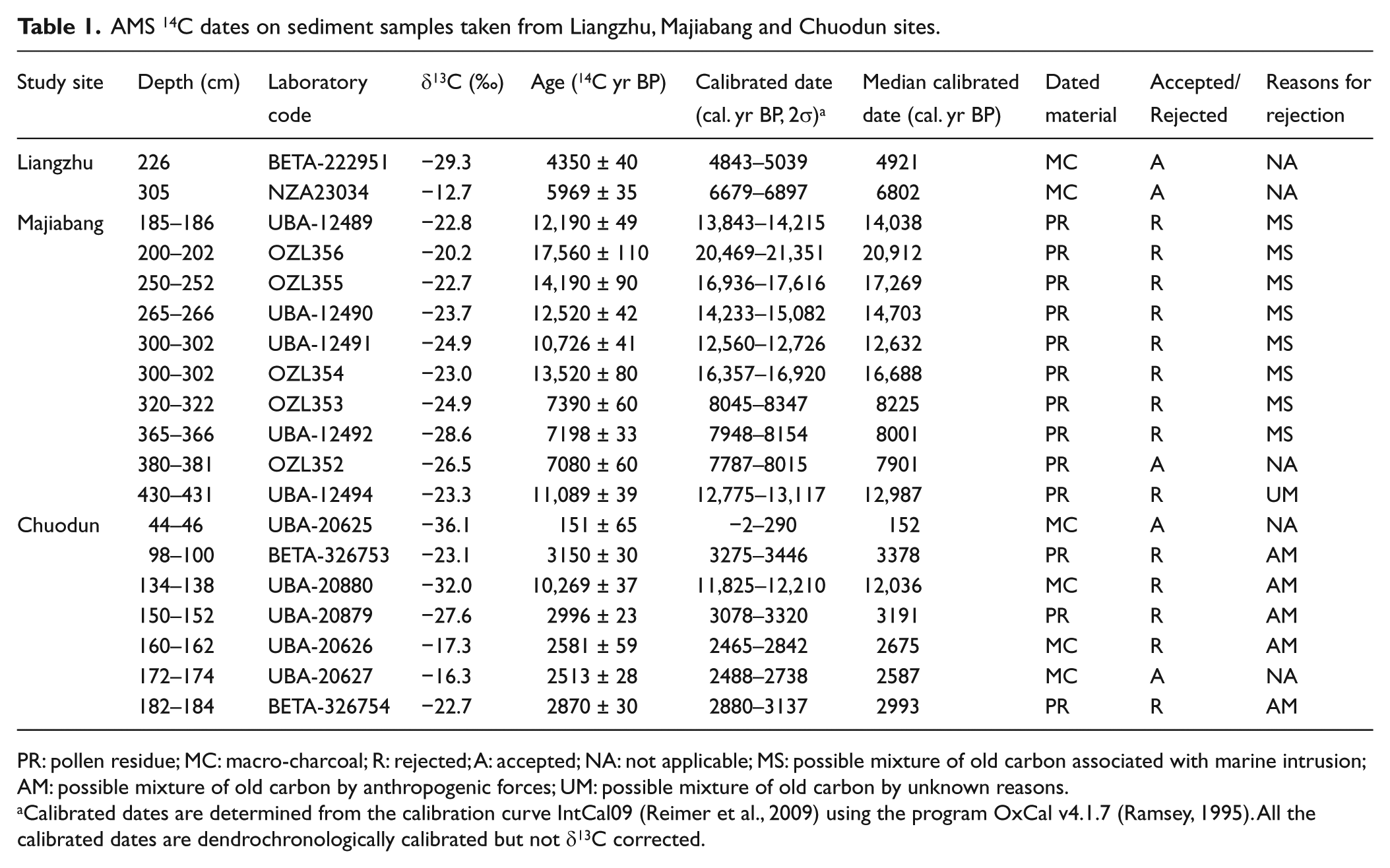
PR: pollen residue; MC: macro-charcoal; R: rejected; A: accepted; NA: not applicable; MS: possible mixture of old carbon associated with marine intrusion; AM: possible mixture of old carbon by anthropogenic forces; UM: possible mixture of old carbon by unknown reasons.
Calibrated dates are determined from the calibration curve IntCal09 (Reimer et al., 2009) using the program OxCal v4.1.7 (Ramsey, 1995). All the calibrated dates are dendrochronologically calibrated but not δ13C corrected.
Secondary AMS 14C data from existing references for refining geochronology of Liangzhu, Majiabang and Chuodun sites.
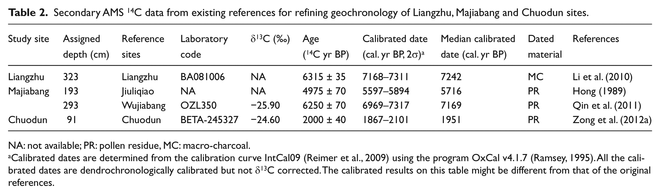
NA: not available; PR: pollen residue, MC: macro-charcoal.
Calibrated dates are determined from the calibration curve IntCal09 (Reimer et al., 2009) using the program OxCal v4.1.7 (Ramsey, 1995). All the calibrated dates are dendrochronologically calibrated but not δ13C corrected. The calibrated results on this table might be different from that of the original references.
Palaeoecological analyses
Sediment-based palaeoecological analyses were carried out in the current research following standard procedures, in order to reconstruct environmental history of the three study sites. The analytical techniques adopted are described in Supporting Information 3 (available online).
Results
Liangzhu
Sediment stratigraphy and AMS 14C chronology
The current research focused on a section of clay-rich sediments from between 490 and 135 cm in the 2500-cm-long core, the stratigraphy of which is illustrated in Figure 3. Chronological control relied primarily on two radiocarbon dates (Table 1). A third date from the Liangzhu site, cited in Li et al. (2010), was also used (Table 2 and Figure 2a). The latter dates a dramatic decrease in evergreen Quercus pollen and a sharp increase of Poaceae pollen that are present in both records from Liangzhu and possibly indicate intensification of human activities on or near the site.
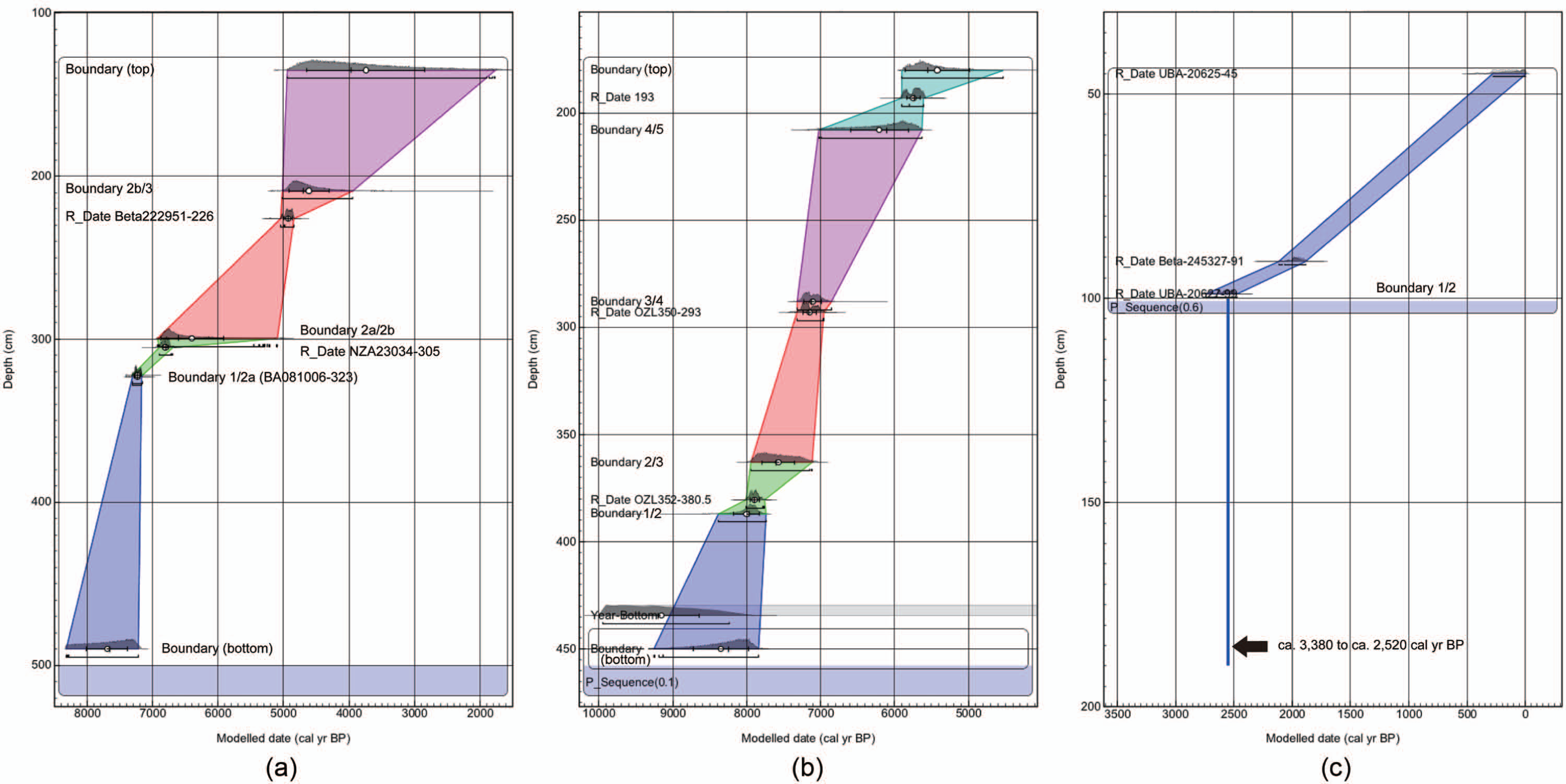
Age–depth models for the Liangzhu, Majiabang and Chuodun sites. A series of Poisson depositional models in OxCal v4.1.7 (Ramsey, 2008) were used to produce this plot. Age interval of each palaeoecological zone (Figures 3–5) of sediment sequences from the three sites is inferred from these models. (a) Liangzhu: geochronology reconstructed based on selected dates in the current research (Table 1) and in Li et al. (2010). (b) Majiabang: geochronology reconstructed based on selected dates in the current research (Table 1), in Hong (1989) and in Qin et al. (2011). (c) Chuodun: geochronology reconstructed based on selected dates in the current research (Table 1) and in Zong et al. (2012a).
Pollen, phytoliths and charcoal analysis
Up-core variations in pollen, charcoal and phytolith remains for sediments from Liangzhu analysed in the current research are illustrated in Figure 3. Three distinct zones were identified: LZ1 (490–323 cm, c. 7660–7230 cal. yr BP), LZ2 (323–209 cm, c. 7230–4700 cal. yr BP) and LZ3 (209–135 cm, c. 4700–3980 cal. yr BP). Zone LZ2 was subdivided further into LZ2a (323–299.5 cm, c. 7230–6600 cal. yr BP) and LZ2b (299.5–209 cm, c. 6600–4700 cal. yr BP).
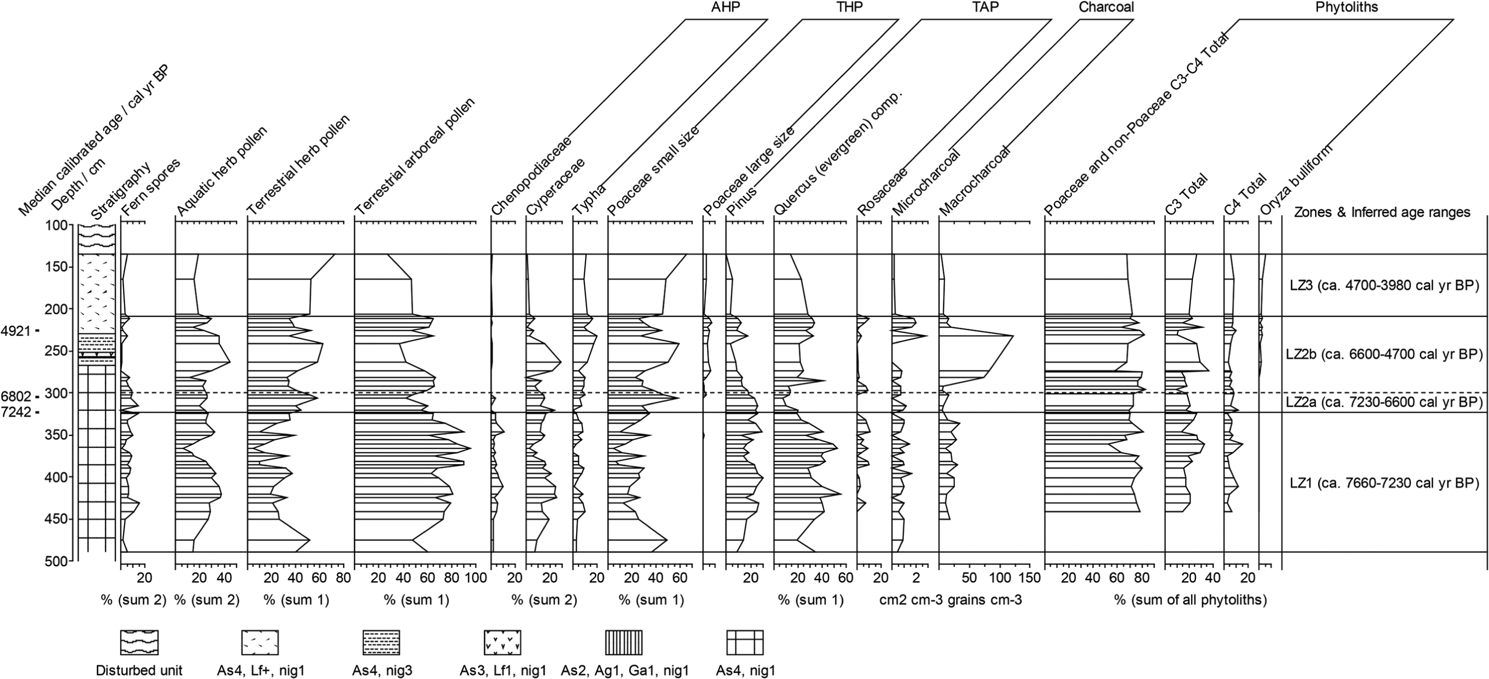
Summary of representative palynomorph (as percentages of different count sums), macro-charcoal (grains/cm3), micro-charcoal (cm2/cm3) and phytolith (as percentages of total sum of phytoliths) data from the Liangzhu site. Pollen data are grouped into three different categories: aquatic/(wetland) herb, terrestrial herb and arboreal pollen groups. Sum 1 is the sum of terrestrial herb and arboreal pollen, sum 2 is the total sum of all pollen and spores and sum 3 is the total sum of pollen and spores in addition to palynomorph algae. The stratigraphy is described according to Troels–Smith characterization system: 490–267 cm (clay-sized particles = c. 100%, darkness = close to white), 267–258 cm (clay-sized particles = c. 75%, non-hardened iron oxides = c. 25%, darkness = close to white), 258–257 cm (clay-sized particles = c. 50%, silt-sized particles = c. 25%, mineral particles sized from 2.0 to 0.06 mm = 25%, darkness = close to white), 257–252 cm (clay-sized particles = c. 75%, non-hardened iron oxides = c. 25%, darkness = close to white), 252–230 cm (clay-sized particles = c. 100%, darkness = close to black) and 230–135 cm (clay-sized particles = c. 100%, non-hardened iron oxides = traces, darkness = close to black) and 135–100 cm (disturbed unit). ‘Poaceae small size’ on the diagram represents Poaceae pollen equal or smaller than 40 µm, whereas ‘Poaceae large size’ represents Poaceae pollen larger than 40 µm.
Zone LZ1 is characterized by arboreal pollen from the taxa Pinus and evergreen Quercus, and to a lesser extent Carpinus, Castanopsis/Castanea, Juglans, Liquidambar and Ulmus. Poaceae (≤40 µm) is an abundant component of terrestrial herb pollen. Typha, Cyperaceae and Chenopodiaceae are the most common contributors to aquatic/(wetland) herb pollen. Percentages of phytoliths from Poaceae and non-Poaceae C3/C4 are relatively complacent throughout the zone, while the abundances of macro- and micro-charcoal remain largely stable.
Arboreal pollen in zone LZ2 is also characterized by evergreen Quercus, but Pinus pollen abundances are lower compared with LZ1. Poaceae pollen ≤40 µm remains abundant, while the large-sized category (>40 µm) is also represented. The abundance of Chenopodiaceae decreases, whereas the percentages of Typha increase. Phytoliths from C3 and C4 grasses are abundant, and phytoliths from the domesticated form of Oryza are present. Subzone LZ2b is marked by large peaks in macro- and micro-charcoal concentrations and increasing abundances of Poaceae (>40 µm) when compared with LZ2a. LZ2a is characterized by a substantial fall in the amount of pollen from evergreen Quercus and Rosaceae, and by a sharp peak in Poaceae (≤40 µm). LZ3 is marked by decreases in both macro- and micro-charcoal abundances, in addition to Poaceae (>40 µm), and by increases in Poaceae (≤40 µm).
Majiabang
Sediment stratigraphy and AMS 14C chronology
Sediments below 800 cm in the core from Majiabang comprise the first stiff clay layer unit (stratigraphy in Figure 4), a widespread deposit dating to the late Pleistocene (Qin et al., 2008). There is thus a high certainty that the sediments analysed from the site as part of the current research – a section rich in microfossils from 450.5 to 180.5 cm – accumulated post c. 10,000 cal. yr BP. Confirmation of this, based on AMS 14C dating of macro-charcoal and pollen residues extracted from core sediments, has proven problematic (Table 1): seven seemingly anomalous dates are associated with samples of sediment from c. 300 to c. 185 cm. Problems in dating of deltaic material are not uncommon, including sediments from the Yangtze Delta (Stanley and Chen, 2000). In the current research, remobilization and redeposition of sediments could have led to carbon of different ages being mixed. Only the date (7080 ± 60 14C yr BP for 381–380 cm) from those available appears valid and was therefore included in the age–depth sedimentation model upon which chronological control is based.
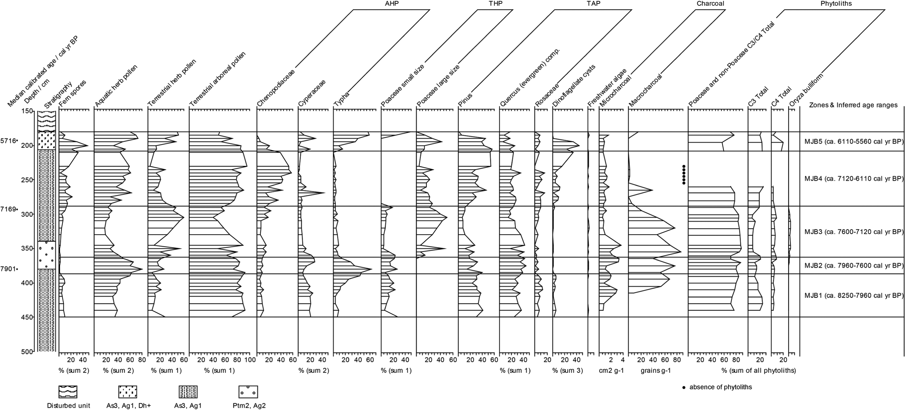
Summary of representative palynomorph (as percentages of different count sums), macro-charcoal (grains/g), micro-charcoal (cm2/g) and phytolith (as percentages of total sum of phytoliths) data from the Majiabang site. Pollen data are grouped into three different categories: aquatic/(wetland) herb; terrestrial herb and arboreal pollen groups. Sum 1 is the sum of terrestrial herb and arboreal pollen, sum 2 is the total sum of all pollen and spores and sum 3 is the total sum of pollen and spores in addition to palynomorph algae. The stratigraphy is described according to Troels–Smith characterization system: 500–380 cm (clay-sized particles = c. 75%, silt-sized particles = c. 25%); 380–340 cm (fragments of calcareous shells = c. 50%, silt-sized particles = c. 50%); 340–206 cm (clay-sized particles = c. 75%, silt-sized particles = c. 25%); 206–180 cm (clay-sized particles = c. 75%, silt-sized particles = c. 25%, fragments of herbaceous plants >2 mm = traces) and 180–150 cm (disturbed unit). ‘Poaceae small size’ on the diagram represents Poaceae pollen equal or smaller than 40 µm, whereas ‘Poaceae large size’ represents Poaceae pollen larger than 40 µm.
There is less than 20 km between Majiabang and a site with recently published data, Wujiabang (Qin et al., 2011). An extensive marine incursion during the early to mid-Holocene is likely to have influenced these two sites around the same time, given their proximity and similarly low elevation (c. 2 m a.m.s.l. of Wujiabang; c. 1.8 m a.m.s.l. of Majiabang). A third site adjacent to Majiabang, Jiuliqiao, also records a gradual lowering of salinity following a marine intrusion (Hong, 1989; Zong et al., 2011). Based on stratigraphic correlation of a variety of sedimentary components, radiocarbon dates from Wujiabang and Jiuliqiao (Table 2) were incorporated into the Majiabang geochronology using the Poisson-process depositional model in OxCal, in addition to the accepted date in the current research (Table 1). Results suggest that the onset and end of this marine influence at Majiabang, where it is marked by a peak of dinoflagellate remains, were at, respectively, c. 7160 and c. 5730 cal. yr BP (Figure 2b).
Pollen, phytoliths and charcoal analysis
Up-core variations in pollen and charcoal data and phytolith remains for sediments from the Majiabang site are illustrated on Figure 4. Five palaeoecological zones were identified: MJB1 (450.5–387 cm, c. 8250–7960 cal. yr BP), MJB2 (387–363 cm, c. 7960–7600 cal. yr BP), MJB3 (363–288 cm, c. 7600–7120 cal. yr BP), MJB4 (288–208 cm, c. 7120–6110 cal. yr BP) and MJB5 (208–180 cm, c. 6110–5560 cal. yr BP).
MJB1 is characterized by the high abundance of pollen from both arboreal and non-arboreal taxa. Of the arboreal pollen, Pinus and evergreen Quercus are dominant, followed by Rosaceae, Betula, Carpinus, Castanopsis/Castanea, Juglans and Liquidambar. Terrestrial herb pollen is dominated by Poaceae (≤40 µm). Typha, Cyperaceae and Chenopodiaceae are the most common contributors to aquatic/(wetland) herb pollen. Dinoflagellate cysts have a low abundance. Phytoliths from Poaceae and non-Poaceae C3/C4 dominate, while concentrations of macro- and micro-charcoal are relatively high.
MJB2 differs from the adjacent zones by a sharp increase of Typha pollen. The remains of freshwater algae (Concentricystes spp. and Zygnemataceae) are present. Other pollen taxa, phytoliths and macro- and micro-charcoal concentrations remain at similar levels to zone MJB1. Dinoflagellate cysts are virtually absent.
MJB3 is distinguished by high percentages of Poaceae (>40 µm) and the presence of phytoliths from a domesticated form of Oryza. The abundance of evergreen Quercus is also high, whereas percentages of Pinus are lower, as are levels of Typha pollen. Concentricystes spp. are the most common freshwater algae, whereas Dinoflagellate cysts remain in low abundance. Concentrations of macro- and micro-charcoal remain high.
MJB4 is marked by a rapid increase in Chenopodiaceae pollen and dinoflagellate cysts. Pinus pollen also increases, while evergreen Quercus declines. Poaceae (>40 µm) decreases sharply; phytoliths are absent from the upper part of this zone. Concentrations of macro-charcoal decrease; however, micro-charcoal concentrations remain largely similar to those of underlying zones.
MJB5 is characterized by increasing abundance of Typha pollen. Arboreal pollen is present in lower abundances compared with MJB4. Dinoflagellate cysts decrease and eventually disappear towards the top of the zone. Levels of macro-charcoal are low, while the abundance of micro-charcoal is comparable with MJB4.
Chuodun
Sediment stratigraphy and AMS 14C chronology
Radiocarbon dates for the Chuodun site are also problematic. Not only do five radiocarbon dates between 190 and 98 cm (stratigraphy on Figure 5) show a similar age from c. 3380 to 2590 cal. yr BP (Table 1), but major age reversals also occur, including an anomalously old date (11,825–12,210 cal. yr BP (2σ)) at the depth of 138–134 cm, which presumably reflect old carbon effects. The sediment section between 190 and 99 cm is likely to have been disturbed by human activities (e.g. agriculture). This is because there is evidence, in the form of what has been claimed to be an ancient system of paddy fields dating to the mid-Holocene (Ding, 2010; Hu et al., 2013), for a sustained period of human occupation at or close to the current sample site (Cao et al., 2006; Zong et al., 2012a). The most parsimonious interpretation of the radiocarbon dates, in the context of the location of the sediment profile, is that the section 190–99 cm has an approximate age of c. 3000 cal. yr BP, and a minimum age of 2513 ± 28 14C yr BP. The latter date was also used in the Poisson-process depositional model in order to establish chronological control, together with the date 151 ± 65 14C yr BP at 46–44 cm and a date from the same site published in Zong et al. (2012a; Figure 2c).

Summary of representative palynomorph (as percentages of different count sums), macro-charcoal (grains/cm3), phytolith (as percentages of total sum of phytoliths), sponge spicule and diatom (as percentages of total sum of diatoms) data from the Chuodun site. Pollen data are grouped into three different categories: aquatic/(wetland) herb; terrestrial herb and arboreal pollen groups. Sum 1 is the sum of terrestrial herb and arboreal pollen, sum 2 is the total sum of all pollen and spores and sum 3 is the total sum of pollen and spores in addition to palynomorph algae. The stratigraphy is described according to Troels–Smith characterization system: 190–106 cm (silt-sized particles = c. 50%, clay-sized particles = c. 50%, mineral particles sized from 2.0 to 0.06 mm = traces, charcoal = traces), 106–102 cm (clay-sized particles = c. 75%, silt-sized particles = c. 25%, charcoal = traces), 102–84 cm (silt-sized particles = c. 50%, clay-sized particles = c. 50%), 84–52 cm (silt-sized particles = c. 75%, clay-sized particles = c. 25%, non-hardened iron oxides = traces, fragments of ligneous plants >2 mm = traces) and 52–44 cm (disturbed unit). ‘Poaceae small size’ on the diagram represents Poaceae pollen equal or smaller than 40 µm, whereas ‘Poaceae large size’ represents Poaceae pollen larger than 40 µm.
Pollen, phytoliths, charcoal and diatoms analysis
Variations in pollen and charcoal data, phytolith remains and diatom records for sediments from Chuodun are illustrated in Figure 5. Two distinct palaeoecological zones were identified: CD1 (190–99 cm, c. 3380–2520 cal. yr BP) and CD2 (99–44 cm, c. 2520–90 cal. yr BP).
CD1 is characterized by terrestrial herb pollen, with Poaceae (>40 µm) abundant throughout. Commonly represented arboreal taxa include evergreen Quercus, Moraceae, Rosaceae, Carpinus and Castanopsis/Castanea, while Pinus and Salix are present but in low percentages. Cyperaceae, Typha and Potamogetonaceae, in addition to Chenopodiaceae, are the most abundant aquatic/(wetland) herb taxa. High concentrations of macro- and micro-charcoal, as well as domesticated forms of Oryza phytoliths, also characterize CD1. Freshwater diatoms are also abundant, although marine/saline taxa occur sporadically.
Major shifts in microfossil composition are evident across the CD1–CD2 boundary; pollen from arboreal taxa decreases while that from aquatic/(wetland) herbs increases. Pollen from Rosaceae, Moraceae and evergreen Quercus declines in CD2. By contrast, Pinus and Salix are most abundantly represented among arboreal taxa. Poaceae pollen continues to be the most abundant among the terrestrial herbs, although the abundance of grains in the large size category (>40 µm) is lower than in CD1. Chenopodiaceae pollen declines gradually, while pollen from Potamogetonaceae increases. Levels of macro- and micro-charcoal, as well as Oryza phytoliths, are all in low abundance throughout CD2, in particular double-peak Oryza glume cells (phytoliths). Notably, diatoms are absent in CD2, while sponge spicules are abundant.
Discussion
Palaeoecological data from Liangzhu, Majiabang and Chuodun suggest that hydrological change was a key factor affecting settlement/food production of prehistoric societies on the southern Yangtze Delta.
Marine intrusion and settlements in early-Neolithic Period (c. 7200–5700 cal. yr BP)
The Liangzhu site is close to the southernmost boundary of the Yangtze Delta. Although located close to a possible entry point for early farmers wishing to access the accreting deltaic plain in the early Holocene, there is little microfossil evidence of occupation or food production at Liangzhu prior to 6600 cal. yr BP. Archaeological remains at Liangzhu are scattered over an extensive area of comparatively (in the context of the southern Yangtze Delta) undulating topography and situated close to land of relatively high altitude to the west, where extensive subtropical forests could have provided additional resources to early settlers. Existing archaeological evidence suggests that relatively low-lying sites, such as Kuahuqiao (Zong et al., 2007) and Majiabang, when compared with Liangzhu, were probably more attractive to early-Neolithic communities as settlement sites, perhaps because of their close proximity to abundant wetland resources (Crawford, 2012; Pan, 2011). The first farmers may therefore have preferentially avoided raised and undulating parts of the southern delta, such as Liangzhu, in their search for suitable sites to occupy on a relatively permanent basis.
Reduced salinity at Majiabang from c. 8000 cal. yr BP, marked by a reduced abundance of dinoflagellate remains and an increased abundance of Typha pollen in sediments dating to this time, appears to have been associated with increased human activities in the vicinity, as indicated by an abrupt rise in macro-charcoal concentrations. There is little evidence, however, from the sediments that these activities were associated with food production. According to the microfossil record, freshwater conditions peaked between c. 7960 and 7600 cal. yr BP. However, rice does not appear to have become important at the site until after c. 7600 cal. yr BP, and perhaps only once freshwater conditions began to recede and the availability of natural wetland resources – and thus food security based on hunting and gathering – had declined sufficiently.
The period of freshwater conditions, between c. 7600 and 7120 cal. yr BP, was associated at Majiabang with the production of rice and appears to have been curtailed by increased salinity. An abrupt eustatic sea-level rise, believed to have been linked to a release of glacier meltwater (meltwater pulse (MWP) 2; e.g. Bird et al., 2007) and dated c. 7600 cal. yr BP (Lambeck et al., 2010), could have been responsible for an influx of saline waters and the disruption of food production at Majiabang. The deposition of sediments with marine facies dating to c. 7500–7000 cal. yr BP in the lower Yangtze (Ding, 2004; Li and Fan, 2009) could also relate to an abrupt rise in sea level, with any lag between the original MWP and its effects on a product of local environmental conditions (Milne and Shennan, 2007). Microfossil evidence indicates that the site at Majiabang was reoccupied following the recovery of freshwater conditions at c. 6110 cal. yr BP, likely associated with a relatively stable sea level (Chen et al., 2008; Wang et al., 2012); however, frequent marine inundation persisted until c. 5700 cal. yr BP.
People may have abandoned occupation sites at relatively low altitudes such as Majiabang (Figure 4) for raised, better drained areas of ground where problems of flooding were less severe. Thus, despite being previously avoided, sites that were slightly raised in altitude above the level of the delta plain, such as Liangzhu, may have become more attractive locations for Neolithic farmers and their associated settlements, displaced from lower-lying parts by the intrusion of saline waters. Changes in the sedimentary record at Liangzhu show intensified modification of the environment and the appearance of rice-based agriculture from c. 6600 cal. yr BP.
Climatic change and settlements in late Neolithic Period (from c. 4700 cal. yr BP to ?)
Food production at Liangzhu appears, on the basis of the sedimentary evidence, to have largely ceased from c. 4700 cal. yr BP. The cause of this disruption is not clear from the sedimentary record because of the relatively poor preservation of some microfossils after this date. A clue to the cause of this decline may, however, be found in archaeological evidence. Approximately 1 km to the northwest of the cluster of archaeological sites are the remains of large, linear earthworks, more than 4 km long and 3–5 m high (Zhang, 2003; Zhang and Wu, 2007). These earthworks, dated to the Liangzhu Period, have been interpreted as a flood defence structure, aimed at protecting the occupants of Liangzhu and their property from floods originating in the highlands to the north (Zhang, 2003). The occupants of Liangzhu may therefore have faced the risk of severe flooding, to the extent that they were prepared to invest heavily in, and cooperate in the building of, major flood defence works.
A range of evidence indicates that the period of decline of the Liangzhu culture was accompanied by alterations in hydrological conditions on the southern Yangtze Delta. Dated remains of wood preserved in palaeoflood deposits in the highland areas that ring the western boundary of the southern Yangtze Delta, for example, indicate that the period c. 4600–4000 cal. yr BP was associated with a relatively high frequency of torrential floods (Yu et al., 2003). In addition, frequent palaeofloods in the later stages of the Liangzhu Period are reported elsewhere in the lower Yangtze (e.g. Shi et al., 2008; Stanley et al., 1999). However, palaeoclimatic data suggest that the period between c. 4600 and 4000 cal. yr BP in eastern China was, overall, marked by reduced – rather than increased – levels of rainfall, along with cooling (Tao et al., 2006; Yi et al., 2003) in association with a weakened summer monsoon (Dong et al., 2010) as the monsoonal front retreated southwards (An et al., 2000). The flooding that appears to have impacted Liangzhu so severely during this period was thus possibly a result of an increased frequency of extreme meteorological events, rather than the consequence of an overall increase in annual precipitation (cf. Wu and Liu, 2004). Furthermore, the formation of Lake Taihu – now the third largest body of freshwater in China (Sun and Mao, 2008) – at c. 4600–3500 yr BP (Wang et al., 2001) was one manifestation of the profound hydrological changes impacting the southern Yangtze Delta during the mid- to late Holocene. Impeded drainage owing to an accumulation of sediments in the network of channels draining the southern delta in combination with rising sea level would have increased the risk of severe flooding during heavy rains.
Further hydrological changes and settlements (after c. 3000 cal. yr BP)
As is evident from the Chuodun data presented here, and from existing sedimentary data from elsewhere in the lower Yangtze (Atahan et al., 2008; Itzstein-Davey et al., 2007a), food production in which the cultivation of domesticated forms of rice was an important component was widespread by the Bronze Age (Maqiao)–Iron Age (Zhou Dynasty) transition, c. 3000 cal. yr BP (Wang et al., 2010). The similar radiocarbon dates (from 3150 ± 30 to 2513 ± 28 14C yr BP; Table 1) between the depths of 190 and 99 cm for the sediments from the exposed profile at Chuodun may reflect a more thorough disturbance of sediments by farmers using improved technologies than was previously possible. The existence of abundant diatoms and Oryza phytoliths also points to the possibility that this sediment section was retrieved from an ancient paddy field, where low energy and relatively quiescent aquatic conditions would have favoured the preservation of diatom remains. In addition, high percentages (at least 88%) of double-peaked Oryza glume phytoliths throughout the late Holocene–aged sediments from Chuodun indicate a strong reliance locally on domesticated forms of rice, while the abundant presence of Moraceae pollen, potentially from Cannabis sativa and/or Morus alba (Yu, 2010), may represent the cultivation of plants used to produce textiles such as hemp and therefore a diversified agricultural economic base.
Increasingly coarser sediments in the sampled profile from Chuodun (Figure 5) possibly reflect the development of higher energy aquatic conditions, post c. 3000 cal. yr BP, and may have been due to further expansion of water bodies on the Taihu depression after the formation of Lake Taihu. In accordance with relatively stable sea level locally over the last c. 3000 years (Zong, 2004), a reduced marine influence is evident at Chuodun in the form of a gradual decrease in Chenopodiaceae pollen.
The sedimentation rate of the Yangtze Delta is thought to have increased gradually during the mid- to late Holocene, particularly since c. 2000 cal. yr BP, largely because of a rise in sediment production associated with widespread human activities and to decreased levels of deposition in the middle reaches of the Yangtze River (Hori et al., 2001). Large proportions of these sediments were deposited on the periphery of the Taihu depression, creating the now distinctive saucer-like landscape from what was previously an overtuned bowl-like, topographical high (Chen et al., 1997). This topographical reversal, in turn, led to further impeded drainage and to more frequent inundation, mostly freshwater in origin (Chen et al., 1997). As a result, the extent of standing water bodies and saturated ground generally in the Taihu depression increased (Shi and Zhu, 2004), including several episodes of major expansion of the existing Lake Taihu since c. 4600–3500 yr BP, as documented in historical archives (Hong, 1991).
An increase of aquatic/(wetland) pollen in zone CD2 (c. 2520–90 cal. yr BP), notably Potamogetonaceae, could represent further development of more lacustrine-like conditions at Chuodun. Members of the Potamogetonaceae are largely aquatics, associated with relatively quiescent freshwater bodies (Editorial Board of ‘Flora of Zhejiang’, 1993). Similarly, changes in arboreal pollen, notably an increase in Salix (a taxon that is often found in close association with moist edaphic conditions, e.g. Salix babylonica L.; Wang and Gao, 2006), and more abundant sponge spicules would also appear to indicate, edaphically at least, increasingly moist conditions. These changes coincide with decreasing Oryza phytoliths, Poaceae pollen (>40 µm) and Moraceae pollen, as well as macro- and micro-charcoal remains. The microfossil evidence therefore suggests an abandonment of the site since the Eastern Zhou Dynasty (2720–2171 cal. yr BP), possibly as a result of increasing edaphic wetness in general or an increased frequency of inundation, and this receives support from the archaeological record. Very few archaeological remains on the site date to be period from 2171 (onset of the Qin Dynasty) to 1332 cal. yr BP (termination of the Sui Dynasty; Suzhou Museum, Kunshan Cultural Relic Manage Committee and Zhengyi Township Government of Kunshan City, 2003). Thus, even at this relatively late stage of technological advancement on the deltaic plain, when societies can be expected to have possessed far more advanced technologies than their Majiabang and Liangzhu ancestors, the scope of human activities appears to have remained constrained by hydrological conditions. The earthworks at Liangzhu may represent an early attempt to control flood waters. Moreover, hydraulic engineering is documented to have been practised as early as the Bronze-Age Shang Dynasty (c. 3550–2996 cal. yr BP; Huang and Zhu, 2004). However, the systematic construction of large hydraulic projects (e.g. Hai Tang (embankment along the coast) and Hu Di (embankment along the Taihu Lake bank)) did not take place until the Tang Dynasty (1332–1043 cal. yr BP; Huang and Zhu, 2004). Such drainage and flood protection schemes had the additional benefit of converting the river channels and lakes into a more efficient transport network, thereby boosting trade within the delta and with other parts of China and the region more widely (Lu et al., 1998). Thus, Holocene environmental conditions on the southern delta, particularly hydrology, have acted at different times as both a constraint and an impetus to food production, settlement and economic activities (Figure 6).
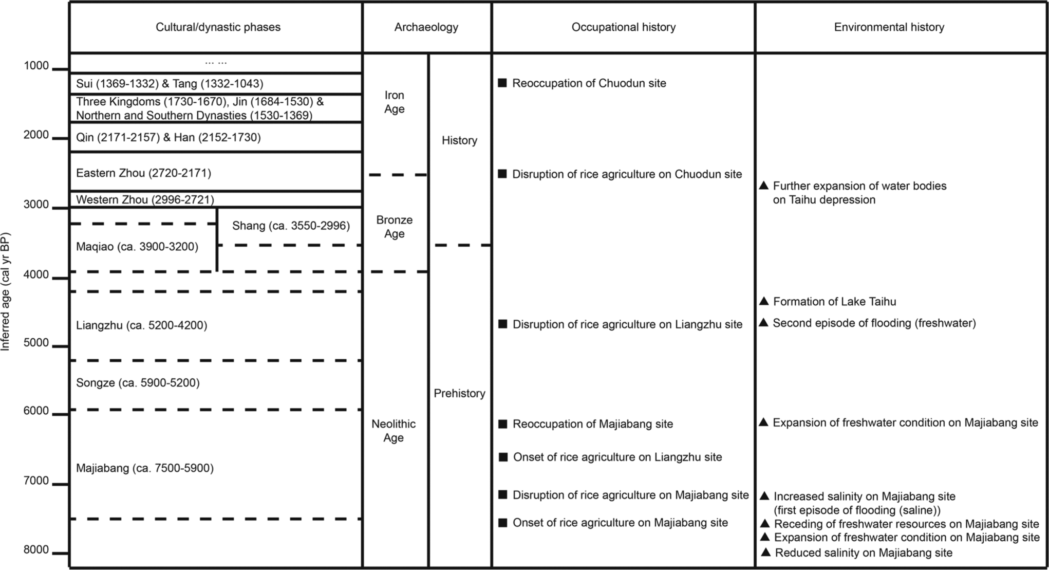
Synthesized environmental history of the southern Yangtze Delta.
Conclusion
Sediment-based palaeoecological data from three sites on the southern Yangtze Delta, in the context of existing research, demonstrate the importance of hydrological change in influencing early food production and associated human societies and their settlements. Two episodes of inundation in the first instance linked with sea-level change in the early Holocene and in the second with extreme meteorological events during a period of mid- to late-Holocene climate change are recognized in evidence presented here. Hydrological change also appears to have exerted some influence over the choice of settlement location and food production strategies. Generally, people can be expected to respond to environmental challenges through adopting new technologies – intensifying rice production and investing in hydraulic engineering, for example – provided that environmental pressures, or their effects, remain manageable. When environmental pressures overwhelm local capacities, people may be forced to respond accordingly and to move their settlements and livelihoods to more secure locations. Thus, the challenge and response (Von Der Muhll, 2007) combination in relation to hydrological pressures on the southern Yangtze Delta was not straightforward in the past and reflects the complexity of interactions among prehistoric societies, their access to technology and the nature, magnitude and presumably rate of Holocene environmental changes.
Footnotes
Acknowledgements
Particular thanks are due to Hongbo Zheng and Bin Zhou of Nanjing University for their warm hospitality and for their assistance at all stages in the work. Thanks are also due to Guoxuan Wu, Xiangtong Huang and Shifan Xu of Tongji University; Wei Ming Wang of Nanjing Institute of Geology and Palaeontology and Xueqing Hong and Baocheng Zhao of East China Normal University, for their advice and assistance in fieldwork. The first author (TL) thanks Yongqiang Zong of the University of Hong Kong for providing training on diatom identification and interpretation. Thanks are also due to John Dodson of Australian Nuclear Science and Technology Organisation for assistance with 14C AMS dates, and to the very constructive comments from Robin Edwards of Trinity College Dublin and to two anonymous reviewers of an earlier version of this manuscript.
Funding
This received financial support from the Irish Research Council, Chinese Academy of Sciences (CAS) Strategic Priority Research Program Grant XDA05130502 and RIA/QUB Radiocarbon Dates Scheme 2012.