
Abstract
Temperate Highland Peat Swamps on Sandstone (THPSS) are a form of topogenous mire found on the plateau areas of eastern Australia. They are well recognised for their ecological value, but our understanding of their geomorphic structure, function and evolution remains limited. Across 19 sites, the valley fills of THPSS comprise sequences of mineral-rich sand and loam deposits. Basal sand and gravel sediments have low organic content and low carbon to nitrogen (C:N) ratios (a measure of peat formation) and are dated between 15.3 and 9 kyr cal. BP, with outliers back to 44 kyr cal. BP. These units reflect mineral-sediment trapping and accumulation on the valley floor. The transition to ‘swamp’ conditions through paludification occurred between 15.2 and 10.3 kyr cal. BP in some systems, and between 7.6 and 1.4 kyr cal. BP in other, adjacent valleys. These ‘swamp’ sediments comprise a package of units, progressing upward from fine cohesive sands, through assemblages of alternating organic sands to surface organic fines. These beds vary in texture from loams to sands and have a range of organic matter content (from 7.6% to 79.9%) and C:N ratios (from 15 to 58). The surface organic fines at 0 and 100 cm depth range in age from 13.1 to 0.7 kyr cal. BP. The composition and age structure of the valley fill suggest a mix of allogenic and autogenic controls are responsible for the formation of these swamps, but a regional model of THPSS evolution is emerging. Given these ‘peatlands’ have formed under a climate that experiences significant inter-annual variability in rainfall, conditions for peat formation are localised and not directly equivalent to those documented internationally.
Introduction
Temperate Highland Peat Swamps on Sandstone (THPSS) are a distinctive feature of low-relief plateaus in eastern Australia (Dodson et al., 1994; Fryirs et al., 2014; Young, 1986a; Young and Young, 1988). Using the classification of Charman (2002) and Evans and Warburton (2007), these systems are valley mire fens.
THPSS are listed as an endangered ecological community under the Environment Protection and Biodiversity Conservation Act 1999 (Cwlth) and the Threatened Species Conservation Act 1995 (New South Wales (NSW)). The Blue Mountains and Southern Highlands of NSW, where THPSS are concentrated, reside within the water supply catchment for Australia’s largest city, Sydney, and play a key role in determining the quantity and quality of water in these catchments (Fryirs et al., 2014). Despite playing a vital role in water supply and their ecological significance, they are threatened by activities such as long wall mining, coal seam gas extraction and catchment urbanisation (Department of Environment and Climate Change (DECC), 2011; Hensen and Mahony, 2010; Kohlhagen et al., 2013).
In eastern Australia, upland swamps (including THPSS) were more prevalent at the time of European settlement than at present (Bell et al., 2005; Buchanan, 1979; Burrough et al., 1977; Holland et al., 1992; Pemberton, 2005; Prosser and Melville, 1988; Young and Young, 1988). As is the case internationally, many swamps have been drained or channelised as a result of agricultural activity and urban sprawl (Evans and Warburton, 2007; Fenner et al., 2011; Gebhardt et al., 2010; Kohlhagen et al., 2013; Moore, 2002; Robarts et al., 2013). Few examples of ‘intact’ swamps remain outside protected areas. Recent recognition of the value of these systems has prompted policy that places priority on the conservation and maintenance of intact swamps, and reinstatement of swamps where they have been degraded or destroyed (Kohlhagen et al., 2013). However, despite their importance in terms of water supply and biodiversity, the geomorphic structure, function and timescales of adjustment of these systems have not been adequately investigated or quantified (Pemberton, 2005). Consequently, conservation and rehabilitation planning as part of Catchment Action Plans and National Water Initiatives is occurring in the absence of such understanding. It is timely that THPSS are understood and recognised as an integral part of the catchment water cycle.
For several decades, a very simple model of THPSS formation based on isolated case studies has permeated the literature (Prosser and Melville, 1988; Young, 1986a). In this model, THPSS occur on the plateau above the escarpment of the Great Dividing Range between 500 and 1200 m above sea level (a.s.l.), in areas of rainfall > 1200 mm/yr. In these headwater settings, sandy, mineral sediment is trapped and accretes along the drainage lines of shallow valley floors (Fryirs et al., 2014; Tomkins and Humphreys, 2006). Gentle valley gradient produces low stream energy and stream channels are poorly defined, creating an unchannelised valley floor that may contain discontinuous channels or ponds. Subsequent accumulation of organic matter and waterlogging result in swamp formation. What is not examined as part of the prevailing model is the peat-forming potential of these systems.
Most peatlands in the northern hemisphere developed during the Holocene since the last glaciation (Gorham and Rochefort, 2003). Their structure, function and peat-forming characteristics have been widely reported (e.g. Huang et al., 2013; Lavoie et al., 2013; Rundgren, 2008; Ruppel et al., 2013; Van der Knaap et al., 2011). However, little work has been conducted in the southern hemisphere on temperate peatlands that have formed in non-glaciated landscapes (Pemberton, 2005; Whinam et al., 2003).
Peat formation is a key component of mire functionality and has been widely documented internationally (Evans and Warburton, 2007; Gorham and Rochefort, 2003; Huang et al., 2013; Lavoie et al., 2013; Rundgren, 2008; Ruppel et al., 2013; Van der Knaap et al., 2011). Peat commonly forms when the breakdown of plant material is hindered by waterlogged, acidic and anaerobic conditions over extended periods of time (Beer et al., 2008; Chimner and Ewel, 2005; Grover and Baldock, 2013). To understand the evolution of these systems and use that information to reinstate swamp function as part of rehabilitation practice requires that processes of, and requirements for, peat formation are known. More recently, carbon:nitrogen (C:N) ratios have been utilised as a measure of peat formation (Batjes, 1996; Kuhry and Vitt, 1996; Malmer and Wallen, 2004; Rayment and Lyons, 2010). The present study utilises this method to determine whether THPSS form peat and whether this process is ongoing.
The primary aim of this paper is to provide baseline information on the geomorphological processes responsible for the formation of THPSS and how these systems have evolved over at least the Holocene. We then place this in context of the international peatland and mire literature to comment on whether THPSS have similar structure, function and evolution to those found elsewhere. Our assertion is that given the highly variable nature of the rainfall and hydrological regimes of Australian climate and river systems, respectively, THPSS are not truly peat-forming systems, and a regional-specific model of THPSS formation and evolution is required.
Regional setting
The study areas are located on the western and south-western margins of the Sydney Basin around 100 km from metropolitan Sydney (Figure 1). The sites in the Blue Mountains (BM; 33°30′S: 150°30′E) occur largely within the World Heritage Listed Blue Mountains National Park, while the sites on the Southern Highlands occur within the Budderoo National Park (BNP) and the Woronora region. The Woronora sites (identified as SCA) are within the Sydney Catchment Authority Special Areas (Sydney’s water supply catchment; 34°37′S:150°40′E). The Blue Mountains rise to 1200 m a.s.l. and the Southern Highlands to 800 m a.s.l. Both landscapes comprise plateau country that is incised by steep dendritic gorges (Holland et al., 1992). The plateau rises steadily from the Cumberland Plain and is capped by the horizontally bedded Triassic Hawkesbury Sandstone group, which forms a gently undulating plateau of low relief (±30 m; Holland et al., 1992; Stockton and Holland, 1974).
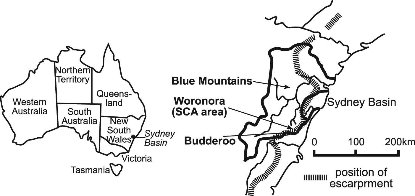
Location of the Blue Mountains, Southern Highlands (SCA) and Southern Highlands (Budderoo) study areas in relation to Sydney.
In the Blue Mountains, Katoomba is situated within the study area and receives 1100–1300 mm of rainfall annually (Bureau of Meteorology (BOM), 2013). The mean maximum temperature is 23°C and 10°C, and mean minimum is 12°C and 3°C in the summer and winter months, respectively (BOM, 2013). In the Southern Highlands, mean maximum temperatures at Moss Vale (approximately 30 km northwest of the study area) range from 26°C in January to 12°C in June (BOM, 2013). Mean minimum temperatures range from 1.3°C in July to 13°C in February. At Robertson, to the west of the Budderoo and Woronora sites, average annual rainfall is approximately 1674 mm/yr. However, a moisture gradient occurs across the plateau, increasing towards the east at approximately 50 mm/km (Burrough et al., 1977). Average annual rainfall over the Southern Highlands swamps ranges from 1600 to 2000 mm/yr. Evaporation on the plateau is lower than mean annual rainfall inputs, creating a positive water budget which is most accentuated in winter (Prosser and Melville, 1988). The study areas occur within a region that experiences multi-decadal El Niño-Southern Oscillation (ENSO) cycles that significantly influence the intensity and duration of rainfall and drought, and associated stream flows and soil moisture (Chiew et al., 1998; Kirkup et al., 1998; Power et al., 1999).
Across the Blue Mountains and Southern Highlands study areas, around 3200 THPSS occur at elevations between 600 and 1100 m a.s.l. These swamps, ranging from 400 m2 (0.04 ha) to 422,000 m2 (42.2 ha), drain catchment areas from 0.036 km2 (3.6 ha) to 0.852 km2 (85.2 ha) and occur on slopes averaging 4.3%. Their elongate shape and size are a direct result of their position in the valley bottoms of dissected plateau sandstone. In many cases, a primary trunk stream swamp is connected to several tributary swamps to form a finger-like configuration. The downstream terminus of these swamps tends to occur at bedrock constrictions, bedrock steps or at the escarpment (Fryirs, 2002; Fryirs et al., 2014).
Floristic composition on these swamps varies spatially with soil moisture and nutrients (Keith and Myerscough, 1993). The central swamp zone tends to support a single stratum assemblage dominated by fern, sedge and tussock species such as Gymnoschoenus sphaerocephalus, Gleichenia dicarpa and Xyris operculata (Hose et al., 2014). At the swamp margins, the lower stratum resembles the central swamp zone, but in place of ferns, grasses (Poaceae) and herbs (such as Empodisma minus) are increasingly common (Hose et al., 2014). The upper stratum in the swamp margin comprises shrubs up to 2 m tall, such as Melaleuca squarrosa, Baeckea linifolia and Leptospermum Juniperinum. The drier hillslopes comprise a woodland association.
Methods
In all, 19 sediment cores, one from each swamp, were cored to bedrock using a 50-cm Russian D-corer. In all cases, the deepest part of the swamp, along the valley axis, was cored. Each 50-cm core was dissected and sampled at 5 cm intervals. Fine-grained sediments (generally <62 µm) were characterised using field texturing. Particles between 62 and 2000 µm (sands) were identified using a hand lens and grain size card. Sediments > 2000 µm (gravels) were measured for average B-axis (intermediate length). A visual note was made of colour (grey brown, dark yellow) and organic matter composition (charcoal, wood fragments).
Bulk density and organic matter content (loss on ignition (LOI)) were measured for each major layer within the valley fills; in total, 118 samples were analysed. To determine bulk density, samples of 50 cm3 were weighed at field moisture (V wet) and placed in a drying oven at 105°C for 24 h. The sample was weighed (M dry) and bulk density calculated. To determine LOI, 20 g samples were dried at 105°C for 24 h (M dry). Samples were then placed in a Lindberg furnace at 500°C for 24 h. Following ignition, samples were transferred to a desiccator for 1 h and again weighed (M ign). The post-ignition weight loss (M dry − M ign) was divided by the initial dry weight (B/M dry) to express organic matter content (% LOI).
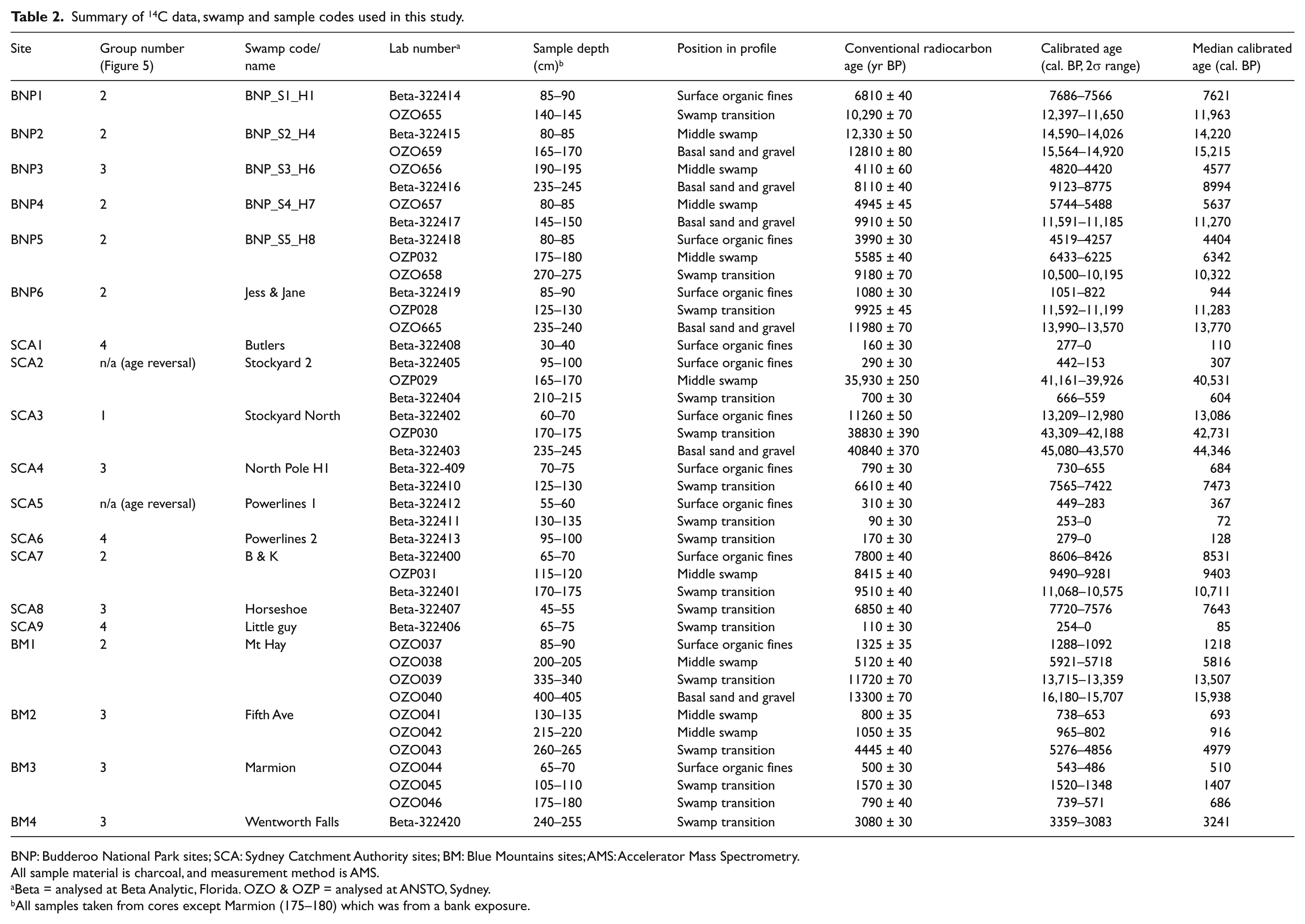
Accelerator Mass Spectrometry (AMS) radiocarbon dating was conducted on charcoal fragments collected from the basal portions of all 19 valley fills to determine the onset of swamp formation. In addition, for swamps that were deeper than 2 m, a middle and upper sample was analysed to obtain a sequence of ages through the valley fill and to calculate average accumulation rates. For swamps less than 2 m deep, only an upper sample was taken in addition to the basal sample. In total, 42 AMS radiocarbon dates were obtained. Charcoal was dated because of the lack of plant macrofossils in the mineral-rich sediments of these swamps. Radiocarbon dating was undertaken at Beta Analytic, Florida, USA and at the Australian Nuclear Science and Technology Organisation (ANSTO), Sydney, Australia. Conventional radiocarbon ages were calibrated using the southern hemisphere calibration data set SHCal13 (Hogg et al., 2013) and the OxCal 4.2 calibration program (Bronk Ramsey, 2009).
The ratio of Total Organic Carbon (TOC) to Total Kjeldahl Nitrogen (TKN) reflects the rate of organic matter decomposition (Rayment and Lyons, 2010). Cores from seven of the deepest (and oldest) swamps were analysed. In addition, contemporary sediments accumulating behind coir log rehabilitation structures at BM3 (in the Blue Mountains) were collected for analytical comparison with cored sediments from the valley fills. In total, 49 C:N ratios were obtained. Sediment (20 g) was tested for TOC and TKN at the National Measurement Institute (NATA Certified Laboratory), Sydney. Interpretation of TOC:TKN (C:N ratios) required a scaling profile (see Rayment and Lyons, 2010). Organic matter accumulation exceeding decomposition produces a C:N ratio > 25–30 and is indicative of peat formation. A ratio of 16–25 indicates accumulation and decomposition in dynamic equilibrium. C:N ratios < 16 reflect the large-scale absence of organic matter and are often associated with mineral subsoils.
Results
Sedimentology of the swamps
Five distinct sediment classes were detected across all 19 studied swamps (Table 1). These sediment classes tend to occur in a consistent sequence within the valley fill. In general, beds of organics and fine mineral sediments sit atop saprolite or bedrock. At the base of the valley fill, dark yellow and grey basal sands and gravels are encountered. This unit consists of coarse–medium, poorly sorted quartz sand in beds between 5 and 45 cm thick. Organic content is low (LOI values average 2.6%), and these layers are compact, producing bulk densities of, on average, 1.32 g/cm3. Immediately above this, layers of fine cohesive sands can occur. This unit is characterised by sandy clay and sandy clay loam textures in beds that are between 5 and 35 cm thick. Organic content is low (LOI values average 7.6%), and bulk density is moderate at 1.11 g/cm3.
Characteristics of sediment classes found in the swamps.
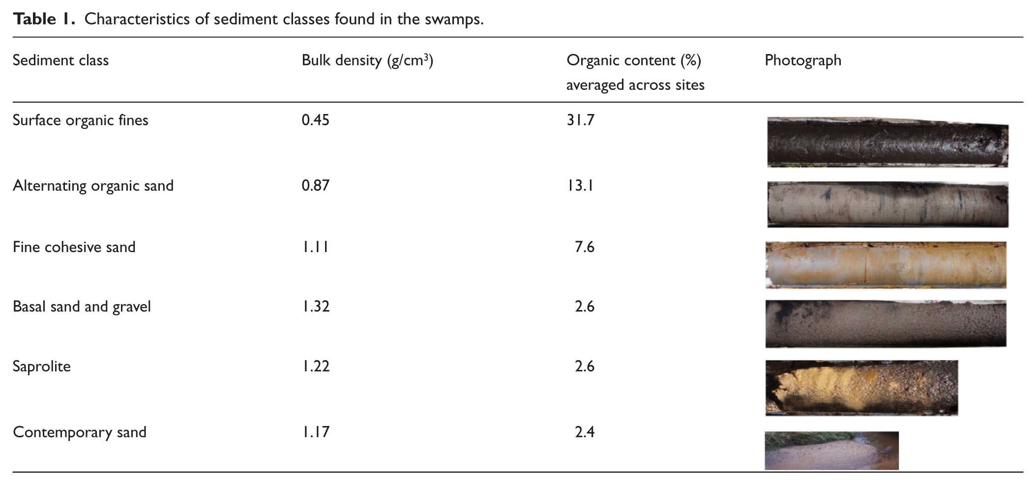
Atop fine cohesive sands, alternating organic sands comprise stacked beds of dark brown loams and sandy loams that are separated by (or alternate with) light, very fine sand layers. These layers comprise the majority of swamp deposits. Individual sub-layers are between 5 and 55 cm thick, but the overall thickness of the alternating organic sand unit can be as much as 1.95 m. Occasional, thin (<10 cm) coarse sand sheet deposits punctuate these sequences. Parts of this unit are dark brown (even black) in colour, with little coarse organic matter. Organic content is highly variable between sand and loam sub-layers, averaging 13.1% but extending from 79.9% for some loam layers to as little as 1.1% for the thinner sand layers. Bulk density for these units is low at 0.87 g/cm3. The fine cohesive sand and alternating organic sand classes are considered the sapric component of the swamp sediments.
At the surface of all swamps, black humic surface organic fines are found. These layers are on average approximately 20–100 cm thick, have a higher organic matter content (LOI averages 31.7%) and are poor in mineral sediment. A high proportion of live and dead coarse organic matter forms an open matrix structure, resulting in a low bulk density of 0.45 g/cm3. The surface organic fines unit is considered the fibric component of the swamp sediments. Where swamp surface incision has occurred, or at the margins of many swamps adjacent to bedrock outcrops, coarse contemporary sands may locally occur. These sand sheets comprise coarse, poorly sorted mineral sand with little organic matter (LOI averages 2.4%).
All study swamps contain sequences of at least surface organic fines and alternating organic sands (Figures 2–4). The occurrence of basal sands and gravels, fine cohesive sand and contemporary sand layers is localised. However, there is significant variability in the extent to which each layer is represented in each swamp, and the continuity and thickness of the layers. In particular, the internal structure of the alternating organic sands layers can be complex with little consistency evident in the number or thickness of beds represented in each swamp.
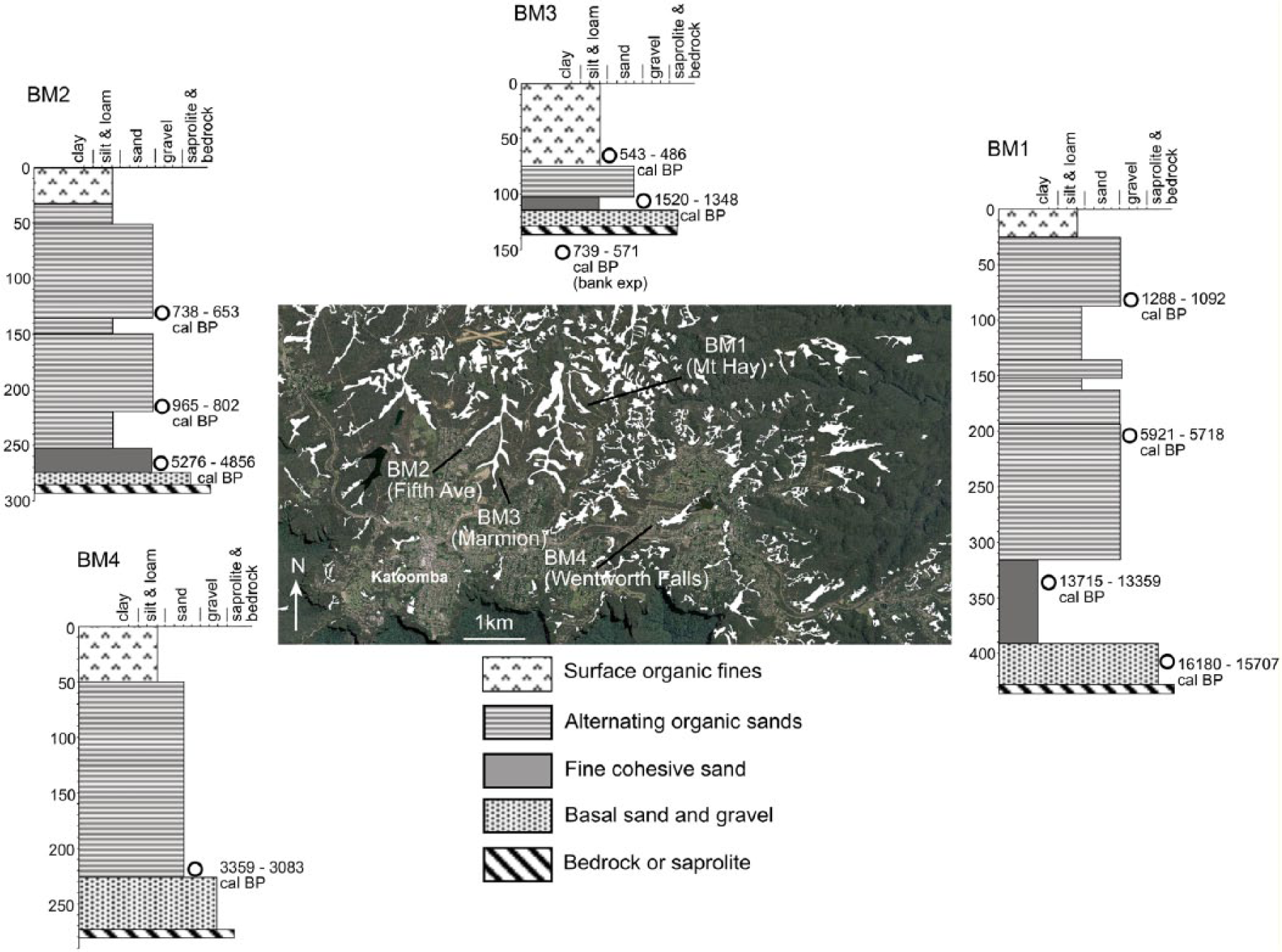
Study swamps in the Blue Mountains (BM sites). Sediment columns and radiocarbon ages are presented. The swamps are represented by white fill on aerial photographs.
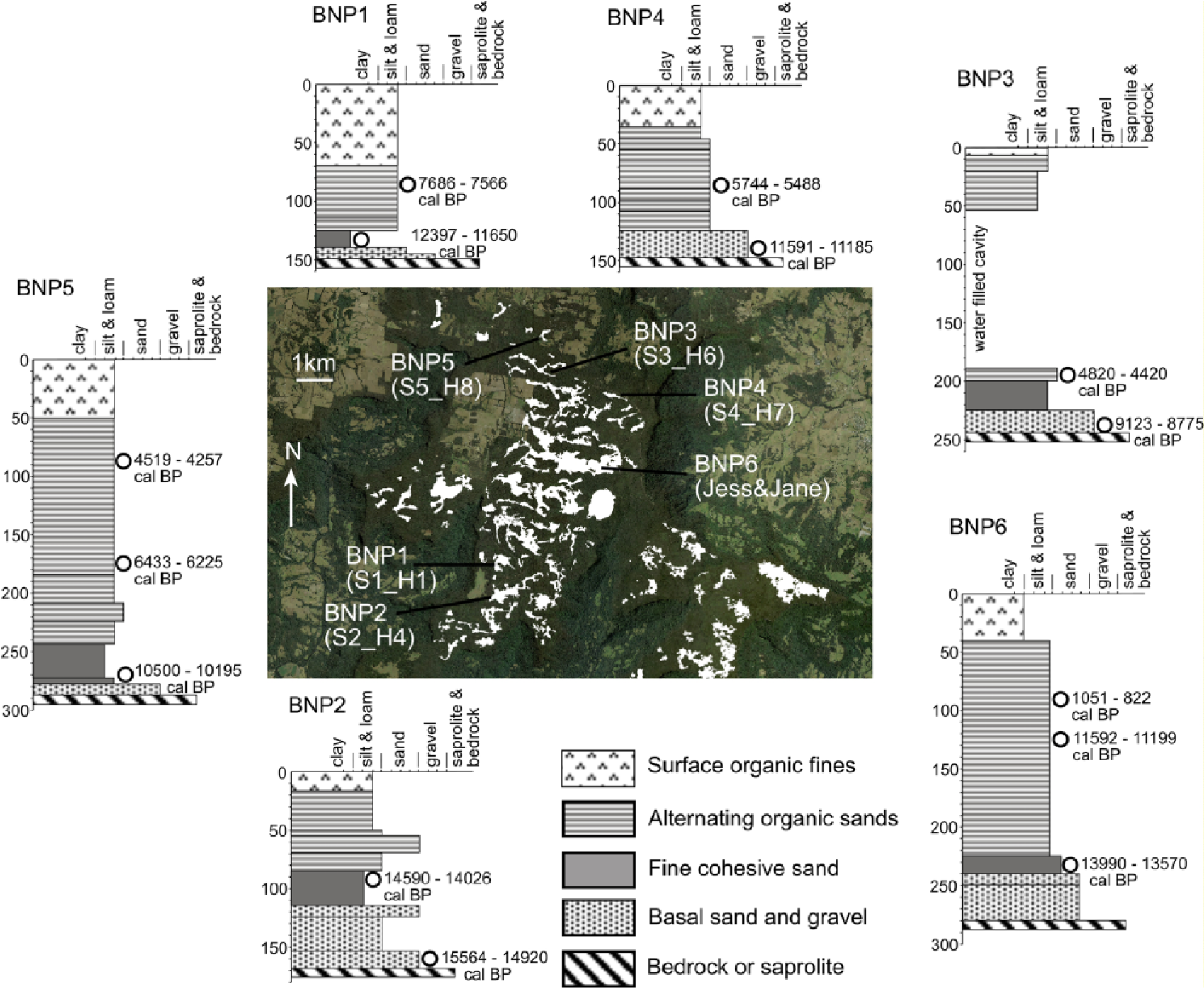
Study swamps in the Budderoo National Park (BNP sites). Sediment columns and radiocarbon ages are presented. The swamps are represented by white fill on aerial photographs.
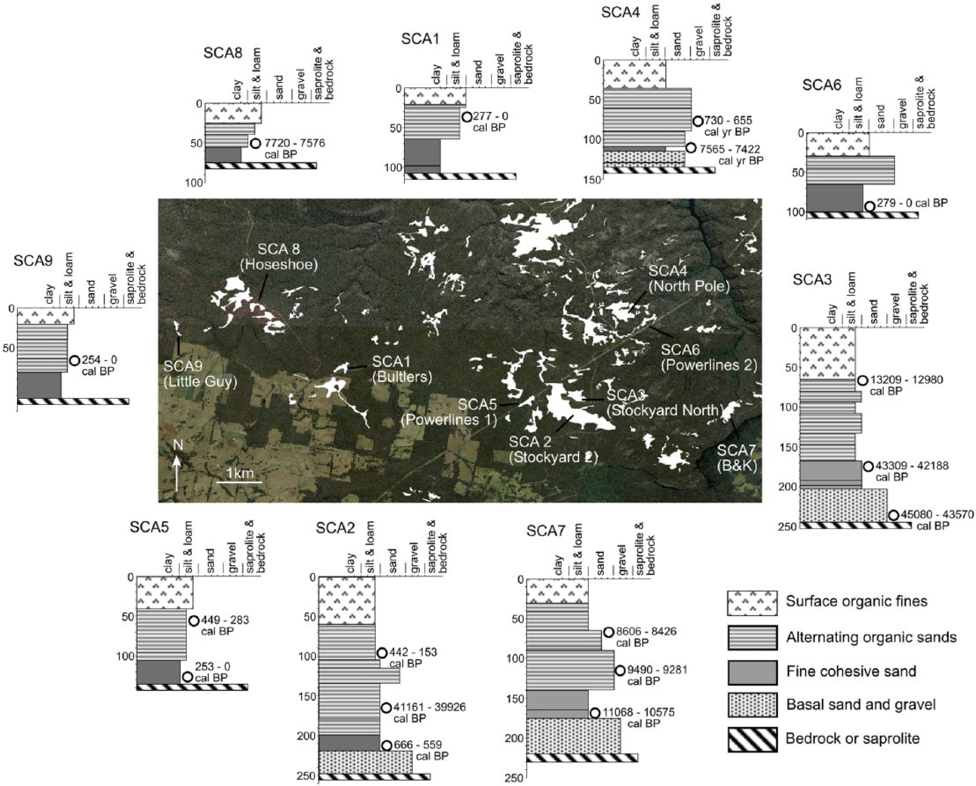
Study swamps in the Southern Highlands/Woronora area. These swamps are located in the Sydney Catchment Authority area (SCA sites). Sediment columns and radiocarbon ages are presented. The swamps are represented by white fill on aerial photographs.
Age structure and carbon:nitrogen (C:N) ratios
Across the 19 swamps analysed, only two contained age reversals (SCA2 and SCA5; Figure 4 and Table 2). In both these cases, the bulk of the sediment is young (<700 years) except one date in SCA2 where an age of 41,161–39,926 cal. BP occurs in the middle of the profile. The dates for these swamps are considered with caution, as charcoal may have been re-worked prior to deposition (Blong and Gillespie, 1978).
Summary of 14C data, swamp and sample codes used in this study.
BNP: Budderoo National Park sites; SCA: Sydney Catchment Authority sites; BM: Blue Mountains sites; AMS: Accelerator Mass Spectrometry.
All sample material is charcoal, and measurement method is AMS.
Beta = analysed at Beta Analytic, Florida. OZO & OZP = analysed at ANSTO, Sydney.
All samples taken from cores except Marmion (175–180) which was from a bank exposure.
Old ages are reported following the recommendations of Stuiver and Pollack (1977). The Limit of Detection for the two oldest samples in the set (OZP029 and OZP030; Table 2) is ~57,000 yr BP. The two C14 ages with 2 sigma error are not close to background and are therefore considered valid.
For those swamps where waterlogged basal sand retrieval was possible, just above saprolite (six swamps), the age structure spans 15,564–14,920 cal. BP to 9123–8775 cal. BP with an outlier back to 45,080–43,570 cal. BP in SCA3 (Figures 2–4 and Table 2). This suggests that sand trapping and accumulation in these valleys was initiated at the Pleistocene–Holocene transition, or earlier.
In all, 17 swamps were used to determine timing of the transition from the basal sand and gravel unit to the fine cohesive sand or alternating organic sand units (i.e. all swamps except those where age reversals occur; Figure 5 and Table 2). For one swamp (SCA3), this transition is dated at 43,309–42,188 cal. BP. If the age in SCA2 is used, an equivalent date of 41,161–39,926 cal. BP falls into this group (Group 1). In seven swamps, this transition is dated in the Late-Pleistocene from 15,564 to 14,920 cal. BP to 10,500–10,195 cal. BP (Group 2). Six swamps have the transition occurring in the Holocene from 7720 to 7576 cal. BP to 1520–1348 cal. BP (Group 3) with all but two occurring in the last 5000 years. These ages suggest that the transition to some form of ‘swamp’ accumulation was occurring most extensively across the region at the Late-Pleistocene and throughout the Holocene. Three smaller, shallower swamps are modern, with ages between 277 and 0 cal. BP and 254 and 0 cal. BP (Group 4).
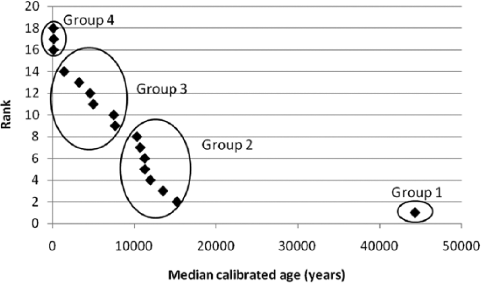
Calibrated radiocarbon age versus rank curve for the transition to ‘swamp’ forming conditions across the study areas. The ages here are for the fine cohesive sand or alternating organic sand units that sit immediately atop basal sand and gravel units. The designation of Groups 1–4 are based on significant gaps in the age profile of the study swamps.
Four swamps from Group 2, and two from Group 3 have depth profiles for C:N ratios (Figure 6). These are some of the deepest swamps in the study, ranging from 420 cm (BM1) to 110 cm (BM3) in depth. Samples from contemporary, incised channel sand sheets in the highly disturbed BM3 swamp were also analysed. For the oldest swamps (Groups 1 and 2), C:N ratios for the layers immediately above the basal sands (i.e. reflecting the transition to ‘swamp’ forming conditions) range from 27 to 42, meaning that peat formation has occurred in these swamps early in their evolution. For the younger swamps in Group 3, the C:N ratios at this transition range from 15 to 29, placing them in the accumulation-equilibrium category where peat formation is in its infancy. The contemporary sands returned C:N ratios of mostly <15 suggesting no peat formation and the absence of organic matter accumulation.

Carbon:nitrogen ratio (C:N) profiles or representative swamps across the study areas.
Additional ages were calculated from the surface organic fines layers. Most ages were taken at between 75 and 100 cm depth (Figures 2–4 and Table 2). The swamp in Group 1 (SCA3) has a surface age of 13,209–12,980 cal. BP. Across the seven swamps in Group 2, surface age structures range from 14,590 to 14,026 cal. BP to 1288–1092 cal. BP. Five of the swamps in this category have near-surface sediments older than ~44,00 cal. BP. The remainder of the swamps (Groups 3 and 4) have surface sediments between 730 and 655 cal. BP and 254 and 0 cal. BP. The C:N ratios down to 70 cm depth are highly variable, ranging from 14 to 42, but reduce to less than 30 at the surface (0–30 cm) in all but one case – BM1 recorded a high peat-forming ratio of 57 at the surface.
For the four swamps where a stratigraphic sequence of three dates is available, average sediment accumulation rates are highly varied and not significantly different at various stages of swamp development. For the basal part of the profile spanning the transition from basal sands to sapric fines accumulation, rates range from 2.13 to 39.27 mm/100 yr. For the upper part of the profiles spanning the sapric to fibric sediments, rates range from 4.15 to 90.08 mm/100 yr. For the five swamps where only two dates are available, accumulation rates range from 7.94 to 98.64 mm/100 yr.
Discussion
Formation and evolution of the upland swamps, and peat-forming potential
For the swamps studied here, a representative evolutionary sequence of THPSS formation can be presented (Figure 7). In the period post-Last Glacial Maximum (LGM), sand and gravel trapping and accumulation on low-slope valley floors is initiated when the transport capacity of upland streams is reduced. In some valleys, this condition may have occurred over several thousand years. The initial onset of sediment trapping is dated at between 15.3 and 9 kyr cal. BP, but may have been occurring since 44 kyr cal. BP.
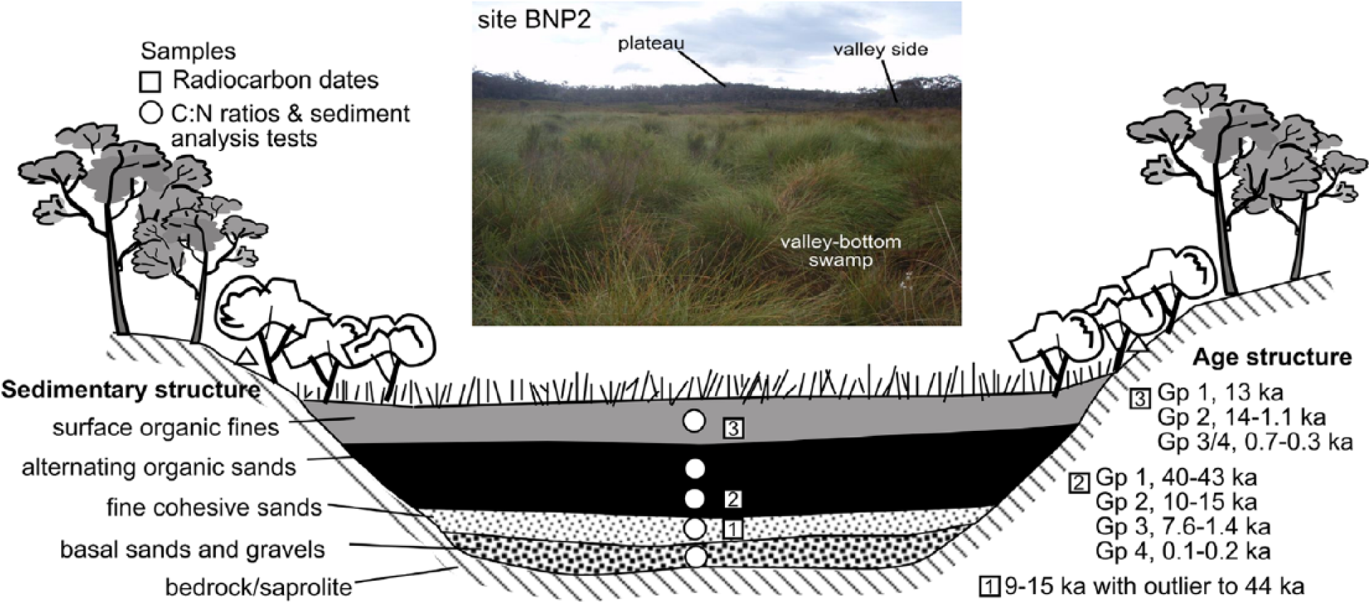
A representative model of THPSS sedimentology, age structure across the study areas.
With increased temperature and rainfall at the onset of the Holocene, vegetation became well established on valley floors and adjacent hillslopes (Cohen and Nanson, 2007). This likely produced the conditions conducive to accumulation of organic matter and trapping of fine sands in these valley bottoms. This transition to a ‘swamp’ system through paludification (cf Anderson et al., 2003) occurred between 15.2 and 10.3 kyr cal. BP in some systems, and between 7.6 and 1.4 kyr cal. BP in other, adjacent valleys. Some valleys did not develop ‘swamp’ systems until recently (last couple of hundred years). The variability in ‘swamp’ ages suggests that although a significant transition to swamp forming conditions through paludification occurred in the Late-Pleistocene, there have also been phases of swamp development throughout the Holocene. The fine cohesive sand and alternating organic sand units reflect localised deposition processes that contribute to swamp accumulation and the varying extent to which organic matter accumulation and decomposition have occurred over time. These units are the product of these major ‘swamp’ building phases.
Depending on the extent of plant matter compaction and an anaerobic environment induced by waterlogged conditions, a carbon accumulating system formed in some swamp fills (Clymo et al., 1998; Grand-Clement et al., 2013). With the maintenance of a wetter climate over decadal timescales, conditions may have been locally favourable for peat formation (Pemberton, 2005; Whinam et al., 2003). However, the sedimentology of the fills suggests that this was not a continuous process. Recurrent layering of coarse sands and peat-like organic material may reflect the transport and deposition of coarser, mineral-rich, sand sheet sediments following fire or high-intensity storm/runoff events and subsequent re-establishment of vegetation on hillslopes and valley floors (Black and Mooney, 2006; Buckman et al., 2009; Gomez et al., 2011; Whinam et al., 2003). These events not only disrupted the stratigraphy of the fill but the peat-forming conditions within the fill. The relatively low C:N ratio values throughout the valley fill profiles suggest that while peat can form in these systems, it is not well developed and has only occurred at certain times during the evolution of the fill. A more detailed analysis of C:N ratio profiles has the potential to record, more accurately, periods of peat formation within these systems.
Across the study swamps, near-surface ages in the surface organic fines unit range from 13.1 to 0.7 kyr cal. BP. Eight swamps (42%) have surface ages that have been well established for some time (> ~44,00 cal. BP; Table 2). All occur in the SCA or BNP geographical areas. This could suggest that rates of accumulation and sediment supply are locally very low, or that active swamp accumulation has ceased.
The evolution of these systems is analogous to others in the region, suggesting that a regional model of THPSS is emerging. Upland swamp initiation across south eastern Australia typically extends from the Late-Pleistocene to the Late Holocene (Table 3). In some locations, THPSS formation commenced during the Late-Pleistocene between 15 and 18 kyr BP (e.g. on the Woronora, Hornsby and Blue Mountains Plateaus; Fryirs et al., 2014; Stockton and Holland, 1974; Sullivan and Hughes, 1983; Tomkins and Humphreys, 2006; Young, 1986a). While not equivalent in structure and composition to the THPSS, Sphagnum and Button grass swamps found on the higher Australian Alps and Barrington Tops Plateaus also record Late-Pleistocene and Early-Holocene basal ages (Table 3; Dodson, 1987; Grover and Baldock, 2010; Hope et al., 2009; Macphail and Hope, 1985; Nanson, 2009; Pemberton, 2005; Sweller and Martin, 2001). While many of the dates in Table 3 may be uncalibrated, calibration would not alter the dates significantly, and it can be concluded that this range of basal ages suggests that the conditions conducive to upland swamp development in south eastern Australia emerged after the LGM when regional climate was warmer, and wetter conditions prevailed (Buckman et al., 2009; Cohen and Nanson, 2007; Finlayson and McMahon, 1988; Nanson, 2009). However, there is significant variability in the basal ages of swamps in these settings (and the 19 swamps documented in this study), suggesting controls other than an allogenic, regional climate also dictate when sediment and organic matter accumulation was initiated in any given valley, and the rate at which the valley fill accumulates. Prosser et al. (1994), Fryirs (2002), Tomkins and Humphreys (2006), Anderson et al. (2003) and Lavoie et al. (2013) note that a range of intrinsic, autogenic thresholds and controls are also a significant factor in temperate, upland swamp formation. For example, the slope and configuration of a valley dictate the extent to which sediment trapping can occur. In addition, the rate of sediment supply from adjacent hillslopes, the type and coverage of vegetation and associated organic matter input and the rate and extent to which the hydrological ‘function’ of the valley fill is established (i.e. surface and/or subsurface water interactions and levels) all control when, and to what extent, a THPSS will form.
Basal ages of some upland swamps in south eastern Australia.
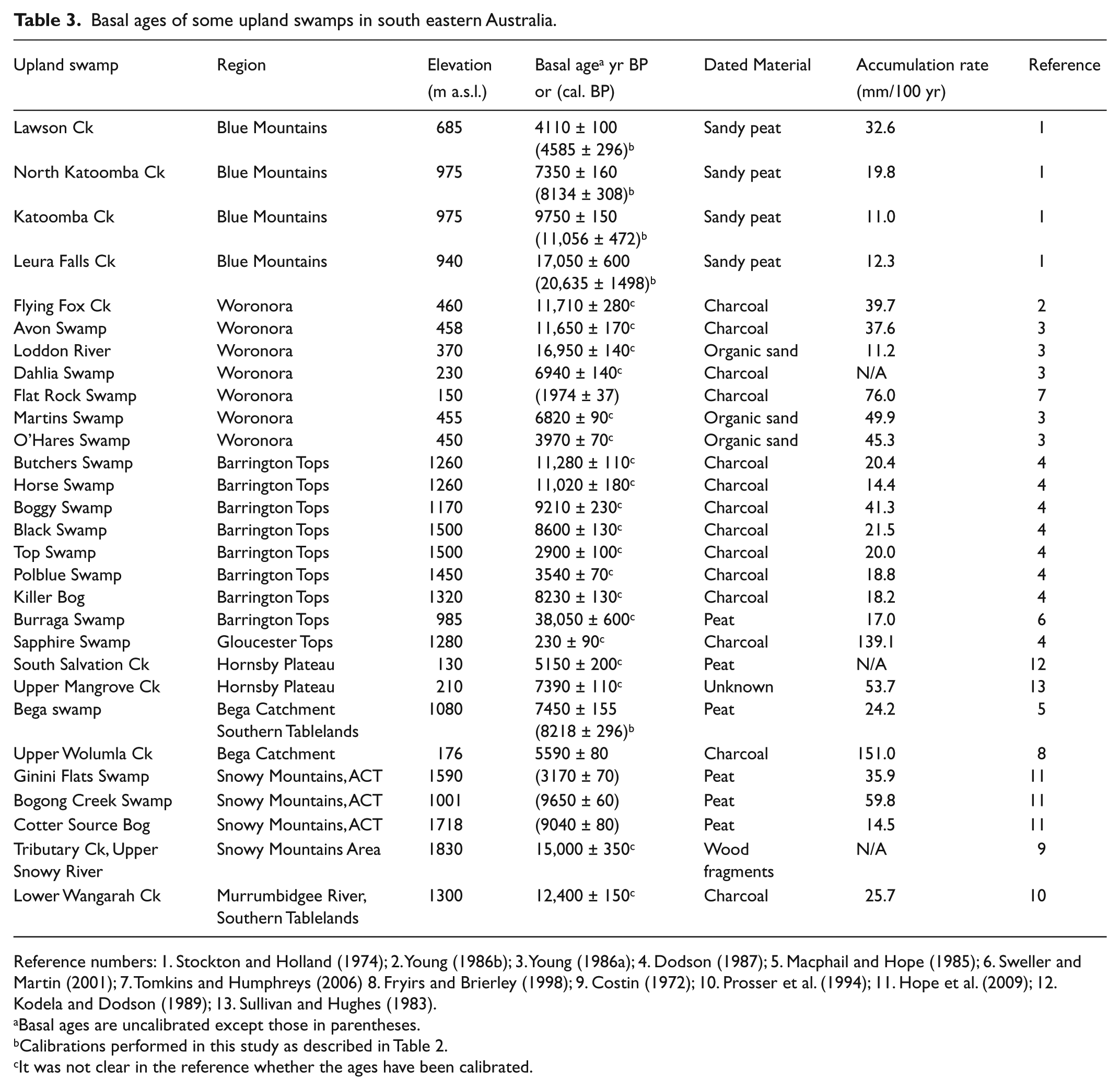
Reference numbers: 1. Stockton and Holland (1974); 2. Young (1986b); 3. Young (1986a); 4. Dodson (1987); 5. Macphail and Hope (1985); 6. Sweller and Martin (2001); 7. Tomkins and Humphreys (2006) 8. Fryirs and Brierley (1998); 9. Costin (1972); 10. Prosser et al. (1994); 11. Hope et al. (2009); 12. Kodela and Dodson (1989); 13. Sullivan and Hughes (1983).
Basal ages are uncalibrated except those in parentheses.
Calibrations performed in this study as described in Table 2.
It was not clear in the reference whether the ages have been calibrated.
Peat swamps in eastern Australia?
In truly peat-forming systems, relatively stable climate produces near-constant waterlogging and anaerobic conditions that slow organic matter decay (Clymo et al., 1998). Differences in peat accumulation rates in these systems result from variations in the duration and level of inundation and the dominant vegetation type (see discussion below; Grundling et al., 2013). The persistence of peatlands in other settings with a more variable climate (e.g. Australia, Africa and South America) requires water inputs from large catchments or sustained local groundwater input (Grundling et al., 2013; Meadows, 1988; Tooth and McCarthy, 2007; Von der Heyden, 2004). Where these conditions are not met, peat-forming potential is limited.
Unlike peatlands formed elsewhere (Grand-Clement et al., 2013; Haapalehto et al., 2011), long-term peat formation in THPSS has not occurred. Instead, C:N ratio spikes in cohesive and alternating organic sand units reflect short phases of anaerobic conditions and peat formation in the evolution of the swamp. The THPSS of eastern Australia form under climate conditions that experience significant inter-annual variability in rainfall and ENSO cycles of high-intensity rainfall events and long periods of drought (Chiew et al., 1998; Finlayson and McMahon, 1988; Kirkup et al., 1998). These climatic conditions became more pronounced in the Late-Holocene (Black et al., 2008; Buckman et al., 2009; Cohen and Nanson, 2007; Donders et al., 2007; Gomez et al., 2011) and are marginal for peat formation. Fryirs et al. (2014) document the hydrological function of one of the THPSS study sites presented in this paper (swamp BNP6), recording the highly variable nature of water level conditions in this system over a 2-year period. Mean water level occurs at depth within the valley fill, and water level fluctuations expose the fibric and upper parts of the sapric layers to dry, aerobic conditions for extended periods of time. During wet times, the swamps will fill with water, but the recession after rain is steep and water levels retreat back to mean condition relatively quickly (within 3–5 days). This form of hydrological function has the potential to limit peat formation in these systems as organic matter becomes fully decomposed and lost to the system. Under these conditions, periods conducive to peat formation are brief rather than sustained.
Dominant vegetation and sediment types are also a significant control on peat formation. Recorded rates of accumulation in truly peat-forming systems are between 0.3 and 2 mm/yr (Borren et al., 2004; Dommain et al., 2011; Gorham et al., 2003; Hope et al., 2005; Wüst et al., 2008). Mineral-sediment poor, Sphagnum-dominated systems commonly have the most rapid accumulation rates, because of a resistance to decay (Grundling et al., 2013), with lower rates of peat formation and accumulation in systems dominated by sedge and trees (Dommain et al., 2011; Grundling et al., 2013). The THPSS are mineral-sediment (sand) rich systems, dominated by fern, sedge and tussock species (Hose et al., 2014; Keith and Myerscough, 1993) that decompose more readily in the oxygenated subsurface, and even more rapidly in degraded systems. Valley fill accumulation rates of the THPSS are very slow, in the order of ~5–100 mm/100 yr, with the majority of this accounted for by irregular inputs of mineral sediment to the system, not peat formation.
C:N ratios within surface fines indicate potential for peat formation under current climatic conditions. Most of the surface organic fines layers of the valley fills show signs of immature peat formation. Given the relatively old age structure of these surface sediments (Mid–Late Holocene), this suggests that either (1) peat formation is occurring but very slowly in these systems, or (2) peat formation has arrested or ceased sometime in the last several hundred and thousands of years. The maintenance of waterlogging will dictate whether future peat formation occurs and legislative protection of these systems will play a role in maintaining undisturbed hydrological function.
Little discussion has occurred on whether the hydrological function of these systems will change under future climate change and what effect this may have on maintenance of swamp structure (including peat formation), and associated biodiversity (Mitsch et al., 2013; Moore, 2002). The effects of climate change are likely to be manifest initially in sensitive subalpine and highland areas of the world where changes in the intensity and duration of droughts and rains are forecast (Essl et al., 2012; Gong et al., 2012; Leifeld et al., 2012). The threat to THPSS in particular is great and questions about the preservation and conservation of these systems remain.
Conclusion
THPSS across the Blue Mountains and Southern Highlands regions of eastern Australia have a similar sedimentary structure, with swamp formation having commenced around the Late-Pleistocene/Early-Holocene transition. However, significant variability in basal ages between THPSS implies a mix of allogenic and autogenic controls are responsible for the formation of these swamps. Throughout their evolution, a high susceptibility to dewatering during ENSO cycles may have contributed to them being poor peat-forming systems. A regional model of THPSS formation and evolution is emerging that will better inform management actions for these endangered ecological communities.
Footnotes
Acknowledgements
We thank Nicole Ashby for her assistance in the field. This work was conducted under NSW NPWS Scientific Licenses and a Sydney Catchment Authority license. Two anonymous reviewers provided useful comment on the paper.
Funding
This project was supported by a Macquarie University Research and Development Grant, an Australian Research Council grant (LP130100120) and a grant awarded under the Department of Sustainability, Environment, Water, Population and Communities (DSEWPaC) and Australian National University (ANU) Research Program on Temperate Highland Peat Swamps on Sandstone (THPSS). AINSE Grants 11/059P and 12/088 supported some of the radiocarbon dating.