
Abstract
The Holocene history of outlet glaciers affords information on the behavior and mechanisms controlling the extent of the East Antarctic Ice Sheet. Here, we present both new radiocarbon and recalculations of previously published cosmogenic exposure-age data that constrain Holocene ice dynamics along upper Reedy Glacier in the southernmost Transantarctic Mountains. Ice remained at or close to its last glacial maximum position until the early Holocene, at which time it underwent thinning. A period of apparent relative stability in the mid-Holocene led to the formation of ice-dammed proglacial ponds, as well as of moraines located roughly two-thirds of the distance from the maximum position to the present-day ice margin. Renewed thinning began after 3600 yr BP, with ice reaching present-day levels by 2400 yr BP. Ice variations along upper Reedy Glacier likely reflect the balance between upstream propagation of mechanical thinning events at the glacier mouth and regional accumulation changes.
Keywords
Introduction
Outlet glaciers in the Transantarctic Mountains drain a significant portion of the East Antarctic Ice Sheet (EAIS) and strongly control its mass balance. Thus, documentation of outlet-glacier history and the climatic and glaciological factors driving changes in their extent and behavior is key for understanding Antarctic glaciation, as well as for assessing the Antarctic contribution to past and future global sea-level changes. In addition, knowledge of Antarctic cryosphere behavior is an important component for interpreting Southern Hemisphere climate fluctuations.
Most studies of outlet glaciers in the Transantarctic Mountains have focused on the last glacial maximum (LGM) and on the general pattern of subsequent ice down draw as the grounding line of the Ross Sea Ice Sheet (RSIS) retreated southward at the end of the last ice age (Bockheim et al.,1989; Bromley et al., 2010, 2012; Denton et al., 1989; Todd et al., 2010), or, more rarely, on previous glaciations (Higgins et al., 2000; Joy et al., 2014). Few studies have examined the age, pattern, and significance of Holocene recessional or readvance moraines alongside EAIS outlet glaciers. Thus, the general behavior of these glaciers during the Holocene, including the relative timing of events between different glacial catchments and the causes of ice fluctuations, remains uncertain because of poor spatial coverage of well-dated records (Hall, 2009). As a step toward improving knowledge of outlet-glacier history through the Holocene, we present a radiocarbon-dated record – to our knowledge, the most southerly radiocarbon dates ever obtained – of Holocene fluctuations of upper Reedy Glacier, southern Transantarctic Mountains.
Setting
Reedy Glacier (Figure 1), a large outlet of the EAIS that, at present, flows into the West Antarctic Ice Sheet (WAIS), forms the primary tributary of Mercer Ice Stream. During the LGM, surface-level change in the WAIS caused differential thickening of Reedy Glacier, with ice near the mouth reaching ~500 m above present levels (Bromley et al., 2010). In contrast, the thickness at the head of the glacier, at the East Antarctic plateau, increased only 40 m (Bromley et al., 2010). Moreover, the timing of maximum local ice thickness, represented by the Reedy III drift (Bromley et al., 2010; Mercer, 1968) and dated with cosmogenic isotopes, appears to have varied along the glacier, occurring first near the mouth at ~14,000–17,000 yr BP and then at progressively younger times upglacier (Todd et al., 2010).
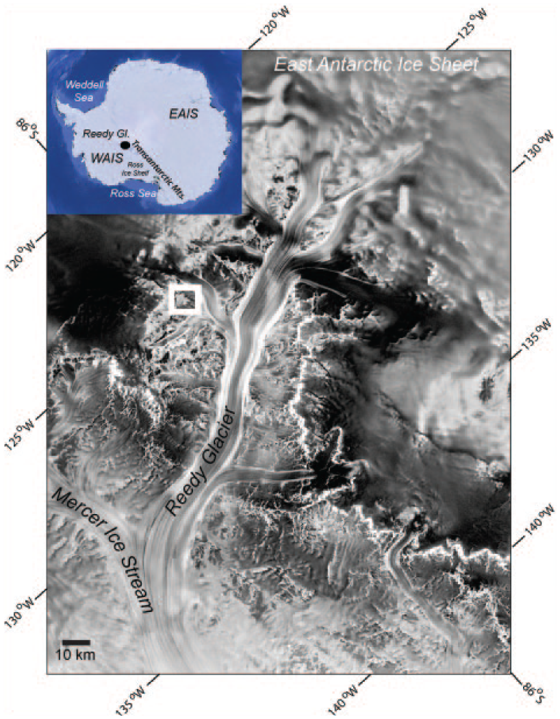
RADARSAT image of Reedy Glacier, showing the context of the Polygon Spur field area (white box).
Our data come from Polygon Spur (86°S, 126°W), a small (~40 km2), ice-free area near the confluence of Reedy and McCarthy Glaciers (Figures 1 and 2) and ~75 km from the East Antarctic plateau. At this site, distributary ice lobes flow eastward into small valleys that are separated by low, rounded bedrock hills. Tiny (<0.5 km2) proglacial ponds abut four of these lobes (Figure 3; Grand Mummy, Snap, Crackle, and Pop, informal names following existing nomenclature of Bromley et al., 2010). These water bodies are shallow and probably are frozen to the bottom, except along the edges, where a narrow (<1 m wide), shallow (<10 cm deep) moat is open in summer. We observed modern cyanobacterial mats growing around rocks in the moat of only one of these ponds, Grand Mummy. In general, meltwater is uncommon and forms supraglacially only on clear, sunny days, even when air temperatures are well below freezing. We observed thin, slow-moving films of meltwater on the glacier surface at ~−8 °C. All meltwater entering these ponds at Polygon Spur appears to come from such films.
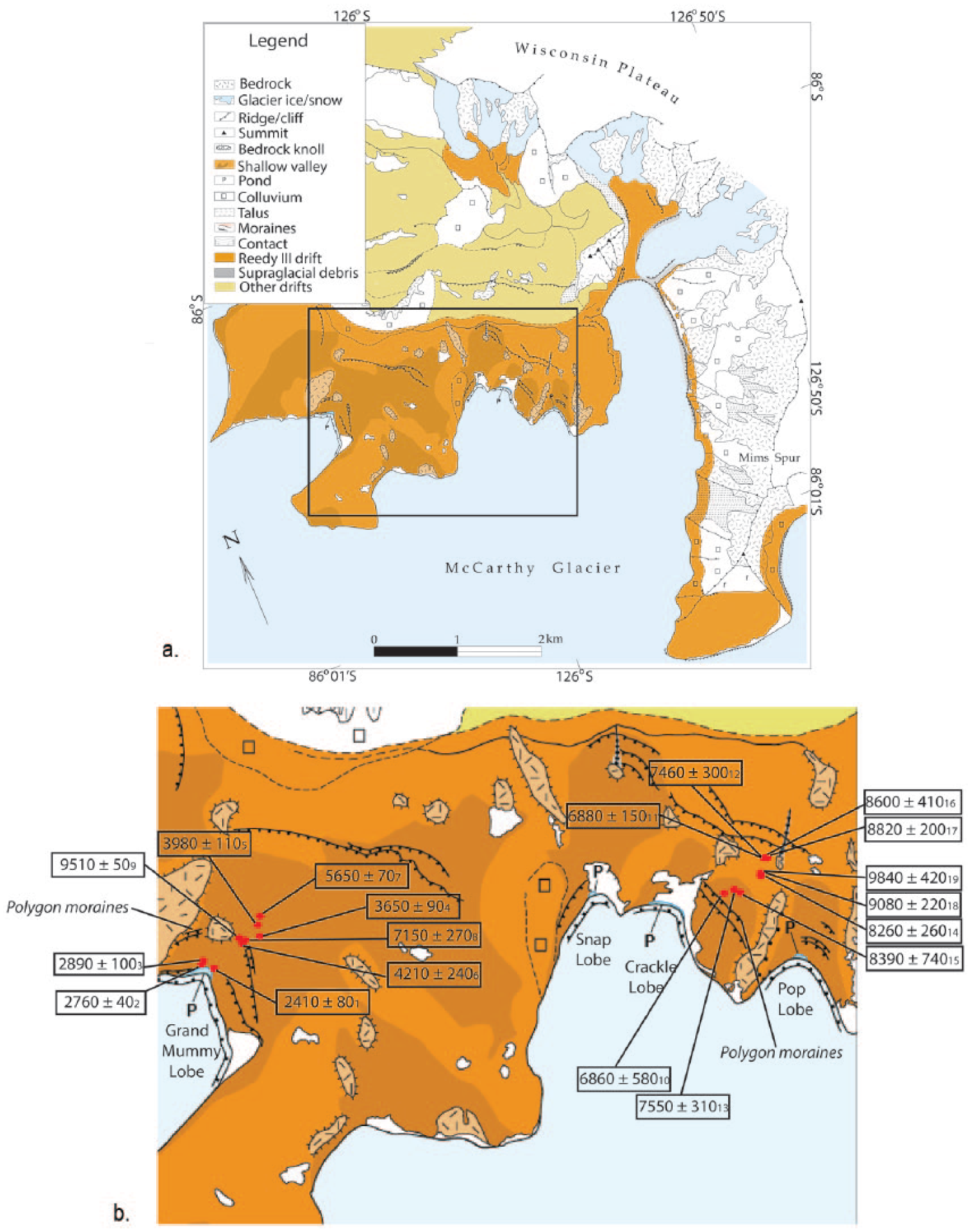
Location of samples and sites at Polygon Spur. (a) Map shows study site in the context of the surficial geology in the Polygon Spur region (Bromley et al., 2010). The box outline shows the location of the map in (b), which details specific locations of dated cyanobacteria samples. Dates are in calendar years and are shown in Table 1.
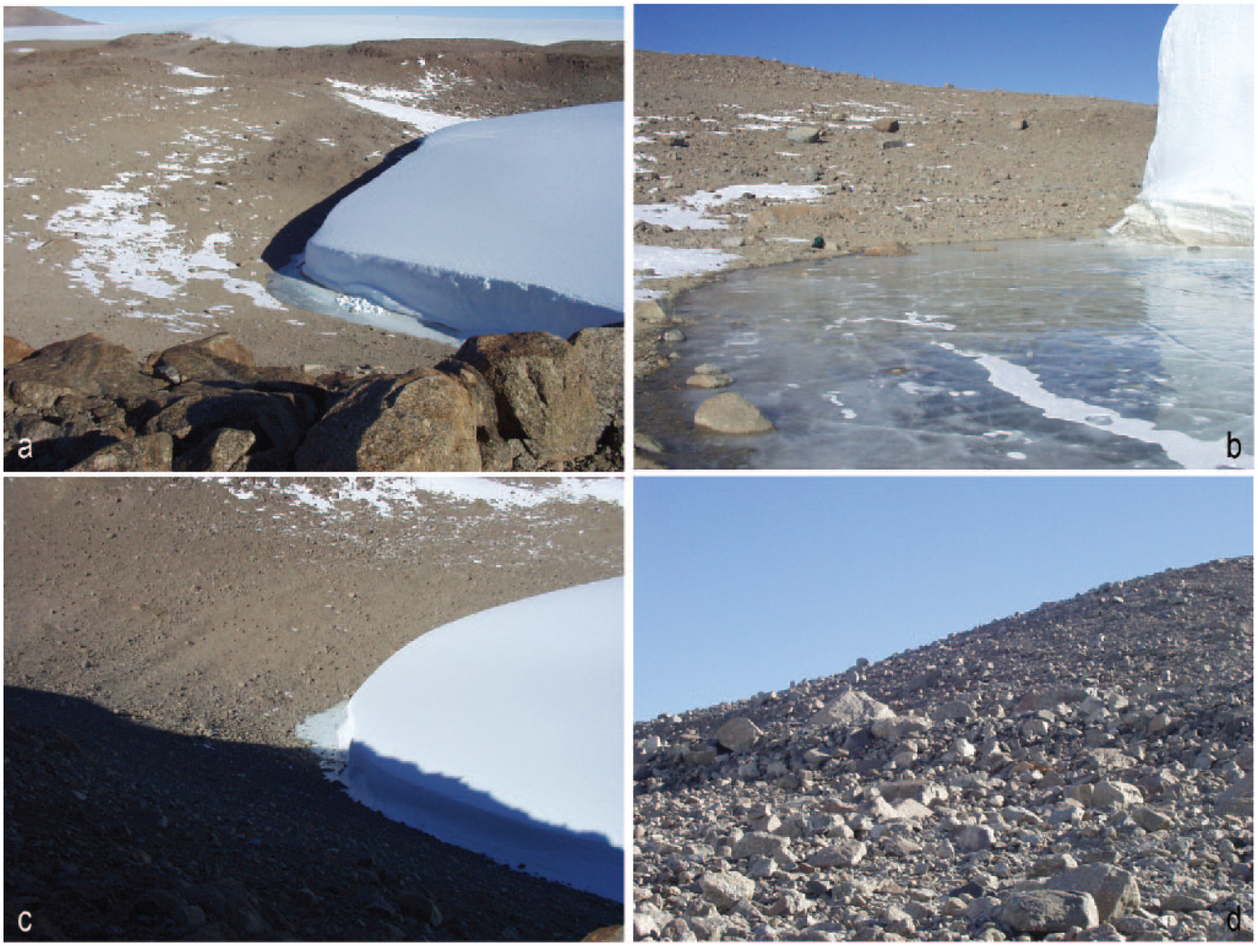
Photographs of features at the ice margin, Polygon Spur. (a) View of Grand Mummy Pond and adjacent valley. The pond abuts the Grand Mummy lobe, which terminates in a cliff. Ice from fresh calving can be seen on the ice-covered pond surface. (b) Close-up view of Grand Mummy Pond, showing ice surface and small moat of unfrozen water (dark color at lake edge). (c) Polygon moraines adjacent to the Pop lobe, where they are well-preserved. Pop Pond is visible adjacent to the ice margin. (d) Close-up view of a Polygon moraine adjacent to the Snap lobe. These moraines typically have ~1 m of relief.
In order to reconstruct a history of the ice margin, we documented the past existence and migration of these proglacial ponds, as well as their relationship to a recessional position marked by a discontinuous moraine in all the valleys (Figures 2 and 3). In the far southern Transantarctic Mountains, water bodies tend to be small, shallow, and located immediately adjacent to the ice margin. The existence of most ponds at these latitudes depends on the glaciers, as there are no other sources of water (what little snow there is largely sublimates and kettle ponds from buried ice deposits are local in extent). Where the topography slopes downward toward the ice, the geometry is such that ponds cannot exist without an ice dam. Thus, as the glacier margin fluctuates, the position of the ponds moves up and down the slope (Figure 4). Therefore, relict pond deposits give estimates of former ice-marginal positions. Excluding mostly minor oscillations in water level because of the variations in meltwater influx (although large-scale variations are possible, particularly in warmer areas; Hall et al., 2010, Hodgson and Bentley, 2013), the changes in pond elevation primarily reflect glacier fluctuations.
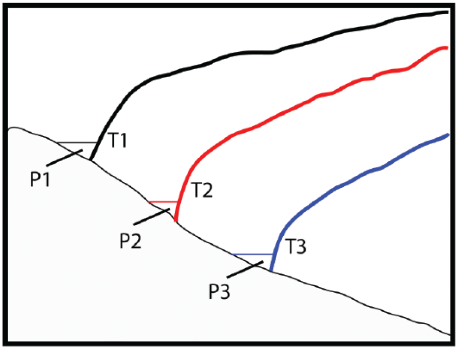
Schematic model of marginal pond migration with thinning ice on slopes. As time (T) progresses, the glacier retreats and the corresponding ice-dammed pond (P) must follow the receding ice.
Our goal was to use relict pond deposits to constrain former ice positions. With little meltwater input and minimal open water, these small ponds typically preserve very little record of their existence. Sediments consist of wind-blown sand and rare fine sediment concentrated preferentially in the narrow moat zone. Cyanobacterial mats are interbedded within the sediments, particularly the silts, and are preserved best around and beneath rocks once the lake recedes. Small ‘step and tread’ shorelines are present, but commonly landforms are faint and difficult to detect. Thus, most evidence for the former proglacial ponds at Polygon Spur is based on the existence of relict in situ lacustrine cyanobacterial mats in stratified sand, rather than on prominent landforms. These cyanobacteria afford the basis for a radiocarbon chronology. Moreover, because the glacier tongues are cold-based and their advances may not disturb the substrate, buried mats have the potential to survive glacial overriding and document glacier oscillations, which are not recorded by cosmogenic nuclides.
Methods
We collected ancient in situ cyanobacterial mats for radiocarbon dating. Search methods were based on experience finding such mats farther north in Transantarctic Mountains (Bockheim et al., 1989; Hall and Denton, 2000; Hall et al., 2010, 2015). We worked uphill from the present ponds, digging beneath and around rocks and excavating sediments that preserved horizontal stratigraphy. Elevations were obtained by a Novalynx barometric altimeter calibrated twice daily to a local GPS base station. We estimate overall vertical error is better than ±5 m and the relative vertical position of the samples to each other is better than ±2 m in Grand Mummy Valley and ±3 m in South Crackle Valley. The cyanobacteria, already freeze-dried, were stored in glass vials in cool storage. The samples were dated at the University of Arizona AMS laboratory. We converted the ages to calendar years, using CALIB 7.0.1 and the INTCAL13 dataset (Reimer et al., 2013); all radiocarbon dates in the text are expressed in calendar years with a 2σ error. We did not apply a reservoir correction, because previous work in the Transantarctic Mountains indicates that cyanobacterial mats growing in shallow water in this environment generally do not suffer from significant reservoir effects (Doran et al., 1999; Hendy and Hall, 2006; Hodgson and Bentley, 2013). In addition, the long transport time of the trickles of meltwater from the glacier surface to the ponds allows ample time for equilibration with atmospheric CO2. Because the ponds are set in granitic bedrock, we do not anticipate a hard-water effect.
Results
We found ancient lacustrine deposits in two valleys adjacent to the ice lobes on Polygon Spur (Table 1). In Grand Mummy Valley (Figure 2), we collected nine samples of cyanobacterial mats from lacustrine sand as much as 30 m above the present pond. We also dated 10 samples from South Crackle Valley (Figure 2), these being as much as 56 m above Crackle Pond. Despite extensive search, we did not find any relict cyanobacterial mats in North Crackle, Snap, or Pop Valleys.
Radiocarbon dates of cyanobacteria from Polygon Spur, Reedy Glacier. All calendar ages have >90% probability. Sample superscripts are shown in Figure 2.
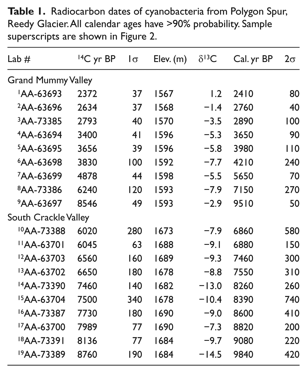
Today, ice abuts Grand Mummy Pond at 1566 m elevation. A narrow, bedrock-constrained valley slopes upward from the pond toward the indistinct Reedy III drift limit (~1680 m elevation) dating to the maximum of the last glaciation (the ‘local’ LGM; Bromley et al., 2010; Mercer, 1968; Todd et al., 2010). Ridges, termed here the Polygon moraines, mark a less extensive former ice position only ~200 m beyond the present-day glacier margin. Lateral moraines associated with this Polygon ice limit are well-preserved on the valley walls, but the terminal ridge is absent. A cluster of large boulders on the valley bottom at ~1590 m elevation may mark the former ice terminus, although the exact position remains uncertain. Three cyanobacteria samples (AA-63694, AA-63695, AA-63699) came from sites distal to the Polygon ice limit, based on projection of the lateral ridges to the valley floor. An additional three (AA-73386, AA-63697, AA-63698) were taken from sites 10–20 m distal to the cluster of large boulders and thus also may be outboard of the same ice-marginal position. The remaining samples (AA-63693, AA-63696, AA-73385) were all from lower elevation, well within the Polygon limit and close to the present-day pond. Despite careful search, we did not find any cyanobacterial mats on the valley floor between 1570 and 1592 m elevation. Nor did we find mats between the elevation of our highest sample and the Reedy III limit.
Dates from Grand Mummy Valley range from ~2400 to 9500 yr BP. Those clearly distal to the Polygon ice limit are ~3700–5700 yr BP and become younger toward the former ice position. The three samples whose precise geographic relationship to the former terminus is less certain range from ~4200 to 9500 yr BP and lack any particular spatial pattern either with elevation or distance from the present ice (Figures 2 and 5). The remaining three samples, all located proximal to the Polygon moraines and at a much lower elevation, are ~2400–2900 yr BP and become progressively younger toward the present-day pond.
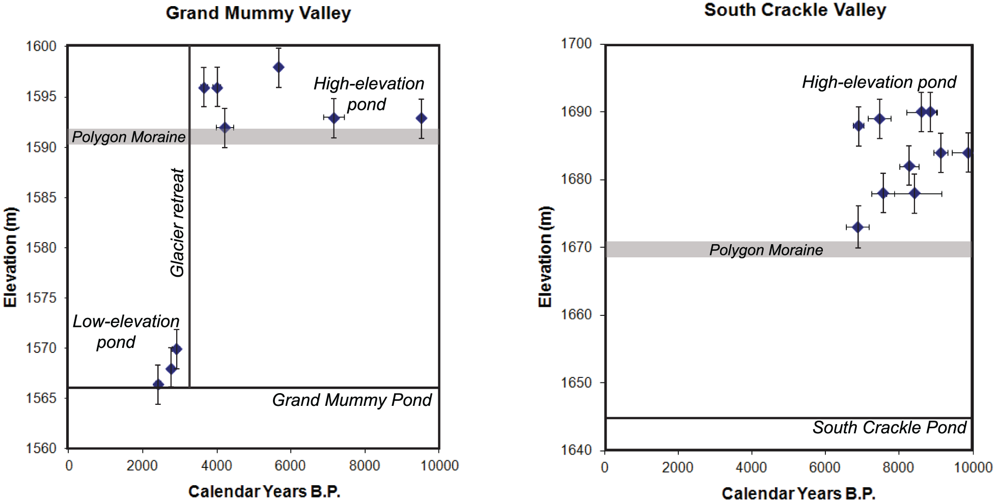
Radiocarbon samples plotted relative to elevation. High-level cyanobacterial samples are from former ice-dammed ponds that existed when ice was thicker than it is at present. This time may have coincided generally with Polygon moraine deposition, although variation in elevation of cyanobacteria samples likely reflects minor oscillation of the ice margin and hence of the pond locations. Late-Holocene recession led to migration of the ponds down the slope toward the present-day glacier. The solid horizontal line on each diagram indicates the present-day pond level. The gray bar indicates the elevation of the Polygon moraine.
Similar deposits occur in South Crackle Valley to the west of Grand Mummy Pond. Here, Crackle Pond is at 1644 m elevation adjacent to the ice margin. The land rises steeply immediately above the pond in a snow-drifted slope and then separates into two gently rising basins – North and South Crackle Valleys. The pale-colored Reedy III drift limit, thought to date to the local LGM, occurs at the far end of South Crackle Valley but its elevation is not well-constrained at present. An indistinct, discontinuous moraine, similar to the one in Grand Mummy Valley and inferred here to belong to the same Polygon ice limit, occurs roughly two-thirds of the distance between the LGM drift limit and the modern pond. Dates from South Crackle Valley range from ~6900 to 9800 yr BP (Figures 2 and 5). All samples were from sites distal to the Polygon moraine and, similar to the older samples at Grand Mummy Pond, lack any particular spatial pattern.
Discussion
To our knowledge, this paper describes the southernmost (86°S) radiocarbon dates yet reported. Although modern cyanobacterial mats were reported at La Gorce Mountains (~87°S) at the head of Scott Glacier (Broady and Weinstein, 1998), dates of ancient mats have not been published previously for areas of the Transantarctic Mountains south of Hatherton Glacier (~80°S; Bockheim et al., 1989), although ancient cyanobacteria have been dated near lakes in the Pensacola Mountains inland of the Weddell Sea (80–84.5°S; Hodgson and Bentley, 2013).
Radiocarbon dates indicate times when sample sites must have been ice free in order for the mats to grow. Thus, dates of cyanobacteria afford minimum ages for deglaciation of the particular spot they occupy. However, at our study site, the geomorphology indicates that the glacier also must have been nearby in order to dam the proglacial ponds in which the cyanobacteria lived. At Grand Mummy Valley, our dates indicate that ice retreated down the slope from the local LGM position to the vicinity of the Polygon ice limit by ~9500 yr BP and dammed a pond that persisted to within 6 m of the same elevation until at least ~3600 yr BP (Figure 6). Since there is no terminal moraine and no evidence that there ever was one, the lake must have been dammed by ice and not by sediment. Samples distal to the Polygon ice limit span ~6000 years and 6 m in elevation. While it is possible that these cyanobacteria reflect growth in a single pond 6 m deep that persisted for ~6000 years, another possibility is that the glacier fluctuated slightly, causing the pond location to vary up and down the slope by a few meters in elevation. Downslope migration of the pond after 3600 yr BP indicates ice retreat from the Polygon moraines. A gap (both temporally and spatially) in our radiocarbon samples likely corresponds to a period of rapid thinning between ~2900 and 3600 yr BP. The gap also could represent the absence of the pond through that time. Based on a date of a cyanobacterial mat 50 cm above the existing pond and <25 m from the present-day ice margin, we infer that the glacier was similar to or less extensive than it is today by at least~2400 yr BP.
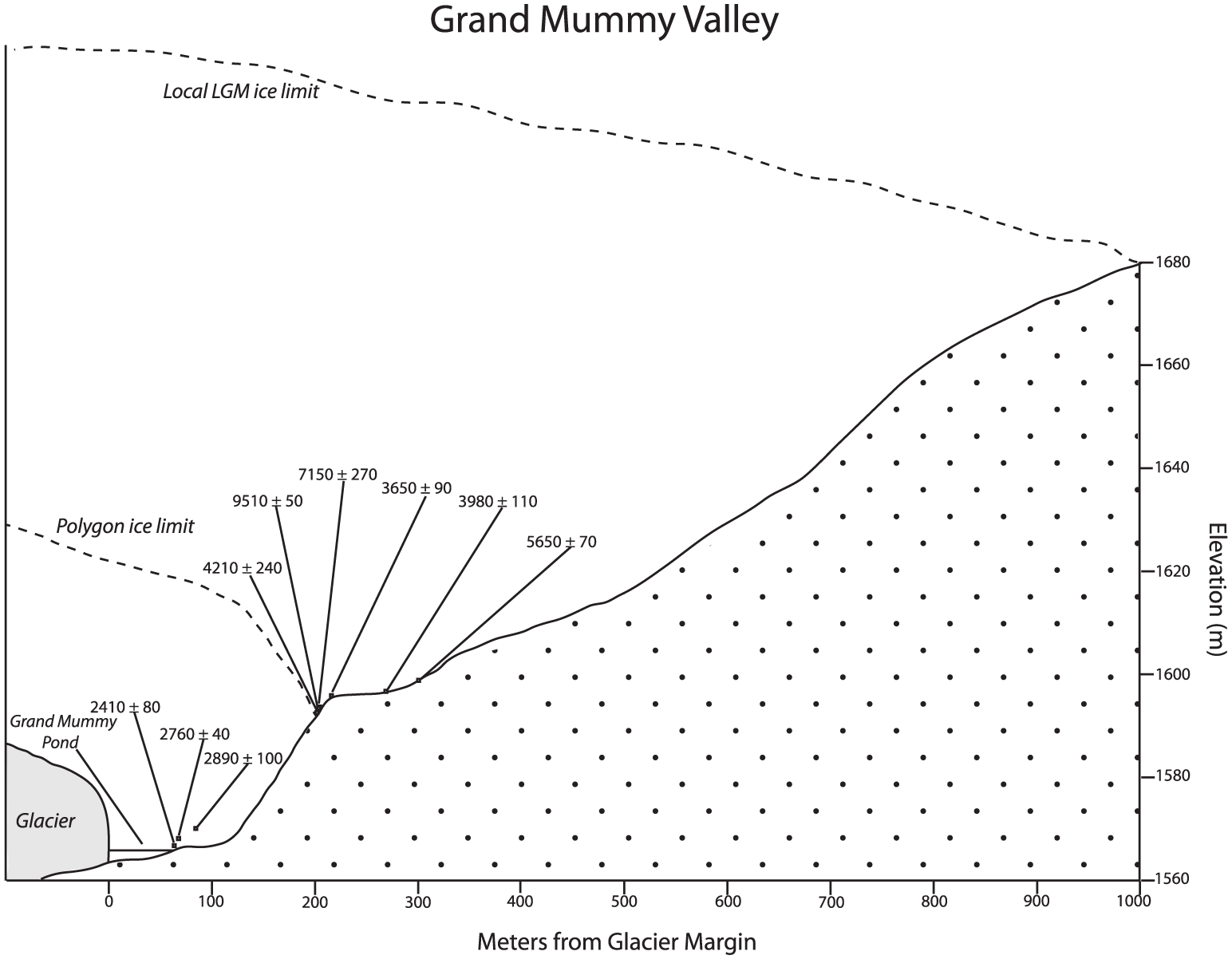
Schematic cross section of Grand Mummy Valley, showing approximate topography and location of dated samples relative to former ice positions mentioned in the text. Ice retreat between ~2900 and 3700 yr BP caused a shift in the location of the ice-marginal pond from nearly 1600 to 1566 m elevation.
We did not find any relict mats younger than 2400 yr BP. As this latter sample was only 50 cm above the pond, it could be that ice and lake levels have been stable over the past 2400 years. An alternative explanation is that water level was lower in the past two millennia and since has risen, covering any relict pond deposits <2400 yr BP. This scenario could come about either by glacial recession and then readvance or by the changes in meltwater input.
The timing of initial deglaciation in South Crackle Valley was similar to that at Grand Mummy Valley. Ice recession from the local maximum position was underway by ~9800 yr BP. As at Grand Mummy Valley, the dated mat samples distal to the Polygon ice limit span a range of elevations, here about 20 m, and ages. Although possible, we think it unlikely that the former pond ever reached a depth of 20 m. Therefore, we suggest that the span of ages reflects an oscillating ice margin with minor readvances and retreats over the course of ~3000 years and that some of the older cyanobacterial samples survived burial by ice. The margin reached the Polygon limit by at least ~6900 yr BP. If one assumes that Grand Mummy and Crackle Lobes have a similar history, then ice in South Crackle Valley remained close to the Polygon moraine several thousand years after the age of our youngest sample (~6900 yr BP). The history of the Crackle Lobe after ice pulled back from the moraine is obscured by a large snowbank.
In summary, the data from Grand Mummy and South Crackle Valleys suggest that retreat from the maximum of the last glaciation was underway by 9500–9800 yr BP. After initial retreat, there was a period of relative stability in the middle Holocene, with the ice maintaining a position (at the Polygon moraines) roughly two-thirds of the distance from the maximum limit to the present-day margin. The ice margin may have undergone minor oscillations up and down the slope in the vicinity of the Polygon ice limit through this time. The more complete record at Grand Mummy Pond suggests a period of renewed thinning between about 2900 and 3700 yr BP. The history of the last two millennia is uncertain, but ice may have receded behind its present-day position and then re-expanded.
Comparison with cosmogenic data
Beryllium-10 surface-exposure age dates of erratic cobbles also bear on the timing of deglaciation at Polygon Spur (Todd et al., 2010). Although none of these samples comes from the exact locations of the radiocarbon sites, a comparison between the two helps to illustrate the overall Holocene history of the ice lobes.
Todd et al. (2010) dated six glacially transported boulders and cobbles associated with the Reedy III limit at Mim’s Spur, located southeast of Pop Valley. Three of these were perched cobbles immediately inboard of the ice-cored glacial maximum moraine, and the remaining three boulders came from the sparse scatter marking the limit farther east. Ages reported in Todd et al. (2010) are revised (Table 2), based on more recent estimates of the 10Be production rate, all of which are substantially lower than the original rate (e.g. Fenton et al., 2011; Goehring et al., 2012; Putnam et al., 2010; Young et al., 2013). These calibrations all derive from lower latitude (the latter three from the northern hemisphere) and altitude than Reedy Glacier, so estimates also depend on the choice of production-rate scaling factor. Weighted mean ages from the six samples range from 9300 yr BP (calibration of Goehring et al., 2012, scaled using Lifton et al., 2005) to 10,500 yr BP (calibration of Fenton et al., 2011, scaled using Lal, 1991). In all cases, the ages spread over ~1500 yr between the youngest estimate, an isolated boulder, and a cluster of four ages from samples close to the ice-cored moraine. Isostatic corrections to these ages would likely increase them <1%, based on relative sea-level estimates from Briggs et al. (2014). Collectively, these results are consistent with the radiocarbon dates from Polygon Spur, indicating that ice was at its maximum level at ~10,000 yr BP and retreated shortly thereafter. However, because the radiocarbon and exposure-age samples come from different locations, and because of the difficulty of relating the data sets to one another in detail, we cannot use this comparison to derive a 10Be production-rate calibration in Antarctica.
Recalculated 10Be exposure ages from local last glacial maximum limit at Mim’s Spur (Todd et al., 2010).

Samples were analyzed against a number of standards at PRIME Lab and LLNL-CAMS. All concentrations shown here have been recalculated to a common basis for comparison, referenced to the 07KNSTD standard.
Ages based on the production rates from Fenton et al. (2011) scaled according to Lal (1991), and Goehring et al. (2012) scaled according to Lifton et al. (2005) are maximum and minimum estimates, respectively, obtained from combinations of scaling factors and relevant production rates available through the CRONUS online calculator (Balco et al., 2008).
Three of the recessional samples from Mim’s and Polygon Spur described and dated in Todd et al. (2010) gave Holocene ages younger than the age of the glacial limit; four others are pre-exposed (apparent ages ~17–150 kyr BP). Recalculation of the three Holocene recessional ages produced revised estimates from 9100 to 5600 yr BP, all of which are consistent with the positions of the radiocarbon samples distal to the Polygon moraines or their equivalent positions on Mim’s Spur.
Holocene outlet-glacier history
Our data indicate rapid thinning and initiation of marginal retreat of the upper part of the Reedy Glacier system at 9500–9800 yr BP. In Grand Mummy Valley, ice reached the Polygon ice limit by 9500 yr BP, a retreat which represents an 85-m elevation drop relative to the local LGM position and a loss of ~75% of the total glacial-interglacial elevation change (Figure 6). If one assumes that the LGM limit was maintained here until ~10,000 yr BP, similar to Mim’s Spur, then initial ice recession was rapid. Such a rapid retreat may account for the apparent lack of cyanobacterial mats between the LGM limit and our highest sample, as cyanobacteria may not have had the opportunity to become well-established on newly deglaciated terrain before the pond location moved downslope. The presence of ice-marginal ponds in the vicinity of the Polygon ice limit for several thousand years in the mid-Holocene suggests that the glacier may have been relatively stable after this initial ice loss. Scatter in the radiocarbon ages near the moraine is attributed to minor fluctuations of the ice margin and hence of the pond positions over time. However, we cannot exclude the possibility that the mats grew in single, large, long-lived ponds with an ice margin fixed at the Polygon limit for several thousand years. In this case, scatter in the ages could be because of the minor changes in water level from meltwater variations. For example, farther north, the water-level variations in the Pensacola Mountains (Hodgson and Bentley, 2013) were interpreted in terms of the changes in meltwater discharge, and large lakes in the Dry Valleys region (78°S) also have been reported to undergo significant water-level changes because of meltwater availability (Hall et al., 2010). However, both these locations are warmer with more surface water than at Polygon Spur.
We infer that retreat from the Polygon ice limit occurred after 3700 but before 2900 yr BP in Grand Mummy Valley, when the pond dropped from roughly 1596 to 1570 m elevation. Since 2400 yr BP, the glacier must have been at or behind its present-day position.
Holocene fluctuations of Reedy Glacier, and most likely other southern Transantarctic Mountains outlet glaciers, have resulted from a balance between upstream propagation of the effect of WAIS thinning following the LGM and local thickening of the EAIS and alpine tributary glaciers because of increased accumulation (Hall et al., 2015). Deglaciation began as early as ~13,000–14,000 yr BP near the mouth of Reedy Glacier but not until ~11,000 yr BP in the Caloplaca Hills, located mid-way up Reedy Glacier (Todd et al., 2010). Both the radiocarbon and cosmogenic data indicate that ice may not have attained its maximum level at Polygon Spur until a thousand years later, in the early Holocene. This late maximum and consequent delayed deglaciation resulted at least in part from a time lag in the propagation of thinning from the mouth. However, the key factor that likely contributed to this pattern of ice fluctuations along upper Reedy Glacier was an increase in accumulation which occurred synchronously with rising air temperatures over Antarctica (WAIS Divide Project Members, 2013). The record at Polygon Spur likely reflects the interplay between these two mechanisms. If our inferred middle Holocene stillstand is correct, then it implies that these two factors were approximately in balance for much of the Holocene at the edge of the EAIS plateau. Given that the mid-Holocene was a period of rapid grounding-line recession in the Ross Sea Embayment (Conway et al., 1999) and thinning at the mouth of Reedy Glacier (Todd et al., 2010), increased net accumulation within the upper parts of the drainage basin must have offset the effects of mechanical down draw along upper Reedy Glacier. Although there are no independent records near upper Reedy Glacier, such a period of increased accumulation is generally consistent with existing ice-core and ice-radar records from both West and East Antarctica (Monnin et al., 2004; Neumann et al., 2008; WAIS Divide Project Members, 2013). For example, Neumann et al. (2008) suggested that accumulation in central West Antarctica was 30% greater than at present between 3000 and 5000 yr BP, a result generally confirmed by the new WAIS Divide ice-core record (Buizert et al., 2014). Thinning of upper Reedy Glacier at some point after 3700 yr BP may indicate a time when loss because of glacier mechanical adjustment was no longer compensated by additional accumulation.
This work, along with that of previous studies (i.e. Hall et al., 2015; Todd et al., 2010), points to the critical necessity of understanding the geographical context of glacial records in the Transantarctic Mountains, as well as the underlying reasons for outlet-glacier fluctuations. For decades, researchers have assumed that the ‘fresh’, unweathered drift deposits in the Transantarctic Mountains all date to the global LGM (i.e. Bromley et al., 2010; Denton et al., 1989). This assumption led to a variety of glacier reconstructions, including longitudinal profiles of outlet glaciers and whole ice-sheet models, based on meeting those drift limits as targets. We find with increased dating control that although those fresh deposits do date from the last glaciation, the precise timing of the maximum varies considerably along the outlet glaciers, causing those previous reconstructions to be oversimplifications. Future outlet-glacier reconstructions, as well as ice-sheet models using glacial geologic data as targets, must take into account the time-transgressive nature of not only glacial maxima but also ice recession in the Transantarctic Mountains.
Conclusion
We produced the first radiocarbon record of former ice fluctuations from the southern Transantarctic Mountains. Deglaciation at Polygon Spur was underway by the early Holocene (~9500 yr BP) and had receded to a position roughly two-thirds the distance from the local LGM limit to the present-day margin shortly after that time. During a period of relative stability in the mid-Holocene, the glacier produced moraines in several valleys. Renewed thinning began after 3700 yr BP, with ice reaching its present-day level by 2400 yr BP. The glacier has remained at or behind its present position since that time. These Holocene fluctuations of upper Reedy Glacier likely reflect the interplay of the upstream propagation of mechanical thinning events at the glacier mouth and local, climate-driven accumulation changes.
Footnotes
Acknowledgements
M Conway and C Todd assisted in the field. The authors thank two reviewers for thorough comments.
Funding
This research was supported by the Division of Polar Programs of the National Science Foundation (grant number OPP-0229034).