






Abstract
Islands present significant technological and ecological challenges for long-term human settlement, with archaeological investigations of islands globally able to shed light on the adaptive plasticity of cultural groups to changing climatic regimes. The Massim islands of eastern New Guinea significantly reduced in size throughout the Holocene (⩽11.7 kya), providing a unique opportunity to investigate the long-term adaptive capabilities of humans to changing island ecosystems. Here, we report a 2500-2300 year cultural sequence on Nimowa Island in the Louisiade Archipelago of the Massim region which began with the arrival of a late Lapita population during initial beachfront development. Sediment analyses indicate earlier settlement on the island would not have been possible as the coastline was unstable until near-modern sea levels were reached. The island was abandoned from 1290 to 530 cal. BP during a period of unusually dry conditions (‘Medieval Climate Anomaly’) and probable freshwater shortages. Re-settlement coincided with wetter climatic conditions (‘Little Ice Age’), associated with the establishment of large villages, the earliest expression of local pottery traditions and the onset of large-scale regional exchange networks. Import of non-local obsidian reflects two pulses of interaction followed by periods of increased isolation. With the absence of high-quality lithic resources, shell, coral and bone were used as a locally available alternative for tool production. Increased cyclone frequency from ~500 cal. BP greatly increased beach volume in the island and coastal New Guinea, which facilitated the movement of populations onto smaller islands. A late prehistoric shift in settlement patterns had a profound impact on regional social dynamics.
Introduction
The sustained settlement of islands by humans is dependent on the development of technologies and cultural systems which buffer against the challenges of living in relatively impoverished ecosystems. Although our species is sensitive to changes in both ecology and climate, the adaptive plasticity afforded by cultural systems has enabled populations to span the globe and migrate into a range of otherwise marginal environments (Grove, 2015). Modern humans made the first major sea crossings to colonize the New Guinea-Australian continent (Sahul) between 65,000 and 50,000 BP, and the nearby islands of the Bismarck Archipelago by 43,000 BP (Clarkson et al., 2017; Summerhayes et al., 2017) (Figure 1a). However, the remote islands of the Pacific Ocean further to the east and north were not colonized until 3500–3000 BP because they presented significant ecological and navigational challenges beyond the technological and adaptive capabilities of earlier populations (Bedford et al., 2006; Carson, 2014). Behavioural innovations developed by agriculturalist seafarers in Island Southeast Asia, defined in Oceania as the Lapita Cultural Complex, facilitated the large-scale movement of people into New Guinea and, for the first time, out into the remote Pacific islands.
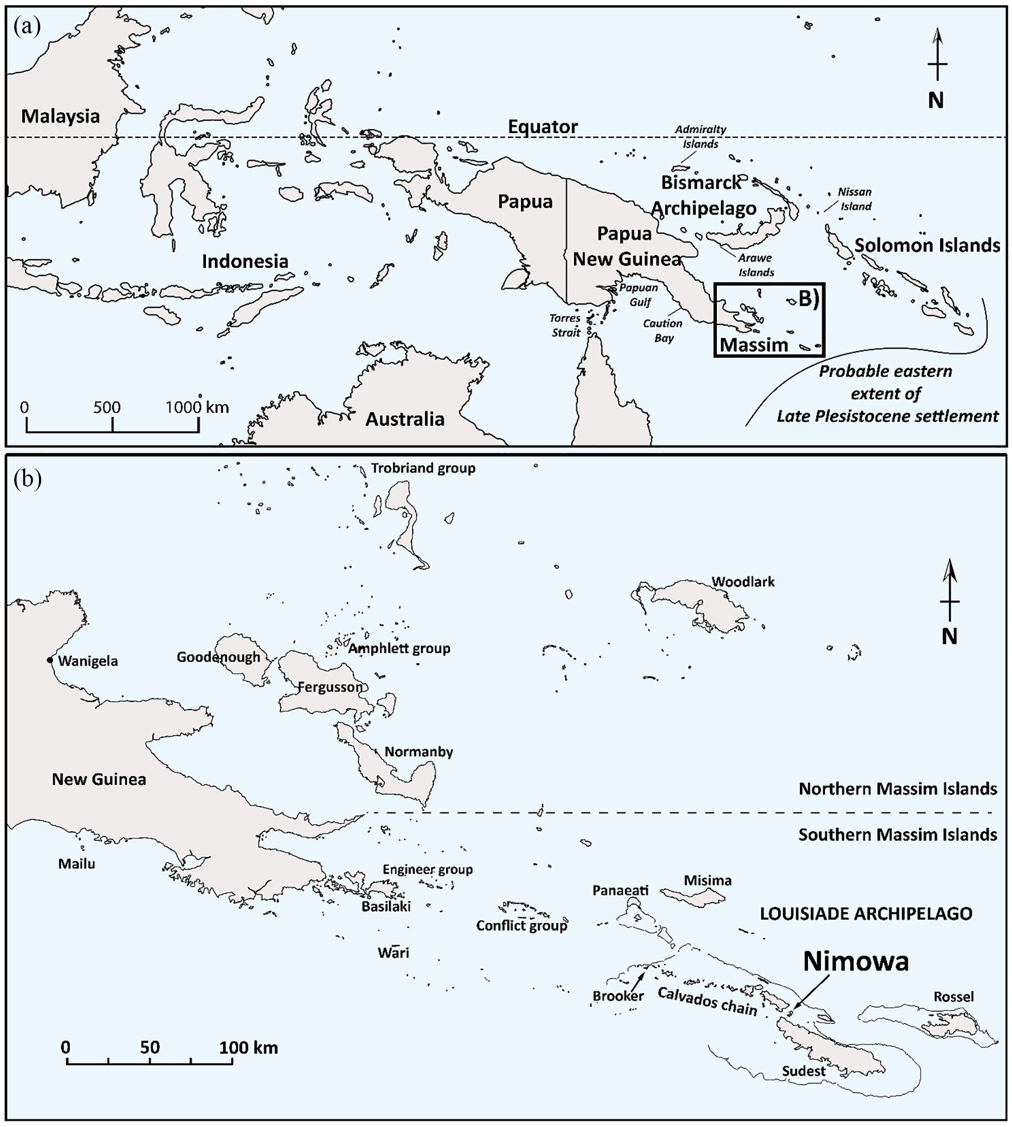
(a) Map of the Indo-Pacific region showing the location of the Massim islands. (b) The location of Nimowa Island within the Massim. Probable eastern extent of late-Pleistocene settlement in (a) is based on the location of known sites of this antiquity and the inter-visibility between islands.
Throughout New Guinea and the Bismarck Archipelago, Lapita settlers would have encountered populations who had occupied the region for millennia prior to their arrival. The Massim islands of eastern Papua New Guinea were likely also colonized in the late Pleistocene (>11.7 kya) when many islands formed an extension of the Sahul continent or were considerably larger (Shaw, 2017) (Figure 1b). However, following the Last Glacial Maximum (LGM, ~23–19 kya), global sea levels have risen by ~134 m, reducing the Massim islands to a fraction of their former size (Lambeck et al., 2014). The Louisiade Archipelago comprised only ~11 islands during the LGM, with the largest (defined here as the Greater Calvados Island) estimated to have been around 8000 km2 in area. Today, there are around 220 islands and islets in the archipelago. Many of the smaller islands (<10 km2) in this region would have presented challenges for settlement similar to those of the remote Pacific because of their relative isolation and unstable coastlines. Low-lying islands (<200 m a.s.l.) were also severely impacted by fluctuations in climatic conditions, particularly rainfall, and are constantly at risk of drought. These unique conditions allow an assessment of the long-term adaptive plasticity of human cultural systems prior to, during and after the arrival of Lapita populations.
Here, we present findings from archaeological investigations at the Malakai site on Nimowa Island, a small island (3.5 km2) in the Louisiade Archipelago located within the former footprint of the Greater Calvados Island. Systematic excavation and radiocarbon dating demonstrate that the settlement of Nimowa commenced by 2490–2290 cal. BP with the arrival of a late Lapita population during the initial stages of beachfront development. Two major phases of the settlement are separated by ~800 years when the site, and probably the island, was abandoned during a prolonged period of drier climatic conditions. Re-settlement occurred by 530–430 cal. BP during a time when populations throughout the Massim and in coastal New Guinea had modified their settlement patterns to access maritime trade routes and to protect themselves against seasonal drought (Allen, 2017; Bickler, 2006; Egloff, 1978; Shaw, 2016). We combine geomorphological, sediment and material culture analyses to provide the highest resolution record for beach development and associated human settlement in the Massim. We argue that both social and climatic pressures influenced island settlement patterns over the last 2500 years. By comparing the results against regional archaeological and palaeo-ecological records, the excavated findings contribute to models for adaptive plasticity of island populations in response to fluctuating climatic conditions in New Guinea and the Pacific region.
Climatic drivers for late-Holocene human settlement
The climate in the Indo-Pacific region throughout the late Holocene (⩽4200 BP) was relatively stable compared with the preceding millennia which facilitated the settlement of small islands. Coral reef systems began forming in tropical latitudes during the middle Holocene (8200–4200 BP), but their volume and biodiversity substantially increased within the last 2500–2000 years as near-modern sea levels were reached following a 1–3 m drawdown from a mid-Holocene peak in sea level (henceforth, the ‘high sea stand’) (Dickinson, 2004; Gosden and Webb, 1994; Lambeck et al., 2014; Weisler et al., 2012). Therefore, island size and ecology throughout much of the late Holocene would have been broadly comparable to today. However, an increase in the frequency and strength of El-Nino Southern Oscillation (ENSO) events since the middle Holocene resulted in significant annual/decadal fluctuations in rainfall, which affected freshwater availability and the feasibility of long-term island settlement (Barr et al., 2019; Field and Lape, 2010; Fitzpatrick et al., 2016; Gagan et al., 2004). Protracted periods of drier ENSO-forced conditions prevailed from 2500 to 1700 BP – up to twice the amplitude of the 1997–1998 ENSO event, the strongest in recorded history – which caused widespread drought and famine across the Western Pacific (McGregor and Gagan, 2004; McPhaden, 1999).
Two notable periods of climatic fluctuation within the last 1250 years have been correlated with the abandonment of small islands and behavioural adaptations in the Pacific region (Clark and Reepmeyer, 2012; Kirch and Yen, 1982; Nunn, 2000). The Medieval Climate Anomaly (MCA; ~1250–700 BP) was a period of relatively warm and dry conditions compared with previous centuries, with temperatures in tropical latitudes similar to the modern climate (Barr et al., 2019). An increase in ENSO events throughout the MCA resulted in seasonal droughts, irregular rainfall patterns and fewer tropical cyclones (Nott and Forsyth, 2012). The Little Ice Age (LIA; ~550–100 BP) was a subsequent period of relatively cooler air temperatures, with variable but generally wetter conditions in the Western Pacific region, coupled with fewer ENSO events (Griffiths et al., 2016; Nunn, 2007; Yan et al., 2011). On Misima Island, analyses of fossil coral cores confirm this pattern for the Massim island region (Hereid et al., 2013). At the transition between the MCA and LIA (~700–550 BP), both sea surface temperatures and sea levels fell rapidly, and cyclone activity increased, which would have been disruptive to the established coastal settlement and further population dispersals in the Pacific region (Nunn, 2007).
Contextualizing late-Holocene settlement of the Massim islands
The earliest Lapita presence in New Guinea region has been documented in the Bismarck Archipelago from 3300 to 3200 BP, during a period of less frequent tropical cyclones (Kirch, 2001; Nott and Forsyth, 2012; Summerhayes et al., 2010). Evidence for the settlement of small islands in the millennia prior to Lapita arrival (4300–3300 BP) is scarce due to low population densities and coastal preservation. However, on several island groups (Arawe, Admiralties, Garua, Green, Torres Strait), settlement of this antiquity began in low-energy lagoon environments as soon as coastal fringes had developed (David et al., 2004; Gosden et al., 1994; Kennedy, 1983; Spriggs, 1991) (Figure 1a). These archaeological records indicate relatively rapid adaption to developing coastal landscapes and provide a framework for more detailed models of island settlement.
The Lapita settlement of many small islands in the New Guinea region began with stilt houses over shallow lagoons during the early stages of coastal progradation following the mid-Holocene high sea stand (Kirch, 2001). These early sites are recognized by the deposition, for the first time, of pottery and translocated domestic fauna (pig, dog, chicken) in pristine beach sands, with increased quantities of imported obsidian (Summerhayes, 2007). Lapita migrations into remote Island Melanesia occurred from ~3000 BP, as well as dispersals south into the Massim and along the New Guinea coastline around the same time (David et al., 2011; Negishi and Ono, 2009; Petchey et al., 2014; Sheppard et al., 2015; Skelly and David, 2017). What defines Lapita in the archaeological record following its initial spread is still debated (Spriggs, 2003). In the New Guinea islands, there is continuity in coastal settlement and pottery production through to 2400–2200 BP, with long-distance inter-island communication networks maintained over this time. However, the number of pottery production centres, extent of inter-island obsidian transfer, the presence of dentate-stamped motifs and range of pottery vessel forms gradually decreased (David et al., 2019; McNiven et al., 2012; Summerhayes, 2007). The spatial extent of Lapita social networks, collectively spanning over 5000 km, was not seen again in a prehistoric context.
Over the last 2200 years, there was an increase in the regional expression of social identities, which although clearly descend from Lapita culture, are distinct from it (David et al., 2012; Summerhayes and Allen, 2007). On the south coast of New Guinea, intensive settlement from this time is associated with shell impressed pottery and a range of shell and stone tools/ornaments manufactured at coastal settlements identified across a ~700-km range (Allen, 2010). Plainware pottery of this age is also known in the Massim, but it is currently unclear how social groups in this region relate to those on the south coast (Chynoweth et al., in press; Negishi and Ono, 2009). Although obsidian from the Massim was transferred along the south coast at this time suggesting some degree of contact, this has yielded limited insight into the cultural affiliations of the Massim populations involved (Mialanes et al., 2016). From ~1200 to 1000 BP, many settlements along the south coast of New Guinea which had been occupied for up to a millennium were abandoned, with a breakdown in maritime supply lines also evident (Allen, 1972; Swadling, 1981; Vanderwal, 1973). Changing settlement patterns in response to increased aridity (during the MCA) has been argued as a significant driver for such a shift (Allen, 2010). In the Massim, by 1200 BP large megalithic structures had been established as part of a regional system of social organization which spanned the northern islands (Bickler, 2006). Within the last 1000 years, however, increasingly localized and idiosyncratic spheres of cultural development became apparent throughout coastal and island New Guinea. A resurgence of long-distance trade subsequently occurred by 500 BP when a series of socially regulated coastal and island exchange networks emerged (e.g. Hiri, Kula) (Irwin et al., 2019; Lilley, 2004; Skelly and David, 2017).
Nimowa Island and the Malakai site
Nimowa is a small crescent-shaped schistose island in the southern Massim region, situated ~290 km from the New Guinea mainland at the eastern end of the Calvados Island group – a 106-km chain of 70 islands within the Louisiade Archipelago (Figure 2a and Figure S1a, available online). Nimowa is ⩽4 km from the larger islands of Sudest (812 km2) and Panatinani (77 km2) and is located within an expansive lagoon marking the former Pleistocene coastline (Shaw, 2017). The shallow lagoon provides relatively calm conditions for sailing between the Calvados islands and is one of the most biodiverse marine environments in the world (Allen et al., 2003). A steep thickly vegetated ridge (130 m a.s.l.) runs the length of Nimowa, separating the leeward (western) and windward (eastern) sides of the island. The eastern coastline is steep, narrow and heavily eroded, whereas a large sheltered bay spans most of the western side of the island, within which large low-lying beach flats have developed.
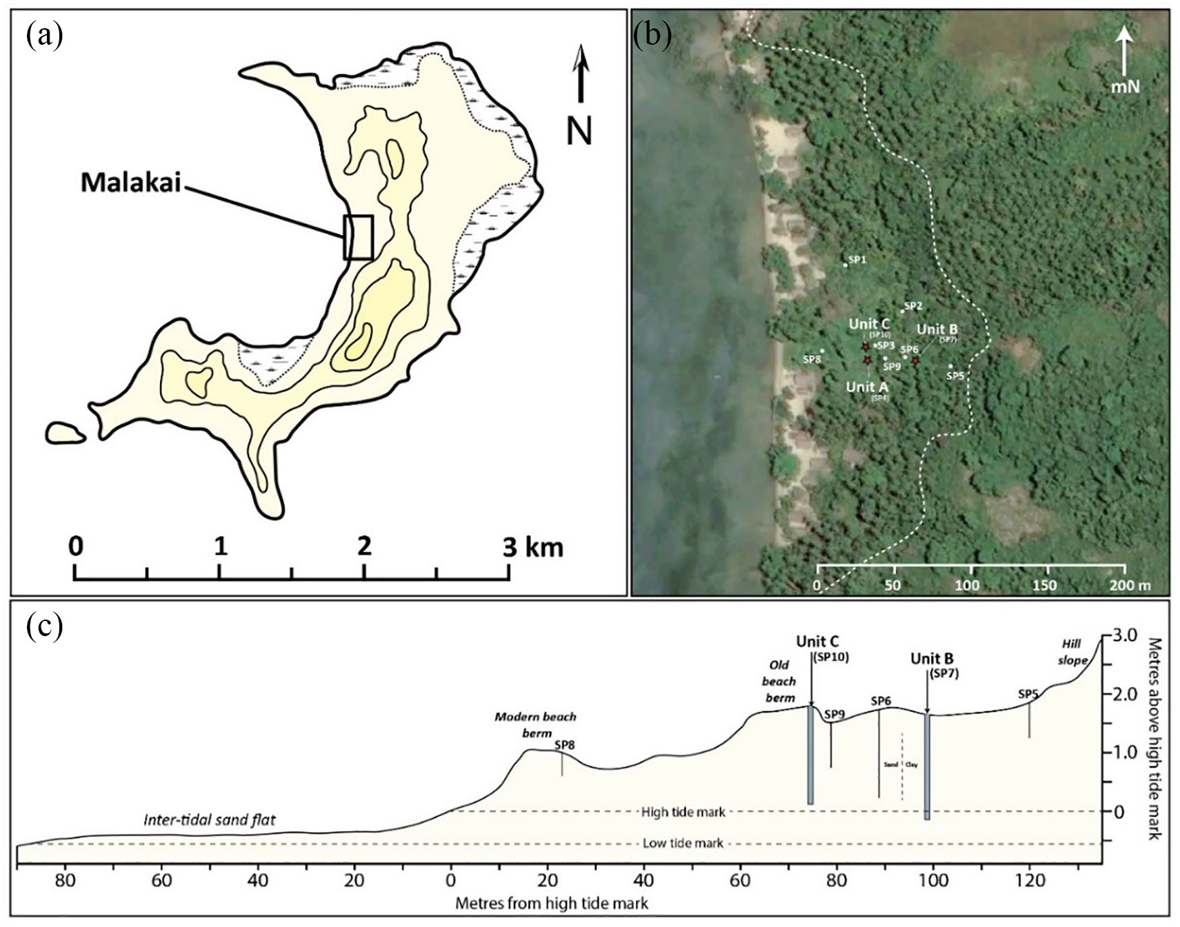
Map of Nimowa Island and the Malakai site. (a) A 40-m contour topographic map of Nimowa, with location of Malakai and current extent of mangrove swamp marked. (b) Satellite image of Malakai with the locations of spade pits and Units A–C shown, with the approximate base of the hill slope indicated by dashed line. (c) Elevation profile of the Malakai beach showing the distribution and depth of spade pits and excavation units. Satellite imagery obtained from Google Earth.
The Malakai site is situated in this large crescent-shaped bay (Figure 2b and Figure S1b–d, available online). The beach flat here extends 120 m from the lagoon to the base of the central ridgeline and up to 1.85 m above sea level. There is no evidence of recent coastal uplift on Nimowa, and based on the modelled sea-level drawdown following the mid-Holocene high stand, it was anticipated that a beach deposit of this elevation would have only formed within the last two to three millennia (Dickinson, 2003). Ongoing progradation within the shallow bay had also formed a 90-m inter-tidal sand flat in front of the modern beachfront. Surface survey and spade pitting (n = 10) identified a marked increase in the density of material cultural beginning ~60 m inland on top of and behind a palaeo-beach ridge/berm, which had evidently been the focus of late prehistoric settlement. A transition from sand to clay substrate 90–95 m inland marked the back of the beach deposit and the former location of a swamp, now infilled and planted with banana trees to facilitate drainage (Figure 2c). Heavily weathered late prehistoric–historic pottery (<200 BP) was found in unconsolidated sands closer to the lagoon; consistent with a rapidly prograding shoreline.
Three square metre units were systematically excavated at the back of the Malakai beach flat. Unit A (1 m2) was excavated in 2012, but because of time constraints the base of the cultural deposit was not reached. The results of this preliminary investigation are presented in Shaw and Dickinson (2017), with these findings incorporated into the analyses presented here. Two 1 m2 units (B and C) were subsequently excavated in 2017 to establish a full cultural sequence and are the focus of this paper. The units were placed 99 and 74 m inland, respectively, with Unit C on the palaeo-beach berm and Unit B on the infilled swamp near the base of the hill (Figure S1f–g, available online).
Stratigraphy and chronology
The sedimentary deposit in the excavated units was clearly stratified but varied due to the different geomorphological contexts. Layers were identified based on colour and particle size, with cultural horizons defined by radiocarbon dating and material culture. In total, 13 radiocarbon dates on unidentified charcoal and anthropogenically modified marine shell of known species/genera collected in situ provide a well-constrained chronology and establish Malakai as the most robustly dated site in the Massim region (Figure 3 and Figure S2, available online). Dates were calibrated using OxCal 4.3 and are presented in text as the highest probability 95.4% ranges rounded to the nearest 10 years. Full details and calibrated ranges are provided in Table S1 (available online). Although no island-specific ΔR value for marine shell dates was available for Nimowa Island, the western Massim island correction of 38 ± 14 was preferred over a 0 ± 0 correction (Petchey and Ulm, 2012). Dates obtained from Unit A (lab codes italicized) are correlated with the Unit C sequence as the sedimentary layers between these units are identical.
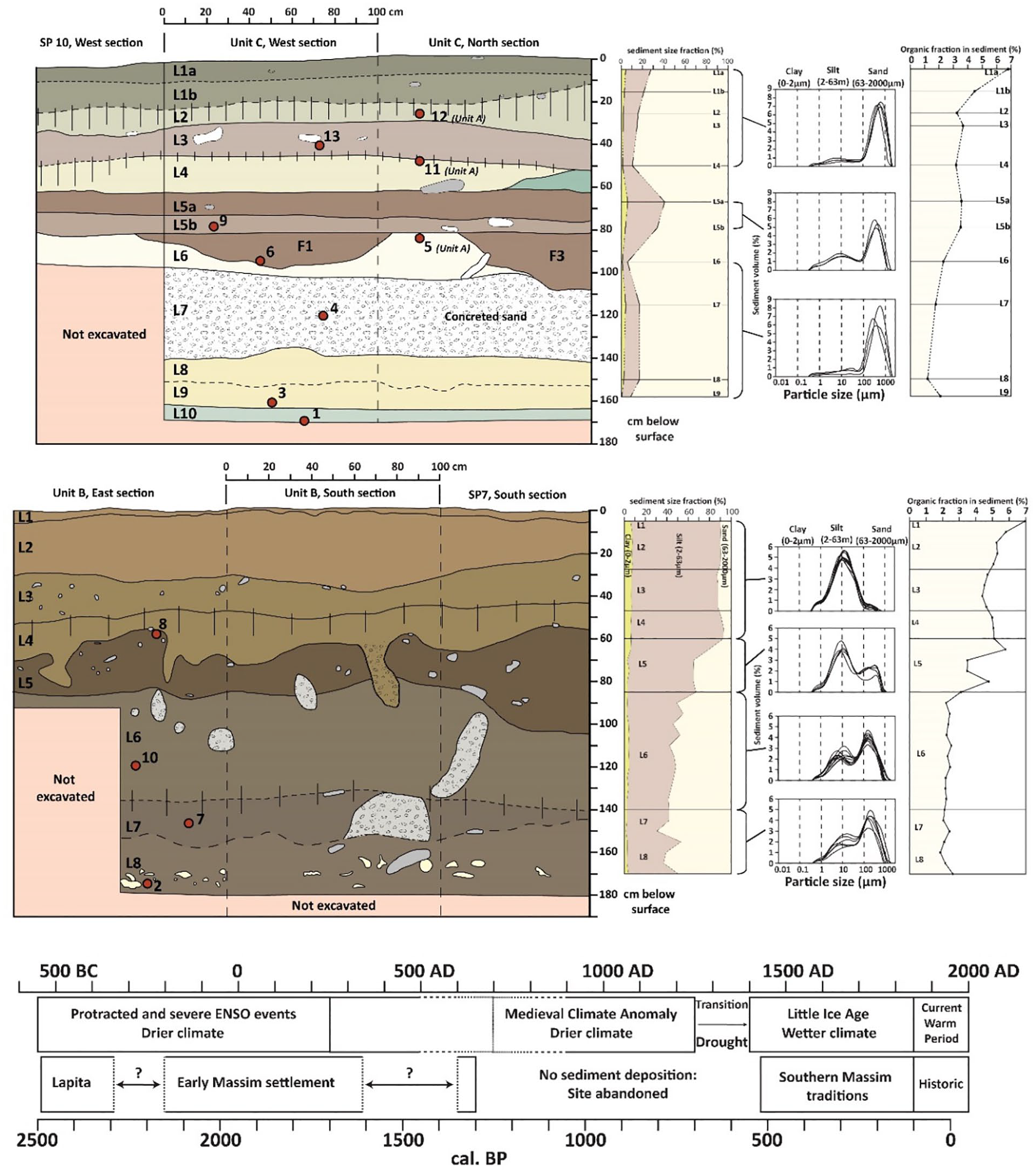
Stratigraphic profile drawings, sediment particle and organic analyses of Units C–B, and a chronological summary relative to major periods of climatic change. The layers and the location of the dated charcoal/shell samples (red dots) are shown, with the numbers corresponding to the dates in Table S1 (available online). AMS dates from Unit A are included in the Unit C drawing to demonstrate their location in the sequence as the layers are the same. Refer to the text for climatic period references.
Unit C
Unit C was excavated to a depth of 169 cm, and 10 layers were identified (Figure 3, and Figure S3 and Table S2, available online). Excavation was halted at this depth due to rapid inundation of the water table. The sediment throughout the deposit was alkaline (pH 8.5–9), providing excellent conditions for the preservation of faunal material (bone and shell) (Table S4, available online). Layer 10, dating to 2490–2290 cal. BP (Beta-479380), was a grey stained coarse calcareous sand with large coral detritus, containing few pottery sherds and shell artefacts. Minimal wear on the pottery suggests that the material culture was deposited when the area was still underwater in a shallow lagoon environment. Layers 9–7 comprised a coarse white calcareous sand with a similar component of coral detritus. A date of 1990–1800 cal. BP (Beta-479379) was obtained from Layer 9, and a date of 1820–1610 cal. BP (Beta-479378) was obtained from midway through Layer 7. Layer 7 had been indurated into a 40-cm-thick beachrock deposit, formed by the relatively rapid cementing of carbonate-rich minerals in the inter-tidal zone (Mauz et al., 2015). Heavily worn pottery and obsidian from these layers confirm cultural material was exposed to a high-energy water environment prior to deposition. Faunal bone from these layers was observed in trace amounts but was not able to be systematically collected due to the cemented sand and rapidly filling water table. A date of 1350–1290 cal. BP (ANU-32536: charcoal) provides a terminal age for the deposition of Layer 6, a coarse pale brown beach sand which contained no cultural material except charcoal. Shaw and Dickinson (2017) had erroneously attributed this date to Layer 5. Settlement from 2490 to 1290 cal. BP appears to have been low density based on the small volume of deposited material culture.
There was a clear increase in the intensity of beach settlement associated with the deposition of Layer 5a/b. Dated to 500–310 cal. BP (Beta-479377), the layer comprised a greyish brown sand with a notably higher silt component (30–35%) marking a consolidated palaeosol and well-defined habitation surface. Postholes and shallow pits, dated to 530–430 cal. BP (Beta-487396), had been cut at least 40 cm from Layer 5b into the underlying sand and beachrock (Layers 6 and 7), providing the earliest age for this cultural deposit (Figure S4, available online). Dense concentrations of large, unworn pottery sherds indicate settlement at this time was on a well-developed beach ridge well above the high tide mark. Heavily worn pottery with sand concretions were clearly intrusive from Layer 7, having been translocated in displaced posthole fill. At least 800 years had elapsed between the deposition of Layers 5 and 6. Layers 4–2 had been deposited relatively rapidly with three charcoal samples dated to 470–130, 320–140 and 290–0 cal. BP (ANU-33532, ANU-33529, Beta-479376). Layer 1a-b was a dark grey-brown sand which formed a defined habitation surface, as did Layer 3. Layers 4 and 2 were deposited during storm tidal surges but no break in settlement is indicated. A base fragment from a green wine bottle in Layer 1a, formed using a three-piece cup-bottom mould, was relatively dated to AD 1860–1890 (~90–60 BP) (Toulouse, 1969). A conservative estimate of <150 BP is attributed to this layer.
Unit B
Unit B was excavated to a depth of 181 cm, and eight layers were identified (Figure 3, and Figure S3 and Table S3, available online). Layers 8–6 were alkaline (pH 9) with Layers 5–1 trending from neutral to moderately acidic (pH 7–5.5), reflecting a gradual transition from sand to clay (Table S4, available online). Layer 8, dated to 2150–1940 cal. BP (Beta-479375), was a dark greyish brown coarse silty sand containing dense marine shell midden refuse, with few pottery sherds and obsidian pieces. The overlying Layer 7 was dated to 530–430 cal. BP (Beta-487398) and consisted of a greyish brown silty sand. Both early (>1610 BP) and late (<530 BP) style pottery was found in this layer, but larger shells clearly derived from the underlying midden, indicating ~1600 years had elapsed between the deposition of these layers. An erosive event is not likely as no pottery spanning the intervening period (1610–530 cal. BP) was recovered, and the diffuse layer boundary indicates in situ settling. Layer 6, dated to 460–280 cal. BP (Beta-487397), was an unconsolidated olive brown sandy silt with several large infilled crabholes. Layer 5, dated to 530–430 cal. BP (Beta-479374), comprised a brown clay identified as a palaeosol due to its high organic and silt content, which also contained most of the pottery, faunal bone and obsidian (Figure S5, available online). As the date from Layer 6 was later than the identical dates from Layers 5 and 7 (420 ± 30 BP), it is possible that charcoal had been translocated downward from Layer 4 via a crabhole. In any case, the dates indicate an age of no more than 530 years for the deposition of these layers, which is confirmed by the presence of the late prehistoric Southern Massim pottery tradition. A metre of sediment had therefore built up within a century, consistent with the timing of rapid sand build-up in Unit C. Layers 3–1 define multiple phases of culturally sterile clayey silt clearly washed down from the adjacent hillside and must have also accumulated sometime within the last 460–280 years.
Permanent structures associated with island re-settlement
Anthropogenic modifications of the culturally sterile beach surface (Layer 6) in Unit C and the adjoining spade pit (SP10) indicate permanent structures were built during re-settlement of the island (Figure S4, available online). A large posthole (F6, Ø = 40 cm) had been dug ~39 cm into Layers 6–7 from Layer 5b and contained eight unmodified schistose cobbles of local origin (20–7 cm in length) which were likely used to brace a substantial weight-bearing post of a raised structure. Two smaller postholes (F4–5: Ø = 10 cm) may have been part of the same structure. Three infilled depressions (F1–3) were situated around the postholes, with F3 cutting into the Layer 7 beachrock, the function of which is unknown as no ash or material culture was recovered. Feature 1 may have resulted from erosive water rilling along a roof drip line.
Punctuated timing of beach formation at Malakai
The development of the Malakai beach over the last 2500–2300 years reflects changes in climatic conditions and is outlined in Figure 4.
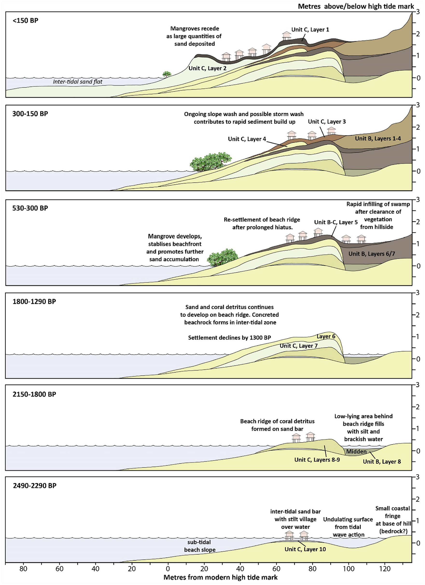
Geomorphological history of the Malakai beachfront over the last 2500–2300 years in relation to human settlement. Geomorphological reconstruction based on recorded sedimentary layers in excavation, 95.4% radiocarbon date ranges, recovered material culture, exploited shellfish, particle size and loss-on-ignition analyses, tidal fluctuations and position of the water table.
Initial beach formation (⩾2490–2290 BP)
A 1- to 2-m drop in sea level 2500–2000 years ago following the mid-Holocene high stand exposed the reef around the island to wave action. This drawdown in combination with prevailing southeast winds and strong sea currents likely broke up reef detritus and deposited it around the island (Unit C, Layer 10). The presence of coarse coral detritus and only minor water rolling on the pottery indicates that the settlement of Nimowa began when the developing beach was still underwater. Offshore formation of beach ridges is common on tropical islands and was a desirable location for prehistoric settlement (Dickinson, 2014). The base of Unit B was deeper than Unit C (see Figure 2c) but contained cultural material ~300 years more recent (2490–2290 cal. BP in Unit C and 2150–1940 cal. BP in Unit B). Wave refraction off the exposed rocky coast may have scoured out the sand creating a sand bar where people first settled, with the material evidence and location suggesting a stilt village was positioned in the inter-tidal zone. Certainly, the position of the bay would have provided a low-energy marine environment conducive for inter-tidal stilt settlement. Sediment trapped around the stilts along with deposition from human activity, as indicated by the grey stained sand, would have further contributed to build-up of sand. The low density of material culture deposited during initial settlement was likely because of both the shallow marine environment and only a small resident population. Gosden and Webb (1994) noted similar processes contributed to sediment accumulation on the Arawe Islands where beach settlement has been identified from 4300–4000 BP, with increased sedimentation from 3000 BP with the arrival of a Lapita population (see also Specht et al., 2016).
Development of the beach ridge and swamp (2150–1290 cal. BP)
A swamp had developed between the sand bar and island sometime after human settlement commenced. In Unit B, a lack of clay together with a consistent organic (~2%) and silt (~40%) component throughout Layers 6–8 indicates deposition of shell midden at 2150–1940 cal. BP occurred before the swamp was isolated from the lagoon (Figures 3 and 4). Sometime prior to 1820–1610 cal. BP, however, sand building up within the Ghyben-Herzberg salt–freshwater interface (Unit C, Layer 7) was cemented and capped the sandbar against which further progradation occurred. The formation of a beach ridge in front of the swamp protected it from tidal action and likely contributed to the lack of sand accumulating in Unit B between 2150–1940 BP and 530–430 cal. BP. As there is no evidence for an eroded surface in Unit B, the immediate area must have been waterlogged throughout this period, with little or no deposition of sediment from clearance of the adjacent hillside.
Cessation of beach ridge development (1290–530 cal. BP)
Sediment deposition on the beach ridge declined and eventually ceased by 1350–1290 cal. BP, as indicated by the substantive chronological gap between Layers 5 and 6 (Unit C). The clean beach sand in Layer 6 was not encountered in Unit B, suggesting it was deposited via low-energy waves which did not reach the back of the beach. A lack of beach ridge formation has similarly been identified at several beaches in far north Queensland (Australia) over this time, and has been attributed to smaller and less frequent tropical cyclones during the MCA (Nott and Forsyth, 2012). Storm tidal surges during the MCA were smaller in magnitude and did not have the energy required to deposit large volumes of sand across established beach ridges. Tropical cyclones in the Massim islands typically track across the Coral Sea to north Queensland, so the same process likely contributed to a lack of sand deposition at Malakai between 1290 and 530 cal. BP. An absence of material culture accumulation over this same period indicates people had also left Nimowa and perhaps moved to the nearby larger and higher islands due to decreased frequencies of rainfall affecting freshwater availability.
Rapid beach progradation (⩽530 cal. BP)
A significant quantity of sand was deposited across the beach berm (Unit C, Layers 1–5) and rapidly filled up the swamp (Layers 5–7, Unit B) within the last 530 years (Figure S2, available online). The beach also expanded a further 60 m towards the lagoon within this short time frame, as indicated by unconsolidated sands containing late prehistoric and historic pottery. The rate of sand accumulation contrasts markedly with the lack of build-up in the preceding period and coincides with the LIA, during which time there was an increase in cyclone activity. Beach progradation at Malakai substantially increased usable area and the potential for settlement and gardening.
Material culture indicates late prehistoric shift in settlement intensity
A substantive material culture assemblage was recovered from Units B and C, which comprised pottery, obsidian, lithics, pumice, shell, bone, coral, glass and charcoal. In Unit B, there were two notable vertical concentrations of material culture by weight, with pottery and faunal bone densest in Layer 5 (59–82 cm), and shell and obsidian densest in Layer 8 (158–181 cm) (Figure S5, available online). In Unit C, there were three major vertical concentrations coinciding with former habitation surfaces. Pottery, shell, bone and shell/bone beads were densest in Layer 1a–1b (0–26 cm), Layer 3 (30–51 cm) and Layer 5a (62–70 cm). For clarity, temporal periods are divided into early (2490–1610 cal. BP) and late (⩽530 cal. BP) contexts.
Pottery
A total of 984 sherds weighing 4.53 kg were recovered from excavation, with 800 sherds (3.67 kg) from Unit C and 184 sherds (0.86 kg) from Unit B (Tables S5 and S6). A further 458 sherds weighing 2.78 kg were recovered from six spade pits (SP 5–10) dug during the 2017 season. By weight, 81% of pottery was recovered from Unit C, confirming the palaeo-beach berm was the focus of prehistoric habitation. Between both units, 97% of pottery came from layers dating to the last 530 years, indicating there was a substantive increase in regional pottery production and trade in late prehistory. The Unit B-C assemblage comprised 713 body sherds (72.5%), 113 neck sherds (11.5%), 91 rim sherds (9.2%) and 67 carinated sherds (6.8%). Pottery was generally well preserved, with an average overall sherd weight of 4.6–4.7 g in Units C and B, respectively. When corrected by spit volume, pottery in Unit C was densest by weight in Layer 5a (11.2 kg/m3) and Layer 3 (11.1 kg/m3) – the lower two habitation surfaces (Figure S5, available online). Pottery in Unit B was deposited in lower concentrations, with the highest density recovered from the Layer 5 habitation surface (5.3 kg/m3).
Early pottery (2490–1610 cal. BP)
Pottery was associated with the earliest settlement at Nimowa (Unit C, Layer 10, N = 4) and is consistent in age with the late Lapita period. A large sherd (Figure 5a) from Layer 10 can be differentiated from the rest of the assemblage as it was comprised almost exclusively of quartz and plagioclase feldspar with traces of muscovite mica and tempered with calcareous sands. The technology is similar to pottery from the earliest layers at the Kasasinabwana site on Wari Island, dated to 2700–2430 cal. BP (Chynoweth et al., in press; Negishi and Ono, 2009). The suite of mineral inclusions are not found together in clays of the Louisiade Archipelago, but are broadly consistent with the ‘Tectonic Highland’ tempers of the D’Entrecastreaux Island group (Dickinson, 2006; Shaw et al., 2016). A northern Massim origin is therefore suggested, with detailed petrographic and chemical sourcing analyses of the Malakai assemblage currently underway to confirm this result.
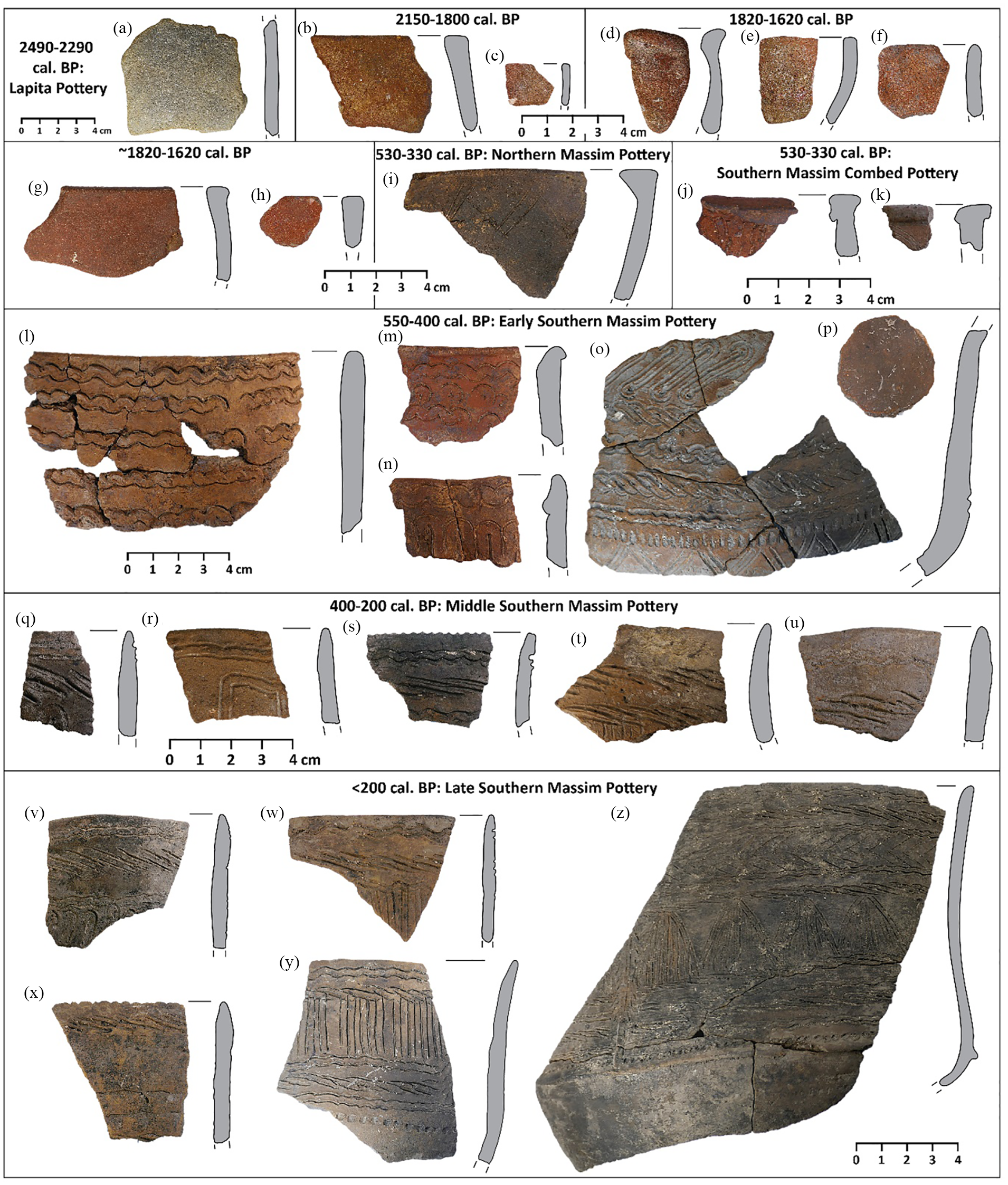
Selection of pottery spanning the last ~2400 years from Malakai. (a) Large body sherd, Unit C, Layer 10; (b) Unit B, Layer 8; (c) Unit C, Layer 9; (d–f) Unit C, Layer 7; (g) SP6, Layer 6–7 interface, equivalent to Unit C; (h) Unit B, intrusive, attributed to this age range based on similar fabric as sherd G; (i) SP7 adjacent to Unit B, Layer 6; (j) Unit B, Layer 5; (k) Unit C, Layer 5a; (l–n) Unit B, Layer 5; (o) Unit C, Layer 5a; (p) SP10, Layer 5a; (q–t) Unit C, Layer 5a; (u) Unit C, Layer 4; (v–y) Unit C, Layer 1a/b; and (z) Unit C, Layer 3.
All sherds from layers dating to 2490–1610 cal. BP in Units B and C (N = 24) were plain, so too were intrusive sherds deriving from these layers (N = 5) and sherds in corresponding early layers from spade pits (N = 6). A lack of decoration cannot be attributed to erosion as slipping was preserved on the surface of eight sherds (e.g. Figure 5d–e, g–h). Sherds of this age from the lowest layers on Wari Island (N = ⩽13), the only other Massim site of this age, were also plain. While a relatively small regional assemblage it appears pottery in the Massim was not decorated over this time, or at least decoration was very rare. Rim sherds (N = 7) demonstrate the presence of vessels similar to those from late Lapita and EPP assemblages in the Bismarck Archipelago and south coast of New Guinea (Table S7, available online). Bowls/pots with everted rims (Figure 5d and g) and direct rims (Figure 5e), and bowls with direct (Figure 5b, c and h) and outcurving (Figure 5f) rims were identified. See Figure S6 (available online) for reconstructed vessel forms.
Late pottery (⩽530 cal. BP)
The re-settlement of Nimowa by 530 cal. BP coincided with the earliest expression of Southern Massim Pottery (SMP) (Figure 5l–o). SMP was manufactured on several islands in the southern Massim region, and has been found on the surface and in excavation on islands from Tubetube to Rossel, spanning at least 400 km (Irwin et al., 2019; Shaw, 2016). It has otherwise only been found in trace quantities on northern Massim islands, and perhaps also on the mainland (Bickler, 1998; Irwin, 1985). SMP can be divided into early (~550–400 cal. BP), middle (~400–200 cal. BP) and late (~⩽200 cal. BP) phases, which traces a continuum of pottery development up until the modern day. The Layer 5, 3 and 1 habitation surfaces in Unit C reflect these phases of SMP development. In Unit B, only early SMP was identified. Previous petrographic and chemical analyses have shown that none of the SMP pottery was locally manufactured on Nimowa, and the sequence here indicates no break in pottery supply over this time (Shaw et al., 2016).
Trends in vessel form and decorative conventions occurred over the last 530 years reflect gradual changes in economic function and subsistence patterns (see also Shaw and Dickinson, 2017). From 530 to 400 cal. BP (early SMP), unrestricted carinated bowls predominated, with outcurving and direct rimmed pots present in smaller numbers (Figure 5l–o and Figure S6, available online). After 400 cal. BP (middle–late SMP), large unrestricted pots became more common (Figure 5q–z). SMP vessels generally ranged in diameter from 28 to 42 cm, which is consistent in size with modern southern Massim cooking pots (Table S7, available online). Two circular pot sherds (40 and 34 mm) from Layers 5a and 3 in Unit C, respectively, had likely been used as stoppers on water vessels (Figure 5p). As no SMP pottery has narrow orifices, they must have been stoppers on vessel made from another material, perhaps gourd. Red slipping and burnishing were present on early SMP vessels (e.g. Figure 5 m) and dropped almost entirely out of use within the last 400 years. As it takes longer to apply these finishes, it can be implied that this was to increase the relative value and presentation of the vessel. Although SMP was manufactured on several islands, the motifs used are remarkably similar indicating shared cultural conventions between southern Massim populations. Almost all vessels had decoration on their neck and upper body. Incision (comb and gash) was identified on >92% of decorated sherds in the form of geometric motifs. Impression and appliqué typically defined the upper and lower margins of the incised motif panels, accounting for its lower frequency in the assemblage (see also Shaw and Dickinson, 2017).
Trace quantities of Southern Massim Combed Pottery (SMCP, n = 4) were identified in layers with early SMP only (Figure 5j and k). SMCP has recently been dated to ~800–400 cal. BP on Panaeati Island, where it was likely also manufactured (Shaw, 2019). A single everted flat lipped rim sherd was also found in a late context from Unit B (Figure 5i), and is consistent in form and decoration with undated prehistoric bowl sherds (PR19-20) from the D’Entrecastreaux Islands (Lauer, 1970: Plate 61). A northern Massim origin for this sherd is indicated by the vessel shape and the presence of white mica in the clay which is unique to pottery from this area (Shaw et al., 2016) (Figure S6, available online). The limited presence of these two pottery styles indicates they were already declining in production and trade by the time Nimowa was re-settled, coinciding with the almost complete replacement by SMP.
Limited use of non-local resources
Obsidian
Low densities of obsidian imported to Nimowa Island over the last 2150–1940 years (n = 28, 45 g) suggests the population was on the periphery of networks with island communities closer to the New Guinea mainland where the nearest obsidian source is located (Fergusson Island, D’Entrecastreaux group, 300 km away) (Figure 6a). Obsidian was notably absent from Lapita contexts (2490–2290 cal. BP). At this stage, it is uncertain whether its absence is because of a shallow marine depositional context or because it was not transported to the island at this time. The mass of obsidian, extrapolated by volume of the associated layers, indicates that there were two major peaks in obsidian importation to Nimowa (Figure 6b, Appendix 3). It was first imported from 2150 to 1800 cal. BP with a relatively high density of 302 g/m3. Import decreased substantially (8 g/m3) from 1800 to 1610 cal. BP and ceased entirely from 1610 to 530 cal. BP. Obsidian import recommenced from 430 to 310 cal. BP (6.3 g/m3) and reduced to trace quantities within the last 310 years (0.4 g/m3).
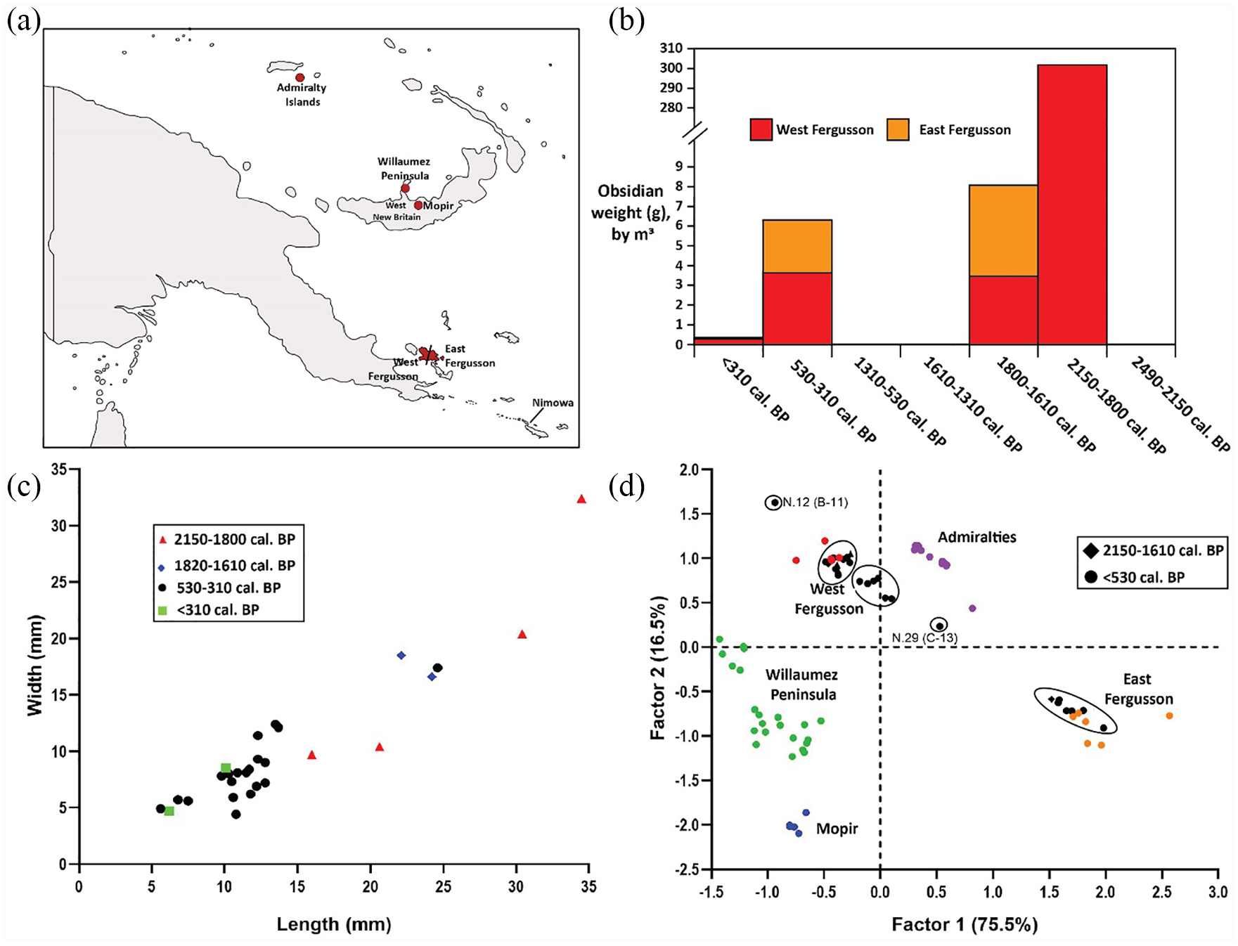
Sourcing and metric data of the Malakai obsidian. (a) Location of obsidian sources in New Guinea. (b) Obsidian quantity (g) based on volume of excavated layers and corresponding radiocarbon ages, extrapolated to 1 m3. (c) Biplot of the length and width (mm) of excavated obsidian by age. (d) Factor analysis against known sources in the New Guinea region, with west and east Fergusson sources exploited. Circles suggest six sub-sources were exploited.
The obsidian assemblage comprised flake pieces (n = 11), complete flakes (n = 8), angular fragments (n = 8) and a single multiplatform core (Figure S7a–f and Table S8, available online). The core (27.6 g) came from an early context (Layer 8, Unit B, 2150–1940 cal. BP) and had been exhaustively reduced using bipolar percussion flaking. Water rolling was identified on four of the six early context pieces, suggesting they had been deposited in the inter-tidal zone. The size of the obsidian pieces indicates an increase in the intensity of reduction over time, with a mean length of 25 mm in early contexts (n = 6) which decreased to 11 mm in late contexts (n = 22) (Figure 6c). The presence of cortex on a single early obsidian piece further suggests primary reduction of raw obsidian nodules largely took place prior to reaching Nimowa. However, the exclusive presence of angular fragments in late contexts infers some secondary reduction occurred on-site following re-settlement. Use wear was identified on seven pieces, of which four were also retouched, and at least one late piece had a deliberately prepared point (Figure S7d, available online).
Obsidian sourcing
Chemical sourcing of the obsidian using portable x-ray fluorescence spectrometry (pXRF) determined that all pieces came from Fergusson Island. Overall, 75% (n = 21) came from western Fergusson sub-sources (Fagululu and Kukuia Peninsula) and 25% (n = 7) from eastern sub-sources (Sanaroa Is., Numanuma and Mount Lamonai), including one piece dated to 1820–1610 cal. BP (Figure 6d, Tables S9–11). A comparison of the Malakai obsidian to geological samples suggests at least five different sub-sources were utilized, with the locations of some not yet identified. Substantive obsidian assemblages analysed from several other southern Massim islands as part of a larger project, to be presented in a forthcoming paper, further supports the sub-sources identified in the Malakai obsidian. Given the distance of Nimowa from Fergusson and the small size of the obsidian, it is probable that the inhabitants at these two locations were not in direct contact over the last 2150 years but received obsidian through down-the-line exchange. The D’Entrecastreaux pot sherd may also have been obtained through the same means as it likely came from the same island group as the obsidian. Furthermore, it had been hypothesized that the eastern Fergusson obsidian was only available in late prehistory, either because of its formation or accessibility (Bird et al., 1981). The presence of east Fergusson obsidian in a secure early context demonstrates that these sources were available. A late prehistoric increase in the presence of east Fergusson obsidian is consistent with islands near these sources becoming involved in a large-scale regional exchange network – Kula. On the other hand, the continued preference for west Fergusson obsidian indicates social relationships, logistics and obsidian quality influenced patterns of exploitation.
Lithics
Only two lithic artefacts were recovered from excavation, both of which were non-local to Nimowa and indicate inter-island interactions of at least 90 km occurred within the Louisiade Archipelago (Figure S8, available online). Locally available stone on Nimowa is heavily foliated, soft and not suitable for tool production (Figure S1e, available online). The first lithic artefact was a water-rounded and partially ground consolidated volcanic ash pebble containing gold-coloured mica, dated to 1820–1610 cal. BP (Unit C, Layer 7) (Figure S7 h, available online). Bedded ash deposits with these mica inclusions occur on the north coast of Misima Island (Kobel Volcanic formation), and local informants recognized the artefact as coming from Misima (de Keyser, 1961). The second was a red fine-grained siliceous siltstone point with use wear dated to 530–330 cal. BP (Unit B, Layer 5) (Figure S7 g, available online). Outcrops of red iron–stained siltstone are also known on the north coast of Misima (Gulewa Conglomerate formation) and on the western Calvados Islands (Panaroa Volcanic formation) (Smith and Pieters, 1969).
Adaptive use of local materials for tool production
Shell
In the absence of locally available high-quality lithic resources on Nimowa and across much of the Louisiade Archipelago, shell was the primary material used for tool production (Figure 7). A substantive suite of shell tools and ornaments (n = 64) was recovered (Table S12, available online), much larger than assemblages from other Massim sites, but are generally consistent with tools/ornaments found in Pacific island coastal sites since the Lapita period (Szabó, 2010). On-site manufacture is indicated by artefacts in different stages of reduction (see stages in Figure 7). At least 11 shellfish taxa were utilized, although 78% (n = 50) of artefacts were manufactured from only six (Tridacna, Anadara, Strombus, Pinctada, Cypraea and Trochus sp.). Net weights (n = 12), scrapers (n = 10) and armband blanks (n = 3) made from these taxa were found in both the early and late contexts.
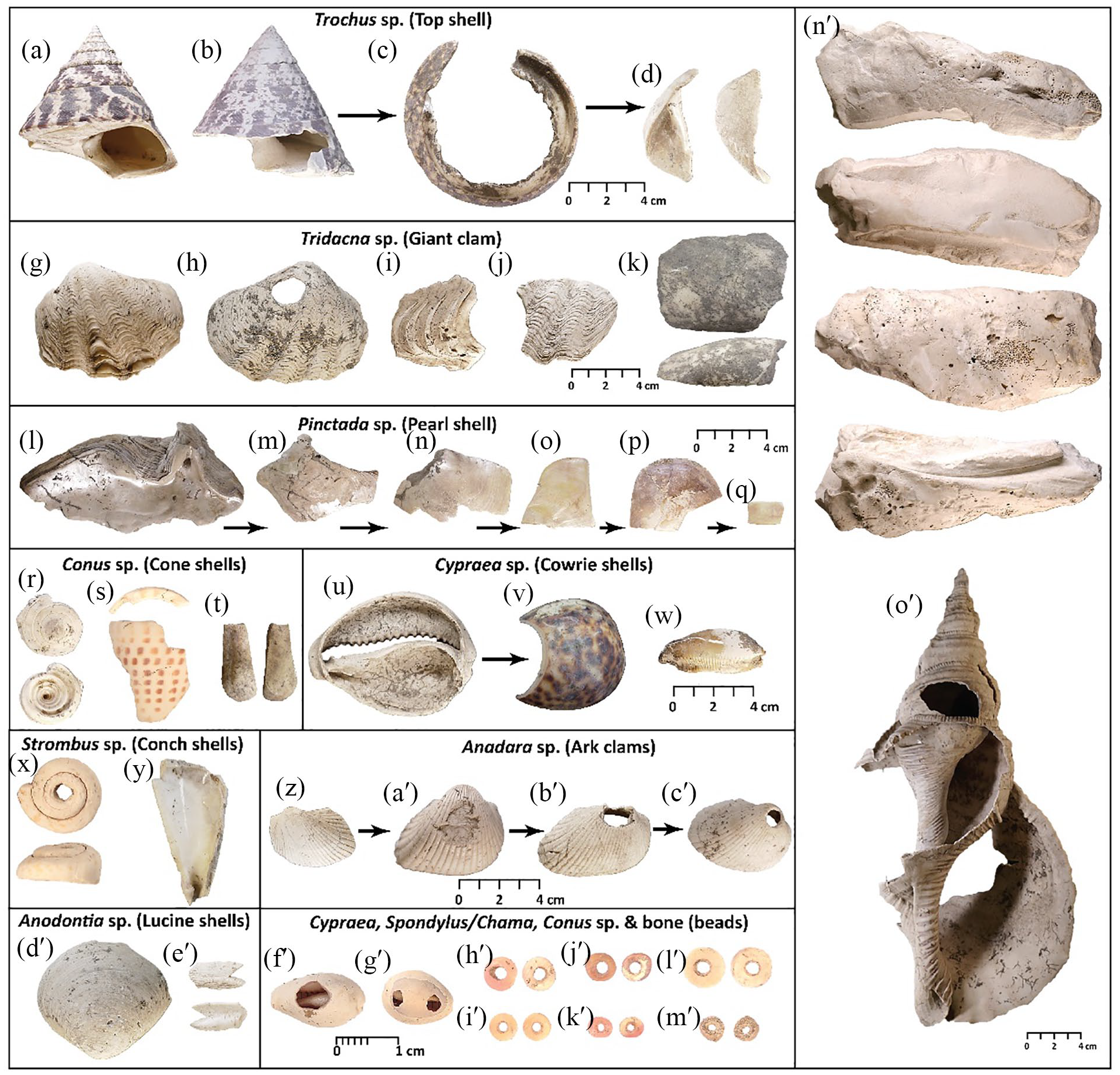
Shell technology from Malakai demonstrating reduction and tool use. (a–d) Top shell armband production and other tools. (g–k) Giant clam end scraper, net weight, peeler and adzes. (l–q) Pearl shell scraper and serrated scraper production, and small tab. (r–t) Cone shell bead, ring and scraper/adze. (u–w) Cowrie scrapers and awl. (x and y) Conch shell bead, and scraper preform. (z–c′) Ark clam side scraper and net weight production. (d′ and e′) Lucine shell scraper and bifurcated tool. (f′–m′) Cowrie and clam shell beads. (n′) Robust Tridacna gigas hinge adze preform from SP7 (adjacent to Unit B), Layer 8. (o′) Charonia tritonis trumpet from SP10 (adjacent to Unit C), Layer 3.
Shell adzes in the Massim have so far only been found at the Malakai site, which now includes a robust Tridacna gigas hinge adze blank (1.36 kg, 200 mm (L) × 85 mm (W) × 75 mm (T)) dating to 2150–1940 cal. BP, one of the largest known in Melanesia (Figure 7n′) (Kirch and Yen, 1982). Two ground Tridacna crocea dorsal adze preforms from late contexts were similar in size and form to those found in the Siassi Islands (Lilley, 1986), and defined as type 2 adzes using Kirch and Yen’s (1982) typology. A complete Charonia tritonis trumpet with a perforated blow hole in the spire was dated to ~300 BP and is one of the few near-complete archaeological examples in the Pacific region (Figure 7o’). Large modified Cypraea tigris bases and tops were found in late contexts only, and were likely used as scrapers/peelers, with a partial base used as an awl (Figure 7u–w). Beads made of Spondylus/Chama sp. (n = 6), Cypraea sp. (n = 3), Conus sp. (n = 1) and Strombus luhuanus (n = 1) were recovered from late contexts along with a small tubular bone bead, most of which came from layers dating to the last 300 years (Figure 7x, f′–m′). Spondylus sp. beads are still made on Nimowa for necklaces (Figure S1 h, available online). Ring production is also indicated by large Conus litteratus body fragments which have had the spires removed (Figure 7s).
Bone, coral and pumice
A dugong rib bone with a ground and polished bevelled end is unique in the Pacific region and reflects the adaptive use of bone for tool production (Figure S7i and Table S13, available online). The orientation of the bevel indicates the tool may have been used as an adze. However, dugong bone is very dense and would fracture easily against hard wood, so it was probably limited to cutting soft materials such as fibrous plants, or it served a different function. Ethnographic records in the Massim demonstrate dugong bone and ivory had been used for betel nut (Arecea catechu) pounders, lime spatula and basket weaving needles (Armstrong, 1928; Hamson and Aldridge, 2009; Pernetta and Hill, 1981). Very few dugong bone artefacts are known from prehistoric contexts in New Guinea (Allen, 2017; Vanderwal, 1973). An urchin spine with a worked distal end found in the same context may have been used as an awl or perhaps a betel pounder (Figure S7k, available online). A large piece of pumice had been used as an abrader, and a coral head as a pestle-like pounder (Figure S7j and l, available online). Pumice is often used for polishing bone and stone tools, and coral pounders may be used for processing food, cracking nuts or perhaps for breaking shell during the production of bead manufacture (Egloff, 1979).
Subsistence refuse reflects reliance on lagoon and adaptations to changing island ecosystem
Fauna
The inhabitants at Malakai over the last 2490–2290 years predominantly obtained their protein locally from the surrounding lagoon, with smaller contributions from terrestrial and domestic fauna. A total of 2681 vertebrate and crustacean remains weighing 547 g were recovered from Units B and C, of which the majority (98% by NISP and 84% by weight) came from Unit C and mostly from layers spanning the last 530 years (Tables S14–17). Only four fish bones came from an early context (2150–1940 cal. BP, Unit B). Between both units, marine fauna made up 93% of the assemblage by NISP and 64% by weight. Of the identified marine taxa (NISP = 355), turtle comprised 24%, parrotfish 22%, crayfish 15% and triggerfish 13%, with 18 taxa making up the remaining 26%, including dolphin, shark, stingray and moray eel. By weight, turtle comprised 38% of identified marine taxa due to its denser and larger bones. All marine species could have been harvested within the lagoon. Terrestrial fauna, all from late prehistoric layers, mostly comprised pig (Sus scrofa), dog (Canis familiaris) and possum (Phalanger sp.), with small quantities of rat (Muridae), monitor lizard (Varanidae), fruit bat (Pteropodidae) and human bone. The human bone may have come from a disturbed burial context rather than deposited as food refuse, as a burial dating to 470–130 cal. BP was found in nearby Unit A (see Shaw and Dickinson, 2017).
Shellfish
The excavated shell refuse indicates patterns of marine exploitation changed as the beachfront expanded and shellfish habitats near the site were modified. A minimum of 2700 individuals weighing 31 kg were recovered, with 93% by MNI derived from Unit C (Tables S18 and S19, available online). The uneven density of fauna and shell between these units reflects preferential human habitation of the palaeo-beach ridge. In Unit C, peak densities of rock-dwelling species (mainly Nerite and Turbo sp.) coincided with defined habitation surfaces (Layers 5a, 3 and 1a/b) (Figure S9, available online). Mangrove-dwelling species (mainly Gafrarium, Pythia and Potamididae sp.) also followed this pattern but decreased in abundance within each layer, whereas sand-dwelling species, primarily Mactra sp., increased markedly within the last ~300 years (Layers 1–3) (Figure 8). The inverse relationship between sand and mangrove shell within the last 530 years reflects a rapidly prograding beach and retreating coastal mangrove. Very little mangrove now remains along Malakai beach, but a thicker patch in the southern end of the same bay gives an indication of how widespread it once was (see Figure 2a and Figure S1d, available online). Reef-dwelling species were present in low numbers throughout Unit C, suggesting that this habitat was not heavily exploited at any time. This pattern is in contrast to Unit B where almost all of the shell (119 MNI, 7.5 kg) came from the midden in Layer 8, which comprised mostly Giant clam (Tridacna/Hippo sp.) and Turban (Turbo sp.) shell from the reef and rocky shore environmental contexts, respectively. The relatively high concentration of reef-dwelling shellfish here compared with in Unit C likely reflects targeted harvesting of these species over a relatively short space of time.
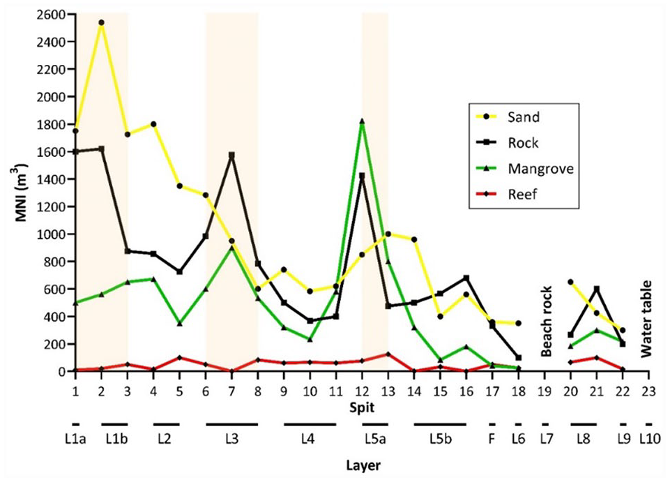
Concentration of shellfish by habitat in Unit C, standardized to MNI/m3. The three defined habitation surfaces are highlighted, which correlate with peaks in shellfish harvesting.
Discussion
Archaeological investigations on Nimowa have produced a detailed cultural sequence which has shed light on the adaptive responses of humans to changing island ecosystems in the Massim region of eastern New Guinea over the last 2490–2290 years. Nimowa was inhabited by a late Lapita population during the initial stages of beach formation. Earlier coastal settlement of Nimowa was not possible as the island formed part of the hilly interior of the Greater Calvados Island during the late Pleistocene. Post-glacial sea-level rise in the early Holocene (11,700–8200 BP) subsequently flooded large tracts of the former coastline, and mid-Holocene sea levels exceeded modern levels by 1–3 m. Significantly, Lapita settlement is known elsewhere in the Massim and on the south coast of New Guinea from 2950 to 2700 cal. BP, indicating that Nimowa was occupied as soon as the coastline was habitable (McNiven et al., 2011; Negishi and Ono, 2009; Shaw, 2019). The low densities of material culture suggest small-scale and perhaps intermittent settlement during the late Lapita period, although deposition in a shallow marine environment may also have influenced the range and density of material present.
The development of the beach deposit at Malakai coincided with significant periods of global climatic change, and the material record reflects behavioural adaptations to a small and relatively isolated island ecosystem. Throughout the cultural sequence, locally abundant shell was the primary material used to produce tools in the absence of high-quality lithic resources on the island. Very few resources were imported from other islands, with the low density of obsidian indicating that contact with communities outside of the Lousiaide Archipelago was not regular at any time, even following the emergence of the regionally important Kula exchange network. Such a pattern reflects those observed in coastal sequences of southern New Guinea where obsidian trade was ongoing but intermittent since Lapita settlement (Irwin, 1985; Mialanes et al., 2016; Summerhayes and Allen, 2007). Marine foods from the surrounding lagoon also comprised most of the diet, further indicating a heavy reliance on local resources. The abandonment of Nimowa and a lack of sediment accumulation between 1290 and 530 cal. BP coincided with the MCA, during which time there were significant fluctuations in annual rainfall resulting in shortfalls in available freshwater. Small low-lying islands such as Nimowa lack permanent flowing water sources and the risk of drought is high, with people relying on rainwater for storage and to recharge underground aquifers.
Population movements and risk-reduction strategies in late prehistory
The emergence of large-scale exchange networks over the last 550–500 years in New Guinea has long been associated with risk-reduction strategies (Macintyre and Allen, 1990; Oram, 1982). Our findings in the Massim, when integrated with regional archaeological records, strengthen the correlation between these risk-reduction strategies and periods of climatic stress (Allen, 2010). Inter-island connections in the Massim were developed during a period of relatively unstable seasonal climatic patterns immediately prior to the LIA, during which time specialist producers and effective ‘middle-men’ traders emerged on small islands. Coral records in the Massim demonstrate ENSO-forced drought conditions had significantly reduced from 550 to 300 BP, coinciding with the re-settlement of Nimowa and the earliest expression of local pottery traditions (Hereid et al., 2013; Irwin et al., 2019). We suggest that social changes which enabled the regional expansion of exchange networks occurred during the time when Nimowa was abandoned, from 1290 to 530 cal. BP. On larger islands in the northern Massim over this time, a shift in burial practices, use of megalithic structures and strengthening inter-island connections indicate adaptive changes were made to existing systems of social organization (Bickler, 2006; Egloff, 1978).
It is hypothesized that during periods of climatic stress, populations migrated to larger islands (e.g. Sudest, Rossel or Misima) or to the New Guinea mainland, both of which have permanent flowing rivers and up to twice the annual rainfall because of their higher topography. On the south coast of New Guinea, disruptions in settlement and pottery production from ~1200 to 800 BP have been correlated with climatic stress on crop productivity, resulting in a strategic re-organization of people to areas where access to traded foods could be secured (Allen, 2010). The closer similarities of Massim and south coast pottery traditions after 800 BP and certainly by 500 BP may be a result of closer trade interaction between populations in these areas (see Bulmer, 1971).
An increased predictability of seasonal rainfall during the LIA eased constraints on population movements and the rapid growth of beachfronts within the last 500 years made small islands in New Guinea increasingly strategic locations for settlement and as regional trade hubs. The increased exploitation of East Fergusson obsidian in later prehistory, despite it being available earlier, may also be due to small islands near these sub-sources being more intensively occupied during the LIA, and with the emergence of the Kula exchange network. With population densities increasing and competition for access to high-value resources intensifying in coastal and island regions, warfare also became endemic and is clearly reflected in the archaeological record (Irwin et al., 2019).
Conclusion
Patterns of island settlement coincide with changing climatic regimes in the Massim, and our results contribute to models of human adaptive behaviour in response to periods of climatic stress. The combined sediment and material culture analyses on Nimowa Island demonstrate that people on small islands were sensitive to changes in sea level, rainfall and cyclone frequency. The Massim islands were likely colonized in the late Pleistocene, but many islands had unstable coastlines until the late Holocene. During protracted periods of drier conditions, people abandoned the island and likely withdrew to larger islands with a more stable resource base. An influx of people into the Massim islands within the last 500 years influenced inter-island social organization, with similar patterns identified on the New Guinea mainland.
Supplemental Material
Malakai_manuscript_-_Supplementary_Figures,_tables_and_text – Supplemental material for 2500-year cultural sequence in the Massim region of eastern Papua New Guinea reflects adaptive strategies to small islands and changing climate regimes since Lapita settlement
Supplemental material, Malakai_manuscript_-_Supplementary_Figures,_tables_and_text for 2500-year cultural sequence in the Massim region of eastern Papua New Guinea reflects adaptive strategies to small islands and changing climate regimes since Lapita settlement by Ben Shaw, Simon Coxe, Vincent Kewibu, Jemina Haro, Emily Hull and Stuart Hawkins in The Holocene
Footnotes
Acknowledgements
The authors thank the community on Nimowa Island for permission to undertake the research – in particular, to John Bian and family at Malakai village, to Noah Mwegumwegu at the mission station, and Donald, their esteemed boat captain, who got them safely around the Lousiaide Archipelago. A heartfelt thanks to Anthony Young, the residing priest on Nimowa, whose help was instrumental in setting up the research on the island. They also thank the National Museum and Art Gallery of Papua New Guinea, namely Alois Kuaso, the National Research Institute, namely Georgia Kaipu, and the Provincial Government of Milne Bay for supporting the research programme. The authors acknowledge Sarah Kelloway and Irene Wainwright of the XRF Facility within the Mark Wainwright Analytical Centre at the University of New South Wales for pXRF support. Thank you to Len Martin for assistance with the particle size and loss-on-ignition analyses and to Martin Van Kranendonk for confirming the lithic identifications. Cathryn Barr from Extent Heritage provided advice on the relative dating of the wine bottle fragment. Thank you to Glenn Summerhayes for reading a draft of this manuscript.
Author contributions
BS formulated and obtained funding for the project. BS, SC, VK and JH developed the excavation strategy and conducted the excavations. EH conducted the pXRF analysis of the obsidian. EH, SC and BS analysed the obsidian artefacts. BS conducted the particle size and loss-on-ignition analyses of the sediments; the pottery, lithic, shell, bone, coral and pumice artefact analyses; and the shellfish subsistence analysis. SH analysed the animal bone assemblage. BS drafted the manuscript, with all co-authors contributing to the final version.
Availability of data and materials
All data are available in the main text and in the supplemental materials.
Declaration of conflicting interests
The author(s) declared no potential conflicts of interest with respect to the research, authorship and/or publication of this article.
Funding
The author(s) disclosed receipt of the following financial support for the research, authorship and/or publication of this article: The project was funded by an Australian Research Council Discovery Early Career Award (DECRA, DE170100291) awarded to Shaw for the period 2017–2019 and by the University of New South Wales Faculty of Science.

Supplemental material
Supplemental material for this article is available online.
References
Supplementary Material
Please find the following supplemental material available below.
For Open Access articles published under a Creative Commons License, all supplemental material carries the same license as the article it is associated with.
For non-Open Access articles published, all supplemental material carries a non-exclusive license, and permission requests for re-use of supplemental material or any part of supplemental material shall be sent directly to the copyright owner as specified in the copyright notice associated with the article.
