
Abstract
Macroscopic charcoal records from wetland sediment cores are used to reconstruct long-term records of fire frequency. A central premise for the use of this tool is that macroscopic charcoal (>125 μm) represents local fires involving local vegetation. Several records reveal that there may often be exceptions to these guidelines. Previous studies have shown that particles larger than 1 cm long can travel at least 20 km from the location of a fire. We present observations of unprecedented long-distance transport of large (⩽5 cm long) charcoal particles at least 50 km from a fire west of Sydney, Australia. Factors that contribute to long-distance transport of large charcoal particles are fire intensity, upper level wind speed and landscape topography. The fires west of Sydney were large and intense, upper level (~10 km) winds exceeded 90 km h-1, and the topography east of the fire was flat or undulating. Smoke plumes from intense fires like this can reach an altitude of at least 15 km. Charcoal morphology also contributed to long-distance transport in this case. Eucalyptus trees can produce large quantities of aerodynamically efficient particles; from paper thin, smooth, decorticating bark and large sclerophyllous leaves. The presence of large macroscopic charcoal particles in wetland sediments does not automatically indicate local fires and could result from distant, large, intense fires. Large, intense fires can occur in Australia, the grasslands of Kazakhstan, Namibia, the Sahel and Patagonia. High intensity fires also occur in the forested areas of the western United States and Boreal North America. Fires in these regions could result in long-distance transport of large macroscopic charcoal particles under the right circumstances. Local charcoal flux studies are therefore critical for the interpretation of macroscopic charcoal records. We cannot rely on information from areas with different fire regimes, fire intensities or vegetation types.
Introduction
Macroscopic charcoal particles preserved in wetland sediments can be used as a proxy for fire location, type of vegetation burnt, fire frequency and intensity (Whitlock and Anderson, 2003). A central premise for the successful use of this tool is that macroscopic charcoal (>125 μm) represents local fires involving local vegetation (Whitlock and Anderson, 2003). Attributing fires to source areas is critical for inferring climate/fire relationships and to determine the effects of catchment fire on wetland ecosystems. Whitlock and Anderson (2003) state that the 126–1000 µm fraction typically travels less than 7 km from the fire, and the >1 mm fraction only travels less than 100 m from the fire. There are, however, several published studies that show that macroscopic charcoal fractions can travel much further than this in the right circumstances. The longest previously recorded transport distance was 20 km for ~1 cm long macroscopic charcoal particles from a fire in Montana, USA (Pisaric, 2002). Oris et al. (2014) proposed a transport limit of macroscopic charcoal (>150 μm) of 32 km from fires in north eastern Canada. This indicates that we must be mindful that large macroscopic charcoal particles can travel great distances when analysing down-core macroscopic charcoal data.
Low rainfall and high temperatures in the Southern Hemisphere spring (September–November) 2019 led to large intense forest fires along a 1500 km stretch of the coastline in Eastern Australia. Large fires west of Sydney (Figure 1) started in dry sclerophyll (predominantly Eucalyptus species) forest on the 27th November 2019. The closest climate station to the fire front is Campden (Figure 1). The September–November rainfall total was 103 mm at this site, which is well below the average of 170 mm (Australian Bureau of Meteorology, 2019). The average 3 pm temperature in the month leading up to the Sydney fires was 28.5°C, which is ~4°C higher than the average for this area at this time of the year. At the time of writing (11 December 2019) the fires have burnt approximately 110,000 ha (1100 km2) and are still considered to be out of control.
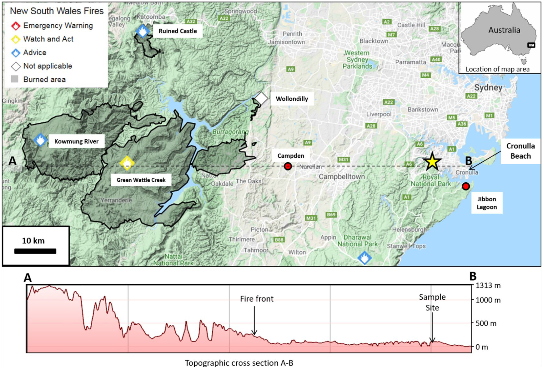
Location of the study site on the east coast of Australia. The map is extracted from the New South Wales Fire database (NSW Rural Fire Service, 2019) and shows the status of fires and area burnt as of the 7 December 2019. The yellow star shows the location of the macroscopic charcoal flux study. Abundant macroscopic charcoal particles were also observed on Cronulla Beach. The location of a down-core macroscopic charcoal study from Jibbon Lagoon (Mooney et al., 2001) is also shown. A topographic cross section A–B shows the topography between the fire source area and the sample site.
In this paper, we present some observations of macroscopic charcoal transport during large, intense forest fires, west of Sydney, Australia (Figure 1). We observed very large (up to 5 cm long) charcoal particles transported at least 50 km from the fire front. This is an unprecedented record of long-distance macroscopic charcoal transport, so we think it is important to discuss the implications of this phenomenon for fire history reconstruction.
Methods
Fire location information and synoptic weather patterns
The location of all fires in the vicinity of Sydney was extracted from the New South Wales Rural Fire Service database (NSW Rural Fire Service, 2019). This website provides up-to-date information on the status of each fire and the total area burnt. Synoptic weather maps (mean sea level maps) were extracted from the Australian Bureau of Meteorology (BOM) website (Australian Bureau of Meteorology, 2019). A map was extracted from near the beginning of the sampling period (1 December 2019) and towards the end of the sampling period (6 December 2019). Information on wind speed and direction was also extracted from the website: https://earth.nullschool.net. This web-based platform allows users to visualise global weather patterns and extract data weather phenomena. Data are archived so it is possible to access data in real-time or for previous conditions. This supplemented the information provided by the BOM weather maps because we could also examine changes in wind speed and direction with altitude. The position of the smoke plumes from local fires was obtained from the website: https://zoom.earth, which provides daily satellite images.
Charcoal sampling and analysis
A macroscopic charcoal sample was collected from a 9.2 m2 open balcony on the exterior of an apartment building in Sutherland, Sydney, Australia on Friday, 6 December 2019. The sampling was opportunistic as the authors observed unusually large (≤5 cm long) charcoal fragments falling out on the tiled surface of the balcony when the only observed fires were >40 km away. The balcony is on the fourth floor of the apartment complex and there are no other tall buildings immediately to the west. There is a park and single story residential properties to the west in front of a large river gorge.
The balcony was completely swept clean on Saturday, 30 November 2019. Following sweeping, large charcoal particles fell after a large (885 km2 at the time of sample collection) forest fire to the west, when the prevailing wind shifted from a north-westerly to a westerly wind. Charcoal particles were collected by gently sweeping them with a soft brush into a plastic container. Gentle handling of the macroscopic charcoal was undertaken to minimise particle breakage.
The macroscopic charcoal was spread out on an A4 sheet of paper to maximise particle separation and reduce overlap. The sample was then photographed to enable a total particle area calculation using the image analysis software ImageJ (Schneider et al., 2012). After photographing, the charcoal was then sieved through a series of nested sieves. The aperture sizes for the sieves were 90 μm, 125 μm, 250 μm, 1 mm, 2 mm and 4 mm. Aperture size selection was based on macroscopic size classifications most frequently mentioned in the literature (Oris et al., 2014; Pisaric, 2002; Tinner et al., 2006; Whitlock and Millspaugh, 1996). Macroscopic charcoal is generally defined as charcoal particles > 125 μm, but in Australia, samples are often sieved using a 250 μm sieve (Black et al., 2006, 2007, 2008; Mooney et al., 2001). We suspect this is due to the often very high charcoal flux produced by Australian fires.
Photographs were taken to enable calculation of total area of the charcoal particles for each of the separate size fractions using ImageJ. Particles were also counted for each fraction manually with the aid of a binocular microscope at 40× magnification. Image analysis in ImageJ involved converting each photograph into a binary image using a threshold adjustment to isolate charcoal particles. Threshold adjustment sets the cut-off between charcoal, non-charred material and the background. The particles analysis function was then used to calculate the particle area for each fraction in mm2. Macroscopic charcoal flux was calculated based on the charcoal count and area, combined with the calculated area of the balcony.
Results and discussion
Fire location information and synoptic weather patterns
During the sampling period five fires were active within the vicinity of Sydney (Figure 1). The synoptic weather maps from the BOM, plus data on wind speed and direction from the website: https://earth.nullschool.net (Figure 2), indicated a sustained westerly wind direction during the sampling period. The obvious source for the sampled macroscopic charcoal is the four fires to the west of Sydney; Green Wattle Creek, Kowmung River, Ruined Castle and Wollondilly (Figure 1). The Green Wattle Creek and Kowmung River fires were the largest with a combined area burnt of 885 km2 at the end of the sampling period. These fires are located in what is predominantly dry sclerophyll forest, and the forest canopy is dominated by seven species of Eucalyptus trees (Ryan et al., 1996).
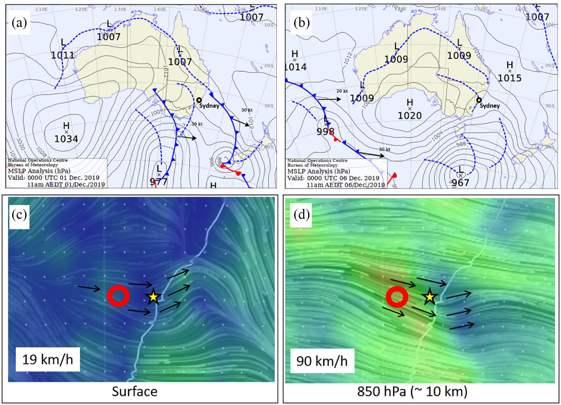
Synoptic weather pattern during the macroscopic charcoal sampling period. (a) and (b) are mean sea-level pressure maps of the Australian region (Australian Bureau of Meteorology, 2019). These show the movement of a high pressure cell (anticyclone) over southern Australia. This is the cause of the predominantly westerly airflow from the fire over Sydney. (c) and (d) show wind direction vectors (black arrows) and speeds at two different altitudes on 1 December 2019 (https://earth.nullschool.net). The red circle is the location of the fires and the yellow star is the location of the macroscopic charcoal study. Wind speeds at ~10 km are high enough for long-distance transport of large (>1 cm) macroscopic charcoal particles.
Satellite images confirmed that these two large fires were the most likely source of macroscopic charcoal to the sample site. Smoke plumes can clearly be seen passing over Sydney (Figure 3). The total distance from the sample site to the closest large fire (Green Wattle Creek) is 46 km. There were smaller spot fires ahead of the main fire front that could also contribute charcoal. The spot fires were ~42 km from the sample site.
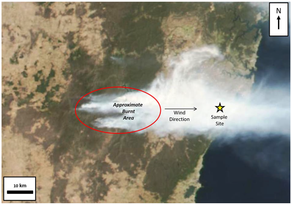
True colour satellite image of the smoke plume from the fires west of Sydney taken on 3rd December 2019 (https://zoom.earth). This highlights the easterly flow of the smoke plume over the sampling area (yellow star). The approximate area burnt by the Green Wattle Creek and Kowmung River fires (the largest fires) is circled.
Macroscopic charcoal composition and transport
A photograph of the macroscopic charcoal sample is provided in Figure 4. The largest particles were 2–5 cm long and comprised charred leaf fragments and charred wood. The largest leaf is clearly from a sclerophyllous tree such as a Eucalyptus spp. The minimum distance of transport for these large particles is 42 km, since this was the distance from our sample site to the smaller fires ahead of the main front. We also observed many charred sclerophyllous leaves and bark fragments (Figure 4) on the cliffs above Cronulla Beach (Figure 1). These were observed well above the high tide mark, behind the dunes and on cliff tops along a 5 km section of the Cronulla coast. We are certain that these particles also result from the major bush fires to the west during the sampling period since they were absent the week before. This adds another 9 km to bring the minimum transport distance for the large (⩽5 cm long) macroscopic charcoal particles to ~50 km.
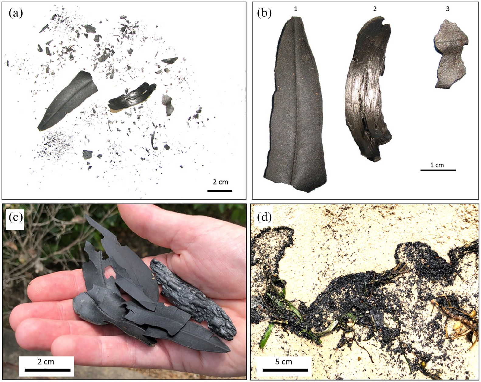
Macroscopic charcoal deposits collected and observed in Sydney. (a) Depicts the entire macroscopic charcoal sample collected from the balcony on 6 December 2019. (b) Depicts selected larger particles: (1) leaf from the sclerophyllous tree, possibly Eucalyptus; (2) woody fragment, possibly bark; (3) leaf fragment from an unidentified tree species. (c) Charred leaves and bark collected from the cliff tops at Cronulla, Sydney (Figure 1). These pieces were collected from within a 10 m area on open ground beside a walking track. (d) Concentrated deposits of macroscopic charcoal particles at the high tide mark on the beach at Cronulla, Sydney (Figure 1).
This phenomenon represents an unprecedented transport distance for large macroscopic charcoal particles based on existing literature. The longest previously documented transport distance was 20 km for ~1 cm long macroscopic charcoal particles from a fire in Montana, US (Pisaric, 2002). We observed much larger particles such as charred leaves and wood fragments up to 5 cm long (Figure 4) transported at least 50 km from the source fire. Oris et al. (2014) proposed a transport limit of macroscopic charcoal (>150 μm) of 32 km from the source fire since this was the furthest distance that they observed macroscopic charcoal from fires in north eastern Canada. Clearly, in the right circumstances, the transport limit for this fraction could be much further than the 50 km minimum distance we observed for 5 cm long charred leaf fragments.
Discussions about the environmental controls on macroscopic charcoal transport distance draw on observations of macroscopic charcoal deposits (Oris et al., 2014; Pisaric, 2002; Tinner et al., 2006; Whitlock and Millspaugh, 1996) and theoretical modelling (Peters and Higuera, 2007). Together, this information indicates that maximum macroscopic charcoal transport distance is a product of fire intensity, topography and wind velocity. Peters and Higuera (2007) demonstrated using modelling that macroscopic charcoal transport distance is a function of injection height or plume height. This represents the height particles can be lifted above a fire. Injection and plume height is a function of fire intensity, which is a measure of the amount of energy released by a fire. More intense fires provide more lift for large particles, thereby increasing the injection height. Particles that are lifted to higher altitudes are transported further.
A global review of fire intensities by Laurent et al. (2019) based on remote sensing data indicated that the largest and most intense fires occur in Australia, the grasslands of Kazakhstan, Namibia, the Sahel and Patagonia. High intensity fires also occur in the forested areas of the western United States and Boreal North America. Fires in these regions should result in high injection and plume heights which would result in long-distance transport of large macroscopic charcoal particles under the right circumstances. Since bush fires are intense in Australia, this could partially explain the long transport distance observed in our study.
Within regions capable of producing similar fire intensities, topography plays an important role in controlling macroscopic charcoal transport distance. Oris et al. (2014) argued that macroscopic charcoal transport is more limited in landscapes with higher topographic heterogeneity. More topographically heterogeneous landscapes would contain more barriers (such as mountains) that could impede airflow. This argument is supported by macroscopic charcoal studies from Canada and the western United States, which are areas that can both produce intense fires. Macroscopic charcoal was transported shorter distances from a fire in Yellowstone National Park (Whitlock and Millspaugh, 1996) than fires studied in north eastern Canada (Oris et al., 2014). The Yellowstone region is more topographically heterogeneous which would impede long-distance transport of macroscopic charcoal particles. The Sydney fires that we studied occur on the edge of mountainous terrain, with relatively flat topography to the east (Figure 1). This would favour the long-distance transport of macroscopic charcoal particles by the westerly winds that were observed during the sampling period.
We propose that the charcoal morphology produced by fires in certain vegetation types may also promote long-distance transport of large macroscopic charcoal particles. Large thin particles with a large surface area to volume ratio are more likely to be transported long distances due to their ability to be caught up and transported by convection. We noted that the large charcoal particles collected on the balcony site and observed at Cronulla (Figure 1) were thin particles, derived from charred sclerophyll leaves and bark (Figure 4). The large, thin sclerophyll leaves may be more prone to long-distance transport than conifer needles. Many sclerophyll species in Australia produce copious quantities of paper thin bark that is shed in large quantities. This would produce another source of large, thin particles. Cruz et al. (2012) also noted that Eucalyptus species with smooth decorticating bark provide large quantities of aerodynamically efficient firebrand material that can be transported over considerable distances. Long range spotting of approximately 30 km has been observed several times in Eucalyptus forests in Australia (Hodgson, 1967; McArthur, 1967). Such long transport distances are possible when upper level wind speeds are in the vicinity of 90–100 km h-1 (Luke and McArthur, 1978). Estimates for upper level wind speeds above the fire location were about 90 km h-1 at an altitude of approximately 10 km (Figure 2). Observations from similar forest fires in Australia have estimated a conservative maximum cloud/plume height of 15 km (Fromm et al., 2006).
Implications for fire history reconstruction
A major premise of charcoal-based fire reconstruction is that large macroscopic charcoal particles are produced from fires close to the core site. Whitlock and Anderson (2003) state that the 126–1000 µm fraction typically travels less than 7 km from the fire, and the >1 mm fraction only travels less than 100 m from the fire. Clearly, under the right circumstances, macroscopic charcoal can travel much further than this. This could lead to false positive identification of fires close to the study site. More data are required in the Australian context to check how this might affect down-core fire history reconstructions. We could not find any published macroscopic charcoal flux data from air fall charcoal traps in Australia. We observed a macroscopic charcoal (>125 μm) flux of 0.03 mm2/cm2 for the 6-day sampling period at a distance of at least 42 km from the fire. This would only represent a fraction of the total annual flux from this fire since fires like this in Australia can burn for weeks or even months (Victorian Bushfires Royal Commission, 2009). It seems quite plausible that the charcoal flux would exceed charcoal fluxes of between 0.098 and 0.144 mm2/cm2 observed ⩽5 km from large fires in the Swiss Alps (Tinner et al., 2006).
We can get an idea of how long-distance transport might affect Australian macroscopic charcoal records by examining down-core macroscopic charcoal flux in this area. Mooney et al. (2001) published a macroscopic charcoal record from Jibbon Lagoon, south of Cronulla (Figure 1). Flux is represented as counts/cm2/yr for this site, with the 125–250 μm fraction peaking at 1.2 counts/cm2/yr and the >250 μm peaking at 0.4 counts/cm2/yr. Over the 6-day sampling period, we observed a flux for the 125–250 μm of 0.006 counts/cm2 and 0.007 counts/cm2 for the >250 μm fraction. This may seem insignificant in comparison, but the down-core charcoal flux is annual flux compared to our flux spanning 6 days. Wetland macroscopic charcoal is also focussed from the catchment through overland flow and is not just air fall charcoal. If we multiply our flux to allow for a 30-day fire, which is quite reasonable for Australia (Victorian Bushfires Royal Commission, 2009), and include a modest focussing effect, it is possible to produce a flux similar to the >250 μm flux at Jibbon Lagoon. If we assume a catchment that is five times the area of the wetland, the maximum >250 μm flux achievable over 30 days would be 0.18 counts/cm2. Focussing effects could be considerably more for small wetlands with large catchments, especially coastal or estuarine sites. We observed large concentrations of macroscopic charcoal washing up on Cronulla beach (Figure 4). This charcoal is likely derived from direct fallout into ocean, and charcoal transported by rivers flowing from inland to the coast.
We should also remember that the particle and area flux we report here is 50 km from the fire front, and the effect is likely to be more significantly closer to the fire. Re-working and transport of the large flat particles from the catchment into a wetland may also increase the particle input and therefore flux.
It is therefore critical for down-core macroscopic charcoal records that we are mindful of the possible long-distance transport of large macroscopic charcoal particles in certain situations. More data are required on modern macroscopic charcoal fluxes to see how long-distance transport might affect peak detection in down-core records. It seems highly likely that long-distance transport could result in false positive detection of local fire events and focussing processes in wetland catchments could exacerbate this effect. Local charcoal flux studies are therefore critical for the interpretation of macroscopic charcoal records. We cannot rely on information from areas with different fire regimes, fire intensities or vegetation types.
Footnotes
Acknowledgements
The authors thank the editors and anonymous reviewers for their helpful comments on this manuscript. They would also like to acknowledge the people who lost their lives and property during the 2019–2020 Australian bush fires and the brave fire fighters of Australia who battle the blazes at the front line.
Funding
There were no external sources of funding for this research. Research was performed while CW was employed as a Postdoctoral Fellow at the University of Wollongong and HAH was a Research Assistant at the University of New South Wales.