
Abstract
Archeological investigations of the Mississippi Delta (U.S.) are reaching the century mark and provide information relevant to Holocene settlement patterns and present-day issues of human adaptation to coastal change. This review synthesizes the history of archeological research over the last ~100 years in the Mississippi Delta, an area that is deteriorating at a historically unprecedented rate. Early 20th century investigations provided sketches of pre-contact Indigenous culture, and extensive yet destructive Great Depression-era federal projects created the foundations of Mississippi Delta archeology. We highlight the abundant and underutilized data generated by regulatory cultural resource surveys over the past 50 years and, most recently, salvage efforts for a vanishing coast. From this centennial perspective, we advise on future research directions and demonstrate how coupling archeology with emergent theory on human-natural systems, including ecosystem services, benefits land-management practices here and in other landscapes undergoing rapid 21st century environmental change.
Keywords
Introduction
Deltas serve as the hubs of humanity’s ancient highways, that is, river channel networks. These landscapes provide nearly unmatched habitat, resources, and natural transportation for human settlement, and as such are among the most important locations for understanding humanity’s relationship with nature. In other words, the study of a delta’s cultural record is a prime example of human-landscape dynamics. As deltas worldwide experience unprecedented present-day change (e.g. Giosan et al., 2014; Kulp and Strauss, 2019; Small and Nicholls, 2003), coastal societies must adapt in-kind. The archeological record offers the only millennial-timescale record of human adaptation to environmental change in many locations including North America and is particularly useful for studying how ancient peoples responded to fluctuating landscapes. Archeological studies therefore must play a key role in how present-day societies understand and adapt to rapidly diminishing coasts.
In this article, we synthesize the archeological research conducted over the past century in the Mississippi Delta of southeastern Louisiana, U.S. (Figure 1), and use these findings to make recommendations for future research approaches and initiatives in the context of coupled natural-cultural systems and ecosystem services. This means considering the multiple functions and benefits of landscapes integrated across ecology, geomorphology, and social science disciplines. The centennial benchmark is used for our review because most of the first scientific excavations in the lower delta began during the early 20th century, so we now have a ~100-year record from which to synthesize findings for the first time.
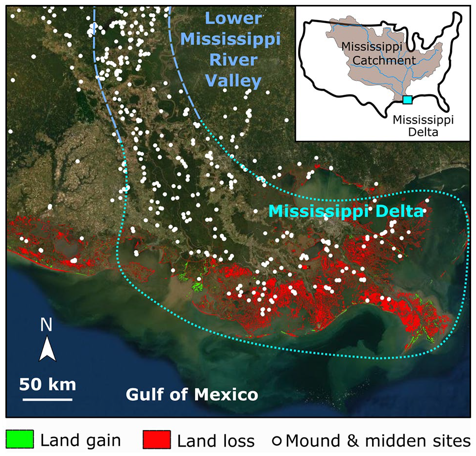
Map of the Mississippi Delta. Archeological mound and midden sites are indicated by white filled circles, and areas of land loss (red) and gain (green) from Couvillion et al. (2017) are shown.
Unlike some large deltas of the world, the Mississippi Delta contains a short written (historical) record that spans only a few hundred years and is largely incomplete prior to about 1700 CE (0.3 ka). This means regional histories of human-landscape interactions must be reconstructed from the material record obtained from archeological sites (e.g. Kidder and Sherwood, 2017) or the oral traditions of post-contact tribes (e.g. Rodning and Mehta, 2015). However, colonialism has played a key part in erasing much of the oral histories available for understanding past usage of the Mississippi Delta landscape, which is also true for other deltas located in colonized parts of the world. As such, there is a high value for archeological sites as archives of knowledge about human-landscape interactions here and elsewhere. Ancient earthen and shell mounds are widespread across the plain of the Mississippi Delta (Figures 1 and 2). These monuments serve as a testament to the extensive indigenous cultures that once inhabited the delta (Kniffen et al., 1994). They also present a valuable resource for reconstructing information about these groups as well as the history of landscape evolution and use by humans.
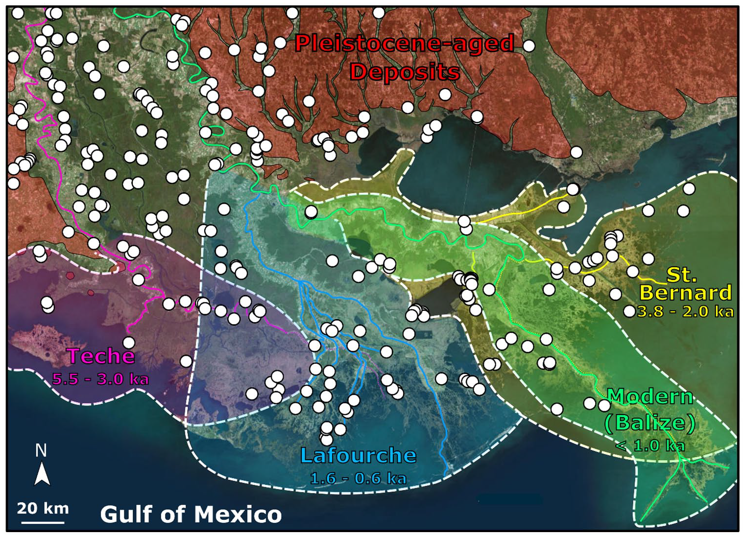
Relationship of archeological sites to delta landforms. Pleistocene-aged deposits are indicated by red shading (Snead and McCulloh, 1984). Holocene-aged delta lobes (Törnqvist et al., 1996) are outlined with white dashes and shaded, and channel networks are mapped using colors corresponding to the shaded lobe areas. The timing of subdelta activity (Hijma et al., 2017) is presented. Prehistoric mound and midden archeological sites (white circles) are found primarily along the natural levees of the lobe distributary channels and on the edge of Pleistocene terraces incised by Holocene rivers to create escarpments.
The need for research into human responses to environmental change is heightened in the Mississippi Delta because this landscape is undergoing rapid degradation. Land-loss amounting to 45 km2/year over the past century (Couvillion et al., 2017) has diminished the delta plain and wetlands of coastal Louisiana, while only minimal and isolated gains have occurred (Figure 1). The rates of Mississippi Delta land growth under optimal conditions may approach only 6–8 km2/year, meaning losses are likely to continue, rendering the delta plain unsustainable (Chamberlain et al., 2018). Despite novel 21st century nature-based engineering strategies (e.g. Xu et al., 2019), continued downsizing of the Mississippi Delta due to subsidence, erosion and canal dredging, and sea-level rise (e.g. Allison et al., 2016; Morton et al., 2006) is inevitable, and these land losses are coupled with the loss of the archeological sites they host. The losses seen in the Mississippi Delta can be anticipated in other deltas as relative sea level rise is expected to accelerate in the upcoming century.
Overview of the Mississippi Delta and its Archeological Archive
The coastal plain of present-day Louisiana has been inhabited by indigenous peoples for the entire Holocene epoch. The oldest archeological sites are generally limited and situated on or near Pleistocene-aged landforms (Gagliano and Saucier, 1963) (Figure 2). Examples include a middle Archaic mound known as Banana Bayou located on the salt dome of Avery Island (Brown, 2015; Russo, 1996; Saunders, 1994), the Watson Brake multi-mound complex of northern Louisiana (Saunders et al., 2005) and the UNESCO World Heritage Site of Poverty Point (Ellerbe and Greenlee, 2015; Gibson, 2007) located on the edge of a Pleistocene terrace of the Lower Mississippi River at its contact with the younger meandering river deposits of the Holocene system. Two round earthen mounds on the Louisiana State University campus in Baton Rouge were recently proposed to be among the oldest human-made structures in North America; this claim has received media attention (Rddad, 2020) although it has not yet been confirmed in peer-reviewed literature (Rodning and Rees, 2020). In all, early archeological sites of the Mississippi Delta reveal a relationship between prehistoric people and the coastal and fluvial waterways and demonstrate the longstanding and ubiquitous preference of humans to occupy relatively high-elevation and waterfront property that has been seen in other deltaic archeological sites (e.g., Donoghue and White, 1995; Holz, 1969; Louwe Kooijmans and Knip, 1974; Pierik and van Lanen, 2019; Politis et al., 2011) and continues in modern communities today.
The vast majority of the deposits that form the surface of the present-day Mississippi Delta are at most only ~3500 BCE (5.5 ka) in age and in many places much younger (e.g. Chamberlain et al., 2018; Hijma et al., 2017; Shen et al., 2015; Törnqvist et al., 1996; Figure 2). Because sites cannot be older than the land on which they were built, most Mississippi Delta archeological sites persisting today are Late Holocene in age. It is likely that people did inhabit earlier Holocene delta lobes (or, “subdeltas”), yet, these landforms and their undocumented archeological sites have been lost to the processes of subsidence and erosion associated with lobe switching. An analogous process of subdelta decline, exacerbated by modern human activity, is ongoing today in the Lafourche lobe (abandoned ~1400 CE, Chamberlain et al., 2018) and in portions of the Modern (Balize) lobe. This contributes to the loss of valuable and irreplaceable archeological archives in those regions (Britt et al., 2020). Like the earlier sites, Late Holocene cultural centers are preferentially located on high-elevation land near waterways (Figure 2), in essence, on the natural levees of “bayous” or past distributaries of the Mississippi Delta river network (Chamberlain et al., 2020; Mehta and Chamberlain, 2019).
The whole of the Mississippi River Valley is formed as a result of an embayment created by the retreat of the Laurentide Ice Sheet between the Appalachian Mountains and the Rocky Mountains. The Mississippi River is typically divided into Upper, Middle, and Lower sections – the Upper section begins with the river’s headwaters at Lake Itasca and ends with its confluence with the Missouri River near modern-day St. Louis, Missouri; the Middle section proceeds from St. Louis and terminates with the Ohio River confluence at Cairo, Illinois; the Lower section begins at Cairo and terminates in the Gulf of Mexico, at the mouth of the Mississippi River, which forms the Mississippi Delta. In this paper, reference to the Mississippi Delta connotes environments and portions of coastal Louisiana formed by the mouth of the Mississippi River and its past pathways, and the landscapes created where the river empties into the Gulf of Mexico. The colloquial usage of “Mississippi Delta” can also refer to the Yazoo Basin, a low-lying floodplain of the Mississippi River formed by ancient meandering courses of the river and that is bounded by Aeolian Bluffs to the East, Memphis to the north, and Vicksburg to the south. Our study area does not extend that far north, and consequently, we refer to the Mississippi Delta without ambiguity.
Archeological research has revealed information about the architecture, community structure, and ways of life of prehistoric peoples of the Mississippi Delta, and a classification of U.S. Gulf Coast occupational periods is provided by Rees (2010). Prehistoric archeological structures are often mounds constructed of local deltaic sands and muds, and middens of shells of the brackish-water mollusk Rangia cuneata. The archeological sites may host singular monuments or be multi-mound complexes. The earliest mound examples are often round in form, and later examples tend to be larger flat-topped or pyramid-shaped mounds sometimes featuring wood and daub structures at their summit, following similar architectural trends in the Lower Mississippi Valley and along the U.S. Gulf Coast (Neuman, 1984). The construction of earthen monuments represents significant labor and collaboration within prehistoric societies, and it has been proposed that establishing persistent monumental places corresponds to decreased seasonal mobility, more sedentary lifestyles, and enhanced resilience of prehistoric peoples (Rodning and Mehta, 2015). This cultural transition happened gradationally over millennia and distinctions between late Holocene cultures may be blurred rather than sharp. Nonetheless, relatively sedentary lifestyles likely became common by the Late Woodland period, circa 500 CE (1.5 ka) (Mehta and Chamberlain, 2019; Rodning and Mehta, 2015). Populations are thought to have lived in a dispersed arrangement around the mounds, reflecting social differentiation and hierarchy (Rees, 2012).
Artifacts recovered from within the mounds reveal information about prehistoric lifestyles and cultural exchanges. Both ceramic motifs and mound architecture suggest trade networks horizontally along the U.S. Gulf Coast (i.e. east-west) and vertically up the Lower Mississippi Valley (i.e. north-south) (Davis, 1981; Mehta and Chamberlain, 2019; Mehta et al., 2020; Neuman, 1984; Rees, 2010). Prehistoric peoples were largely hunter-gatherers prior to 1200 CE (0.8 ka), subsisting on the abundant flora and fauna of the delta including deer, alligator, eastern box turtle, garfish, largemouth bass, catfish, mallard ducks, great blue herons, egrets, hickory nuts, pecans, acorns, persimmons, and palm and palmetto fruits that provided year-round food resources (e.g. Fritz, 1990; Mehta and Chamberlain, 2019; Figure 3). After 1200 CE (0.8 ka) agricultural crops such as maize appear to have become a minor component of the local indigenous diet (Fritz and Kidder, 1993).
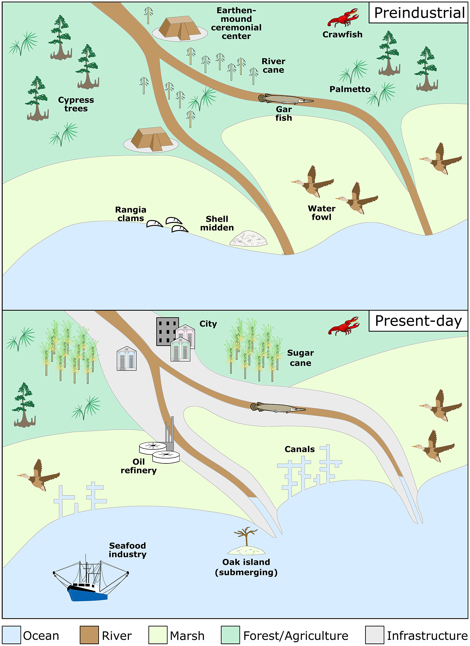
Past and present-day landscapes of the Mississippi Delta and the resources they provide. The Agricultural/forested zone (dark green) includes cypress (Cupressus sp.) trees, rivercane (Arundinaria sp.), palmetto (Sabal minor), and traditional foods such as crawfish (Procambarus clarkii and garfish (Atractosteus sp.) in swamps and waterways. Earthen mounds and archeological sites are common along elevated ridges and waterbodies. The coastal marsh zone (light green) hosts waterfowl alligators, crabs, saltwater fish, and shellfish like Rangia cuneata which was a dietary staple also utilized for mound-fill. Present-day conditions feature expanded infrastructure (gray) along waterways, replaced native habitat such as canebrakes with sugarcane plantations, channelized waterflow through canals, and eroded marshes. While many natural resources persist, human populations have increased, the shoreline has retreated, and canals have caused saltwater intrusion into wetlands which further degrade the coast.
This landscape of the Mississippi Delta has undergone substantial change since preindustrial times (Figure 3). After European contact, massive tracts of land along the Mississippi Delta were cleared primarily for sugarcane agriculture, significantly altering the landscape, in addition to large-scale deforestation associated with cypress (Cupressus sp.) logging (Figure 3). By the late-19th and early-20th centuries, oil and gas infrastructure, such as canals and channels, pipelines, and refineries further altered the delta landscape (Figure 3). Most significantly, gradually heightened and extensive impoundment of the Mississippi River by leveeing beginning with the western settlements and farms in the early 1700s and coming under federal regulation in the late 1800s fundamentally reduced the natural meandering and flooding processes of river channels (e.g. Barry, 2007). These changes in water management are contributors to the land-loss crisis in the Mississippi Delta because the impounded river is disconnected from its floodplain and therefore not effective at building new land to replace that lost to relative sea-level rise. Nevertheless, local communities, including Lower Mississippi Valley descendent Tribes such as the Atakapa, Chitimacha, and the United Houma Nation continue to call the region home and strongly identify with subsistence lifestyles tied to the natural resources and cultural heritage of the delta (e.g. Usner, 2021).
Early Investigations: A Story of Salvage and Preservation
Calls to preserve the Mississippi Delta’s archeological heritage began in the mid-late 1800′s, with both natural and anthropogenic threats to archeological sites being identified (Jeter et al., 1989; Neuman, 1984), similar to concerns raised today. Explorations of Louisiana archeology began through several Smithsonian-led expeditions during the 1920s, which were the first to link shell and earthen mounds found in the Mississippi Delta to the broader mound cultures of the Mississippi Valley (Collins, 1927; Neuman, 1984). During the Great Depression years of the 1930s, significant archeological work throughout the Lower Mississippi Valley was conducted as part of federally-sponsored public works projects through the Works Progress Administration (WPA) and other public works organizations (Figure 4).
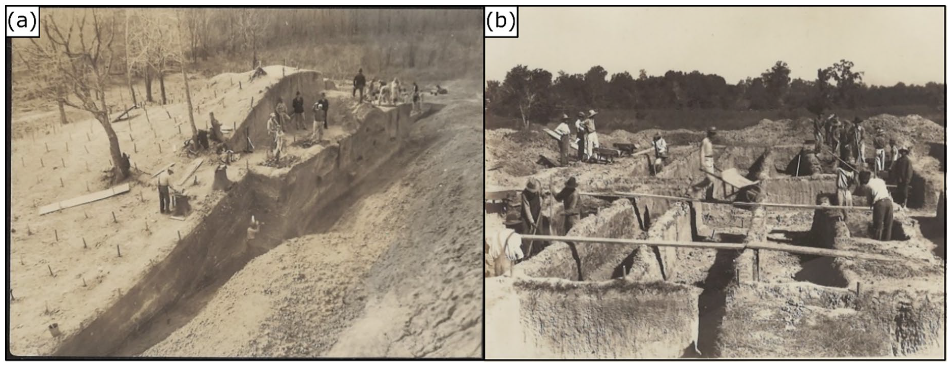
WPA-era excavations at the Crooks Mound site: (a) Early archeological research was often destructive and (b) yet the scale of such efforts is unmatched in recent decades (Photos courtesy LSU Museum of Natural History archives).
Projects of the time, for example at the Troyville Mounds along the Mississippi River in east-central Louisiana (Walker, 1936), at the Crooks site (Ford and Willey, 1940), and throughout the Lower Mississippi Valley (Ford, 1936) provided much-needed employment for local communities and were also the first major scientific archeological projects conducted in the region (Figure 4a). James Ford obtained state and federal funding primarily through the Smithsonian for up to 200 relief laborers to participate in WPA excavations (Lyon, 1982) who worked on survey, large area excavations, and laboratory analysis for sites throughout the Lower Mississippi Valley. Archeology public works projects were unique in that the discipline crosses a variety of skillsets, thus allowing for the hiring of a wide range of workers, including women (Lyon, 1996). Ford assigned the relief laborers extensive readings on archeology and the indigenous history of the region and entrusted them to perform not only excavation tasks but also technical archeology tasks such as artifact cataloging and ceramic classification (Lyon, 1982).
The works of the WPA (e.g. Cordell et al., 2013) and previous civil works groups resulted in the first chronologies and analyses of regional settlement patterns throughout the Lower Mississippi Valley (Ford, 1936; Phillips et al., 1951) and continue to provide key baselines for archeological studies today. However, these excavations were also very destructive in and of themselves, and in some cases, entire mounds were razed (e.g. Figure 4a). Nevertheless, the size and scope of these early projects (Figure 4b) and the level of governmental support they received has yet to be matched, providing clear antecedents for the potential of future coastal archeological restoration work which will require a similar scale of effort to document remaining sites before they are lost. The incorporation of local communities into the archeological research process is also an important component of contemporary coastal work, to help build stewardship among local communities and foster connections to the delta’s natural and cultural heritage.
The mid-20th century saw several noteworthy studies that surveyed the locations, conditions, and material cultures of prehistoric archeological sites in the Mississippi Delta, including early work by Kniffen (1936), McIntire (1958), and Gagliano and Saucier (1963). Unfortunately much of the mid-20th century research by necessity entailed “salvage” (see Britt et al., 2020) because many mounds were intentionally destroyed during this period to make way for subdivisions and industrial infrastructure prior to the passage of cultural resource protection laws. It was not uncommon for archeological studies of the period to extract as much information as possible using destructive methods (e.g. bulldozing trenches through mounds) from mounds that were scheduled to be flattened to accommodate municipal or industrial sprawl (Figure 4b). Still, these early works revealed new information about the material culture of Gulf Coast peoples. Some studies also suggested a connection between river activity, or lobe switching, and human habitation patterns (Gagliano, 1984; McIntire, 1958; Shenkel, 1984).
The mounds that persist today are in various states of preservation (Figure 5). Most surviving mound sites in Louisiana are located on private property, where preservation laws are limited. Some mounds, such as the Louisiana State University (LSU) mounds located on the institution’s main campus, are relatively well preserved in that they exist apparently intact, grass-covered, and are presently protected (Figure 5a) although it is unclear if artificial enhancements and alterations to the mound surfaces have been conducted over time. Others such as the Grand Caillou mound complex (Figure 5b) in the Lafourche subdelta have survived through landowner stewardship. Because ancient mound sites are some of the only elevated areas in the delta, they are also prime locations for intrusive historic and modern use, including as cemeteries at La Butte mound (Figure 5c) or as platforms for houses or fishing camps.
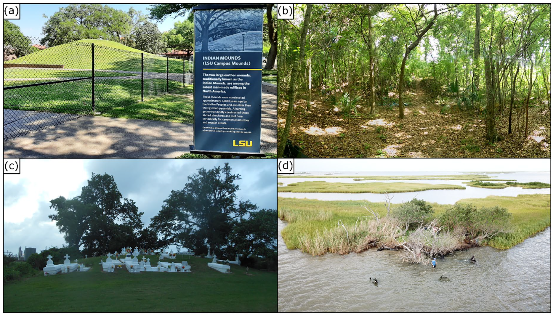
Prehistoric mounds in various preservation states: (a) LSU mounds, intact conical mounds with signage and a protective barrier, (b) Grand Caillou, an intact earthen pyramid mound on wooded private property, (c) La Butte, a disturbed mound intruded by a historic cemetery; lithology and original shape not well known because of the disturbance, and (d) Adams Bay mound, an earthen and shell mound that is rapidly being lost to submergence and coastal erosion. All within present-day southeastern Louisiana.
Mounds outside the engineered levee are extremely vulnerable to coastal processes associated with land loss. For example, the Adams Bay mound (Figure 5d) has become ground zero of salvage archeology and mound preservation efforts in the delta. The destruction of the mound can be witnessed in real-time, and satellite imagery over the past 23 years shows the trajectory from being completely intact and protected by a marsh buffer in 1998 to being partially submerged and actively eroded in 2021 (Figure 6). The Adams Bay Project (adamsbayproject.org) aims to salvage what remains of the site’s archeological record, and also works with Indigenous and local communities to illustrate the importance of vanishing coastal archeological sites to Louisiana’s cultural heritage through songs, documentaries, and other multimedia efforts. In all, these examples highlight the urgency of coastal archeological research before large components of the archives are forever lost.

A time series of satellite imagery taken of Adams Bay Mound showing the mound at the center in each photograph. Over a 23 years span from 1998 to 2021, the mound has progressed from being intact to almost completely destroyed by relative sea level rise and coastline retreat of >60 m.
Mid-Century to Present: A Wealth of Gray Literature
The largest source of archeological data produced for the Mississippi Delta over the past half-century comes from Cultural Resource Management (CRM) surveys (e.g. Altschul, 1978; Gagliano et al., 1979; Goodwin et al., 1990; Kelley et al., 2008), and surveys by the State of Louisiana (e.g. Mann, 2005; Neuman, 1977). By contrast, peer-reviewed scientific journal articles on this topic and region are relatively scant. Hundreds of state and private-company surveys cover tens of thousands of acres and have been largely effective in documenting site locations throughout the delta. These surveys are conducted as part of U.S. National Historic Preservation Act (NHPA) regulatory compliance, enacted in 1966, for American federal jurisdictional projects with a potential for ground disturbance.
Cultural Resource Management surveys typically entail shovel test probing and pedestrian survey along a grid (known as Phase I survey). These surveys focus on obtaining baseline information on site locations and determinations of site eligibility for the U.S. National Register of Historic Places (NRHP) and in turn, whether or not these sites meet the criteria for preservation and avoidance from ground-disturbing activities. As such, these surveys provide a wealth of data in terms of site locations and densities, but do not often provide fine-grained excavation-level information, such as site function, chronology, or analyses of the societies who lived in these places. Furthermore, CRM surveys are rarely geared toward addressing the academic research-scale questions needed to build theory relevant to broader fields of anthropology and delta land use histories.
Typically, excavation-level CRM work (known as Phase II-III survey) is reserved for rare cases when adverse site impacts cannot be avoided, and mitigation or salvage efforts are required. Survey information is archived by the Division of Archeology of the State of Louisiana (www.crt.state.la.us/cultural-development/archeology/) in the form of survey technical reports and site record forms that are maintained in an online database available to archeologists and researchers upon request. There is also an extensive collection of artifacts produced from CRM surveys which are curated at various state and federal offices; however, there is not yet a database where centralized artifact data are available.
The vast source of gray literature produced by CRM surveys is underutilized in academic research. Yet, it can be valuable for refining understandings of settlement patterns throughout the delta as well as sites in the most danger of being lost to subsidence and sea level rise. For instance, Chamberlain et al. (2020) utilized Louisiana site record forms to obtain new age constraints for archeological sites situated on a well-dated lobe of the Mississippi Delta, discussed further below. In a larger regional example, Anderson et al. (2017) consulted site records throughout the southeastern United States to interpret the number of archeological sites that will be lost at varying levels of sea level rise. They utilized the Digital Index of North American Archeology (DINAA), a linked open-source database which includes site information from various academic, federal, state, and Tribal databases and resources (http://ux.opencontext.org/archeology-site-data/). Their study revealed that 1 m of eustatic sea level rise would result in the loss of over 13,000 archeological sites, and a 5 m of rise would increase the loss to more than 32,000 sites along the Gulf and Atlantic coasts in the southeast (Anderson et al., 2017).
A key challenge and opportunity for growth of the disciplines of archeology, anthropology, and landscape management (among others) lies in a better coupling between non-academic CRM surveys and academic-scale research. The former provides region-specific data in higher detail and with greater coverage than possible with most academic research budgets, while the latter can synthesize this information to advance theory and provide solutions to global-scale questions. We propose several solutions for improving the dissemination and integration of archeological data:
Increased accessibility and linking of state and federal databases to facilitate research and broader comparative studies.
Engaging libraries to aid in cataloging gray literature for dissemination.
Incentives from public funding entities or academic partnerships (e.g. through graduate student programs) for CRM companies to publish research.
Better integration with local communities and the public (e.g. public exhibitions, interpretive signage, site visits), who as taxpayers fund the majority of archeological projects.
Cataloging and curation of collections to facilitate research on legacy datasets, such as university, state, and government agency artifact collections.
Increased awareness, accessibility, and promotion of CRM survey information and databases for researchers is the primary step toward more effective archeology in the Mississippi Delta and elsewhere. In addition, academic researchers must take action and actively search for and work with practicing professionals who, by virtue of the consulting work, have in-depth knowledge of the region’s gray literature. There are vast legacy datasets and collections at government offices and universities which have not been adequately cataloged and analyzed.
As a caveat, caution must be taken when utilizing gray literature reports, site record forms and various databases comprising non-peer reviewed field data because interpretations of site ages are often made with limited data and many site record forms are incomplete or outdated (Chamberlain et al., 2020). Moreover, any efforts to publicize archeological data must be made with caution to balance data accessibility with site confidentiality, and should be done in consultation with associated American Indian Tribes.
As Anderson et al. (2017) note, it will be crucial to identify what research questions remain unanswered that at-risk archeological sites can provide, at both regional and local scales, as we consider salvage and mitigation strategies and the prioritization of sites to research. However, in many cases there may be little choice in terms of which sites are selected for research because CRM projects are dictated by Areas of Potential Effect (APE) associated with development projects. As such, many of these projects aiming to address larger regional research questions will need to be undertaken by federal or academic research outside of the CRM framework, which will require more significant investment from universities, private partners, tribal, state and local governments, non-governmental organizations (NGO’s) and grant-making agencies.
Into the 21st Century: Coupled Natural-Cultural Systems
Archeological research into the Mississippi Delta and coastal restoration will benefit from a more thorough understanding of the delta as an integrated natural and cultural system. This is now feasible due to new theoretical frameworks for human-landscape dynamics in addition to advanced scientific methods for landscape reconstruction.
Socio-ecological systems (McGinnis and Ostrom, 2014; Ostrom, 2009; Walker et al., 2004) and ecosystem services (Assessment, 2005) are recent conceptual frameworks increasingly utilized for landscape management and ecological restoration. As noted by Liu et al. (2007), while human-environmental interactions have been extensively researched, understanding those interactions within a uniform, coupled system with associated feedbacks are still under-developed. Socio-ecological systems frameworks argue that differing languages and concepts across disciplines, primarily between the natural and social sciences, have led to an exacerbation of disciplinary siloes, thus limiting progress in addressing land sustainability and related issues (Ostrom, 2009). This has also been historically the case in the Mississippi Delta, where archeology is not often included in studies of coastal dynamics, nor in land management planning outside of the regulatory compliance process discussed earlier.
Traditional and indigenous knowledge systems have always integrated the natural and cultural worlds, and western-based scientific inquiries are now working to dissolve this barrier. In many indigenous worldviews this concept is referred to as kincentricity, the belief that humans and nature share common origins and ancestry and are part of a collective ecological family (Salmón, 2000). Traditional Ecological Knowledge (TEK) has developed over the past two decades to scientifically acknowledge and study the wide body of knowledge local and indigenous communities possess in terms of humans and landscape histories (Berkes et al., 2000). Studies of TEK have led to breakthroughs in landscape restoration, most notably a better understanding of indigenous fire ecology associated with prescribed burning and forest management practices that improve habitat, reduce wildfire risk, and support natural and cultural resources (e.g. Senos et al., 2006).
In the Mississippi Delta, TEK has been utilized in conjunction with Geographic Information Systems (GIS) data to improve restoration management decision-making (Bethel et al., 2011, 2014). Bethel et al. (2011) studied the indigenous Atakapa community of Grand Bayou in coastal Plaquemines Parish, who continue to live primarily from delta ecological resources. The Atakapa were able to contribute integral information associated with land use and loss over time, represent that information geospatially, and identify high-priority restoration areas such as sacred cultural sites and critical habitat areas. Subsequently, Bethel et al. (2014) developed a model and toolkit for integrating conventional geospatial and TEK data to better represent land use histories and improve restoration priorities.
Advances in scientific dating methods have led to an improved understanding of Holocene landscape evolution that can be coupled with archeological investigations, thus improving the ability to understand environments such as the Mississippi delta as coupled human-natural systems. Such studies can be considered an extension of formative research by McIntire (1958) relating geographically zoned cultural groups to deltaic lobe switching by obtaining relative chronologies for archeological sites from their ceramics. Törnqvist et al. (1996) better developed this comparison by providing a new record of lobe initiation obtained from radiocarbon dating of underlying peat deposits. Mehta and Chamberlain (2019) performed a detailed excavation of a well-preserved earthen mound at the Grand Caillou archeological site, a multi-mound complex within the Lafourche subdelta that was in use from ~1200to 1400 CE (0.8–0.6 ka) (Figure 5 Radiocarbon dating of organic material within and directly underlying the mound was combined with optically stimulated luminescence (OSL) dating of clastic natural levee and crevasse splay deposits at the site to show that people constructed the Grand Caillou mound after the landscape had become naturally elevated by overbank deposition.
Building on this observation, Chamberlain et al. (2020) refined the chronology of 36 prehistoric archeological sites in the Lafourche sub-delta using a recently published high-resolution OSL chronology of shoreline progradation. They showed that prehistoric people moved with the river, inhabiting a new lobe 200–400 years after the land emerged from open water and abandoning that lobe when the river network moved to create a new depocenter. These studies highlight the potential of 21st-century research to integrate across archeological and geological perspectives and to use geochronologic tools to gain new insights into human-landscape dynamics.
Connecting Research to Policy: Ecosystem Services
The challenge now lies in integrating such knowledge into present-day landscape management and coastal restoration approaches in a way that serves present-day communities including those of indigenous peoples. The ecosystem services framework provides a means of bridging this gap. Ecosystem Services are an integrated natural-cultural analytical framework used to tabulate the natural and cultural benefits that an ecosystem may provide to humans, with the goal of identifying synergies and trade-offs among various services (Figure 7). The ecosystem services provided by archeology and cultural heritage, however, are still poorly understood (Helmer et al., 2020; Hølleland et al., 2017).
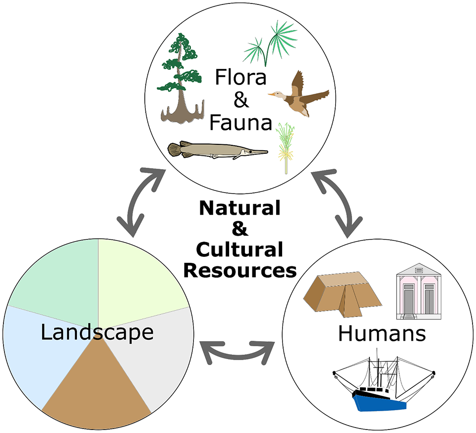
Ecosystem services framework. Ecosystem services describe and compare the benefits and feedbacks between the biophysical and cultural elements depicted in Figure 3 as one cohesive system.
As illustrated earlier, the history of Mississippi Delta archeological research has primarily been driven by preservation, mitigation, salvage, and knowledge discovery motives. Efforts to expand the size and scope of delta research in the face of coastal land loss would be well-served to better articulate the benefits that archeology and heritage provide to both ecosystems and the public (e.g. Byrd and Neuman, 2010). This has been made even more apparent through recent controversies over large-scale land modification plans, such as sediment diversions (e.g. Xu et al., 2019), which may bury archeological sites and affect traditional livelihoods. One method of better understanding heritage benefits provided by the Mississippi Delta is to survey local communities about their relationship to archeological sites and other heritage-associated aspects of the landscape, as well as their connection to biophysical ecosystem benefits to better understand how they link together. Most of the cultural and biophysical ecosystem services offered by the delta today trace back to pre-contact times and have shifted and adapted in response to industrialization (Figure 3).
Human ecology mapping is an effective way of measuring the benefits of an ecosystem (Helmer et al., 2020) by representing socio-spatially how those benefits manifest themselves on the landscape and compare with the environment. This information can be used to better incorporate archeology and cultural heritage into coastal restoration management strategies and overall ecosystem resilience. It can also enhance knowledge and stewardship of the archeological past because it provides a means of weighing the synergies as well as competing interests of various factors involved in landscape management (e.g. land-building potential versus disturbance caused by sediment diversions) as they relate to biophysical and cultural ecosystem services that the Mississippi Delta provides. Both native and non-native communities in the delta share strong connections to the land and its resources. Illustrating how those connections span millennia through common connections to delta resources and place will be an important tool to empower local communities and improve buy-in of archeological research and preservation moving forward.
Synthesis and Outlook
As we approach 100 years of scientific archeological research in the Mississippi Delta, a review of the past century of research shows that a concern of resource loss has continued to drive research since its inception. Deltas, especially the Mississippi Delta, are rarely static fixtures on a landscape. As such, humans and our research foci must adapt and change as well. Archeology remains a primary source of information about Mississippi Delta lifeways for over 90% of the Holocene delta’s human history and shows that the chronology of human activities largely correlates with deltaic land growth and modification over time. Earthen and shell monuments remain the most permanent, visible reminders and chronological markers of these societies within an impermanent landscape, and these mounds plus their associated material culture are rapidly being lost to coastal subsidence, erosion, and sea level rise – the same processes that threaten Mississippi Delta communities today. In many ways, the Mississippi Delta serves as a “canary in the coalmine” to other regions around the world, as a warning of what can be expected when archeological remains and other cultural ecosystem services are faced with rapid landscape destruction.
This article offers an overview of the history of Mississippi Delta archeological research, beginning with early explorations and large state-sponsored projects of the early 20th century that aimed to salvage archeological remains prior to industrial development, resulting in the first chronologies and general understandings of land use history. We argue that the scale of these projects and their local, state, and national level of support are needed once again to tackle today’s challenges of a rapidly vanishing archeological record.
The passage of the U.S. National Historic Preservation Act in 1966 paved the way for regulatory compliance-focused archeological surveys that have documented the majority of known sites in the delta over the past 50 years. These data have been underutilized, yet some recent studies demonstrate their value for answering key questions about landscape histories, settlement patterns, at-risk archeological sites, and coastal salvage strategies. We offer recommendations to better utilize these valuable and widespread data.
Moving forward, we advocate for a more thorough integration of archeological research within emergent theory on coupled natural-cultural systems, to inform both land and human histories and the reciprocal relationships between humans and deltas. Natural-cultural systems can be articulated in terms of the ecosystem services that deltas provide, including archeological and cultural heritage services which connect local communities to place. Such an approach will be critical for future adaptations to unprecedented rates of sea level rise in densely populated coastlines, for the 21st century and beyond.
Footnotes
Acknowledgements
Deep thanks go to Irene Martí Gil with the LSU Museum of Natural History who researched and digitized the WPA-era excavation photos and to Jakob Wallinga for critical feedback on a draft of this work.
Funding
The author(s) received no financial support for the research, authorship, and/or publication of this article.