
Abstract
The coastlines of the southwestern Pacific are dynamic environments that have been repeatedly reshaped by tectonic forces as well as changing global climate and sea level. It has been theorized that much of the north coast of New Guinea was sparsely inhabited until stabilization of coastal flats fallowing the Mid-Holocene Thermal Maximum and resulting marine high stand. We report on environmental proxy indicators measured in core samples taken near modern day Aitape, Papua New Guinea. These cores record the formation of a large lagoonal system on the modern coastal flats by 5800 cal BP. This lagoon infilled over the next several 1000 years as sea level dropped, with the modern coastal flats stabilizing by 1400 cal BP. A charcoal record spanning the period between 6200 and 1400 cal BP documents substantial increases in influx between ~6200 and 6000 cal BP and particularly from ~3000 to 2600 cal BP. Comparison to regional charcoal and ENSO records suggests that increasing aridity and ENSO intensity may drive regional patterning in fire records, however, localized charcoal records are also heavily influenced by human activity. Between 3000 and 2600 cal BP, forest management practices in the Aitape area, currently focused on tree crops and horticulture characterized by long fallowing and limited burning, shifted to a regime characterized by large scale forest clearance and shorter fallowing. We hypothesize that increasing population driven by abundant Mid-Holocene lagoonal resources may have been difficult to maintain as lagoons infilled and climate became more variable, leading to horticultural intensification.
Introduction
Anthropogenic climate change has in recent years rekindled interest globally on the impacts of past environmental change on human society. In the Pacific Islands, this is of particular concern given that a large percentage of the region’s inhabitants live within a few meters of current sea level (Andrew et al., 2019). While the drivers of climate change and sea-level rise may have changed, people occupying the coastlines of Pacific Islands have contended with dynamic environments since the time of first settlement (Goff et al., 2017). The presence or absence of viable coastal ecologies has been one of the primary factors influencing the pattern of island settlement in Oceania. This factor has been linked to the earliest movement of H. sapiens across Wallace’s Line from Sunda to Sahul during the Pleistocene (Allen and O’Connell, 2020) as well as later movements between ISEA and the SW Pacific (Terrell, 2004a, 2004b) and early settlement of the Remote Pacific (e.g. Cochrane et al., 2016).
On present evidence, the island of New Guinea (the second largest in the world with an area of ~178,000 km2) was first settled by ~45–50,000 cal BP, although earlier dates of 70,000 cal BP have been suggested (Allen and O’Connell, 2020). Most evidence for early occupation comes from the rugged interior highlands (e.g. Summerhayes et al., 2010, 2017). Despite the necessary coastal focus of early settlers, tangible archeological evidence for lowland and coastal settlement at present is ~5–10,000 years later than for the highlands (Groube et al., 1986; O’Connor et al., 2011). The degree to which the occupants of Pleistocene Sahul remained socially and biologically connected to Sunda remains unclear, but generally speaking, there is little evidence to suggest significant movement between the two regions until after the Mid-Holocene (Torrence and Swadling, 2008). It has been hypothesized that stabilization of global sea-levels during the Mid-Holocene should have resulted in significant increases in population density along the coastal margins of New Guinea, particularly on the island’s northern coast (Gosden, 1995; Terrell, 2004a, 2004b). The presence of larger populations on the north coast may in turn have influenced the emergence of long-ranging social connections during the Mid-Holocene (~7000–3000 cal BP) (e.g. Shaw et al., 2020; Swadling, 2005). Yet there remain large gaps in the radiocarbon record for most of northern coastal New Guinea, including the entirety of the Mid-Holocene. It remains unclear whether this lack of tangible dated evidence for settlement reflects the absence of people along much of the north coast, or the difficulty of finding archeological sites in a highly dynamic landscape for much of the post-glacial period (O’Connor et al., 2017).
We report the results of palaeoenvironmental fieldwork in the area around modern-day Aitape, Papua New Guinea (Figure 1). Aitape is located on one of the largest modern coastal flats on the north coast of the island. Proxy indicators measured in cores taken some 2 km inland from the modern coastline document the evolution of this coastal flat during the last ~6600 years, beginning after the Holocene Thermal Maximum (HTM, ~7000 cal BP) ( Renssen et al., 2012) when after a period of marine inundation, a large brackish lagoon existed in areas that are today seasonal backswamps. This large lagoon began infilling by ~5500 cal BP, but may have been locally present for several 1000 years after this. The present ground surface may have stabilized as early as 2000 years ago in some places, while in others, infilling continued until relatively recently. Rapid Mid-Holocene deposition likely accounts for the virtual invisibility of Mid-Holocene archeology in the region, and likely accounts for enhanced visibility of sites during the last two millennia. Periodic significant increases in charcoal influx during the Mid-Holocene are likely linked to changes in subsistence strategies associated with increased population that also contributed to landscape evolution and environmental change.
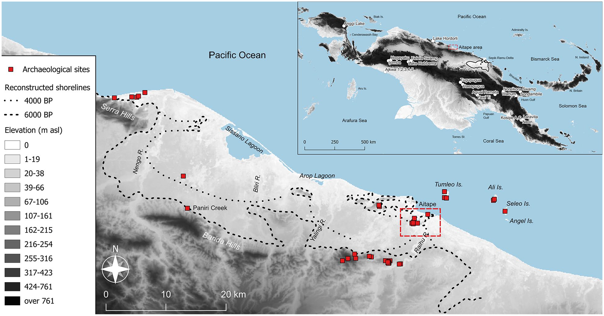
Map of Aitape area of northern New Guinea showing possible paleoshorelines as reconstructed in Terrell et al. (2011) and locations mentioned in the text. The inset map shows the location of Aitape on New Guinea as well as the maximal extent of the Sepik-Ramu inland sea c. 6000BP. The inset also shows the location of comparative charcoal records used in this study. The area inside the dashed red box on the main map is shown in detail in Figure 3.
Northern coastal New Guinea
Compared to the major highland and inland riverine valleys (where population densities may reach 30–300 persons/km2), much of coastal New Guinea is currently sparsely populated. On the island’s northern coastal margins, densities average ~1 person/km2. People today cluster around river mouths and estuaries, as well as small coastal lagoons rich in protein resources. Owing to the steep continental shelf that defines the boundary between the Australian and Pacific tectonic plates, the north coast of New Guinea has few reefs or mangrove swamps at present. Instead, most people living there combine extensive arboriculture (sago, nut trees, and coconuts) with limited taro horticulture and low intensity tending of chickens and pigs. The later are considerably less important to subsistence (and related cultural and economic practices) than in other parts of New Guinea (Bourke and Allen, 2009).
Earliest evidence for occupation on the north coast presently dates to between ~36 and 42,000 cal BP at Latchitu Cave (near the modern PNG/Indonesian border, O’Connor et al., 2011) and further to the east on uplifted coral terraces in the Bobongara area of the Huon Peninsula (~40,000 cal BP, Groube et al. (1986)). These dates are the only currently known from prior to the LGM. Figure 2 shows all published radiocarbon determinations for the north coast after the LGM. As can be seen, there are notable C-14 gaps during the Late Pleistocene, but it is not clear whether this reflects more general population trends, or simply gaps in the use of the handful of Vanimo area cave sites from which these late Pleistocene dates are derived.
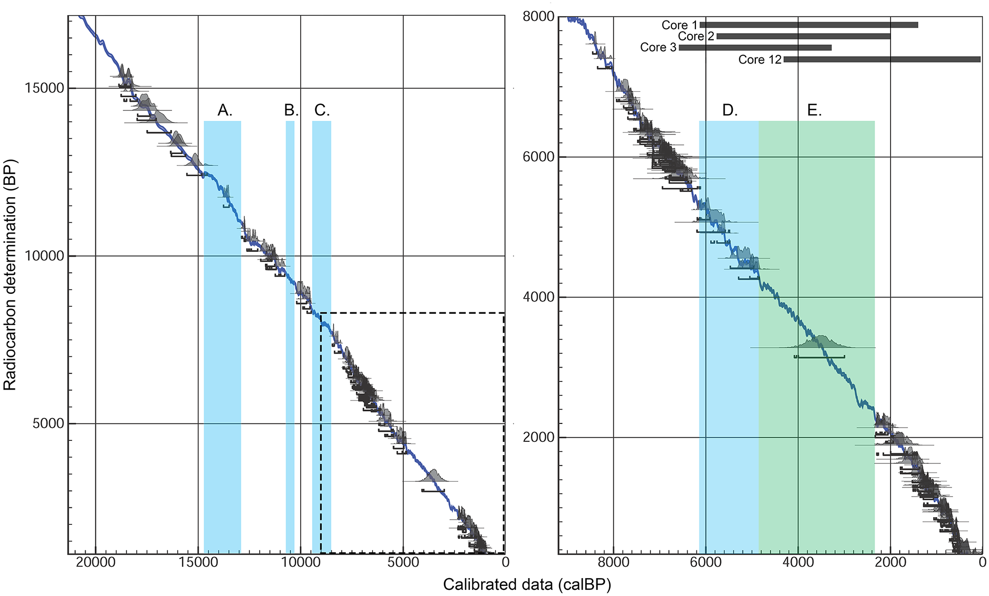
Compiled radiocarbon determinations from sites on the north coast of New Guinea after the LGM (left), and for the Holocene (right). Gaps are present in the radiocarbon record at (a) ~14,500–13,700 cal BP. (b) ~11,400–11,100 cal BP. (c) ~9400–8300 cal BP. During the Holocene, there are few dates during (d) ~5900–4800 cal BP, and only a single determination for the period (e) ~4800–2100 cal BP. Dark gray bars indicate the estimated chronological range present in the sediment cores reported here. All published dates were recalibrated in OxCal v.4.4 using the IntCal20 calibration curve.
Far more dates are available for the north coast after the onset of the Holocene, and particularly after ~8300 cal BP. Again, many of these early Holocene dates derive from Vanimo area rock shelters, but suggest more regular and/or longer-term occupation. There is also a relatively rich C-14 record for the period after 2100 cal BP, for which numerous sites are known extending from the modern PNG/Indonesian border to the Huon Peninsula/Vitiaz Straits to the east. There is a conspicuous gap in the C-14 record during the Mid-Holocene, particularly between ~5900 and 2100 cal BP (see Figure 2). At present, the only date falling into the period between ~4800 and 2100 cal BP comes from the Anakari shell midden (3280 ± 200 BP, 4080–2996 cal BP), in the modern Sepik-Ramu delta. However, this date comes from a potentially disturbed layer in association with far earlier shell dates (Swadling et al., 1991). Like other middens in this region, during the Mid-Holocene, Ankari would have been along the shores of a large brackish inland sea extending up the Sepik River Valley as far as the modern Chambri Lake (Chappell, 2005; Swadling, 1997).
Despite a lack of well-contextualized archeological data, there is some evidence to suggest that this gap in the settlement record may be more evident than real. While the Mid-Holocene is conspicuously absent in the stratigraphy of Vanimo area rock shelters, O’Connor et al. (2017) have identified remnant breccia deposits on cave walls, and suggest erosion may have removed portions of the stratigraphy. Characteristic stone mortars and pestles, recovered from numerous locations along the north coast, are of Mid-Holocene production (Shaw et al., 2020). Along with the widespread distribution of obsidian stemmed tools produced primarily from sources on New Britain (Torrence and Swadling, 2008), the Mid-Holocene increasingly appears to have been a period during which more intensive and regular movement and interaction occurred along the north coast of New Guinea and its major offshore island archipelagos.
Terrell (2004a) likens New Guinea to a “sleeping giant” during much of the Pleistocene, arguing that unproductive coastal environments during periods of lowered sea-level constrained coastal population densities, and in turn made voyaging along its shores unattractive to people living either inland, or further to the west in Wallacea and Sunda. As a result, the island formed a barrier to movement between those areas and the island archipelagos of Near Oceania. Terrell (2002) and Gosden (1995) have suggested that the development of productive lagoonal and estuarine environments along the north coast as sea-levels declined from their early Mid-Holocene high stand (estimated at ~7000 cal BP) may have fostered rapid population growth and related increases in mobility and interaction (see also Bailey and Parkington, 1988). The lack of archeological visibility during this period may therefore reflect changes in landscape usage and settlement location rather than depopulation. To summarize what Terrell (2002, 2004b) has labeled the “sleeping giant/ancient lagoons” hypothesis:
During much of Pleistocene, global sea-levels were much lower than at present. On the north coast, with limited continental shelf, lowered sea levels resulted in deeply incised river channels and rocky coasts with low biomass available for human exploitation. Consequently, population levels were limited. Gaffney et al. (2021) suggest that permanent settlements were absent, with only seasonal movement to coastal areas from interior valleys. The net effect may have been limited anthropogenic impacts on coastal environments, but also limited coastal movement and consequent relative isolation of the island from Wallacea and ISEA (Terrell, 2004a, 2004b).
During much of the early- to early-Mid-Holocene (c. 10–8000 cal BP), sea levels rose and eventually overshot modern levels following the HTM peaking at between 1 and 2 m above present levels by ~6500 cal BP (Chappell, 2005). As sea levels began to recede, large brackish lagoons and rich estuarine environments formed, covering much larger areas of the coastal flats than at present, as well as the before mentioned Sepik-Ramu sea. This period of optimal ecological conditions witnessed large-scale and more permanent settlement, fostering the establishment of wide-ranging social networks. These networks were in part a response to increasing risk exposure fostered by coastal living, where newly established communities would have been exposed to tectonic-driven disturbances (tsunamis) (Goff et al., 2017) as well as increasing climatic variability in response to the intensification of the El Niño-Southern Oscillation (ENSO) during this time (e.g. Moy et al., 2002).
After sea levels stabilized (~6000 cal BP), reduced river gradients contributed to progressive infilling of lagoons and northward progradation of the coastline. Sediment coring evidence indicates that by 3500 cal BP, the Sepik-Ramu inland sea had transitioned into a large freshwater lake, and continued infilling until ~1000 cal BP, when the current Sepik-Ramu Delta stabilized (Chappell, 2005). After this period, population levels likely declined to levels more akin to those present today.
While this model is consistent with known data regarding the environmental history of the north coast, there remain a number of questions regarding its validity. While ancient sea levels are well understood, the impact of tectonics on coastal morphology and resulting environment are less well understood (Chappell, 2005). Estimated uplift rates vary widely across the coast, ranging from 1.5 to 3.5 mm/year on the Huon Peninsula (but with evidence for periodic subsidence) (Tudhope et al., 2000) to 5 mm/year at Biak Island (Ellison, 2005). Other variables include the impacts of long-shore currents and impact on formation of sandbars and transport of sediments. Consequently, it is not certain how accurately the historical evolution of coastal environments has been modeled or how widely sequences documented in one location express general trends along the New Guinea north coast. Secondly, present data provides little concrete evidence for how people responded to Holocene landscape and environmental transformations. It is unclear therefore whether modeled increases in Mid-Holocene population actually occurred, as well as how people living there responded to rapid environmental shifts in terms of resource usage, forest management, or engagement with other communities elsewhere in the region.
The Aitape area
The work reported here was conducted as part of a larger project examining the archeology of the area around modern Aitape. Aitape is situated on one of the largest coastal flats on the north coast, extending some 14 km from the base of the Bewani/Torricelli range to the present coastline (Figure 1). At present, the Aitape area is characterized by extensive backswamps dotted with limestone hills reaching up to ~150 m in height. These hills are remnants of Miocene island arcs that have been accreted to the New Guinea mainland during the ongoing subduction of the Pacific plate under the Australian plate to the immediate north of the New Guinea mainland ( Pigram and Davies, 1987). Much of the immediate area behind the present shoreline consists of small lagoons, with larger lagoons present at Arop and Sissano to the west of Aitape. Prior to the founding of Aitape as a German administrative center, population in the area was focused around these larger lagoons or near to river estuaries, or else on the small offshore islands of Tumleo, Ali, and Seleo (Terrell et al., 2011).
Residents of the Aitape area currently rely on trans-generational management of sago stands and other fruit and nut trees including coconut, banana, canarium, and breadfruit, coupled with low intensity root crop horticulture. As on much of the north coast, taro is the most significant root cultivar, along with yam and sweet potato (which was absent prior to ~400 cal BP). These crops are grown on hillslopes and elevated well-drained plots, sometimes using low mounds to further control moisture. Long fallowing (15 years or more) of garden plots is currently typical, and unlike regions of New Guinea with higher population densities and/or more markedly seasonal rainfall patterns, burning is not regularly practiced during the clearing of new gardens (Bourke et al., 2002; Bourke and Allen, 2009).
Prehistory of the Aitape area
The earliest evidence for possible settlement of the region comes from undated finds of stone mortars and pestles, which have been found in a number of locations in and around Aitape, hinting at Mid-Holocene occupation (Swadling, 2021, personal communication). Additionally, two sherds of dentate stamped middle Lapita style (dated to ~3000 cal BP at sites in the Bismarck Archipelago) incised ceramics have been found, one at a place called St. Anna’s on the mainland, inland from Aitape, the other at Tubungbale, on nearby Ali Island. These finds represent the only evidence for settlement dating earlier than ~2100 cal BP. Numerous sites with ceramics dating after 2000 cal BP (and mostly after 1400 cal BP) are known in the Aitape area and on nearby islands. These ceramics were exchanged in both directions down the coast, reaching at least as far as the Serra Hills to the west and the Boiken area to the east (near modern day Wewak) (Golitko and Terrell, 2012). These more recent sites contain abundant evidence for exploitation of shellfish from a range of freshwater, brackish/lagoonal, and near shore environments as well as tending of pigs and chickens (Gerber and Schechter, 2011; Golitko et al., 2016; Stodder and Rieth, 2011), but to date little is known of the history of aboriculture and horticulture in the area.
Prior reconstructions of the Aitape environmental sequence
A preliminary reconstruction of the environmental sequence for the Aitape area by Terrell et al. (2011) used multispectral satellite data and digital elevation models to identify the presence of possible ancient landscape features. Bathymetry data indicates that at the LGM, the shoreline would have been only ~2 km further northward than at present owing to the steepness of the continental shelf (see the −120 m isobath on Figure 1). Rivers in the region would likely have drained toward the channel of the modern Yalingi River, which flows through a localized topographic low point. Rising sea levels after the LGM would have gradually decreased river gradients, and by ~7000–6000 cal BP, Terrell et al. reconstruct the shoreline near Aitape as running ~10 to 14 km inland from its present location near the base of the Barida Hills, with modern hills existing as nearshore islands (see Figure 1). By 4000 cal BP, sea-level recession would have formed two major lagoonal/embayment systems, the first a major open embayment inland from modern Sissano Lagoon, the second a more closed fronted by limestone hills immediately inland from modern Aitape. They suggest that after 3000–4000 cal BP, these lagoons and embayments began to infill, eventually producing the modern coastal morphology.
During 2014 fieldwork (Golitko et al., 2016), two of the authors revisited the Paniri Creek site first described by Hossfield during the 1920s (Figure 1). This location is now some 16 km inland from Sissano Lagoon at ~52 m asl, but some 6000–7000 years ago, was located nearer to the contemporary Pacific shore. Hossfield (1949, 1964) interpreted the site as evidence for a tidal scour in a mangrove swamp dated to ~5000 to 6000 cal BP, in which he found the so-called “Aitape skull,” the remains of a Mid-Holocene individual (Durband and Creel, 2011). However, analysis of paleoenvironmental proxy indicators and dating of bulk soil carbonate in sediment samples collected in 2014 suggests a revised reconstruction of the Paniri site. Basal sediments in the modern creek channel formed in a freshwater lake during the late Pleistocene and early Holocene (~16,000 to 7000 cal BC), which rapidly transitioned into a brackish lagoon following a significant tsunami event (which also led to the deposition of the “Aitape skull”) between ~6300 and 7000 cal BP. This lagoon was present at Paniri until ~4000 cal BP, after which extensive erosion likely associated with significant uplift infilled the lagoon margins. Sometime after ~1000 cal BP, the creek began to incise its present channel exposing older sediments. The Paniri sequence suggests uplift rates of ~7 mm/year during the last 7000 years, although possibly greater during the last 4000 years (Goff et al., 2017).
Material and methods
Coring
In order to expand environmental reconstruction for the region, during 2016, twelve sediment cores were sampled in areas south, east, and north of the base of Mt. Mario (one of the limestone hills south of Aitape – Figure 3). Logistical constraints prevented use of mechanized coring equipment, and a hand-turned bucket auger was used to collect 10 cm core sections down to a maximal depth of 4 m (the length of available auger extensions). Cores 1–3 were collected near the location of a core previously collected during the 1990s, which produced a Mid-Holocene date (5190 ± 40 BP/6173–5761 cal BP) at a depth of ~3 m in a layer of blue-green clay (Terrell, 2011b). Cores 4, 9, 10, and 11 were collected further eastwards along the southern edge of Mt. Mario. Core 12 was collected ~1 km to the south of Mt. Mario. Cores 5–8 were collected north of Mt Mario, ~0.5–1 km south of the modern shoreline. All cores were described and examined for texture and Munsell color in the field. All ~10 cm sample segments (excepting A-horizon samples in some cores) from cores 1, 2, 3, 5, 10, 11, and 12 were air-dried and then shipped to University of Notre Dame for further analysis.

Detail view of the Mt. Mario area showing location of known archeological sites, 2016 coring locations, and paleoshorelines as reconstructed in Terrell et al. (2011). Approximate dates for major coastal geomorphological changes documented in this study are noted. Satellite imagery from Google Earth.
Laboratory methods
Core samples were processed at the Notre Dame Department of Anthropology Archeology Laboratories. Each 10 cm core segment was manually disaggregated to separate out macro-organic remains, after which the remaining core material was air-dried. Core 1 was selected for more detailed analysis owing to the relatively high density of visible charcoal and datable macro-organic remains that promised the ability to develop a robust C-14 sequence. Portions of sediment from Core 1 were also sent to Power Paleoecology Lab at the University of Utah for pollen and charcoal analysis.
Radiometric dating
Selected organic and charcoal samples were sent to the University of Georgia Center for Applied Isotope Studies (CAIS) for AMS dating, using standard pre-treatment protocols to remove modern carbon. A total of five dates were obtained from Core 1, two dates from near the base of Core 2 (dates further up the core proved to be modern in age, likely roots), and single dates on larger organic remains recovered from Cores 3, 4, 5, and 12. All dates were calibrated using the IntCal20 curve (the northern hemisphere curve is generally considered more appropriate for New Guinea as it sits within the ITCZ for most of the year) in OxCal v.4.4. Bayesian age depth estimates for Core 1 were calculated in the rBacon package in the R statistical environment using 10 cm increments to approximate sampling resolution and default memory settings to model accumulation rates (Blaauw and Christen, 2011).
Geochemistry
Chemical concentration values in Cores 1, 2, 3, 5, 10, 11, and 12 were measured using a Bruker Tracer 5i portable XRF spectrometer housed at the Notre Dame Archeological X-ray Laboratory (NDAXL). Approximately 5 g of sediment from each core sample was oven dried at 100°C for 12 hours, then finely powdered in an agate mortar and measured into XRF sample cups sealed with Perspex analysis film. X-rays were generated from a Rh target, producing a 40 keV beam to excite mid-Z elements (Co, Ni, Zn, Rb, Sr, Y, Zr, Nb, Pb, Th), and a 15 keV beam for lighter elements (Si, S, K, Ca, Ti, Mn, Fe). Resulting photon peak heights were first calibrated using the instrument’s “Mud-Rock Dual” calibration, then corrected using a set of twelve NIST and USGS powdered rock and soil standards, with New Ohio Red Clay (NORC) used as a quality check standard. Repeat measurements on NORC suggest that error values are on the order of ~5% for elements reported here.
We utilize several proxy indicators to interpret conditions under which sediments were deposited. In the case of the north coast, sediment is likely to reflect erosion out of the Torricelli/Bewani range during periods of heavy rainfall. (Fe + Ti/K) is typically interpreted as reflecting a ratio between heavy mineral grains and lighter clay (illite) content, and is thus indicative of the energetics of weathering and sediment deposition (Davies et al., 2015). S and Sr are used here as an indicator of potential marine influence on coastal deposition (Goff et al., 2017), although elevated concentrations of either element could result from other causes, including biological fixation by micro-organisms (Davies et al., 2015). The Mn/Fe ratio is typically taken to reflect changes in oxygen content in a water column, with lower ratios reflecting higher precipitation of iron under anoxic conditions, but may also reflect changes in ground water movement during deposition. Finally, we use the ratio of Ca/Ti as an indicator of carbonate precipitation. Although Ca can be introduced via either erosional or organic processes, comparison of Ca content to both Ti and Sr allows these two likely sources to be differentiated (Davies et al., 2015; Evans et al., 2019).
Loss on ignition (LOI)
To estimate soil organic content, LOI (Heiri et al., 2001) was measured in Cores 1, 2, 3, and 12. Ceramic crucibles were heated to 100°C for 1 h in a muffle furnace to remove surface moisture, and weighed. ~4 g of powdered sediment from each core segment was then weighed into the crucibles, after which they were heated to 100°C for 12 h and weighed. Samples were then heated to 550°C for 6 h (volatilizing organics), then cooled to room temperature and weighed. Finally, samples were heated to 1000°C for 2 h (volatilizing calcium carbonate), cooled, and weighed (Neff et al., 2006).
Charcoal
To analyze evidence for fire activity in Core 1, we sampled for charcoal at contiguous sample increments, approximately every 15–20-cm of core. Each sediment sample interval was homogenized into approximately 7 g of material and placed into glass vials. Each vial was then subsampled for charcoal by extracting 1.0 cm³ of clay-rich sediment for analysis. A total of thirty samples were treated with ca. 10 ml of 10% potassium hydroxide in a hot water bath for 15 min and gently stirred and wet sieved through a 125 μm sieve. Charcoal pieces >125-μm were collected and transferred to a gridded petri dish and tallied under a reflected light microscope at 32–40× magnification. Charcoal fragments were identified based on their black color (partly charred particles were not counted) as well as the ease of breakage and shattering while under magnification. Simultaneously, charcoal fragments were categorized into charcoal morphotypes, including; woody, branched, fibrous or cellular. CharAnalysis software (Higuera, 2009) was used to determined charcoal accumulation rates (charcoal influx, CHAR) and the low-frequency trends (background CHAR). Additional metrics on peak magnitudes and fire frequency were omitted from our discussion in light of the aggregate sampling resolution.
Four charcoal morphotypes were identified in the Core 1 sediment samples (following the classification reported in Miebach et al., 2022) based on differences in overall shape, branching patterns and the presence or absence of cellular structure. Miebach et al. suggest cellular and fibrous morphotypes are likely produced from incomplete combustion of monocots (members of the Poaceae family) and herbaceous taxa. Morphotypes characterized as woody or blocky are likely from arboreal plant species.
Pollen
Pollen slides were prepared using standard procedures of Faegri et al. (1989). Pollen preservation in Core 1 was poor, with most samples found to contain few degraded pollen grains and most samples were devoid of preservation. This may result from both local soil conditions and known issues with pollen preservation in tropical environments.
Results
Macroscopic description of cores
Cores sampled near the southern base of Mt. Mario contain broadly similar sediment sequences (see Figure 4 for core 1, and Supplemental Figure S1 for remaining analyzed cores). In all of these cores, a thin A-horizon caps the upper 1–2 m of sediments, which consist of silty clay and silty clay loam with a mottled streaked appearance. Below this, sediments transition to variably sandy clays with a uniform gleyed blue-green coloration (see Supplemental Figure S2). In Cores 2, 3, 4, and 9, sand and loamy sand were hit at depths of between 250 and 400 cm below present ground level. This sand proved difficult (and sometimes impossible) to extract even using a “sand” auger bucket, and coring typically ceased upon hitting this layer. In Core 9 (not analyzed here – see supplement 2), ~50 cm of coarse sand were removed at which point limestone bedrock was encountered. Cores 10 and 11 grade from relatively fine sand to more gravely sand in their lower levels below about 250 cm depth. Dense layers of matted vegetation were encountered in both Cores 1 and 2 below 300 cm depth, similar to those encountered during coring in 1996 (Terrell, 2011b). Core 12 conforms to this sequence, but with a much shallower upper layer of silty clay and clay loam (~1 m), and a deeper sequence of gleyed clay (~3 m total). The bottom ~100 cm of Core 12 contains layers of variably coarse sand, sandy clay, and loamy sand. Additionally, parts of Core 12 contain relatively dense deposits of fragmented shell.
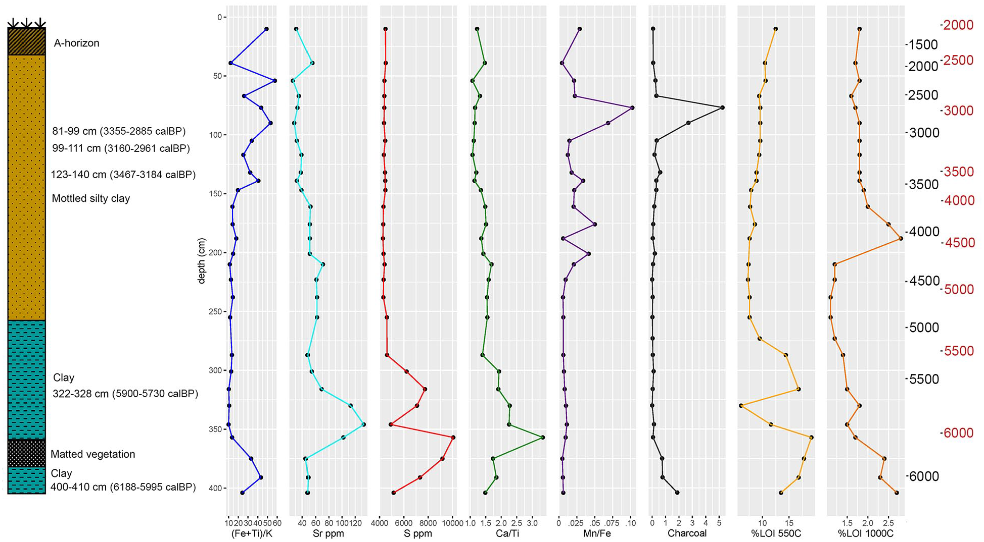
Stratigraphy of Core 1 and proxy measures for Core 1.
Cores taken north of Mt. Mario contain very different sediment sequences, and are generally far sandier than those collected south of Mt. Mario. Core 5, taken from the northern base of Mt. Mario, consists of clay rich sand and small pebbles directly over limestone bedrock, capped with a layer of fine sand, then loamy sand, and a thin A-horizon. The three cores taken to the north of Core 5 (6, 7, 8) all consist of ~1 m of gravely sand overlaying bedrock, and generally lack a well-developed A-horizon.
Dating of cores
Bayesian modeling of dates in Core 1 (Table 1 and Figure 5) suggests that the bottom of the core dates to approximately 6160 cal BP. The model is relatively well constrained from this point until 3000 cal BP, after which the lack of datable material in the upper segment of the core produces a wide range of potential date estimates. Median age estimates would date the upper most layers of the core to ~1400 cal BP while the maximal age estimates in the model would place the end of deposition nearer to 2000 cal BP. Both estimates are included on Figure 4, although we use the “median” age estimates for the upper portions of the core, which are consistent with the surface collection of ceramics known to be produced after this date (so-called “Sumalo Ware”). Based on model estimates, the deposition rate in the bottom 100 cm of core 1 is ~0.14 cm/year, dropping to ~0.085 cm/year between 300 and 100 cm. Median age estimates for the top 100 cm of the core suggest a deposition rate of ~0.0625 cm/year, while maximal age estimates would put this value closer to 0.1 cm/year.
Radiometric age determinations from cores.

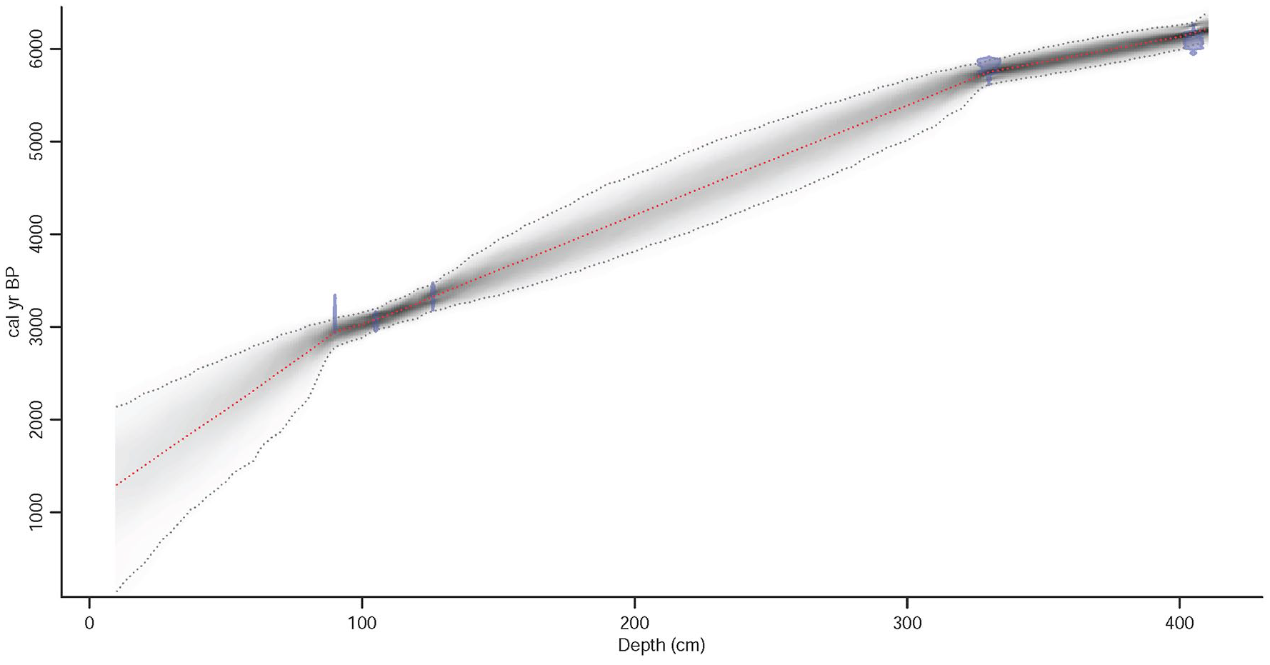
Age-depth model for Core 1 constructed using the rBacon package.
We do not have sufficient radiocarbon dates from other cores to construct formal Bayesian age-depth models, but have estimated ages based on the average deposition rate estimated from Core 1 anchored by the C-14 dates we do have for Cores 2, 3, and 12 (see Supplemental Figure S3). Core 2 appears to cover largely the same time span as Core 1, with the bottom of the core anchored by a C-14 date at just after 6000 cal BP, and the top of the core estimated at ~1500 to 2000 cal BP. Core 3 appears to cover a period starting somewhat earlier than Cores 1 and 2, with an estimated start date of ~6600 cal BP and a reasonably well constrained upper date of ~3500 cal BP. Core 12 is estimated to date between ~4400 and 500 cal BP (or slightly later). A single date from Core 4 dates the transition from sand to sandy clay there to ~4000 cal BP. A single date from Core 5 (taken from the upper portion of the lower level of clay rich sand and pebbles) dates the transition to fine sand there to just after 6000 cal BP.
Geochemistry and LOI
Cores south of Mt. Mario display roughly similar patterns of geochemical variability, allowing for the uncertainties in dating. The lower layers of cores 1, 2, 5, and 12 are characterized by generally low (Fe + Ti)/K ratios indicative of relatively low energy depositional environments, although this ratio is higher in the bottom 20 cm of Core 1. These same portions of each core have elevated concentrations of S and Sr, as well as high Ca/Ti ratios and low Mn/Fe ratios (anoxic conditions). In Core 1, this portion of the sequence has high LOI values for both organic and inorganic carbon, while corresponding values in Cores 2 and 3 are moderately higher in their lower segments, suggesting a low-energy, organic rich deposition environment. In levels modeled to date ~4000 cal BP, (Fe + Ti)/K values increase, and remain variably high through the remaining segments of these cores, as do Mn/Fe ratios. Sr, S, and Ca/Ti ratios drop off after ~5500 to 5000 cal BP, and remain uniformly low in higher segments of these cores. (Fe + Ti)/K ratios in Core 12 are similar to upper levels in Cores 1, 2, and 3, and are modeled to date to after ~4000 cal BP as well. However, the lowest levels of Core 12 have higher concentrations of Sr and S and higher Ca/Ti ratios unlike the pattern found in cores nearer to the base of Mt. Mario in core segments of similar age, and continue decreasing until ~2900 cal BP. LOI values in Core 12 steadily decrease with depth, also consistent with the upper portions of Cores 1, 2, and 3. Cores nearer to the eastern side of Mt. Mario (4, 9, 10, and 11) display marginally different textural and geochemical sequences than those closer to the Mt. Mario’s western end. Cores 10 and 11 have variable (Fe + Ti)/K ratios in lower units, coupled with high Sr and S content, with uniformly high (Fe + Ti)/K ratios associated with drops in Sr and S in upper core segments.
Charcoal
The charcoal record compiled in Core 1 displays two periods of significantly elevated fire activity. The first of these is present in the bottom 25 cm of the core, dating to ~6200 to 5800 cal BP. The second, occurring between about 75 and 100 cm depth, corresponding to ~3000 to 2400 cal BP, is much higher than the first charcoal peak. For much of the Mid-Holocene (5800–3000 cal BP) and later Holocene (2400–1400 cal BP), charcoal influx is relatively low in Core 1.
Discussion
Cumulatively, we interpret the data from cores as indicating the presence of a marine embayment south of Mt. Mario at 6600 cal BP that transitioned into a brackish lagoon after ~5800 cal BP. Our coring therefore broadly confirms the coastal morphological reconstructions presented by Terrell et al. (2011) shown in Figures 1 and 3, although we can now suggest more anchored dates for coastal evolution. A sandy spit along the southeastern and eastern edge of Mt. Mario separated this lagoon from the Pacific Ocean – a lack of dates from cores taken there (10 and 11) make it uncertain when the shoreline there began to move north and eastwards. The presence of relatively high Sr and S values into relatively shallow depths in these cores could suggest that the Pacific shoreline remained near to the eastern slope of Mt. Mario until relatively late in the documented environmental sequence. While Core 1 evidences infilling along the lagoon edge as early as ~5400 cal BP, evidence from other cores indicates that this lagoon may have existed for some time thereafter, even if its extent was reduced. The Mid-Holocene Pacific shoreline was near the northern base of Mt. Mario between 6200 and 5900 cal BP, but began to move northwards as sea levels declined. The area north of Mt. Mario experienced relatively little deposition as the sea receded. While beach sands in Core 5, immediately north of Mt. Mario, are covered over with a thick layer of loam, only a thin layer of loamy sand is present at the surface in the vicinity of Cores 6, 7, and 8, taken ~200–300 m further north. By ~1400 cal BP, the present land surface had largely stabilized. Near Core 12, some deposition evidently continued until relatively recently, possibly as the course of the Raihu River meandered across its newly formed flood plain, but sometime after ~500 cal BP, the Raihu down cut to its present channel and deposition on the coastal flats largely ceased as sediment was transported directly out into the Pacific.
Combined with our earlier work at Paniri Creek (Goff et al., 2017), the evidence presented here demonstrates the existence of large embayments and lagoons in the Aitape area in the period immediately after the Mid-Holocene Thermal Maximum, and possibly for several 1000 years thereafter. Whether this environmental sequence corresponds to population increases on the coastal flats near Aitape is less clear based on available evidence, and our results highlight the challenges of understanding the archeological record for the region, particularly outside of elevated rock shelters and caves. Archeology older than 1400–2000 years or so is likely to be deeply buried in places, and Mid-Holocene settlement on the coastal flats might be up to 3–4 m beneath the present land surface, as is the case elsewhere on the north coast. For instance, the Dongan shell midden, in the Sepik-Ramu delta, was buried under upwards of 3 m of sediment accumulated since the Mid-Holocene (Swadling, 1997). A fragment of a Mid-Holocene stone pestle was dug up somewhere on the Raihu Cattle Farm grounds at a depth listed as ~2 m below the current ground surface, hinting at Mid-Holocene archeological deposits near Aitape (Swadling, 2021, personal communication). However, the extent of occupation at this time remains unclear.
While the charcoal record from Core 1 may provide insights into some elements of forest management and landscape usage, it is possible that changes in burning frequency relate to shifts in rainfall patterns, specifically related to ENSO variance during the Mid- and Late-Holocene. To examine whether variance in burning might be driven by natural climatic changes, we first compare the Mt. Mario sequence to long-term trends in fire activity on New Guinea using 23 charcoal records from the Global Charcoal Database. Original charcoal data were transformed using standard procedures in Power et al. (2010) by calculating influx, standardizing those values with a Box-Cox power transformation and converting the values to z-scores using a base period of 1000–200 cal years BP. To create a composite curve for New Guinea each charcoal record was sampled at 20-year time steps without interpolation for missing sample intervals and then aggregated and smoothed using a lowess curve with a 100-year moving window. Confidence intervals were created through bootstrap analysis, 1000 times with replacement, with each record contributing to the overall composite signal.
We further compare the Core 1 charcoal sequence to a long-term precipitation record from Swallow Lagoon, Australia (based on δ13C measured in preserved M. quinquenervia leaves), the nearest available higher resolution rainfall record covering the period represented by the Mt. Mario cores. Precipitation variability there is well correlated with variability on the north coast of PNG (and far more so than comparable high-resolution records from South America), but also in general agreement with isotopic data collected from corals further east on the New Guinea north coast, as well as more geographically distant ENSO records (Haberle and David, 2004; McGregor and Gagan, 2004; Moy et al., 2002; Shao et al., 2020; Tachikawa et al., 2011; Tudhope et al., 2001). Collectively, these records show lower ENSO frequency during much of the Mid-Holocene with overall higher rainfall. Recent oxygen isotope work on gastropod shells in Lake Kutubu (in the southern highlands) also documents increased rainfall between ~5900 and 5000 cal BP (Long et al., 2020). ENSO frequency and intensity appears to have considerably increased after ~2600 cal BP with average rainfall levels during the later Holocene generally lower than during the Mid-Holocene.
The composite charcoal record (shown in gray on Figure 6, using all available data for New Guinea – see also Supplemental Table S1) shows clear similarities to the Swallow Lagoon rainfall record, particularly for the later Holocene. Reduction in fire activity just before 3000 cal BP coincides with a peak in rainfall at Swallow Lagoon, followed by a return to increased fire activity as dryer and more variable Late-Holocene rainfall patterns commenced at ~2600 cal BP. Higher rainfall levels between ~2000 and 1400 cal BP coincide with reduced fire, while dryer and more variable conditions from ~1400 to 600 cal BP correspond to a return to increased fire in the New Guinean records. The relatively wet and stable conditions of the Little Ice Age (~200 to 600 cal BP) are reflected in lower fire activity in the composite record, while the New Guinea fire history shows a maximum level of fire activity for the entire 7000-year record as rainfall declined during the last 200 years. A composite curve using only records from northern New Guinea (black line on Figure 6) by and large mimics patterning in the overall regional composite record, although overall variance in fire activity during the later Holocene in particular is less pronounced then for the composite record, and the northern New Guinean records shows an abrupt increase in fire around ~2700 to 2600 cal BP that is absent in the composite record. Collectively, these charcoal records suggest that at an island-wide level, the New Guinean charcoal record may be substantially influenced by shifts in precipitation and ENSO frequency during the Mid- and Late-Holocene.
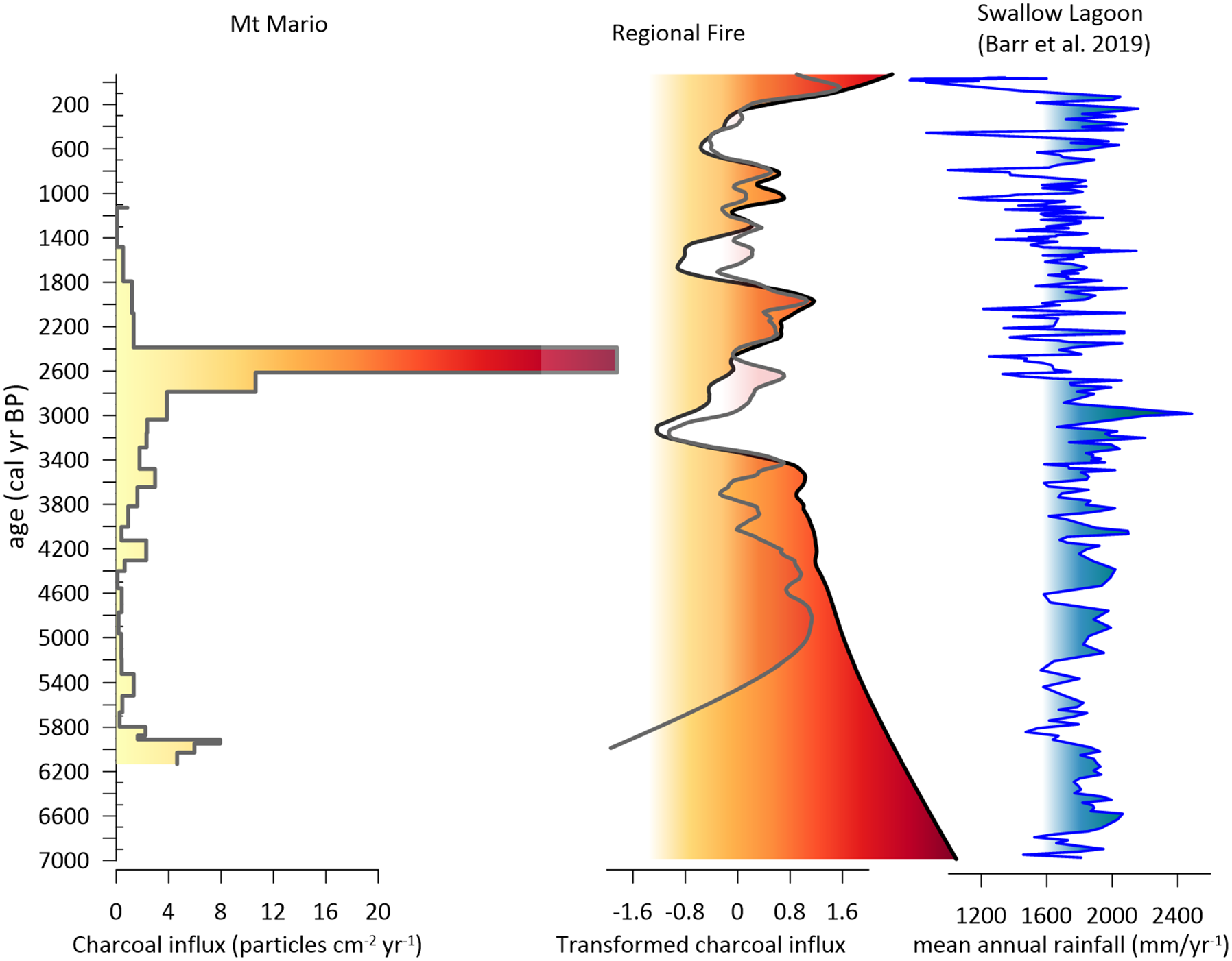
Mt. Mario charcoal record compared to summed normalized regional charcoal record and rainfall record recorded at Swallow Lagoon, Australia over the last 7000 years. On the regional charcoal record, the gray curve incorporates all records available for New Guinea, while the black curve only incorporates the six records from northern New Guinean contexts shown in Figure 7. Data obtained from the Global Paleofire Database (paleofire.org) and Barr et al. (2019).
However, individual charcoal records (Figure 7) show divergent patterns in comparison to the Mt. Mario core. There are no other comparable records from lowland contexts on the north coast itself. The geographically nearest charcoal record comes from Lake Hordorli near modern day Jayapura (Indonesian West Papua), at an altitude of ~2160 m. There, the first influx of charcoal dates to ~11,000 cal BP, but more intensive burning is evident in the later Mid-Holocene and during the dryer more variable conditions between 1600 and 500 cal BP. Pollen data from the cores taken there suggests that burning may have been in part driven by more intensive forest management during the later Mid-Holocene, and that cessation of burning after ~500 cal BP coincided with abandonment of the area around the lake and forest regeneration (Haberle and Ledru, 2001; Hope and Tulip, 1994). The ~4000 year record from Wanum Lake in the Markham Valley also shows variable rates of charcoal input through Mid-Late-Holocene that Garrett-Jones (1979) interprets as primarily reflecting human impact in a region where today root horticulture (sweet potato and yams) is the predominant source of carbohydrates. A shorter record from Sondambile (in the Adelbert Range at ~3500 m asl) similarly shows increases in burning during dryer parts of the later Holocene including a notable increase in charcoal influx during the last ~200 to 300 years).
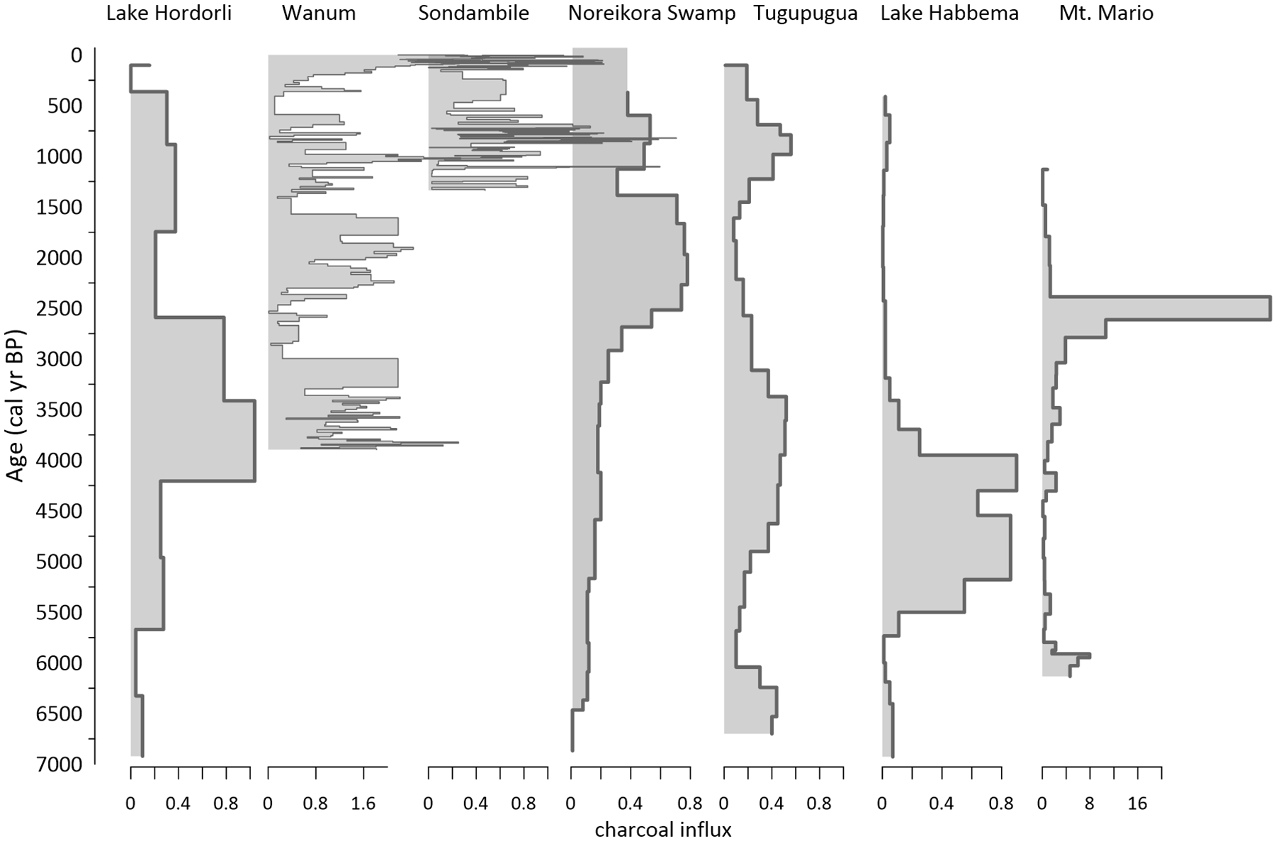
Charcoal results from Mt. Mario core 1 compared to charcoal records from other north New Guinea cores (see Figure 1 for locations). Data obtained from the Global Paleofire Database (paleofire.org).
Several records from highland contexts (Noreikora Swamp, Tugupugua, Lake Habbema) tend to display increases in charcoal influx during the Mid-Holocene with less pronounced variance during the later Holocene. In the dryer highlands, ENSO conditions probably play a more dominant role in driving burning, but heterogeneity in each record suggests that human activity may have influenced the resulting charcoal signal (Haberle and David, 2004). Notably, the Mt. Mario record partially diverges from many other fire records for New Guinea, particularly in that it lacks high rates of charcoal influx during much of the Mid-Holocene (excepting the peak at the very base of the core), however, the pronounced peak present beginning ~2600 cal BP is consistent with the composite fire record for the island as well as the Swallow Lake precipitation record. Unfortunately, we lack data for the last 1400 years that would allow us to situate patterning in the Mt. Mario core within the overall pattern of ENSO and rainfall variability during this time, particularly the LIA and last several centuries of increased ENSO activity. As such, the Mt. Mario record could be driven more by natural rainfall variance than by changes in human activity, however, given the overall high level of precipitation in the Aitape area (~2500 mm/year at present), we find it more likely that a combination of changes in rainfall and human forest management account for observed changes in fire history. Roos et al. (2023) have recently argued for a similar combined signal in Fijian charcoal records, where burning correlated with ENSO variability is substantially amplified after first human settlement. The development of savannah in the Port Moresby area of southern lowland New Guinea may likewise reflect combined effects of rainfall fluctuations and horticultural clearance (Rowe et al. 2020).
Throughout Core 1, charcoal is dominated by dark and blocky morphotypes that are likely of arboreal origin, with porous, cellular, and fibrous morphotypes present in decreasing frequency (see Supplemental Figure S4). While we are unable to make statements as to forest composition at the time of burning (i.e. whether representative of primary forest dominated by Nothofagus, or modified by humans to include substantial representation of economic tree crops), it is notable that both before and after the period of maximum fire activity at 2600 cal BC, significant increases in fibrous charcoal (likely derived from grasses) were detected suggesting that this increase in charcoal influx was likely associated with the opening of substantial cleared areas. The correlation of charcoal influx with elevated (Fe + Ti)/K and Mn/Fe ratios (also evident in Cores 2 and 3) plausibly relates to resulting increased erosion along the slopes of Mt. Mario.
Given the lack of fallow burning in the region today, periods of elevated fire activity in conjunction with forest clearing are noteworthy and hint at significantly different strategies of landscape management and food production during the interval from ~3000 to 2600 cal BP. Elsewhere on the island, shorter fallow periods are associated with burning as a means of more quickly restoring soil nutrients and typically correlate with areas of higher population density (Allen, 2005) As noted, root horticulture is today a relatively minor component of subsistence in the Aitape area, and when practiced, relies on little burning and relatively long fallow periods. Periods of elevated burning could therefore reflect shifts in horticultural production toward more substantial clearing, shorter fallowing, and more frequent burning. Horticultural intensity is not necessarily specifically linked to environmental potential in the New Guinea lowlands, and the ethnographic record documents both regional shifts in practices as well as the coexistence in relatively small areas of highly divergent subsistence practices (Allen, 2005). While arboriculture has been interpreted as a relatively stable and ancient mode of subsistence in the region (Latinis, 2000), our data suggest that in the Aitape area, forest management practices may have changed substantially at times in the past. Further analysis will be required to understand why this may have occurred, but a number of possible factors may be at play. This includes possible elevated population levels resulting from access to Mid-Holocene lagoonal resources, which may have proved difficult to maintain as lagoons infilled and the climate grew more arid. Alternatively (although not mutually exclusively), new cultivars could have been experimented with and ultimately found unsuitable for long-term exploitation. For instance, D. esculenta yams are believed to have been introduced to New Guinea around 3500–3000 years ago and replaced indigenous yam species as the primary food variety grown (Bourke and Allen, 2009). They form a principal crop in other areas of the northern lowlands but are not currently heavily relied upon near Aitape. We have recently initiated a pilot study of the Mt. Mario cores using chemical biomarkers as a means of reconstructing environment and forest composition which may provide direct evidence for changes in biota in the Aitape area and help to resolve the principal drivers of increases in charcoal input.
Conclusion
Coring work near Aitape, northern Papua New Guinea demonstrates the presence of a Mid-Holocene lagoon some 4 km south of the present coastline, and maps the development of modern coastal morphology from ~6600 to 1400 years ago, when the present coastal flats appear to have stabilized as sea levels retreated after the Mid-Holocene marine high stand. Combined with our earlier work some 40 km further east at Paniri Creek, this work provides empirical support for the development of productive coastal ecologies along the New Guinea north coast that may have facilitated population growth and increasing interconnectivity of coastal communities. However, our work also demonstrates the extreme dynamism of the north coast during much of the Holocene, making clear the challenges of locating archeology dating to before 1400 cal BP, which is likely to be deeply buried under more recent sediments. Analysis of charcoal in one of the sampled cores indicates increases in charcoal influx at ~6200–6000 cal BP and particularly from ~3000 to 2600 cal BP that in conjunction with other proxy indicators, suggests intensified land clearance. Poor pollen preservation hinders our ability to interpret the primary driver of increases in fire activity, however, comparison to regional charcoal records as well as rainfall/ENSO patterning suggests an interplay between subsistence practices and rainfall that have likely generated the composite fire record. Given that modern subsistence practices in the area do not rely on substantial burning of cleared fields, we suggest that increases in charcoal input might reflect increases in population associated with increasing horticultural intensity including shorter fallowing and more burning to restore soil fertility during the onset of the later Holocene.
Supplemental Material
sj-docx-1-hol-10.1177_09596836241274989 – Supplemental material for Waking the “sleeping giant?” Mid- to Late-Holocene environment and fire history in the Aitape area, northern Papua New Guinea
Supplemental material, sj-docx-1-hol-10.1177_09596836241274989 for Waking the “sleeping giant?” Mid- to Late-Holocene environment and fire history in the Aitape area, northern Papua New Guinea by Mark Golitko, Mitchell J Power, Jason Kariwiga and Kenneth Miamba in The Holocene
Supplemental Material
sj-xlsx-2-hol-10.1177_09596836241274989 – Supplemental material for Waking the “sleeping giant?” Mid- to Late-Holocene environment and fire history in the Aitape area, northern Papua New Guinea
Supplemental material, sj-xlsx-2-hol-10.1177_09596836241274989 for Waking the “sleeping giant?” Mid- to Late-Holocene environment and fire history in the Aitape area, northern Papua New Guinea by Mark Golitko, Mitchell J Power, Jason Kariwiga and Kenneth Miamba in The Holocene
Footnotes
Acknowledgements
All work was conducted in collaboration with the Papua New Guinea National Museum and Art Gallery with permission from the Papua New Guinea National Research Institute, Sandaun provincial government, Aitape-Lumi regional administration, and Aitape Diocese. This research was greatly assisted by Herman Mandui, Alois Kuaso, Michael Watae, Otto Separy, Andrew Moutu, Ethan Cochrane, James Goff, Shaun Williams, Thomas Winter, Alyssa McGrath, Jack Drey, Clay Jaskowski, Elliot Wong, Georgia Kaipu, Jim Robins, Matthew Leavesley, Walter E. North, Joe Mangi, Nick Araho, John Ainap, Hillary Suamba, John Sairi, Paul Saike Tamas, Casper Foingi, Raphael Seki, John Akove, Denis Wena, Job Mango, Wilson Miroi and Awareh Ltd., and the numerous other people of the Aitape area who generously offered their time and help. We offer particular thanks to Henrik Afalaki for his invaluable help in the field.
Funding
The author(s) disclosed receipt of the following financial support for the research, authorship, and/or publication of this article: This work was supported by the United States National Science Foundation [grant number BCS1155338]; The Field Museum Regenstein Fund for Pacific Research; The University of Notre Dame.
Supplemental material
Supplemental material for this article is available online.
References
Supplementary Material
Please find the following supplemental material available below.
For Open Access articles published under a Creative Commons License, all supplemental material carries the same license as the article it is associated with.
For non-Open Access articles published, all supplemental material carries a non-exclusive license, and permission requests for re-use of supplemental material or any part of supplemental material shall be sent directly to the copyright owner as specified in the copyright notice associated with the article.