
Abstract
We present an archaeobotanical record representing ~2300 years BP farming practice at Nagardhan an Early Historic—Late Medieval site in the Vidarbha region, Maharashtra, central India. The study assesses the crop harvesting patterns and Indian Summer Monsoon (ISM) intensity using two different approaches (archaeobotany, and canonical correspondence analysis) to understand the variability and impact of ISM on human subsistence systems during periods of dynastic transition. Our results show a gradual transformation from a warm-humid climate during the Early Historic and Historic (300 BCE–1200 CE) with the dominance of large-grained cereals (C3 plants); to dry climate during the Medieval and Early Modern periods (1200–1900 CE) due to weakening of southwest monsoon (SWM) as evidenced by the dominance of small-grained millets (C4 plants). The changing crop assemblage and cultural developments in this area of central India provide insights into past human responses to climate change and provide insights for modern societies in exploring sustainable agricultural policies during the ongoing climate deterioration. Moreover, the present study provides insights into the Indian Summer Monsoon (ISM) rainfall variability during the Late-Holocene in global climate change perspectives from one of the poorly understood areas of the tropics in Southeast Asia where the rainfall is essentially controlled by the ISM.
Introduction
The Indian Summer Monsoon (ISM) is a synoptic weather system that strongly influences and helps to shape socio-economic and cultural development and transformation across South Asia, and today India’s agricultural output, economy and societal well-being are dependent upon the stability of the southwest summer monsoon, its variability and extremes. Deviations in ISM precipitation can severely impact the agricultural productivity and Gross Domestic Product (GDP) of the country (Cook et al., 2010; Gadgil, 2003, 2018; Gadgil and Gadgil, 2006; Quamar, 2019; Quamar et al., 2024; Quamar and Bera, 2020 and references therein). Consequently, understanding the spatio-temporal dynamics of the ISM precipitation throughout the Holocene is important to contextualizing and understanding cultural and economic development and the establishment and abandonment of urban settlements and agricultural intensification (Chauhan and Quamar, 2010; Mayewski et al., 2004; Quamar, 2022; Quamar et al., 2021, 2024). Here we explore the role of ISM variability on long-term agricultural strategies in Central India, through the presentation of carbonized crop remains from the site of Nagardhan, in a region lacking in comprehensive archaeobotanical studies, especially those from the Early Historic and Late Historic periods.
Archaeobotany in India is well established as a valuable scientific tool and has been widely used to investigate continuity and change in past agricultural economies, subsistence strategies, and environments (Goyal et al., 2013; Pokharia et al., 2011, 2014, 2017, 2020, 2024). The social and economic changes in South Asia have been linked to climate variability to provide context for understanding population resilience that has been sustained by agricultural strategies, such as selective seasonal cultivation or crop diversification (Pokharia et al., 2014, 2017, 2020, 2024; Thakur et al., 2019). Changing levels of precipitation also have significant impacts on water resources, agricultural production and, consequently, the economy (Gadgil and Gadgil, 2006; Webster et al., 1998).
Vidarbha (Lat. 18.849660°N–21.552027°N and Long. 75.993740°E–80.385398°E), the north-eastern region of Maharashtra, encompasses most of the central region of India and is considered one of the most prosperous regions of Maharashtra despite some of the highest monsoon variability (Nath, 1992). The Satavahana dynasty was the first empire builder of Maharashtra in the late 2nd Century BCE to early 3rd Century CE. The Satavahana are believed to have succeeded the Mauryans in the Deccan and central India. The study site Nagardhan served as the capital of the kingdom of Vakataka, the successors of the Satavahana, the dominant power in central India from the mid-3rd to the late 5th century CE (Mirashi, 1963; Shastri, 1997). Consequently, the study presented here, stretching from the Early Historic through to late historic period is of significance, providing insight into the regional agricultural dynamics between ~400 BCE and 1900 CE.
Several proxies have been used to determine the ISM variability in central India during the Late Holocene (Anderson et al., 2010; Anoop et al., 2013; Enzel et al., 1999; Ponton et al., 2012; Prasad and Enzel, 2006; Sarkar et al., 2016). Quamar et al. (2021), which suggest a warm-humid climate and intensification of the ISM during the period ~650 BCE–150 CE in central India. These warm and humid conditions, coupled with strong rainfall, were associated with the rise of the Roman Empire (Roman Warm Period—RWP) in Europe. Similarly, in India, the RWP coincided with the rise of the Mauryan Empire (Singh, 2008). The economic peak, driven by agricultural expansion and intensification, along with trade surpluses, during the RWP led to this period being labeled the “Golden Age of India” (e.g. McCrindle, 1877; Singh et al., 2020). Sinha et al. (2007, 2011) proposed an intensified ISM during the Medieval Warm Period (MWP) between ~920 and 1350 CE. Chauhan and Quamar (2010) suggested a warm and moist climate with an active southwest monsoon between ~400 and 1300 CE, supporting tropical deciduous Sal (Shorea robusta) forests around the landscape of the Shahdol District (Madhya Pradesh), central India. In the global context, this monsoonal climate corresponds with the MWP, recorded between around 750–1200 CE (Anderson et al., 2002; Lamb, 1977). Quamar and Chauhan (2014, proposed a warm and moderately humid climate that sustained open mixed vegetation around the landscape of the Betul District, Madhya Pradesh, central India between ~530 and 1200 CE), corresponding with the MWP. Similarly, between ~750 and 1400 CE, dense mixed tropical deciduous forests were suggested in the Chhattisgarh region of central India, under a warm and humid climate with increased monsoon rainfall (Quamar and Bera, 2021). Sinha et al. (2007, 2011) suggested a weakened ISM between ~1350 and 1510 CE, based on the δ18O analysis of speleothems collected from Dandak and Jhumar caves in central India. Chauhan and Quamar (2010) proposed a comparatively drier climate (due to a weak southwest monsoon) supporting mixed tropical deciduous forests around the landscape between ~1250–1650 CE in Madhya Pradesh, central India. This period of harsh monsoonal climate partially falls within the temporal range of the Little Ice Age (LIA), globally recorded between 1450 and 1850 CE (Bradley, 1985). The weak monsoon during the LIA may be associated with intensified Westerlies over northwest India due to the Asian westerly jet stream intensification over the Middle East during a positive phase of the North Atlantic Oscillation (NAO) and the migration of the Asian jet to lower latitudes during the warm phase of the El Niño-Southern Oscillation (ENSO; Dixit and Tandon, 2016). The sharp reduction in rainfall has been linked to episodes of economic and societal collapse, increases in inter-polity conflict, internal competition for resources, and socio-economic upheavals (Gupta et al., 2019).
Geology, modern climate, and vegetation of the Vidarbha
The surface geology of Maharashtra state is largely composed of igneous rock or trap basalt formed from molten magma known as Deccan traps, spanning all parts of Maharashtra except the eastern districts of Vidarbha region and Sindhudurg and Ratnagiri districts (Dikshit, 1986). The region of Vidarbha is drained by the Wardha, Wainganga, Penganga and Purna rivers. Another river that drains the Vidarbha region is Kanhan, a tributary of the Godavari River. Most of the soils at Vidarbha are occupied by dark shaded alluvial/laterite referred to as black cotton soils.
The Vidarbha region is characterized by a hot summer and general aridity year-round except during the southwest monsoon season that is, from June to September. In summer, the mean and maximum temperature is 27.5°C and 45°C respectively and in the winter the temperature ranges between 12°C and 14°C. The average rainfall in this region is 700 mm. The unequal topographical condition and the absence of a prominent rivers, the agriculture of the area is rain-fed. Mere variations in the precipitation distribution may affect the agrarian livelihood of the area (Nair and Mirajkar, 2021). According to Koppen’s climate classification the study region experiences tropical savannah-type climate (Aw), and Mesothermal climate-Gangetic Plain-type (Cwg) climates (Köppen, 1936; Quamar and Kar, 2020). However, according to Köppen-Geiger System of climate classification (Beck et al., 2018), Vidarbha region of Maharashtra (Central India) experiences Tropical Savannah (Aw), Arid, Steppe, hot (BSh), as well as Tropical Monsoon (Am) climates. Vegetation of the Vidarbha region is roughly divided into evergreen, deciduous and thorny scrub forests, allowing for the availability of plant resources in this region at any time of the year. According to Champion and Seth (1968), tropical dry deciduous forests, tropical moist deciduous forests and tropical thorny/scrub forests occupy the landscape around the study area (Quamar and Kar, 2020). The important surrounding vegetation of Vidarbha region include tree taxa, such as Tectona grandis, Phoenix dactylifera, Bombax ceiba, Terminalia tomentosa, Terminalia elliptica, Terminalia catappa, Butea monosperma, Acacia catechu, and Acacia leucophloea. Additionally, Annona squamosa, Mangifera indica, Syzygium cuminii, and Limonia acidissima are also found. The main shrubby taxa found in the region are Calotropis procera, Lantana camara, Ricinus communis, Capparis zeylanica, Ziziphus mauritiana, Justicia adathoda and Dioscorea bulbifera. Additionally, Byttneria herbacea, Leucas longifolia, Vigna trilobata var. trilobata, Exacum petiolare, Ceiba pentandra, Persicaria barbata var. gracilis, Millettia peguensis, Cyanotis axillaris, Alysicarpus ovalifolius, and Justicia betonica are important herbaceous taxa growing in the region (Champion and Seth, 1968).
Crops in and around Vidarbha consist mainly of Oryza sativa (rice) in summer and Triticum aestivum (wheat), Hordeum vulgare (barley) in winter. Other major summer crops of the Vidarbha region are sorghum millet, pearl millet, pigeon pea, cotton, groundnut and sugarcane.
Archeology and stratigraphy of Nagardhan
The archeological site Nagardhan (Lat. 21.3370°N; Long. 79.3158°E) is situated in Vidarbha region near Nagpur, Maharashtra, India (Figure 1a). Nagardhan has been associated with Nandivardhan, the capital of Vakataka dynasty, which was ruled over 250–500 CE. The excavation at this site was carried out by the Directorate of Archeology and Museums, Maharashtra, and the Department of A.I.H.C. & Archeology, Deccan College, Pune in three seasons 2015–16, 2016–17, and 2017–18. The area around the Nagardhan fort is used for cultivation of crops in modern day. At the western end, Bhagi drain flows about 2.3 km which gets filled during the rainy season. Larger water channels are also seen on the north and east sides; hence, these streams were diverted around Nagardhan to form permanent water bodies in the Early Historic period.
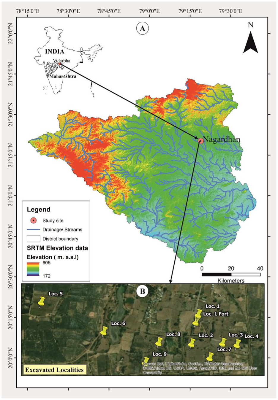
Map showing Vidarbha region, archeological site Nagardhan (A) and excavated localities (B).
The site is divided into nine different localities (Figure 1b). During the year 2015–17, trenches C, D1, and H (Figure 2A-D) in Locality 1; I, I1, and J in Locality 2; L, M (Figure 2E), in Locality 3; N, O, and XN in Locality 4 were excavated. A probable ritual area was found with full pots (trench N & XN) shown in (Figure 2F and G).
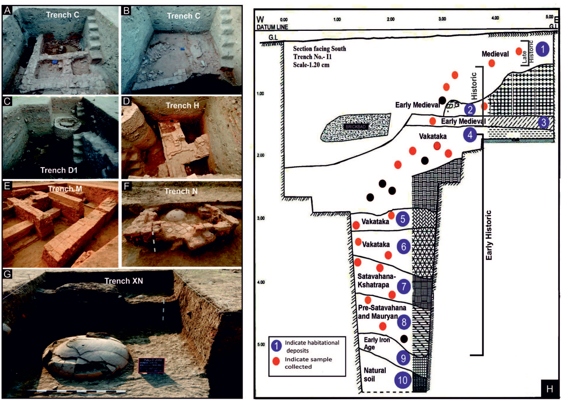
Excavated trenches C, D1, and H (A-D) in locality1, M (E) in locality 3, a probable ritual area with full pots (Trench N & XN) in locality 4 (F and G), section drawing showing cultural sequence in trench I (H)
During the year 2017–18, the excavations were resumed at the site of Nagardhan in continuation with previous two seasons. Two trenches (H2, HX) were laid in the Locality 1, trench V was laid at a distance of 75–80 m from the earlier excavated trenches I and J from in Locality 2, trenches EL and M in locality 3, O3 in locality 4, S2 and P in locality 9 were also excavated. All trenches were 10 m×10 m in dimension. They were further divided into four quadrants each of 5 m×5 m. The stratigraphy of trench H which gives a complete cultural sequence is shown in Figure 2h.
The nearest Climate Research Unit Timeseries (CRU TS) 4.08, 0.5 × 0.5 gridded climate data points, 1901–2023, showing the mean monthly precipitation and temperature around the site of investigation in Nagardhan, Vidarbha region (Maharashtra), Central India, and is shown in Figure 3 (Harris et al., 2020). The Mean Annual Precipitation (MAP) is 1137.061 mm and the Mean Annual Temperature (MAT) is 26.94ºC. The area receives most of its precipitation (~85%) during June to September (JJAS) from the ISM. Around 20% rainfall, however, takes place during October to December (OND) due to the Northeast Monsoon, and also during January to April (JFMA) owing to Western Disturbances (Benn and Owen, 1998; Gadgil, 2003).
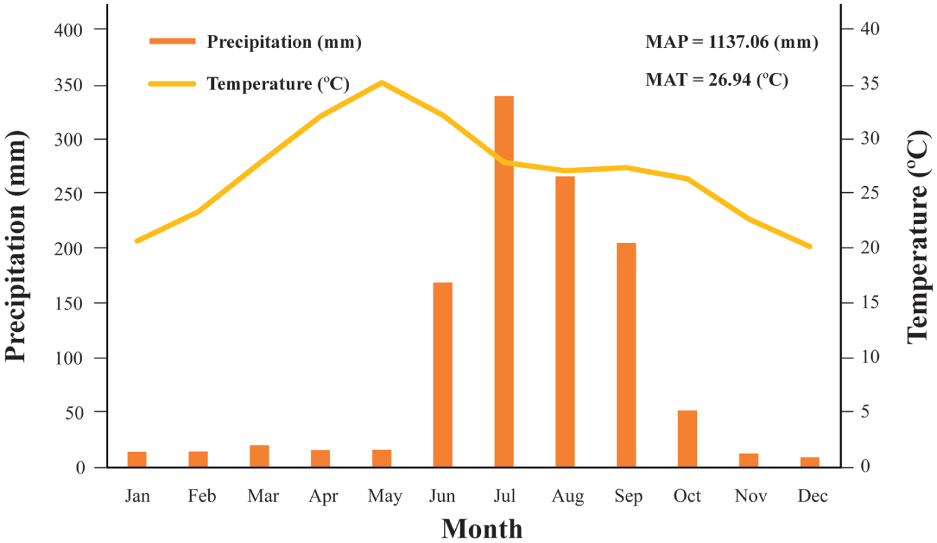
Nearest climate research unit time series (CRU TS) 4.07, 0.5 × 0.5 gridded climate data point, 1901–2023, showing mean monthly temperature and precipitation around the study area in Vidarbha region of Maharashtra State, Central India. MAP: mean annual precipitation; MAT: mean annual temperature.
Materials and methods
Macrobotanical remains: collection, sorting, and identification
Carbonized grains/seeds/fruits were recovered from stratified deposits, floor levels, pits, and hearth areas across almost all excavation areas through flotation (Pearsall, 2000). Buoyant material was collected in a 30 mesh (0.5 mm) geological sieve. In total 100 samples were collected from 4700 L of processed sediment during three excavation seasons (2015–18). Plant remains were sorted into morphological categories and photographed under a stereo-binocular microscope (Leica Z6APO; Figure 4). Identification was made in the laboratory using the BSIP institutional reference collection and published literature (Martin and Barkley, 1961; Pokharia, 2008; Pokharia et al., 2011, 2017, 2020).
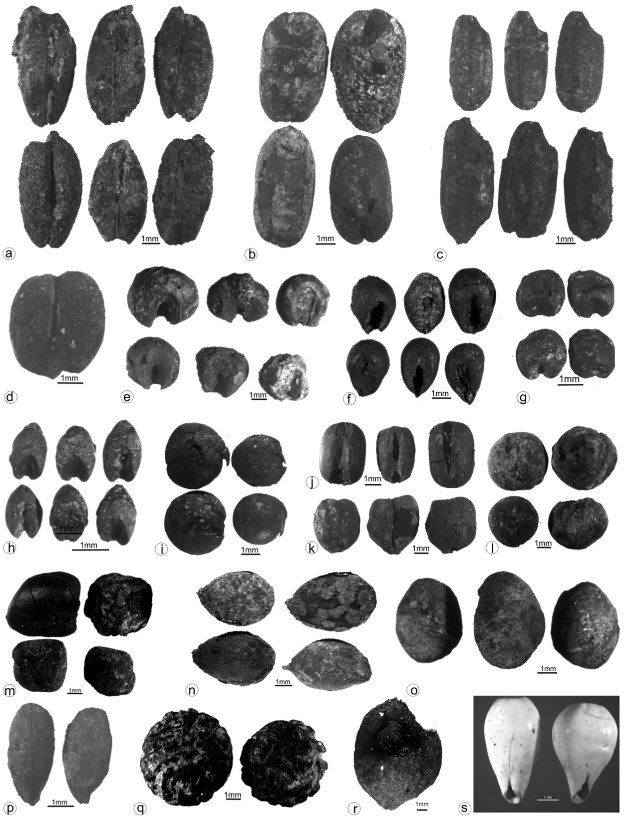
Selected botanical remains from Nagardhan archeological site: (a) Hordeum vulgare, (b) Triticum aestivum, (c) Oryza sativa, (d) Triticum sphaerococcum, (e) Sorghum bicolor, (f) Pennisetum glaucum, (g) Paspalum scrobiculatum, (h) Setaria sp., (i) Lens culinaris, (j) Vigna radiata, (k) Cicer arietinum, (l) Pisum arvense, (m) Lathyrus sativus, (n) Gossypium arboreum/herbaceum, (o) Lablab purpureus, (p) Linum usitatissimum, (q) Ziziphus sp., (r) Terminalia sp., (s) Coix lachryma-jobi.
Chronology
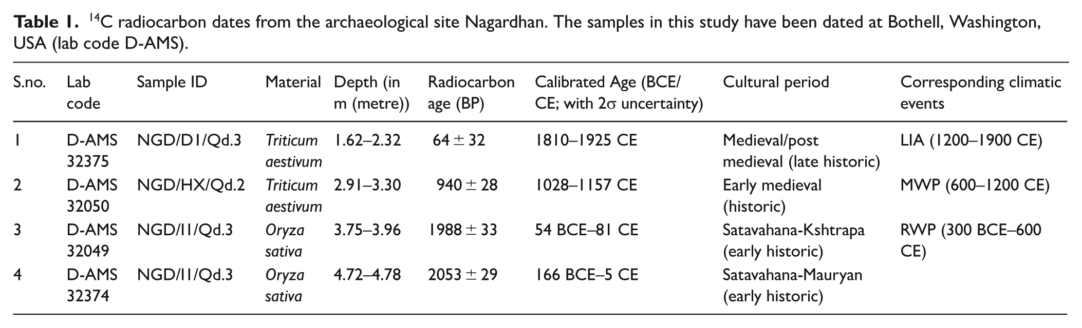
Four carbonized grains from different trenches and depths were dated from Direct AMS, USA (laboratory code D-AMS; Table 1). Radiocarbon determinations were calibrated using OxCal v4.4 and the IntCal20 calibration curve (Reimer et al., 2020; Supplemental Figure S1). As ceramics and other material culture from the region are well-seriated (Dhavalikar et al., 1988), these dates are primarily used to support these chronological assignations.
14C radiocarbon dates from the archaeological site Nagardhan. The samples in this study have been dated at Bothell, Washington, USA (lab code D-AMS).
Statistical approaches
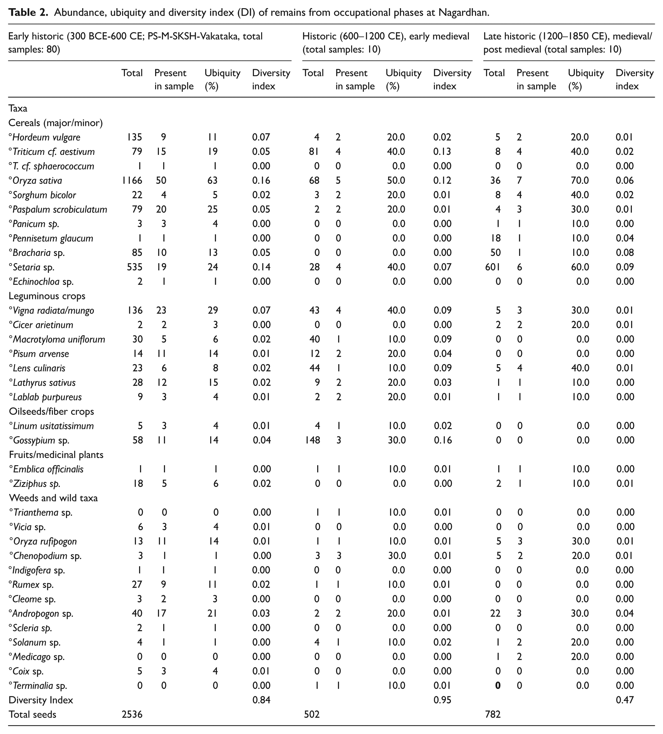
Absolute abundances of plant taxa, their relative abundance and ubiquity in each archeological period (Minnis, 1981; Popper, 1988), and Shannon–Weaver index (Clarke and Warwick, 2001; Pearsall, 2000) or diversity index (DI) were used to quantify and analyze the assemblage (Table 2). Ubiquity is the percentage of samples from which a specific taxon or plant was recovered and DI (Shannon Weaver index) summarizes data to describe the composition of a sample population. DI was calculated using the following formula. DI = ∑(NX/NT) log (NX/NT), where NX is the number of seeds of a specific species “X” in the phase and NT is the total number of seeds “T” in the phase.
Abundance, ubiquity and diversity index (DI) of remains from occupational phases at Nagardhan.
Relationships between the DIs and the ISM rainfall were sought using Pearson’s correlation coefficients. There is no high resolution palaeo-ISM proxy data available for that region except a weighted average paleoclimatic index (WApCI) that was synthesized statistically from the Central Indian Core Monsoon Zone (CMZ) specific publications based on the pollen data (Ali et al., 2019). The resolution of the synthesized data is 100 years. We validated the WApCI data using unevenly spaced δ13C data from Central Himalaya, Benital Lake (Ghosh et al., 2020) after interpolating the WApCI and δ13C values to our measured ages.
Canonical correspondence analysis (CCA) where the most important components in the multivariate dependent (biotic, abundance of seeds and DI) data are constrained by the independent abiotic (climate parameters) data was carried out in R (R Core Team, 2021). On the basis of linear combination of abundance of crop taxa from three different time periods that is, Early Historic (300–600 CE), Historic (600–1200 CE) and Late Historic (1200–1900 CE), CA extracted independent components hidden in the samples from these time periods including the abundance and diversity indices of major cereals, minor cereals, pulses, oilseed/medicinal and fruits, and these components were constrained (or explained) using the variability of rainfall indicators (WApCI/PDF and δ13C) during time periods that we studied. The abbreviations/codes for plant taxa used in statistical analyses are given in Supplemental Table 1.
Results
Chronology at Nagardhan
The excavations at Nagardhan identified several clear cultural phases—Early Iron Age (800–300 BCE); Mauryan-Pre-Satavahana (300–150 BCE), Satavahana-Kshatrapa (150 BCE–250 CE), Vakataka (250–600 CE), together comprising the Early Historic; the Early Medieval (600–1200 CE) which forms the Historic period; and a Late Medieval or Late Historic period (1200–1900 CE). These cultural phases were delineated based on artifactual finds such as ceramics (including red polished ware, kaolin ware, red slipped ware of the Satavahana-Kshatrapa period and mica wash/slipped red ware of the Vakatakas) in various forms and designs; beads made from semi-precious stones (such as carnelian, lapis lazuli, jasper, and agate); glass bracelets; stone tiles with deer depiction and ivory knives. These finds correlate well with the age ranges of grains dated at the site (Table 1). Here we group the Mauryan-Pre-Satavahana, Satavahana-Kshatrapa, and Vakataka as the Early Historic Period; the Early Medieval as the Historic period; and the Late Historic period comprises the Medieval Phase/post-Medieval. Archaeobotanical remains from these Periods were studied to understand the agricultural pattern during dynastic periods and the impact of global climatic events (RWP, MWP and LIA) in Central India.
Macrobotanical remains
The macrobotanical remains recovered and identified from Nagardhan were obtained from 100 out of 103 samples collected from 4900 liters of sediment. In total 3820 carbonized remains were recorded and identified as cereals, leguminous crops (major/minor), oilseeds and fiber crop, fruits/medicinal plants, weeds and wild taxa (Figure 4, Table 2).
During the Early Historic Period (300 BCE–600 CE) cereals are represented by Oryza sativa (48%), Hordeum vulgare (6%), Triticum aestivum (3%), Triticum cf. sphaerococcum (>1%) followed by, minor cereals (millets)-Sorghum bicolor (1%), Paspalum scrobiculatum (3%), Bracharia sp. (3%), Setaria sp. (22%), Pennisetum glaucum (>1%), Panicum sp. (>1%), Echinochloa sp. (>1%). Leguminous crops are represented by Vigna radiata/mungo (6%), Pisum arvense (1%), Lens culinaris (1%), Lathyrus sativus (1%), Macrotyloma uniflorum (1%), and Lablab purpureus (1%). Oil and fiber yielding crops are represented by Linum (>1%) and Gossypium arboreum/herbaceum (2%). The fruit remains are represented by Emblica officinalis (>1%) and Ziziphus sp. (1%; Supplemental Figure S2), along with number of weeds and wild taxa. The archaeobotanical evidence indicate a well-developed agricultural system based on winter and summers crops. The dominance of C3 plants (70%) indicates effective moisture during the period, corresponding with Roman Warm Period (RWP). The abundance of rice at the site is further supported by evidence from Bhagimohari, Naikund and Rithi Ranjana (Kajale, 1981, 1991; Patel et al., 2021). Rice the primary crop, accounted for 48% of the total winter and summer crop assemblage.
Plant remains from the Historic Period (600–1200 CE) comprise Oryza sativa (14%), Triticum aestivum (17%), Hordeum vulgare (1%), Setaria sp. (6%), Sorghum bicolor (1%), Paspalum scrobiculatum (>1%) among major and minor cereals. Besides, leguminous crops– Vigna radiata/mungo (9%), Lens culinaris (9%), Macrotyloma uniflorum (8%), Lathyrus sativus (2%), Pisum arvense (2%), and Lablab purpures (>1%) and the oil/fiber crops– Gossypium arboreum/herbaceum (30%) and Linum usitatissimum (1%) were also reported as field crops (Supplemental Figure S2). The C-3 plants (cereals, legumes and oil/fiber crops) dominate the assemblage (92%) in comparison to C4plants (8%). Diversification and evenly distributed plant species have been observed during this period (DI = 0.95 almost close to 1). Winter crops comprise for 32% of the assemblage, and summer crops accounts for 68%. Wheat and Rice are the numerically dominant cereals. This period corresponds to a warmer and more humid climate associated with the Medieval Warm Period (MWP).
The plant assemblage from Late Historic Period (1200–1900 CE) indicates decline in diversity (DI = 0.47). The cereals (major/minor) are represented by Hordeum vulgare (1%), Triticum aestivum (1%), Oryza sativa (5%), Setaria sp. (80%), Bracharia sp. (7%), Pennisetum glaucum (2%), Sorghum bicolor (1%), Paspalum scrobiculatum (1%) and Panicum (>1%); leguminous crops- Vigna radiata/mungo (1%), Lens culinaris (1%), Cicer arietinum (>1%), Lathyrus sativus (>1%), and Lablab purpureus (>1%; Supplemental Figure S2). C3 plants accounts for 10%, whereas C4 (millets) accounts for 90% in this phase, this phase corresponds to drier climate—known as Little Ice Age (LIA) a global event. These C4 plants (small-grained millets) are drought-resistant crops, showing shift in the dependence on existing species, suggesting a warmer or drier climate, as southwest monsoonal (SWM) activity might have decreased considerably during this phase. Adverse climatic conditions due to declining monsoon might have provided suitable conditions for these crops in Vidarbha region.
The WApCI and δ13C values were interpolated for the age values for which the diversity indices were calculated. The palaeo-ISM index (WApCI) was validated by a negative correlation coefficient (r = − 0.94, p-value = 0.23) observed between WApCI and δ13C (Kohn, 2010; Figure 4). A negative correlation is expected between these two because more depleted stable carbon composition (δ13C) is an indicator of more water availability and thus a good rainfall (WApCI/PDF). The cereals’ diversity index was positively correlated (r = 0.91, p-value = 0.27) to the ISM rainfall, and a similar positive correlation, but insignificant, were observed between ISM and pulses (r = 0.36, p-value = 0.76) and fruits (r = 0.56, p-value = 0.62) as well. There is an overall positive correlation of diversity indices of cereals, pulses and fruits with ISM rainfall within 3 ka. These correlation values are apparently insignificant and the limited number of species/taxa might be the reason (cereals = 10, pulses = 7, and fiber = 2). A consistent, positive Pearson correlation coefficient values between the diversity indices and ISM rainfall suggest climate, particularly rainfall, drove agricultural variability.
Canonical correspondence analysis (CCA)
The two CA components accounted 54.9% and 45.1% of the data variability. As there were only two explanatory variables, each of CA component can be identified with each explanatory variable. Further, as these two explanatory variables were correlated to each other (anti-correlated; Figure 5; nearly 180° between PDF and δ13C in Figure 6), essentially only one explanatory variable is used in this study, and for convenience’s sake we consider PDF (WApCI, ISM rainfall indicator) as the explanatory variable. The biplot (Figure 6) shows δ13C and PDF (blue lines) spread the samples from three different time periods along the first axis of CCA. It is clear the ISM rainfall has shown to be increasing from LIA to MWP via RWP (Figure 6).
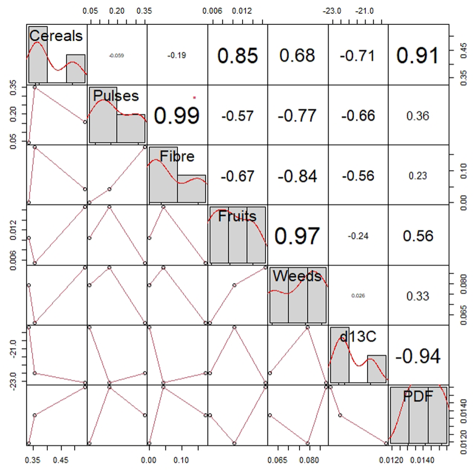
The Pearson’s correlation coefficient of PDF (the ISM proxy and WApCI) and δ13C with the response variables (cereals, pulses, oilseeds, fruits and weeds) are given. The red stars above the value in the upper matrix indicate the significance of the coefficients. One start mean p-value is 1/10.
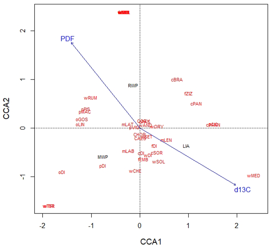
The CCA triplot showing the position of different time periods (black color) in the ordination diagram characterized by the abundance of cereals, pulses, oilseeds, fruits and weeds with their own diversity indices (red color). The blue lines indicate the vector of explanatory variables (PDF/WApCI and δ 13C).
Discussion
The extension of Harappan culture from north-western India to the Pravara valley in Maharashtra around 2000 BCE may have laid the foundations for early agriculture in central India (Kajale, 1991; Saraswat, 1992), with evidence of copper and molluscan shells from the Chalcolithic sites of Daimabad and Inamgaon (2000–1600 BCE) in Maharashtra suggesting that they obtained copper from south-eastern Rajasthan and molluscan shells from Saurashtra through trade networks (Dhavalikar, 1984). Archaeobotanical studies show clear evidence of both summer and winter crops at both sites, with the field crops from Inamgaon and Daimabad including wheat (Triticum aestivum and T. sphaerococcum), barley (Hordeum vulgare), finger millet (Eleusine coracana), lentil (Lens culinaris), field-pea (Pisum arvense), grass-pea (Lathyrus sativus), horse-gram (Macrotyloma uniflorum), cow-pea (Vigna unguiculata), hyacinth bean (Lablab purpureus) and black-gram (Vigna mungo; Kajale, 1977a, 1977b). Further, excavations at Apegaon and Tuljapur Garhi (1600–1200 BCE) in Maharashtra provide evidence of the continued cultivation of wheat, barley, rice, jowar-millet, kodo-millet, ragi-millet, foxtail-millet, green-gram, black-gram, lentil, grass-pea, field-pea, pigeon-pea, chick-pea, horse-gram, hyacinth bean, safflower and linseed (Kajale, 1976-77, 1988; Table 3).
Field-crops recorded from archeological sites in Vidarbha and adjoining region.
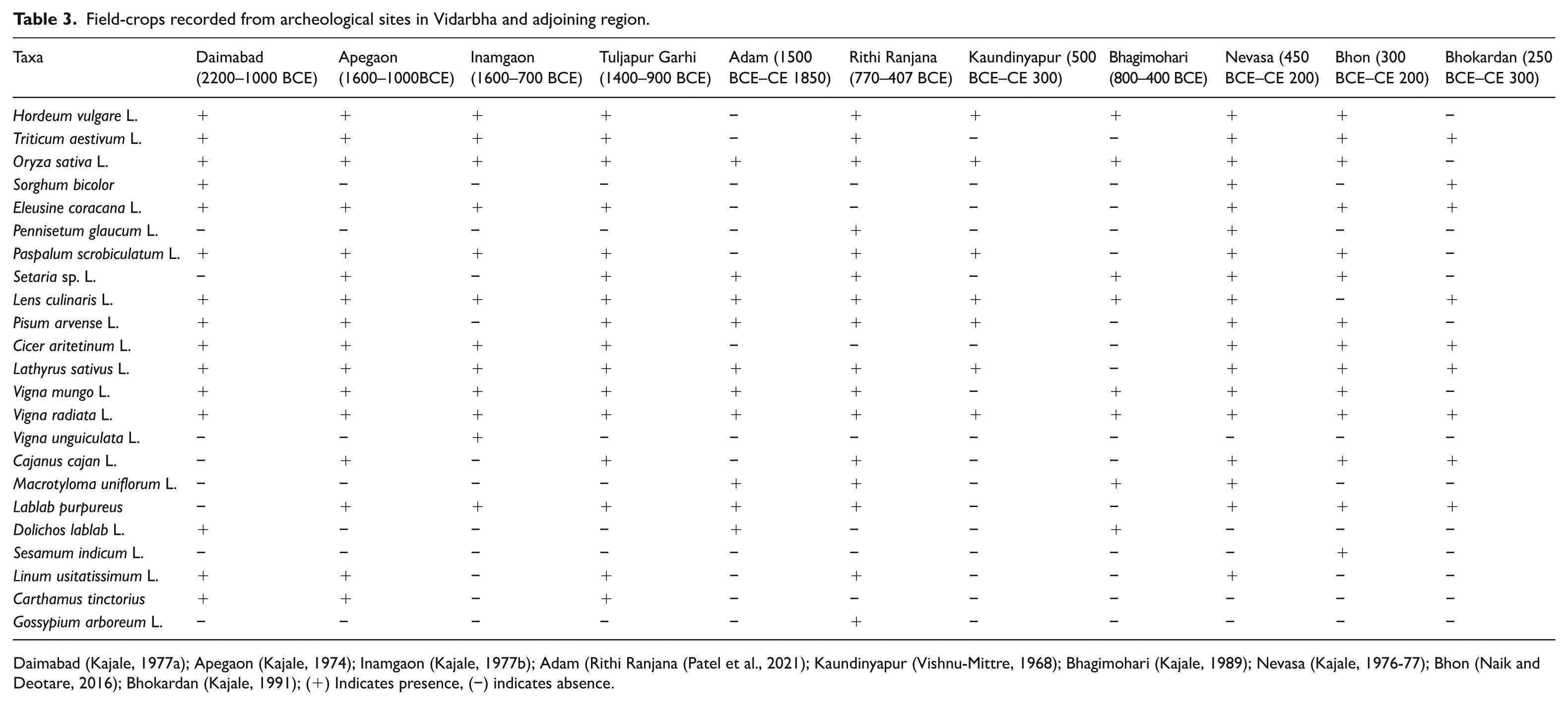
Daimabad (Kajale, 1977a); Apegaon (Kajale, 1974); Inamgaon (Kajale, 1977b); Adam (Rithi Ranjana (Patel et al., 2021); Kaundinyapur (Vishnu-Mittre, 1968); Bhagimohari (Kajale, 1989); Nevasa (Kajale, 1976-77); Bhon (Naik and Deotare, 2016); Bhokardan (Kajale, 1991); (+) Indicates presence, (−) indicates absence.
The succeeding Jorwe Culture (ca. 1300–900 BCE) in Maharashtra has shown the settlement patterns, socio-political organization, technology, religious beliefs and exchange networks better than other Chalcolithic cultures in the Deccan and central India (Dhavalikar, 1984). Lime-making was a flourishing industry of Jorwe communities, as testified by Inamgaon evidence (Dhavalikar, 1984). During the Jorwe times, cotton was spun in Maharashtra and flax was also used. This inference is based upon the discovery of beads strung upon a thread of silk with a cotton nep from Nevasa in Ahmednagar district and the discovery of a second such string of beads at the site of Chandoli in Pune district, which had a thread of flax (Clutton-Brock et al., 1961).
During the early Iron Age (1000–700 BCE) a mixed or double cropping suggest the continued agricultural practices from the preceding cultural phases (Patel et al., 2021). The site of Nagardhan and its adjoining areas consist of alluvial deposits, providing excellent conditions for agricultural production, supported by our archaeobotanical data from and other records from “rural” archeological sites in the region (Table 3). The north-western Deccan region became the transitional zone of North Indian (Indus Valley and Indo-Gangetic plains) and South Indian agriculture, a point where distinct and different cultures and agricultural traditions met as they spread throughout the Indian subcontinent. The population at Nagardhan mainly subsisted on the starch and protein rich crops, such as Oryza sativa, Triticum aestivum, T. spherococcum, Hordeum vulgare, Sorghum bicolor, Pennisetum glaucum, Paspalum scrobiculatum, Panicum sp., Bracharia sp., Setaria cf. italica, Echinochloa sp., Pisum arvense, Lens culinaris, Cicer arietinum, Lathyrus sativus, Vigna radiata, Vigna mungo, Macrotyloma uniflorum. Additionally, oil and fiber yielding crops also played important roles in the subsistence economy.
Crop-continuity and shift: indication for adaptation and resilience in central India
The second (or post-Harappan) urbanization in central India began around 600 BCE (Deotare, 2006), reaching a peak, driven by agricultural expansion and trade surplus, during the Mauryan Empire resulting in this period often being referred to as the “Golden Age of India” (e.g. McCrindle, 1877; Singh et al., 2020). As a matter of fact, the increased ISM, which is contemporaneous with an increased solar insolation and associated northward shift of the Inter Tropical Convergence Zone (ITCZ; Haug et al., 2001; Solanki et al., 2004), made the way for the growth of an agricultural-based economy and societal well-being (McCormick et al., 2012). Pokharia et al. (2024) suggested that winter crops were dominated by summer crops in the total plant assemblage (TPA) during the RWP (200 BCE–500 CE) in Vadnagar, Gujarat. Large-grained cereal (e.g. rice) account for 95% compared to the small-grained cereals (e.g. millets), which had only 5% in the TPA owing to the increase in the ISM rainfall. In India, the RWP coincides with the rise of Maurya Empire (Singh, 2008). The agricultural production boosted as a result of increased ISM strength, bringing socioeconomic prosperity in this densely populated region of the globe (Gupta et al., 2006; Singh, 2008). Major centers of trade, industry and commerce were developed in the Indian subcontinent and trade expanded with the Europe, Mesopotamia, Egypt and western countries as far as the African coast, resulting into the welfare of the society. During the subsequent Satavahana dynasty in the Deccan (200 BCE–400 CE), land and sea trade routes were well developed, playing a great role in the exchange of ideas and culture between the northern Indo-Gangetic Plain and South India (Dhavalikar, 1995; Warmington, 1974). The archaeobotanical evidence during the Early Historic period (300 BCE–600 CE) surmise that a well-developed agricultural system based on winter and summers crops was in practice. Among the cereals rice was dominant (48%), the abundance of rice in the region is further supported from Bhon (Pre-Satavahana and Satavahana period), Bhokardan (Satavahana), Ter (Late Satavahana), Nevasa (Satavahana and Indo-Roman), Multicultural sites viz Adam, Kaundinyapur, Bhagimohari, Naikund and Rithi Ranjana (Kajale, 1976-77; Naik and Deotare, 2016; Patel et al., 2021; Vishnu-Mittre, 1968, 1991). These results are comparable with published data from other localities that comprise rice and mung bean almost exclusively during the same time period (Pokharia et al., 2021).
The cultivated crops during the Historic Period (600–1200 CE) indicate continuity with the preceding phase. The cereals, legumes and oil/fiber crops accounted for 92% in comparison to millets (8%). Wheat and Rice are the numerically dominant cereals. This period corresponds to warm and humid climate event-Medieval Warm Period (MWP) whose hydrological condition was better than in RWP (Figure 5). Pokharia et al. (2024) suggested that owing to the intensified ISM during the MWP (500–1300 CE), large-grained cereal account for 85%, whereas small-grained millets account for 15% in the TPA in Vadnagar, Gujarat.
The post-Gupta (5th–9th century CE) site Paturda in Buldhana District also revealed abundance of rice (50%) and marginal recovery of millets (Deotare, 2006). High proportion of rice grains, as well as rice husk (about 50%), were recorded from Bhon site (Naik and Deotare, 2016).
The plant assemblage from Late Historic Period (1200–1900 CE) indicates decline in diversity (DI = 0.47). Large-grained cereals, pulses and oil-seeds accounts for 10%, whereas small-grained millets accounts for 90% in this phase, this phase correspond to drier climate –known as Little Ice Age (LIA), whose hydrological condition was worse than in RWP (Figure 6). These small-grained millets are hardy, and drought-resistant, showing shift in the cropping pattern due to declining monsoon in Vidarbha region during this time bracket. This change in cropping strategy resembles past agricultural shifts, in Rajasthan and Gujarat which indicate that the cultivation of drought-resistant summer crops played an important role during LIA arid events (Pokharia et al., 2020, 2024). The TPA was dominated by charred caryopses of millets (97%), mostly Pennisetum glaucum and Sorghum bicolor during 1300–1850 CE (LIA) in Vadnagar, Gujarat. Vigna radiata (Mung bean) was also well represented during the LIA (Pokharia et al., 2024). The dry climate (weak ISM) across the Indian subcontinent during the LIA can be related to the southward shift of the ITCZ location owing to increased northward energy flux across the equator during a cold northern hemisphere (Dutt et al., 2018; Kathayat et al., 2017; Singh et al., 2020). In fact, ENSO restricts the northward movement of the ITCZ that delays the onset of the summer monsoon causing a reduction in the rainfall (Sinha et al., 2011). Dutt et al. (2021) suggested that the low rainfall (weak ISM) largely impacted the agricultural production and, in turn, the economy of the Indian subcontinent. Low rainfall, in fact, triggered the collapse of the economy. Subsequent foreign invasions, plundering, and internal conflicts over resources caused major socioeconomic disruptions, ultimately paving the way for the establishment of foreign rule in India. In Bengal, the Pala Empire declined during the 11th century AD, followed by the fall of the Sena Empire from the 12th century AD onward (Majumdar, 1971a, 1971b). Later, during the LIA (1550–1850 CE), prolonged droughts occurred under conditions of reduced atmospheric moisture. The most severe phase of the LIA lasted for nearly a century, coinciding with the Maunder Minimum (1645–1710 CE), a period marked by exceptionally low temperatures and a near absence of sunspot activity (Eddy, 1976; Gupta et al., 2019; Mann and Jones, 2003). Under British colonial rule in India (1765–1947), twelve major famines struck (in 1769–1770, 1783–1784, 1791–1792, 1837–1838, 1860–1861, 1865–1867, 1868–1870, 1873–1874, 1876–1878, 1896–1897, 1899–1900, and 1943–1944), leading to the deaths of millions (Maharatna, 1996). These famines were largely driven by the failure of the summer monsoon, which caused severe droughts and widespread crop failures (Cook et al., 2010; Mishra et al., 1999).
The recovery of plant remains at Nagardhan is notable, as it sheds light on the ancient agricultural activities, which was adapted to the local environment. The archaeobotanical dataset indicates that ancient farmers of the Vidarbha were able to adapt to climate change of the last two millennia, expanding the agricultural package to capitalize on higher precipitation and able to shift to more arid climate by adopting drought resistant crops (C4 plants) during climate deteriorations.
Implication for climate change in central India
Holocene paleoclimate records suggest that the ISM variability occurred at centennial and millennial time scales (Dixit et al., 2014; Gupta et al., 2003), but the instrumental record (post-1871) is generally too short to document the full range of variability. Thus, paleoclimate studies are necessary to evaluate past changes in ISM intensity and their potential societal implications. The ISM is a large land-ocean-atmosphere coupled system that transports substantial amounts of moisture during boreal summer across the Indian Ocean into the Indian subcontinent, reaching as far northwest as Pakistan and as far north as the southern Himalayas (Abram, 2009; Dixit et al., 2014). The lives of billions of people in the Indian subcontinent are tightly intertwined with the vagaries of the ISM rainfall to the extent that even modest changes in its spatiotemporal patterns can bring substantial socioeconomic hardship to the region (Anadón et al., 1986; Ashok and Guan, 2004; Dixit et al., 2014; Kathayat et al., 2017). Dixit et al. (2014) provided ISM variability for the past 6.5 kyr, based on an oxygen isotope record of gastropod aragonite (δ18Oa) from a 2.88-m-long paleolake sedimentary core from Kotla Dahar (Haryana), India, which is adjacent to Indus settlements. The study suggested that at ca. 4.1 ka, a 4‰ increase in δ18Oa, marking a peak in the evaporation/precipitation ratio in the lake catchment related to weakening of the ISM, which has been related to large-scale tropical ocean-atmosphere dynamics, that is, changes in the Indian Ocean Dipole (IOD) and El Niño Southern Oscillation (ENSO; Fisher et al., 2008; MacDonald, 2009). Furthermore, it was suggested that the drought event at 4.1 ka marks the beginning of Indus de-urbanization, which suggest that climate might have played a role in the Indus cultural transformation. Kathayat et al. (2017) studied speleothem δ18O records from Meghalaya (Northeast India) to reconstruct the ISM variability over the past 5700 years (Figure 6). The study suggested that significant shifts in monsoon rainfall have occurred in concert with changes in the Northern Hemisphere temperatures and the discharges of the Himalayan rivers. The inferred hydroclimatic changes and the climatic intervals, which mark the significant socio-political developments of the Indus Valley Civilization, suggest a plausible role of climate change in shaping the history of human civilization in the Indian subcontinent.
The archeological data reveals the early sedentary agricultural settlements in the North Deccan (central India) starts from 2500 to 2300 BCE (Saraswat, 1992) in response to ISM weakening in the CMZ (Fuller, 2011). The sites in this region have a strong affinity with Harappan/West Asian cropping systems (wheat, barley, lentil, field-pea, grass-pea, etc.), which likely spread by secondary adoption to the central Deccan, perhaps from the Ahar and Kayatha cultures of Rajasthan and Madhya Pradesh (Fuller, 2011; Saraswat, 1992; Vishnu-Mittre, 1969). Evidences suggest that Kayatha and Ahar cultures received early technical innovations from the Harappans. These cultures in central India are followed by the occupational phases of Malwa culture (Ansari and Dhavalikar, 1975) which shows considerable overlap with Ahar culture and has been placed around 1600 BCE in central India which came in contact with southern Neolithic settlers and adopted burial customs and some other cultural traits (Shinde, 1990). Food grains from sites excavated in this region around 1600 BCE include wheat, barley, lentil, field-pea, grass-pea, finger-millet, horse-gram, cow-pea, green-gram, hyacinth bean (Kajale, 1977a, 1988; Vishnu-Mittre et al., 1986) surmise favorable climatic conditions as both winter and summer season crops were part of their agriculture during Copper Age. After 4 ka ago there is a major increase in the archeological sites in central India and migrations to locations distant from the rivers in response to a wetter climate (Misra, 2001). In Madhya Pradesh, Navdatoli-Maheshwar in the Narmada Valley, Nagda in the Chambal Valley, Kayatha, Sind and Eran in the Betwa Valley; whereas, Daimabad in the Pravara Valley, Prakash in Tapti Valley, Inamgaon in Ghod Valley and Bhon and Paturda in the Purna Basin, Maharashtra are the important sites showed increased cultural activity (Mishra et al., 1999; Shinde, 1990).
The Early Historic period is marked by major political and socio-economic changes, most strikingly the second advent of urbanization with defensive structures, an increased use of building materials such as bricks and tiles, the widespread use of coinage as currency, and the spread of Buddhism (Morrison, 1997). As part of this, the increased strength of the ISM during 300 BCE–200 CE contributed to increased agricultural production, leading to socio-economic prosperity in the Indian subcontinent. (Pokharia et al., 2020, 2021, 2024; Singh, 2008; Singh et al., 2015).
Multiproxy studies suggest a weakened ISM during the LIA between ~1350 and 1850 CE (Dutt et al., 2021). This weaker monsoon during the LIA may be associated with intensified westerlies over northwest India due to the Asian westerly jet stream intensification over the Middle East during a positive phase of the North Atlantic Oscillation (NAO) and the migration of the Asian jet to lower latitudes during the warm phase of the El Niño-Southern Oscillation (ENSO; Dixit and Tandon, 2016). The lower rainfall led to multiple instances of economic and dynastic collapse, inter-polity conflict, internal strife for resources, and societal upheavals (Gupta et al., 2019) and arguably resulted in the establishment of foreign rule in India, with the Pala Empire and the Sena Empire collapsing in Bengal during the 11th century and 12th century onward subsequently, widespread droughts occurred during the LIA (1550–1850 CE), characterized by aridity and low moisture levels in the atmosphere (Uberoi, 2012). The weakest phase of the LIA lasted about 100 years and coincided with the Maunder Minimum (1645–1710 CE), a period of very low temperature when sunspot activity was almost absent (Eddy, 1976; Gupta et al., 2019; Mann and Jones, 2003). In central India, evidence of low rainfall crop pattern has been documented during post-Gupta period (Deotare, 2006). However, drought induced famines during 13th and 14th centuries CE are documented in historical records (Dhavalikar, 1992; Maharatna, 1996; Sinha et al., 2007), resulting in the deaths of millions of people. These famines were attributed to the failure of the summer west monsoon, leading to widespread droughts and crop failures (Cook et al., 2010; Misra et al., 2019; Sinha et al., 2007).
The three climatic phases of the present study, such as warm-humid and increased SWM during the RWP (300 BCE–600 CE; Early Historic Period) and MWP (600–1200 CE; Historic Period), as well as dry climate and weak SWM during the LIA (600–1200 CE; Late Historic Period) have been compared with the various marine and continental records, such as from the Eastern Arabian Sea (Agnihotri et al., 2002), North-west Arabian Sea (Gupta et al., 2005), Eastern Arabian Sea (Agnihotri et al., 2008), NE Arabian Sea (Doose-Rolinski et al., 2001), Diu Island (Banerji et al., 2017), NE Arabian Sea (Von Rad et al., 1999); Rohisa, Gujarat (Banerji et al., 2019), Speleothem δ18O record of the Sahiya Cave, Uttrakhand (Kathayat et al., 2017), Andaman Island (Laskar et al., 2013), Jhumar Cave, Chhattisgarh (Sinha et al., 2011), Teak (Tectona grandis) tree ring width records from Kerala (Borgaonkar et al., 2010), HPJ, Himachal Pradesh (Yadav et al., 2011), Purbani, Himachal Pradesh (Singh et al., 2009), and Vadnagar archaeological site, Gujarat (Sarkar et al., 2024). The data in the present study shows the dominance of large-grained cereals (C3 plants), especially Oryza sativa, Hordeum vulgare, Triticum aestivum, Triticum cf. sphaerococcum, as well as minor cereals (millets), such as Sorghum bicolor, Paspalum scrobiculatum, Bracharia sp., Setaria sp., Pennisetum glaucum, Panicum sp., Echinochloa sp., leguminous crops, such as Vigna radiata/mungo (6%), Pisum arvense, Lens culinaris, Lathyrus sativus, Macrotyloma uniflorum, and Lablab purpureus, Linum and Gossypium arboreum/herbaceum as oil and fiber yielding crops and Emblica officinalis and Ziziphus as fruit remains around the study area under a milieu of warm and humid climate, possibly owing to the increased SWM (ISM) during 300 BCE–600 CE, correlatable with the RWP. During 600–1200 BCE also, large-grained cereals dominated (C3 plants), though C4 plants were also reported in comparatively lower values, under a regime of warm and more humid climate (intensified SWM), corresponding to the MWP. Subsequently, during 1200–1900 CE, small-grained millets (drought-resistant C4 plants) dominated, which suggest a drier climate (decreased SWM) around the study area, relatable to the global LIA (Table 4). Pokharia et al. (2020) also suggested a transition beginning ca. 1300 CE, with the onset of fully arid condition by ca. 1500 CE in Rajasthan, north-western India. Dixit and Tandon (2016) linked drier conditions from 1300 CE to numerous famines across the Indian subcontinent, were likely a driver of the shift toward aridity-tolerant millet agriculture at Chandravati, and Vadnagar, NW India (Pokharia et al., 2020, 2024).
Inferred climates of the present study in global climate change perspectives, as well as dominance of cereals (Large-grained cereals: C3/Small-grained millets: C4), and suggested cultural periods.
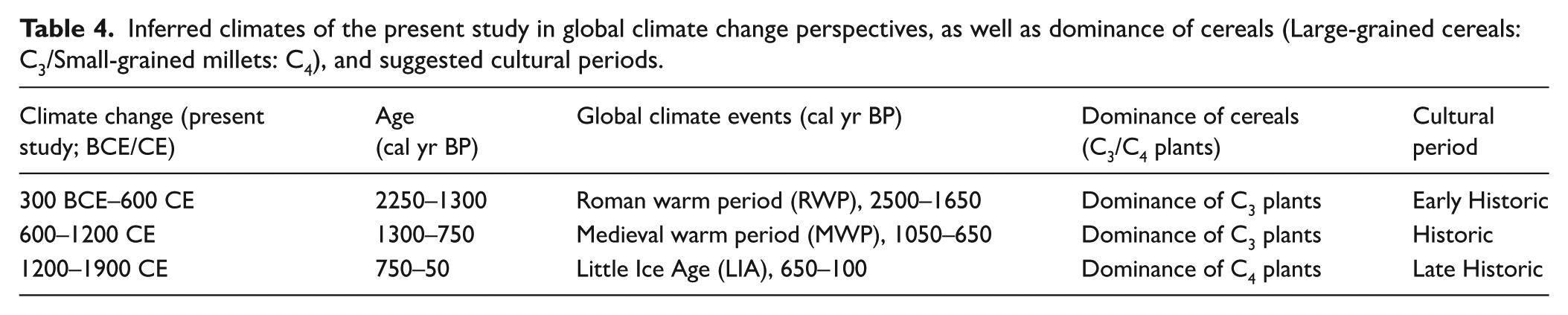
The monsoonal (ISM) variability of the present study during the recorded global climate events, such as RWP (300 BCE–600 CE; 2250–1300 years BP), MWP (600–1200 CE; 1300–750 years BP) and LIA (1200–1900 CE; 750–50 years BP), and their comparison with the globally accepted data of RWP (2500–1600 years BP), MWP (1050–650 years BP), and LIA (650–100 years BP) has been shown in the summary diagram (Figure 7; Table 4).
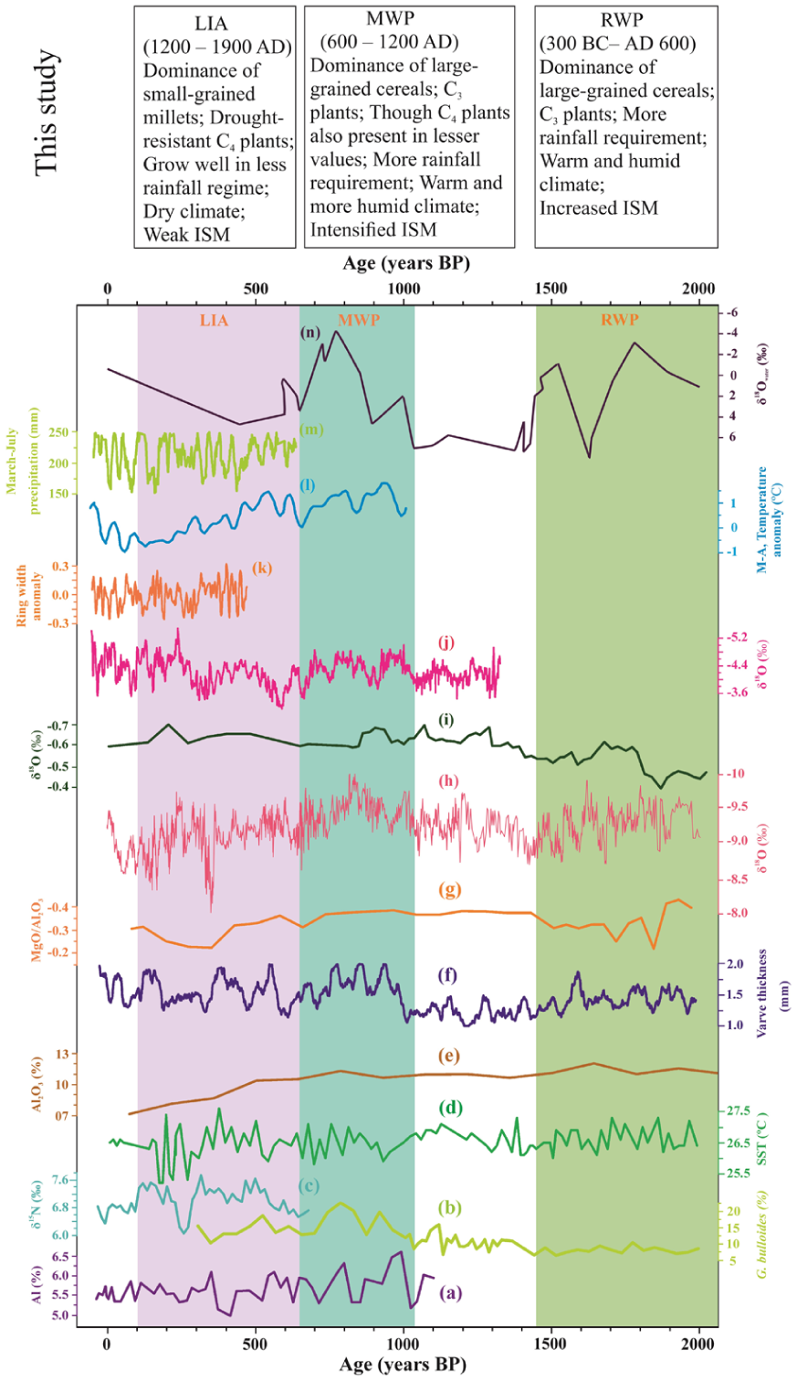
Summary diagram showing the ISM variability recorded during global climate events, such as RWP (300 BC/AD 600; 2250‒1300 years BP), MWP (600‒1200 AD; 1300‒750 years BP), and LIA (1200‒1900 AD; 750‒50 years BP) in the present study, and comparison of globally accepted climate anomalies during the Roman Warm Period (RWP; 2500–1650 years BP), the Medieval Warm Period (MWP; 1050–650 years BP), and Little Ice Age (LIA; 650–100 years BP), recorded from (a); the Eastern Arabian Sea (Agnihotri et al., 2002); (b) North-west Arabian Sea (Gupta et al., 2005); (c). Eastern Arabian Sea (Agnihotri et al., 2008); (d) NE Arabian Sea (Doose-Rolinski et al., 2001); (e) Diu Island (Banerji et al., 2017); (f) NE Arabian Sea (Von Rad et al., 1999); (g) Rohisa, Gujarat (Banerji et al., 2019); (h) Speleothem δ18O record of the Sahiya Cave, Uttrakhand (Kathayat et al., 2017); (i) Andaman Island (Laskar et al., 2013); (j) Jhumar Cave, Chhattisgarh (Sinha et al., 2011); (k) Teak (Tectona grandis) tree ring width records from Kerala (Borgaonkar et al., 2010); (l) HPJ, Himachal Pradesh (Yadav et al., 2011); (m). Purbani, Himachal Pradesh (Singh et al., 2009) and (n) Vadnagar Archaeological Site, Gujarat, India (Sarkar et al., 2024).
Conclusion
The excavations at Nagardhan have provided valuable insights on culture-climate-subsistence relationships from the Early Historic to the beginning of the Modern Era. The present work highlights the evidence of adaptive human response to warm, humid and warm, dry or arid environments in central India, ca. 300 BCE–1200 CE and 1200–1900 CE respectively, associated with significant global climatic events, such as RWP, MWP, and LIA. Good correlation between the ISM rainfall and the diversity index of cereals, pulses, etc. was observed, and there is a clear indication for increase in biodiversity of plant species, including a wider range of crops, during the Early Historic to Historic Periods (300–1200 CE), followed by a decrease in diversity along with rainfall during the Late Historic Period (1200–1900 CE). The site testifies to significant changes in agricultural practice, including the embrace of the cultivation of small-grained millets with time. The overall interpretation of the present study is that the inhabitants were able to adapt to the climatic events of the past two millennia, expand their agricultural package to take advantage of higher rainfall, and were able to survive during periods of climate deterioration by switching to drought resistant crops such as millets.
Supplemental Material
sj-docx-1-hol-10.1177_09596836251378017 – Supplemental material for Evaluating the Indian Summer Monsoon intensity using archeological seeds from early–late historic Vidarbha, Central India
Supplemental material, sj-docx-1-hol-10.1177_09596836251378017 for Evaluating the Indian Summer Monsoon intensity using archeological seeds from early–late historic Vidarbha, Central India by Himani Patel, Ruchita Yadav, Virag Gopal Sontakke, Shantanu Vaidya, Shrikant Ganvir, Mohammad Firoze Quamar, Paulramasamy Morthekai, Liya Tang, Mansi Swaroop, Alka Srivastava, Michael Spate, Keir Magalie Strickland, Nagendra Prasad and Anil K Pokharia in The Holocene
Supplemental Material
sj-png-2-hol-10.1177_09596836251378017 – Supplemental material for Evaluating the Indian Summer Monsoon intensity using archeological seeds from early–late historic Vidarbha, Central India
Supplemental material, sj-png-2-hol-10.1177_09596836251378017 for Evaluating the Indian Summer Monsoon intensity using archeological seeds from early–late historic Vidarbha, Central India by Himani Patel, Ruchita Yadav, Virag Gopal Sontakke, Shantanu Vaidya, Shrikant Ganvir, Mohammad Firoze Quamar, Paulramasamy Morthekai, Liya Tang, Mansi Swaroop, Alka Srivastava, Michael Spate, Keir Magalie Strickland, Nagendra Prasad and Anil K Pokharia in The Holocene
Supplemental Material
sj-png-3-hol-10.1177_09596836251378017 – Supplemental material for Evaluating the Indian Summer Monsoon intensity using archeological seeds from early–late historic Vidarbha, Central India
Supplemental material, sj-png-3-hol-10.1177_09596836251378017 for Evaluating the Indian Summer Monsoon intensity using archeological seeds from early–late historic Vidarbha, Central India by Himani Patel, Ruchita Yadav, Virag Gopal Sontakke, Shantanu Vaidya, Shrikant Ganvir, Mohammad Firoze Quamar, Paulramasamy Morthekai, Liya Tang, Mansi Swaroop, Alka Srivastava, Michael Spate, Keir Magalie Strickland, Nagendra Prasad and Anil K Pokharia in The Holocene
Footnotes
Acknowledgements
We are thankful to the Director, Birbal Sahni Institute of Palaeosciences, Lucknow, India for providing the infrastructure facilities needed to complete the study. AKP is thankful to State Archeology Department, Nagpur, Maharashtra and Deccan College and P.G. Research Institute, Pune, Maharashtra for providing an opportunity to analyze remains collected by the excavators during the course of excavation by applying floatation technique in parallel. We also thank the reviewers for their invaluable suggestions, which led to important clarifications in the manuscript.
Author contribution(s)
Funding
The authors received no financial support for the research, authorship, and/or publication of this article.
Supplemental material
Supplemental material for this article is available online.
References
Supplementary Material
Please find the following supplemental material available below.
For Open Access articles published under a Creative Commons License, all supplemental material carries the same license as the article it is associated with.
For non-Open Access articles published, all supplemental material carries a non-exclusive license, and permission requests for re-use of supplemental material or any part of supplemental material shall be sent directly to the copyright owner as specified in the copyright notice associated with the article.